2. Materials and Methods
The main method of the research is a case study, observing the phenomena within the context of the study area, limited to the western region in Serbia and the micro-location within it. The authors chose a case study methodology as the most applicable and relevant model because it offers the possibility of observing the process as an example. In addition, the study discusses the planning methodology regarding the relationship between the purpose of the new planned mine structures and the environmental context, as well as the expressed public opinion and the more focused political question. As the main material for analysis, the authors used the document outlining the spatial plan for the special purpose area of the Jadar project, regarding the exploitation and processing of the mineral jadarite [
5], along with the legal framework for its production.
In the literature review, according to the main topic and case study location, the authors provide a selective but extensive relevant review of previously conducted international research, which is both theoretical and based on similar case studies related to the topic. The special emphasis is on choosing those studies that consider the issue of fitting into the surrounding and analyzes the project’s impact on the environment. For the case study, there is an overview of the characteristics of the location, from the aspects of protection, followed by a synthesis of the various conditions, limitations, benefits, and capacity for planned facilities. The discussion considers the environmental question, pointing out the most important moments and stages in shaping public opinion, as well as presenting a summary of the key criticisms and proposed planning solutions.
The academic relevance of the paper is that it contributes to our understanding of those instruments that are essential in the realization of strategic goals regarding sustainable mining. A wider methodology is adopted with regard to a multidisciplinary and integral approach, combining the fields of knowledge regarding spatial and urban planning, protection, and preservation. This integrated method takes the benefits and disadvantages of this topic as arguments in the problem-solving approach and resolves possible conflicts within the context of sustainability, using assessment to determine how to harmonize specific spatial demands. In order to connect spatial planning with sustainable mining, it is important to cover several topics, starting with the procedures for developing, evaluating, and decision-making in terms of plans, while simultaneously analyzing the regional characteristics and potentials. The authors are following a matrix of chronology in producing a strategic plan and environmental impact assessments (EIA), respecting the demands as well as the restrictions and conditions. In order to emphasize the importance of the balance between growth and development, on the one hand, and the protection of natural resources and cultural values on the other, this paper gives an overview of the reactions to the publicity and decisions made by the Government, which concluded with the stopping of the project’s realization and the cancellation of the planned work. The scientific contribution in this paper is in the sphere of empirically conducted analyses on the spatial planning methodology and the demands for sustainability. Using a case study from practice, inspired by achieving an alignment between the protection of the environment and development, this paper debates planning techniques and methods as primary implementation instruments and indicates the possibility of failure, in spite of a scheme’s validity, if there is no public support and no political will to resolve the conflict.
Applying the principles of regulation and development in areas where strategically important mineral raw materials are exploited, as well as outlining guidelines for their management, is a behavior characteristic of large multinational companies (Rio Tinto, Rakita, and Zijin), particularly in locations in Chile, China, Australia, Mongolia, South Africa, etc. [
6,
7,
8,
9]. From the standpoint of harmonizing the planning and management process for areas of mining development in the world, especially in Europe, partnerships have been developed between large mining companies and all local actors [
10]. This procedural toolkit includes the harmonization of several key processes in the development of a mining area, from communication with the local population and the wider community, via planning, assessment, and evaluation, all the way to monitoring, management, control, implementation, and so on [
11,
12]. The sustainability of the final solution is the basic goal, but this goal is reached within a complex relationship and with the agreement of all actors and is only achieved through a transparent and democratic decision-making process [
13].
On the one hand, we see the tendency toward the pursuit of sustainable and clean energy [
14], which is in line with the goals of the United Nations’ Agenda—Transforming our World: the 2030 Agenda for Sustainable Development [
15]; on the other hand, we have the fact that the raw material that enables this development comes from the process of mining and processing raw materials that certainly has a significant impact on the environment, and where not all the consequences can be seen without clearly defined technology and detailed analysis in a specific area. Germany, for example, a country that is committed and exclusively oriented to the principles of sustainable development, is still considering the possibility of lithium exploitation in Saxony and the Upper Rhine Valley, in terms of its cost-effectiveness and environmental impact, and so, for now, it only imports the raw materials, which means that some of the “dirty technology” takes place elsewhere. This paper seeks to present the planning position and methodological approach in the development of the spatial plan, with special emphasis on the resulting conflict and the behavior of the public and the decision-makers.
3. Results
Lithium, one of the components of jadarite, is a key raw material for the production of batteries for hybrid and electric cars and high-tech devices. The use of lithium is particularly important in the industry that is currently developing to replace the dominant use of fossil fuels, i.e., it has a vital role in the transition to renewable energy sources [
16,
17]. The Adriatic Basin is the only jadarite deposit in the world, and this mineral can be exploited not only for the production of lithium carbonate, which is suitable for the production of batteries for electric cars and batteries for energy storage from renewable sources, but also for products such as borate (used in solar panels, wind turbines, the chemical industry, glass production, fertilizers, etc.) and sodium sulfate (used in the textile industry, glass production, etc.). For 18 years, the world mining giant, Rio Tinto, which is based in London, Australia, and Colorado in the USA, together with its locally registered company, Rio Sava Explorations d.o.o., from Belgrade, has been conducting exploratory drilling for jadarite in the Adriatic Basin in an area of 200 km
2, making over 300 exploration wells, on the basis of a permit for exploration works. Rio Tinto has so far invested over USD 200 million in the Jadar Project, and during 2021, the company allocated the project substantial funds, on the understanding that it obtained all of the necessary approvals, permits, and licenses, acting in constant cooperation with the local community, the Government of the Republic of Serbia, and the civil sector. Rio Tinto conducted about 2000 tests to develop innovative jadarite-processing technology. An estimate of the quantity of ore was carried out for only part of the deposit (Lower Jadarite Zone), which is the richest seam in terms of content and amounts to about 136 million tons of ore. The priority was to achieve long-term solutions for the development of a new, modern, and safe mining and industrial complex.
The process of extraction/separation of the lithium from the ore may vary, depending on the specific mineral deposit. Previous examples of lithium exploitation around the world are mainly based on its extraction from the spodumene, a form of lithium-bearing pyroxene, part of the hard-rock (pegmatite) Li deposits. Salars contain lithium-rich brine (fluid)—that evaporates under hot and arid conditions in the South American Atacama Desert. Drilling is required to access the underground deposits of saline brines, and the solution is then pumped to the surface and distributed as a vapor [
18]: ‘’Lithium is mainly recovered from minerals by acid, alkaline, and chlorination processes, and from brines by crystallization, solvent extraction, and ion-exchange processes’’ [
19]. The brine could, therefore, remain in the evaporation lake for several months or years, until most of the water is removed via solar evaporation [
20,
21,
22].
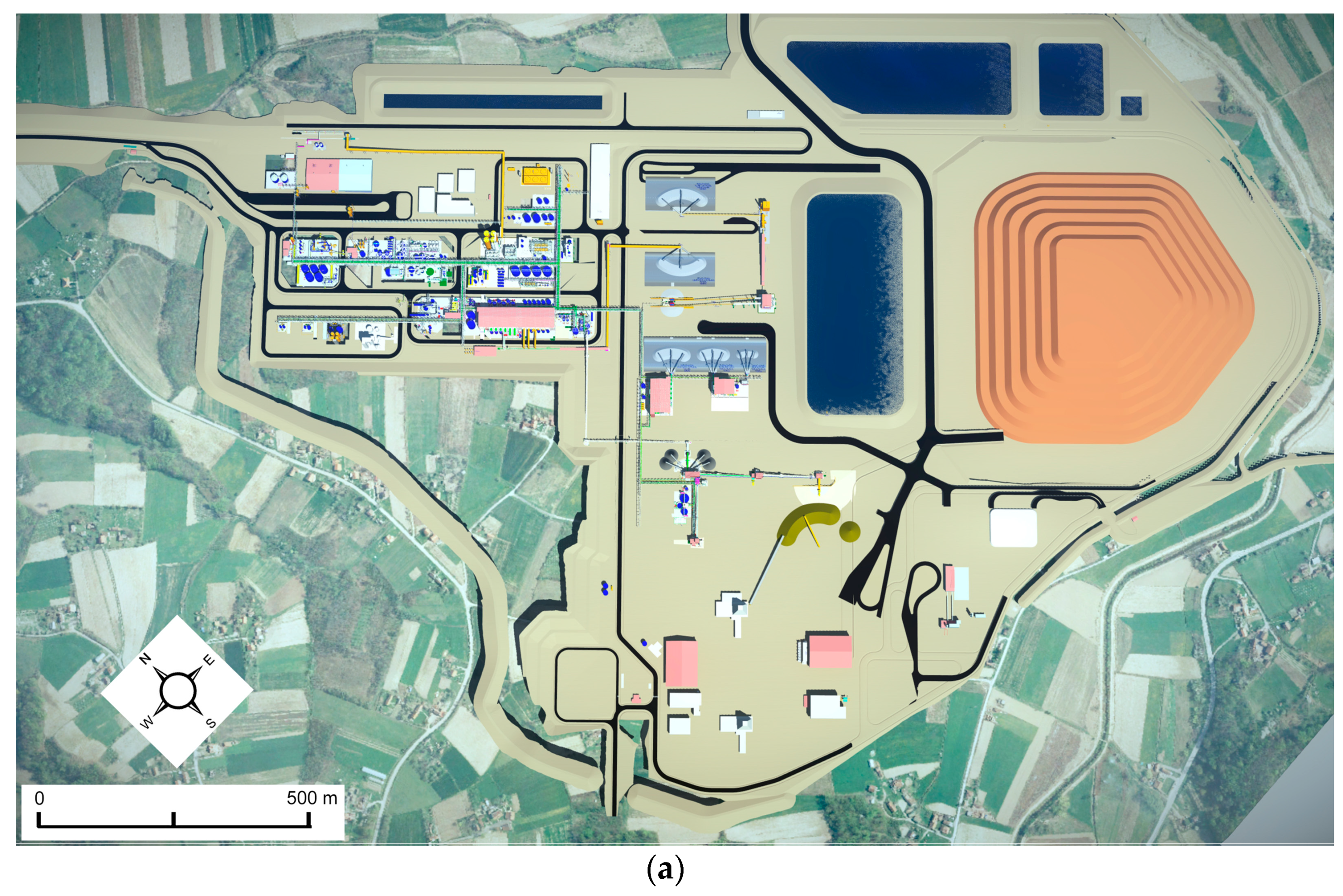
On the other hand, although they make up a relatively small part of the world’s lithium production, other mineral ore deposits yield almost 20 tons of lithium per year, and over 100 different minerals contain some quantity of lithium. The deposits of other mineral ores are often richer in lithium content than saline brines, but they are expensive to access because they must be extracted from solid rock formations. In general, the procedure involves the preparation of mineral raw materials for the production of the ore concentrate (crushing, sifting, etc.). Crushed mineral powder is combined with chemical reactants, then the suspension is heated, filtered, and concentrated through an evaporation process, in order to obtain, most commonly, lithium carbonate as a product. The water used in the process, including water from the plant, technical water, and water obtained by reverse osmosis, is introduced into reservoirs and is then purified, in accordance with current regulations on the established limit values set by the state in which territory the mine is located before purified water is returned to the recipient water body-river. The most common method around the world for disposing of the waste from this kind of production is in a tailings pond, that is, a liquid industrial waste dump. However, from the aspects of environmental protection and the rational use of space, the establishment of a solid industrial waste landfill in the form of a filter cake is a far more favorable option.
Given that jadarite ore has a specific composition, the technology for extracting the lithium has still not been fully defined and is currently being tested at the Bundora Technology Development Center in Melbourne, Australia. As stated in the official presentation by Rio Tinto, the standard technological scheme for processing jadarite showed that it is possible to produce high-quality products with the envisaged degree of useful components, while in another campaign, two innovative processes were introduced, offering results that exceeded all expectations [
23].
3.1. The Most Important Aspects of Planning Mining Systems
In most European countries, the design process, which is more technical and less strategic, dominates the preparation of planning documentation, while the content of the plans, if they exist, is extremely incohesive. However, intensifying certain aspects of environmental protection and strengthening the role of spatial planning, as the basic instrument for directing the spatial dimension of sustainability, and linking these aspects to the development of the mining and industry sectors increasingly necessitates the preparation of spatial plans and their coordination with the preparation of feasibility studies and technical documentation. Different models for the planning and design of mining and industrial production systems are available, which, on the one hand, must be harmonized with national legislation, integrated into existing planning systems, and synchronized in the international context, while, on the other hand, they must provide a basis for the quick implementation of procedures. For this reason, it is not possible to recognize a clear or unique planning model for such areas in international practice. One gets the impression that the model is closely connected and develops through the basic stages of the spatial planning system in general, from urban planning by means of construction rules, through land use planning in a wider area, all the way to regional economics and, finally, integral planning, more or less successfully synchronizing all sectors that have an influence on the space.
In the spatial planning of large mining concerns and industrial production systems, several challenges can be singled out that need to be solved through the practice of preparing plans. The first refers to the mutual harmonization of the planning and design processes (the production of technical documentation) for mining, ore processing, industrial production, and industrial waste disposal facilities and systems. The legislative framework defines the content and procedure for several levels of plans and projects; however, it does not sufficiently clarify their mutual relationships. It is also imperative to solve almost all the known issues in one planning document, which should be the basis for designing the preliminary project and solving property relations. In order for such a planning concept to succeed, it is necessary, through further methodological practice, to harmonize all phases of the planning, project, and technical documentation, in terms of content and procedure. For example, in terms of content, the emphasis when preparing a plan for a special purpose area is on many topics, including: looking at and defining the ways and conditions for fitting the system into the wider space; defining protection zones; the method of making a connection with the surroundings; ensuring the public and democratic nature of the procedure; strategic assessment of the environmental impact; creating the basis for settling property relations on the land. The emphasis in preparing the design and technical documentation is on certain issues, including: the implementation of previous preparatory works; determining the macro location of the structure; defining, evaluating, and selecting technical and spatial solutions; considering traffic, technical, technological, and economic justifications; determining the micro-location of the structure (the infrastructure route); considering construction and maintenance costs; making an environmental impact assessment; creating the foundations for construction.
A special aspect of planning such areas is defining the planning solutions, with regard to the development of traffic and infrastructure, in such a way as to enable the development of mining and industry as a special purpose and function, while at the same time fitting and integrating those systems into existing and planned national, regional, and local networks.
The challenge in practice also relates to determining the protection and impact zones and prescribing their regime of the use, organization, and protection of the space within them, with the aim of protecting the immediate environment from a potential chemical accident, air and water pollution, the impact of noise, land subsidence, and so on. It is also important to harmonize the planning concept with the existing situation in the area and the obligations arising from existing, valid plans and projects.
Spatial planning practice tries to respond adequately to such key questions and other problems. At the same time, in recent years, the technical aspect and the need for the direct implementation of spatial plans, i.e., the design of elements of detailed regulation in the spatial plan, has been particularly emphasized, which creates the basis for issuing conditions related to the location for the purposes of further design, determining public interest, and resolving property relations.
In addition, in the system and practice of managing the use and protection of natural resources in Serbia, the coordination of different policies and the relativization of conflicting interests is only possible through the process of spatial (and urban) planning. Therefore, it is necessary to develop new methodological approaches that are aimed primarily at integrating strategic and urban planning and synchronizing the planning and design processes, as well as facilitating cooperation between the public and private sectors in the sustainable development of mining and the economy, while protecting and maintaining the quality of the environment. In this context, an important role is played by the process of creating and implementing spatial plans for special purpose areas for the exploitation of mineral resources.
For these reasons, the spatial plan for the special purpose area of the Jadar project regarding the exploitation and processing of jadarite minerals (Decree on Establishing an SPSPA), is interesting, in the context of establishing and examining the possibility of applying a new methodological procedure as a coordination instrument for opening a modern lithium mine, industrial plant, and supporting the infrastructure in a responsible, legal, and sustainable manner. The further development of events after the verification of the planning solution is also interesting for analysis, within which period the legally guaranteed participatory procedure was carried out, and after which there was a stormy reaction and protests by a series of NGOs (Protect Jadar and Rađevina, Defend the Rivers of Stara Planina, Podrinje Anti-Corruption Team—PAKT, Go-change, Society for the Protection and Study of Birds, etc.) and the local population, which ultimately caused the project to be stopped (Decree on the Termination of Validity of the Decree on Establishing the SPSPA).
3.2. Methodological Concept of the Spatial Plan for the Jadar Project
The new methodological procedure used for preparing the Spatial Plan for the special purpose area of the Jadar project for the exploitation and processing of jadarite minerals [
4] was based on applying an integral and problem-solving approach to the use of strategic natural resources, along with the resolution of possible conflicts, the coordination of public–private partnerships, and the harmonization of national and local interests, as well as the protection and improvement of the environment. Throughout the process of preparing the spatial plan, it was particularly important to analyze and establish all the problems in planning and decision-making that had arisen until that point with regard to the development of mining and industrial production zones, as well as conditions regarding the construction of traffic and other infrastructure. The results of the analysis indicated new aspects that needed to be considered.
From a spatial and functional perspective, unlike common practice prior to this point, the subject of the planning is an underground mine (with access via a vertical shaft), incorporating an accompanying zone on the surface that is directly connected to the zone envisaged for ore processing and further industrial production activities. Disposal of the industrial waste from the production area, due to spatial limitations, requires moving the disposal zone to a location about 10 km from the plant. In addition, the need for vehicular access and infrastructural equipment for the planning area imposes the obligation to plan and build a whole series of new traffic and infrastructure facilities, starting with those of broader national and international importance, through facilities and systems designed exclusively with a special purpose, all the way to systems that enable integration into local traffic and infrastructure networks. In terms of organization and assets, the jadarite mineral exploitation and processing project for which the spatial plan was developed was initiated and financed by the private sector, that is, by an international mining company and its branch in Serbia.
The above-mentioned aspects necessitated an additional emphasis on the technical nature of the spatial plan and the goals of its preparation, aimed at the development of the private sector in the economy (mining, industry). Therefore, the methodological framework that was applied to produce the spatial plan is new; it is based on the combined application of an integrative and participatory approach, in the process of deciding on the sustainable development of part of the economic sector. From this comes the main aim of producing the spatial plan, which is to define the planning basis and secure the spatial conditions for the overall sustainability of the spatial development of the area that is covered, and the rational exploitation of mineral deposits and other resources in the deposit, as well as for the neutralization or mitigation of the negative spatial, environmental, and socioeconomic consequences of the exploitation and processing of mineral raw materials.
It was determined that in terms of the planning and management of the sustainable development of the mining and industrial production zones and their impact on the environment (immediate and regional), the key problem is the coordination of spatial planning, including urban planning and strategic environmental impact assessment, as well as the sectoral planning of mining, industry, and traffic infrastructure, namely, the preparation of all levels of technical documentation (from the general project to the preliminary and main projects).
Based on the established problems and identified conflicts with regard to achieving sustainable spatial development, the basic principles for the coordination of planning decisions were defined, among which the starting point was to harmonize the planning solutions in the spatial plan with the solutions from the feasibility study (mining, industry), and the general and preliminary project (traffic and other infrastructure). This raises several questions, including whether these solutions increase industrial production, increase traffic accessibility and the level of infrastructure equipment, and reduce adverse effects on the development of settlements, as well as whether they protect natural resources, natural and cultural heritage, etc. For the application of these principles, the convenience and challenge related to having technical documentation at different levels of completion, and the possibility of synchronizing the technical planning documentation must be surmounted. The documentation is at: (a) the level of the previous feasibility study for the mine and mining facilities; (b) the level of the feasibility study, regarding industrial production facilities; (c) the level of the general project, for planning a new section of the IB-class state road, number 27, from Valjevo to Loznica; (d) the level of the preliminary project for the planned Valjevo-Loznica railway line, planned access roads, planned high-pressure gas pipeline, and planned electric power transmission lines, developed in parallel with the preparation of the spatial plan. As a result, a two-fold approach to the coordination of planning solutions was applied: (a) the planning solutions of the spatial plan were coordinated with the technical documentation at the level of the general project and feasibility study; (b) the planning solutions from the spatial plan and elements of the preliminary project were coordinated with each other. A participatory approach was applied to the preparation of the spatial plan and the preparation of the technical documentation so that the planning solutions were checked and adjusted, based on input received at a national level, as well as from stakeholders and members of the public.
3.3. Important Features of the Spatial Plan for the Jadar Project
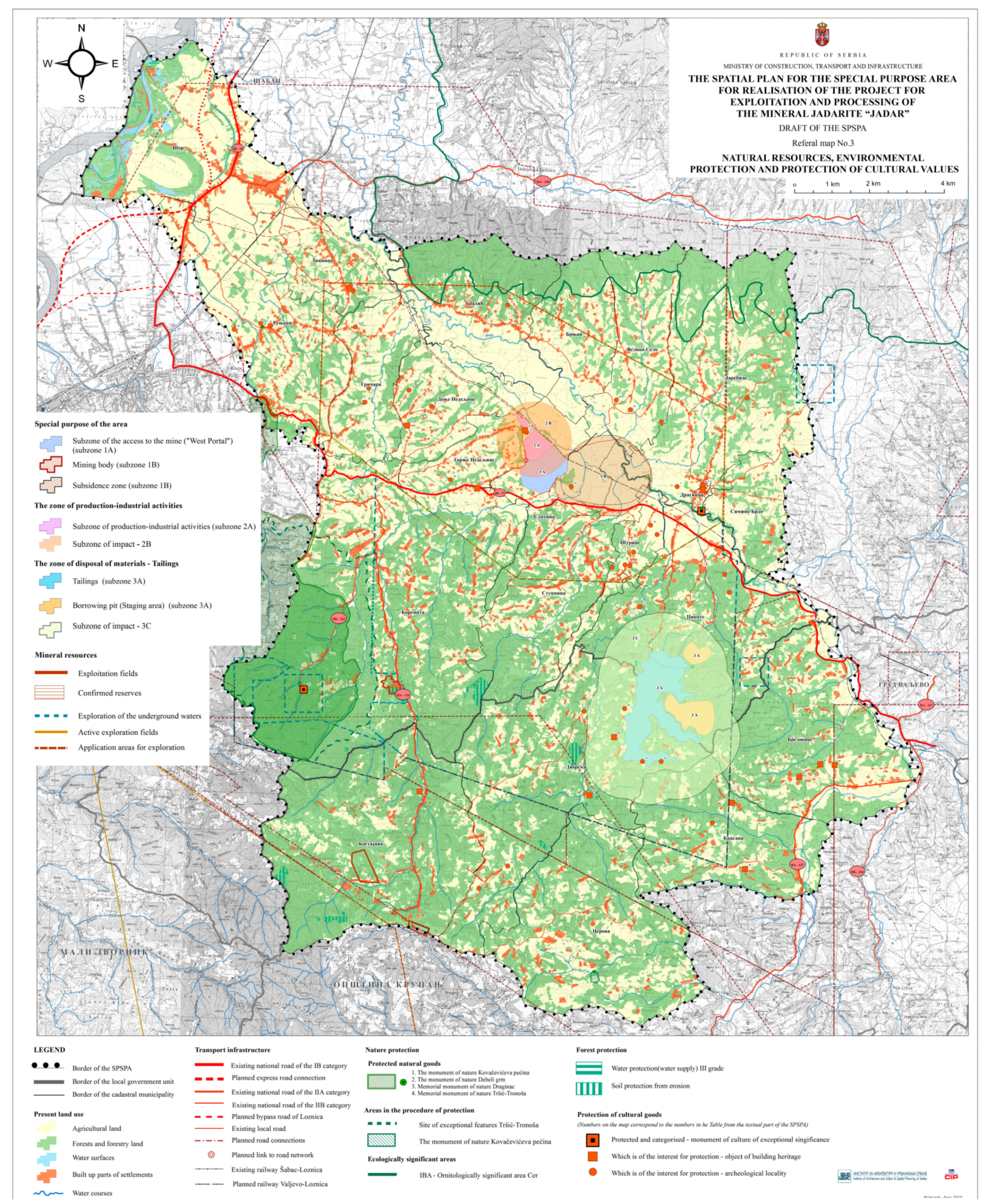
The area covered by the spatial plan includes 293.91 km2 of the territory of the city of Loznica and the municipality of Krupanj. Spatial development of the Jadar Project includes previous exploration, the change of purpose and land-use regime, the construction of buildings, roads, and infrastructure, the implementation of mining activities, ore processing, production, the disposal of materials, the establishment of protection measures, and the development of other activities, in an area covering approximately 2030.64 ha, which is a special purpose area in a broader sense, and which also represents preliminary coverage of the detailed regulatory planning solutions (at a scale of 1:2500).
With regard to the concept of spatial development, future functions, land use, and the rules of arrangement and construction, the space required for the implementation of the Jadar project can be divided into several zones and subzones.
(1) Mining activity zone—this includes the area needed for mining activities and the space where these activities will have an impact on the environment, with an area of 854.8 ha, which is divided into two subzones. The subzone with access to the mine includes the space required for access to the mine and the construction of the mine’s surface facilities, covering 140.24 ha. This spatial plan requires a permanent change in land use to become construction land, with the special purpose of mining and the accompanying facilities and activities in the subzone. The subzone of the mine and the impact of mining activities on the environment covers the area in which the mining activities will take place in the narrower sense, that is, the area defined by the ore body within which the underground mine will be formed, and the mining and exploitation of the ore (the jadarite mineral) that will be carried out. This subzone also includes the areas above the mine, which will be impacted by the mining activities, i.e., the possible subsidence of the ground, an area of 849.81 ha. In this subzone, the existing purpose of the land (mainly agricultural land) is retained, and the construction of new buildings is prohibited, except for those buildings with a special purpose and for agriculture.
(2) The industrial production zone—this includes the space and areas required for the construction and formation of a complex in which ore processing and further production are carried out, as well as the area where these activities will have an impact on the environment, a total area of 646.54 ha. This zone is divided into two subzones. The industrial production zone includes the space and area required for the construction and formation of a complex in which ore processing and further industrial production (of lithium carbonate, sodium sulfate, and boric acid) is carried out. This sub-zone is defined by the boundary of the complex and covers an area of 79.8 ha. The spatial plan permanently changes the purpose of the area and land use in this subzone into construction land, with the special purpose of industrial production and the accompanying facilities and activities. The subzone of environmental impact from the industrial production activities includes a protection zone of 1000 m around the complex, i.e., an area of 646.54 ha. In this subzone, the existing purpose of the areas is retained, while the construction of new buildings is permitted, with the exception of public buildings.
(3) The industrial waste disposal zone—this includes the space needed for industrial waste disposal, with an area of 358.52 ha. It consists of two subzones. The sub-zone of the disposal zone includes the space necessary for the formation of an industrial waste landfill, the construction of a dam, service roads, infrastructure, and other supporting facilities next to the landfill, with an area of 164.71 ha. The spatial plan permanently changes the purpose of the area and land in this zone to construction land, with the specific purpose of constructing a landfill site, roads, and infrastructure. The sub-zone of the impact of this industrial waste landfill on the environment includes a protection zone of 500 m around the landfill facilities, i.e., an area of 193.81 ha, in which the existing purpose of the area (mainly forested land) is retained. This subzone is a controlled construction zone, in which the construction of traffic, infrastructure, and water management facilities that are related to the landfill is permitted. The existing facilities are retained, while the construction of new facilities is prohibited.
(4) The special purpose zone of the traffic and infrastructural corridor—this includes the corridor for the planned railway line, the planned new section of the IB class state road, number 27, from Valjevo to Loznica, the planned lateral high-pressure gas pipeline, and the special purpose pipeline for technical water, with an area of 480.02 ha.
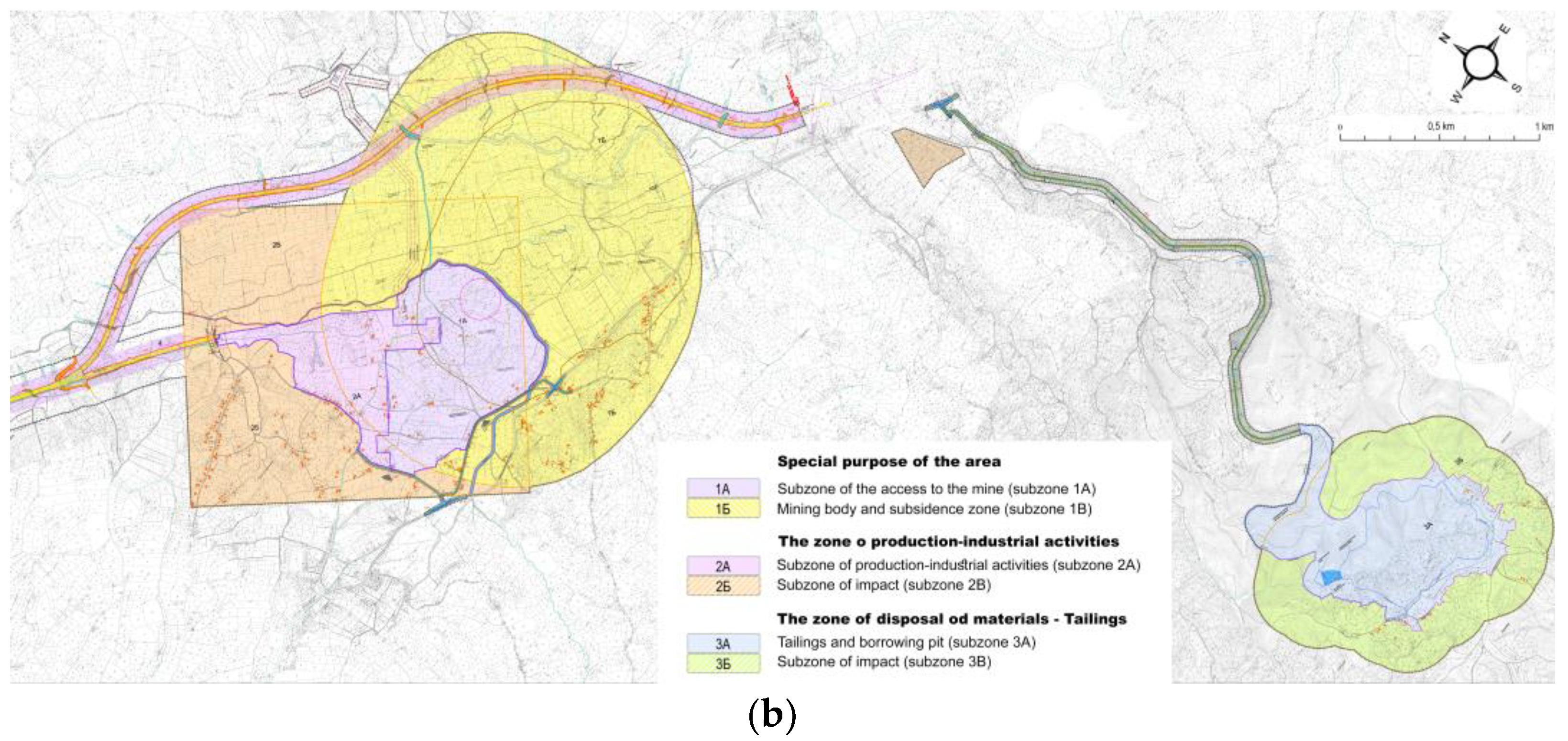
The mine access subzone, the subzone of industrial production activities, and the landfill subzone make up a special purpose complex in the narrower sense, i.e., an economic and industrial complex that covers an area of 384.75 ha, where there is a permanent change of land use for the implementation of the Jadar project (
Figure 1).
3.4. Contribution and Improvement of the Methodological Procedure
The specificity of the spatial plan, in addition to the special purpose complex, can be seen in the definition of the traffic and infrastructure corridor zone, for which it was necessary at the planning stage to coordinate the technical solutions and harmonize the routes and protective corridors of several traffic and infrastructure systems. A special contribution to this plan is the harmonization of technical solutions at different levels of processing (the general, preliminary, and main project levels), for structures with different ranks (national, regional, and local), as well as different requirements and conditions regarding the definition of protective zones and land-use regimes in them. Therefore, for each traffic and infrastructure system in the corridor (railway, I-class state road, high-pressure gas pipeline, the 110 kV power line, technical water pipeline, etc.), not only is land for public purposes analytically determined but also the routes and exploitation and the protection belts are prescribed, as well as the corresponding regimes of protection, use, and the arrangement of the space within them.
Determining the impact zones set aside for special purposes (
Figure 2), as well as the belts and protection regimes for traffic and infrastructure systems, indicates a new methodological framework that has been applied in the development of this spatial plan, primarily with the aim of achieving a compromise in spatial development between economic functions (mining, industry) and other functions in the space. Through the methodological approach, the current situation is also recognized at the same time, especially with regard to construction in the area; the reconstruction and rehabilitation of existing buildings is allowed, but without the possibility of changing their dimensions or volume, as long as they do not endanger the function of the special purpose and if adequate protection from negative effects can be ensured via technical solutions. In this way, planning solutions are defined that respect and enable the existing functions in the space (housing, economic activity, etc.) under certain conditions, while, at the same time, introducing a ban and stricter regimes for new activities and functions.
In order to improve the quality of accessibility for the local and regional surroundings and the infrastructural equipment, the spatial plan has devised several solutions, including: (1) the planned section of the Šabac–Loznica IB-class state road, with a length of 13.75 km, which, in addition to having a special purpose and function, serves as a new bypass that takes transit traffic away from the construction area in the city of Loznica; (2) planned access roads that are envisaged as public road and, thus, in addition to having the function of access to the special purpose complex, they also increase local accessibility, along with the planned reconstruction of three intersections on the existing state road; (3) the planned section of the Valjevo–Loznica railway line, with a length of 9 km, the route of which takes into account the existing condition by retaining the function of all local roads with which it intersects at different levels; (4) the planned high-pressure gas pipeline, with a length of 8.6 km, through which gas will be supplied to a wider area that is covered by the plan.
The special contribution and importance of the methodology of integrated planning that was applied can be seen in the simultaneous development of planning solutions on two levels, namely, the strategic level of the spatial plan (reference maps at a scale of 1:50,000) and the detailed level of the urban plan (thematic maps of detailed regulation at a scale of 1:2500). With the previously agreed technical solutions, including a detailed regulatory elaboration for all of the mentioned zones and systems covering a total area of 2030.64 ha, it is possible to implement the spatial plan directly, by issuing location conditions, including: all facilities within the special purpose complex; the section of the planned railway line Valjevo–Loznica; a planned lateral high-pressure pipeline; planned technical water pipeline; planned public roads, including planned intersections on the IB class state road number 27; a planned 110 kV transmission line.
The new methodological framework that was applied in the spatial plan represents the basis for determining the public interest in expropriation, which refers to the administrative transfer of immovable property. The spatial plan formed construction plots for public purposes for roads, railways, the regulation of surface flows, and other infrastructure facilities. At the same time, a list of all the cadastral parcels (whole or partial) within the zones and subzones set aside for special purposes is given, along with the protective belts of the infrastructure systems. Another special contribution of the new methodological approach is made by the definition of the rules for the arrangement and construction of buildings for special purposes, i.e., for mining and industrial production purposes, which are of a specific nature and for which individual rules are defined here for the first time (the compatibility of purposes and systems of a technical nature).
The spatial plan was created in a GIS environment, based on ESRI technology (ArcGIS 10), which enables simpler data exchange, the formation of a geographical information system for the area that is covered, and more efficient control over implementing the spatial plan.
3.5. The Aspects of Sustainability and the Participatory Process
A total of 71 conditions and 20 opinions and consents to the planning solution were collected for the purposes of preparing the spatial plan and the strategic environmental assessment, issued by the relevant holders of public authority—state subjects at national and local levels (ministries of various departments, public utility companies, institutions for the protection of nature and cultural and historical monuments, etc.). All requirements are listed in the plan, i.e., they are respected and incorporated into the planning solution.
The planning solutions were checked and evaluated through a strategic environmental impact assessment of the planning documents. In the process of evaluating the planning solutions, the emphasis was placed on an analysis of their impact on what were potentially the most sensitive environmental factors in the specific area, in particular the impact of noise, air pollution, the transportation and disposal of industrial waste, and land subsidence. In addition, the potential impact of the project on the quality of life of the local population and the possibilities for neutralizing or reducing that impact were evaluated through a strategic impact assessment. The strategic environmental assessment included an evaluation of the possible solutions for the type/method of industrial waste disposal (tailings pool or dry-waste landfill) and the route of the access road for the landfill (the chosen variant was more favorable from the point of view of the environmental impact—presenting greater distances from the residential buildings and shorter slopes along the length of the road). The methodology applied in the section regarding the implementation of the planning solution was significantly improved, with a particular emphasis placed upon defining suitable measures for monitoring the environmental impact.
During the preparation of the spatial plan for the Jadar project and when changing the land use over to its planned purpose, the social aspect of the project was particularly closely analyzed and considered. Based on research and surveys in the field, the purchase of land and of real estate, and the relocation of households from the special purpose complex were envisaged. The entire resettlement process was defined in the Resettlement Planning Framework, in accordance with the business standards of the International Financial Corporation and the relevant laws of the Republic of Serbia. This framework is a guide to resettlement, and it describes the modality and conditions of resettlement. The modality and conditions are defined in order that households should be provided with the same or a better quality of life and work than they had experienced before resettlement. Self-relocation was determined as the preferred modality of resettlement. After households received monetary compensation for the purchase of their property from the investor, they should have been free to choose the replacement property that they wanted to move into. The developer should provide support in the resettlement process, especially to those who belong to vulnerable social groups or who explicitly ask the developer to buy replacement land on their behalf. The investor is responsible for supporting, financing, and monitoring the resettlement and restoration of economic activities of the households after their resettlement for a set period determined by the investor as part of the resettlement plan, a period of around 3 years.
In accordance with the legal regulations, the elaboration of the plan was presented to the public in two stages, first, for 15 days in the preliminary phase, then, for 30 days in the draft phase. At the same time, the investor involved in the Jadar project had organized a “reception office” on-site, where relevant information about the project could be obtained. During the public insight period, a total of 8 objections to the planning decision were submitted (with a total of 18 items, because some submitters had multiple objections), of which 6 (a total of 16 items) were from citizens, i.e., local residents, 2 were submitted by holders of public positions (public enterprises) and none were submitted by non-governmental organizations. The largest number of objections were related to personal property and its purchase, often with the proposal that plots should enter the purchase zone, and a smaller number were related to the impact assessment regarding property that remained in the protection zones of the mine; none of them contested the project itself. After the public session and discussion, the conclusion was reached by the expert committee that one objection from a local resident and two from public companies, i.e., a total of 3, were accepted in their entirety, and 4 objections were rejected, while 11 objections were concluded to be unfounded. Along with the plan, an elaboration of the accompanying strategic environmental impact assessment (SEA) was presented, to which 3 objections (9 items in total) were submitted, all made by public companies, i.e., not a single objection was submitted by the citizens or non-governmental organizations. Out of these 9 items, 4 were accepted in full, 1 was accepted in part, and 4 were rejected, i.e., not accepted. Finally, after corrections to the plan and SEA in accordance with the accepted objections, as well as the submitted conditions, and with the consent of all relevant holders of public authority, the plan was adopted in mid-March 2020 by a Decree of the Government of the Republic of Serbia, with the impression that there were no key objections or obstacles to the implementation of the project with regard to the location of the mine or its impact on the population or the environment. After the adoption of the SPSPA, the legal obligation was to conduct an environmental impact assessment on the Jadar project as a prerequisite for issuing a construction permit. However, everything was suspended after 20 January 2022, when the Government of the Republic of Serbia passed a decree for the termination of the Jadar SPSPA and, thus, put a moratorium on the implementation of this project. It was originally planned that construction of the mine would begin in 2023, and the opening of the facility was planned for 2026.
3.6. Environmental Uprising and Stoppage of the Mine Project
After the adoption of the spatial plan, protests began among the local population in the Jadar valley and in the area around Loznica, the so-called “Ecological Uprising”, which was organized by several environmental movements. The result of these protests was that in December 2021, Loznica’s city assembly did not verify the spatial plan of the city, which had been procedurally coordinated with the previously adopted Spatial Plan for the Jadar project. The protests spread throughout Serbia, based on the general state of the environment and a number of accumulated environmental problems (air pollution, the taking of agricultural land for non-agricultural purposes, the drinking water situation, the construction of mini-hydropower plants, etc.). However, the protests were mostly aimed at opposing the exploitation of lithium, not only in the Jadar valley but also in the whole of Serbia, and against the further activities of the Rio Tinto company in Serbia. In the meantime, the procedure for amending the Law on Referendum and the Law on Expropriation had been carried out, which gave rise to the suspicion that the laws were being changed in favor of the needs of investors, in this case, the company, Rio Tinto. One amendment had been abandoned, and the other was being implemented, with some of the demands of the protesting citizens being respected. There was also some political speculation about the possibility of a referendum on the issue of opening a lithium mine after the impact assessment of the Jadar project on the environment was complete. If the mine should begin to work, a percentage of the profit would be given to the state, and there is the possibility of the Republic of Serbia having to pay compensation for the funds that were already invested if everything ceased.
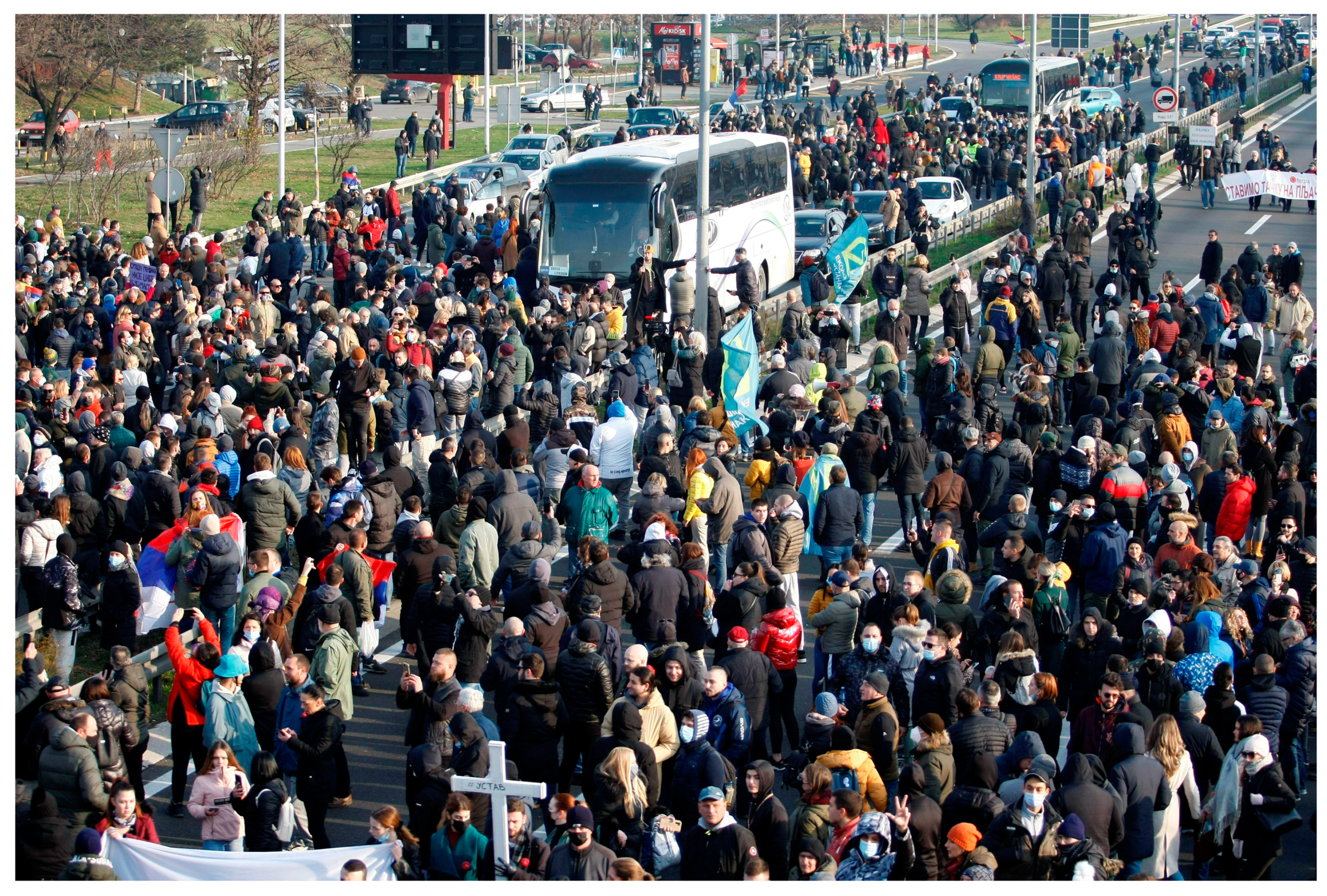
In January 2021, the protests significantly intensified and culminated in the blockade of key international and regional travel routes (
Figure 3), so that in the end, in light of the political climate before the elections (on several levels: presidential, parliamentary, and local), on 20 January 2022, the Government of the Republic of Serbia made a decision; that is, they issued the decree on the termination of the validity of the Spatial Plan for the Special Purpose Area of the Jadar project for the exploitation and processing of jadarite minerals. The final demand that was put forward by the environmental associations was the introduction of a moratorium on all further research and the eventual exploitation of lithium in Serbia, i.e., stopping the work of the company Rio Tinto, as well as that of other registered companies that carry out exploration work on potential deposits of lithium ore.
According to the Rio Tinto data from July 2021, in the village of Brezjak, this company had bought property, and around half of the 52 households had already moved out from an area covering around 40% of the 250 ha. area planned for opening the mine and the jadarite processing plant. Preliminary agreements have been signed with some residents, except with those whose property has already been bought [
23]. Concern had been expressed by members of the local population who did not wish to sell their property, or who remained in the area of the planned mine, ore-processing plant, or industrial waste dump, with regard to the assumption that it would result in terminal environmental pollution and the endangerment of their health and survival in that area. However, until just a year and a half ago, all these citizens had cooperated with Rio Tinto, had leased plots where the company had its drill holes, and had signed sales contracts with the company, only for them to be classed among the greatest opponents of opening a lithium mine, in the light of the strong campaign conducted against the activities of Rio Tinto in Serbia.
4. Discussion
The Spatial Plan for the Special Purpose Area of the Jadar project for the exploitation and processing of jadarite minerals, and the strategic environmental impact assessment, which was completed in 2019 and then adopted in 2020, were carried out in accordance with all legal procedures currently in place in the Republic of Serbia. This included meeting the necessary conditions, obtaining opinions and consent, and conducting expert inspections, public insight, and open discussions. Thus, the methodological approach to the development of the plan and the resolution of conflict situations, primarily in terms of the functioning of the mine and the sustainable protection of the environment, was confirmed in an appropriate manner. However, after the adoption of the plan and during the purchase of the property from the local population, there were protests by residents who remained in the wider areas around the proposed site of the mine and industrial production plant for ore processing, which were initiated by numerous environmental movements and organizations. The previous negative experiences that the multinational company Rio Tinto had undergone in other countries where it has engaged in mining operations (Papua New Guinea and Australia) were brought into the foreground, in terms of endangering the environment, disrespecting the local cultural and historical heritage, and endangering people’s lives. In addition, based on the experience of foreign companies in Serbia that are engaged in industrial and mining activities in other locations, it has been shown that environmental monitoring is at a very low level, i.e., despite the prescribed measures, incidents of air, water, and soil pollution have taken place. Firstly, the public was concerned about the mining activities in Zijin in the eastern part of Serbia, after several incidents in the Bor and Majdanpek mines, violations of ecological standards, evidence of pollution in the air of those towns and the Pek river, and the blasting and demolition of the mountain peak at Starica. The second case concerns iron and steel production in the town of Smederevo, which is managed by the HeSteel-HBIS Group, infamous for its constant air pollution activity and continued production without adequate filters. Nevertheless, the citizens were against the intensive investigative works of more than 20 foreign companies registered in Serbia, which were exploring possible deposits of minerals and precious metals.
The result of the protests, which began at the local level but spread across Serbia, was the political decision by the Government of the Republic of Serbia to “cancel” the plan and stop the implementation of the Jadar project [
24]. This resulted in numerous legal problems for all those entities that had participated in the planning process, from the company, Rio Tinto, via the ministries responsible for mining, construction, transport, and infrastructure, to local self-governments, public companies, and others. There are still unresolved issues with the conversion of land use, based on the plan (from agricultural to construction), the expropriation of land carried out for the purpose of constructing traffic and infrastructural systems (railroads, roads, gas pipelines, and other major infrastructure), construction bans, costs, and exploration rights over the past eighteen years, among others. The issues that particularly stand out involve the property acquired by Rio Tinto according to market conditions and in accordance with the law, as well as urban planning conditions, on the basis of which the project’s documentation was largely made. Further legal implications related to the protection of rights and the possibility of seeking reimbursement of the costs are not clear either, being based on international conventions that enable the protection of foreign investments, which Serbia has signed.
The problem related to the potential exploitation of lithium in Serbia has thus received an immediate epilog, which can be seen in the planning and the legal “vacuum” that cannot be sustained (
Table 1). One gets the impression that the situation is out of control as political actors justify their actions and take note of their own mistakes, while Rio Tinto, as an investor, analyzes the possibilities of protecting its rights, and the local self-government organization does not have valid planning documents, while non-governmental environmental organizations focus unsystematically and on a daily basis on different problems and areas.
The topic of lithium as a valuable resource and its use as an efficient method of energy storage has been represented in several academic papers [
1,
2]. Authors such as Sterba et al. [
10,
17] and Tabelin et al. [
16] have explained the role of this material as being very important when shifting energy production from fossil to renewable fuels. However, the key connection between mining and sustainability issues is clear, when describing the process of the planning and development of the production facility and the disposal of the landfill concerns a completely different method of extraction or when the mine is in a location outside of Europe [
7,
8,
9]. According to the observations of Samar, Liu, or Lopez, a comparison could be made in terms of the sector of management and the attitude of large multinational companies regarding local conditions. Even papers about the planning of mining zones in Serbia are about surface exploitation [
4], not incomparable with this case study. The role of environmental activism and politics in spatial planning decision-making is described by Glass and Newig [
13]. They discussed the consequences of disturbing and destroying the natural environment and the migration of inhabitants. In the context of this brief literature review, this paper represents novelty, describing the completely new technology developed for lithium underground mining, giving a chronological and methodological review of the spatial planning process, and, finally, discussing the reaction of the public, adverse publicity, and decisions forced by political pressure.
5. Conclusions
The goal of this paper was to point out the problem that, in the authors’ opinion, arises when the problem of lithium exploitation in its initial stages is moved from the domain of spatial planning, which is, by its very nature, integral and, therefore, environmental, into the domain of strict environmental activism and, ultimately, politics. In doing so, the authors in no way diminish the importance of the environmental dimension of development, which in the presented Jadar project is, in any case, the most important issue. However, methodologically speaking, they also position it as dominant in the spatial planning process itself. This is because the spatial plan, along with the accompanying strategic environmental impact assessment, the prescription of protective zones and protection measures, and the prescribed continuous monitoring of all environmental factors, is actually the instrument that defines the environmental dimension of development in the best possible way. Supporting this hypothesis is the fact that during the preparation of and public debate on the spatial plan for the Jadar project, there was no participation by environmental organizations or activists, and neither were the arguments or facts in connection with the plan used in the later campaigns; rather, it was only the fears that were expressed about the possible negative impact of the project on the environment.
Therefore, if there is no plan, there is no foundation on which to develop and monitor the environmental dimension of development. The further process of design and assessment of the impact on the environment for each of the planned facilities is directed in accordance with the plan, after which it is possible to make final and binding decisions of a technical, legal, and financial nature.
The basic conclusion is that the issue of potential lithium exploitation and its environmental aspects must be considered and solved via several steps, while the role of spatial planning cannot be ignored. The case study of the Jadar project in Serbia shows its importance because the problems presented herein cannot be solved without creating a new spatial plan. By applying an adequate methodology, both in the preparation of the plan and in the later stages of the project, when problems arise, the spatial plan will support and protect the environmental aspect in terms of the exploitation of lithium in the best possible way. Efforts regarding the perception of the other components of planning, considering the sensitivity of the interpolation of new content, the combination of land uses, mutual relationships, maintaining a balance with the environment, predicting the maximum degree of utilization, and limiting it to the optimal levels, infrastructure furnishing, etc., are all leading toward the same goal of sustainability. This is because whether lithium will be exploited in the future depends on the spatial plan, as well as relations between citizens and politicians.
The limitation of this research is the lack of similar case studies with which to compare it. The current challenge lies in the fact that the development and operation of the new, planned facilities are stopped indefinitely, so there is still no clear evidence as to what the real effects of implementation will be. The lessons learned may be useful to other professionals and a description of the experience may lead to further research: methodology upgrading, studies on environmental, economic, and social impacts, and raising questions on the sustainability and critical level of exploitation of a location. Based on this research, it would be very useful to continue with an investigation not only into similar locations and occasions within the region but also the wider area, in particular, and to take into account cross-border influences and collaborations This inclusive approach will yield results concerning the output of sustainable overall mining development and the effects of the implementation of strategic goals.


