Abstract
The task of combining objectives, spatial planning instruments, and climate change adaptation targets is a complex endeavour that varies across countries. There is a call for a universal discussion on how spatial planning should respond to climate change challenges. To address this issue, this article delves into the approaches taken by Greece, Spain, Portugal, and Poland, aiming to explore how spatial planning instruments support climate change adaptation goals. The authors, based on a jointly extracted questionnaire, identified what they consider to be the most relevant examples of instruments to use to ensure the integration of spatial planning objectives and the response to climate challenges. The identified solutions are compared in detail. Three key spatial planning themes emerged in this study: investment in renewable energy, the development and preservation of green infrastructure, and the protection of coastal zones. This article examines the systemic solutions found in these countries, discusses the role of both classical and sectoral spatial planning instruments, and identifies the level of public authority responsible for key interventions. It shows that instruments developed at the supra-local level should support local authorities by providing them with legal and substantive arguments for developing solutions relevant to climate challenges.
1. Introduction
Climate protection challenges should be widely addressed in the context of different public policies. This also applies in the context of spatial planning [1,2]. Obviously, national spatial planning systems are highly different from one another [3]. However, this diversity should not prevent a universal, transnational discussion on how spatial planning (from an institutional point of view) should respond to the challenges of climate change. The above can be considered at different levels. It needs to be verified whether spatial planning, or other actions that determine land zoning/land use and land use rules (i.e., spatial planning instruments), can be adapted to the climate challenge [4]. This requires answering the questions on whether there is a need to do so and whether there is a need for separate sectoral planning that directly addresses selected climate change issues (the relationship between spatial planning and climate challenges relates primarily to the topic of climate change adaptation). It should be stressed that developing a link (in any national system) between spatial planning instruments and climate challenges is a significant challenge not only in practice but also in science. This is because it connects to the literature on the strengths and weaknesses of different types of spatial planning instruments and the scientific literature on climate change. At the same time, it has to be pointed out that it is a complex, multifaceted issue.
The literature notes that there are links between spatial planning and climate change adaptation. Besides that, the observations include numerous barriers in terms of aligning spatial planning with climate change adaptation. These barriers include the mismatch between climate change risk assessment and the scale of spatial planning, the lack of a mechanism to coordinate adaptation and mitigation strategies, and the imperfection of laws and regulations [5,6]. Among them, institutional barriers are particularly important [7]. The issues that are identified must be specifically tailored to each system. However, the appropriate task is to select the optimal planning scale for each country. Tasks tailored to too high or too low a level of public authority may prove difficult to implement. Much also depends on regulations; if they are too detailed or too vague, they can block the implementation of specific objectives (including addressing the climate challenge). The relationship between spatial planning and the response to climate change can be understood much more broadly. This includes the context of linking different issues together [8]. An example is the linking of spatial planning directions (and solutions) with the need to resettle localities threatened by climate change [1]. In this way, specific thematic areas can be distinguished from the perspective of each continent [9,10,11,12]. Therefore, in the literature addressing the interface between spatial planning and climate challenges, we can find calls for the integration of development planning [13,14,15], as well as suggestions for implementing vertical and horizontal cooperation among public authorities at different levels [16,17]. Development planning integration is seen as a process that enables the substantive linking of perspectives that often differ in individual systems. It is fostered by deeper interactions among public authorities at different levels. The example of Austria is particularly relevant and illustrative in this respect [13].
From the perspective of specific land use measures, the call for green, flexible, circular, and environmentally friendly spaces [18], which applies to urban areas, stands out. In some approaches, this calls for a decisive change in architecture toward space-saving housing and reduced density [19]. This type of planning needs (at least in some systems) a redefinition of the approach to property rights [20] and a strengthening of the role of strategic spatial planning [21,22]. Clearly, the scope of linkages between spatial planning and climate challenges is very broad. At the same time, it must be emphasized that the importance of individual issues relevant to climate challenges varies from country to country. Norman [1] identified key climate challenges that are noticeable from a global perspective. The identified challenges (e.g., the need for resettlement) are applicable to some regions in the world [23]. In the context of European spatial planning systems, these challenges are not always relevant [24]. While not denying the need for broader spatial planning reforms and deeper adaptation to climate challenges, it is worth focusing on those issues that are currently being more widely addressed in national spatial policies [25]. The delimitation of issues relevant to climate challenges in spatial planning largely depends on the specific characteristics of individual countries, their planning practices, and their specific legal conditions [26]. Taking these considerations into account, it is possible to identify those issues that are perceived in European spatial planning systems to be linked to climate challenges and that are simultaneously translated into institutional and legal solutions.
In contrast, from the perspective of the numerous themes that the authors associate with the spatial planning response to climate challenges, we can distinguish the following approaches: (1) implementing renewable energy sources [26,27]; (2) implementing green infrastructure [28,29,30,31]; (3) securing the land against floods and sea storms on the coastline [32,33,34,35,36,37,38]. Spatial planning instruments can be classified and framed in various ways [39]. For the purposes of this article, it is assumed that they are acts (both regulatory and strategic) of public authorities at different levels that have the direct purpose of defining land use rules. Spatial plans should be considered the most common spatial planning instrument. The way in which spatial plans are framed in the literature also needs to be highlighted. It should be categorically stated at the outset that different terms are used in different countries (e.g., zoning plan, land use plan, master plan). These terms are understood in various and often different ways. For the purposes of this article, it is useful to refer to the term “spatial plan” and point out that such a plan should regulate permitted activities at a specific location [40]. Without offering a universal definition of the term, it can, nevertheless, be pointed out that acts that meet at least one of the following criteria can be considered to be part of such plans: (1) determination of the zoning/land use and (2) definition of development and land use parameters [41]. Once again, the multifaceted nature of the response to the climate challenge should be emphasised. The authors emphasise that the attempt to analyse them from the perspective of spatial planning criteria can (and should) be developed in diverse aspects.
In Europe, the approval of the European Spatial Development Perspective (ESDP) in 1999 [42] established a notable change in the objectives and procedures of territorial planning. First, sustainability became the guiding principle of spatial planning actions. On the other hand, the treatment of spaces to be protected due to their environmental, patrimonial, or cultural value came to occupy a prominent place in the procedure for assigning new land uses, especially at the local urban scale. The application of ESDP principles in different territorial agendas [43,44] makes it possible to have a roadmap in terms of the spatial planning that European countries must strive to achieve. However, the drive to meet these objectives and actions differs depending on the country or region that develops such planning. One last step in the commitment to sustainability as the main objective of spatial planning has been the establishment, with various instruments, of compliance with the Paris Agreement in the territory of the Union (European Climate Law [45], European Green Deal [46], 2030 Climate and energy framework [47], and 2050 Long-term strategy [48]) that has important territorial effects (energy, mobility, territorial planning). In addition, the regulations and adaptation plans for climate change in different countries contain determinations for including the climate change perspective in the territorial planning process. In individual countries, the content of spatial plans can be considerably broader. There are usually different types of spatial plans, and the elements mentioned above may be included in different types of plans. However, in the literature, the role of spatial plans is sometimes viewed much more broadly. Plans can contain provisions related to diverse spatial aspects and influences, such as the equitable distribution of benefits in cities, the protection of the environment, the shaping of ecosystem services, and even the reduction in social inequalities [39]. It is, therefore, clear that spatial plans should also provide answers to the challenges of climate change adaptation [49]. An important issue (which also has a significant practical dimension) is the identification of optimal spatial planning approaches to the challenges of climate change adaptation, considering good practices and the risks involved.
From the above overview, it is clear that the literature recognizes the link between spatial planning and climate challenges. This provides a key reference point for further consideration. However, it should be pointed out that this is not often translated into considerations of spatial planning instruments. It is even rarer to put the issue in a comparative context in order to describe the role of spatial planning instruments. This article attempts to fill this research gap. According to the authors, the indicated comparisons are very much needed from the perspective of a universal discussion around adapting the objectives and instruments of spatial planning (in different countries) to new challenges.
The aim of this study was to identify how spatial planning instruments support selected objectives related to climate change adaptation. To do so, the following research questions were formulated:
- -
- How can objectives related to climate change adaptation be supported by the typical spatial planning solution of zoning/imposing restrictions on land use?
- -
- What are the sectoral instruments, in individual cases, that can better link spatial planning to specific climate change adaptation objectives?
The article is structured as follows: Section 2 explains the research activities and their sequence. This is followed by a characterization of the salient features of national spatial planning systems and the specifics of spatial planning concerning the thematic areas selected (within the case studies). In this way, Section 3 attempts to answer the research questions. First, it is crucial to isolate the key features of the overall spatial planning system. Then, the analysis of the extracted sectoral instruments is related to these extracted features. In this way, both the role of the basic spatial planning instruments and the role of the specific, special spatial planning instruments were verified. The information presented is collated and analysed in detail in Section 4. Finally, key conclusions from the comparisons are identified.
2. Methods
There are diverse national spatial planning systems throughout Europe (particularly within the countries of the European Union), and a universal discussion on the ways in which spatial planning instruments can support the response to climate change is possible. Such discussion requires knowledge of the limitations arising from the difficulty in comparing different systems. Geographically, it is important to point out that Greece, Spain, and Portugal are classified in the same Napoleonic planning family [50]. Poland, on the other hand, represents a group of Central and Eastern European countries with a common cultural and historical heritage [41]. Nonetheless, it should be regarded as a country that can be contrasted with those mentioned above but is also unique in many aspects. The specificity boils down to the weakness of the Polish spatial planning system, as repeatedly diagnosed in the literature [51]. In addition, from the perspective of responding to climate challenges, there is a lack of fit-for-purpose solutions in the Polish spatial planning system. In this respect, the development of solutions regarding this topic in the Napoleonic family countries is much more evident. It seems that the noted difference provides another basis for making comparisons. However, from the perspective of other criteria, the characteristics of all four countries are similar: there are legally binding spatial planning instruments everywhere. At the same time, all four countries have a similar understanding of what land zoning is and what land use principles are. The key level of spatial planning (which varies from country to country) has proved to be a differentiating factor among countries. However, this does not prevent a comparative analysis (Figure 1).
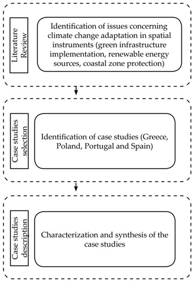
Figure 1.
Separation of issues and case studies for research purposes.
Based on the literature review, key issues were identified (in the different systems) that link spatial planning to responses to climate change. The issues of renewable energy sources, green infrastructure, and flood risk response have been the subject of numerous studies. In this article, however, we attempt to analyse them together from a specific shared perspective. We relate them to the institutional challenges of spatial planning instruments. The sequence of the work was as follows:
- Analysing the literature on the subject and identifying key issues in each country concerning the relationship between spatial planning and responses to climate challenges;
- Extracting key issues that could be collated from the perspective of the studied countries;
- Preparing questionnaires with specific questions (concerning the individual countries studied);
- Each author prepared answers concerning the case study of their country;
- Compiling answers and conducting a clarifying consultation;
- Compiling the results and presenting a discussion.
The authors, who specialize in the issues indicated above, identified specific case studies in their countries. The case studies were intended to address the relationship between a specific climate challenge and the spatial planning system. The authors identified the following as key thematic areas, observable from a country perspective, illustrating the link between spatial planning and climate challenges:
- Renewable energy investment projects (Greece and Poland);
- Implementation of green infrastructure (Spain and Portugal);
- Coastal zone protection (Spain).
The classification does not, of course, mean that other climate challenges are not noted in a particular country. However, according to the authors, these are the challenges that are particularly relevant in terms of their countries’ spatial planning systems. Within a given case study, the response of a specific spatial planning instrument (or the need to respond) to a given climate challenge should be presented. Depending on the situation, this could involve either legal changes (broadening the content of a particular instrument or introducing a new instrument) or changes in planning practice (e.g., local authorities applying a particular instrument in a new way).
In constructing the survey, the authors addressed the following issues:
- Examining the characteristics of local/regional/national spatial plans in their country, i.e., whether they are legally binding, whether they are mandatorily enacted, and what their content is.
- Characterizing other instruments relevant to the specific climate challenge (e.g., climate change adaptation plans, sectoral strategies, etc.). The instruments of concern were those related to spatial planning.
- Characterizing how the spatial plan in the case study was adapted to the climate challenge in question (legally/practically).
- Describing the consequences of this change, i.e., whether it is having an effect.
The case studies were presented in such a way as to most adequately cover the specific issue and the problems involved. The focus is on the national scale in Greece, a regional case study in Spain, and case studies of municipalities in Portugal and Poland.
The case studies were presented primarily from an issue-based perspective (relating to the topic of the article). Thus, the following sections were distinguished in the results:
- Characterization of the key features of the spatial planning systems of the countries studied and justification of the way in which a particular case study is presented (the associated planning scale and types of spatial planning instruments).
- Characterization of the specifics of spatial planning concerning the selected themes.
The questions contained in the first, basic questionnaire (Appendix A) allowed detailed topics of comparison to be identified. It should be pointed out that a very similar way of making comparisons was adopted in other publications [41]. Comparing solutions across countries requires a multi-stage approach. This method of comparison was also used by Alterman [52], whose approach was to identify key issues for the co-authors, followed by detailed verification of the answers and their consistency. Regardless of the methods of comparison used in other publications, we believe that for any publication comparing certain aspects of spatial planning, the authors need to adapt the specifics of the comparisons on their own. This is because the need to adjust particular issues in different countries may vary. In our opinion, the methods of comparison used in this article are sufficient for the purpose. In presenting the case studies of their countries, the authors relied on (1) knowledge of the national literature and legal conditions, (2) detailed analysis of legal acts, and (3) detailed analysis of the identified spatial planning instruments. Combining these three aspects, the authors answered the questionnaire.
An analysis of the literature on the subject leads to the conclusion that it is possible (and legitimate) to compare diverse and often disparate national spatial planning systems [53]. It seems crucial to precisely define what we expect from a particular comparison. Against this background, the possibility of comparing national spatial planning systems in Europe is not in doubt [39,54]. Thus, the possibility also exists when we juxtapose countries from different planning families. The above principle, therefore, applies to the possibility of comparing Poland with countries in the Napoleonic planning family. In fact, it can be shown that most of the features of the Napoleonic and Central European planning families are similar. This concerns the role of spatial plans as legal acts, the perception of the tasks of local government units, the regulatory sphere in planning, and even the defined objectives of spatial planning systems [55,56]. Ultimately, the differences lie in the degree of implementation of the defined goals and objectives. Countries in the Central European family have more barriers and difficulties [57,58,59]. All of this does not make comparisons impossible; on the contrary, it makes these comparisons more necessary and relevant.
The selection of specific issues from the country perspective should also be justified. This was the first stage of the analysis. In the course of the work on the literature review, it was established that on one hand, it is possible to discuss the response of spatial planning (including spatial planning instruments) to the challenges of climate change. On the other hand, it has to be stressed that climate challenges are identified somewhat differently from country to country. It should also be borne in mind that the focus of the article is on translating some general guidelines into concrete national institutional solutions. Collectively, therefore, a distinction was made between those issues that are recognized in the academic discussion of spatial planning systems in each country and those that are translated into institutional solutions. In each case, the identified and country-specific issue is the result of in-depth reflection by each author [59,60,61,62]. The authors do not exclude discussions on the importance of particular climate issues in their national systems. However, they express their conviction that the selected issues in each case meet these criteria to the highest degree.
3. Results
3.1. Basic Characteristics of the Spatial Planning Systems of the Studied Countries
This section presents the features of the spatial planning system of the studied countries that are particularly relevant to the purpose of the work. Of course, this is not an exhaustive characterization of those systems. The authors primarily focused on identifying, for each country, the levels of spatial planning, the real importance, and the key spatial planning instruments. The purpose of the study and the research questions posed first require a characterisation of the basic features of each of the national spatial planning systems studied. Only by isolating such characteristics will it be possible to answer the first research question and create answers to the next research questions.
In Greece, Law 2742/1999 (Spatial Planning and Sustainable Development) [63] initially fostered the principles of sustainable development at all spatial planning levels and defined two levels of spatial planning. The first level, the national planning level, includes the General Framework for Spatial Planning and Sustainable Development (GFSPSD) and the Special Frameworks for Spatial Planning and Sustainable Development (SFSPSD), which includes directions for land use planning that are binding. The second level includes the Regional Frameworks for Spatial Planning and Sustainable Development (RFSPSD), which are in line with the direction of the frameworks at the national level, while complementing and specifying the directions at the regional level. The RFSPSD was instituted in 2003–2004 [35], and all of these frameworks have since been revised.
The spatial and urban planning reform was initiated with Law 4269/2014 (Spatial and Urban Reform—Sustainable Development) [64], which was further amended with Law 4447/2016 (Spatial Planning—Sustainable Development and Other Provisions) [65] and Law 4759/2020 (Modernization of Spatial and Urban Planning and Other Provisions) [66]. These laws refer to the overall restructuring and simplification of the spatial planning system and the hierarchy of spatial plans. The existing structure of the Greek spatial planning system includes three levels [67] based on Law 4447/2016 as amended by Laws 4685/2020 and 4759/2020: (i) the national level, with a nonbinding visionary strategic plan consisting of the National Strategy for Spatial Planning and the Special Spatial Planning Frameworks; (ii) the regional level, with spatial and regional plans consisting of the Regional Spatial Planning Frameworks and the Maritime Spatial Planning Frameworks; and (iii) the local level, with regulatory urban plans consisting of local spatial plans, special urban plans, and implementation urban plans.
In Spain, the regional level is the key level in the spatial planning system [68,69]. The Autonomous Communities approve the territorial planning laws and oversee approval of territorial plans, which can be integrated (i.e., regional or subregional strategies or master plans) or sectoral (planning for a sector, such as energy, coastline, risks, and landscapes, with territorial incidence). For the purposes of territorial planning, the state administration is limited to the approval of land laws, which the Autonomous Communities then adapt to their territories. The regional administration is joined by the local (municipal) administration, which has the power to prepare and execute municipal urban plans for territorial planning within its administrative scope [70]. Administrations at other scales (subregional and supra-local) also have a role in those Autonomous Communities. Thus, it is normal for Autonomous Communities to approve territorial plans (strategies, plans, guidelines) at a regional scale and subsequently draw up plans at a lower scale, generally regional, to elaborate on territorial planning proposals at that scale. In this way, administrations at the local scale (municipality) find close references to better delimit and specify their land needs in municipal urban plans.
In Spain, there is a rich tradition in urban planning that dates back, in the modern sense, to the 19th century, with “Ensanche” plans in many cities. On the contrary, actions regarding spatial planning are recent, limited to the last four decades. The Urban Law of 1956 inaugurated the modern period of land use planning. Until the 1980s, land use planning was understood as involving sectoral policy at the service of urban planning. From then on, with the transfer of power in matters of urban and territorial planning to the Autonomous Communities, it began to be conceived as an interconnected, integrated policy for regional spaces [68]. Therefore, the Autonomous Communities are assigned all power in matters of spatial planning. They are obliged to draw up laws and spatial plans. In addition, they are in charge of ratifying the approval of municipal urban plans. It is necessary to point out the change that occurred in the guiding principle of spatial planning in Spain, from “economic growth” and the allocation of land for housing, equipment, and infrastructure without any criteria regarding environmental impact (1980s and 1990s) to “territorial sustainability” with the approval of the European Spatial Development Perspective [42] and the landscape agreement.
In Portugal, the spatial planning system is composed of two primary territorial tools, known as plans and programs. Among them, only plans are legally binding for private entities, whereas programs hold authority over public administration [70,71,72]. The system is divided into four levels of intervention and action: national, regional, intermunicipal, and municipal [71,73,74]. Civil parishes are not included in this system because of their small size and limited authority [75]. The National Spatial Planning Policy Program (PNPOT) [76] is the sectoral program at the national level that governs the spatial distribution of government strategies for socioeconomic development, including the allocation of significant national public investment projects [77]. At the regional level, regional programs are established for NUTS II areas addressing issues such as the urban system structure, regional infrastructure, environmental protection, and cultural heritage preservation [78,79]. The intermunicipal and local levels constitute the last two levels of the Portuguese framework of territorial planning and management. The former involves collaboration between two or more municipalities on a voluntary basis, whereas the latter involves the creation of a comprehensive municipal master plan, which is mandatory for all municipalities [71]. This legally binding document sets out the spatial development strategy, spatial planning policies, urban policies, and spatial organization model of the municipality [74,75]. The municipal master plan, along with other plans developed by municipalities, must be consistent with the regional program and programs established by the central administration [71,73].
The Polish spatial planning system has three levels: national, regional, and local. The latter is key, i.e., municipalities are recognized as key actors in spatial planning. This is related to the legal framing. At the national level, there is no strategic act linked to spatial planning. The Concept for the Spatial Management of the Country, which went into force several years ago, was cancelled. Work on another document is under way, but it is causing much controversy [51]. At the regional level, the spatial planning instrument is currently still represented by voivodeship spatial development plans. However, they have no binding force and do not set out detailed zoning and land use guidelines. They basically duplicate some of the findings of other acts (e.g., on forms of nature protection). Their only important element is the identification of supra-local investments for public purposes (which must be included in municipal documents). At the local level, there are two spatial planning instruments. The first is the study of spatial development conditions and directions. As the name suggests, they define the municipality’s spatial development concept, but they are not generally binding acts (instead, they must be compulsorily enacted). Local spatial development plans are generally legally binding. They specify the use of land and the rules for its development. However, municipalities are not obliged to adopt these plans, and as a consequence, plans are not in force in most parts of the country [51]. Their equivalent then becomes administrative decisions issued at the request of the investor, that is, decisions on development conditions. This situation exacerbates spatial chaos, leading to uncontrolled development and numerous abuses [54,55].
Table 1 shows the key features of the spatial planning systems studied, relevant to the purpose of the thesis and the research questions.

Table 1.
Key features of the national spatial planning systems studied.
The systems studied are similar to each other in many respects. First of all, there is a very similar perception of the role of spatial plans at the local level (legally binding acts that zone the land and define the rules for its development). There are also different levels of planning in each country. However, the results in Table 1 show that supra-local planning levels play a more serious role in Greece and Spain. In each of the cases studied, the basic spatial planning instruments do not contain a specific response to the climate challenge (which answers the first research question).
The next stage of the analysis was to answer two further research questions. This required the identification of sectoral instruments for spatial planning, adapted to the climate challenge, in each of the countries studied. However, it must be stressed that due to the specificities of each of the countries studied, in each case, the description of the instrument in question is adapted to the realities of the country in question.
3.2. Spatial Planning Responses to the Challenges of Climate Change Adaptation
3.2.1. Renewable Energy Sources and Spatial Planning at the National Level: A Case Study of Greece
In Greece, there is a separate legislative framework called the Special Framework for Spatial Planning and Sustainable Development for Renewable Energy Sources (SFSPSD-RES) (MEECC, 2008) [80,81], which is based on Law 2742/1999. A revised version is expected by the end of 2023, which will be in the form of a special spatial planning framework based on Law 4447/2016 [65]. The SFSPSD-RES is a sector-specific national spatial plan that includes technical rules and siting criteria for the deployment of renewable energy projects (windfarms, small hydroelectric, photovoltaic, biomass/biogas, and geothermal projects).
The analysis below concerns wind farm projects. Regarding the deployment of wind farms, the Greek territory is divided into three wind priority areas (WPAs) with high wind potential and wind suitability areas (WSAs) that include the rest of the country. The WPAs are located in Northern Greece (regions of Eastern Macedonia and Thrace), in the prefectures of Evros and Rodopi; in Central Greece (regions of Central Greece, Western Greece, and Thessaly), in the prefectures of Viotia, Fthiotida, Fokida, Evritania, Evia, Aitoloakarnania, and Karditsa; and in Peloponnesus, in the prefectures of Arcadia and Laconia. In addition, based on its unique spatial and environmental qualities, and exploitable wind potential, the national territory is divided into the following broad categories: (i) mainland, including Evia; (ii) Attica, which stands alone as a special category of mainland due to its metropolitan character; (iii) the inhabited islands of the Ionian and Aegean Seas, including Crete; and (iv) the offshore marine area and uninhabited islets.
The SFSPSD-RES suggests a maximum land coverage for wind farms that ranges from 4% (in municipalities with high tourist development) to 8% (in WPAs of primary local authorities and in the region of Attica).
The deployment of wind farms should be excluded from the following [81]:
- Areas with monuments declared to be World Heritage sites and other monuments of major importance, as well as archaeological protection zones;
- Areas with absolute nature protection;
- Cores of national parks, monuments of nature, and aesthetic forests;
- Wetlands of international importance (Ramsar Wetlands);
- Natura 2000 protected areas;
- Urban areas and settlements established before 1923 and areas with fewer than 2000 residents;
- Tourist areas, areas with establishments of organized development of productive activities in the tertiary sector, theme parks, and tourism ports;
- Sandy beaches and coastal swimming areas;
- Marble quarries and mining areas;
- Other areas or zones that fall under a special land use regime where the siting of wind farms is not permitted.
Annex II of the SFSPSD-RES specifies the distance of wind farm installations from neighbouring land, activities, and technical infrastructure networks. There are cases where an absolute minimum or maximum value exists and others where the distance is defined either by a special study, such as an environmental impact assessment, or by a relevant authority. In addition, the SFSPSD-RES includes two criteria for integrating wind farms in the landscape: (i) the overall density of the wind turbines and (ii) the visible horizon covered by the turbines of a rotating 360-degree observer who is standing at the location of interest [81,82].
There is also the National Energy and Climate Plan (NECP) [83], the Greek government’s strategic approach to energy and climate challenges, which lays out a thorough roadmap for achieving particular energy and climate goals by 2030. The NECP establishes specific targets for Greece’s greenhouse-gas emissions in 2030 and determines the country’s energy mix to that point by boosting the use of renewable energy sources and natural gas [83], as well as energy efficiency. The NECP also analyses the investment requirements and the many implications for society, the economy, and the environment, analyses the evolution of the Greek energy system up to 2030, and identifies the policies and measures required to achieve these goals [84]. Apart from the NECP, there are also Regional Plans on Climate Change Adaptation (RPCCAs). Each RPCCA is a comprehensive plan that identifies and prioritizes the necessary measures and actions for the region under study to adapt to climate change. As such, it analyses in depth the necessary sectoral policies and determines the feasibility of individual measures and adaptation actions at the local/regional level. The plan identifies and prioritizes the necessary adaptation measures and actions for a period of seven years.
Wind farms and photovoltaic arrays, which are regarded as the most developed and competitive applications in terms of their impact, are the predominant RES power production applications that will help in achieving the targets in the next decades. The SFSPSD-RES is the legislative tool that sets the restrictions regarding RES siting. In addition, the Regional Spatial Planning Frameworks can propose either a wider RES development zone or actions for mitigation of and adaptation to climate change. Notably, the Regional Spatial Planning Framework of Central Macedonia proposes additional WPAs and enhances the strength of applying the best available practices and technologies to increase energy efficiency, the on-site integration of RESs, and the co-generation of energy in all sectors (public administration, housing, industry, transport) in accordance with the national commitments arising from relevant international and European climate change policies.
The implementation of the SFSPSD-RES has had positive effects on the spatial planning of RESs. Specifically, regarding wind energy, at the end of 2021, a total of 374 wind farms with a minimum of 1 and a maximum of 41 wind turbines were identified, distributed among the 13 administrative regions (ARs) of the country (Hellenic Wind Energy Association). It should be noted that the majority of wind farms (81.4%) that have been deployed since 2008, when the SFSPSD-RES was implemented, are sited in areas compatible with the SFSPSD, showing the effective application of the legal framework. The deployment of wind farms within the boundaries of Natura 2000 protected areas is the main reason for improper siting. However, RES projects can be deployed in protected areas if an environmental impact assessment (EIA) and a specific ecological assessment (SpEA) are performed.
It should also be noted that there are numerous studies in the literature that use the aforementioned legal instrument to propose either suitable or sustainable sites for onshore wind farms in Greece at various spatial planning scales [85,86]. Tegou et al. [87] developed an integrated framework for selecting the most appropriate sites for wind farm deployment on an autonomous independent island in Greece (Lesvos Island, Aegean Sea), considering the limitations imposed by the SFSPSD-RES. In order to support strategic spatial planning for a Greek island (Crete), the SSFSPSD-RES was employed as a fundamental instrument to conduct a thorough evaluation and prioritize regions for site selection of sustainable wind farms at a regional level. This involved the use of a number of exclusion criteria for ensuring minimum distances from neighbouring uses or activities, and technological infrastructure networks. Considering several planning and environmental criteria, Latinopoulos and Kechagia [88] provided a methodology for the systematic assessment of site suitability for wind farm development at the regional level (Regional Unit of Kozani, Prefecture of Western Macedonia). Panagiotidou et al. [89] used the Greek legislation and the international literature to identify potential sites for wind farm deployment in the Dodecanese Islands. The SSFSPSD-RES has also been used to exclude inappropriate sites. The process followed by Bili and Vagiona [85] for wind farm siting on the island of Andros, Greece, was initially based on an exclusion approach based on the SFSPSD-RES regulatory framework. Bertsiou et al. [86] used the SFSPSD-RES to highlight eligible sites for wind turbines in Fournoi Korseon (a cluster of islands in the eastern Aegean Sea). Feloni and Karandinaki [90] presented a GIS-based multicriteria decision-making technique to determine the suitability of wind farms in Chania Regional Unit.
3.2.2. Climate Protection with a Special Focus on Coastal Zones: A Case Study of Spain
The Valencian Community, located on the Mediterranean coast of the Iberian Peninsula in the Spanish state, occupies a prominent position among the Autonomous Communities with regard to the development of territorial planning policies [68,91,92]. It has promoted some successful plans that can be presented as examples of good practice, such as the Valencian Spatial Planning Strategy [92] and the Territorial Plan for Coastal Planning [93]. In four decades of autonomy, territorial planning actions have gone through successive phases of interest on the part of governments, with stages of promotion and of manifest abandonment when considering the spatial planning policy as an obstacle to the promotion of real estate. However, only since the approval of the Territorial Strategy of the Valencian Community in 2001 has it been possible to speak of a determined impulse on the part of the regional administration with regard to spatial planning. The last step was the approval of the new Territorial Planning Law in 2015, by which the protection of the landscape and the use of green infrastructure became the main tools of territorial planning [69]. The scalar hierarchy of planning in the Valencian Community includes the Valencian Spatial Planning Strategy at the top, as the main document at the regional scale for the planning of the territory. In the second position are Territorial Action Plans, which can be of two types: integrated (subregional) or sectoral (coastal, natural risks). This scalar hierarchy is completed by strategic territorial actions and municipal urban plans, with their two categories of management, structural and detailed.
The greatest achievement has been the approval and development of the Valencian Spatial Planning Strategy [92], a basic reference framework on a regional scale for regulating the process of assigning new land uses [94]. This regional spatial strategy raised the quality of the principles of sustainability in territorial planning after a few years of enormous territorial transformation during the decade of the real estate bubble (1998–2008). To this end, 25 main objectives and 147 guidelines were developed [95]. Two fundamental contributions to the future management of the Valencian territory stand out among the voluminous content of this document (30 thematic notebooks): (1) determining green infrastructure and the landscape as the main elements of territorial structuring and the allocation of new land uses and (2) establishing a set of criteria for the growth of residential land, which has become the basis for the control of real estate expansion in the Valencian territory. In this regard, the strategy includes land occupation indices for economic activities and specific criteria for residential land occupation and economic activities in rural municipalities.
In addition, the Valencian Spatial Planning Strategy includes guidelines for incorporating aspects related to mobility, natural risks, climate change, water, housing, energy, logistics, and innovation in territorial and urban planning. A prominent role is given to the public participation process, which must become a core element of planning. The spatial strategy currently in force continues to be the main reference document for the regulation of territorial planning processes at the regional scale, with effects seen at lower scales (subregional and local). Since its approval in 2011, changes have not been warranted, although in the intervening years, the Department of Territory (regional administrative government) has been under strong pressure to modify the maximum rate of land occupation for residential use on the Valencian coastline by the economic sectors related to real estate development (Figure 2).
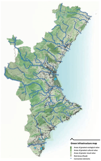
Figure 2.
Green infrastructure map of Valencian Community. Source: Valencian Spatial Planning Strategy [68].
The Valencian littoral is a geographic space with great tension due to the demand for land to transform it for urban–tourist uses and infrastructure [68]. For this, the regional administration has developed a sectorial territorial plan to protect the few free spaces that remain on the Valencian coast from urbanization. It is called Territorial Action Plan of Green Infrastructure of the Valencian Littoral (PATIVEL). The PATIVEL, approved in 2018, is a typical example of an instrument used for the protection of a fragile and rare space, where diverse and often conflicting uses and interests converge. Hence, there is a need to address its management based on the principles of conservation and sustainable management and within the framework of new criteria for land use planning, since it is based on the concept of a green infrastructure plan, a basic work tool in territorial planning in different countries and regions of the world [96]. The PATIVEL is based on recommendations by the European Parliament and the council on the integrated management of coastal zones to guarantee the control of urbanization while respecting the natural characteristics of the coastal environment. It is also included in the Climate Change Adaptation Strategy of the Spanish coast (Government of Spain), whose proposals include the necessary regulation of coastal land use and adaptation to climate change [97].
The PATIVEL protects a total of 7500 ha of the region’s coastline and integrates 12% of the land that has not yet been urbanized in a 500-m strip from the inner limit of the seashore (Figure 3). The land that remains protected includes, in addition to environmentally catalogued spaces, a few stretches of the coastline that remain unoccupied for urban purposes, do not have an approved urban plan, or are in the process of development [96].
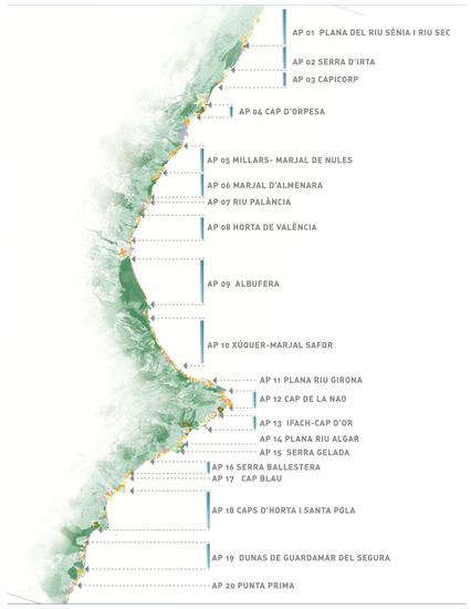
Figure 3.
Protection areas on Valencian coast included in PATIVEL. Source: PATIVEL.
The PATIVEL establishes two types of urban land in the littoral area: (a) land not suitable for coastal protection development (0–500 m inland) and (b) land not suitable for coastal reinforcement development (500–1000 m inland). In the first one, new buildings are not allowed, but the rehabilitation and adaptation of existing ones for residential and tertiary uses related to tourism is allowed. In the second one, tourism camps, space for open sports that do not involve the construction of homes, fuel supply stations linked to communication routes, and hotel and care establishments with low occupancy of the land and rural environment may be authorized.
The PATIVEL even proposes the declassification of developable land without an approved program, the plan’s most innovative and controversial aspect (Appendix B). The protection of these protected areas [98] should incorporate landscape plans, as well as joint management measures between regional and local administrations, and even agreements with landowners for the conservation and management of unique areas that have become part of the coastal green infrastructure. Another option for the future would be for the regional administration to carry out purchase plans for protected land, following the model of other countries.
3.2.3. Implementation of Green Infrastructure for a Resilient and Sustainable Territory: The Case of Setúbal, Portugal
Setúbal is a municipality situated in Lisbon Metropolitan Area, located 25 km south of the city of Lisbon and covering an area of 23,033 km2. According to the 2021 Census, the population of Setúbal was approximately 123,496 inhabitants [99]. It is surrounded by the municipalities of Palmela to the north–northeast, Sesimbra to the west, and Barreiro to the northwest. Setúbal is a significant urban centre in the greater metropolitan area due to its population and excellent transportation connections to Lisbon and other main cities and regions of Portugal. It is considered an essential economic centre of the country, with numerous infrastructures and facilities located along its coastline [100]. Setúbal’s complex territory combines urban and rural features, making it extremely vulnerable to climate risks such as floods, overtopping, tsunamis, coastal cliff erosion, and urban heat islands [101]. Bearing this in mind, the municipality of Setúbal has developed a green infrastructure plan in order to protect the ecological system and promote risk management of the municipality, increasing its resilience and sustainability (Appendix C).
As stated by numerous authors, the definition of green infrastructure in the literature is complicated, resulting in various approaches and planning strategies. The literature employs various terms, such as greenways, ecological networks, and green corridors, to describe the same concept, green infrastructure, and in Portugal, this is also the case. In 1987, the term “continuum natural” was introduced and legally defined as green infrastructure in the Portuguese Environmental Policy Act, which focused on sustainable development, natural resource optimization, and preservation. This act established a mechanism to safeguard the “public right to a human and ecologically balanced environment” and the state’s obligation to promote the act through individual and collective efforts. However, the concept of green infrastructure was only officially introduced in Portuguese legislation in 1999 through Decree-Law 380/99, the legal framework for territorial management instruments that established land classification and qualification criteria, as well as technical concepts for territorial management and urban domains. With the approval of Decree-Law 380/99 [102], all municipalities were required to delimit green infrastructure at the municipal level. Nevertheless, it was only in Regulatory Decree 9/2009 that the technical concept and the areas that should be part of green infrastructure were defined. According to this decree, green infrastructure, referred to as municipal ecological structure, is “a collection of areas that, due to their biophysical, cultural, and landscape characteristics, ecological continuity and structure, contribute primarily to the ecological balance, protection, conservation, environmental assessment, landscape, and natural heritage of rural and urban areas” (Decreto Regulamentar No. 9/2009|DRE; no date) [103].
In the Portuguese spatial planning framework, green infrastructure is integrated within the master plan, a legally binding document, at the municipal level. Green infrastructure also consists of other legally binding components, such as the national agriculture reserve, national ecological reserve, and public water domain (RAN, REN, and DPH, respectively), according to Portuguese law. Public green spaces and other areas necessary for maintaining environmental balance and protecting natural heritage, such as those supporting hydrologic cycle regulation, bioclimatic regulation, air quality improvement, and biodiversity preservation, are part of green infrastructure within urban boundaries.
The green infrastructure plan of Setúbal was developed in accordance with the Portuguese legal framework in force and acts as a management tool for ecological systems within the municipality, promoting sustainable development and ensuring the conservation of natural resources. This infrastructure consists of different areas that contribute to the ecological balance of the territory, including rural and urban spaces; spans over 91% of the municipality; and comprises two structures, fundamental green infrastructure and urban green infrastructure (Figure 4) [104]. The former covers 81.7% of the territory and protects areas essential for natural system functioning, while the latter covers 9.5% and was designed to improve ecological processes in built-up areas [101].
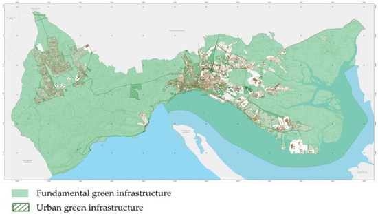
Figure 4.
Green infrastructure of Setúbal (fundamental and urban) (source: Ferreira et al. [80]).
Setúbal’s green infrastructure plan covers spatial systems with recreational, production, and protection functions. As a tool for environmental planning, the GI plan of Setúbal is aimed at protecting natural resources, regenerating environmental systems, and integrating with higher-level spatial planning instruments, such as regional and national plans. In addition, this instrument is intended to promote the sustainable development of the territory through the compatibility of urban and rural uses with the integration and enhancement of the natural, cultural, and landscape heritage, as well as the requalification and regeneration of spaces of high environmental value. This objective also unfolds into concrete objectives that are divided into three large groups: the guarantee of ecological functions, the preservation and enjoyment of cultural and natural heritage, and the development of national and sectoral strategies at the local level.
The green infrastructure of Setúbal does not constitute an easement or restriction of public utility. As a planning instrument, the GI plan has a regulatory and propositional aspect, aimed at protection and concession among systems, and a multi-scalar aspect, aimed at integrating the different scopes of the instruments of territorial management. In addition to safeguarding the existing ecological systems, it also allows the creation of new ecological units that can give continuity to the structure, either through networks of municipal green corridors and large inter-municipal ecological corridors or, at a more local level, with the creation of green areas for recreation and leisure, and protected and framed green areas.
Due to Setúbal’s unique coastal location, it is highly vulnerable to various climate change risks, such as earthquakes, floods, tsunamis, overtopping events, wildfires, overheating, droughts, and storms [104]. However, not all areas are covered by land management instruments and restrictions, leaving urban areas, which are the most vulnerable to risk, unprotected. The green infrastructure plan is the only municipal planning instrument that considers the preservation of ecological functions and the promotion of local strategies to reduce risks in urban areas.
3.2.4. Lack of Consideration of Climate Objectives in Spatial Planning (with Particular Reference to Renewable Energy Sources): A Case Study of Poland
In Poland, there is a distinct lack of spatial planning solutions directly aimed at achieving climate goals. From this perspective, planning issues for coastal zone protection are not significantly addressed. The concept of green infrastructure is discussed in practice but in isolation from the legal framework [29]. In the institutional sphere, only the relationship between spatial planning and the thematic areas concerning the implementation of renewable energy sources is noticeable. In addition, sectoral solutions are also lacking here. The description of the case study can, therefore, be reduced to the following:
- An analysis of the legal solutions (at the central level) concerning the spatial aspects of renewable energy implementation;
- An analysis of the content of the exemplary spatial plan.
National Level
As mentioned above, there are no spatial plans in Poland other than at the local level. It should be added that the Polish case study is a decidedly negative example. Despite the extensive content of spatial plans, their provisions on renewable energy sources are not extensive. There is only an indication in the Spatial Planning and Development Act that a local plan providing the possibility of locating buildings also allows the location of micro-installations in the case of land use other than production, unless the provisions prohibit the location of such installations [105,106]. This is tantamount to saying that it is not necessary to include micro-installations (of renewable energy sources) in spatial plans. Micro-installations can be realized regardless of the content of the spatial plan.
The situation is different for wind power plants. According to the special law on investments in wind power plants, such an investment can only be developed on the basis of a spatial plan. Recall that municipalities do not have to adopt spatial plans. Therefore, if a municipality decides not to adopt a spatial plan providing for a wind power plant, such an investment will not be developed. In addition, the enactment of a spatial plan for a wind power plant is subject to strict reservations. It is only possible to adopt such a plan if the wind power plant is situated more than 700 m from a residential development (until recently, the distance was even greater, amounting to 10 times the height of the wind turbines). The guidelines for a plan providing for the siting of wind turbines are as follows:
- It should specify the maximum overall height of wind turbines.
- It should at least be drawn up for an area where no new residential buildings or buildings with mixed functions may be located.
The explanatory memorandum accompanying the draft resolution on the preparation of a local plan providing for the location of a wind power plant should contain, in particular, the maximum overall height of the wind power plant to be determined in that plan [107,108]. Guidelines formulated in this way have prompted reluctance on the part of municipalities to adopt plans for renewable energy sources for many years. The consequence is a very poor level of implementation of these investments in Poland [107].
Local Level
Specific examples of municipalities and their approaches to spatial plans should be used as a basis for assessing individual practices. For example, the municipality of Międzyzdroje (in the northwest of Poland) takes a varied approach to the issue of renewable energy sources in spatial plans. The scope of planning prohibitions may be associated with prohibiting the location of any wind energy facilities. This type of prohibition is correct from a formal and legal perspective; however, it may provoke a discussion on the legitimacy of such general planning decisions. It should be emphasized that it also covers appropriate micro-installations (all the more so, as other conditions are required for wind power plants specified in the act on the execution of investments in wind power plants). The scope in which the possibility of realizing diverse renewable energy sources is allowed is much broader.
Another part of the provisions is concerned with the parts of the plans that define the rules for expanding/upgrading heat supply systems. In these cases, heating systems that “use renewable sources” are permitted. This is a very broad inclusion. Sometimes, in order to eliminate possible doubts, key types (heat pumps and solar collectors) are specified. This framing can sometimes provoke a divergent approach to the interpretation concerning other (not explicitly mentioned) devices. The authorization of photovoltaic cells on the roofs of buildings can also be singled out. In the international discussion on the role of renewable energy sources in spatial planning, the appropriateness of such detailed regulations (from a systemic perspective in terms of national legislation) is considered. The prevailing voices are inclined to support eliminating the obligation to introduce such guidelines. There is currently no such obligation in the Polish system. One more direction should be noted, related to determining the possibility of siting structures/facilities in a given area, concerning the extraction and use of geothermal energy. It is important to emphasize the preservation of other functions of the area in question (e.g., those related to green areas).
4. Discussion
The aim of this work is to identify how spatial planning instruments support selected objectives related to climate change adaptation. The analysis shows that such support from spatial planning instruments exists in three of the countries studied. However, such support is lacking in the Polish system. At the same time, in all systems, the basic (classical) spatial planning instruments do not contain an adequate response to the climate challenge. Therefore, in three of the countries studied, sectoral instruments were drawn up (in different, distinct ways). The key is that spatial planning complies with a scalar hierarchy, so that the higher scales (state or regional) have priority over the local scale, when developing the actions established in the plans. Thus, state or regional scale plans must contain the main determinations and measures for adaptation to climate change, which must be developed in detail in local (or supra-local) scale urban plans.
In principle, therefore, it is not sufficient to use solutions linked to spatial plans at the local level to effectively integrate climate change adaptation objectives into spatial planning [49]. Land zoning at the local level or simple restrictions on land use introduced in spatial plans are obviously an important dimension. However, this will not be sufficient without the support of other solutions. Indeed, municipalities can and do impose spatial restrictions on selected climate change adaptation targets to varying degrees. Very often, they may succumb to pressure from communities or individual investors who are reluctant to do so [20]. Therefore, support from higher planning levels and sectoral instruments is indeed important. It should also be stressed that the climate challenges in the studied countries (except Poland) significantly limit the autonomy of municipalities in spatial planning. In many national spatial planning systems, this principle is considered very important. However, it cannot be treated absolutely. The presented case studies lead to the conclusion that climate change adaptation objectives provide a justification for more serious interference by supra-local authorities in spatial planning. However, this demand cannot be understood as being directed at deepening centralization. Nevertheless, in most countries, there are thematic aspects that are shaped to a directional extent at higher levels of public authorities (e.g., directional solutions for environmental impact assessments, delimitations of forms of nature protection, delimitation and protection of historical monuments, etc.). Undoubtedly, key objectives related to climate change adaptation belong to this group [16].
Intervention from the perspective of national authorities can vary in practice. One example is a sectoral plan on renewable energy planning in Greece adopted at the national level. An important solution included in such a plan is to delimit areas with specific opportunities for the realization of renewable energy sources nationally. Such a plan would take various steps to define the rules for locating renewable energy sources: defining investment exclusion zones and indicating (in other areas) the maximum land coverage by investments, defining the distance from wind farms to other investments, and defining criteria for integrating wind farms into the landscape.
From a national perspective, green infrastructure solutions in Portugal are also relevant. The implementation of green infrastructure is different from the implementation of renewable energy sources. Nevertheless, both issues are significantly linked to climate change adaptation objectives. The implementation of green infrastructure in Portugal is also based on national-level solutions that explicitly bring this institution into the legal sphere. This includes defining green infrastructure and relating it to specific areas on a national scale. However, in Portugal, green infrastructure is effectively developed and implemented in the spatial plans at the local level, as illustrated by the case study presented above. The planning approach is to link green infrastructure to the designation of individual sites. Evidently, however, the support of national and regional instruments is crucial in this context, since they are the spatial plans that provide guidelines about which areas should be preserved and protected and enable green infrastructure to be effectively integrated into planning at the local level.
The Spanish case study is different; there, the regional level is key. Identifying key (evolving) spatial planning objectives should be considered an appropriate solution. From a regional perspective, identifying the extent to which specific (climate-important) land is allocated for housing and economic development should be considered important. Again, this provides a serious point of reference for the spatial planning framework at the local level. The sectoral instrument on the coastal zone deserves a separate mention. This special plan explicitly classifies land from the perspective of buildability (introducing two categories of land) and even proposes, for certain cases, the declassification of land that was previously considered suitable for development.
The different nature of the introduction of development restrictions or specific types of zoning between sectoral instruments and traditional spatial plans is noteworthy [41,109]. In these cases, specific restrictions and guidelines result from in-depth sectoral analysis (this is not always the case in traditional spatial plans). At the same time, it is important to link the indicated solutions with those of the second group identified, i.e., non-standard solutions. In Greece, Spain, and Portugal, the solutions presented are different in detail but have important features in common: (1) interference by supra-local authorities in spatial planning and (2) the introduction of sectoral instruments in which land use restrictions, based on in-depth analysis, are combined with other, less standard solutions for spatial planning. In each analysed case, this has a positive effect spatially. It involves the smooth implementation of renewable energy investments (Greece), the effective protection and shaping of green infrastructure (Portugal), or the effective protection and development of coastal zones (Spain). Figure 5 provides a summary of climate protection considerations in the spatial planning of the studied countries.
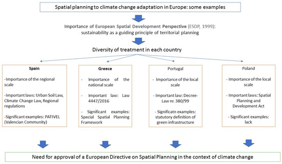
Figure 5.
Key determinants of climate protection in spatial planning from the perspective of the studied countries [42].
The article’s contribution to the discussion on spatial planning is an analysis of different sectoral spatial planning instruments in different countries that respond to climate challenges. It is shown that traditional spatial planning instruments generally do not contain solutions that are particularly relevant to climate challenges. The role of supra-local spatial planning instruments was also demonstrated. This should be considered a novelty of our research. Norman indicated that local perceptions of climate challenges are not enough [1]; however, she did not relate this reflection to specific spatial planning instruments. A similar approach is lacking in studies on methodologies for comparing spatial planning systems [3]. Such studies lack an in-depth analysis of the role of spatial planning instruments from the perspective of climatic challenges [39,41]. Where the link between climate challenges and specific instruments was analysed, this was performed primarily with reference to a single country example [4,12,27,36]. At the same time, the studies did not provide a broader account of the different climate challenges and their translation into the transitional planning instruments of different countries. On the contrary, the focus has been on individual challenges [28]. There is also a lack of emphasis on the role of strategic spatial planning in addressing climate challenges [28]. It should also be added that from a more topic-specific perspective, the article fills in the research gaps. The topic of green infrastructure has been analysed at great length [62,97]. What is lacking, however, are analyses that, on one hand, treat green infrastructure explicitly as a response to the climate challenge and, on the other hand, include an in-depth reflection on the optimal institutional response of spatial planning to this challenge. More often than not, such an approach can be distinguished from renewable energy sources [105]. For this topic, a certain barrier is the comparison of the indicated climate challenge and other challenges.
Due to the importance of the effects of climate change on the European territory, the European Union should approve a directive on spatial planning that prioritizes these processes during the development of mitigation and adaptation actions and makes it possible to coordinate processes and work scales effectively in each member country. Likewise, this directive should oblige the EU countries, as the European Flood Directive (60/2007) [109] has done, to prepare a map of the effects of climate change on the territory (such as heat islands, main climatic risks, and sea level rise on the coast), which should be mandatory in the spatial planning processes carried out in all countries of the European Union. In any case, such a directive should force countries to make sustainability and climate change the main guiding principles of spatial planning in the European territory.
It should be stressed that the process of preparing sectoral instruments was somewhat different in Greece, Spain, and Portugal. In Greece, the key sectoral plan was introduced at the national level. This required a prior analysis of the feasibility of renewable energy investment in specific areas of Greece and the optimal ways in which it could be ensured with the spatial plan. The resulting sectoral plan contains the results of both types of analysis, directly tailored to the document. In Portugal, the key analysis covered how the concept of green infrastructure was formulated in the law. Thus, it was not a spatial analysis but a legal analysis (including the choice of specific wording). In Spain, the importance of the regional scale must be emphasized. The analysed strategy covers diverse issues, not only those related to the topic indicated above. In this case, therefore, it can be pointed out that the analysis related to the preparation of the regional strategy was based on the integration of development policies. The PATIVEL can be viewed differently. The plan contains both the results of sectoral analysis and regulatory provisions. It thus brings together the two aspects indicated above. In conclusion, it can be indicated that in the studied cases, the link between spatial planning and climate challenges relies on at least one of the above-mentioned activities:
- -
- Conducting in-depth sectoral analyses of the spatial challenges to implementing a particular issue and optimal institutional solutions.
- -
- Framing the issue in relation to other development objectives, i.e., integrating development policies.
- -
- Reflecting on how to frame specific issues in such a way that they are effectively translated into spatial planning.
This research adds to the body of knowledge concerning comparisons of spatial planning systems and the response of spatial planning instruments to climate challenges. In the literature, two ways of comparing planning systems can be distinguished: more synthetic (and consequently simplified) comparisons, covering more countries, and in-depth studies, covering fewer countries.
This research provides important insights into directions for adapting spatial planning instruments and addressing climate challenges. A key conclusion is that the involvement of supra-local authorities is necessary to properly support approaches to climate challenges in the spatial sphere. Supra-local instruments can ensure effective alignment of the spatial and climate challenge spheres. Of course, this thesis applies differently in different spatial planning systems. However, the experiences of the countries analysed in this paper lead to the conclusion that being limited to local solutions in the analysed scope is not enough. The authors consider this conclusion to be an important contribution resulting from this article.
5. Conclusions
In Greece, Spain, and Portugal, it was found that the traditional approach to spatial planning was not sufficient. Therefore, supra-local and sectoral instruments were developed to combine selected climate change adaptation objectives with spatial planning objectives. This contributed to significant support for the implementation of individual objectives. A different example is Poland, where no similar significant institutional arrangements were found. Consequently, the implementation of climate change adaptation objectives is moderately noticeable in the Polish spatial planning system.
The paper achieves the research objective by explaining how the spatial planning systems of the four countries studied address climate challenges. Barriers were identified: the weakness of “traditional” spatial planning instruments in this regard and the limitations of the local level of spatial planning (first research question). A possible way forward was identified, including sectoral spatial planning instruments (second research question). The integration of climate change adaptation objectives into spatial planning is an important and necessary task. At the same time, the study shows that effective integration of spatial planning and climate change adaptation goals is possible. An in-depth analysis of system options in each country seems necessary. On one hand, it must be borne in mind that there is always a risk of over-regulating a given system and incorporating solutions that are excessive in relation to the needs. On the other hand, adapting to climate change is one of the key priorities for all countries in the world. In addition, at least in most cases, the alignment of climate change adaptation objectives with spatial planning is very important and necessary. This justifies both the development of sectoral solutions and the more-than-standard intervention by supra-local authorities in spatial planning at the local level.
This article obviously has important research limitations. The main limitation is the diversity of national spatial planning systems. Therefore, the detailed description of each case study, as well as the way in which the selected spatial planning instruments are characterized, is different. The solutions look slightly different in each national spatial planning system. This applies not only to legal solutions but also to planning practice. Thus, the authors were able to collate comparable problems that exist in each of the studied countries. However, this article does not, of course, include all details of the functioning of the studied national spatial planning systems. This must be taken into account when trying to apply the conclusions to other national systems (which are also, in many respects, internally complex). Despite these obvious differences, it was possible to identify common, universal thematic elements.
The issues taken up in the article should be followed up. An important challenge is to analyse the approaches of spatial planning systems to climate change adaptation in other countries. However, this requires a very detailed analysis of both the systemic and constitutional conditions of each country and the features of its spatial planning system, as well as sectoral solutions. It may be particularly important to identify those countries in which climate change adaptation goals are primarily implemented within the framework of spatial planning at the municipal level and positive effects have been observed. In addition, climate change adaptation objectives other than those identified in the article require similar analysis.
Author Contributions
Conceptualization, M.J.N., R.M., J.O.-C. and D.G.V.; methodology, M.J.N., R.M., J.O.-C. and D.G.V.; software, M.J.N., R.M., J.O.-C. and D.G.V.; validation, M.J.N., R.M., J.O.-C. and D.G.V.; formal analysis, M.J.N., R.M., J.O.-C. and D.G.V.; investigation, M.J.N., R.M., J.O.-C. and D.G.V.; resources, M.J.N., R.M., J.O.-C. and D.G.V.; data curation, M.J.N., R.M., J.O.-C. and D.G.V.; writing—original draft preparation, M.J.N. and D.G.V.; writing—review and editing, R.M., J.O.-C. and D.G.V.; visualization, R.M., J.O.-C. and D.G.V.; supervision, M.J.N., R.M., J.O.-C. and D.G.V.; project administration, M.J.N. and D.G.V.; funding acquisition, D.G.V. All authors have read and agreed to the published version of the manuscript.
Funding
This work was funded by Fundação para a Ciência e a Tecnologia (FCT; Portugal) through the strategic projects UIDB/04292/2020 and UIDP/04292/2020 granted to Marine and Environmental Sciences Centre (MARE), and the project LA/P/0069/2020 granted to Associate Laboratory Aquatic Research Network (ARNET).
Institutional Review Board Statement
Not applicable.
Informed Consent Statement
Not applicable.
Data Availability Statement
Data sharing not applicable.
Conflicts of Interest
The authors declare no conflict of interest.
Appendix A
Questionnaire:
- Please characterise the local/regional/national spatial plans in your country. Please specify whether they are legally binding acts, whether they are enacted for the whole area (whether there is an obligation to do so), and please briefly describe the content of the spatial plans.
- Please indicate how the spatial plan (or other spatial planning instrument) in your case study was adapted to the climate challenge you describe. Please indicate whether this adaptation had to significantly change the framework of the spatial planning system.
- Analogously characterise other spatial planning acts related to the climate challenge you describe. Perhaps the characterisation of the spatial plan needs to be complemented by an analysis of another act/document with which the spatial plan has a significant relationship, in your view.
- Please describe the consequences of the introduction/modification of the spatial planning instrument. Did it have the expected effects? If so, what do they consist of?
Appendix B

Figure A1.
Regulated urban land for tourist uses on the littoral of Valencian Community. (A) Legally protected areas; (B) example area on coast of Castellón province (to the north). Source: PATIVEL. 1—Strict protection soil (urban uses are prohibited). 2—Conditional protection soil (some sustainable urban uses are allowed).
Appendix C

Figure A2.
Geographic location of municipality of Setúbal (data source: Carta Administrativa Oficial de Portugal).
References
- Norman, B. Urban Planning for Climate Change; Taylor & Francis: London, UK, 2022. [Google Scholar]
- Fainstein, S. Urban Planning: Changing Objectives. Britannica. Available online: www.britannica.com/topic/urban-planning/Changing-objectives (accessed on 22 May 2023).
- Sykes, O.; Shaw, D.; Webb, B. International Planning Studies: An Introduction; Springer Nature: Berlin/Heidelberg, Germany, 2023. [Google Scholar]
- Nowak, M.; Śleszyński, P. Climate Protection in Spatial Policy Instruments, Opportunities and Barriers: The Case Study of Poland. In Climate Change, Community Response and Resilience; Elsevier: Amsterdam, The Netherlands, 2023; pp. 419–431. [Google Scholar] [CrossRef]
- Zhan-Yun, W. Integrating Adaptation to Climate Change into Territorial Spatial Planning: Progress, Dilemma and Strategy. Adv. Clim. Change Res. 2021, 17, 559. [Google Scholar]
- Critchlow, R.; Cunningham, C.A.; Crick, H.Q.; Macgregor, N.A.; Morecroft, M.D.; Pearce-Higgins, J.W.; Oliver, T.H.; Carroll, M.J.; Beale, C.M. Multi-Taxa Spatial Conservation Planning Reveals Similar Priorities between Taxa and Improved Protected Area Representation with Climate Change. Biodivers. Conserv. 2022, 31, 683–702. [Google Scholar] [CrossRef]
- Putra, A.L.; Martinez, J.; Verplanke, J. Integrating Climate Service Co-Production into Spatial Planning in Jakarta. Int. J. Urban Sustain. Dev. 2022, 14, 225–241. [Google Scholar] [CrossRef]
- Harris, M. A Future for Planning: Taking Responsibility for Twenty-First Century Challenges; Routledge: Abingdon, UK, 2019. [Google Scholar]
- Tomer, A.; Kane, J.W.; George, C. Rebuild with Purpose: An Affirmative Vision for 21st Century American Infrastructure; Brookings Institution: Washington, DC, USA, 2021; Volume 10, pp. 1–32. [Google Scholar]
- Alexandra, J.; Norman, B. The City as Forest—Integrating Living Infrastructure, Climate Conditioning and Urban Forestry in Canberra, Australia. Sustain. Earth 2020, 3, 10. [Google Scholar] [CrossRef]
- Coghill, K.; Norman, B.; Smith, T.; Neesham, C.; Kinyondo, A. Improving the governance of governments from addressing barriers to change. In Transitioning to a Prosperous, Resilient and Carbon–Free Economy: A Guide for Decision-Makers; Cambridge University Press: Cambridge, UK, 2021. [Google Scholar]
- Norman, B.; Newman, P.; Steffen, W. Apocalypse Now: Australian Bushfires and the Future of Urban Settlements. npj Urban Sustain. 2021, 1, 2. [Google Scholar] [CrossRef]
- Jiricka-Pürrer, A.; Weichselbaumer, R.; Juschten, M.; Reinwald, F. Together We Are Stronger–Examining Thematic and Procedural Entry Points for Multidisciplinary, Integral Spatial Planning Approaches to Confront Climate Change; CORP–Competence Center of Urban and Regional Planning: Vienna, Austria, 2021; pp. 943–955. [Google Scholar]
- Stoeglehner, G.; Abart-Heriszt, L. Integrated Spatial and Energy Planning in Styria–A Role Model for Local and Regional Energy Transition and Climate Protection Policies. Renew. Sustain. Energy Rev. 2022, 165, 112587. [Google Scholar] [CrossRef]
- Lazoglou, M.; Serraos, K. Climate Change Adaptation through Spatial Planning: The Case Study of the Region of Western Macedonia. IOP Conf. Ser. Earth Environ. Sci. 2021, 899, 012021. [Google Scholar] [CrossRef]
- Juschten, M.; Reinwald, F.; Weichselbaumer, R.; Jiricka-Pürrer, A. Developing an Integrative Theoretical Framework for Climate Proofing Spatial Planning across Sectors, Policy Levels, and Planning Areas. Land 2021, 10, 772. [Google Scholar] [CrossRef]
- Kazancı, G.; Tezer, A. Spatial Planning in the Climate Change Adaptation and Turkey in the Framework of Smart Governance. Planning 2021, 31, 302–320. [Google Scholar]
- Soto, C. Circularity in Cities: Socio-Spatial Dimension of the Circular Economy as a Step towards Climate-Sensitive Urban Planning. Master’s Thesis, Glasgow Caledonian University, Glasgow, UK, 2020. [Google Scholar]
- Asprogerakas, E.; Gourgiotis, A.; Pantazis, P.; Samarina, A.; Konsoula, P.; Stavridou, K. The Gap of Cultural Heritage Protection with Climate Change Adaptation in the Context of Spatial Planning. The Case of Greece. IOP Conf. Ser. Earth Environ. Sci. 2021, 899, 012022. [Google Scholar] [CrossRef]
- Triantis, L. Normalising Spatial Vulnerability in the Era of Climate Crisis? Private Property, Informality, and Post-Disaster Planning in Peri-Urban East Attica/Greece. Plan. Theory 2023, 22, 27–57. [Google Scholar] [CrossRef]
- Thoidou, E. Spatial Planning and Climate Adaptation: Challenges of Land Protection in a Peri-Urban Area of the Mediterranean City of Thessaloniki. Sustainability 2021, 13, 4456. [Google Scholar] [CrossRef]
- Yang, L.; Chen, W.; Sun, W.; Li, Y. Spatial Planning Adapting to Climate Change: Progress in the Content and Methodology. Urban Plan. Int. 2020, 35, 96–100. [Google Scholar]
- Greiving, S.; Schmidt-Thome, P. European Climate Vulnerabilities and Adaptation: A Spatial Planning Perspective; John Wiley & Sons: Hoboken, NJ, USA, 2013. [Google Scholar]
- Parker, J.; Simpson, D.G.; Miller, E.J. Nature-Based Solutions Forming Urban Intervention Approaches to Anthropogenic Climate Change: A Quantitative Literature Review. Sustainability 2020, 12, 7439. [Google Scholar] [CrossRef]
- Kruse, S.; Pütz, M. Adaptive Capacities of Spatial Planning in the Context of Climate Change in the European Alps. Eur. Plan. Stud. 2014, 22, 2620–2638. [Google Scholar] [CrossRef]
- Greiving, S.; Fleischhauer, M. National Climate Change Adaptation Strategies of European States from a Spatial Planning and Development Perspective. Eur. Plan. Stud. 2012, 20, 27–48. [Google Scholar] [CrossRef]
- Geissler, S.; Arevalo-Arizaga, A.; Radlbauer, D.; Wallisch, P. Linking the National Energy and Climate Plan with Municipal Spatial Planning and Supporting Sustainable Investment in Renewable Energy Sources in Austria. Energies 2022, 15, 645. [Google Scholar] [CrossRef]
- Teschner, N.; Alterman, R. Preparing the Ground: Regulatory Challenges in Siting Small-Scale Wind Turbines in Urban Areas. Renew. Sustain. Energy Rev. 2018, 81, 1660–1668. [Google Scholar] [CrossRef]
- Szulczewska, B.; Blaszke, M.; Giedych, R.; Wójcik-Gront, E.; Legutko-Kobus, P.; Nowak, M. Ratio of Biologically Vital Area in Local Spatial Plans as an Instrument of Green Infrastructure Creation in Single-and Multi-Family Residential in Small and Medium-Sized Towns in Poland; Urbanism and Architecture Files of the Polish Academy of Sciences Kraków Branch: Krakow, Poland, 2022; pp. 189–201. [Google Scholar]
- Mell, I.; Allin, S.; Reimer, M.; Wilker, J. Strategic Green Infrastructure Planning in Germany and the UK: A Transnational Evaluation of the Evolution of Urban Greening Policy and Practice. Int. Plan. Stud. 2017, 22, 333–349. [Google Scholar] [CrossRef]
- Di Marino, M.; Lapintie, K. Exploring the Concept of Green Infrastructure in Urban Landscape. Experiences from Italy, Canada and Finland. Landsc. Res. 2018, 43, 139–149. [Google Scholar] [CrossRef]
- Asprogerakas, E.; Tasopoulou, A. Climate Change and Green Networks. Spatial Planning Provisions at the Greek Metropolitan Areas. IOP Conf. Ser. Earth Environ. Sci. 2021, 899, 012053. [Google Scholar] [CrossRef]
- García, A.M.; Santé, I.; Loureiro, X.; Miranda, D. Spatial Planning of Green Infrastructure for Mitigation and Adaptation to Climate Change at a Regional Scale. Sustainability 2020, 12, 10525. [Google Scholar] [CrossRef]
- Becker, D.; Greiving, S. Climate and Demographic Change: The Need for an Integrative Approach to Spatial Planning in Germany. 2018. Available online: https://metropolitics.org/Climate-and-Demographic-Change-The-Need-for-an-Integrative-Approach-to-Spatial.html (accessed on 29 June 2023).
- Yiannakou, A.; Salata, K.-D. Adaptation to Climate Change through Spatial Planning in Compact Urban Areas: A Case Study in the City of Thessaloniki. Sustainability 2017, 9, 271. [Google Scholar] [CrossRef]
- Davoudi, S. Climate Change and the Role of Spatial Planning in England. In Climate Change Governance; Springer: Berlin/Heidelberg, Germany, 2013; pp. 153–169. [Google Scholar] [CrossRef]
- Hurlimann, A.C.; March, A.P. The Role of Spatial Planning in Adapting to Climate Change. Wiley Interdiscip. Rev. Clim. Change 2012, 3, 477–488. [Google Scholar] [CrossRef]
- Lazarević-Bajec, N. Integrating Climate Change Adaptation Policies in Spatial Development Planning in Serbia: A Challenging Task Ahead. Spatium 2011, 24, 1–8. [Google Scholar] [CrossRef]
- Nadin, V.; Fernández Maldonado, A.M.; Zonneveld, W.; Stead, D.; Dąbrowski, M.; Piskorek, K.; Sarkar, A.; Schmitt, P.; Smas, L.; Cotella, G. COMPASS–Comparative Analysis of Territorial Governance and Spatial Planning Systems in Europe: Applied Research 2016–2018; ESPON: Luxembourg, 2018. [Google Scholar]
- Van den Hoek, D.; Spit, T.; Hartmann, T. Certain Flexibilities in Land-Use Plans Towards a Method for Assessing Flexibility. Land Use Policy 2020, 94, 104497. [Google Scholar] [CrossRef]
- Nowak, M.; Petrisor, A.-I.; Mitrea, A.; Kovács, K.F.; Lukstina, G.; Jürgenson, E.; Ladzianska, Z.; Simeonova, V.; Lozynskyy, R.; Rezac, V.; et al. The Role of Spatial Plans Adopted at the Local Level in the Spatial Planning Systems of Central and Eastern European Countries. Land 2022, 11, 1599. [Google Scholar] [CrossRef]
- CEC; ESDP. European Spatial Development Perspective: Towards Balanced and Sustainable Development of the Territory of the EU; Office for Official Publications of the European Communities: Luxembourg, 1999; Available online: https://www.eea.europa.eu/policy-documents/european-spatial-development-perspective-esdp (accessed on 22 May 2023).
- EU Ministers. Territorial Agenda of the European Union: Towards a More Competitive and Sustainable Europe of Diverse Regions. Agreed at the Informal Ministerial Meeting on Urban Development and Territorial Cohesion. 2007. Available online: https://ec.europa.eu/regional_policy/sources/policy/what/territorial-cohesion/territorial_agenda_leipzig2007.pdf (accessed on 22 May 2023).
- EU Ministers. Territorial Agenda 2030—A future for all places. 2020. Available online: https://territorialagenda.eu/wp-content/uploads/TA2030_jun2021_en.pdf (accessed on 22 May 2023).
- Regulation (EU) 2021/1119 of the European Parliament and of the Council of 30 June 2021 Establishing the Framework for Achieving Climate Neutrality and Amending Regulations (EC) No 401/2009 and (EU) 2018/1999 (‘European Climate Law’). Available online: https://eur-lex.europa.eu/legal-content/EN/TXT/?uri=CELEX:32021R1119 (accessed on 22 May 2023).
- European Commission. The European Green Deal. COM(2019) 640 Final. 2019. Available online: https://eur-lex.europa.eu/legal-content/EN/TXT/?qid=1576150542719&uri=COM%3A2019%3A640%3AFIN (accessed on 22 May 2023).
- European Commision. 2030 Climate & Energy Framework. Available online: https://climate.ec.europa.eu/eu-action/climate-strategies-targets/2030-climate-energy-framework_en (accessed on 22 May 2023).
- European Commision. 2050 Long-Term Strategy. Available online: https://climate.ec.europa.eu/eu-action/climate-strategies-targets/2050-long-term-strategy_en (accessed on 22 May 2023).
- Solarek, K.; Kubasińska, M. Local Spatial Plans as Determinants of Household Investment in Renewable Energy: Case Studies from Selected Polish and European Communes. Energies 2022, 15, 126. [Google Scholar] [CrossRef]
- Newman, P.; Thornley, A. Urban Planning in Europe: International Competition, National Systems, and Planning Projects; Psychology Press: London, UK, 1996. [Google Scholar]
- Nowak, M.J.; Śleszyński, P.; Legutko-Kobus, P. Spatial Planning in Poland: Law, Property Market and Planning Practice; Springer: Berlin/Heidelberg, Germany, 2022. [Google Scholar]
- Balla, E. Takings International: A Comparative Perspective on Land Use Regulations and Compensation Rights; American Bar Association: Chicago, IL, USA, 2010. [Google Scholar]
- Nowak, M.; Gagakuma, D.; Blaszke, M. Spatial Management Systems in Ghana and Poland-Comparison of Solutions and Selected Problems. Świat Nieruchom. 2020, 111, 59–77. [Google Scholar]
- Reimer, M.; Getimis, P.; Blotevogel, H. Spatial Planning Systems and Practices in Europe: A Comparative Perspective on Continuity and Changes; Routledge: Abingdon, UK, 2014. [Google Scholar]
- Gielen, D.M.; Tasan-Kok, T. Flexibility in Planning and the Consequences for Public-Value Capturing in UK, Spain and the Netherlands. Eur. Plan. Stud. 2010, 18, 1097–1131. [Google Scholar] [CrossRef]
- Ondrejička, V.; Ladzianska, Z.; Finka, M.; Baloga, M.; Husár, M. Spatial Planning Tools as a Key Element for Implementation of the Strategy for an Integrated Governance System of Historical Built Areas within the Central Europe Region. IOP Conf. Ser. Mater. Sci. Eng. 2020, 960, 022088. [Google Scholar] [CrossRef]
- Stead, D. The Governance of Spatial Development in Europe: Similar Challenges, Different Approaches? In Proceedings of the IV EUGEO Congress, Rome, Italy, 5–7 September 2013; pp. 1–27. [Google Scholar]
- Śleszyński, P.; Kowalewski, A.; Markowski, T.; Legutko-Kobus, P.; Nowak, M. The Contemporary Economic Costs of Spatial Chaos: Evidence from Poland. Land 2020, 9, 214. [Google Scholar] [CrossRef]
- Śleszyński, P.; Nowak, M.; Brelik, A.; Mickiewicz, B.; Oleszczyk, N. Planning and Settlement Conditions for the Development of Renewable Energy Sources in Poland: Conclusions for Local and Regional Policy. Energies 2021, 14, 1935. [Google Scholar] [CrossRef]
- Vagiona, D.G.; Alexiou, V. Wind Farm Deployment in Uninhabited Islets: A Case Study the Region of the South Aegean (Greece). Wind 2022, 2, 451–465. [Google Scholar] [CrossRef]
- Sánchez-Almodóvar, E.; Olcina-Cantos, J.; Martí-Talavera, J.; Prieto-Cerdán, A.; Padilla-Blanco, A. Floods and Adaptation to Climate Change in Tourist Areas: Management Experiences on the Coast of the Province of Alicante (Spain). Water 2023, 15, 807. [Google Scholar] [CrossRef]
- Monteiro, R.; Ferreira, J.; Antunes, P. Green Infrastructure Planning Principles: An Integrated Literature Review. Land 2020, 9, 525. [Google Scholar] [CrossRef]
- Law 2742. Spatial Planning and Sustainable Development. Greek Official Gazette (FEK) A, 1(207). 1999. Available online: https://www.kodiko.gr/nomothesia/document/46371/nomos-2742-1999 (accessed on 22 May 2023).
- Law 4269. Spatial and Urban Reform—Sustainable Development. Greek Official Gazette (FEK) A, 1(142). 2014. Available online: https://www.kodiko.gr/nomothesia/document/81430/nomos-4269-2014 (accessed on 22 May 2023).
- Law No 4447/2016 Spatial Planning—Sustainable Development and Other Provisions. Greek Official Gazette (FEK). Available online: https://www.kodiko.gr/nomothesia/document/247771/nomos-4447-2016 (accessed on 22 May 2023).
- Law 4759/2020 on the Modernisation of Spatial and Urban Planning Legislation and other provisions. Greek Official Gazette (FEK). 11665. Available online: https://climate-laws.org/documents/law-4759-2020-on-the-modernisation-of-spatial-and-urban-planning-legislation-and-other-provisions_a432 (accessed on 22 May 2023).
- Gourgiotis, A.; Kyvelou, S.S.; Lainas, I. Industrial Location in Greece: Fostering Green Transition and Synergies between Industrial and Spatial Planning Policies. Land 2021, 10, 271. [Google Scholar] [CrossRef]
- Romero, J. Construcción Residencial y Gobierno Del Territorio En España. De La Burbuja Especulativa a La Recesión. Causas y Consecuencias. Cuad. Geográficos De La Univ. De Granada 2010, 47, 17–46. [Google Scholar]
- Farinós i Dasí, J. Agenda Territorial Europea 2030: Un Marco Político Orientado a La Acción Para El Objetivo de La Cohesión Territorial. Ciudad Territorio. Estud. Territ. 2021, 53, 583–594. [Google Scholar]
- Fidélis, T. A articulação entre o planeamento territorial e sectorial: Uma refexão crítica sobre os recursos hídricos. TPU Territ. Planeam. Urban. Teor. Prática 2019, 1, 13. [Google Scholar] [CrossRef]
- Santos, A.; Virtudes, A. Spatial Planning System: A Comparative Analysis East-Timor/Portugal. IOP Conf. Ser. Earth Environ. Sci. 2020, 609, 012097. [Google Scholar] [CrossRef]
- Vergílio, M.H.d.S.; Calado, H.M.G.P. Spatial Planning in Small Islands: The Need to Discuss the Concept of Ecological Structure. Plan. Pract. Res. 2016, 31, 452–471. [Google Scholar] [CrossRef]
- Oliveira, C.; Breda-Vázquez, I. Territorial Governance in Portugal: Institutional Change or Institutional Resilience? Disp Plan. Rev. 2011, 47, 64–76. [Google Scholar] [CrossRef]
- Sousa, S. Local Planning Attitudes: Comparative Content Analysis of Municipal Director Plans of Shrinking Portuguese Cities. Bull. Geography. Socio-Econ. Ser. 2019, 44, 81–91. [Google Scholar] [CrossRef]
- Gorzym-Wilkowski, W.A.; Trykacz, K. Public Interest in Spatial Planning Systems in Poland and Portugal. Land 2022, 11, 73. [Google Scholar] [CrossRef]
- Law 99/2019 on the National Programme for Territorial Planning Policy. Diário da República, I Serie, No. 170. Available online: https://faolex.fao.org/docs/pdf/por188904.pdf (accessed on 22 May 2023).
- Bailoa, S.; Silva, P. Case Study in Intellectual Capital and Territorial Development: Analysing Portuguese Local Governments Web Pages. Reg. Disparity 2012, 11, 89–106. [Google Scholar]
- Lityński, P. The Intensity of Urban Sprawl in Poland. ISPRS Int. J. Geo-Inf. 2021, 10, 95. [Google Scholar] [CrossRef]
- Śleszyński, P.; Nowak, M.; Sudra, P.; Załęczna, M.; Blaszke, M. Economic Consequences of Adopting Local Spatial Development Plans for the Spatial Management System: The Case of Poland. Land 2021, 10, 112. [Google Scholar] [CrossRef]
- European MSP Platform. Special Framework for Spatial Planning and Sustainable Development for Aquaculture. Available online: https://maritime-spatial-planning.ec.europa.eu/practices/special-framework-spatial-planning-and-sustainable-development-aquaculture (accessed on 22 May 2023).
- Ministry of Environment, Energy and Climate Change (MEECC). Specific Framework for Spatial Planning and Sustainable Development of Renewable Energy Sources; JMD 49828/2008, OGHE B′ 2464/3-12-08; MEECC: Athens, Greece, 2008. [Google Scholar]
- Baltas, A.; Dervos, A. Special Framework for the Spatial Planning & the Sustainable Development of Renewable Energy Sources. Renew. Energy 2012, 48, 358–363. [Google Scholar] [CrossRef]
- Ministry of Environment and Energy. National Energy and Climate Plan (NECP); Ministry of Environment and Energy: Athens, Greece, 2019. Available online: https://ypen.gov.gr/energeia/esek/ (accessed on 22 May 2023).
- Zervas, E.; Vatikiotis, L.; Gareiou, Z.; Manika, S.; Herrero-Martin, R. Assessment of the Greek National Plan of Energy and Climate Change—Critical Remarks. Sustainability 2021, 13, 13143. [Google Scholar] [CrossRef]
- Bili, A.; Vagiona, D.G. Use of Multicriteria Analysis and GIS for Selecting Sites for Onshore Wind Farms: The Case of Andros Island (Greece). Eur. J. Environ. Sci. 2018, 8, 5–13. [Google Scholar] [CrossRef]
- Bertsiou, M.M.; Theochari, A.P.; Baltas, E. Multi-criteria Analysis and Geographic Information Systems Methods for Wind Turbine Siting in a North Aegean Island. Energy Sci. Eng. 2021, 9, 4–18. [Google Scholar] [CrossRef]
- Tegou, L.-I.; Polatidis, H.; Haralambopoulos, D.A. Environmental Management Framework for Wind Farm Siting: Methodology and Case Study. J. Environ. Manag. 2010, 91, 2134–2147. [Google Scholar] [CrossRef] [PubMed]
- Latinopoulos, D.; Kechagia, K. A GIS-Based Multi-Criteria Evaluation for Wind Farm Site Selection. A Regional Scale Application in Greece. Renew. Energy 2015, 78, 550–560. [Google Scholar] [CrossRef]
- Panagiotidou, M.; Xydis, G.; Koroneos, C. Environmental Siting Framework for Wind Farms: A Case Study in the Dodecanese Islands. Resources 2016, 5, 24. [Google Scholar] [CrossRef]
- Feloni, E.; Karandinaki, E. GIS-Based MCDM Approach for Wind Farm Site Selection-A Case Study. J. Energy Power Technol. 2021, 3, 39. [Google Scholar] [CrossRef]
- Romero, J.; Morales, A.; Salom, J.; Vera, F. La Periferia Emergente. La Comunidad Valenciana En La Europa de Las Regiones; Ariel Geografía; Ariel España: Barcelona, España, 2001. [Google Scholar]
- Generalitat Valenciana. Valencian Region Spatial Planning Stretegy. 2011. Available online: https://politicaterritorial.gva.es/es/web/planificacion-territorial-e-infraestructura-verde/estrategia-territorial-de-la-comunitat-valenciana-77496 (accessed on 5 May 2023).
- Consellería de Vivienda, Obras Públicas y Vertebración del Territorio. Plan de Acción Territorial de la Infraestructura Verde del Litoral. 2018. Available online: http://www.habitatge.gva.es/es/web/planificacion-territorial-e-infraestructura-verde/plan-de-accion-territorial-de-la-infraestructura-verde-del-litoral (accessed on 15 May 2023).
- Muñoz, P.; Doménech, J.; Lu, M.Z.; Habib, C.; Capmany, J. Multi-Functional Optical Devices and Subsystems Integrated on a Chip. Waves 2019, 1, 82–88. Available online: https://www.iteam.upv.es/wp-content/uploads/pdf_articles/73.pdf (accessed on 22 May 2023).
- Royal Legislative Decree 1/2001, of 20 July, Which Approves the Revised Text of the Water Act. Available online: https://www.global-regulation.com/translation/spain/1451795/royal-legislative-decree-1-2001%252c-of-20-july%252c-which-approves-the-revised-text-of-the-water-act.html (accessed on 22 May 2023).
- Vera-Rebollo, J.F.; Olcina, J.; Sainz-Pardo Trujillo, A. La Incorporación de La Infraestructura Verde En La Ordenación Territorial. El Plan de Acción Territorial de La Infraestructura Verde Del Litoral de La Comunidad Valenciana, PATIVEL. Ciudad Y Territ. Estud. Territ. 2019, 51, 467–490. [Google Scholar]
- Olcina, J. Land Use Planning and Green Infrastructure: Tools for Natural Hazards Reduction. Disaster Risk Reduction for Resilience: Disaster Risk Management Strategies; Springer: Berlin/Heidelberg, Germany, 2022; pp. 129–146. [Google Scholar] [CrossRef]
- Blázquez-Salom, M.; Blanco-Romero, A.; Vera-Rebollo, F.; Ivars-Baidal, J. Territorial Tourism Planning in Spain: From Boosterism to Tourism Degrowth? J. Sustain. Tour. 2019, 27, 1764–1785. [Google Scholar] [CrossRef]
- INE. População Residente (N.º) por Local de Residência (à data dos Censos 2021), Sexo e Grupo etário; Decenal; INE: Lisboa, Portugal, 2021; Available online: https://tabulador.ine.pt/indicador/?id=0011609 (accessed on 22 May 2023).
- Santos, A.; Tavares, A.O.; Emidio, A. Comparative Tsunami Vulnerability Assessment of an Urban Area: An Analysis of Setúbal City, Portugal. Appl. Geogr. 2014, 55, 19–29. [Google Scholar] [CrossRef]
- Ferreira, J.C.; Monteiro, R.; Silva, V.R. Planning a Green Infrastructure Network from Theory to Practice: The Case Study of Setúbal, Portugal. Sustainability 2021, 13, 8432. [Google Scholar] [CrossRef]
- Decree-Law No. 380/99 Establishing the Territorial Management Regime. Available online: https://leap.unep.org/countries/pt/national-legislation/decree-law-no-38099-establishing-territorial-management-regime (accessed on 22 May 2023).
- Ministério do Ambiente, do Ordenamento do Território e do Desenvolvimento Regional. Diário da República n.º 104/2009, Série I de 2009-05-29. Available online: https://dre.pt/dre/detalhe/decreto-regulamentar/9-2009-494182 (accessed on 22 May 2023).
- Monteiro, R.; Ferreira, J.C. Green Infrastructure Planning as a Climate Change and Risk Adaptation Tool in Coastal Urban Areas. J. Coast. Res. 2020, 95, 889. [Google Scholar] [CrossRef]
- Blaszke, M.; Foryś, I.; Nowak, M.J.; Mickiewicz, B. Selected Characteristics of Municipalities as Determinants of Enactment in Municipal Spatial Plans for Renewable Energy Sources—The Case of Poland. Energies 2022, 15, 7274. [Google Scholar] [CrossRef]
- Blaszke, M.; Nowak, M.; Śleszyński, P.; Mickiewicz, B. Investments in Renewable Energy Sources in the Concepts of Local Spatial Policy: The Case of Poland. Energies 2021, 14, 7902. [Google Scholar] [CrossRef]
- Nowak, M.J.; Brelik, A.; Oleńczuk-Paszel, A.; Śpiewak-Szyjka, M.; Przedańska, J. Spatial Conflicts Concerning Wind Power Plants—A Case Study of Spatial Plans in Poland. Energies 2023, 16, 941. [Google Scholar] [CrossRef]
- Needham, B.; Buitelaar, E.; Hartmann, T. Planning Law and Economics: The Rules We Make for Using Land, 2nd ed.; RTPI Library Series; Routledge: New York, NY, USA, 2019. [Google Scholar]
- Directive 2007/60/EC of the European Parliament and of the Council of 23 October 2007 on the Assessment and Management of Flood Risks (Text with EEA Relevance) OJ L 288, 06/11/2007. p. 27–34. Available online: https://eur-lex.europa.eu/legal-content/EN/TXT/?uri=CELEX:32007L0060 (accessed on 22 May 2023).
Disclaimer/Publisher’s Note: The statements, opinions and data contained in all publications are solely those of the individual author(s) and contributor(s) and not of MDPI and/or the editor(s). MDPI and/or the editor(s) disclaim responsibility for any injury to people or property resulting from any ideas, methods, instructions or products referred to in the content. |
© 2023 by the authors. Licensee MDPI, Basel, Switzerland. This article is an open access article distributed under the terms and conditions of the Creative Commons Attribution (CC BY) license (https://creativecommons.org/licenses/by/4.0/).