Abstract
The classification of rural and urban areas presents an important topic both in scientific research and in the practice of spatial planning, regional policy making, and territorial governance. Taking into account the multidimensionality of these areas, this paper aims to provide a classification framework design for rural areas in Serbia. After selecting the relevant indicators, which were included to reflect the main demographic, economic, and physio-geographical characteristics of the Serbian rural areas, multivariate analysis (principal component method and factor analysis) was used to determine the main factors in the delimitation and classification of rural and urban areas. The last step of the conducted methodology used cluster analysis (CA) that identified six types of areas with similar characteristics. The results of this study and applied methodology can improve the existing rural–urban classifications and help planners and policy makers in the adaptation of strategic development documents.
1. Introduction
Due to the intensified processes of industrialization and urbanization, rural areas are exposed to various types of natural and anthropogenic pressures which cause problems with demographic, natural, and cultural resources [1,2]. These problems cause effects on population characteristics in affected rural areas (e.g., income level, education, land-use conflicts, migration, etc.) which is one of the main reasons why planners and decision makers need to have adequate information [3]. Areas near urban centers are particularly pressurized, where these impacts are exceptionally pronounced causing population transformation and land-use changes [4,5]. Planning theory and practice are mainly focused on urban areas, which means that rural areas are mostly neglected. As Beyazli et al. emphasized, there is a necessity to use rural planning approaches that address the physical and social dimensions of rural areas in a holistic way, based on the principles of rural diversity, efficiency, and sustainability [2]. In order to capture the diversity of rural regions in Serbia, 16 indicators were selected to reflect different aspects of Serbian rural areas.
In this paper, a classification methodology and framework for rural and urban area delimitation in Serbia is suggested. Based on multivariate methods, a sixfold differentiation of rural and urban areas was proposed. The possibilities of geographical information systems (GIS) were used to map, detect, and describe the different types of areas obtained. The main objective of this paper is to enhance traditional methods of classifying rural/urban areas together with identifying areas with different character, with the aim of discovering their potentials and limitations for planning purposes.
2. Research Background
The issue of defining and classifying rural areas has been a long-standing debate [6,7,8,9,10]. In the classical sense, rural areas are characterized by four common characteristics: (1) low population density due to the possibility of exploitation of local resources, (2) the dominance of agricultural activities, (3) the link between population and natural environment that affects identity formation, and (4) strong social ties established among residents marked by belonging to a small group that is relatively stable, all the way to the initiation of migration [11]. There are numerous papers in contemporary literature that question the relevance of the urban–rural dichotomy and try to define rural heterogeneity. The first responses are related to the application of the model of the rural–urban continuum, which appears initially in the works of Sorokin and Zimmerman [12]. The general assumption of this model is that the socioeconomic status of the population decreases with distance from cities [13]. Based on this model, Cloke (1977) [14] constructed a rurality index for England and Wales. By applying this approach, it was found that rural areas can no longer be easily defined based on land use or population characteristics, but he still worked on the assumption that rural localities stand out from urban ones [15]. Although these models have been criticized as one-dimensional and simplistic [13,16], they have encouraged a series of studies based on the rural–urban continuum model. The rurality index was replicated and later conducted by Cloke and Edwards (1986) [17] and Harrington and O’Donoghue (1998) [18] for the same areas (England and Wales), as well as Spain [19,20], the Czech Republic [21], and Slovakia [22]. The interest in this issue has been further intensified by the efforts of international organizations to create a unique definition of rural areas aimed at international comparisons and designed for monitoring their development. Thus, the Organization for Economic Co-operation and Development (OECD) definition based on one indicator—population density—[23] was considered insufficient to properly reflect the heterogeneity of rural areas [24,25,26,27].
In recent decades, there has been an increased interest in the categorization and mapping of rural areas. As Woods points out, the impetus to create revised and more sophisticated typologies of rural and urban areas has been driven by the development of spatial planning and the promotion of a territorial approach in development policies in response to the marginalization of rural areas [15] (p. 11). The current definition applied by Eurostat has been developed based on the revised OECD methodology and the degree of urbanization [28]. The New Degree of Urbanization (DEGURBA) categorizes settlements based on the population grid instead of the Local Administrative Unit level 2 (LAU 2) boundaries [29]. The main advantages of using this new degree of urbanization are the high levels of detail—a more precise classification that provides the possibility of monitoring and harmonization with other concepts [30].
The availability of high-resolution data combined with GIS and statistical models has provided a range of alternative approaches to defining rural and urban areas [13,24,25,31,32,33,34,35]. This research, starting from the model of rural–urban continuum that cannot traditionally be observed through one dimension, attempts to capture the multidimensionality and heterogeneity of rural areas by means of cluster analysis and selection of appropriate indicators. According to Halfacree [36], the concept of an urban–rural continuum provides flexibility in the categorization of settlements, as it allows rural characteristics to be found in mostly urban places and it also allows for urban characteristics in rural places. Recent research by Madsen et al. [3], Firoz et al. [37], and Pagliaci [38] confirms the application of the rural–urban continuum in examining rural and urban areas.
3. Rural Areas in Serbia: Current State
Serbia is a predominantly rural country. According to the OECD criteria, rural areas cover 85% of the total territory [39]. The research in rural areas in Serbia is hampered by the lack of methodology for their identification. Official national statistics use legal criteria to determine the type of settlement. According to these criteria, the settlement is defined as urban according to the decision of the local authorities [40,41]. Settlements that are not covered by this criterion are classified in the category of “other”, which is highly broad and vague. For example, in the category of other, there are villages with only a few inhabitants and highly urbanized settlements in the vicinity of the metropolitan area of Belgrade; therefore, it is difficult to detect and monitor changes both in rural and urban areas. According to statistical data for 2011, about 40% of the total population of Serbia lived in settlements that are not classified as urban. Figure 1 (left) illustrates the application of the OECD criteria for the allocation of rural settlements (LAU 2) which is quite general and insufficient to identify rural areas; additionally, it does not take into account natural and social conditions in Serbia similar to the existing statistical (Figure 1 left) classification where there are no clear criteria for their separation.
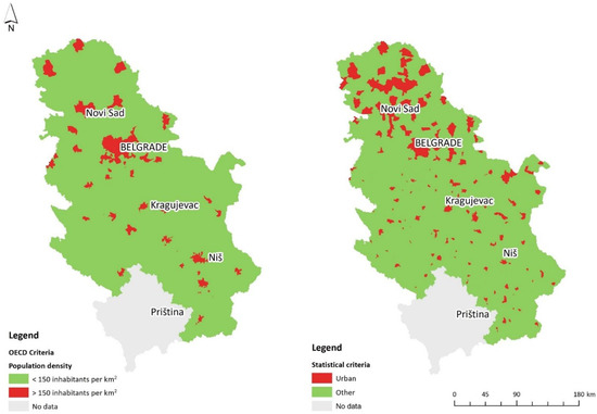
Figure 1.
Urban and rural areas according to the OECD (left) and statistical classification at the settlement level (right).
Figure 1 (left) shows urban and rural areas according to the OECD and the statistical classification at the settlement level (right).
The need for an adequate definition of settlements is also highlighted in the Spatial Plan of the Republic of Serbia from 2010 [39]. Without dealing with the problems of settlement classification, this national strategy document singled out three types of rural areas in Serbia at the NUTS 3 level (Nomenclature of Territorial Units for Statistics level 3). The methodology of allocation of these areas is based on a combination of the OECD criteria of population density and the basic structural characteristics and development opportunities in the region. The fact remains that this methodology is not widely accepted in planning practices in Serbia.
The concept of sustainable development has its background in international conventions and directives and refers to development where spatial planning at the local level plays a vital role in attempting the balancing of ecologic, social, and economic sustainability [42,43]. It is important to have a better understanding of the sustainability of rural and urban areas. Classification of these areas with an adequate recognition of the nature and aspects of rural and urban areas would be of great importance for creating future policies aligned with sustainable development goals [44,45,46].
With the aim to overcome problems and limitations of the existing classification, there were several recent studies trying to determine the main factors of rural areas and classify the rural area of the entire Republic of Serbia. Bogdanov et al. [47] classified rural municipalities into 4 different types based on 41 variables and statistics (using principal component method (PCA) and cluster analysis (CA)). Martinović and Ratkaj [48] discovered (also based on PCA) the 4 main components that can affect rural area classification based on 15 different variables. Gajić et al. [49] identified four factors and five types of rural and urban municipalities based on 15 variables.
4. Study Area
The Republic of Serbia (Figure 2) covers an area of 88,361 km2, populated by 7,186,862 inhabitants, according to the last census. The average population density was around 92 inhabitants per km2. Administratively, the territory of the country consists of two autonomous provinces (AP) ((1) Kosovo and Metohija and (2) Vojvodina) and 174 local self-government units (LSGUs) consisting of the City of Belgrade with a special status, 145 municipalities, and 28 cities. Each territory of the municipality/city is composed of a group of settlements (populated places) that administratively belong to them (according to the NUTS, settlement level in Serbia is comparable to the LAU 2). The network of settlements on the territory of the Republic of Serbia consists of 6158 settlements. The last census from 2011 covered 4709 (the area of Kosovo and Metohija was not covered by the 2011 Census) settlements. According to the data of the 2011 census, out of the total number of enumerated settlements, 4542 (97%) are classified in the category “other” which refers to non-urban settlements. According to the statistical classification, 59.44% of the population lived in urban settlements in Serbia, while the rest of the total population lived in non-urban settlements (40.56%).
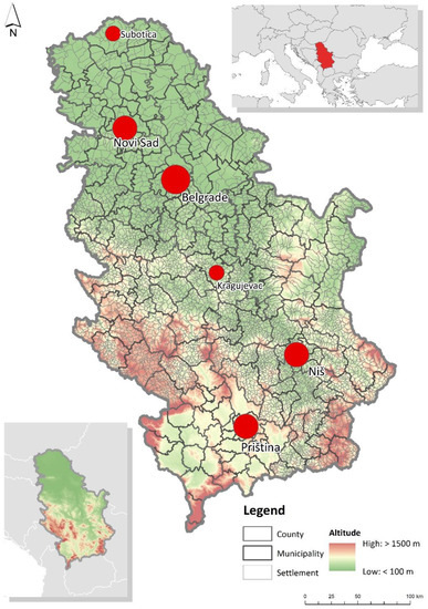
Figure 2.
Study area.
Although the share of the urban population is increasing, rural and peri-urban areas have the largest number of settlements. Moreover, 90.69% of settlements in Serbia have fewer than 2000 inhabitants and 25% of the population of Serbia lives in these settlements. On the other hand, only one settlement—the settlement of Belgrade—has more than a million inhabitants (1,166,763), which is 16.2% of the total population of the Republic of Serbia. The dominance of Belgrade in the settlement network of Serbia causes a strong spatial socio-economic polarization [50,51,52].
Vojvodina (plain, northern part of the country) has the largest share of medium and large settlements (5000–10,000 inhabitants) as the most important agricultural area of Serbia, while hamlets or very small villages (up to 100 inhabitants) are characteristic of hilly and mountainous areas of southern, southeastern, and southwestern Serbia, making up 20% of non-urban settlements in Serbia. The morphological characteristics of the terrain have conditioned different possibilities for the origin and development of the settlement. About 40% of the total number of settlements can be considered parts of mountainous areas.
5. Data and Materials
Different data sources were used for this research. Table 1 provides an overview, description, and data sources for each of the selected variables. Although the data of the Statistical Office of the Republic of Serbia [53] were mainly used for certain variables, publicly available geospatial data were also used. In addition to the official statistics, the European Settlement Map (ESM) database published in 2016 [54] was used to calculate the population density. The same source combined with the digital elevation model (DEM) [55] was used to derive average altitude where average altitude was calculated only for built-up parts of the settlement [56]. Land cover data were derived from CLC 2018 databases [57]. For calculating accessibility, data from the Open Street Map (OSM) 2018 [58] were derived and processed. For the indicator related to the availability of urban centers, travel time was measured as a distance (travel time by car) and then, by overlapping the settlements with the obtained service areas, a scale of weighted values from 1 to 4 was set, depending on the total settlement area and the area that is within the scope of a particular isochron. The research included 4604 settlements of the Republic of Serbia. The study did not cover settlements in the Autonomous Province of Kosovo and Metohija, due to the absence of data in the 2011 census. Furthermore, the research did not cover 11 settlements in which there were no inhabitants and 94 settlements for which the data were incomplete. Urban settlements were included because of their heterogeneity. Some settlements have urban settlement status but they do not meet urban standard criteria and, conversely, some settlements with urban character do not have urban settlement status.

Table 1.
Variables with description and data source.
6. Methods
The first step of the applied method involved the selection of relevant variables. The indicators are formed to reflect the main demographic, economic, and physical geographical characteristics of the rural area of Serbia. The choice of variables was directly influenced by the research of Gajić et al. [49] who implemented a similar methodology at the municipal level in Serbia. It is important to note that the choice of variables was limited by the lack of official data at the settlement level. Initially, 20 variables were included in the study, but after correlation analysis, 4 variables that indicated the same phenomena with a high level of correlation with other variables were removed. The final data set included 16 variables that best describe rural areas in Serbia (Table 1).
Primarily, 17 settlements with more than 50,000 inhabitants were removed, which according to all indicators have the characteristics of urban settlements. Other urban settlements were retained in the analysis with the aim of obtaining a more realistic view and heterogeneity of the urban–rural continuum. Therefore, further analysis included 4587 settlements.
The first step of the applied methodology (Figure 3) included the method of multivariate analysis. Multivariate analysis is widely used in spatial research as well as in rural research and delimitation [3,14,17,18,31,49,60,61,62,63,64,65,66,67,68,69,70,71,72]. In this study, factor analysis (FA) was used, which relies on the principal component method (PCA) to identify key factors that describe rural areas. The PCA is an exploratory statistical method for synthesizing information with the aim of reducing the number of variables. The goal of this method is to reduce the number of variables with minimal loss of information [69]. Basically, the PCA represents the extraction of factors of a reduced set of variables that explain most of the variance from the data set [70,73].
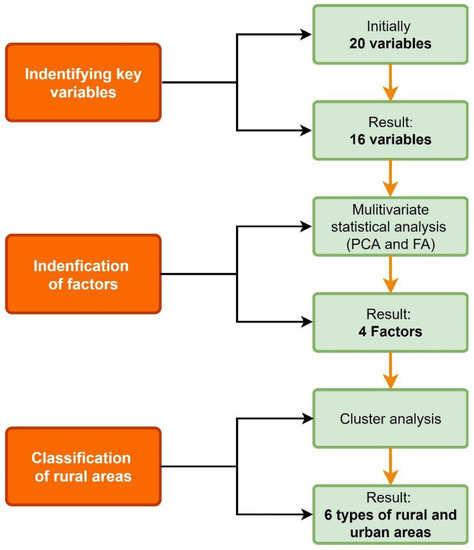
Figure 3.
Research methodology design. Principal component method = PCA, factor analysis = FA.
The dataset from Table 1 proved to be appropriate for PCA, according to the Kaiser–Meyer–Olkin (KMO) measure of sampling adequacy and the Bartlett test of sphericity. The significance of the Bartlett test (p < 0.001) and the high KMO value (0.874) justified the adequacy of the factor analysis in the next step.
Factor analysis was performed for 16 variables using PCA with Varimax rotation. Based on the obtained eigenvalues (greater than 1), four key factors were defined that describe rural areas in Serbia and explain 70.4% of the total model variance. With the aim of classifying settlements in Serbia with similar characteristics, cluster analysis (CA) was conducted as the final step of the applied methodology. The non-hierarchical k-means clustering method with a predefined number of clusters was applied in the study. A GIS was used to map clusters and detect spatial patterns of different types of rural areas.
7. Results
Table 2 represents the structure of the components in the rotated component matrix. For clear interpretation, all four factors were named based on the leading variables within the set.
Table 2.
Factor loadings (values in bold show the largest loading of each variable in one factor).
The first factor is the most important because it includes five variables and explains 41.2% of the total variance. This factor is characterized by high loadings from commuting and employment in the secondary and tertiary sector, which, together with loading scores connected to population with secondary education and income, can be described as a factor which is related to employment.
From the four variables included in the second factor, average household size and young population have high factor loadings, while the share of occupied dwellings and population change have a lower factor score. Therefore, the second factor, which describes 11.2% of the total variance, is characterized and named demographic capacity.
The third factor, named land-use intensity, describes 10.6% of the total variance. This factor includes the four variables related mostly to land cover and natural characteristics. Three of them have high factor loadings (agricultural land, forest area, and average altitude) and accessibility to the closest city center showed a lower value (0.474). Despite a lower score, accessibility to the closest city center is retained as it represents an important element of rurality. The existence of a strong negative correlation can be noted between the variables’ share of agricultural areas with other variables within this factor. In addition, variables named forest area and average altitude have a negative correlation with all other factors.
The last three variables, which describe 7.4% of the total variance, are included in the fourth factor, named population features. This factor consisted of the three main variables: total population and population with tertiary education with high factor scores and population density, which showed lower factor loading. Population density shows a negative correlation with the factor named land-use intensity. It is important to point out that the variable related to income also shows a high loading score in this factor, which is greater than population density.
The results of the cluster analysis are presented in Table 3. The values in the table show the relationship between factors and clusters. Based on the obtained results, six clusters were defined (Figure 4), where two describe urban areas.
Table 3.
Final cluster centers.
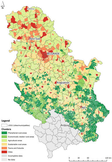
Figure 4.
Classification of rural areas in Serbia.
Cluster 1 includes 1081 settlements on the rural periphery, inhabited by only 2% of the total population of Serbia. Settlements belonging to this cluster cover around 23% of all settlements, which are characterized by extremely negative demographic tendencies. The negative correlation with all defined factors indicates that the opportunities for the development of these areas are greatly reduced. These areas include hilly-mountainous and border areas of southern, southwestern, and eastern Serbia, while they do not exist in the northern and central parts.
Cluster 2 includes 508 settlements and represents demographically and economically weaker rural areas. This cluster covers around 2% of the total population and around 11% of all settlements and it can be considered part of a cluster of rural periphery with slightly favorable values of individual variables. The factor related to demographic capacity is the only one with positive correlations with this cluster. These areas are mostly present in parts of southwestern Serbia and sporadically in parts of southeastern and eastern Serbia.
Cluster 3 (agricultural areas), with 1547 settlements, covers almost a third of the settlements in Serbia and 16% of the total population. The third factor and variables related to land use had the greatest influence on the formation of this cluster. The negative correlation with the first factor indicates that these settlements are predominantly agricultural settlements in which the highest income is generated in agricultural activities. The largest representation of these settlements is related to the traditional agricultural areas of AP Vojvodina and the Mačva region, while in Central Serbia they are related to lowland agricultural areas that are oriented towards local agricultural production. In eastern and southern Serbia, the position of these settlements is predisposed to natural characteristics and they are mostly located in river valleys. In southwestern and southeastern Serbia, these areas are not present due to natural constraints.
Cluster 4 is part of the rural area of Serbia and includes 1240 settlements, that is, 27% of all settlements and 15% of the total population of Serbia. These settlements are exposed to negative demographic trends, but the possibility of their revitalization is still possible, which shows a positive correlation with factors related to employment and demographic capacity. From the aspect of their revitalization, they can be considered sustainable. The spatial layout reveals that these areas are primarily adjacent to urban centers, as well as areas along major roads with developed daily migration and greater economic diversification of activities. These settlements follow the flows of urbanization and their development and dynamics are directly related to urban centers in terms of their production and socio-economic context.
The next cluster 5 on the rural–urban scale consists of 173 settlements that have a high level of urbanization. This cluster covers around 15% of the entire population and around 4% of all settlements. This group of settlements has a high degree of urbanization which is lower compared to the next described group of settlements which are part of cluster 6. This cluster consists of small- and medium-sized cities in all parts of Serbia, as well as typical suburbs around the largest urban centers—Belgrade and Novi Sad. Similar to the urban cluster, the variables such as total population and the share of the highly educated population had the greatest influence on the formation of these clusters as well as the variable of population density but with a smaller share.
Cluster 6 includes 38 settlements that, according to selected indicators, represent urban areas (cities), and they should be observed together with 17 settlements that were excluded at the beginning of the analysis, even though their total population is fewer than 50,000 inhabitants. This cluster includes half of the population of Serbia and covers less than 2% of all settlements. The fourth factor, called population features, had the greatest influence on the formation of this cluster, while the influence of other factors was negligible. These settlements are present in all areas in Serbia and have the most favorable average values of all indicators.
8. Discussion
This study gives analyses of spatial structure and patterns of rural areas in Serbia. Based on the obtained results, a spatial classification of rural and urban areas in Serbia has been proposed. The study included urban areas as well, although the primary focus of the study was on the rural areas. Such an approach has enabled a real perception of the rural–urban relations in space.
Through multivariate and GIS analysis, six types of areas were identified and analyzed according to their spatial distribution. This analysis was conducted at the lowest local level (level of settlement) which resulted in the differentiation of six types of rural and urban areas.
In general, the obtained results correspond well with similar studies conducted in Serbia [47,48,49], confirming that rural areas are very diverse regarding their demographic, economic, natural, and functional characteristics. However, those studies are presented on a broad spatial scale (cities and municipalities) and they included different variables; therefore, they are not completely comparable.
Compared to previous research by Gajić et al. [49], some findings in this study deviate significantly at the low-level scale; for example, variables that reflect land-use intensity have less significance. However, variables related to employment still remain the most important. The research could be improved with additional variables related to environment or life quality, which are not considered due to a lack of data on the settlement level.
It is important to emphasize that due to different aspects of rurality and spatial characteristics, rural heterogeneity must be observed for each country individually. Some of the variables can be applied in countries with similar natural and socio-economic conditions as in Serbia, but others may not be relevant as they do not properly reflect the rural concept of those countries, which then implies the inclusion of other variables.
In the context of a spatial planning framework and its implications, which is a secondary objective of this study, this research provides a fine-grained scale of rural and urban areas. This detailed classification based on a high number of variables allows for distinguishing settlement types and making decisions within municipality borders. Based on the obtained results, it is possible to determine the main features of rural areas and propose planning measures. Additionally, the choice of the indicators allows planners to capture the main urbanization flows at the local and regional level [3].
The most significant contribution of this study is that it covered all of Serbia, including almost all urban and rural settlements (for which data exist on a settlement level) that had not previously been processed in this type of research.
9. Conclusions
As it has been pointed out, rural areas are very diverse with no universal definition. The presented methodology aims to contribute to the design of a classification framework for rural areas that share similar characteristics as a useful tool for decision-making processes. The applied approach captured the multidimensionality of rural areas with high levels of detail. The typology can serve as a basis for creating concrete studies of rural development in the context of sustainable development. Spatial differentiation of rural and urban areas also enables the formation of individual instruments for monitoring or stimulating the development of the specific area in accordance with their specific needs. Recognizing different types of rural and urban areas at the local level represents an important step in spatial planning towards sustainable development. The proposed methodology can represent an important advantage over traditional classifications and could be beneficial for spatial planners and policy makers.
Author Contributions
Conceptualization, A.G. and N.K.; methodology, A.G.; formal analysis, A.G.; investigation, A.G. and B.P.; writing—original draft preparation, A.G., N.K., and B.P.; writing—review and editing, A.G. and B.P.; visualization, A.G., N.K., and B.P. All authors have read and agreed to the published version of the manuscript.
Funding
This research received no external funding.
Institutional Review Board Statement
Not applicable.
Informed Consent Statement
Not applicable.
Data Availability Statement
Not applicable.
Conflicts of Interest
The authors declare no conflict of interest.
References
- Antrop, M. Changing patterns in the urbanized countryside of Western Europe. Landsc. Ecol. 2000, 15, 257–270. [Google Scholar] [CrossRef]
- Beyazli, D.; Aydemir, S.; Öksüz, A.M.; Özlü, S. Rural typology with and inductive approach. Int. J. Environ. Res. Vol. 2017, 11, 225–241. [Google Scholar] [CrossRef]
- Madsen, M.F.; Kristensen, S.P.; Fertner, C.; Busck, A.G.; Jørgensen, G. Urbanisation of rural areas: A case study from Jutland, Denmark. Geogr. Tidsskr. Dan. J. Geogr. 2010, 110, 47–63. [Google Scholar] [CrossRef]
- Olsson, E.G.A.; Kerselaers, E.; Søderkvist Kristensen, L.; Primdahl, J.; Rogge, E.; Wästfelt, A. Peri-Urban Food Production and Its Relation to Urban Resilience. Sustainability 2016, 8, 1340. [Google Scholar] [CrossRef]
- Butsch, C.; Heinkel, S.-B. Periurban Transformations in the Global South and Their Impact on Water-Based Livelihoods. Water 2020, 12, 458. [Google Scholar] [CrossRef]
- Blunden, J.R.; Pryce, W.T.R.; Dreyer, P. The Classification of Rural Areas in the European Context: An Exploration of a Typology Using Neural Network Applications. Reg. Stud. 1998, 32, 149–160. [Google Scholar] [CrossRef]
- Halfacree, K. Locality and social representation: Space, discourse and alternative definitions of the rural. J. Rural Stud. 1993, 9, 23–37. [Google Scholar] [CrossRef]
- Pratt, A.C. Discourses of rurality: Loose talk or social struggle? J. Rural Stud. 1996, 12, 69–78. [Google Scholar] [CrossRef]
- Hoggart, K. Not a definition of rural. Area 1988, 20, 35–40. [Google Scholar]
- Hoggart, K. Let‘s Do Away with Rural. J. Rural Stud. 1990, 6, 245–257. [Google Scholar] [CrossRef]
- Sancho Comíns, J.; Reinoso Moreno, D. La delimitación del ámbito rural: Una cuestión clave en los programas de desarrollo rural. Estud. Geogr. C3A1ficos 2012, 73, 599–624. [Google Scholar] [CrossRef]
- Sorokin, P.A.; Zimmerman, C.C. Principles of Rural–Urban Sociology; Holt: New York, NY, USA, 1929. [Google Scholar]
- Hedlund, M. Mapping the Socioeconomic Landscape of Rural Sweden: Towards a Typology of Rural Areas. Reg. Stud. 2014, 460–474. [Google Scholar] [CrossRef]
- Cloke, J.P. An index of rurality for England and Wales. Reg. Stud. 1977, 11, 31–46. [Google Scholar] [CrossRef]
- Woods, M.; Heley, J. Conceptualisation of Rural-Urban Relations and Synergies. ROBUST Project Report, Deliverable 1.1. 2017. Available online: https://rural-urban.eu/publications/conceptualisation-rural-urban-relations-and-synergies (accessed on 26 November 2020).
- Murdoch, J.; Pratt, A.C. Rural studies: Modernism, postmodernism and the ‘post-rural’. J. Rural Stud. 1993, 9, 411–427. [Google Scholar] [CrossRef]
- Cloke, J.P.; Edwards, G. Rurality in England and Wales 1981: A replication of the 1971 index. Reg. Stud. 1986, 20, 289–306. [Google Scholar] [CrossRef]
- Harrington, V.; O’Donoghue, D. Rurality in England and Wales 1991: A Replication and Extension of the 1981 Rurality Index. Sociol. Rural. 1998, 38, 178–203. [Google Scholar] [CrossRef]
- Ocana-Riola, R.; Sanchez-Cantalejo, C. Rurality index for small areas in Spain. Soc. Indic. Res. 2005, 73, 247–266. [Google Scholar] [CrossRef]
- Prieto-Lara, E.; Ocana-Riola, R. Updating rurality index for small areas in Spain. Soc. Indic. Res. 2010, 95, 267–280. [Google Scholar] [CrossRef]
- Perlín, R.; Kucerova, S.; Kucera, Z. A typology of rural space in Czechia according to its potential for development. Geografie 2010, 115, 161–187. [Google Scholar] [CrossRef]
- Nestorová Dická, J.; Gessert, A.; Sninčák, I. Rural and non-rural municipalities in the Slovak Republic. J. Maps 2019, 15, 84–93. [Google Scholar] [CrossRef]
- OECD. Creating Rural Indicators for Shaping Territorial Policy; OECD Publishing: Paris, France, 1994. [Google Scholar]
- Pizzoli, E.; Gong, X. How to Best Classify Rural and Urban? In Rural-Urban Delimitation, A Statistical Analysis; Lenders, S., Lauwers, L., Kerselaers, E., Eds.; ILVA: Merelbeke, Belgium, 2007; pp. 1–13. Available online: http://www.stats.gov.cn/english/ICAS/papers/P020071017557234385229.pdf (accessed on 22 February 2018).
- Hurbánek, P. Recent developments in definitions of rurality/urbanity focus on spatial aspect and land cover composition and configuration. Eur. Xxi 2008, 17, 9–27. Available online: https://rcin.org.pl/Content/137/Europa_XXI_2008_17-internet.pdf?handler=pdf_browser#page=9 (accessed on 8 March 2018).
- Lukić, A. Mozaik Izvan Grada: Tipologija Ruralnih I Urbanizovanih Naselja Hrvatske; Meridijani: Samobor, Hrvatska, 2012. [Google Scholar]
- Gajić, A. Različiti metodološki pristupi u definisanju ruralnih i urbanih područja. Arhit. I Urban. 2015, 41, 63–67. [Google Scholar] [CrossRef]
- EUROSTAT. Methodological Manual on Territorial Typologies—2018 Edition; Publications Office of the European Union: Luxembourg, 2019; Available online: https://ec.europa.eu/eurostat/documents/3859598/9507230/KS-GQ-18-008-EN-N.pdf/a275fd66-b56b-4ace-8666-f39754ede66b?t=1573550953000 (accessed on 8 December 2020). [CrossRef]
- EUROSTAT. Eurostat Regional Yearbook—2020 Edition; Publications Office of the European Union: Luxembourg, 2020; Available online: https://ec.europa.eu/eurostat/documents/3217494/11348978/KS-HA-20-001-EN-N.pdf/f1ac43ea-cb38-3ffb-ce1f-f0255876b670?t=1601901088000 (accessed on 10 December 2020). [CrossRef]
- Dijkstra, L.; Poelman, H. A Harmonised Definition of Cities and Rural Areas: The New Degree of Urbanization; European Commission Urban and Regional Policy: Brussels, Belgium, 2014; Available online: https://ec.europa.eu/regional_policy/sources/docgener/work/2014_01_new_urban.pdf (accessed on 10 March 2018).
- Ballas, D.; Kalogerisis, T.; Labrianidis, L. A comparative study of typologies for rural areas in Europe. In 43rd European Congress of the Regional Science Association; European Regional Science Association: Jyväskylä, Finland, 2003; Available online: https://www.jyu.fi/ersa2003/cdrom/papers/515.pdf (accessed on 19 February 2018).
- Gallego, J. Mapping Rural/Urban Areas from Population Density Grid; JRC—Institute for Environment and Sustainability: Ispra, Italy, 2008; pp. 1–19. Available online: http://81.47.175.201/urban_rural/documents/docs_others/Gallego_urban_rural.pdf (accessed on 7 March 2018).
- Bengs, C.; Schmidt-Thomé, K. Urban-Rural Relations in Europe. ESPON 1.1.2—Final Report; Helsinki University of Technology—Centre for Urban and Regional Studies: Helsinki, Finland, 2006; Available online: https://www.espon.eu/sites/default/files/attachments/fr-1.1.2_revised-full_31-03-05.pdf (accessed on 13 March 2018).
- Pászto, V.; Brychtová, A.; Tuček, P.; Marek, L.; Burian, J. Using a fuzzy inference system to delimit rural and urban LSGU in the Czech Republic in 2010. J. Maps 2015, 11, 231–239. [Google Scholar] [CrossRef]
- Krunić, N.; Bajat, B.; Kilibarda, M. Dasymetric Mapping of Population Distribution in Serbia Based on Soil Sealing Degrees Layer. In Surface Models for Geosciences. Lecture Notes in Geoinformation and Cartography; Růžičková, K., Inspektor, T., Eds.; Springer: Cham, Germany, 2015; pp. 137–149. [Google Scholar] [CrossRef]
- Halfacree, K. Urban-rural continuum. In International Encyclopedia of Human Geography; Kitchin, R., Thrift, N., Eds.; Elsevier: Oxford, UK, 2009; Volume 1, pp. 119–124. [Google Scholar]
- Firoz, C.M.; Banerji, H.; Sen, J. A Methodology to Define the Typology of Rural Urban Continuum Settlements in Kerala. J. Reg. Dev. Plan. 2014, 3, 49–60. [Google Scholar]
- Pagliacci, F. Measuring EU Urban-Rural Continuum Through Fuzzy Logic. Tijdschr. Voor Econ. En Soc. Geogr. 2016, 108, 157–174. [Google Scholar] [CrossRef]
- Zakon o Prostornom planu Republike Srbije 2010–2020 (PPRS). Available online: https://www.mgsi.gov.rs/sites/default/files/ZAKON%20O%20PROSTORNOM%20PLANU%20RS%20OD%202010%20DO%202020.pdf (accessed on 18 January 2012).
- Stevanović, R. Urban Settlements in the Republic of Serbia in Population Censuses from 1948 to 2002. Stanovništvo 2004, 42, 109–126. [Google Scholar] [CrossRef]
- Bogdanov, N. Small Rural Households in Serbia and Rural Non-Farm Economy; UNDP Serbia: Belgrade, Serbia, 2007; Available online: https://www.rs.undp:content/serbia/en/home/library/poverty/small-rural-households-in-serbia-and-rural-non-farm-economy.html (accessed on 14 February 2018).
- WCED. Our Common Future; Oxford University Press: Oxford, UK, 1987. [Google Scholar]
- UN. Agenda 21: Programme for Action for Sustainable Development, Rio Declaration on Environment and Development, Statement of Forest Principles. In Proceedings of the Final Texts of Agreements Negotiated by Governments at the United Nations Conference on Environment and Development (UNCED), Rio de Janeiro, Brazil, 3–14 June 1992. [Google Scholar]
- Pitot, M.; Yigitcanlar, T.; Sipe, N.; Evans, R. Land Use & Public Transport Accessibility Index (LUPTAI) tool: The Development and Pilot Application of LUPTAI for the Gold Coast. In Proceedings of the 29th Australian Transport Research Forum, Gold Coast, Australia, 27–29 September 2006; pp. 1–18. [Google Scholar]
- Yigitcanlar, T.; Kamruzzaman, M.; Teriman, S. Neighborhood sustainability assessment: Evaluating residential development sustainability in a developing country context. Sustainability 2015, 7, 2570–2602. [Google Scholar] [CrossRef]
- Sheikhnejad, Y.; Yigitcanlar, T. Scientific Landscape of Sustainable Urban and Rural Areas Research: A Systematic Scientometric Analysis. Sustainability 2020, 12, 1293. [Google Scholar] [CrossRef]
- Bogdanov, N.; Meredith, D.; Efstratoglou, S.A. Tipology of Rural Areas in Serbia. Econ. Ann. 2008, 177, 7–29. [Google Scholar] [CrossRef]
- Martinović, M.; Ratkaj, I. Sustainable rural development in Serbia: Towards a quantitative typology of rural areas. Carpathian J. Earth Environ. Sci. 2015, 10, 37–48. [Google Scholar]
- Gajić, A.; Krunić, N.; Protić, B. Towards a new methodological framework for the delimitation of rural and urban areas: A case study of Serbia. Geogr. Tidsskr. Dan. J. Geogr. 2018, 118, 160–172. [Google Scholar] [CrossRef]
- Tošić, D.; Krunić, N. Urbane aglomeracije u funkciji regionalne integracije Srbije i Jugoistočne Evrope. Glas. Srp. Geogr. Društva 2005, 85, 137–147. [Google Scholar]
- Živanović, Z.; Tošić, B.; Nikolić, T.; Gatarić, D. Urban System in Serbia—The Factor in the Planning of Balanced Regional Development. Sustainability 2019, 11, 4168. [Google Scholar] [CrossRef]
- Đukičin-Vučković, S.; Milanković-Jovanov, J.; Ivanović-Bibić, L.; Đorđević, J.; Đorđević, T.; Stamenković, I. Changes in the Hierarchy of Settlements and Attitude of the Local Population: Evidence from a Developing Region. J. Geogr. Inst. Jovan Cvijic Sasa 2020, 70, 227–240. [Google Scholar] [CrossRef]
- Statistical Office of the Republic of Serbia (SORS). Census 2011. Available online: https://www.stat.gov.rs/en-us/oblasti/popis/popis-2011/ (accessed on 6 February 2018).
- Copernicus Programme—Copernicus Land Monitoring Service. ESM 2012—Release 2016. Available online: https://land.copernicus.eu/pan-european/GHSL/european-settlement-map/EU%20GHSL%202014 (accessed on 9 February 2019).
- Copernicus Programme—Copernicus Land Monitoring Service. EU-DEM v1.1. Available online: https://land.copernicus.eu/imagery-in-situ/eu-dem/eu-dem-v1.1 (accessed on 9 February 2018).
- Krunić, N.; Gajić, A.; Srnić, D.; Tošić, D. Spatial Aspects of Demographic Processes in Serbia. Stanovništvo 2018, 56, 23–38. [Google Scholar] [CrossRef]
- Copernicus Programme—Copernicus Land Monitoring Service. Corine Land Cover 2018. Available online: https://land.copernicus.eu/pan-european/corine-land-cover/clc2018?tab=download (accessed on 19 October 2019).
- Geofabrik. OpenStreetMap Data. Available online: https://download.geofabrik.de/ (accessed on 9 February 2018).
- Statistical Office of the Republic of Serbia (SORS). 2011 Census of Population, Households and Dwellings in the Republic of Serbia—Documentation Table. Available online: https://www.stat.gov.rs/en-us/oblasti/popis/ (accessed on 26 January 2021).
- Copus, A.K.; Crabtree, J.R. Indicators of socio-economic sustainability: An application to remote rural Scotland. J. Rural Stud. 1996, 12, 41–54. [Google Scholar] [CrossRef]
- Ilbery, B. Dorset agriculture. Classif. Reg. Types. Trans. Inst. Br. Geogr. 1981, 6, 214–227. [Google Scholar] [CrossRef]
- Klufová, R. Current Delimitation and Typology of the Czech Countryside and its Importance for Rural Development. East. Eur. Countrys. 2016, 22, 229–251. [Google Scholar] [CrossRef]
- Kostrowicki, J. Types of agriculture in Britain in the light of types of agriculture map of Europe. Geogr. Pol. 1989, 56, 133–154. Available online: http://rcin.org.pl/Content/4201/WA51_13397_r1989-t56_Geogr-Polonica.pdf#page=135 (accessed on 19 February 2018).
- Openshaw, S. Multivariate analysis of census data: The classification of areas. In A Census Users’ Handbook; Rhind, D., Ed.; Methuen: London, UK, 1983; pp. 243–264. [Google Scholar]
- Öğdül, H. Urban and Rural Definitions in Regional Context: A Case Study on Turkey. Eur. Plan. Stud. 2010, 18, 1519–1541. [Google Scholar] [CrossRef]
- Cárdenas Alonso, G.; Nieto Masot, A. Towards Rural Sustainable Development? Contributions of the EAFRD 2007–2013 in Low Demographic Density Territories: The Case of Extremadura (SW Spain). Sustainability 2017, 9, 1173. [Google Scholar] [CrossRef]
- Zambon, I.; Benedetti, A.; Ferrara, C.; Salvati, L. Soil Matters? A Multivariate Analysis of Socioeconomic Constraints to Urban Expansion in Mediterranean Europe. Ecol. Econ. 2018, 146, 173–183. [Google Scholar] [CrossRef]
- Lin, J.; Lei, J.; Yang, Z.; Li, J. Differentiation of Rural Development Driven by Natural Environment and Urbanization: A Case Study of Kashgar Region, Northwest China. Sustainability 2019, 11, 6859. [Google Scholar] [CrossRef]
- Cuesta Molestina, R.; Villagómez Orozco, M.; Sili, M.; Meiller, A. A methodology for creating typologies of rural territories in Ecuador. Soc. Sci. Humanit. Open 2020, 2, 100032. [Google Scholar] [CrossRef]
- Nieto Masot, A.; Cárdenas Alonso, G.; Engelmo Moriche, Á. Design of a Development Index for Spanish Municipalities. Sustainability 2020, 12, 8910. [Google Scholar] [CrossRef]
- Laurin, F.; Pronovost, S.; Carrier, M. The end of the urban-rural dichotomy? Towards a new regional typology for SME performance. J. Rural Stud. 2020, 80, 53–75. [Google Scholar] [CrossRef]
- Hornowski, A.; Parzonko, A.; Kotyza, P.; Kondraszuk, T.; Bórawski, P.; Smutka, L. Factors Determining the Development of Small Farms in Central and Eastern Poland. Sustainability 2020, 12, 5095. [Google Scholar] [CrossRef]
- Cuadras, C.M. Nuevos Métodos De Análisis Multivariante; CM Ceditions: Barcelona, Spain, 2007; Available online: https://www.academia.edu/8119269/NUEVOS_M%C3%89TODOS_DE_AN%C3%81LISIS_MULTIVARIANTE (accessed on 19 December 2020).
Publisher’s Note: MDPI stays neutral with regard to jurisdictional claims in published maps and institutional affiliations. |
© 2021 by the authors. Licensee MDPI, Basel, Switzerland. This article is an open access article distributed under the terms and conditions of the Creative Commons Attribution (CC BY) license (http://creativecommons.org/licenses/by/4.0/).