
A Landscape Persistence Assessment of Częstochowa Upland: A Case Study of Ogrodzieniec, Poland


Abstract
1. Introduction
- (a)
- to determine landscape persistence by defining the continuity of a given type of landscape of Ogrodzieniec using the persistence index,
- (b)
- to determine the spatial range of the landscape persistence of Ogrodzieniec,
- (c)
- to define and introduce into the literature the concept of isochrones of landscape persistence,
- (d)
- to analyze the evolution of the cultural landscape of a selected settlement unit (Ogrodzieniec municipality) and its current structure against the backdrop of the landscape of the whole geographical region.
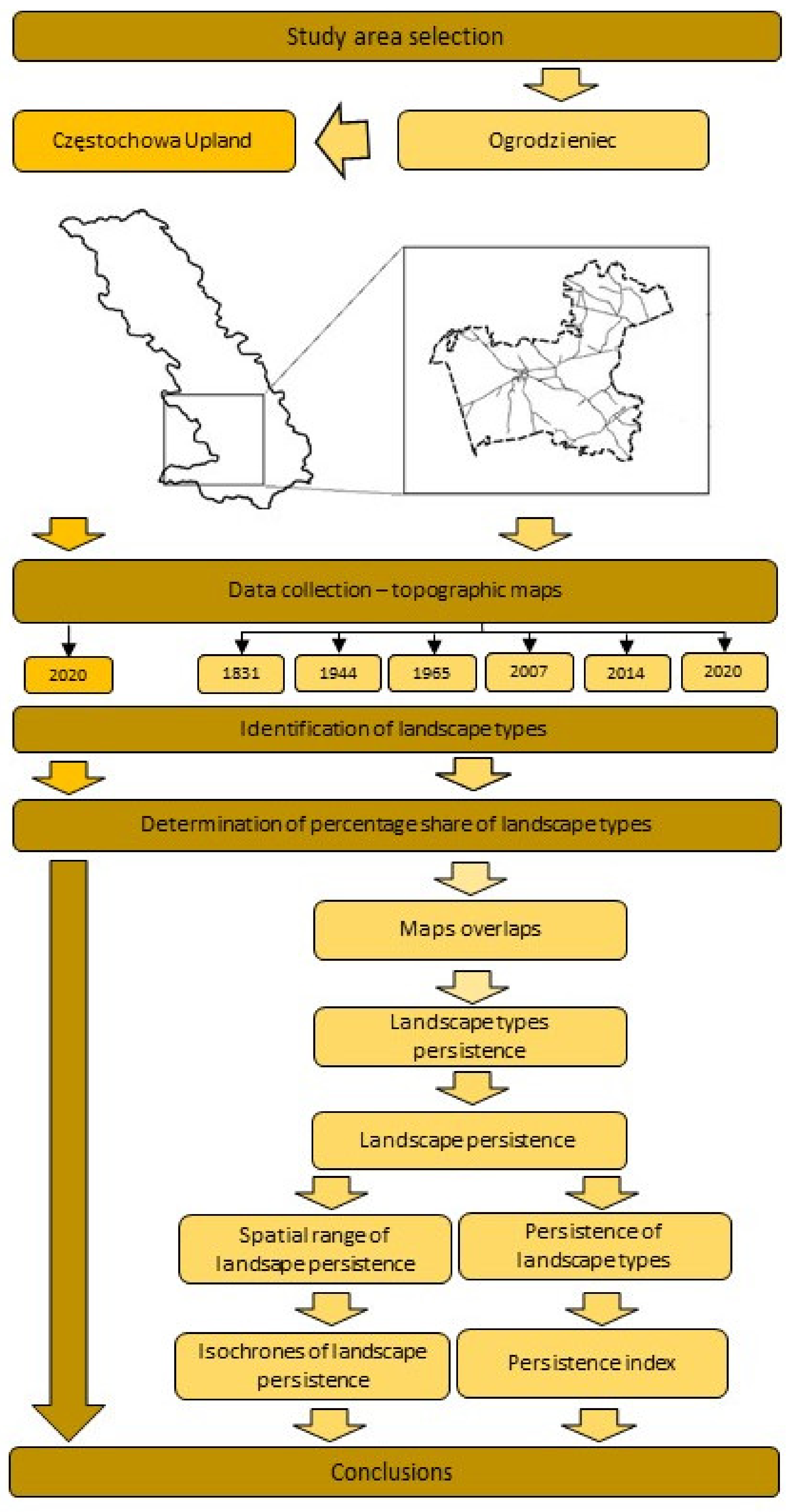
2. Materials and Methods
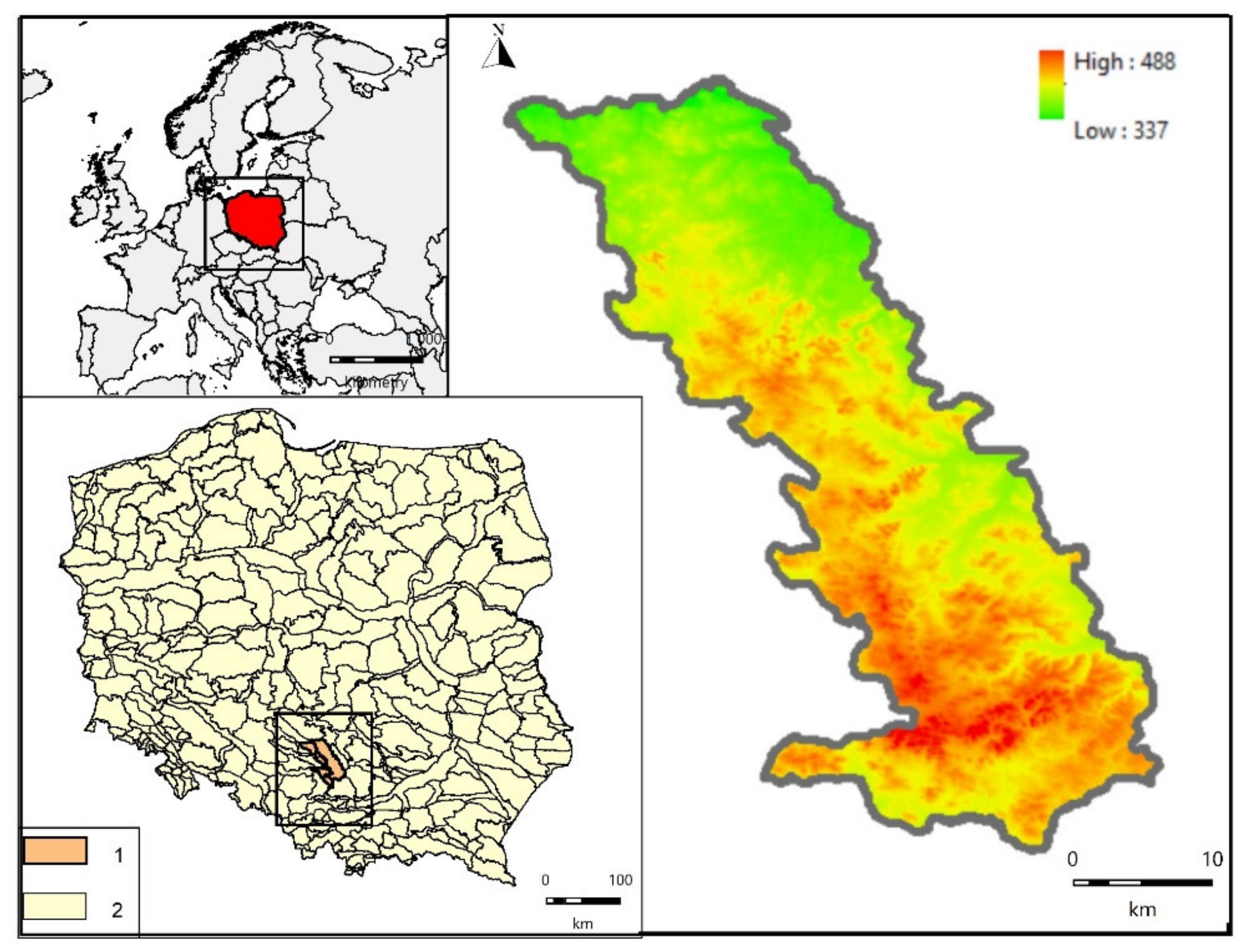
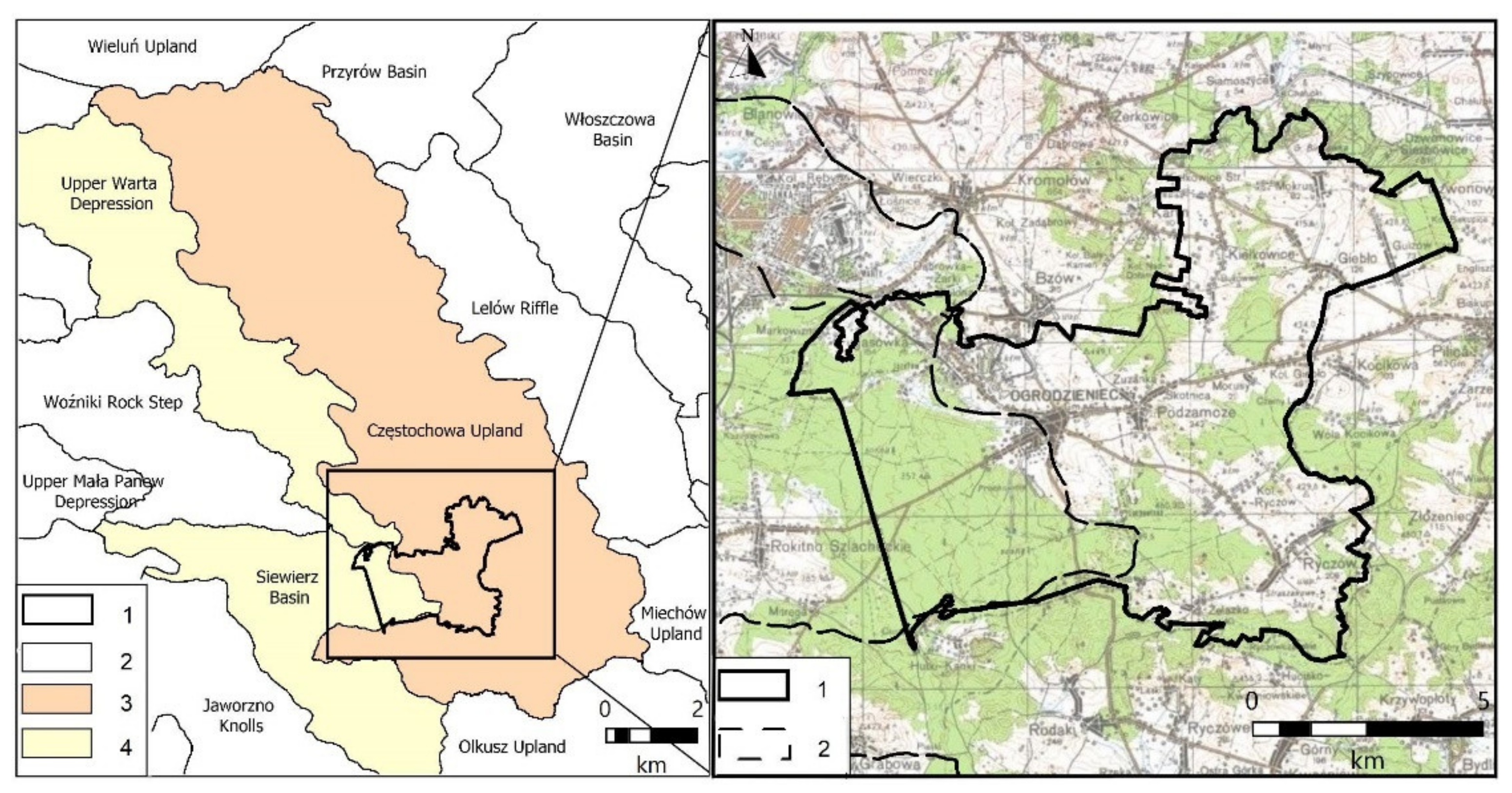
2.1. Study Area
2.2. Materials
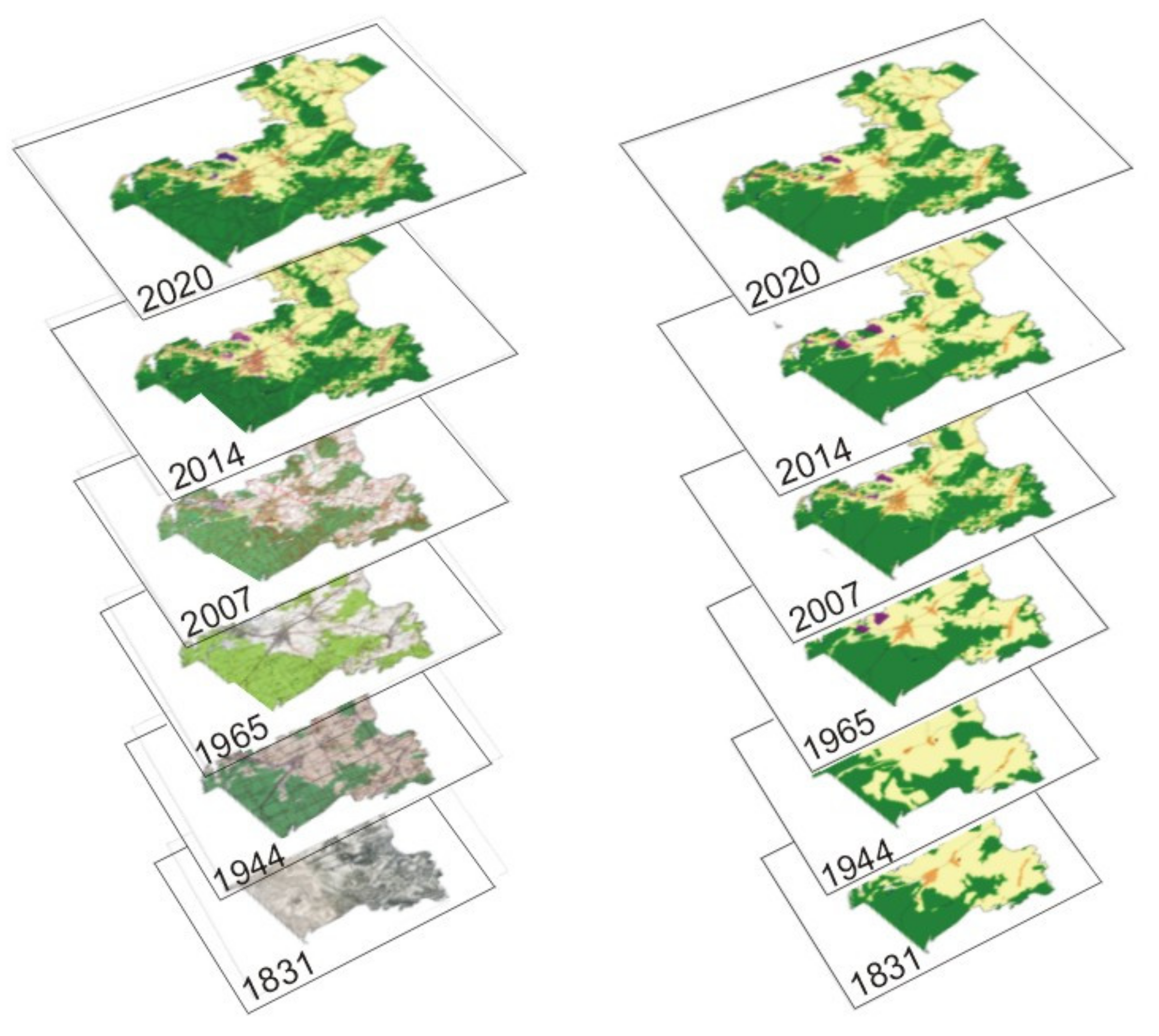
2.3. Methods
3. Results
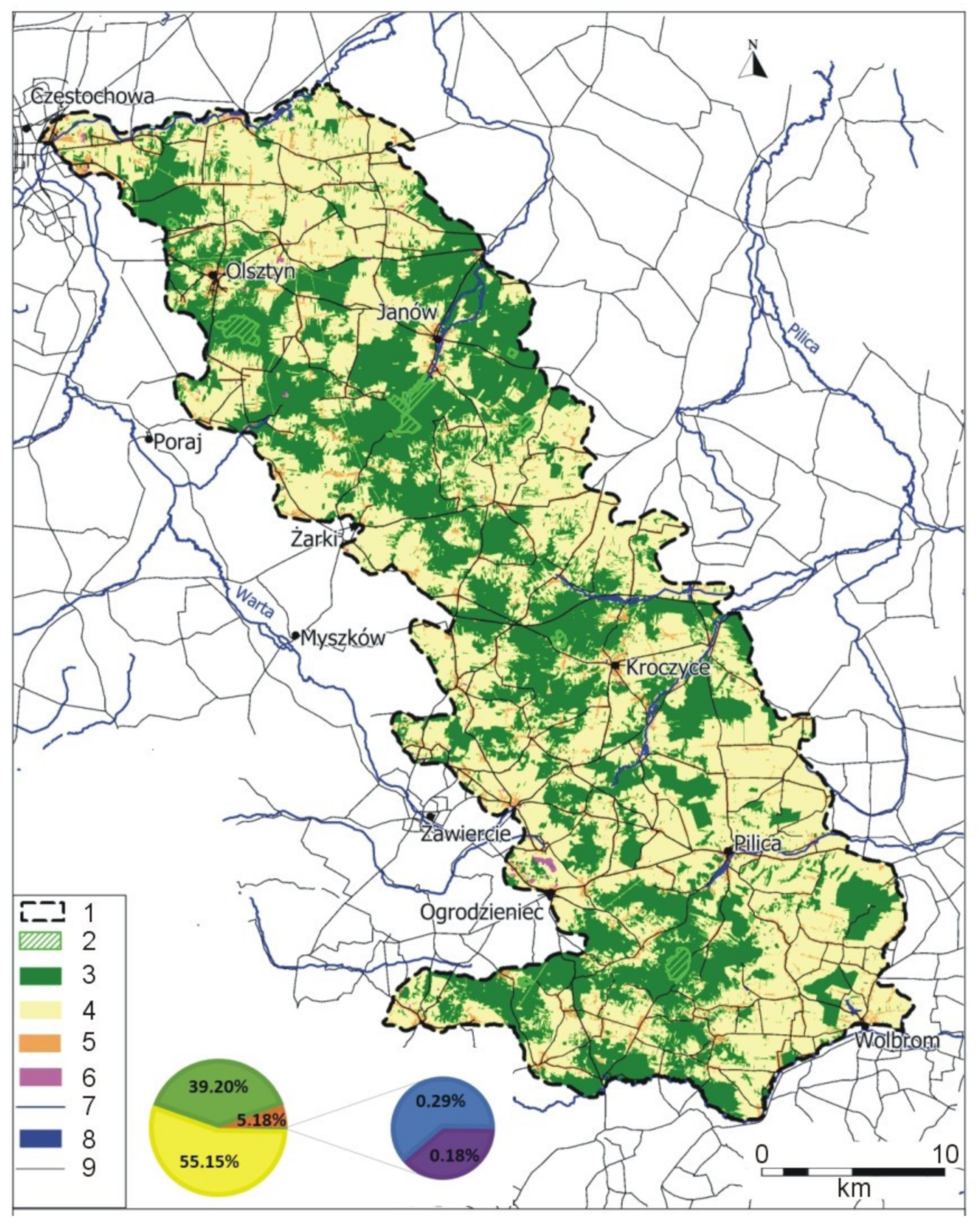
3.1. Current Landscape of the Częstochowa Upland
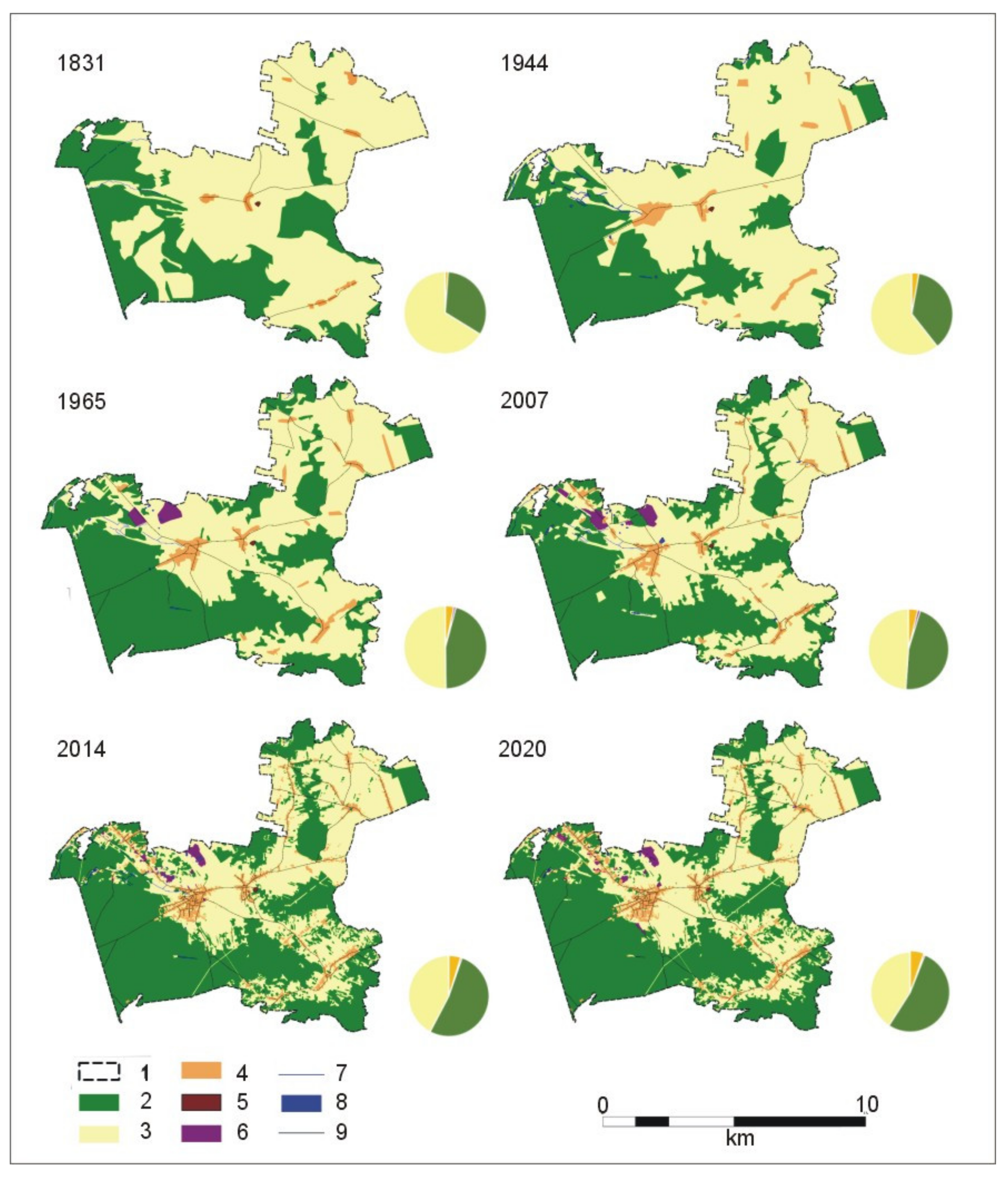
3.2. Landscape Persistence of the Ogrodzieniec Municipality
4. Discussion
4.1. Comparison of the Changing Landscape Structure of the Ogrodzieniec Municipality and the Częstochowa Upland
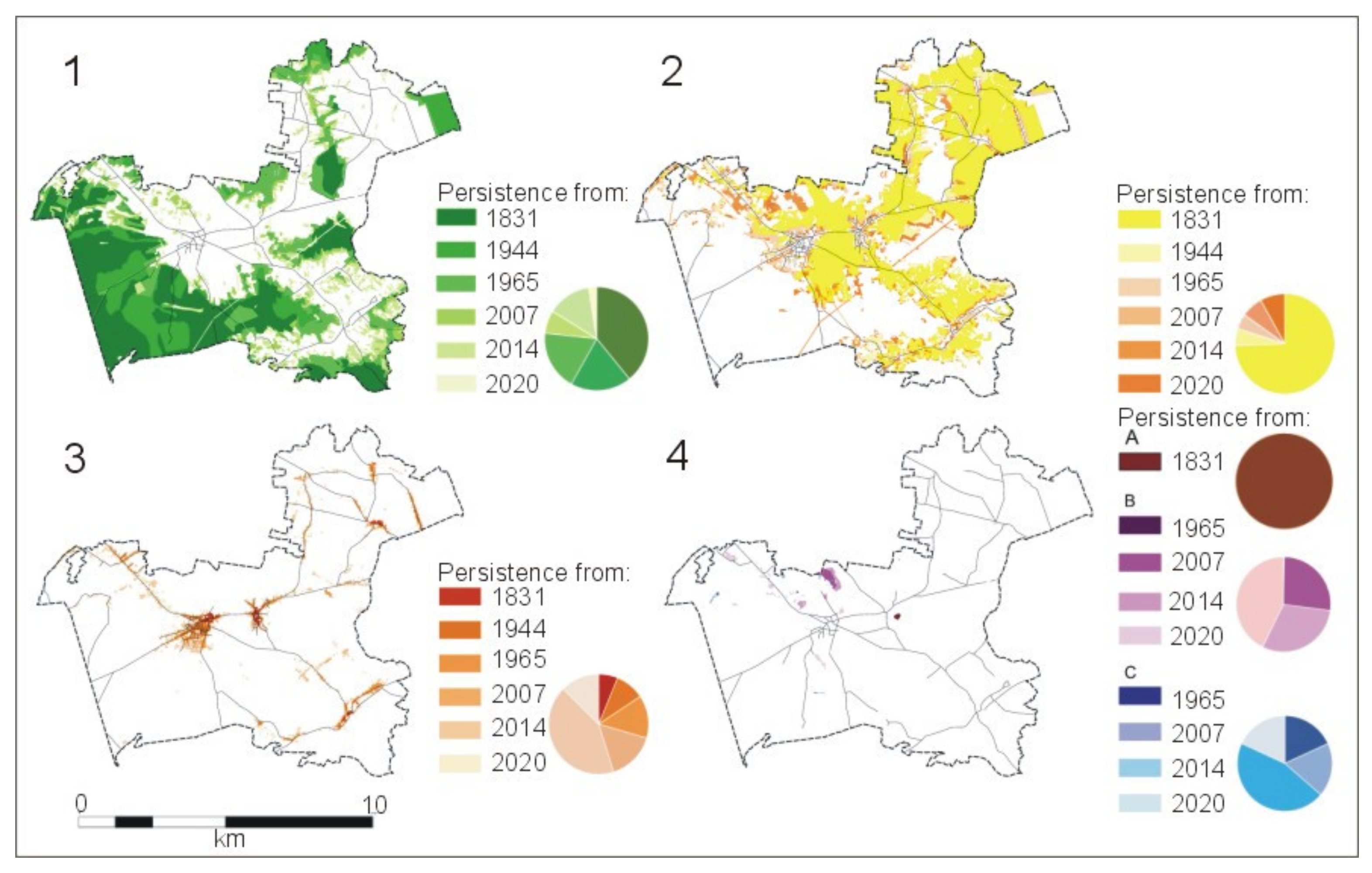
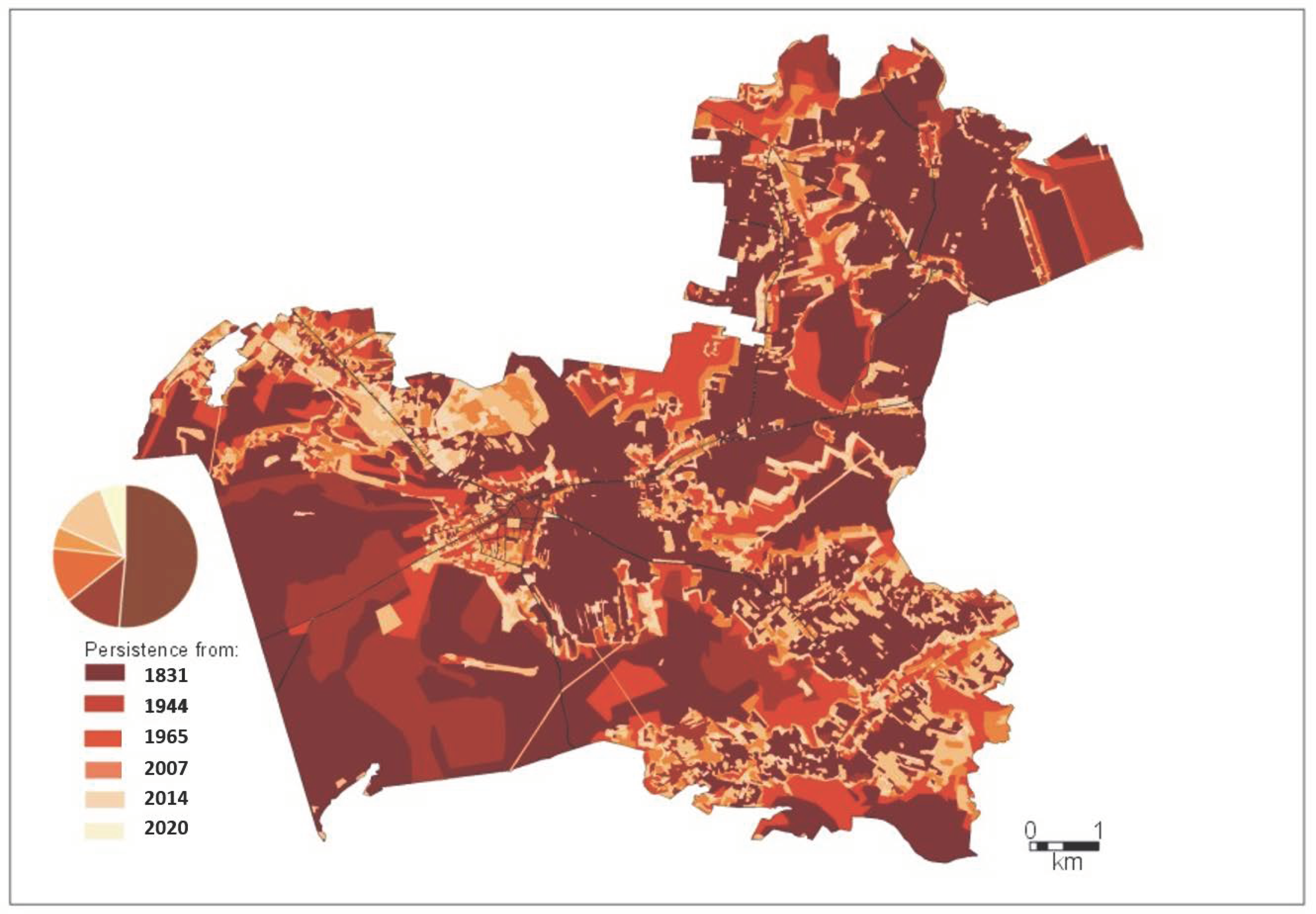
4.2. The Persistence of the Ogrodzieniec Landscape
5. Conclusions
- According to the persistence index, the most persistent landscape in Ogrodzieniec is the fortified landscape, which remained unchanged during the surveyed period. The next most persistent is the forest landscape. The least persistent is the industrial landscape.
- The current landscape analysis of the Ogrodzieniec municipality shows a prevalence of forest landscape, although in the 19th and 20th centuries and at the beginning of the 21st, the agricultural landscape was dominant.
- It can be observed that in the area of Ogrodzieniec over the surveyed period the percentage share of forest landscapes is higher, and the percentage share of agricultural landscapes is lower than in the entire Upland area.
- Due to ongoing urbanization and suburbanization, high growth of settlement landscapes was recorded in Ogrodzieniec. The share of settlement landscapes in Ogrodzieniec in relation to the Upland was variable: lower in the 19th and 20th centuries, and higher in the 21st century. This is caused, among other factors, by strong tourist pressure.
- Due to the abandonment of agriculture and afforestation policy, the increase in forest and decrease of agricultural landscape was remarkable at the beginning of the 21st century, both in the entire Upland area and the Ogrodzieniec municipality. After this period, the change in policy in favor of retaining agricultural cultivation has slowed down the growth of forested landscapes.
- Against the backdrop of the Częstochowa Upland, the landscape of Ogrodzieniec can be considered to be persistent. The largest area of the municipality is occupied by the most permanent landscapes, dating from before 1831.
- Overlapping the isochrones of individual landscape types allows the persistence isochrones of the entire landscape area to be delineated.
- The developed persistence isochrones allow the determination and spatial visualization of landscape persistence in the studied areas and thus makes it possible to identify landscapes of highest ecological and/or cultural value.
- The method of landscape persistence assessment proposed and tested in the area of Ogrodzieniec may be used to record changes in the landscape in short intervals of time to assess the rate of change. This is very important for predicting the dynamics of future landscapes, which has practical applications for sustainable spatial planning, especially in areas of strong anthropopressure.
Author Contributions
Funding
Institutional Review Board Statement
Informed Consent Statement
Data Availability Statement
Conflicts of Interest
References
- Ossing, F.; Negendank, J.F.W.; Emmermann, R. Wie entsteht Landschaft? Gemäldegalerie der Staatl. Museen zu Berlin (Hrsg.), Die Kleine Eiszeit. Holländische Landsch. 2001, 17, 26–40. [Google Scholar]
- Myga-Piątek, U. Krajobrazy Kulturowe. Aspekty Ewolucyjne I Typologiczne; Uniwersytet Śląski: Katowice, Poland, 2012; pp. 1–376. [Google Scholar]
- Plumwood, V. The Concept of a Cultural Landscape: Nature, Culture and Agency in The Land. Ethic. Environ. 2006, 11, 115–150. [Google Scholar] [CrossRef]
- Jones, M. The Concept of Cultural Landscape: Discourse and Narratives. In Landscape Interfaces; Springer Science and Business Media LLC: Dordrecht, The Netherlands, 2003; pp. 21–51. [Google Scholar]
- Taylor, K. Landscape and meaning: Context for a global discourse on cultural landscape values. In Managing Cultural Land-Scapes; Routledge, Taylor & Francis Group: London, UK, 2012. [Google Scholar]
- Myga-Piątek, U. Spór o pojęcie krajobrazu w geografii i dziedzinach pokrewnych. Przegląd Geograficzny 2001, 73, 163–176. [Google Scholar]
- Sobala, M. Pasture landscape durability in the Beskid Mountains (Western Carpathians, Poland). Geogr. Pol. 2018, 91, 197–216. [Google Scholar] [CrossRef]
- Burton, P.J. Striving for Sustainability and Resilience in the Face of Unprecedented Change: The Case of the Mountain Pine Beetle Outbreak in British Columbia. Sustainability 2010, 2, 2403–2423. [Google Scholar] [CrossRef]
- Pelorosso, R.; Della Chiesa, S.; Tappeiner, U.; Leone, A.; Rocchini, D. Stability analysis for defining management strategies in abandoned mountain landscapes of the Mediterranean basin. Landsc. Urban. Plan. 2011, 103, 335–346. [Google Scholar] [CrossRef]
- Peng, B.F.; Chen, D.L.; Li, W.J.; Wang, Y.L. Stability of landscape pattern of land use: A case study of Changde. Sci. Geogr. Sin. 2013, 33, 1484–1488. [Google Scholar]
- Bonacini, E.; Groppi, M.; Monaco, R.; Soares, A.; Soresina, C. A network landscape model: Stability analysis and numerical tests. Commun. Nonlinear Sci. Numer. Simul. 2017, 48, 569–584. [Google Scholar] [CrossRef]
- Grimm, V.; Wissel, C. Babel, or the ecological stability discussions: An inventory and analysis of terminology and a guide for avoiding confusion. Oecologia 1997, 109, 323–334. [Google Scholar] [CrossRef] [PubMed]
- Affek, A. Dynamika krajobrazu. Uwarunkowania i prawidłowości na przykładzie dorzecza Wiaru w Karpatach (XVIII-XXI wiek). Landscape dynamics. Determinants and patterns on the example of the Wiar river basin in the Carpathians (18 th–21st century). Prace Geogr. 2016, 251, 247. [Google Scholar]
- Lieskovský, J.; Kenderessy, P.; Špulerová, J.; Lieskovský, T.; Koleda, P.; Kienast, F.; Gimmi, U. Factors affecting the persistence of traditional agricultural landscapes in Slovakia during the collectivization of agriculture. Landsc. Ecol. 2014, 29, 867–877. [Google Scholar] [CrossRef]
- Lieskovský, J.; Bürgi, M. Persistence in cultural landscapes: A pan-European analysis. Reg. Environ. Chang. 2017, 18, 175–187. [Google Scholar] [CrossRef]
- Schulp, C.J.; Levers, C.; Kuemmerle, T.; Tieskens, K.; Verburg, P. Mapping and modelling past and future land use change in Europe’s cultural landscapes. Land Use Policy 2019, 80, 332–344. [Google Scholar] [CrossRef]
- Godziek, J.; Szypuła, B. Durability of forest cover in the Ochotnica Valley (Gorce Mts.) and in the Solinka Valley (Bieszczady Mts.) in the 18th-21st centuries. Geogr. Pol. 2020, 93, 69–88. [Google Scholar] [CrossRef]
- Wolski, J. Trwałość krajobrazu wiejskiego na przykładzie przekształceń zbiorowisk roślinnych bieszczadzkiej „krainy dolin” w ciągu ostatnich 150 lat. Persistence of former rural landscape for example changes of “country of valleys” plant communities in Bieszczady Mountains during the last 150 years. Chrońmy Przyr. Ojcz. 2009, 65, 441–448. [Google Scholar]
- Pǎtru-Stupariu, I.; Tudor, C.A.; Stupariu, M.S.; Buttler, A.; Peringer, A. Landscape persistence and stakeholder perspectives: The case of Romania’s Carpathians. Appl. Geogr. 2016, 69, 87–98. [Google Scholar] [CrossRef]
- Solon, J.; Borzyszkowski, J.; Bidłasik, M.; Richling, A.; Badora, K.; Balon, J.; Brzezińska-Wójcik, T.; Chabudziński, Ł.; Dobrowolski, R.; Grzegorczyk, I.; et al. Physico-geographical mesoregions of Poland: Verification and adjustment of boundaries on the basis of contemporary spatial data. Geogr. Pol. 2018, 91, 143–170. [Google Scholar] [CrossRef]
- Czeppe, Z. Regiony fizycznogeograficzne Wyżyny Krakowsko-Wieluńskiej i zagadnienia jej ochrony. Studia. Ośrodka Dok Mentacji Fizjogr. 1971, 1, 20–31. [Google Scholar]
- Kondracki, J. Geografia Regionalna Polski; Wydawnictwo Naukowe PWN: Warszawa, Poland, 1998; pp. 1–440. [Google Scholar]
- Plit, J. Regionalizacja współczesnych krajobrazów Historyczno–kulturowych Polski. Prace Kom. Kraj. Kult. 2015, 27, 79–94. [Google Scholar]
- Skowronek-Schmidt, I. Zróżnicowanie I Przemiany Naturalnej I Półnaturalnej Roślinności Kuesty Górnojurajskiej Oraz Związanej Z Nią Flory. Ph.D. Thesis, Uniwersytet Śląski, Katowice, Poland, 2019. [Google Scholar]
- Cygankiewicz, I. Problem rozproszenia zabudowy w krajobrazie wiejskim, na przykładzie gminy Ogrodzieniec. Przestrz. Forma 2011, 15, 323–334. [Google Scholar]
- Majgier, L.; Badera, J.; Rahmonov, O. Kamieniołomy w województwie śląskim jako obiekty turystyczno-rekreacyjne na terenach uprzemysłowionych. Probl. Ekol. Kraj. 2010, 27, 267–275. [Google Scholar]
- Chmielewski, T.J. Systemy Krajobrazowe. Struktura, Funkcjonowanie, Planowanie; Wydawnictwo Naukowe PWN: Warszawa, Poland, 2012; pp. 1–408. [Google Scholar]
- Nita, J.; Myga-Piątek, U. Krajobrazowe skutki wzrostu powierzchni leśnych na Wyżynie Częstochowskiej. Prace Kom. Kraj. Kult. 2012, 16, 191–207. [Google Scholar]
- Kaliszewski, A. Krajowy Program Zwiększania Lesistości—Stan i trudności realizacji z perspektywy lokalnej. National Program for Expanding of Forest Cover—Implementation and its difficulties from a local view. Studia Mater. Cent. Edukac. Przyr. Leśnej 2016, 18, 7–19. [Google Scholar]
- Gaston, K.J.; Pressey, R.L.; Margules, C.R. Persistence and vulnerability: Retaining biodiversity in the landscape and in pro-tected areas. J. Biosci. 2002, 27, 361–384. [Google Scholar] [CrossRef]
- Ustawa z dnia 24 kwietnia 2015 r. o zmianie niektórych ustaw w związku ze wzmocnieniem narzędzi ochrony krajobrazu. Act of 24 April 2015 amending some acts in connection with the strengthening of landscape protection tools. J. Laws 2015, 774, 1688.
- Europejska Konwencja Krajobrazowa, sporządzona we Florencji w 2000 r. European Landscape Convention. J. Laws 2006, 14, 98.
- Wojewódzki Program Aktywizacji Gospodarczej oraz Zachowania Dziedzictwa Kulturowego Beskidów i Jury Krakowsko-Częstochowskiej—Owca Plus Do Roku 2020, Regional Programme for Economic Activation and Preservation of the Cultural Heritage of Beskids and Jura Krakowsko-Częstochowska—Sheep Plus up to 2020. 2015. Available online: file:///C:/Users/jsies/AppData/Local/Temp/1431337282.pdf (accessed on 14 March 2021).
- Uchwała Nr LI/390/2018 w Sprawie Uchwalenia Studium Uwarunkowań i Kierunków Zagospodarowania Przestrzennego Gminy Ogrodzieniec. Resolution No. LI/390/2018 on Adopting the Study of Conditions and Directions for Spatial Development of the Municipality of Ogrodzieniec. Available online: https://www.ogrodzieniec.bip.jur.pl/dokumenty/uchwala_li_390_2018.pdf (accessed on 14 March 2021).
- Losco, S.; De Biase, C. Land Consumption Versus Urban Regeneration. In Proceedings of the International Symposium: New Metropolitan Perspectives, Reggio Calabria, Italy, 26–28 May 2020; Springer: Cham, Switzerland, 2020; pp. 228–239. [Google Scholar]
- Marquard, E.; Bartke, S.; Font, J.G.; Humer, A.; Jonkman, A.; Jürgenson, E.; Marot, N.; Poelmans, L.; Repe, B.; Rybski, R.; et al. Land Consumption and Land Take: Enhancing Conceptual Clarity for Evaluating Spatial Governance in the EU Context. Sustainability 2020, 12, 8269. [Google Scholar] [CrossRef]
- Hu, J.; Wang, Y.; Taubenböck, H.; Zhu, X.X. Land consumption in cities: A comparative study across the globe. Cities 2021, 113, 103163. [Google Scholar] [CrossRef]


| Source and Materials | Period | Comments |
|---|---|---|
| Historical cartographic analyses—Topographic map—Charter of the Kingdom of Poland (scale 1:126,000) | 1831 | High level of generalization, need for vectorization and cartographic interpretation of landscape structure data |
| Contemporary cartographic studies—WIG topographic map of 1944 (coordinate system 1942, scale 1:100,000)—Topographic map 1965 (coordinate system 1965, scale 1:50,000) | 1944–1965 | Need for vectorization and cartographic interpretation of landscape structure data |
| Database of Topographic Object 10 k (TBD 10 k, 2014, 2020, V Map Level 2, 2007, 1:50,000) | 2007–2020 | High level of detail and consequently of landscape fragmentation |
| Landscape Type | % Share in Area of the Municipality | |||||
|---|---|---|---|---|---|---|
| 1831 | 1944 | 1965 | 2007 | 2014 | 2020 | |
| Forest | 32.65 | 36.58 | 45.66 | 46.41 | 52.36 | 53.06 |
| Agricultural | 66.16 | 60.58 | 50.09 | 48.69 | 42.12 | 40.72 |
| Settlement | 1.15 | 2.78 | 3.29 | 3.69 | 4.74 | 5.40 |
| Fortified | 0.04 | 0.04 | 0.04 | 0.04 | 0.04 | 0.04 |
| Industrial | 0.00 | 0.00 | 0.86 | 1.02 | 0.61 | 0.67 |
| Water reservoirs | No data | 0.02 | 0.06 | 0.15 | 0.13 | 0.11 |
| Landscape Type | % Share in Area of Unchanged Landscape Types | |||||
|---|---|---|---|---|---|---|
| 1831 | 1944 | 1965 | 2007 | 2014 | 2020 | |
| Forest | 39.15 | 18.95 | 18.57 | 7.19 | 13.71 | 2.43 |
| Agricultural | 74.38 | 5.62 | 4.83 | 0.03 | 7.03 | 8.11 |
| Settlement | 6.17 | 9.47 | 13.88 | 15.64 | 42.29 | 12.55 |
| Fortified | 100.00 | 0.00 | 0.00 | 0.00 | 0.00 | 0.00 |
| Industrial | 0.00 | 0.00 | 0.36 | 26.69 | 30.25 | 42.70 |
| Water reservoirs | 0.00 | 0.00 | 18.18 | 18.18 | 45.46 | 18.18 |
| Landscape Type | Forest | Agricultural | Settlement | Fortified | Industrial |
|---|---|---|---|---|---|
| Persistence index | 0.631 | 0.454 | 0.289 | 1.000 | 0.000 |
| Year | 1831 | 1944 | 1965 | 2007 | 2014 | 2020 |
|---|---|---|---|---|---|---|
| % share of municipality area | 54.44 | 13.62 | 13.34 | 5.17 | 13.44 | 5.91 |
| Estimated minimum absolute age of landscapes in years | 189 | 76 | 55 | 13 | 6 | 1 |
| Landscape Type | 1 | 2 | 1 | 2 | 1 | 2 | 1 | 2 | 1 | 2 |
|---|---|---|---|---|---|---|---|---|---|---|
| 1831 1 | 1831 2 | 1944 | 1936 | 1965 | 1984 | 2007 | 2005 | 2020 | 2020 | |
| Forest | 32.65 | 21.00 | 36.58 | 24.09 | 45.66 | 30.04 | 46.41 | 29.85 | 53.06 | 39.20 |
| Agricultural | 66.17 | - | 60.58 | 71.74 | 50.09 | 66.19 | 48.69 | 67.06 | 40.72 | 55.15 |
| Settlement | 1.15 | - | 2.78 | 4.18 | 3.29 | 3.79 | 3.69 | 3.12 | 5.40 | 5.18 |
Publisher’s Note: MDPI stays neutral with regard to jurisdictional claims in published maps and institutional affiliations. |
© 2021 by the authors. Licensee MDPI, Basel, Switzerland. This article is an open access article distributed under the terms and conditions of the Creative Commons Attribution (CC BY) license (https://creativecommons.org/licenses/by/4.0/).
Share and Cite
Żemła-Siesicka, A.; Myga-Piątek, U. A Landscape Persistence Assessment of Częstochowa Upland: A Case Study of Ogrodzieniec, Poland. Sustainability 2021, 13, 6408. https://doi.org/10.3390/su13116408
Żemła-Siesicka A, Myga-Piątek U. A Landscape Persistence Assessment of Częstochowa Upland: A Case Study of Ogrodzieniec, Poland. Sustainability. 2021; 13(11):6408. https://doi.org/10.3390/su13116408
Chicago/Turabian StyleŻemła-Siesicka, Anna, and Urszula Myga-Piątek. 2021. "A Landscape Persistence Assessment of Częstochowa Upland: A Case Study of Ogrodzieniec, Poland" Sustainability 13, no. 11: 6408. https://doi.org/10.3390/su13116408
APA StyleŻemła-Siesicka, A., & Myga-Piątek, U. (2021). A Landscape Persistence Assessment of Częstochowa Upland: A Case Study of Ogrodzieniec, Poland. Sustainability, 13(11), 6408. https://doi.org/10.3390/su13116408