Long Range Transport of Southeast Asian PM2.5 Pollution to Northern Thailand during High Biomass Burning Episodes


Abstract
1. Introduction
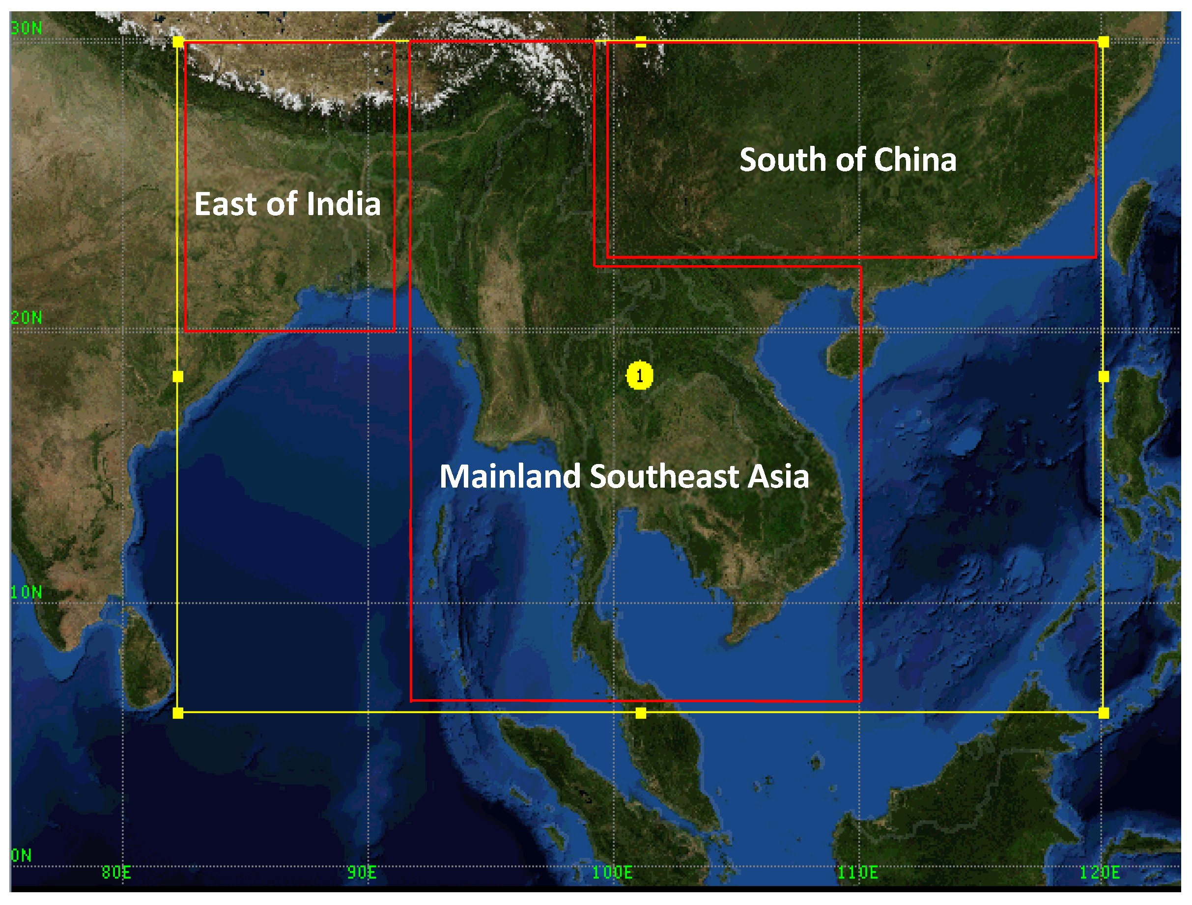
2. Materials and Methods
3. Results and Discussion
3.1. Meteorological and Trajectory Modelling
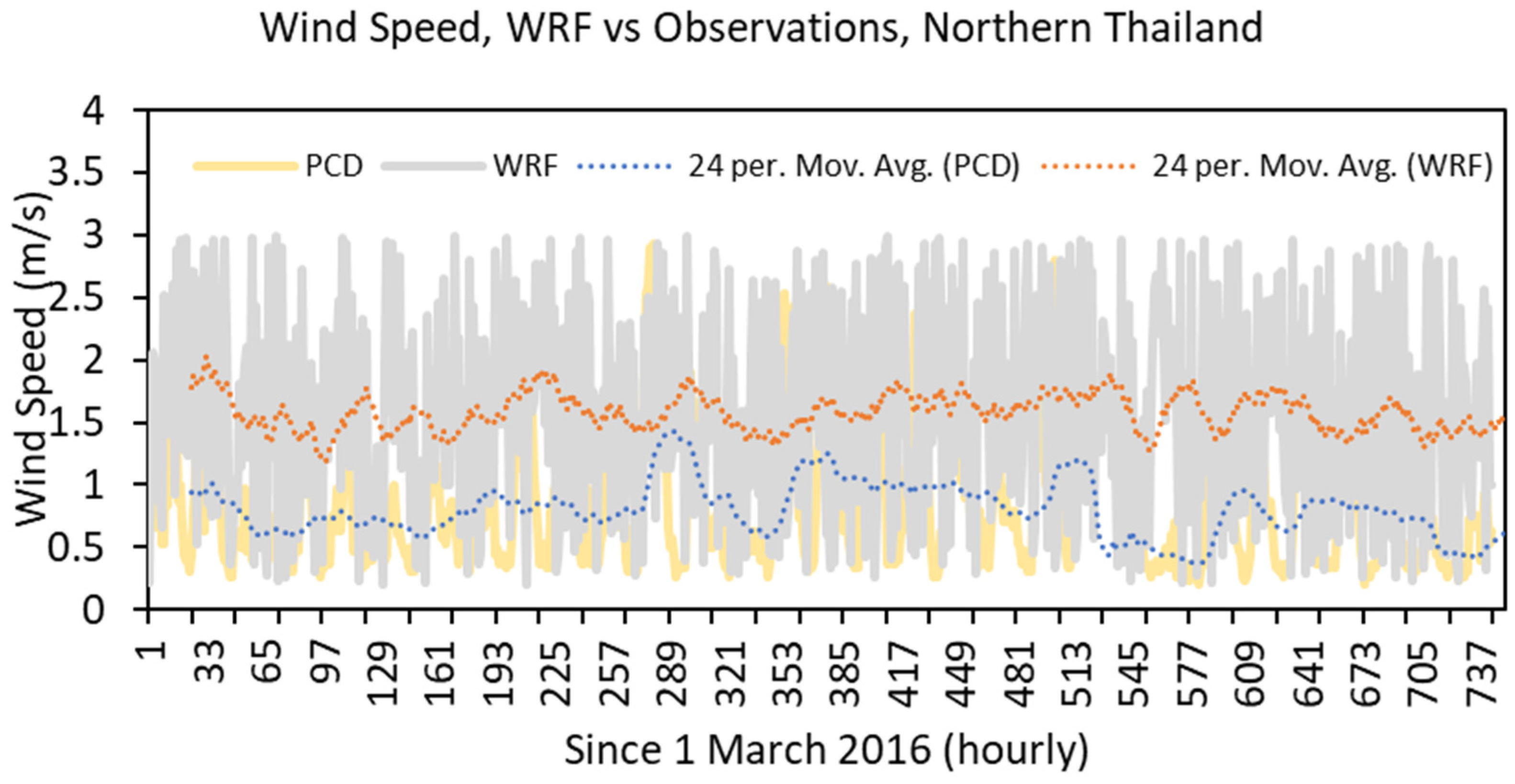
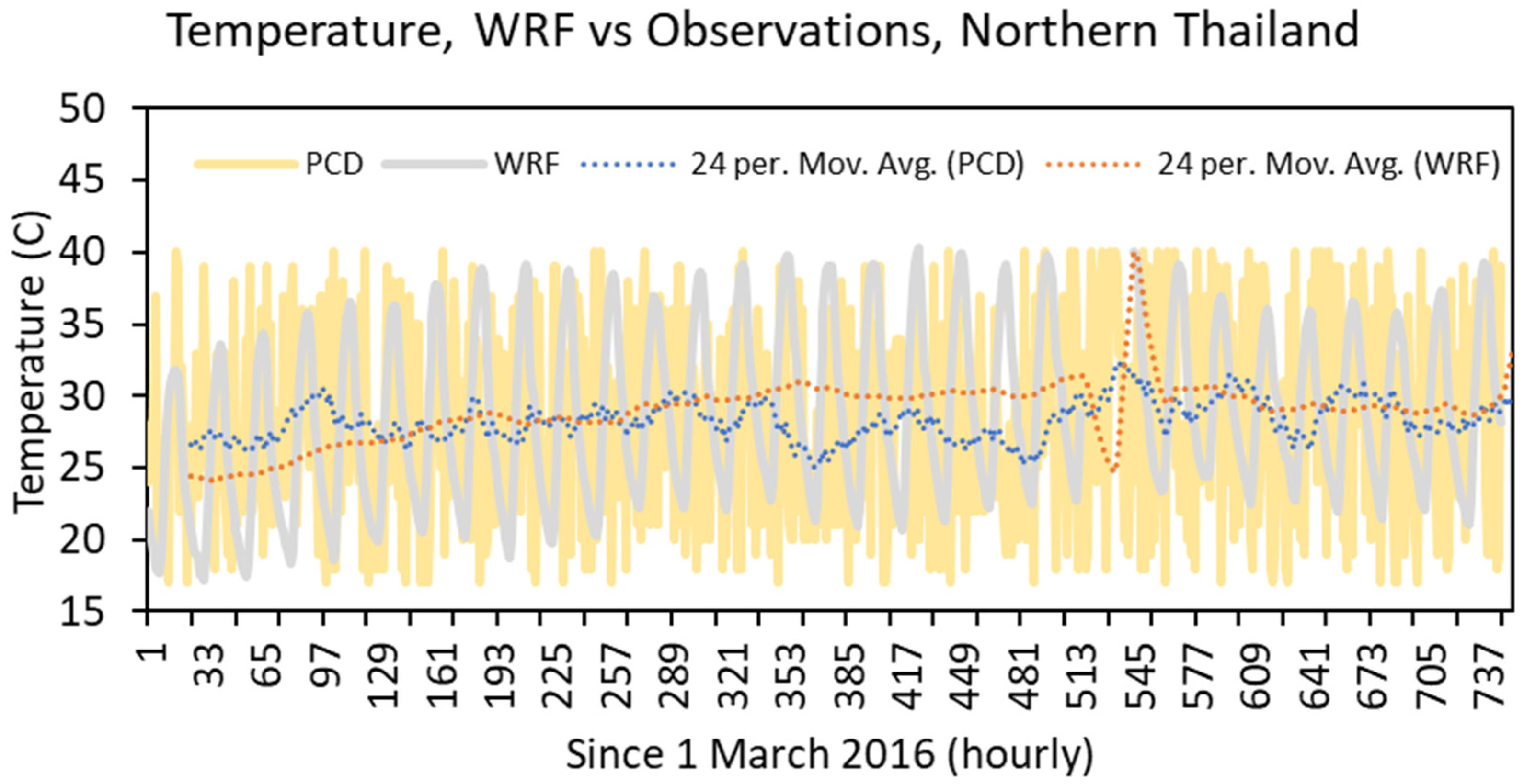
3.1.1. Meteorological Model Evaluation
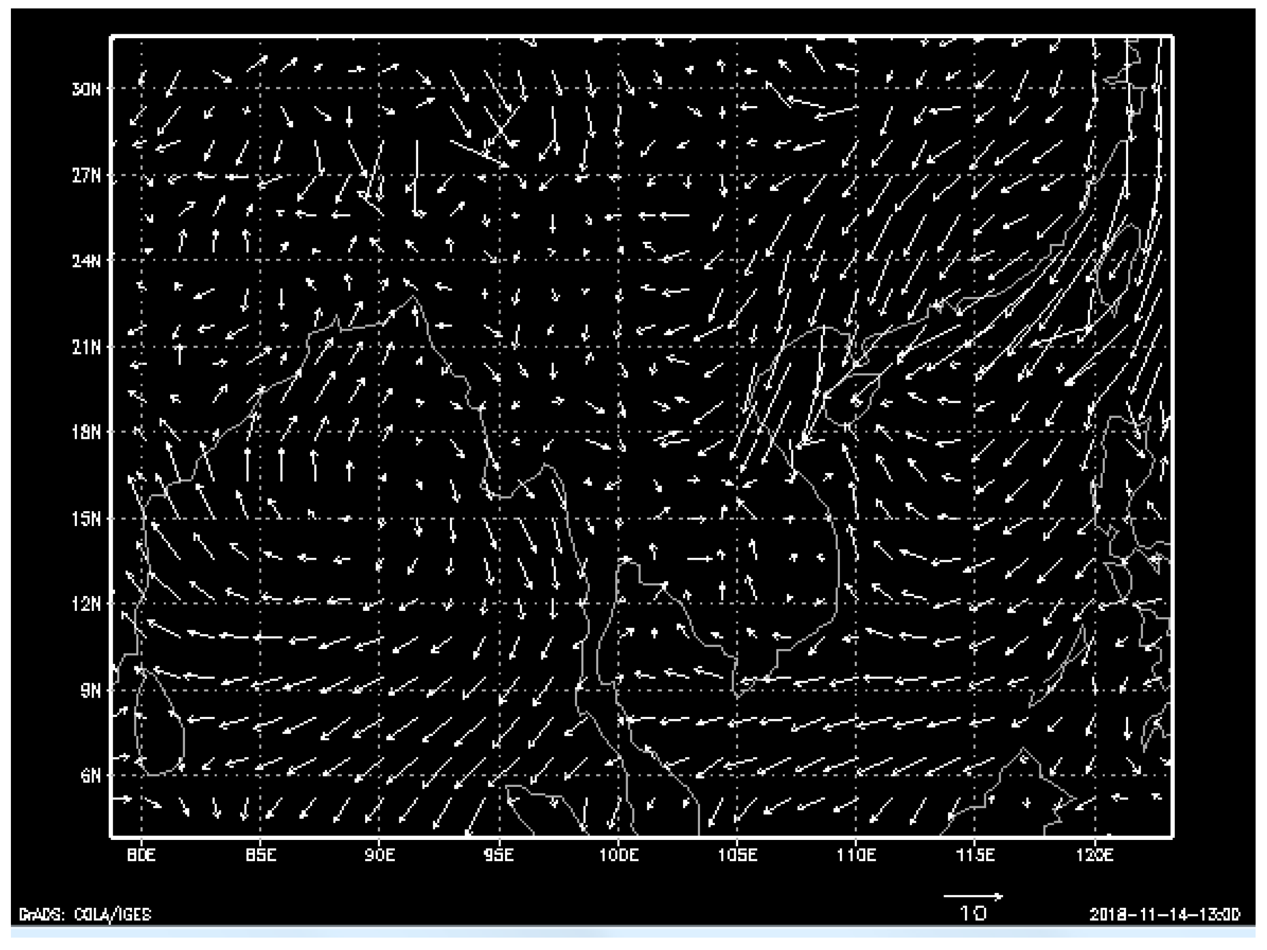
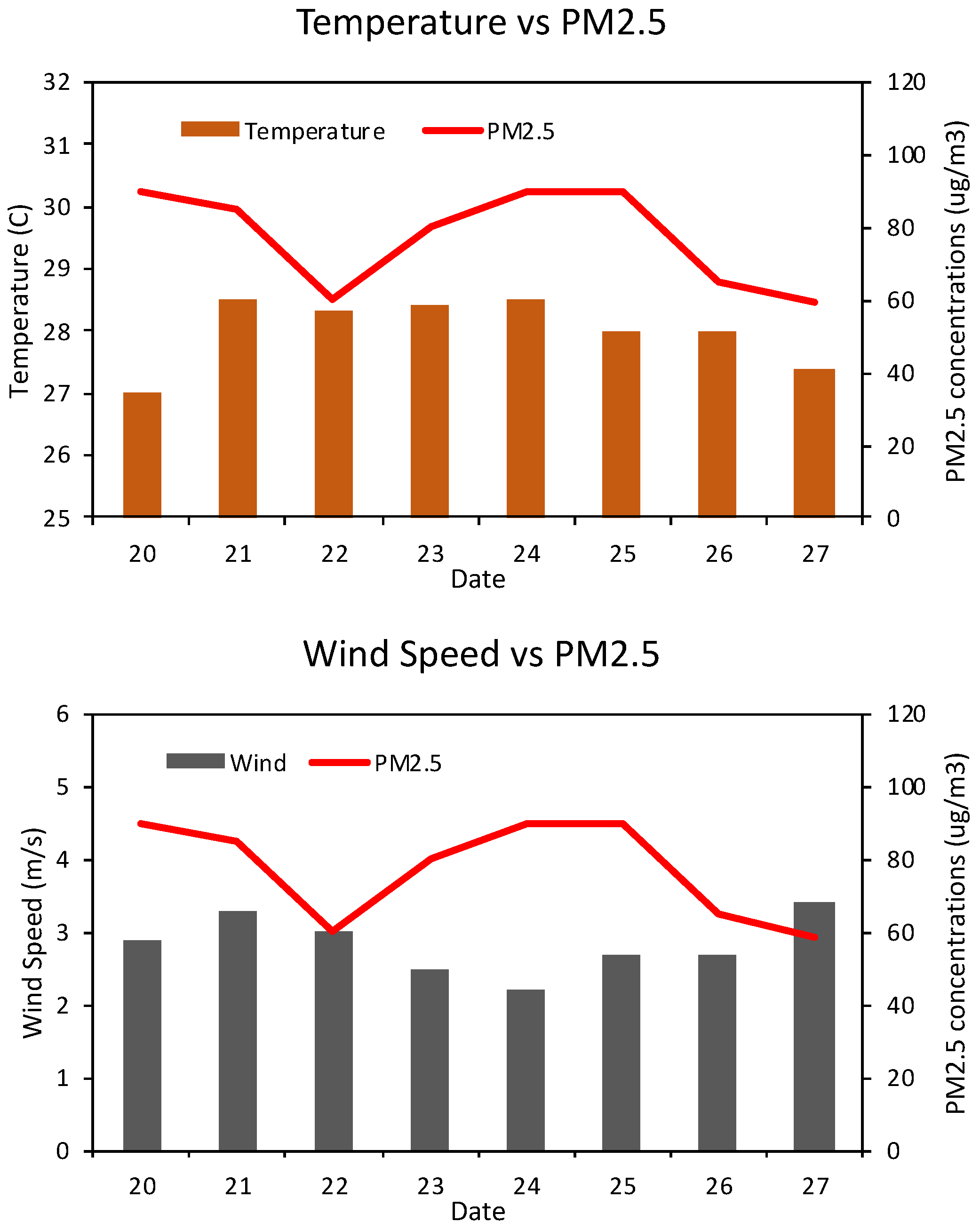
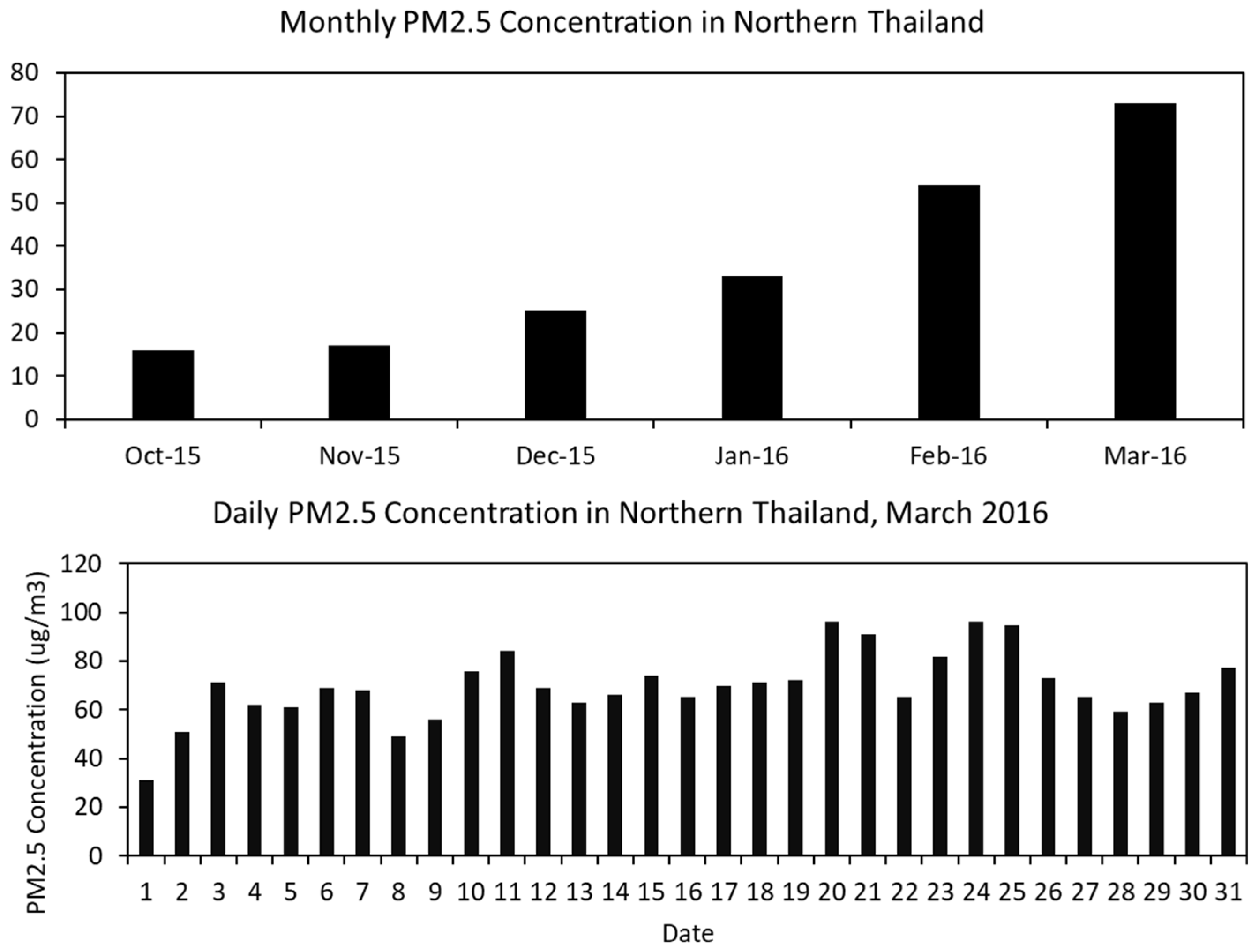
3.1.2. General Meteorology
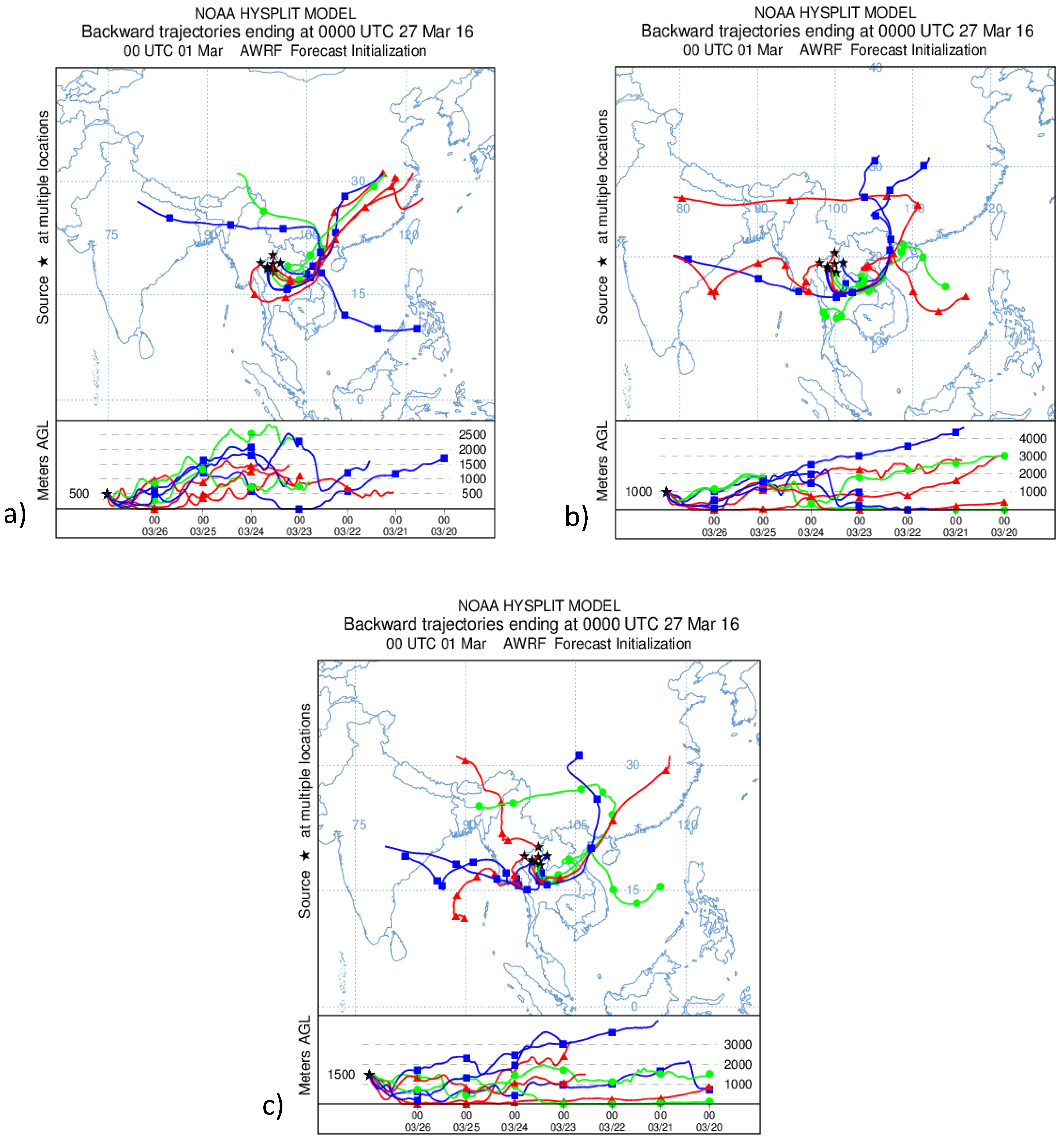
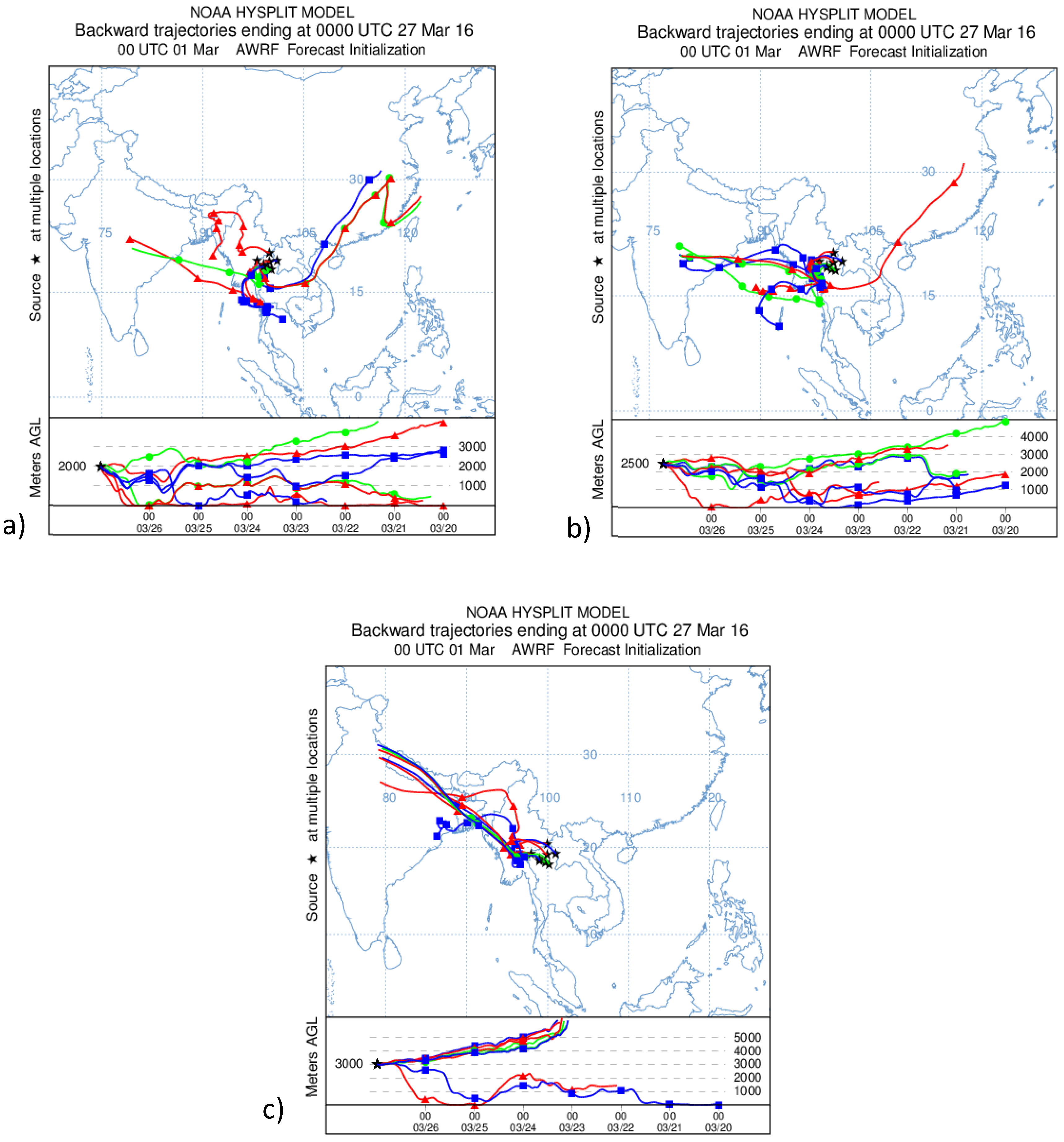
3.1.3. Backward Trajectory
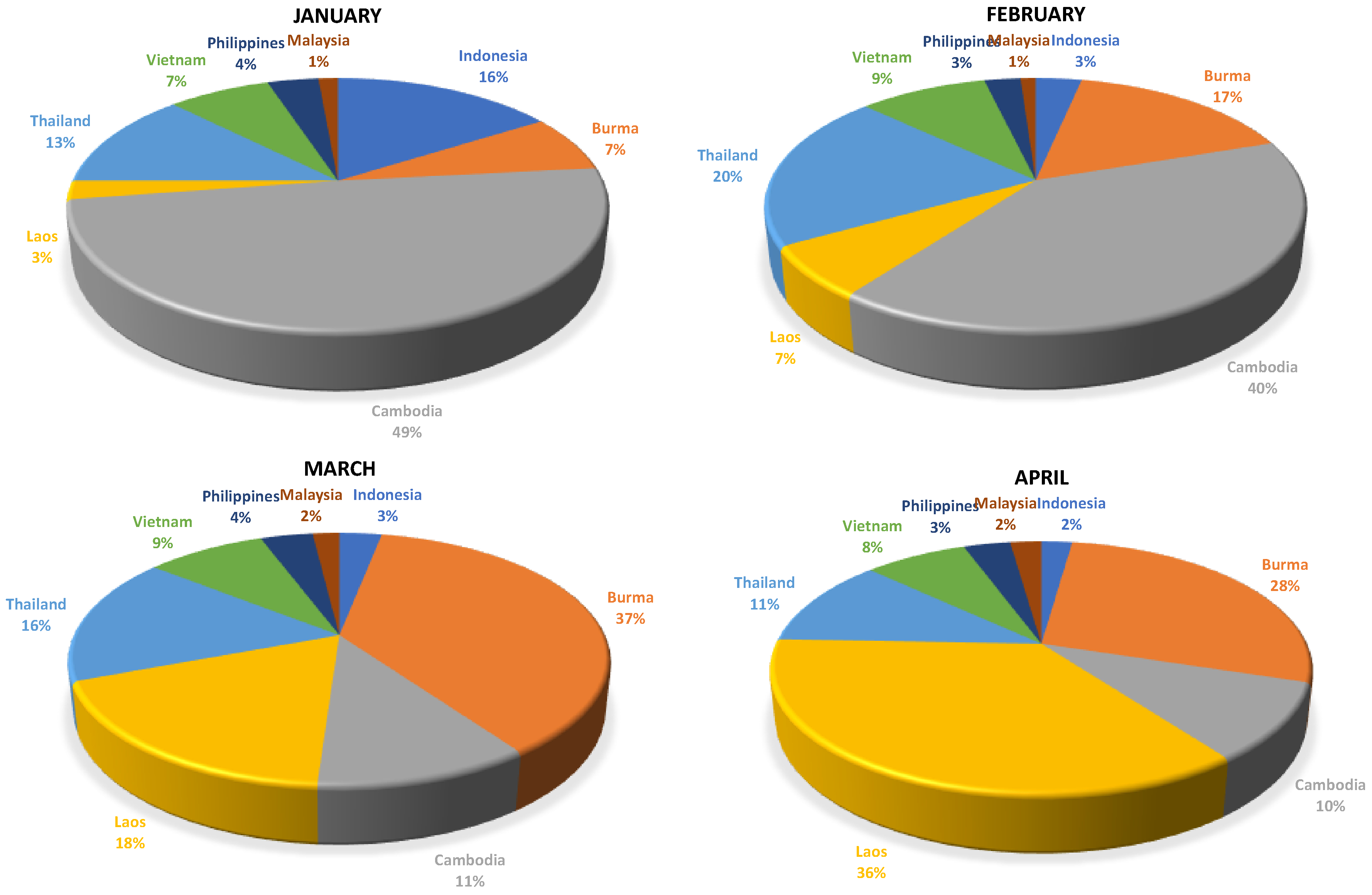
3.2. Hot Spot and Biomass Burning in Southeast Asia
4. Conclusions
Author Contributions
Funding
Acknowledgments
Conflicts of Interest
References
- WHO. 7 Million Premature Deaths Annually Linked to Air Pollution. Available online: http://www.who.int/mediacentre/news/releases/2014/air-pollution/en/ (accessed on 11 November 2020).
- Seinfeld, J.H.; Pandis, S.N. Atmospheric Chemistry and Physics: From Air Pollution to Climate Change; John Wiley & Sons: Hoboken, NJ, USA, 2016. [Google Scholar]
- Yin, S.; Wang, X.; Zhang, X.; Guo, M.; Miura, M.; Xiao, Y. Influence of biomass burning on local air pollution in mainland Southeast Asia from 2001 to 2016. Environ. Pollut. 2019, 254, 112949. [Google Scholar] [CrossRef] [PubMed]
- Lee, H.H.; Iraqui, O.; Gu, Y.; Yim, S.H.L.; Chulakadabba, A.; Tonks, A.Y.M.; Yang, Z.; Wang, C. Impacts of air pollutants from fire and non-fire emissions on the regional air quality in Southeast Asia. Atmos. Chem. Phys. 2018, 18, 6141–6156. [Google Scholar] [CrossRef]
- Lee, H.H.; Iraqui, O.; Wang, C. The Impact of Future Fuel Consumption on Regional Air Quality in Southeast Asia. Sci. Rep. 2019, 9, 2648. [Google Scholar] [CrossRef] [PubMed]
- Oanh, N.K.; Upadhyay, N.; Zhuang, Y.-H.; Hao, Z.-P.; Murthy, D.; Lestari, P.; Villarin, J.; Chengchua, K.; Co, H.; Dung, N. Particulate air pollution in six Asian cities: Spatial and temporal distributions, and associated sources. Atmos. Environ. 2006, 40, 3367–3380. [Google Scholar] [CrossRef]
- Oanh, N.T.K.; Leelasakultum, K. Analysis of meteorology and emission in haze episode prevalence over mountain-bounded region for early warning. Sci. Total Environ. 2011, 409, 2261–2271. [Google Scholar] [CrossRef]
- Amnuaylojaroen, T.; Kreasuwun, J.; Towta, S.; Siriwitayakorn, K. Dispersion of particulate matter (PM10) from forest fires in Chiang Mai province, Thailand. Chiang Mai J. Sci. 2010, 37, 39–47. [Google Scholar]
- Amnuaylojaroen, T.; Kreasuwun, J. Investigation of fine and coarse particulate matter from burning areas in Chiang Mai, Thailand using the WRF/CALPUFF. Chiang Mai J. Sci. 2012, 39, 311–326. [Google Scholar]
- Thai Meteorological Department. The Climate of Thailand. Available online: https://www.tmd.go.th/en/archive/thailand_climate.pdf (accessed on 11 November 2020).
- Cheng, I.; Zhang, L.; Blanchard, P.; Dalziel, J.; Tordon, R. Concentration-weighted trajectory approach to identifying potential sources of speciated atmospheric mercury at an urban coastal site in Nova Scotia, Canada. Atmos. Chem. Phys. 2013, 13, 6031–6048. [Google Scholar] [CrossRef]
- Amnuaylojaroen, T.; Macantangay, R.C.; Khodmanee, S. Modeling the effect of VOCs from biomass burning emissions on ozone pollution in upper Southeast Asia. Heliyon 2019, 5, e02661. [Google Scholar] [CrossRef]
- Lelieveld, J.; Barlas, C.; Giannadaki, D.; Pozzer, A. Model calculated global, regional and megacity premature mortality due to air pollution. Atmos. Chem. Phys. 2013, 13, 7023–7037. [Google Scholar] [CrossRef]
- Vichit-Vadakan, N.; Ostro, B.D.; Chestnut, L.G.; Mills, D.M.; Aekplakorn, W.; Wangwongwatana, S.; Panich, N. Air pollution and respiratory symptoms: Results from three panel studies in Bangkok, Thailand. Environ. Health Perspect. 2001, 109, 381–387. [Google Scholar] [PubMed]
- Tsai, F.C.; Smith, K.R.; Vichit-Vadakan, N.; Ostro, B.D.; Chestnut, L.G.; Kungskulniti, N. Indoor/outdoor PM10 and PM2.5 in Bangkok, Thailand. J. Expo. Anal. Environ. Epidemiol. 2000, 10, 15–26. [Google Scholar] [CrossRef] [PubMed]
- Jinsart, W.; Tamura, K.; Loetkamonwit, S.; Thepanondh, S.; Karita, K.; Yano, E. Roadside particulate air pollution in Bangkok. J. Air Waste Manag. Assoc. 2002, 52, 1102–1110. [Google Scholar] [CrossRef] [PubMed][Green Version]
- Chueinta, W.; Hopke, P.K.; Paatero, P. Investigation of sources of atmospheric aerosol at urban and suburban residential areas in Thailand by positive matrix factorization. Atmos. Environ. 2000, 34, 3319–3329. [Google Scholar] [CrossRef]
- Chueinta, W.; Bunprapob, S. Elemental Quantification and Source Identification of Airborne Particulate Matter in Pathumwan District; Chemistry and Material Science Research Program, Office of Atoms for Peace: Bangkok, Thailand, 2003. [Google Scholar]
- Leenanupan, V.; Harnvong, T.; Sritusnee, U.; Bovornkitti, S. Elemental composition of atmospheric particulates in Mae Hong Son province. J. Health Sci. 2002, 11, 525–533. [Google Scholar]
- Ebihara, M.; Chung, Y.; Chueinta, W.; Ni, B.-F.; Otoshi, T.; Oura, Y.; Santos, F.; Sasajima, F.; Wood, A. Collaborative monitoring study of airborne particulate matters among seven Asian countries. J. Radioanal. Nucl. Chem. 2006, 269, 259–266. [Google Scholar] [CrossRef]
- Ebihara, M.; Chung, Y.; Dung, H.; Moon, J.; Ni, B.-F.; Otoshi, T.; Oura, Y.; Santos, F.; Sasajima, F.; Wee, B. Application of NAA to air particulate matter collected at thirteen sampling sites in eight Asian countries: A collaborative study. J. Radioanal. Nucl. Chem. 2008, 278, 463–467. [Google Scholar] [CrossRef]
- Hopke, P.K.; Cohen, D.D.; Begum, B.A.; Biswas, S.K.; Ni, B.; Pandit, G.G.; Santoso, M.; Chung, Y.-S.; Davy, P.; Markwitz, A. Urban air quality in the Asian region. Sci. Total Environ. 2008, 404, 103–112. [Google Scholar] [CrossRef]
- NCAR. NCEP FNL Operational Model Global Tropospheric Analyses, Continuing from July 1999. Available online: https://doi.org/10.5065/D6M043C6 (accessed on 11 November 2020).
- Skamarock, W.; Klemp, J.B.; Dudhia, J.; Gill, D.O.; Barker, D.; Duda, M.G.; Huang, X.-Y.; Wang, W. A Description of the Advanced Research WRF Version 3. NCAR Technical Note NCAR/TN-475+STR; University Corporation for Atmospheric Research: Boulder, CO, USA, 2008. [Google Scholar] [CrossRef]
- Hong, S.-Y.; Dudhia, J.; Chen, S.-H. A revised approach to ice microphysical processes for the bulk parameterization of clouds and precipitation. Mon. Weather Rev. 2004, 132, 103–120. [Google Scholar] [CrossRef]
- Hong, S.-Y.; Lim, J.-O.J. The WRF single-moment 6-class microphysics scheme (WSM6). Asia Pac. J. Atmos. Sci. 2006, 42, 129–151. [Google Scholar]
- Kain, J.S. The Kain–Fritsch convective parameterization: An update. J. Appl. Meteorol. 2004, 43, 170–181. [Google Scholar] [CrossRef]
- Paulson, C.A. The mathematical representation of wind speed and temperature profiles in the unstable atmospheric surface layer. J. Appl. Meteorol. 1970, 9, 857–861. [Google Scholar] [CrossRef]
- Dyer, A.; Hicks, B. Flux-gradient relationships in the constant flux layer. Q. J. R. Meteorol. Soc. 1970, 96, 715–721. [Google Scholar] [CrossRef]
- Webb, E.K. Profile relationships: The log-linear range, and extension to strong stability. Q. J. R. Meteorol. Soc. 1970, 96, 67–90. [Google Scholar] [CrossRef]
- Beljaars, A.C. The parametrization of surface fluxes in large-scale models under free convection. Q. J. R. Meteorol. Soc. 1995, 121, 255–270. [Google Scholar] [CrossRef]
- Zhang, D.; Anthes, R.A. A high-resolution model of the planetary boundary layer—Sensitivity tests and comparisons with SESAME-79 data. J. Appl. Meteorol. 1982, 21, 1594–1609. [Google Scholar] [CrossRef]
- Draxler, R.R.; Hess, G.D. An overview of the HYSPLIT_4 modelling system for trajectories. Aust. Meteorol. Mag. 1998, 47, 295–308. [Google Scholar]
- Kantha, L.H.; Clayson, C.A. Small scale processes in geophysical fluid flows. Int. Geophys. Ser. 2000, 68, 883. [Google Scholar]
- Wurps, H.; Steinfeld, G.; Heinz, S. Grid-Resolution Requirements for Large-Eddy Simulations of the Atmospheric Boundary Layer. Bound. Layer Meteorol. 2020, 175, 1–23. [Google Scholar] [CrossRef]
- Jones, A.M.; Harrison, R.M.; Baker, J. The wind speed dependence of the concentrations of airborne particulate matter and NOx. Atmos. Environ. 2010, 44, 1682–1690. [Google Scholar] [CrossRef]
- Giglio, L.; Schroeder, W.; Justice, C.O. The collection 6 MODIS active fire detection algorithm and fire products. Remote Sens. Environ. 2016, 178, 31–41. [Google Scholar] [CrossRef] [PubMed]


| Scheme | Option |
|---|---|
| Microphysics | WRF Single Moment (WSM) 3-class simple ice scheme |
| Radiation | rrtm scheme |
| Surface Phyaics | Duhia |
| Land Surface Model | Noah Land Surface Model |
| Convective | Kain–Fritsch (new Eta) scheme |
| Location | Latitude | Longitude |
|---|---|---|
| Nan | 18.78 | 100.77 |
| Lampang | 18.25 | 99.76 |
| Chiang Mai | 18.78 | 98.98 |
| Station | Temperature | Wind Speed | ||
|---|---|---|---|---|
| The Index of Agreement (IOA) | Fractional Bias (FB) | IOA | FB | |
| Chiang Mai | 0.79 | 2.5 | 0.54 | 2.1 |
| Lampang | 0.66 | 1.3 | 0.46 | 1.5 |
| Nan | 0.57 | 2.4 | 0.32 | 1.2 |
| R | Rs | |
|---|---|---|
| Wind vs. PM2.5 | 0.082 | −0.53 |
| Temp vs. PM2.5 | −0.46 | 0.18 |
| Country | January | February | March | April |
|---|---|---|---|---|
| Indonesia | 3295 | 933 | 1899 | 1524 |
| Burma | 1507 | 4643 | 23,132 | 19,013 |
| Cambodia | 10,149 | 11,408 | 6763 | 6841 |
| Laos | 497 | 1855 | 11,284 | 24,570 |
| Thailand | 2580 | 5730 | 10,275 | 7819 |
| Vietnam | 1520 | 2612 | 5357 | 5094 |
| Philippines | 756 | 736 | 2344 | 2318 |
| Malaysia | 288 | 306 | 1195 | 1535 |
| Total | 20,609 | 28,221 | 62,260 | 68,730 |
| Province | No. of Hotspot |
|---|---|
| Chiang rai | 196 |
| Chiang Mai | 566 |
| Nan | 326 |
| Phayao | 147 |
| Phrae | 471 |
| Mae Hong Son | 795 |
| Lampang | 461 |
| Lamphune | 97 |
| Total | 3059 |
Publisher’s Note: MDPI stays neutral with regard to jurisdictional claims in published maps and institutional affiliations. |
© 2020 by the authors. Licensee MDPI, Basel, Switzerland. This article is an open access article distributed under the terms and conditions of the Creative Commons Attribution (CC BY) license (http://creativecommons.org/licenses/by/4.0/).
Share and Cite
Amnuaylojaroen, T.; Inkom, J.; Janta, R.; Surapipith, V. Long Range Transport of Southeast Asian PM2.5 Pollution to Northern Thailand during High Biomass Burning Episodes. Sustainability 2020, 12, 10049. https://doi.org/10.3390/su122310049
Amnuaylojaroen T, Inkom J, Janta R, Surapipith V. Long Range Transport of Southeast Asian PM2.5 Pollution to Northern Thailand during High Biomass Burning Episodes. Sustainability. 2020; 12(23):10049. https://doi.org/10.3390/su122310049
Chicago/Turabian StyleAmnuaylojaroen, Teerachai, Jirarat Inkom, Radshadaporn Janta, and Vanisa Surapipith. 2020. "Long Range Transport of Southeast Asian PM2.5 Pollution to Northern Thailand during High Biomass Burning Episodes" Sustainability 12, no. 23: 10049. https://doi.org/10.3390/su122310049
APA StyleAmnuaylojaroen, T., Inkom, J., Janta, R., & Surapipith, V. (2020). Long Range Transport of Southeast Asian PM2.5 Pollution to Northern Thailand during High Biomass Burning Episodes. Sustainability, 12(23), 10049. https://doi.org/10.3390/su122310049