Abstract
The purpose of this research is to examine whether eum-taek, a feng shui theory for the dead, can be applied to Korean modern architecture. In the first step, common environmental factors that are valued in both feng shui and ecological architecture were derived, and then this research reviewed how properly the traditional site assessment method evaluated them; for example, metaphorized basic concepts of the evaluation theory based on territorial settings can be applied to evaluate common environmental factors. For the second step, this paper reviewed whether the evaluation method for feng shui presented in the previous step was applied equally between yang-taek and eum-taek theories, investigated the differences between them in general, and derived environmental factors to be utilized for evaluation in the field of architecture. As a result, it was found that the major concepts presented in the previous step have been commonly used evaluation criteria, regardless of the categories from traditional theories. The third step was to simulate whether sites selected by each theory actually have similar environmental conditions. The simulation analysis found that all analysis sites were able to obtain a higher sun exposure time than the Korean average; therefore, it was considered that their locations could have environmental advantage, in terms of solar radiation and thermal environment. The simulation results confirm that the target sites have a living environment that would be easy for humans to live in. Finally, the simulation results confirm that the eum-taek site has a living environment that is comfortable for humans to live in. If studies of the site assessment method are carried out considering yang-taek and eum-taek with different evaluation categories, the modern applicability of feng shui may increase.
1. Introduction
According to the survey data from the 2019 Global Status Report (GSR) by the International Energy Agency (IEA), energy consumption in the building and construction sector accounts for 36% of the entire industrial energy consumption with 39% of total carbon dioxide emissions [1]. This means that much energy is consumed in buildings, and reflecting the eco-friendliness of the building has become an essential element, rather than simply a preference. As a result, the application performance of policies and systems to reflect eco-friendliness in buildings has become increasingly important.
These policies were implemented with the Leadership in Energy and Environmental Design (LEED), Building Research Establishment Environmental Assessment Method (BREEAM), Comprehensive Assessment System for Built Environment Efficiency (CASBEE), and Green Star [1]. They show various attempts, such as reflecting user feedback and reflecting traditional architectural views, in order to efficiently reflect their regional characteristics [2,3,4,5]. As a result, the eco-friendly building certification system in each country has prepared assessment tools that can evaluate the surrounding environment of buildings, topography, and vegetation. In particular, the case of the ecological environment is classified as an essential certification item, and the evaluation of the ecological environment reflects the properties of the land, such as the slope of the land, and the quality of the soil [6,7]. This situation shows the result that it is possible to improve the assessment performance of the building evaluation system, and to suggest detailed appraisal methods through the study of traditional architectural theory.
However, Korea’s Green Standard for Energy & Environmental Design (G-SEED) does not properly apply regional characteristics to the system [8,9]. As of 2014, the G-SEED evaluation contents include the areas of ‘land use’ and ‘ecological environment’ that can evaluate regional characteristics. However, in the detailed criteria of ‘land use’ and ‘ecological environment’, there are no evaluation criteria for determining the regional characteristics of the land [10]. This phenomenon means that Korea’s G-SEED needs a policy attempt to reflect regional characteristics. This means that research into conventional architectural theories is needed to increase the application performance of G-SEED and that it is possible to increase the performance of G-SEED as an evaluation tool through cases of each country’s research.
Feng shui is a traditional architectural theory that is utilized in Korea. It is a typical theory that can be referenced to reflect regional characteristics of the modern architecture system. In Korea, baesan-imsu (the concept of residence position which was built with a mountain at the back and a river in front), nam-hyang (south orientation), and myeong-dang (best position), which are universal concepts for selecting the location and planning of a building that originate from feng shui [11,12,13]. However, this classical evaluation method is perceived as an unscientific architectural idea based on ideological content and superstition, because unscientific concepts, such as the genius loci, are mixed in the evaluation elements of the theory [14]. However, the theoretical concepts are also mixed with scientific concepts. Those from the conventional theory, for example, baesan-imsu and jeonjeo-hugo (low front and high rear area), are reflected in regional characteristics according to the geographical location of the Korean Peninsula. They were also used in a way that natural conditions were beneficial to the human living environment [15]. Various academic studies are being conducted to extract and verify effective scientific concepts inherent in feng shui theory, and as a part, research results through scientific approaches are emerging [16,17,18]. These studies can increase the possibility of the institutional reflection of concepts considering the regional value of the ancient evaluation method.
Previously, the scope of research on feng shui was limited mainly to the theory of yang-taek, which selects land for living people, while academic research on the concept of eum-taek is in slow progress. That phenomenon is due to the universal recognition that the yang-taek theory deals with space for the living, while eum-taek theory is the theory of selecting space for the dead [19,20]. However, if the investigation looks at the size and topography of the space of each region selected through both theories, this study can distinguish the categories of topography that can be judged by them. In fact, the areas selected through theories for present residents often choose flat topography, such as the basins and plains surrounded by mountains. In addition, the areas selected through the theory for the deceased mainly consist of slopes, such as hills [21,22]. The difference between these selected sites results from the different requirements of the living and the dead. Tombs value ease of management and preservation, while housing considers resource acquisition and convenience in life, because the living must find an environment suitable for survival, while the dead do not demand it [22,23,24]. Therefore, the fundamental difference between eum-taek and yang-taek arises from the aim of using the site, and the use of the five basic evaluation elements of feng shui can be seen as a common point.
However, since modern buildings have a lifeline (like water and gas supply) to acquire resources, it is possible to form residences in areas such as slopes and hills. This means that even sites that were not suitable as residential areas in the past should now be evaluated as living zones. In other words, applying feng shui to the modern architecture system with only the research of the theory of living may not evaluate the regional characteristics of the terrain. Therefore, in order to examine the possibility of ancient evaluation methods being applied to modern architecture, it is necessary to reflect both theories together. Accordingly, this research aims to explore the modern applicability of eum-taek theory in feng shui thought as summarized in Figure 1.
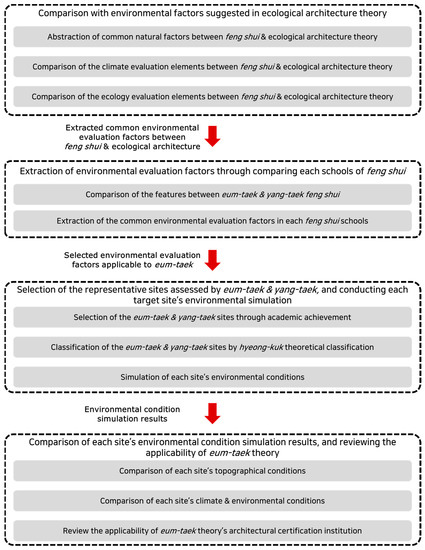
Figure 1.
Research steps.
As the first step in the research, the criteria used for the environmental assessment of feng shui and the environmental factors suggested in the theory of ecological architecture are compared. This is to confirm whether the environmental factors of the traditional method can objectively evaluate the local environment, and to check whether the environmental factors derived through this can be scientifically verified.
The second step identifies the similarities and differences between the two types of estimation tools for conventional sites, based on previous research. In the process, this research compares the two theories to examine whether they use the same evaluation criteria. Finally, this study derives the environmental factors of the evaluation criteria implied in the eum-taek theory.
The third step consists of reviewing the environmental similarity of the selected myeong-dang site according to each traditional theory. Analysis cases are selected from sites selected through both theories, and 3D modeling comparison and simulation of terrain, climate, and environmental conditions are performed. Based on this, the topography, climate, and environmental analysis of both target sites are compared. Finally, this research compares each analyzed result, and examines whether the Korean classical method of choosing a tomb site can be applied to the Korean building certification system.
2. Assessment Indices
2.1. Comparison Environmental Factors between Two Land-Use Theories
Feng shui can be seen as a set of principles of a school that summarizes the theories of where people can live comfortably, such as geographical location [24]. Feng shui uses a tool termed pae-cheol (a site assessment compass), or analyzes the shape of sites and regions for local assessment. This analysis method is based on empirical thinking, and is mixed with non-scientific content, being influenced by social ideology [25]. However, the factors that are finally assessed can be recognized as sunlight, thermal environment, wind environment, eco-system, and topographical structure. These are appraised by methods such as sunlight analysis, wind tunnel test, and landscape analysis in ecological architecture theory. This phenomenon can be the basis for the argument that the original purpose of feng shui and ecological architecture theory are similar, and that the same environmental factors are evaluated. However, there seems to be a difference in the position of dealing with the environment of the two theories. Therefore, this research compared how traditional assessment theory deals with topographical and environmental factors and how the universal standard used when evaluating the site differs from the ecological building theory.
Korean site assessment theory universally uses the concept of hyeong-kuk with ideas of dragon (龍 in Chinese), cave (穴), sand (沙), water (水) and orientation (向) to evaluate the ground based on topographic shapes and environmental conditions, such as mountain ridges, rivers, and topography. Dragon means mountains form and arrangement, while cave indicates the space where the building is built. Sand signifies the environmental elements around the building space, while water refers to the space where it can be obtained around the building. Finally, this study introduces the notion of orientation that calculates the open and closed directions of the site to ensure the benefits of the weather [24]. Therefore, in this research, the investigation selected the hyeong-kuk indices mentioned above as general criteria for feng shui as comparative objects of ecological building theory.
Hwang (2004) and Yoo (2014) extract the environmental factors evaluated between the standards as a common comparative factor for the purpose of comparing the evaluation standards of traditional land-use and ecological building theory. Both studies compare the site selection method between eco-architectural theory and feng shui, and each research effort is conducted in the way of analyzing the intention of use by deriving common site evaluation factors that appear in both theories. As a result, they derive common evaluation factors used for specific target site selection factors and present the corresponding evaluation factors as sunlight, wind, direction, terrain, eco-system, and water space, respectively [25,26,27,28]. In this research, the comparative factors set in the previous research were used as the main environmental indicators for comparing the evaluation criteria of feng shui and ecological building theory.
2.2. Examination of Detailed Weather Factors
The sun provides natural light to the building’s outdoor space, affecting the building’s thermal, light, and shadow environment. Therefore, the sun is generally considered from the location of the building to the sides of the component and, as a result, is controlled by the building elements, such as windows and sunshades [29]. The wind affects the thermal and indoor air quality environment by eliminating the heat from the room through the supply and exhaust, discharging the polluted air, and improving the quality of the air [30]. Each theory applies a method to improve the environmental performance of a building by providing a space into which wind from the building’s total process can flow [29,31]. Its direction is used as evidence that can take advantage of the weather and environmental properties of the area where the building is located. Through the discussion of directions, it is possible to block or prevent environmental factors that can excessively flow into the building environment [31].
2.3. Examination of Detailed Environmental Factors
Terrain means the shape of land, and, by maintaining the shape of the land, they intend as far as is possible to not destroy the ecosystem formed on the existing land. These attitudes are common to both the structural theory of ecosystems and feng shui theory. Considering the fact that the ecosystem may play a protective role as a wall blocking the elements of nature and environment flowing into the building, it is possible to understand the importance of the ecosystem in the two theories [31]. The composition of small ecosystems is also an environmental element utilized in each architecture theory from the same perspective as terrain. Both theories have the same goal of minimizing environmental degradation and integrating buildings into the existing ecosystem [29]. Water space is a source from which aquatic resources can be acquired, and it also serves as an environmental coordinator that directly and indirectly controls the environment of buildings. Therefore, the element is recognized in both theories as a major environmental factor for environmental regulation [29].
2.4. Consideration of Common Evaluation Factors
Feng shui and the theory of ecological architecture have differences in terms of the utilization of environmental factors. The Korean traditional method and ecological architectural theory have differences in terms of the utilization of environmental factors. When selecting a target site, classical architectural theory emphasizes the importance of environmental factors, rather than buildings. However, in contrast, the ecological architecture theory prefers the method of selecting the target site centered on the building, and when the location conditions are not appropriate, transforming the surrounding environment [25,28]. Therefore, in folk theory, environmental factors have a higher hierarchy than buildings and play a variety of roles. Conversely, the ecosystem theory recognizes the natural element as one tool that can be used to advantage in creating the environment of the building [25,28,32].
However, the two theories have the common tendencies of the importance of sustainable development and the maintenance of existing ecosystems [25,32]. In particular, the characteristics of utilizing topographical elements and ecosystems as environmental control tools can be seen in the common way that feng shui and ecological architecture treat the topography. Therefore, the theory of Korean traditional assessment can evaluate the climatic and environmental factors of the region. Moreover, it appears to utilize topographical elements in a similar in manner to the ecological architecture theory and ecosystems to create a building environment. Although non-scientific concepts are mixed, they can be regarded as evaluation criteria embedded with scientific concepts that can review local conditions.
2.5. Applicability of Common Evaluation Factors to Eum-Taek Sites
The most basic site types of feng shui are yang-taek and eum-taek. Yang-taek aims to select the site for a living person, while the other aims to find the spot for a dead person [22]. Park (2015) explains that when assessing a target site, the two traditional theories use the same evaluation factor, and the difference between the two theories shows a difference in the physical state of the target site that says bo-guk [33]. The physical characteristics of the site may vary depending on the purpose of use, which varies depending on the target. In the past, the main living spaces were separated by gender, and the spaces according to the characteristics of the residents were composed horizontally, such as a space to welcome guests, and a space for servants [34]. Therefore, a large area is required, and the size of the site is inevitably large. On the other hand, in the case of tombs, the space to be buried is smaller than that of houses. That is also the reason for the small size of the site area. In conclusion, the difference between two theory’s bo-guk varies depending on the purpose of use of the site, and the most remarkable difference between conventional assessment methods, the bo-guk, means the size of the building site. Moreover, Park proved that both theories use the same evaluation method [33] Accordingly, eum-taek can use the same land-use evaluation criteria as yang-taek, and, through this, the site can be assessed.
Classical assessment theory still has the problem that spiritual and scientific evaluation criteria are used in parallel. Therefore, it is necessary to separate the merged spiritual concept, in order to explore the scientific basis and logic applied to traditional theory. However, the step of studying feng shui from various discipline perspectives, such as science, humanities, and sociology, in order to remove only the spiritual element from the integrated concept, must first take place. This is because if the stepwise review is overlooked, the regionality of classic concepts and meaningful factors may disappear, and the spiritual contents be arbitrarily removed. So, it is difficult to proceed with the research at the present stage since this process requires integrated research. Therefore, in this study, the study was conducted as a method to prove the significance of regional land-use assessment through environmental review of the place selected through conventional theory.
3. Evaluations
3.1. Environmental Analysis of Eum-Taek Sites
The evaluation criteria of eum-taek presented in the previous chapter can be assessed individually in combination with respect to environmental and climate factors that have been reviewed theoretically. Then, investigations using numerical data are necessary, in order to confirm it from a more objective standpoint. According to the need for such verification, topography and analyses on the climate and environment were performed for the sites selected through traditional assessment theory. The above analyses were conducted through simulation: first, terrain analysis was progressed through 3D model of the selected area by using Height Mapper, a 3D mapping plug-in, and Atlas as a 3D map generator provided by Orange-Box. For climate analysis, this study drew up graphical clues such as a radiation rose and wind rose using local weather data, and then overlaid them on the map of the analysis site to examine how the climate responds to the topographic characteristics of the analysis site. Then, an environmental condition analysis tool termed Ladybug tools plugged-in to Grasshopper for Rhino3D was utilized, and these simulation results were applied by applying weather data on a 3D map of the site. Finally, a comparative review of the environment in the actual analysis area was conducted.
For sunlight and thermal environment simulations, a representative site was selected among the regions evaluated as yang-taek and set as a target for comparison. If the criteria for land evaluation of both theories for the living and dead are the same, there is a possibility that the sites selected by the two theories have similar environmental conditions. The fact suggests that, as mentioned in the background, they can offset the limitations of the traditional land assessment method towards the application of modern architecture. In addition, these attempts are valuable as basic data for modern application of the aforementioned theory. Therefore, this study compared representative sites selected by two concepts according to the classification of feng shui. In order to compare the two theories, it is necessary to select a universal target site using theory for the living. In addition, the target site showing the smallest difference from the average data of the results of environmental analysis was considered to have environmental universality, and the target site was selected. For these reasons, the comparison site was selected as Nok-U Dang (a typical residential place in the previous research, coded YT-00) having an environment that was closest to the average value of the simulation analysis result. Nok-U Dang is a representative high-class residence of the Cho-seon Dynasty in Korea. It is classified as a place with the best location conditions in Korea, based on the traditional concept of destination selection (Table 1) [29]. Therefore, it can have validity as an object of comparison in terms of the humanities and its social and environmental aspects.

Table 1.
Site outlines [29].
Among the seven factors presented in Section 2, the ecosystem and water spaces where heterogeneous analysis results can appear are excluded from the overall analysis process. It is technically possible to construct 3D modeling of the shape of the site. However, it is practically impossible to construct the same detailed eco-system conditions created in the region. Environmental data, such as trees, soil, and water flow, are difficult to reenact clearly, because they change fluidly. Therefore, analysis of ecosystems and water bodies that cannot be simulated by computer were excluded from the entire process. In the case of wind, the effects of factors dealt with in terms of architectural planning, such as the distribution of vegetation, height of buildings and fences, and position of yards, should also be considered. But this research was executed for the purpose of grasping the significance of the eum-taek in terms of site environment, so it included the step of applying the wind rose to the analysis.
3.2. Selection of Eum-Taek Sites for Analysis
Eum-taek is used to choose a site that build as a graveyard. Therefore, the selected site strongly reflects the unscientific and mental concept. So, for scientific analysis, it is necessary to select a place where academic research was conducted. In the case of a place where academic research has been conducted or attempted, it is possible to grasp whether the place has been damaged or not, so that it is possible to determine whether the criterion for the traditional assessment is clearly applied. In addition, the fact that academic research has been conducted can be used as a basis to prove that the target site has the value of a research object. Therefore, the analysis site was derived from the region where the research was implemented in the classical location research field. The candidate sites that were searched for were selected primarily from 20 places that were academically interpreted among the myeong-dang suggested in the previous individual studies [35,36,37].
The candidate regions selected for analysis satisfy the first condition for analysis. However, classification steps according to type are required, since the conventional concept of location applied to each region is all individual. If there is a unified type of feng shui theory that is applicable to all analytical sites, the analytical sites can be clearly compared. Because traditional site assessment is a complex theory that employs various concepts of land use, it can have differences in the method of evaluating the region and the basic logic. The Hyeong-kuk theory mentioned in Section 1 classifies the types of regions in the form of the five evaluation indices presented above. Therefore, it is possible to select an analysis site that can be clearly compared by performing a secondary classification using the proposed theory as seen on Figure 2.
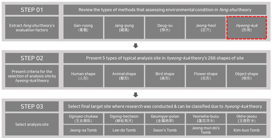
Figure 2.
Method of classifying target sites.
Hyeong-kuk is a study to comprehensively judge the five evaluation elements of feng shui. This theory uses a blueprint that having classified the shapes of all myeong-dang, then judges the similarity of the site shape to be evaluated through this. Therefore, all types presented in this traditional location assessment method were recognized as having an environment suitable for human habitation. The classification of this theory consists of five categories: person (人形 in Chinese), animal (獸形), bird (禽型), flower (花形), and object (物形). Each shape included in the primary category has a total of 264 subtypes through a secondary classification process [38,39]. Since hyeong-kuk evaluates the shape of the region as a whole, it can be considered that the type is classified by including all the detailed evaluation methods used in feng shui theory. Therefore, the above detailed shapes are considered to be a combination of five basic indices that are generally used in Korean land-use assessment theory, and it fills the five common evaluation criteria of the classical Korean assessment method. Accordingly, the final analysis sites in Table 2 were selected from the target area.
Table 2.
Outlines of the selected analysis sites [40,41,42,43,44].
Jeong-sa Tomb (ET-01) is the grave of the father of Jeong’s family. This space is classified as Ognyeo–Chukwa type (玉女側臥形 in Chinese), which means the shape of a woman sitting. Lee-do Tomb (ET-02) is a cemetery in which Lee-do, one of the founders of the Goryeo Dynasty in Korea, is buried. The site has the form of a centipede soaring toward the sky, Ogong–Becheon (蜈蚣飛天). Unusually, as for Lee-do Tomb, the typical tomb faces north. Gwon’s Tomb (ET-03) is known as a representative eum-taek site in Korea and has the shape of a Geumgye–polan (金鷄抱卵形), meaning that the golden chicken is incubated. Jeong-mundo Tomb (ET-04) is classified as Yeonwha–busu (蓮花浮水), a form of lotus floating on water. Kim-bum’s Tomb (ET-05) has the form of Okho–jeosu (玉壺貯水形), in which gold rings are falling into the water [37,38,39]. The selected areas were often located in highlands as seen from the surrounding area, including hillsides and hills.
4. Results
4.1. Topographic Analyses on Target Sites
Terrain analysis was conducted by using the Height Mapper and the 3D Map Generator Atlas to implement the three-dimensional shape of the analysis site and surrounding terrain. For the analysis, it was examined whether the topographical characteristics appearing in the analysis site correspond to the basis of the concept presented in feng shui [24]. The applicable basic concept used a slang word that expresses a good environmental condition used in the Korean traditional concept. The types of expression include baesan–imsu (the site is backed by mountains, while water flows in the front), jeonjeo–hugo (the back of the site is high, while the front is low), deongo–seojeo (the east side of the site is high, while the west side is low), seogo–dongjeo (the east side of the site is low, while the west side is high). The word contains topographic characteristics that are frequently used in conventional assessment concepts. Therefore, it can be seen that the concept of shape is implied in these words. Accordingly, in the topographic analysis process, the study was conducted by assessing whether the shape of site and the expression of words were similar.
In the case of reference area YT-00, the water space flowing from the mountain starting from the south to the northwest, and from the reservoir located to the north, shows the typical baesan-imsu terrain located at the front of the site. In the case of ET-01, a low-altitude mountainous region is created centering on the north of the site, and has a shape similar to baesan-imsu, which is the same as YT-00. In addition, since it shows the shape of jeonjeo-hugo, a topographical characteristic that forms the south-facing and high-altitude north-facing regions, it has a geographical advantage that is advantageous for sunlight incidence. In ET-02, three sides of the target area are surrounded by mountains. It also has the characteristics of jeonjeo-hugo, and like ET-01, it has favorable conditions in terms of sunlight incidence. ET-03 also shows the topographical characteristics of jeonjeo-hugo like ET-01 and 02, and Seogo-dongjeo (low right with high left area) topographical features, due to the mountain range formed in the northwest centering on the land. ET-04 maintains a relatively flat terrain due to the distance from the foot of the mountain located to the east and west sides of the site. However, it can be classified as baesan-imsu type, due to the mountains located at the rear of the site. ET-05 has the most similar shape to YT-00 and is located on a hill formed by a mountain range. As a result, the properties of forest and front and rear elevation appear as shown on Table 3.
Table 3.
Topography analysis of the feng shui approach to target sites.
According to Table 3, even though each target site has individual terrain conditions, good land features, such as baesan-imsu and jeonjeo-hugo, are considered important features of yang-taek. This means that the shape condition for obtaining environmental benefits is applied to the site evaluation using eum-taek. This is based on the fact that all the analysis targets of different altitudes are open to the south. In terms of topography, it was judged that the site to be analyzed can display the properties that match the terrain conditions that are emphasized by feng shui.
4.2. Climatic Analyses of the Target Sites
For climate analysis, after producing the radiation rose and wind rose based on the weather data for each region, tracing was performed on the 2D Map of the region to analyze the climate conditions of the analysis site [29,45]. If it is difficult to apply because the climate data of the region is missing or is out-of-date, the climate data of the nearby region was borrowed. At the set of the analysis time, the radiation and wind rose were drawn in the summer (June to September) when cooling is important, and the winter (November to February) when heating is important. The main analysis data of the radiation rose was to examine the direction in which solar energy flows the most, and the total amount of radiation. Moreover, data about wind direction where the wind blows the most and wind speed were analyzed in the wind rose. As a final step, by tracing the seasonal rose diagrams and sitemaps, we checked what role the topographic features that could be checked on the map could play. Finally, the whole seasonal rose diagrams were projected onto each sitemap, in order to check what role the topographic form on the map played.
The inflow of solar radiation for YT-00 is strongest in the southwest (240°) in summer, and south (180°) in winter. The cumulative insolation was calculated as (215.03 and 214.61) kWh/m2 in summer and winter, respectively, and it can be seen that there is little fluctuation in the influx of solar radiation according to seasonal change. Because the southwest of the target is lowland, the shape of the terrain does not disturb the inflow of sunlight. Such climate and environmental conditions can be recognized as favorable qualifications for establishing a passive strategy.
In the case of ET-01, strong solar influx is seen in the south (180°) and southwest (220°) regions, in the order of summer and winter. Uniquely, the accumulation of solar radiation is 166.04 kWh/m2 in winter, which is much lower than that of 290.26 kWh/m2 in summer. This can be perceived as an environmental weakness. However, the site has a very narrow fluctuation in the inflow direction of 40° = (180 to 220°). If the building’s main heads that direction, a certain amount of useful energy can be obtained throughout the year. ET-02 is located on the south side of the mountain range and has a high elevation at its back of (210 to 360°). However, the solar penetration direction of the site is deduced to be southeast (130°) in summer and south (180°) in winter, and there is no topographical characteristic that executes as a shield against trespassing excessive sunlight. This can be beneficial to the influx of sunlight into the region. In addition, the point shows the cumulative insolation of sunlight of (187.35 and 250.96) kWh/m2 in summer and winter, respectively. The characteristic of high insolation in winter compared to summer can be recognized as a beneficial condition for residence. ET-03 also has a topographic structure similar to ET-02, and a mountain range is located in the rear direction at (240–30)°. In addition, it can be seen that the accumulation of solar radiation in winter is 319.34 kWh/m, which is about 1.8 times higher than 176.67 kWh/m2 in summer. In this way, the analysis target shows similar characteristics to ET-02 and is expected to have the same advantages in terms of residence. ET-04 and ET-05 are located in the southern lowlands of the hill and have a flat topographic structure, except for the rear side. Therefore, there are no geographical obstacles that can hinder the incidence of the sun. It can be seen that the influx of sunlight in the two sites is 222.51 and 161.91 kWh/m2, respectively, in the summer, but 315.93 and 276.46 kWh/m in the winter, correspondingly.
As a result of the analysis of the insolation at all target sites, it was confirmed that the inflow of sunlight in the winter season was higher than that in the summer season in more than half of the targets. Although ET-01 showed lower solar insolation in winter than in summer, it also showed a characteristic of narrow fluctuation in the inflow direction. This can be regarded as an environmental characteristic that is beneficial to the influx of solar radiation throughout the year as described in Table 4.
Table 4.
Radiation rose analyses for target sites.
The wind of YT-00 occurred mostly in the north direction (N) throughout the year. The frequency of wind inflow in winter is 34.07%, which is about 20% higher than 13.89% in summer. Even with these numerical results, it seems that a defensive element is needed on the north side of the site. This can be achieved by mountain ranges that are formed from northwest to southeast. Therefore, it is decided that YT-00 can create a fluid wind inflow environment using the terrain. In ET-01, regardless of summer or winter, the highest wind inflow occurs in the west (W), which appears as 14.92 and 38.69%, respectively. This place is a hilly topography surrounded by rivers on three sides. Since small mountain ranges are formed along the east, south, and west sides, it is possible to control the inflow of wind, as for YT-00. In the case of ET-02, the southeast wind (SE) in summer has the highest influx rate at 17.07%. Additionally, the frequency of wind flowing from the north is the highest at 14.33% in winter.
However, the average wind speed of the northern wind flowing into this place is 0.74 m/s, which is weaker than for the other sites. In addition, because a mountain range is located to the north, there are sufficient defensive conditions to block the wind. ET-03 also has the same geographical utility as ET-02. In summer, the wind blows most from the north and southeast, while the south side has no obstacles. This feature shows ET-03 has the advantage in selecting helpful wind. In winter, the wind from the west-north-west direction is the strongest at 32.14%, but the mountain range located in that direction provides a defense. Therefore, ET-03 can select wind as needed. In the case of ET-04 and 05, the wind blows from a direction close to the north side, regardless of seasonal changes. However, a hill is located on the north side of each target site, and the corresponding topographic element has a shielding function. Therefore, meaningful use of wind is possible in both places. As such, the analysis result was derived that the topographic structure can play the role of shielding wind in all the analysis targets as written in Table 5.
Table 5.
Wind rose analyses for target sites.
Given the results of the climate analysis of all analysis sites, all analysis sites have terrain features that allow selective inflow of the external climate, such as YT-00. In the control of climate factors such as solar radiation and wind influx according to local climate characteristics, the tomb site was also judged to have the characteristic function of climate defense. These results suggest that eum-taek can expand the scope of traditional Korean assessment and reflect the regional characteristics of the building certification system.
As a result of the topography and climate analysis, we could roughly grasp that an analysis target selected using eum-taek can create an environment that is suitable for human habitation. However, the previous topography and climate analysis cannot grasp the specific changes in the environment that can occur when the climate is reflected in the actual topography. Therefore, the effectiveness of traditional theory cannot be only reviewed by the preceding topography and climate analysis. In order to examine the effectiveness of eum-taek, a trend of practical and numerical environmental conditions of each analysis site is required. This research examined the effectiveness of eum-taek by conducting simulations of the light and thermal environments that the sun influences. As specific environmental simulations, sun exposure time, solar radiation analysis, and Universal Thermal Climate Index (UTCI) calculation were performed. All simulation analysis results were reviewed using universally available data, such as Korea’s average sunshine time, including the simulation results of YT-00, the representative type of yang-taek. In the case of the UTCI, an index is used to examine the feeling of warmth in the outdoor space, which is not a universal thermal environment index. Therefore, the UTCI calculated the values of the cases where the sun’s influence was felt, and those where it was not, and compared the changes in the comfort range of the thermal environment [46,47,48].
4.3. Environmental Analyses on Target Sites
Sun exposure analysis was performed by applying the weather data provided by epwmap.com and the Ladybug & Honeybee Tool of Grasshopper to the 3D model of the target site to extract the Sun Exposure Time [49,50]. In the case of YT-00, it was derived from 10 to 11 o’clock in the summer and 8 to 9 o’clock in the winter, which was the most common averages of the environmental simulation results of the yang-taek site presented in previous research [29]. In the summer, all the targets except ET-03 have more than 1 h of sun exposure time compared to YT-00, and ET-03 also shows the same sun exposure time as YT-00. In particular, ET-04 and -05 showed more than 12 h of exposure in the summer, so it was analyzed to have an advantageous position in terms of energy acquisition. In winter, all target sites except ET-02 and 03 had more than 1 h of sun exposure time compared to YT-00, and an analysis result was found that ET-02 and 03 also had the same sun exposure time as YT-00 as described in Table 6.
Table 6.
Distribution maps of the sun exposure for surrounding environments around the target sites.
Depending on the regional differences, the exposure time of the sun for 1 to 3 h or more differs, depending on the analysis site. However, all analysis sites were found to have higher or similar solar exposure times than YT-00. In addition, all sites were higher than the Korea Meteorological Administration’s 2018 summertime of 7.02 h and wintertime of 5.80 h [51].
Traditional Korean architecture did not use mechanical equipment. Therefore, the place where the sun and wind flowed in was recognized as a good place to live. In fact, these places are advantageous for securing useful resources for living. Moreover, in the case of Korea, because resources were used in a way that phased out the inflow of resources, places with high sunlight hours were preferred as living environments. These intentions are inherent in the conventional assessment tool, and they are still valid in modern times. This suggests that eum-taek can be used to evaluate a slope site with good sunlight conditions, and it is effective in securing energy and creating a living environment.
Next, the analysis of solar radiation environment in each site also utilized the climate data provided by epwmap.com and the Grasshopper Ladybug & Honeybee Tool. Through the expanded EnergyPlus weather STATistics (STAT) data provided in the EPW File, typical summer and winter days were set, and a comfort mannequin overlooking the southward direction was used as an analysis surface to calculate insolation [52]. In addition, the control of environmental factors is very important in this simulation. However, the environmental factors are difficult to control because the analysis sites are different from one another. Therefore, in order to control environmental factors, the analysis time point was selected within a specific range. To set a time, a typical weather week was selected, and the average weather data for five regions were calculated. The next process was to select the analysis day that had the most similar value to the average weather data in the specific timeline. Through this preceding process, the final analysis days of each region were established.
The type of analysis result was classified by using the difference of the solar radiation of the typical summer and winter day. Type A is the case where winter solar radiation is higher than summer, and type B is the opposite of A. In the case of C type, analysis was conducted by setting the case where the difference between summer and winter does not appear. In the case of YT-00, it belongs to type B; and if evaluated only in terms of inflow of solar radiation, it may be perceived as an environment unfavorable for the creation of a human living environment. However, this is overcome by the environmental conditions surrounded by mountains, and the use of passive strategies in architectural plans [29]. This dilemma stems from the feature of classical Korean architecture. Feng shui evaluates the fact that even if certain climate factors are not favorable to human habitation, there are also topographic features that can protect them. So, the evaluation was conducted in consideration of the characteristics of these traditional architectural concepts as shown on Table 7.
Table 7.
Sunlight radiation analyses for target sites.
ET-01, ET-02, and ET-03 belong to Type A. In the case of ET-01, the maximum solar insolation in summer is 891 Wh, while in winter it is 1077 Wh. In the case of ET-01, the amount of solar radiation in summer and winter show the largest difference in value among types belonging to Type A. For ET-02 also, compared to 872 Wh in summer, the incidence of insolation is 995 Wh, which is more than 100 Wh, and it is the same in ET-03. Type A solar radiation has the advantage of creating a warm environment in winter and has the advantage of being able to easily apply solar-related passive strategies, such as sunshade and louver. ET-05 is in the B type and has a solar radiation of (990 and 852) Wh in summer and winter, respectively. These environmental characteristics are based on the geographic characteristics of the region where ET-05 is located. Lastly, ET-04 belongs to the C type, and the maximum value of the solar incidence by hour is 1023 and 1093 Wh in each summer and winter. In the case of ET-05, as in the characteristics of the C type, solar radiation of 1000 Wh or more flows through the year, regardless of the season. The C-type type has the advantage of being easy to utilize a passive strategy that must receive solar energy at all times, because the fluctuation of solar energy flowing in throughout the year is small.
As a result of the sunlight radiation analysis, each target was classified as type A, B, or C, and the majority belonged to type A, with high influx of solar radiation in winter. In addition, it was found that all the sites showed higher winter solar influx than did YT-00. Considering that the influx of solar radiation is an important factor in the winter thermal environment, most eum-taek analysis sites have been found to have an environment with advantages in terms of creating an indoor thermal environment. This means that eum-taek can find sites that are advantageous in terms of thermal environment. In addition, it can be seen as evidence indicating that it is an evaluation tool that can select a site that has an environment favorable for human habitation, in addition to the energy acquisition environment mentioned above.
The purpose of the last environmental analysis is thermal analysis that identifies changes in the thermal environment and changes in the thermal comfort range through the application of solar incidence. The UTCI is an index that increases the precision performance of thermal environment assessment by additionally introducing the influence of wind speed and air pressure from the existing sensible temperature calculation method. Like the predicted mean vote (PMV), it has comfort zones, and a sensible temperature and comfort index can be worked out together. The purpose of this simulation is to appraise the influence of the sun’s thermal environment [53]. Therefore, the UTCI analysis was conducted by dividing the case where the temperature at which solar energy was applied (sun Adjusted UTCI, S.A. UTCI), and that at which it was not applied (Typical UTCI, T. UTCI). Through the resultant data, the degree of increase of the sensible temperature and the amount of fluctuation in the area occupancy of the comfort zone were checked, and then the influence of the sun on the thermal environment was analyzed. The analysis process was performed by comparing the difference between S.A. UTCI and T. UTCI [46]. In the summer, the sun was excluded from the analysis period because, in terms of thermal environment, it adversely affects the human comfort environment. Therefore, the winter period (November to February) when the sun acts as an advantage in the composition of the thermal environment was set as the analysis period. In the case of YT-00, the value of S.A. UTCI is higher than that of T. UTCI by 1.9 °C. Moreover, the range of sections that can be perceived as a pleasant thermal environment in human life increases by about 7% from 7.95 to 14.89%.
The S.A. UTCI of all the analysis sites shows the trend of UTCI increase in the sun’s floating time zone compared to T. UTCI. The average UTCI of all the analysis sites was increased from 0.9 to 2.3 °C, depending on whether solar radiation was applied. All analysis sites except ET-04 have a higher trend of change than the trend of UTCI fluctuation of YT-00. In addition, the comfort zone ratio of S.A. UTCI and T. UTCI in winter increased (7–11%). The target site showing the largest increase rate is ET-01, which shows an increase of about 11% of the Comport Zone Ratio, while the target site showing the smallest increase rate is ET-02, which shows an increase rate of about 7% as seen on Table 8 and Table 9.
Table 8.
Winter Universal Thermal Climate Index (UTCI) results and average temperature for target sites.
Table 9.
Winter UTCI’s comfort zone ratio for each target site.
As a result of the winter UTCI analysis of all the analysis sites, it was found that the trend of change in the sensory temperature by the sun was increasing over all of the target sites. In numerical terms, the UTCI value of all sites increased by at least 0.7 °C, and the comfort zone showed an increase rate of at least 7%. Considering that the YT-00’s comfort zone ratio is 7%, it seems that all the analysis target sites selected through the eum-taek have a warming environment that is seen in the average of the yang-taek site’s environment. The result of the analysis of the thermal environment means that the evaluation method through the conventional tomb selection method can distinguish the site having the advantage in creating the thermal environment and suggests that the environment having the advantage of suitability for human living can be grasped.
5. Conclusions
This research analyzed the climate and environment, including the region and topography of the analysis site. As a result, it was concluded that the eum-taek site has similar environmental characteristics to the general yang-taek site. As a result of the topography and climate analysis, the vocabulary for the traditional assessment theory could be applied to each target analysis site. In addition, the analysis site was equipped with topographical conditions to defend against the climate characteristics of the region. The solar influx in many places had an advantage for the living environment, due to the geographical feature that the altitude of the southeast and southwest was low. This means that each analysis site has environmental conditions that have advantages in terms of obtaining solar energy. These analysis results can be seen as a part that works to advantage in creating an indoor warm environment using natural elements.
As a result of thermal analysis, there was a difference in UTCI values between 1.58 and 2.38 °C, depending on the presence or absence of the sun. This means that if humans live on the analysis site, they can feel a temperature of 2 °C higher than the actual. As a result, UTCI’s comfort zone increased from an average of 10.66 to 19.98%. This tendency is similar to the tendency of YT-00, the representative type of yang-taek. Given the difference according to regional features, it is judged that there will be no heterogeneous differences in the environmental conditions between the two traditional assessment theories. The results of this analysis can be seen as evidence that the eum-taek theory can find suitable slopes for residence. Through this, it can be seen that the two feng shui theories can find a site that has an advantage in creating a human living environment in evaluating the site, although the categories of regions that can be evaluated may be different.
Eum-taek, one of the feng shui schools, utilized the concept of evaluating the land from which to create a tomb, has a non-scientific concept, and was perceived as a separate concept from yang-taek. However, because each theory uses the same indices as the evaluation criteria of the land, the environmental conditions of the regions selected through the two theories appear similar. In fact, none of the environmental conditions analyzed in the research showed significant differences, and changes regarding climate showed similar trends. Based on this, the two theories can be used together as the concept of evaluating flat zone and slope zone, respectively, on the same basis. This means that, using feng shui, the scope of evaluating the land beneficial to the human living environment can be widened; furthermore, it is possible to increase the applicability of a classical land-use assessment method to modern architecture through various studies. However, this research has limitations in the research results because it analyzed only the light and thermal environments based on solar conditions. Therefore, scientific verification of various environmental factors referred to in theoretical consideration of conventional land-use theory should be continuously attempted.
Author Contributions
Simulation design and setting, S.-J.C. and S.-H.H.; evaluation performance, S.-J.C.; simulation data analyses, S.-J.C. and S.-H.H.; analysis data result verification, S.-H.H.; paper writing, S.-J.C. and S.-H.H. All authors have read and agreed to the published version of the manuscript.
Funding
This research was funded by Ministry of Land and Transport Affairs of Korean Government (Project No.: 20AUDP-B128638-04).
Acknowledgments
This research was supported by a grant from Urban Architecture Research Program (Technology Development of Design and Construction for Large-Space Hanok over 10 Meters, Development of Hanok Technology, Phase III).
Conflicts of Interest
The authors declare no conflict of interest.
References
- IEA. Global Status Report for Buildings and Construction. 2019. Available online: https://www.iea.org/reports/global-status-report-for-buildings-and-construction-2019 (accessed on 21 July 2020).
- Oluwatobi, G.; Adekanye, A.D.; Inês, L.A. Federal policy, local policy, and green building certifications in the U.S. Energy Build. 2020, 209, 109700. [Google Scholar]
- Doan, D.T.; Ghaffarianhoseini, A.; Naismith, N.; Ghaffarianhoseini, A.; Zhang, T.; Tookey, J. Examining Green Star certification uptake and its relationship with Building Information Modelling (BIM) adoption in New Zealand. J. Environ. Manag. 2019, 250, 109508. [Google Scholar] [CrossRef] [PubMed]
- Wong, S.; Abe, N. Stakeholders’ perspectives of a building environmental assessment method: The case of CASBEE. Build. Environ. 2014, 82, 502–516. [Google Scholar] [CrossRef]
- Doan, D.T.; Ghaffarianhoseini, A.; Naismith, N.; Zhang, T.; Ghaffarianhoseini, A.; Tookey, J. A critical comparison of green building rating systems. Build. Environ. 2017, 123, 243–260. [Google Scholar] [CrossRef]
- Min, J.S. A Study on Comparison in Green Building Certification System of Korea, US, and Japan: Focus on Non-Residential Green Remodeling. Master’s Thesis, Kongju National University, Kongju, Korea, 2017. [Google Scholar]
- Kim, K.H.; Koo, S.H.; Cho, D.W.; Chae, C.U. An Improvements of G-SEED Standards by Comparing with BREEAM in the UK. J. Archit. Inst. Korea Plan. Des. 2018, 34, 67–76. [Google Scholar]
- Lee, J.H.; Shepley, M. Analysis of human factors in a building environmental assessment system in Korea: Resident perception and the G-SEED for MF scores. Build. Environ. 2018, 142, 388–397. [Google Scholar] [CrossRef]
- Lee, J.H.; McCuskey, M.S.; Choi, J.M. Exploring the localization process of low energy residential buildings: A case study of Korean passive houses. J. Build. Eng. 2020, 30, 101290. [Google Scholar] [CrossRef]
- G-SEED Article 1.1.1. Available online: https://www.gbc.re.kr/app/data/regulation/list.do (accessed on 2 April 2019).
- Ke-Tsung, H. Traditional Chinese Site Selection-Feng Shui: An Evolutionary/Ecological Perspective. J. Cult. Geogr. 2009, 19, 75–96. [Google Scholar]
- Lee, B.S. A Study on the Influential Factors on the Recognition Characteristics of Feng Shui Location Selection Elements. Master’s Thesis, Hanyang University, Seoul, Korea, 2019. [Google Scholar]
- Seong, B.J. Study on the Location of Residential Areas in View of Fengshui. Master’s Thesis, Dong-Eui University, Busan, Korea, 2004. [Google Scholar]
- Ding, Y. Kanyu (Feng shui): A Case of Re-interpretation of the Spirit of Space. In Proceedings of the 16th ICOMOS General Assembly and International Symposium: ‘Finding the Spirit of Place—Between the Tangible and the Intangible’, Quebec City, QC, Canada, 29 September–4 October 2008. [Google Scholar]
- Lawal, M. Integrating natural and cultural heritage: The advantage of feng shui landscape resources. Int. J. Herit. Stud. 2010, 9, 307–323. [Google Scholar]
- Mak, M.Y.; So, A.T. Scientific Feng Shui for the Built Environment-Fundamentals and Case Studies Paperback; City University of Hong Kong Press: Hong Kong, China, 2011; ISBN 978-9629371784. [Google Scholar]
- Tang, L.; Nikolopoulou, M.; Zhao, F.; Zhanga, N. CFD modeling of the built environment in Chinese historic settlements. Energy Build. 2012, 55, 601–606. [Google Scholar] [CrossRef]
- Jun, X. A Framework for Site Analysis with Emphasis on Feng Shui and Contemporary Environmental Design Principles. Ph.D. Thesis, Virginia Polytechnic Institute and State University, Blacksburg, VA, USA, 2003. [Google Scholar]
- Rho, J.H.; Son, H.K.; Kim, H.K. A Study on the Landscape Structure and Meaning of Eight Scenic Views of Yeongsa-jeong Pavilion through the Painting and Poem. Korean Inst. Tradit. Landsc. Archit. 2017, 35, 58–68. [Google Scholar]
- Sin, C.S. (A) Study on Geomantic Characteristics and Supplementary Appearance of Gongju Area Villages. Ph.D. Thesis, Dongbang Culture University, Seoul, Korea, 2013. [Google Scholar]
- Choi, K.H. A Study on the Form of Hyeol in Feng Shui: Focused on Progenitor’s Graves of the Goryeo Dynasty Era in Yeunggnam Area. Master’s Thesis, Yeungnam University, Gyeongsan, Korea, 2019. [Google Scholar]
- Lim, H.J. A study on Yangtaek and Eumtaek in Mueuigong sect of Yeongdeok Muan Bak’s family in terms of Feng Shui: Focusing on Mueuigong. Master’s Thesis, Yeungnam University, Gyeongsan, Korea, 2018. [Google Scholar]
- Park, S.D. Read Space with Feng-Shui; Pooreungil Press Co.: Gwangju, Korea, 2017; ISBN 978-89-6291-421-4. [Google Scholar]
- Mak, Y.M.; Ng, S.T. The art and science of Feng Shui—A study on architects’ perception. Build. Environ. 2005, 40, 427–434. [Google Scholar] [CrossRef]
- Jang, J.H. The Study of Heaven, Earth, and Man: Ethic Fens-Shui; Yibicom Press: Seoul, Korea, 2016; ISBN 978-89-6245-125-2. [Google Scholar]
- Chang, P.T.; Jung-Hua, L.; Kuo-Chen, H.; Jen-Teng, T.; Perng, C. Applying fuzzy weighted average approach to evaluate office layouts with Feng–Shui consideration. Math. Comput. Model. 2009, 50, 1514–1537. [Google Scholar] [CrossRef]
- Hwang, J. A Comparative Study of the Feng shui Theory and the Ecological Architectural Theory. Master’s Thesis, Konkuk University, Seoul, Korea, 2015. [Google Scholar]
- Yoo, B.S. A Study of Ecological Architecture Design Regarding Feng Shui Theory. Master’s Thesis, Chungwoon University, Hongseong, Korea, 2014. [Google Scholar]
- Choe, S.J.; Han, S.H. Applicability of Feng Shui Thoughts for Sustainable Space Planning and Evaluation in Korea Verified Using Three-Dimensional Digital Mapping and Simulations. Sustainability 2019, 11, 5578. [Google Scholar] [CrossRef]
- Tuck, N.W.; Zaki, S.A.; Hagishima, A.; Rija, H.B.; Zakaria, M.A.; Yakub, F. Effectiveness of free running passive cooling strategies for indoor thermal environments: Example from a two-storey corner terrace house in Malaysia. Build. Environ. 2019, 160, 106214. [Google Scholar] [CrossRef]
- Kim, D.K. The natural environment control system of Korean traditional architecture: Comparison with Korean contemporary architecture. Build. Environ. 2006, 41, 1905–1912. [Google Scholar] [CrossRef]
- Lee, K.S. A Study of Comparison between Ecological Architecture Theory and Yang-Taek Feng Shui Theory. Master’s Thesis, Hanyang University, Seoul, Korea, 2004. [Google Scholar]
- Park, J.H. A Comparative Analysis on the Feature of Logical Construction between Feng Shui for the Housing and the Grave. Korea Res. Inst. Hum. Settl. 2015, 84, 95–109. [Google Scholar]
- Lee, S.H. The Identity of Korean Architecture; Mimesis: Paju, Korea, 2017; ISBN 979-11-5535-116-1. [Google Scholar]
- Ock, H.S. A Study on the Pungsu Landscape of the Myungdang Tomb Sites in Andong Area. J. Korean Geogr. Soc. 2003, 38, 70–86. [Google Scholar]
- Choi, S.J. A Study on a Favorable Change in Fortune of Descendants due to Propitious Sites for Graves from the Middle Period of the Choseon Dynasty. Master’s Thesis, Yeungnam University, Gyeongsan, Korea, 2008. [Google Scholar]
- Yang, B.H. A Study on Favorable Change in the Fortune of the Decendents due to the Propitious Site for the 8 Famous Graves in Korea. Master’s Thesis, Yeungnam University, Gyeongsan, Korea, 2011. [Google Scholar]
- Jeong, M.H. A Study on Hyeonggi Theory for Mulhyeong Theory of Feng Shui. Master’s Thesis, Seoul National University, Seoul, Korea, 2014. [Google Scholar]
- Jeong, J.W. A study on the Types and Characteristics of Hyeol in Fengshui: Focused on Eumtaek. Master’s Thesis, Seoul National University, Seoul, Korea, 2013. [Google Scholar]
- Overall View of the Target Site, Jeong-Sa Tomb. Available online: https://ncms.nculture.org/origin-of-place-names/story/256 (accessed on 13 October 2020).
- Overall View of the Target Site, Lee-Do Tomb. Available online: http://www.poongsoojiri.co.kr/board_sOYv34/20854 (accessed on 13 October 2020).
- Overall View of the Target Site, Gwon’s Tomb. Available online: http://www.poongsoojiri.co.kr/board_sOYv34/19951 (accessed on 13 October 2020).
- Overall View of the Target Site, Jeong Mun-Do’s Tomb. Available online: http://www.poongsoojiri.co.kr/index.php?mid=board_WBeq17&document_srl=11327&listStyle=viewer&page=14 (accessed on 13 October 2020).
- Overall View of the Target Site, Kim-Bun’s Tomb. Available online: https://news.joins.com/article/21732137 (accessed on 13 October 2020).
- Gao, X.; Wang, T.; Li, B.; Sun, H.; Yang, H.; Han, Z.; Wang, Y.; Zhao, F. Investigation of wind turbine performance coupling wake and topography effects based on LiDAR measurements and SCADA data. Appl. Energy 2019, 255, 113816. [Google Scholar] [CrossRef]
- Staiger, H.; Laschewski, G.; Matzarakis, A. Selection of Appropriate Thermal Indices for Applications in Human Biometeorological Studies. Atmosphere 2019, 10, 18. [Google Scholar] [CrossRef]
- Gisele, S.B.; Patricia, R.C.D.; Oscar, D.C. Intraurban Temperature Variations: Urban Morphologies of the Densification Process of Copacabana Neighborhood, Brazil. Climate 2019, 7, 65. [Google Scholar]
- Wu, Z.; Kong, F.; Wang, Y.; Sun, R.; Chen, L. The Impact of Greenspace on Thermal Comfort in a Residential Quarter of Beijing, China. Environ. Res. Public Health 2016, 13, 1217. [Google Scholar] [CrossRef] [PubMed]
- Li, J.; Niu, J.; Mak, C.M.; Huang, T.; Xie, Y. Assessment of outdoor thermal comfort in Hong Kong based on the individual desirability and acceptability of sun and wind conditions. Build. Environ. 2018, 145, 50–61. [Google Scholar] [CrossRef]
- Bakmohammadi, P.; Esmatullah, N. Optimization of the design of the primary school classrooms in terms of energy and daylight performance considering occupants’ thermal and visual comfort. Energy Rep. 2020, 6, 1590–1607. [Google Scholar] [CrossRef]
- Korea’s Average Sunlight Hours in Summer and Winter. Available online: http://www.index.go.kr/otal/main/EachDtlPageDetail.do?idx_cd=1402 (accessed on 12 October 2020).
- Kristian, F.; Di Nunzio, A.; Jacopo, G.; Antonini, E.; Boeri, A. Outdoor Comfort: The ENVI-BUG tool to Evaluate PMV Values Output Comfort Point by Point. Energy Procedia 2017, 111, 510–519. [Google Scholar]
- Universal Thermal Climate Index. Available online: http://www.utci.org/ (accessed on 12 October 2020).


Publisher’s Note: MDPI stays neutral with regard to jurisdictional claims in published maps and institutional affiliations. |
© 2020 by the authors. Licensee MDPI, Basel, Switzerland. This article is an open access article distributed under the terms and conditions of the Creative Commons Attribution (CC BY) license (http://creativecommons.org/licenses/by/4.0/).