1. Introduction
Even relatively simple ecological systems display high levels of variability in their structural elements and functioning [
1] and, therefore, present a formidable challenge for any ecosystem-based management and decision-making process [
2]. An important goal for the development of sustainable environmental policy and ecosystem management is creating a realistic and useful link to scientific knowledge. Unfortunately, there are often disconnections in the flow of knowledge from science (specific) to policy (generic). Here, practical tools that collate various types of data and knowledge, as well as translate between different disciplines, can help to bridge the divide between science and management [
3,
4].
Ecosystem services can be defined as natural ecosystems’ assets and processes—either economic or non-economic—that are a direct or indirect source of wellbeing and satisfaction of material or non-material human needs for present and future generations. Ecosystem services refer to the numerous benefits that humans derive from ecosystems [
5].
These services can be classified in different ways. Existing ecosystem service classifications have been a widely discussed topic [
6,
7,
8] 8 and several systems have been developed over the last 20 years. These services, whether they are supporting, provisioning, regulating or cultural services, create a foundation for socio-economic benefits that people derive from the functioning ecosystems, including recreational, cultural, and aesthetic values.
In light of the current global ecological crisis [
9], many ecosystem services are under threat [
10]. There is an ever-increasing need to value, highlight, and better communicate how ecosystems support human well-being and identify which management practices and policies can help us reach the Sustainable Development Goals (SDGs). As such, ecosystem services can be regarded as a useful concept to integrate the "aims" of different capitals (Natural, Economic, Social, Human) at a systemic level, relevant to the Five Capitals Model of sustainability [
11].
To support innovative ideas, and help the ocean economy transformation towards a greener future, a systematic literature analysis was undertaken for the BONUS MARES project (
Multi-method Assessment for Resilient Ecosystem Services and human-nature system integration. https://sisu.ut.ee/mares/ BONUS MARES has been funded from BONUS (Art. 185), funded by the EU); this quantified the coastal ecosystem services of the Baltic Sea relating to three key habitats: macroalgae, mussel beds, and seagrass. The review identified, following a bottom-up approach not adhering strictly to existing ecosystem service classification systems, the benefits (services) these habitats deliver direct benefits, which current literature often refers to as final ecosystem services, and indirect ecosystem services or ecosystem functions that are important to maintaining ecological equilibrium.
The bottom-up approach has the aim to link habitats and ecosystem functions to ecosystem services. In this context, economists and biologists discussed, through a process of social learning, possible economic and non-economic valuation methods and combinations of these. Both the previous activities were embedded in a web-platform for dissemination and communication—the MARES toolkit—which included a geospatial representation of the heterogeneity of the knowledge of ecosystem services produced by the three habitats and the impacts produced on these services by a multitude human activities, including climate change.
In addition to the systematic quantification of ecosystem services from the scientific literature, the established geospatial decision support toolkit enables the collection of other valuable information from non-academic sources. These can be relevant and reliable even if not peer-reviewed. In fact, these non-academic but scientifically based publications are commonly developed for policymakers. The functionality of the geospatial representation toolkit allows various participants to perform multi-criteria and holistic assessments across multiple dimensions (Natural, Economic, Human, and Social) by proposing integrated methodological approaches combining different methods, economic and non-economic, thereby complementing ecological knowledge with economic aspects in support of decision-making.
The incorporation and harmonisation of primary data from scientific literature, as well as trans-disciplinary knowledge, into the web-based geospatial (GIS) decision support tool project address the primary goal of BONUS MARES to “perform a meta-evaluation for the observation and monitoring of ecosystem services of the Baltic Sea region and an analysis of the strength of science-policy interaction”.
The GIS support tool consists of dynamically linked databases, an analysis engine, and a portal for the systematic geospatial representation and synthesis of the interactions that exist between different ecosystem services and human systems. It also communicates the impacts of possible future scenarios on these services and suggests best practices for assessing ecosystem services. Moreover, the geoportal represents a user-friendly platform for dissemination and communication for the use of stakeholders, policymakers, scientists, and the general public. In order to allow the research community and the stakeholders to make use of the MARES Eco-GAME (Governance Assessment Matrix Exercise) meta-evaluation tool for future applications, the GIS-portal will be maintained and updated beyond the duration of this research project.
This paper first describes theoretically the rationale for the adoption of the MARES toolkit as a support tool for integrating science and for interfacing this with policy and society (
Section 2). In
Section 3, the article provides a practical and instructional overview of the interactive capabilities of the MARES toolkit. In
Section 4, the results from the participatory testing exercise testing of the tool are presented together with a general discussion. Possible future developments are presented.
2. The Rational for a Geospatial (GIS) Toolkit: A First Attempt to Interface Science, Policy and Society Through a Participatory Toolkit for Social-Learning
As highlighted in the introduction, in order to reduce uncertainty and build robustness of future pathways of sustainable development [
12], sustainable environmental policies need to establish links to scientific knowledge that are supported by an appropriate level of scientific consensus. However, this process encounters two main challenges:
- -
the disconnection in the flow of knowledge from the scientific form, very specific and specialised, into the generic and more simplified form, for the use of policy and society [
13] and
- -
the limited integration among different scientific disciplines [
14].
- -
In order to face these challenges, this article presents two main solutions that are integrated into two functions of a geospatial MARES toolkit, described in
Section 2.1 and
Section 2.2 and analysed in more detail in
Section 3.2- -
the first function is meant for a consultation about existing non-economic knowledge on three selected habitats-submerged vegetation, seagrass beds and mussel reefs-and on the ecological functions and ecosystem services these generate.
- -
the second function is for the dynamic interaction of methods or combinations of methods, which can be proposed to support the transfer knowledge for decision making,
In this way, the MARES geospatial toolkit works as an interface for translating and integrating different knowledge types for different users.
2.1. Appraisal of Existing Knowledge, Linking Science, Policy and Society
The conceptual framework as described above has been applied to the coastal areas of the Baltic Sea, a marine region of significant socio-economic importance in the northern hemisphere which can serve as an excellent study case example. In fact, the Baltic stands out for providing a strong scientific foundation and accessibility to long-term data series that enable planning for holistic, sustainable, and forward-looking management [
15]. In the context of marine environments, coastal regions are particularly important worldwide because they have a disproportionately larger population compared to other areas. In addition, coastal regions are a focal point for international transport and trade [
16], which is why the interests of various stakeholders are often the strongest. This puts coastal habitats and ecosystems under direct and indirect anthropogenic pressures that threaten the important ecosystem services they provide [
17].
To address the challenge of disconnection between science and society, the MARES geospatial toolkit contains a consultation function that performs the meta-evaluation of existing scientific knowledge and provides a qualitative assessment. This function is described in detail in
Section 3. This first function of the toolkit, the "Literature review", summarises the results of the first systematic scientific literature analysis which was implemented during the MARES project. It presents the level of Economic, Natural, Human, and Social knowledge associated with the three selected habitats and the ecosystem services that they produce, at the regional level. This method was chosen because of its strength in collecting secondary data, as well as critically appraising and synthesising research studies [
18]. This synthesis enables the linking of existing assessment ecosystem services to the use of economic research and policymaking on environmental management and suggests potential approaches for future research. The function, although not interactive, is dynamic because future updates can be generated by further analyses.
The BONUS MARES bottom-up approach has searched for knowledge linking habitats to final services. The knowledge that can be generated by the systematic literature analysis is limited to publications that can link natural habitats to final services. That which relates to the economic valuation of final services, not linked to specific habitats (mussel reefs, macroalgae and seagrass beds), is not present.
2.2. Participatory Dynamic Integration of Trans-Disciplinary Scientific Knowledge
As much of the existing academic literature on the economic (monetary and non-monetary) valuation of ecosystem services does not refer to the selected habitats, this knowledge was not included in the systematic literature analysis. This is why the data of the systematic literature analysis is planned to be complemented by further knowledge, derived from participatory and referred expert elicitation.
Scientific literature reports that in a system, as well as between systems, the interaction between the component parts is much more important than the parts singularly considered [
19]. The isolation of scientific disciplines and laboratories may reveal to be inadequate to represent the real world, which is characterised by complex interactions between its different sub-systems, failing to describe more objective and complete evidence.
A first expert meeting had highlighted how the choice of different methods for valuing ecosystem services can realise very different results, for instance, market prices resulting only from the isolated approach of equilibrium between supply and demand should be added by the reconstruction cost, when the ecological perspective of maintaining the habitats needs to be taken into account. The reconstruction cost can take habitats and ecosystem functions into account and integrate the assessment with ecological considerations.
In order to face this second challenge of limited integration between scientific disciplines, the MARES geospatial toolkit contains a dynamic participatory framework, developed for the collection of supported expert knowledge on ecosystem service valuation methods. This allows participants to complement the existing knowledge about natural habitats, functions, and ecosystem services provided by the consultation function, and to associate evaluations belonging to other fields of science, in this case mainly economics, but also possibly related to societal choices or human well-being/health. The participant can, in fact, add methods that would be able to include additional dimensions (e.g., Human, Economic, and/or Social capital), thereby improving the overall assessment and integration level between disciplines.
Moreover, this function not only integrates the scientific knowledge belonging to different scientific disciplines, but can also find a place for relevant knowledge contained in non-peer-reviewed, yet reliable material, reports or policy documents, which the initial systematic literature analysis did not include. In this way, the MARES geospatial toolkit gathers all this other kind of knowledge as well, at the sole condition that the source is provided.
2.3. The Functioning of the MARES Geo-Spatial Toolkit
In order to transfer knowledge from different sources, to build trans-disciplinary social learning and to represent complexity without decreasing uncertainty, for the use in everyday life, the MARES toolkit has been planned to work as an interface between different disciplines. Moreover, the toolkit has been planned to interface integrated science with policy and society, in order to make this complexity available for practical use, and especially for individual and collective decision making. The ultimate aim of the toolkit is to support society to orientate choices towards objectives of sustainable human development, represented by the Sustainable Development Goals (SDGs) of Agenda 2030 [
20].
The intention of the MARES geospatial toolkit is to collate various types of data and knowledge as well as translate it among different disciplines, helping to bridge the divide between science on the one side and policy and society (including management) on the other. The toolkit stimulates contributions that would combine a different kind of knowledge and different methods, in order to increase the reliability and qualitative level of evaluations (ecological, biophysical, and economic). Therefore, even in the absence of linkages, methods can be proposed and recalled than in the future in order to be possibly combined with other methods for specific purposes.
The spatial representation, combined with appropriate meta-information, clarifies the multifaceted spatially-explicit knowledge on the studied ecosystem services, as well as their cumulative threats [
21]. Moreover, the outcomes that involve habitats, services produced, and interactions can be spatially analysed for specifically selected regions, such as the Helcom regions (e.g., the Gulf of Finland). These possibilities for spatial analysis give the MARES geospatial decision toolkit a strategic function for informing decision-making about the trade-offs in marine policy and spatial planning.
In order to realise this interface function, the MARES toolkit makes use of the Eco-GAME framework 12, described in more detail in the next subsection.
2.3.1. The MARES Toolkit Central Processing Unit: The Eco-GAME Framework
The MARES toolkit is based on a bottom-up approach, to inform decision-makers about the quality of scientific knowledge for the purpose of natural and human systems’ sustainability, represented by the Sustainable Development Goals (SDGs) of Agenda 2030. This means that the identification of ecosystem services does not refer to existing classification systems. It follows an open approach to the scientific integration of all services and functions directly or indirectly relevant for human well-being and primarily for more objective basic human needs and represented by the Sustainable Development Goals (SDGs).
In line with the principles of multi-dimensionality and indivisibility of the SDGs, the MARES toolkit aims at creating the link that fills the gap between ecology, human well-being, and societal choices. To this aim, the toolkit was built upon an Eco-GAME meta-evaluation framework 12 as represented in
Table 1.
GAME stands for Governance Assessment Matrix Exercise [
22], an evaluation framework of governance for sustainability and social learning that has been further developed and adapted to realise the Eco-GAME for the meta-evaluation of methods for the appreciation of ecosystem services.
The Eco-GAME meta-evaluation is based on expert input and thereby accredited sources of knowledge. The Eco-GAME matrix is similar to a competency matrix with scores ranging from 0 (knowledge gap) to 7 (identification of a future vision and policy to reach UN Sustainable Development Goals). The scores translate a qualitative evaluation into quantitative to facilitate further elaboration, according to the existing literature in competency matrices, such as for instance pedigree matrices [
23]. The participating expert will be called to select attributes that can describe the method, or combination of methods, object of observation.
For the current version of the MARES toolkit, assigning a given attribute automatically implies that the lower attributes are also verified. The meta-evaluation is performed for four capital dimensions: Natural, Human, Social, and Economic (Forum for the Future 2020), described in detail in
Table 2.
In practice, for the first function of the toolkit the researchers analysed existing literature and, in particular, studied how ecological processes produced ecosystem services 22. For this function, the systematic literature analysis is considered as the most effective and can be updated in the future by further rounds on missing literature.
For the second function of the toolkit, to enable easy access and on-line participation, the Eco-GAME meta-evaluation has been embedded in the interactive MARES toolkit. As mentioned in the previous section, this participatory expert elicitation can include non-peer-reviewed, yet still reliable knowledge.
2.3.2. MARES Toolkit Function 1 - Consultation about Existing Information
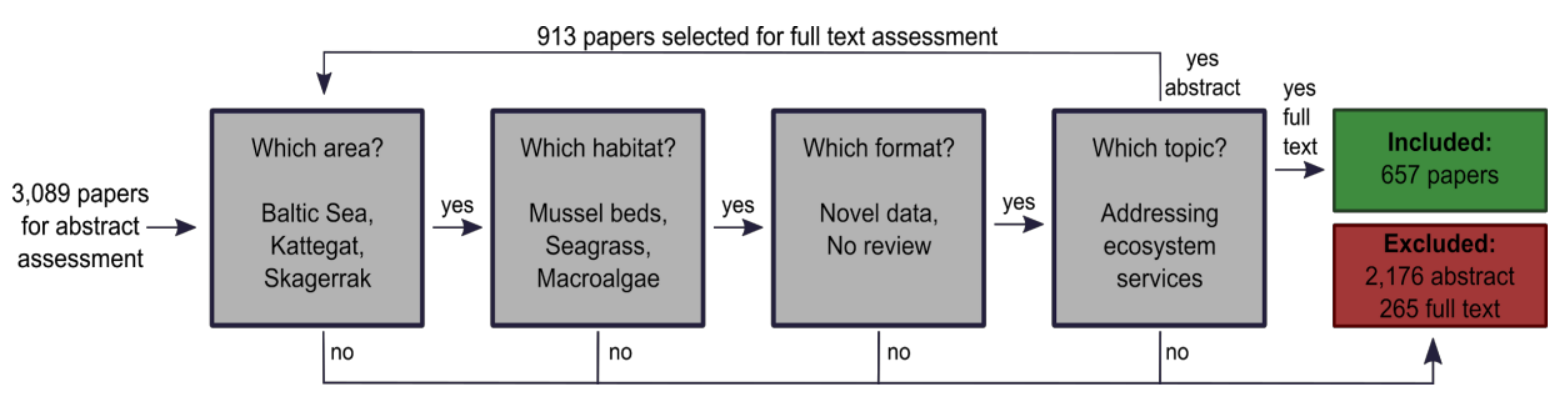
The first function of the toolkit provides quantifiable input data which can be consulted and used for the participatory interaction that takes place in the second. All MARES data can be found and queried on the main page of the geoportal (
http://www.sea.ee/esq/review/main). The current geoportal data layer includes information from published scientific literature, derived from quantitative, statistical methods commonly used in natural sciences, appraised by a systematic literature review (657 scientific publications from the Baltic Sea area) and fulfilling a number of criteria (
Figure 1):
- (1)
Location: studies were carried out in the Baltic Sea, Skagerrak or Kattegat
- (2)
Object of investigation: mussel beds, seagrass, or macroalgae
- (3)
Type of data: original data (e.g., experimental, observational, or modelling but no reviews) and
- (4)
Nature of consequence or implication searched for: addressed ecosystem services or climate change effects on the target ecosystems.
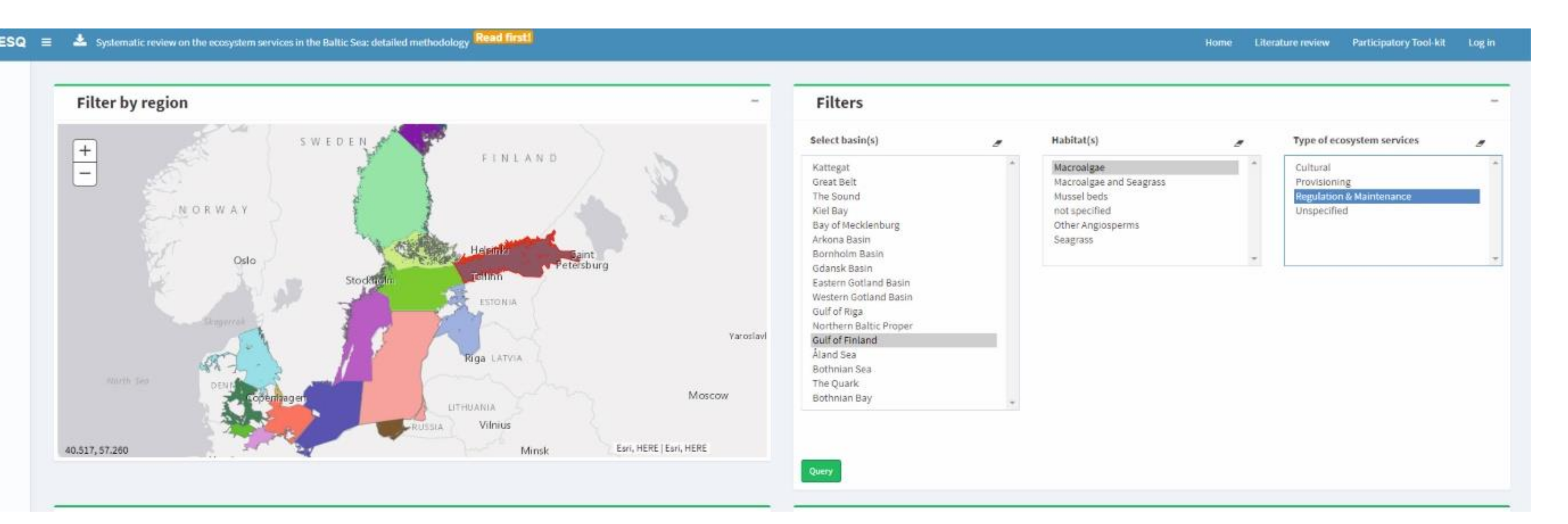
For the consultation, three filters can be specified: the geographic basin of interest (one or multiple) in the Baltic Sea based on HELCOM divisions; ecosystem and type of ecosystem service of interest.
As an example, in
Figure 2 the Gulf of Finland is selected as a study basin (selected study region borders become dark red), and information about the regulation & maintenance of ecosystem services of macroalgae has been sought. Three filters—basins (s), habitat (s), and ecosystem services, in any desired combination, allow the user to filter data across various ecosystems and coastal regions of the Baltic Sea.
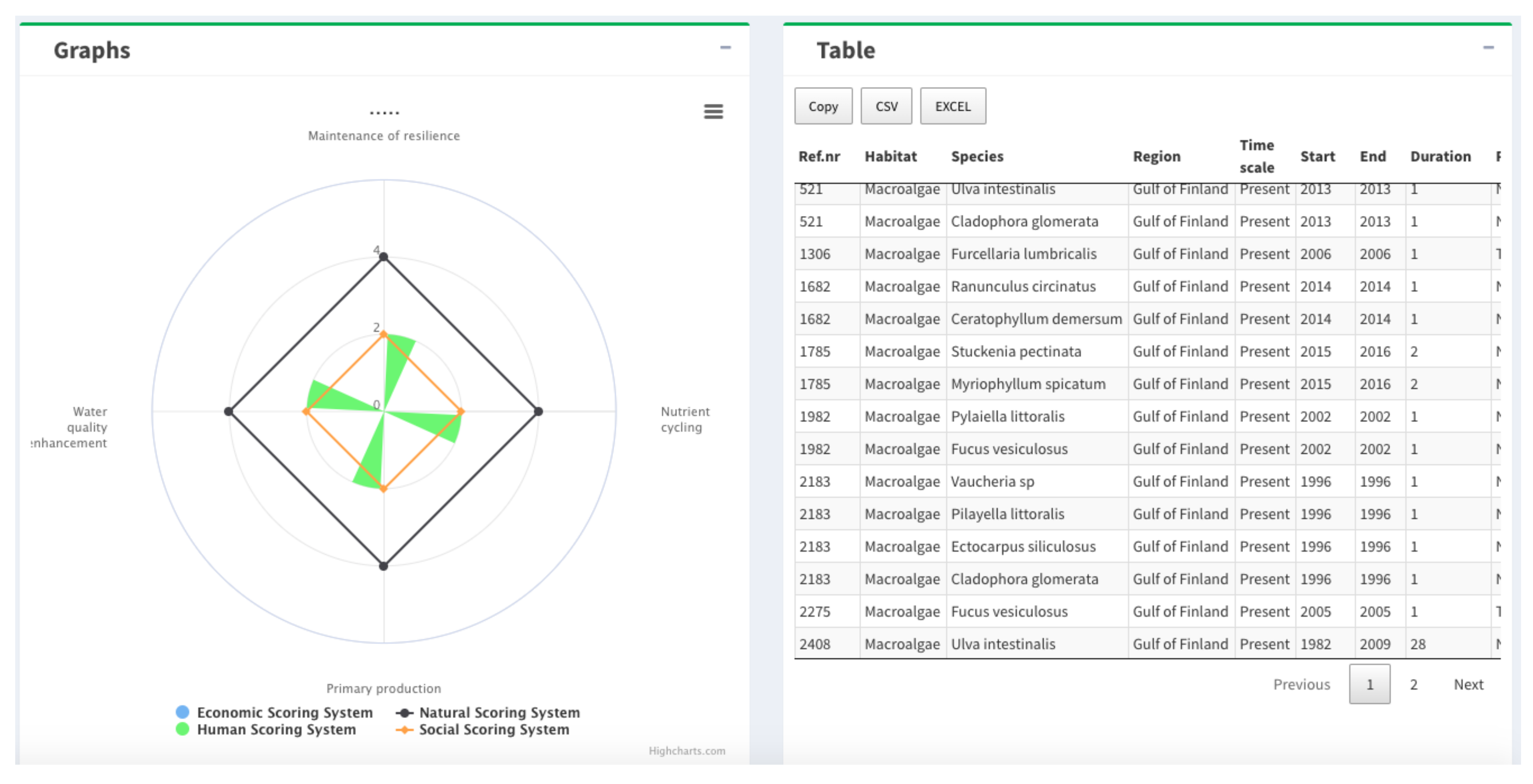
When querying the results, the geoportal will display Eco-GAME matrix results about the current state of knowledge of the user-selected ecosystem services/habitats/regions, as well as knowledge transferred about ecosystem services, through the four value dimensions.
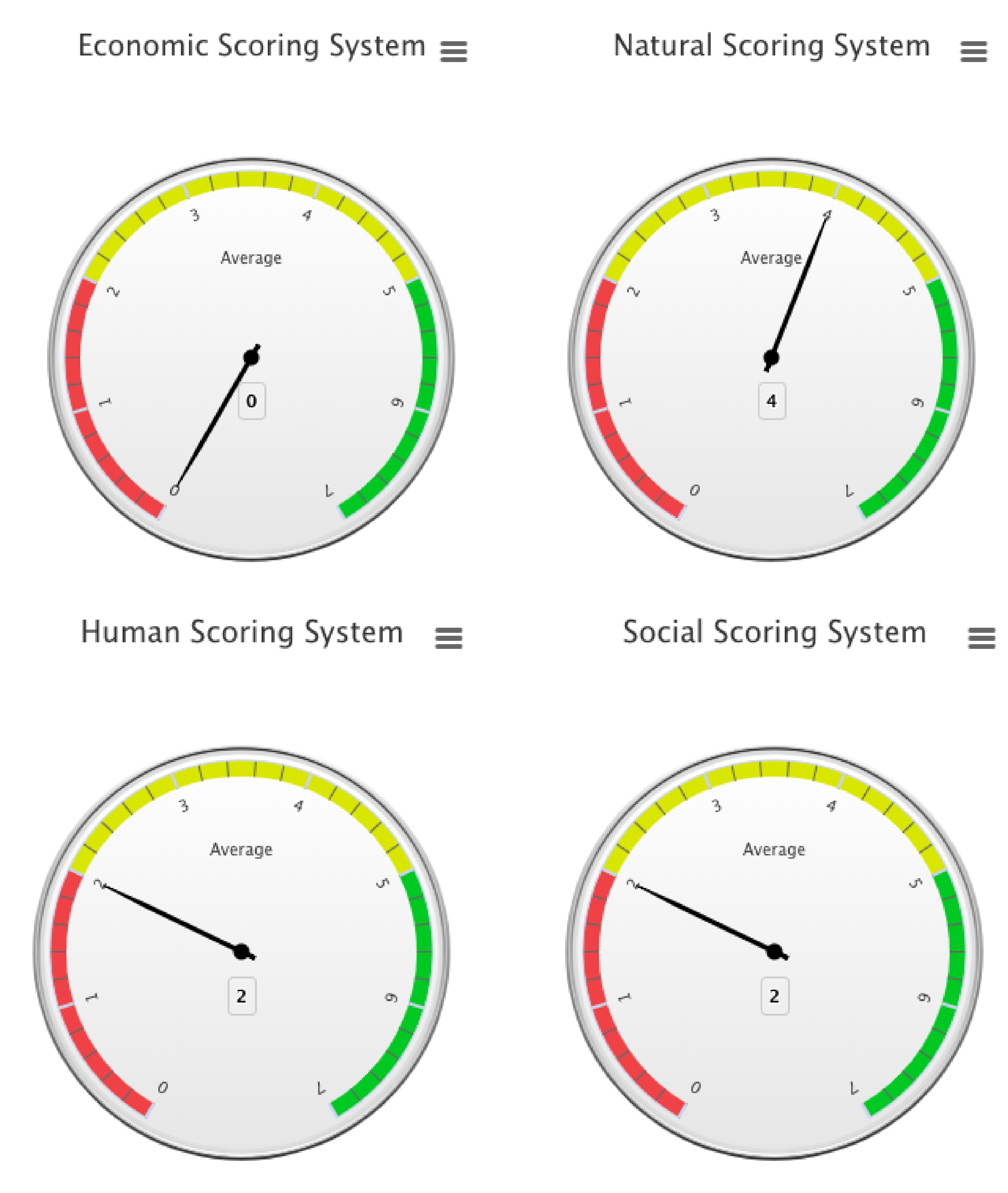
The user can also easily view, access, and download raw data (CSV or Excel) associated with predefined filtering criteria. The first graph illustrates the current knowledge on various ecosystem services along different dimensions (
Figure 3). The user can visualise the Eco-GAME scores as displayed in an aggregated format (Economic, Natural, Human, and Social) for each of the selected ecosystem services (left-hand side of
Figure 3) or in a non-aggregated form by individual scoring circles (0–7) (
Figure 4).
In the example used, the application of the Eco-GAME on the selected literature following a bottom-up approach, in order to assess the level of knowledge integration connecting the ecosystem/habitat (Natural capital) to the produced service (Human/Social capital) and its valuation (Economic capital). Although ecosystem services economic valuation-related knowledge exists, the greatest part of it is top-down, which means that it is related to socio-economics and not attached to the description of the ecosystems or habitats that produced the service. Therefore, the analysis revealed quantitative information about how ecosystems generated the service, but limited knowledge of how this function translates into socio-economic benefits. The second function of the MARES toolkit addresses this by proposing combinations that can increase the qualitative level of the relevant knowledge (see
Section 2.4).
2.3.3. Communication of Threats and Pressures to the Baltic Sea Environment
Another valuable output that is not visually displayed through the Eco-GAME scores but can be found in the downloadable raw data table (right-hand side of
Figure 3) is information related to pressures on ecosystems. This is, for instance, represented by 38 pressures that were assessed a systematic literature review and included both direct (e.g., boating / physical disturbance) and indirect (e.g., acidification, warming) anthropogenic pressures that impacted or are expected to impact upon the ecosystem services.
The geoportal currently shows assessments of approximately 63% of the ecosystem services detected in the Baltic Sea; the most commonly identified pressures included toxins, nutrients, and the changes in salinity and temperature under future climate conditions. It is important to note that the most frequently assessed pressures might not necessarily represent the most severe threats to coastal ecosystems and their services. Information about the negative impacts of pressures on ecosystems and services they provide in the Baltic Sea region can help to guide greener management actions and reduce harmful impacts where necessary.
2.4. MARES Toolkit Function 2—Expert Elicitation on Integrated Evaluation (and Valuation) Methodologies
The Eco-GAME framework applied to the first section recognized that ecosystem service valuation methods are complementary to other assessments (e.g., on the status of ecosystem components). In order to improve the Eco-GAME performances, a web dynamic and participatory interface has been developed (
http://www.sea.ee/esq/participatory/tool) in a second section.
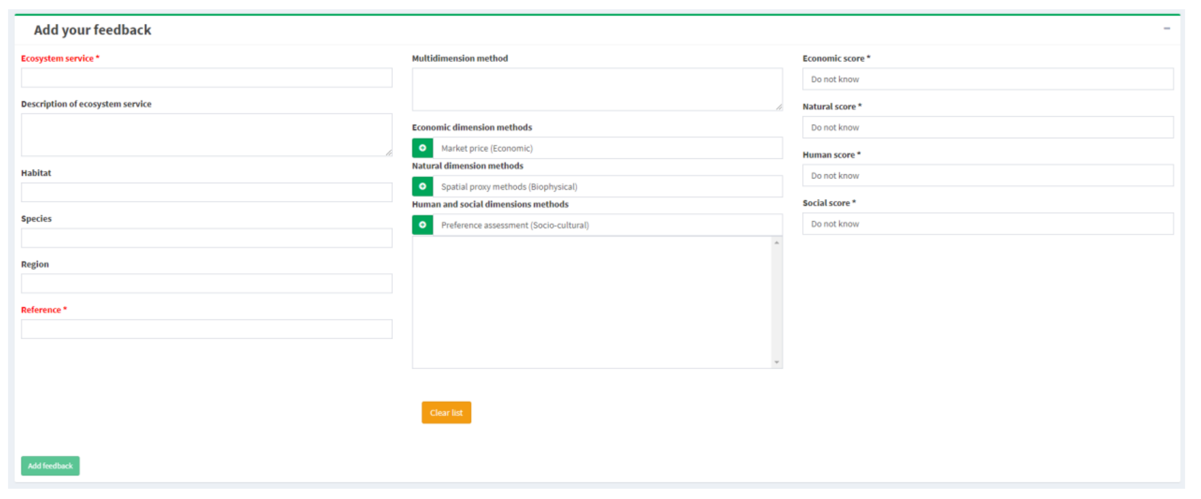
Users are invited to ‘play’ their own Eco-GAME, by inserting knowledge about ecosystem services and related valuation method(s) or their combinations, as well as the level of knowledge achieved. They can assess ‘type’ and ‘amount’ of information available from a range of single or combined approaches (economic or non-economic) and how well they are able to deliver about an ecosystem service in a particular area.
To play the Eco-GAME on the MARES toolkit, follow the steps as listed hereafter (see
Figure 5):
Specify the knowledge about the ecosystem service in the interactive form (e.g., ecosystem service, habitat, species, region).
Click on the green ‘plus’ icon to pick up one or more methods from the existing lists, according to the different capital dimensions. This functionality allows the user to combine methods and add multi-dimensionality. In case you would like to propose a method, which is not listed, provide a separate description for it.
Provide a reference to the knowledge, e.g., a piece of academic or practice-based literature.
For the selected combination of ecosystem service and method(s), provide your assessment according to the Eco-GAME scores (
Table 1) along four dimensions (see
Table 2) on the basis of referred or supported evidence (publication or research done).
Submit the inserted data by clicking “Add feedback”.
In the earlier versions of the geoportal, expert knowledge could also be inserted into the interlinkages of the ecosystem services and relationships between different pressures and ecosystem services – these features have however been removed from the current version of the geoportal and returned to the development phase.
2.5. Interpretation of Results
All users’ results (including their own insertions) can be visualized in tables and graphs of Eco-GAME scores and by the final index.
For each entry, the portal assesses the total amount and quality of information delivered for each capital dimensions (Natural, Human, Social, Economic) by the specific combination of methods (Eco-GAME index; Sajeva et al 2020). This is shown by the formula below, which is an average of the collected inputs (one for each capital), multiplied by the minimum value. This penalizes evaluations which are more discrepant among the considered capitals or have too low values for one of the capitals.
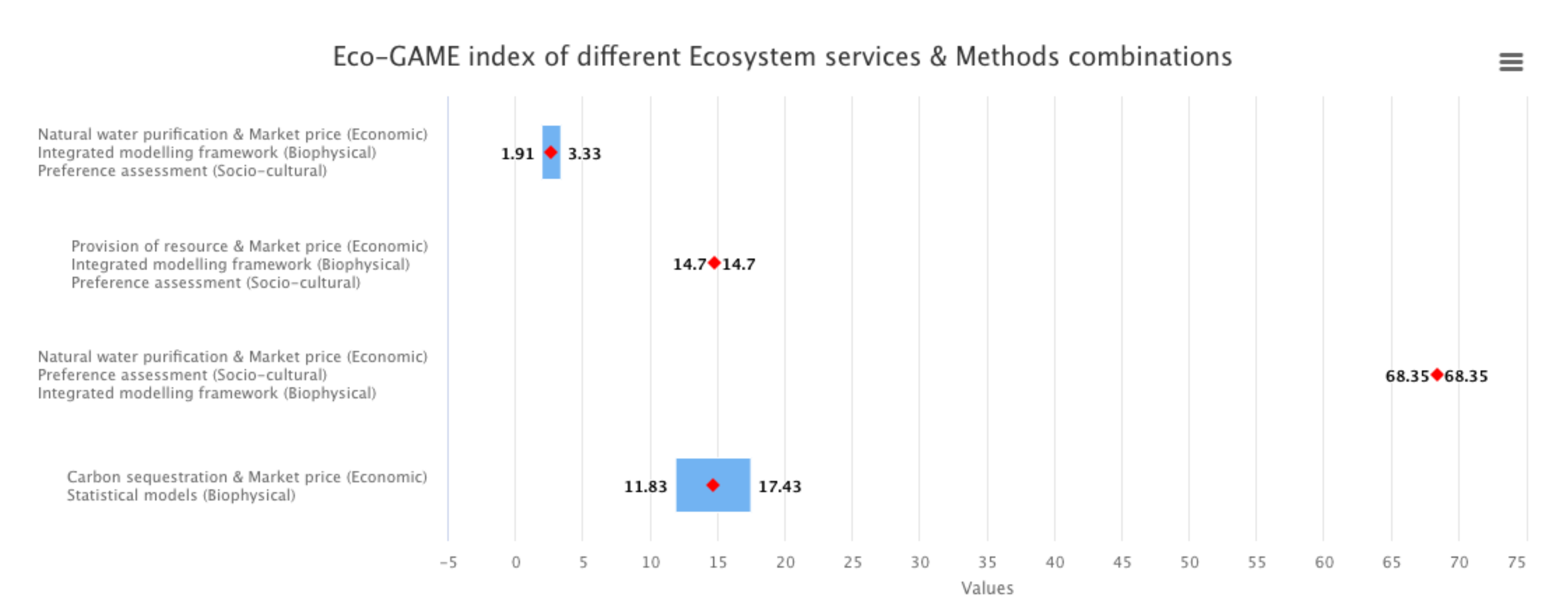
The graph in
Figure 6 summarises the expert knowledge by calculating the average of Eco-GAME indices given for a certain ecosystem service—valuation method(s) combinations. When more meta-evaluations are produced for the same ecosystem service and the same method or combination of methods, these may differ from one another. Therefore, a standard deviation is calculated to appraise the uncertainty of different meta-evaluations.
In this way, the end-users of the portal would be informed about the strength of linkages between different methodologies when assessing performances related to the UN SDGs.
Figure 7 (dependency wheel) gives an example of a graphical output which assesses the strength of linkages among different methods with higher linkages suggesting better synergies among methods to deliver information on various ecosystem services.
Ultimately, the portal informs about the best ways to assess and manage different ecosystem services in order to reach the UN SDGs. The MARES multi-method toolkit serves as a practical framework for the economic and non-economic meta-evaluation of marine ecosystem services in the Baltic Sea area (or beyond) and strengthens knowledge transfer in science policy-interactions about the efficiency of different methods to deliver knowledge on ecosystems services. With time, as the expert knowledge inserted to the toolkit accumulates and can be aggregated, the interpretation of the data will be further developed, in particular paying attention to the needs of the decision-makers at different levels.
The user can also easily view, access, and download raw data (CSV or Excel) associated with expert knowledge.
3. Assessing Economic Knowledge: Opportunities and Challenges for Assessing Valuation Methods through Geospatial Representation
3.1. The Testing of the Eco-GAME by a MARES Simulation Laboratory (MARES SimLab)
The MARES Simulation Laboratory (SimLab,
Figure 8) tested a process of social learning and building of evidence in support of decision making with the participation of a panel of experts (see
Appendix A). To test the different functionalities of the MARES toolkit and to give feedback, both on its usability and contents, participants were grouped according to the four capitals, and as representatives of key societal actors.
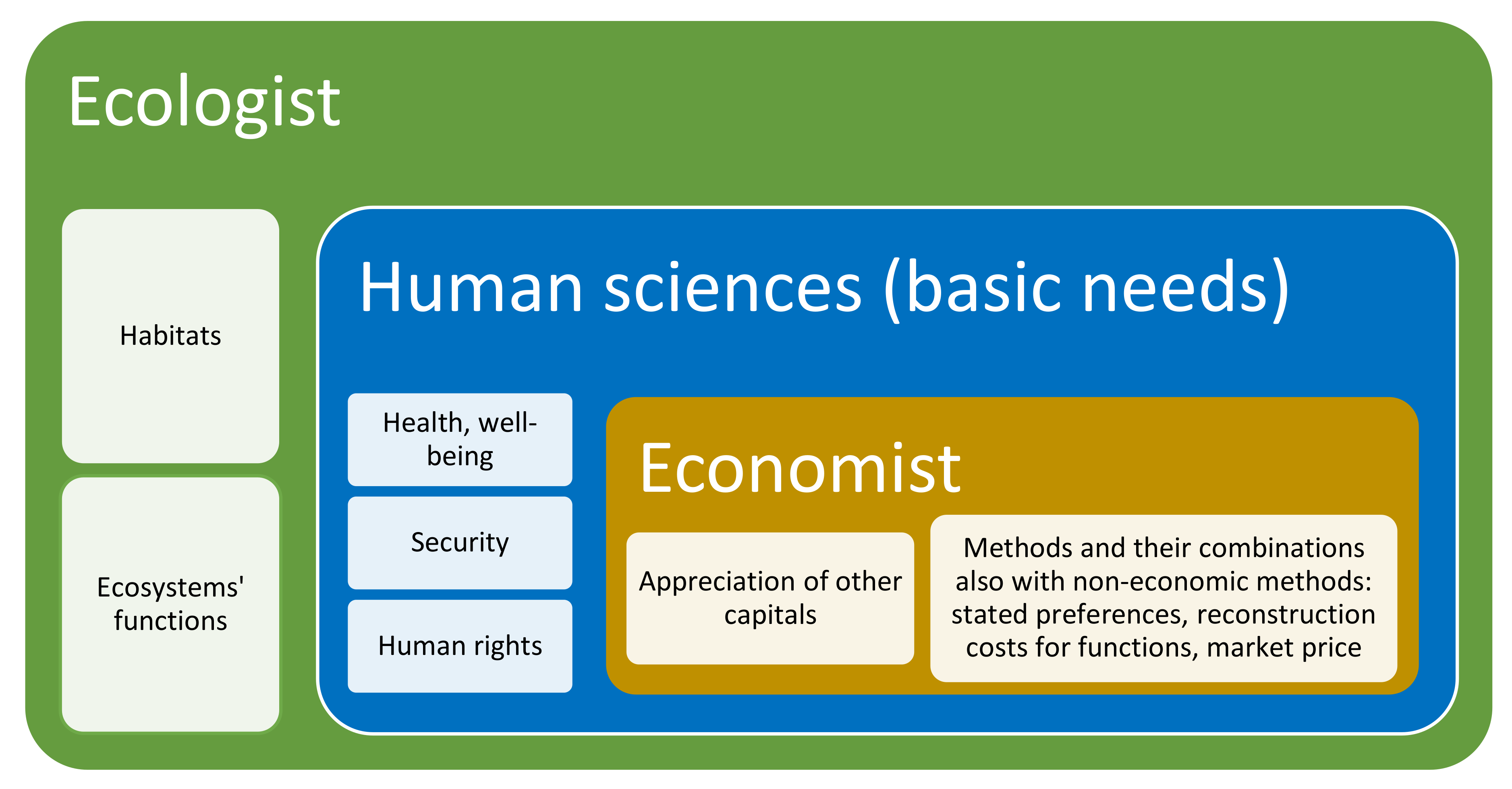
Natural: ecologists and representatives of ecosystems, communicating knowledge on ecosystem functions and requirements for their sustainable use.
Human: representatives of workers, entrepreneurs or civil society, focused on meeting human needs. Under this group, it would be very useful to involve, anthropologists, and health and well-being researchers, who were not present in the SimLab event.
Social: decision-makers, administrators and rulers, representing and interpreting societal aims.
Economic: economists, translating knowledge on human needs and ecosystems for individual or collective decision-making purposes.
On the basis of this feedback, the geoportal was updated and further developed; the current version of the participatory toolkit, which is presented in the previous sections, already reflects some of the suggestions made during this SimLab event.
The SimLab was applied to three cases: building a harbour, or a wind park and the maintenance of biodiversity. The participatory exercise allowed participants to understand the gaps inherent in the current methods for appreciating natural resources and the benefits these deliver, and to propose possible combinations and/or integrations, in order to represent the dimensions involved.
3.2. Feedback of the MARES SimLab and Discussion
The version of the MARES toolkit presented for testing did allow, according to the participants, to perform more advanced analyses; however, the geoportal functionalities were sometimes considered as too complex, so that the geoportal has been updated and simplified.
The MARES expert meetings highlighted the need to find and communicate the links from ecosystem and habitats to ecosystem functions and, finally, to the ecosystem services benefiting human beings. The communication of the existing knowledge about these relationships would help to make the importance and relevance of habitats in providing specific services visible and concrete. The availability of this knowledge, in a form that is easy to access, would facilitate and promote its use in evidence-based planning and decision-making processes.
One of the key issues raised during the testing event dealt with the range of ecosystem services that could be selected as a target of the valuation. The range of ecosystem services was considered to be too wide, including both intermediate and final services. As stated by several experts, the valuation methods are suitable only for the valuation of final services. Moreover, when assessing ecosystem functions (intermediate services), a problem of double counting may arise. This view was to some extent challenged, claiming that the classification of environmental services adds unnecessary complexity to the exercise and hides the contribution of intermediate services in the production of final services.
A further suggestion was made on this topic, proposing that valuation methods could only connect to final environmental services, but while doing this, the expert would see the list of intermediate services contributing to that final service. Some economists claimed that economic valuation methods of final services and other non-economic methods (e.g., ecology-based) assessing intermediate functions are not commensurable and cannot be assessed by the same meta-evaluation framework.
According to this view economic valuation should complement the ecological assessment and be added on top of that. This would mean that once the ecosystem functions have been physically and ecologically assessed (Natural capital), and once human basic needs and well-being would have been assured (Human capital), then, valuation methods would allow in supporting choices on the side of societal aims (Social capital). However, even if this view is theoretically valid, this does not happen in practice. Valuation methods are sometimes used to support decision-making without applying suitable methods for estimating possible changes in other value dimensions. In this case, specific choices might jeopardize Natural or Human capital equilibrium. It is common that different assessments are not integrated in practice, nor do they take into account the respective outcomes. As an example, the communication of a price for a fish species does not include the total maximum amount that is possible to catch, without putting at risk the species itself.
Therefore, in order to provide a higher level of quality in the knowledge transfer, combinations of methods should be encouraged. The application of MARES geoportal could create a solid knowledge base for this task.
To give another example, as discussed in the earlier expert meeting, a more integrated approach could consider a reconstruction or maintenance cost, representing the Natural dimension, added to a price. The final cost would be equal to the market price (resulting from mechanisms of offer and demand, referring to Social capital), plus a quote which is required to pay back the Natural capital (maintaining/recovering habitat and ecosystem functions). Sometimes the habitat might not be recoverable, and it would be important to think which method would be worth to apply in order to make unrecoverable impacts emerging. Could, in that case, the cost increase exponentially? The MARES toolkit in this way can practically implement the conceptual vision of the economic valuation as complementary to the ecological one.
In this way, data or data sources on the intermediate services would be made available, and this would strengthen the understanding about the linkages between ecosystems, ecosystem functions and the services that actually bring benefits to human beings.
Feedback on the functionalities of the participatory toolkit was also given, i.e., a suggestion to add a field for ‘multi-dimensional method’, which cannot be included ed under any of the existing categories, has been taken into account in the current version of the geoportal.
4. Conclusions and Further Developments
Intensification and diversification of human-induced pressures in marine ecosystems have raised concerns about several sustainability-diminishing consequences. Recent scientific evidence unambiguously points to innovative and sustainable ideas in order to help the ocean economy transformation towards a greener future. To date, such blue economies are poorly performing in European seas and this situation is due to the lack of and/or a scattered nature of basic background knowledge to guide sustainable governance and decision making.
The geospatial representation of the knowledge on marine habitats and ecosystem services enables effective and powerful communication to decision-making and society at large. These approaches have been applied at a local scale, for example, in the context of Mapping Ocean Wealth, a project developed by The Nature Conservancy [
24]. This project aims to spatially present the value of ecosystem services created by marine and coastal ecosystems at the local level. Through this work, the project has developed maps illustrating both the habitat coverage and the intensities of ecosystem service created by the habitat [
25]. Burdon et al. [
26] have developed similar regional maps through a process of participatory mapping in the UK. However, based on our knowledge, the concept of MARES geoportal that synthesizes existing ecological knowledge across the Baltic Sea and brings it together with participatory expert elicitation on valuation methodologies is rather unique and has not been tested before. Obviously, mapping ecosystem services and related habitats at a larger scale involves several challenges. Ecological processes are complex and the chains linking habitats to functions and in turn to services are mostly not (totally) known [
27,
28]. Some ecosystems produce services jointly [
29], making it difficult to distinguish the share of each specific ecosystem that contributes to generating the service. Also, some ecosystem services are more visible than others and therefore more suitable to spatial representation, especially at local or sub-regional scale. Implementing a similar mapping in the Baltic Sea context would require considerably more resources.
There is a need for operational approaches that integrate various sources of data and knowledge into easy-to-use analytical tools for management and decision-making advice. Such tools are currently being developed for Maritime Spatial Planning (MSP). In fact, the adoption of an ecosystem-based MSP has aimed to develop planning solutions that would maintain existing and emerging human uses, reduce use-conflicts, and most importantly sustain ecosystem health and services for future generations. Similarly, in the Baltic Sea region, several different kinds of platforms containing geospatial data already exist.
The MARES toolkit adds important elements to operationalise ecosystem services in support of ecosystem-based MSP. Therefore, in order to better use recognised and well-established data sources, it would be advisable to develop interfaces to connect and integrate the MARES geospatial toolkit with other suitable and well-known web-portals. For example, HELCOM, a governing body of the Helsinki Convention, maintains a Map and Data Service, providing a multitude of geospatial data sets relevant for policy-making at the Baltic Sea level [
30]. The European Marine Observation and Data Network (EMODnet) is another long-term initiative that collects and presents European marine data from various organizations through the European Atlas of the Seas portal [
31] Moreover, many national-level initiatives collecting and sharing marine spatial data also exist.
The Marine Spatial Planning in the Baltic Sea is largely based upon the geospatial representation of nature values and human uses, in the form of large databases represented by multi-objective applications. These tools guide the ecosystem-based allocation of human activities at sea and assist decision-makers in achieving environmental and socio-economic sustainability. However, the information flow is mostly unidirectional, as users mostly view and analyse the existing spatial data. In order to increase evidence base, we first need to systematically collect and harmonize a critical amount of environmental data and then use this knowledge to support a process of social learning and improve the efficiencies of economic and non-economic valuation methods. In general, ecological systems are complex and the only practical way to synthesize the current knowledge of ecosystems and their values and to address cumulative anthropogenic impacts on the target ecosystems is to follow a systematic quantitative literature review approach. Then this plethora of information should be communicated to other scientific disciplines and shared among different stakeholders so that the valuable knowledge about ecosystems and ecosystem functions could be capitalized when evaluating ecosystem services and the benefits these provide to humankind. The variety of valuation methods aims to concretize the evidence about the nature and significance of these benefits, to ensure that they are not neglected in decision-making, in pursuit of the SDGs. In order to turn this vision into practice, the MARES participatory geospatial toolkit combines approaches to collect information from academic (systematic review) and non-academic sources (expert feedback) and then all this evidence is synthesized and shared in an easy-to-use format. At this stage, users are able to consult the tool and provide various types of data and knowledge helping to bridge the divide between science, policy, and society. As such the tool forms a solid link between science, policy, and society as well as it enables communicating individual and collective decision making and support societal choices towards objectives of sustainable human development.
The MARES toolkit includes a participatory interface between science, policy, and society, which is not very common 21, yet very important and relevant for the mentioned purposes. The toolkit initiates a participatory process of social learning through a Delphi type of interactive consultation, allowing participants to interact and propose insights, to illustrate the linkages between habitats and ecosystem services, and in turn the benefits for human well-being. It facilitates the processes of co-creation of knowledge and a more informed and evidence-based decision making. The toolkit brings high levels of understanding of the dynamic interactions between different dimensions and of a holistic and integrated vision of systems’ sustainability. This integrated and trans-disciplinary perspective and the user-friendly translation of this integrated knowledge for the society are characteristics that cannot be easily found in earlier geospatial tools.
The MARES toolkit represents a starting point for a continuous, long-term process, collecting data from different parts of the Baltic Sea and providing a suitable basis for aggregating scientific knowledge on the services that specific ecosystems produce that can be further detailed and connected to the locations of the habitats. In this way, it forms an extensive and Baltic Sea-wide data set, based on academic knowledge, that can be used and further developed for decision-making.
In summary, the MARES toolkit first contributes to breaking the isolation between science communities and to developing more holistic and integrated approaches. For the science community, this means coming out from the laboratories, integrating results, and cooperating in a systemic approach with other disciplines.
Secondly, it summarises and communicates knowledge for the use of decision-makers as well as individual citizens, so that their informed choices would more easily reach SDGs or any other goals for their well-being and sustainable development. The provision of more objective evidence also reduces risks of social conflict, based on non-supported and subjective interests.
With further development, the MARES geoportal could act as an effective Decision Support Tool (DST). Pınarbaşı et al. [
32] reviewed 34 different DSTs used in the Marine Spatial Planning processes globally and identified key priorities for the development of future DSTs. They highlighted the need to develop multi-functional and integrated tools that can support planners to solve, in particular, economic and social issues related to the sustainable management of marine resources. Functions enabling participatory approaches and stakeholder consultations were also seen as important. Applying frequent testing and feedback cycles and user-oriented design for the development of the MARES geoportal could result in DST that can fill some of the gaps raised in the selection of DSTs currently in use.
In fact, in order to provide concrete support for the decision-making in the Baltic Sea, the development of the MARES geospatial toolkit should be developed collaboratively with potential users. Through the means of co-creation, the contents of the geoportal can be matched with the actual needs of those responsible for marine planning. In addition, the technical usability and easiness experienced by the users are crucial for the success of the geoportal: as noted by Stalzenmüller et al. 21, who reviewed different GIS-based tools used in the marine planning processes, many of the tools are technically complex and could only be used by scientists or programmers with GIS expertise. Stalzenmüller et al. 21 also highlighted the role of good-quality input data and the suitability of the data for the purposes of the analysis.
For all that has been exposed above, the MARES toolkit also has the potentiality to facilitate and promote funding to research based on science integration and interaction with policy and society. However, the toolkit developed is currently still a work-in-progress and requires further testing. In order to accomplish this aim, this first version of the MARES geoportal will continue to be developed and improved based on the suggestions made during this project and through continuous participation and improvement.
Moreover, one main current limitation of the toolkit is related to the lack of a huge amount of primary ecological data, even though the Baltic Sea is among the most studied seas worldwide. This involves higher uncertainty for decision-making purposes. In addition, ecological data are presented at a large spatial scale. This level of resolution may be too large for some aspects of coastal management which require knowledge on certain environmental conditions that varies greatly at very fine spatial scales. In order to attempt overcoming the described limitation, the geoportal is already being currently used as a basis for the development of the on-going MAREA project (From MARine Ecosystem Accounting to integrated governance for sustainable planning of marine and coastal areas), already funded by the Interreg Central Baltic Programme. The main characteristic of the planned approach is to focus the analysis on specific pilot cases so that the toolkit will be tailored for By involving a broad range of experts, stakeholders and actors in the Baltic Sea region, the intention of the new MAREA project is to use the participatory meta-evaluation to assess a much larger number of indicators, relevant to the pursuit of the SDGs. This will be done through an ecosystem perspective, by taking into consideration the relationships between the performance of socio-economic activities and human well-being together with the environmental status and ecosystem functioning. The final aim is to provide a geospatial and participatory system of metrics that can support individual and collective choices in pursuit of sustainable development.


