Abstract
The constantly growing number of motor vehicles increases the biodiversity conservation awareness of the public. To this end, numerous compensation measures are implemented, primarily provision of wildlife crossing infrastructure to guide animals over and under transport routes. There are different design aspects that must be considered in the case of wildlife crossings located in rural areas and in forests. An interdisciplinary approach should be employed for the wildlife crossing design, involving specialists from different fields of science. This article deals with the effect of local landscape elements and structures on the acoustic environment on the wildlife overpasses located in rural areas. Several tests were carried out, covering the levels of traffic, improvements around the existing overpasses and the noise distribution on them. For the final analysis, seven overpasses were chosen, differing in terms of the landscape elements and structures present. Five of them included noise barriers of different shapes and lengths and had a flat approach area. Two crossings did not have noise barriers and the approach areas were located in varied terrain. The analysis of the derived sound maps allowed for the determination of the effect of the different landscape elements and structures on the noise distribution on the overpasses under analysis. Earthen berms aligned with the noise barriers and extending to the length defined by the approach area topography were found to be the most effective noise-reducing measure.
1. Introduction
The need to make the transport of people and goods faster, more comfortable and safer triggers expansion of the expressway and railroad networks. This, in turn, leads to permanent fragmentation of natural habitats into ever smaller isolated patches, affecting the freedom of movement of wild animals, with the transport routes functioning as virtually impassable barriers. Larger species, including roe deer (Capreolus capreolus), red deer (Cervus elaphus) and wild boar (Sus scrofa) migrate during specific seasons of the year, mainly in search of food and to reproduce, covering in this way considerable distances. Along a road running for a few hundred kilometres, either existing or under construction, we can expect to find up to a few thousand wild animals, depending on environmental conditions [1,2]. This biological variability can be affected by a road having a barrier effect on their existence and leading to fragmentation of habitats.
In Western Europe, the problem of decreasing wildlife populations was recognised by environmentalists already in the 1970s [1,2,3] and geneticists undertook thorough studies on different animal species [3,4,5], which led to establishing a relation between the decreasing numbers of wild animals and landscape fragmentation [6,7]. Following examinations of the well-developed road and rail networks and fragmented habitats, they proposed compensation measures with the primary role played by wildlife crossings [1,3]. The first crossing structures to reconnect fragmented habitats were built in the 1970s and 1980s [3]. These structures were narrow and poorly suited to the needs of wildlife migration. In the 1990s, effectiveness surveys were carried out for the existing crossing infrastructure, which led to developing the principles of design of crossing structures reconnecting fragmented habitats (further called wildlife crossings), recognition of the need to consider the needs of specific species and identification of poor merging of the structures with the surrounding landscape [3]. Moreover, the crossing structures were subdivided into overpasses (green or landscape bridges) and underpasses. A more comprehensive approach to the problems of environmental protection, biodiversity conservation and compensation measures was gradually applied in Western Europe at the end of 20th century and in the beginning of 21st century [1,8,9,10], tying environmental, construction and economic problems with the resultant functionality of the constructed crossing. The study published in reference [11] describes an innovative method used in applied ecology and conservation biology, while the authors of reference [12] refer to the purpose of conservation and management and to the sensitivity to habitat fragmentation in central Italy. At that time, the first guidelines for the construction of wildlife crossings were also developed in Poland [9,13]. The greatest developments in the research on sustainable integration of environment and road networks were observed in the last twenty years, in line with the recommendations of the European Council and the conclusions of the EU Environment Council stated in 2010 and in 2011, which included the development of two strategies [14,15]:
- target for 2020—to halt the loss of biodiversity, as far as practicable, while stepping up actions to prevent biodiversity loss,
- vision for 2050—the protection and restoration of the natural environment because of its substantial value and to avoid catastrophic changes caused by the loss of precious biological values.
Taking into account the above statements, the Conference of European Directors of Roads (CEDR) during its meeting in Copenhagen in 2011 [14] chose COST 341 [1] as the primary interdisciplinary manual to be used for the identification of conflicts and for developing eco-friendly solutions pertaining to broadly understood sustainable integration of the road network and the natural environment. Furthermore, the content of the manual was to be regularly updated, supplemented and expanded with new environmental issues. The current knowledge on the impact of roads on biodiversity is much greater than it was several years ago. Based on the literature review and analysis of the conclusions of the CEDR, we can state that an interdisciplinary approach should be applied in the road network design process, involving land planners, road and bridge engineers, environmentalists, landscape architects and economists.
Section 2 defines the hearing ranges of wild animals typically found in rural areas and describes the assumptions used in the development of acoustic maps in order to find the landscape elements and structures that are the most relevant to the distribution of noise. Section 3 presents the obtained noise maps of the selected green bridges with characteristic features. Section 4 provides a short discussion of the obtained research results. The results of the comparison of the noise maps are presented in Section 5.
2. Materials and Methods
2.1. Adopted Subdivision into Zones of the Overpass Area and Its Surroundings
For better definitions of construction and environmental issues pertaining to the design of wildlife overpasses, their area has been divided into three zones [16,17,18,19] called “approach”, “entrance” and “deck” areas. In some guidelines [19,20,21], the approach area is called “surrounding area” and an additional term “buffer zone” was introduced by reference [22]. Conversely, in the Polish guidelines [23] and in the article [24] concerning the establishment and maintenance of roadside vegetation, the approach and entrance areas are jointly called the “attraction zone” and the “exclusion fence area” is sectioned off, in addition.
Figure 1 represents the adopted division of a wildlife overpass into the respective areas, based on the analysis of the guidelines [16,19,20], distinguishing the deck, approach and entrance areas. Figure 1b includes the exclusion fence area, an additional zone introduced in the Polish guidelines [23], and the roadside vegetation area on the slopes of the road cutting and bridge abutments, which was distinguished in reference [24].
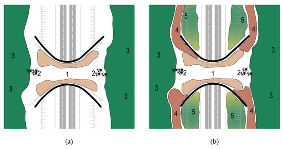
Figure 1.
Wildlife overpass areas: (a) according to the intended use, based on references [16,19,20]; (b) according to the proposals [23,24]. Designations: 1—deck area, 2—entrance area, 3—approach area, 4—exclusion fence area, 5—roadside vegetation on the slopes of the road cutting and bridge abutments.
2.2. Sustainable Principles of Design
The review of the literature (Section 1) reveals a lack of studies in which an interdisciplinary approach was applied, which, besides giving the land planners the principles of design of individual crossing structures, taking account of the need to ensure continuity of landscapes and habitats, would also discuss the aspects of sustainable development of the wildlife crossing areas to enhance wildlife movements and extend the knowledge on the spreading of noise, exhaust fumes and pollution around these structures. The available studies concern primarily ecological issues (i.e., factors ensuring the continuity of landscapes and biotopes) [1,2,3]; construction, structural and economic aspects [17,19,20,21]; selection of plant species [16,20] and the results of studies on the width and openness of the crossing structures conducted in France [25], Switzerland [26], the USA [27,28,29], and Sweden [30].
Taking this into account, and in accordance with the provisions of reference [14], this article supplements this interdisciplinary approach with the knowledge of the acoustic environment on wildlife overpasses. It analyses the issues related to the features provided around the crossing structure and their effect on the acoustic environment and relates these issues to the principles of sustainable design. According to these principles, sometimes referred to also by a more communicative and attractive name of “green architecture”, there are a few fundamental principles distinguished in the design process [31,32,33], namely, conservation of energy, use of alternative sources of energy, the three R’s (reduce, reuse, recycle) and respect for the user and land. In relation to the design of wildlife crossings reconnecting fragmented habitats, these principles require the provision of effective isolation, i.e., particular care in the selection of the crossing location so that it lies on the existing migration routes, and isolation of the crossing space from the nearby human settlements. These issues are developed in detail in article [22]. The principle of sustainable design relating to the use of alternative sources of energy is applied mainly in architecture and in general construction. In the case of wildlife crossings, this mainly concerns care for the natural environment, i.e., use of appropriate natural landscape elements and structures, including native vegetation naturally growing around the crossing, as well as wooden screens, boulders and standing or uprooted tree stumps [33,34]. In sustainable design of wildlife crossings, particular attention is paid to small ponds in the vicinity, which are natural watering places for wild animals. Similar recommendations of sustainable design of wildlife crossings can be applied to the three R’s (reduce, reuse, recycle). This concept embraces a large group of recommended actions that should lead to frugal use of land, smaller volumes of structures and the use of standardised structural systems enabling shorter times of closure of the migration route during construction of the crossing structure. The last principle of sustainable design relates to the care for the user and land, i.e., its frugal use and merging of the crossing structure with the landscape as far as practicable. The proposed schematic of the primary principles of sustainable design of wildlife overpasses is represented in Figure 2.
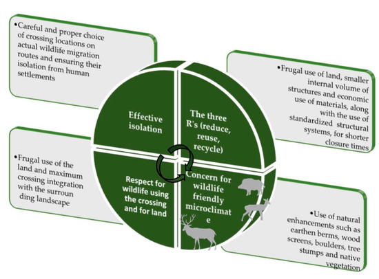
Figure 2.
Proposed diagram of the basic procedure in the sustainable design process [33,34].
One of the issues that combines the three principles of sustainable design (the three R’s, respect for the user and land and ensuring of microclimate friendly to animals) is the provision of landscape elements and structures intended to improve the acoustic environment. It is an issue of primary importance, yet very difficult to study and analyse. The effect of noise on wild animals was investigated by many researchers and these problems are described, for example, in references [35,36,37]. Focusing on the most common species of wild animals, the authors studied the effects of road noise on the hearing ranges of roe deer (Capreolus capreolus) [38,39] and red deer (Cervus elaphus) [40,41] and the distances of individual noise ranges from the road [42,43]. However, the results of the studies were related more to the determination of the sensitivity of wild animals to road noise and selection of appropriate deterrent devices during the time when a given location was passed by a car [44,45,46]. The author of this article expanded these issues by linking the landscape elements and structures present on the overpass and in its surroundings with the road traffic noise distribution pattern in the crossing area [34,47,48]. The results of the associated research and the obtained noise maps were published in references [33,49]. The factors relevant to the noise distribution patterns on wildlife overpasses include the location of the road in relation to the surrounding land, features located on the slopes in the immediate vicinity of the crossing structure, length and type of the noise barrier and the arrangement and height of earthen berms constructed by the crossing [33,34,49]. Considering the diversity of issues and a lack of uniformity in the provision of landscape elements and structures on different wildlife overpasses, this article deals with the acoustic environment on wildlife overpasses located in rural areas. The characteristic features of such overpasses include open swaths of land and a lack of tight natural flanking features that would absorb road noise.
2.3. Assumptions for Acoustic Map Development
Taking into account the high cost of construction of wildlife overpasses, it is indispensable to analyse their expected effectiveness, i.e., acceptance by wild animals. If a given crossing satisfies the location requirements defined by the need and the monitoring results, has appropriate width and has correct construction, there is one last element to ensure the effectiveness of the crossing and its acceptance by wildlife: landscape elements and structures located on and around the crossing, taking due account of the vegetation types in the vicinity, in accordance with the recommendations of reference [1]. However, it is difficult to judge, based on the preliminary assumptions regarding the landscape elements and structures present with the area of the crossing, if it will be finally accepted by the wild animals for which it is intended. The proposed acoustic environment, determined with the use of the Traffic Noise [50] software, can be one of the possible determinants of acceptance of a given crossing by animals. The factors relevant to this environment (Figure 3) include the topography of the surrounding land (biotic, abiotic and hydrographic conditions); location of overpass; volume of traffic; percentage of HGV’s; type, length and height of the installed noise barriers; spatial arrangement of earthen berms and their parameters; width of the crossing structure and the associated landscape elements and structures.
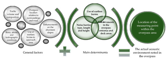
Figure 3.
Schematic for considering various factors that may have a bearing on the acoustic environment on the crossing under analysis [33].
The parameters of the provided noise barriers (i.e., their type, length and height), arrangement of the earthen berms and supplementary vegetation influence, as well as the humidity of air in the passageway, degree of air pollution and blinding of animals by headlights, all affect overpass usage. Considering the above facts, we can put forward a hypothesis that by reducing noise due to the provision of the landscape elements and structures on the approach to and within the passageway, we can indirectly also improve the air humidity, reduce air pollution and protect animals from blinding with headlights, in this way enhancing wildlife movements. Working on this hypothesis, the author analysed the distribution of noise and the obtained noise maps of selected green bridges located in rural areas, differing in terms of landscape elements and structures located in the crossing area and its immediate vicinity.
2.4. Hearing Range of Wild Animals
The analyses of noise maps of wildlife overpasses take account of the hearing range of wild animals. In most cases, in rural areas, the species in consideration include roe deer (Capreolus capreolus), fallow deer (Dama dama), hedgehogs (Erinaceus), hares (Lepus) and sometimes also red deer (Cervus elaphus) and wild boar (Sus scrofa). From among these animals, roe deer (Capreolus capreolus) and fallow deer (Dama dama) are the primary users of the wildlife overpasses located in rural areas. Taking this into consideration, the hearing ranges of roe deer (Capreolus capreolus), given in various publications, were analysed [39,40,41]. The main studies, presented in [44,45,46], concerned the reaction of animals to various sounds emitted by the deterrents mounted on the road or on the vehicles. The publications [38,39] stated that deer (Capreolus) had the greatest hearing sensitivity between 1 and 8 kHz, with a peak sensitivity at 4 kHz and a range from 0.5 to 12 kHz (at 85 dB(A)). According to a similar study, white-tailed deer (Capreolus) were able to hear in the range of 0.25 to 30 kHz, with a peak sensitivity between 4 and 8 kHz [38,46]. Therefore, based on these studies we can conclude that deer (Capreolus) have a hearing range similar to that of humans, i.e., 20 Hz to 20 kHz. Considering the above, and taking note that the noise maps and their relationships with the landscape elements and structures present will be analysed by people, in this article the noise levels are given in dB(A) i.e., in the human hearing range. This makes the noise distribution evaluation in the wildlife crossing area more clear and understandable to the people analysing it.
2.5. Methods of Analysing Noise Maps and the Basic Assumptions of the Study
From the preliminary noise distribution studies carried out by the author on over a dozen overpasses located in rural areas, differing in terms of landscape elements and structures present in their vicinity [28,29], it was concluded that a comparison of the resultant noise maps was problematic because the obtained distribution of noise depended, firstly, on the actual parameters of traffic on the road under analysis and, secondly, on factors such as the topography of the surrounding land, overpass location, biotic and abiotic conditions and on many other factors related directly to the local landscape elements and structures (Figure 3). Taking the above into consideration, when developing the noise map, the author followed the basic principle in use and divided the area under study into hexagonal fields. As a result, 320–400 of the fields were obtained and noise data were assessed for each of them separately. The decision on the actual number of the hexagonal fields into which to divide the area was taken at the map development stage. A similar approach was described in reference [51], when analysing annoyance to people caused by traffic noise in built-up areas. However, one of the most important principles of the comparative assessment of noise maps is to ensure homogeneity of the factors under analysis, which also has an effect on the level of noise but play a secondary role in a given case. A similar method of noise distribution modelling with spatial variability through the use of homogeneous prediction regions was described in reference [52].
In order to determine which landscape elements will create an acoustic environment and movement conditions friendly to wild animals, the author chose seven different structures for study. Next, she assumed hypothetically for all the cases under analysis the same traffic volume, the same percentage of HGV’s, the same vertical alignment of the road in relation to the adjacent land and the same design parameters of the road (i.e., the same number of traffic lanes and width of the median). On five structures, noise barriers were actually present and in these cases they were assumed to be of equal height and different shapes and lengths, to reflect the actual situation. On two structures, instead of proper noise barriers, there were small earthen berms and this situation was taken into account in the comparison of the structures. Moreover, the author assumed identical topography of land, i.e., flat terrain, location of the road in a road cutting and varying vertical alignment, the same in all the cases under analysis. Only for two structures without noise barriers, natural topography was assumed on both sides of the road, which entailed additional comparative analyses. This assumption of unified main factors, i.e., homogenous prediction regions, affecting the distribution of noise enabled obtaining and comparing noise maps in terms of the landscape elements and structures provided around and within the crossing structure and the length of the noise barrier and its routing, as well as the arrangement of earthen berms or small natural mounds.
Moreover, taking this into account and to ensure uniformity of the various factors relevant to the noise distributions, all the analyses related to the development of the noise maps assumed the same season of the year, temperature and humidity of the air. Furthermore, considering that wild animals living in rural areas may use the crossing structures both during the day and overnight, the noise maps were developed for the same traffic volumes: 1500 veh/h, 20% of which were HGVs, during evening hours and 500 vehicles/h, 15% of which were HGVs, during the morning hours. In order to obtain comparable traffic volumes and percentages of HGVs, the author carried out 24-h surveys on a few selected motorways in Poland and in Germany over a few business days during summer. Considering that wild animals tend to move around mostly between 6 p.m. and midnight and between 6 a.m. and 9 a.m., as suggested in reference [53], the author adopted average values from the 24-h traffic surveys, limited to the above-mentioned evening and morning hours.
Since noise distribution varies in the vertical plane in relation to the surrounding land, it became necessary to choose a representative height, both for the purpose of developing the noise maps and for check-up noise measurements in the vicinity of overpasses. The typical noise measurement height is 4 m above the ground. However, this height is appropriate to the impact of road traffic in built-up areas [54,55]. Considering the specific nature of the analysed wildlife overpasses and the subject of assessment, namely the impact of road noise on wild animals, this article assumes that all the noise maps and measurements will be made for the height of 1 m above the ground level, i.e., the deer’s (Capreolus) ear height.
2.6. Description of the Geometrical Parameters of the Structures Selected for This Study
The crossing structures selected for the noise environment study had different design, namely, three were rectangular and four parabolic-shaped. In all the analysed cases, the road ran in a road cutting and the crossing was constructed at the level of the surrounding area. The comparative analyses assumed that five of them were provided with 3 m high wooden anti-glare screens of different lengths and deflection angles, according to the actual situation. The widths of structures, measured along the road median between the outer edges of the crossing structure, were more or less the same for all the structures under analysis. However, the crossing structures differed in terms of the actual width at the narrowest point, shape and length of the noise barriers, the design of the earthen berms, surrounding area and planted vegetation. The parameters of these structures and selected landscape elements and structures in their immediate vicinity are compiled in Table 1. The parameters of the bridges, earthen berms, noise barriers and other landscape elements and structures were measured using the procedures available in the Google Earth program [48] for topographic measurements (of lengths and elevations).

Table 1.
Parameters characterising the analysed wildlife overpasses and the local landscape elements and structures.
2.7. Description of the Surroundings and the Landscape Elements and Structures at the Overpasses Selected for This Study
Google Earth images [56] showing the landscape elements and structures in the immediate vicinity of the analysed overpasses are shown in Figure 4, Figure 5, Figure 6, Figure 7, Figure 8, Figure 9 and Figure 10. The landscape elements and structures present within and in the immediate vicinity of the compared wildlife overpasses vary considerably. On two square-shaped crossings, the existing landscape elements and structures in the deck area were considered, comprising shrubs of different species and heights and irregular natural mounds of up to 1 m in height (structure No. 1—Figure 4) and 1.5–2 m high earthen berms contiguous to the noise barriers. This was different in the case of structure No. 3 where earthen berms were up to 3 m high and ran along the crest of the road cutting slope, parallel to the road and contiguous to the noise barriers (Figure 6). The actually existing landscape elements and structures, comprising shrubs of different species and heights, were considered also for two parabolic-shaped bridges (structure No. 2—Figure 5 and structure No. 4—Figure 7). Additionally, on the two next bridges, designated No. 5 and No. 6, the existing landscape elements and structures were considered in the analysis. In the case of structure No. 5, these were double earthen berms, ca. 0.5 m high, running just above the bridge edge and the second earthen berm, up to 2 m high running along the top edge of fill (Figure 8). On bridge No. 6, it was a single, ca. 0.5 m high earthen berm running along the bridge edge on the top line of fill (Figure 9). The last of the analysed structures, designated No. 7, was distinguished by the very poor presence of landscape elements and structures, limited to grass cover, both on the slopes and in the deck area (Figure 10). In modelling the noise levels on wildlife overpasses located in rural areas, in order to enable comparative analysis of the landscape elements and structures present in the approach area, it was assumed that cereals grow to a maximum of 1 m high. Conversely, for the slopes of road cuttings, the actual conditions noted at a given structure were considered, i.e., plantings- or grass-covered areas, as can be seen on the satellite images of the analysed structures (Figure 4, Figure 5, Figure 6, Figure 7, Figure 8, Figure 9 and Figure 10). Four crossing structures were built before 2000, two in France (Figure 5 and Figure 7) and two in Germany (Figure 8 and Figure 9). The next two structures, located in Germany, were built around 2002 (Figure 4) and around 2007 (Figure 6). The last of the analysed crossings was built in Poland in 2009 (Figure 10).
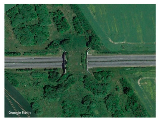
Figure 4.
Wildlife overpass No. 1. [56] (53°33′46.38″ N, 13°29′49.57″ E, A20 near the village of Kublank, Germany).
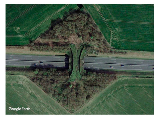
Figure 5.
Wildlife overpass No. 2. [56] (50°13′53.38″ N, 1°45′7.32″ E, A16 near the village of Forest-Montiers, France).
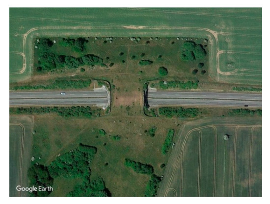
Figure 6.
Wildlife overpass No. 3. [56] (54°9′5.32″ N, 13°10′5.11″ E, B96 near the village of Bremerhagen, Germany).
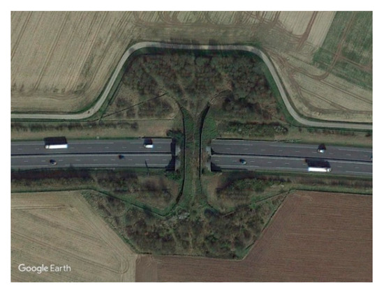
Figure 7.
Wildlife overpass No. 4. [56] (50°15′31.52″ N, 1°44′50.32″ E, A16 near the village of Forest-Montiers, France).
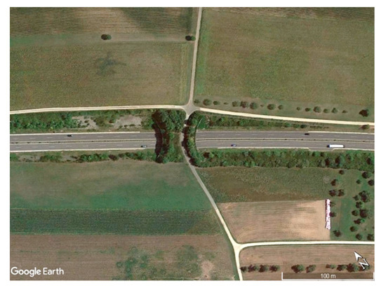
Figure 8.
Wildlife overpass No. 5. [56] (47°45′0.67″ N, 9° 0′20.32″ E, B33 near the village of Markelfingen, Germany).
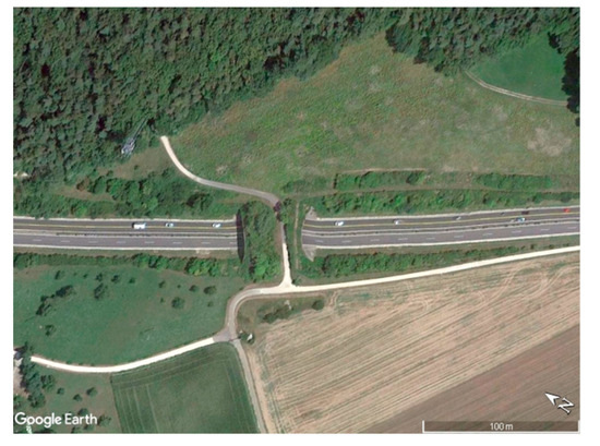
Figure 9.
Wildlife overpass No. 6. [56] (47°44′18.90″ N, 9°1′8.57″ E, B33 near the village of Markelfingen, Germany).
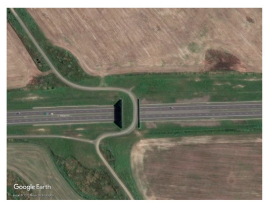
Figure 10.
Wildlife overpass No. 7. [56] (53°4′2.46″ N, 14°51′42.74″ E, S3 near the village of Krzemlin, Poland).
3. Analysis of the Noise Distribution on Wildlife Overpasses during the Day and Overnight
The analysis of the noise environment on the analysed bridge No. 1 (Figure 11) showed that both noise barriers with a loggia over the median strip and irregular earthen berms constructed near the ends of the noise barriers and in the deck area effectively reduce the noise level. The noise levels in the approach and deck areas did not exceed 65 dB(A) (Figure 11a) in the evening and 55 dB(A) in the morning (Figure 11b). When these data are, for comparison purposes, related to the standard requirements applied in Poland [57], we can state that the noise levels during the evening hours in both the approach and deck areas are comparable to the admissible value for single-family housing areas during the day and night for a 16-h measurement period and are by 10 dB(A) lower in the morning. Lower noise levels on the structure and in its vicinity in the morning mean more favourable passage conditions for animals. Lower pollution levels can also be expected owing to the installed noise barriers, earthen berms and vegetation planted on the road cutting slopes and on the abutments.
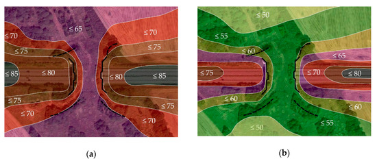
Figure 11.
Noise map of the crossing structure No. 1 plotted on a Google Earth satellite image [56]: (a) in the evening; (b) in the morning. Additional markings used on the map: solid line designates the centre line of the noise barriers and broken line designates the centreline of earthen berms. The noise levels are given in dB(A).
The factors contributing to reduction of the road noise include noise barriers, earthen berms and groves located on the surface of the crossing structure. In addition, the numerous landscape elements provided on the road cutting slopes, namely the vegetation of different species and heights, especially near the abutments, is a factor highly relevant to noise reduction. The level of noise was further reduced by the symmetrically arranged recesses in both barriers (Figure 12), which considerably disturb the propagation of sound waves at the point of the highest accumulation, i.e., over the median [33,34]. This is a sensitive point where the road noise combines with the sound reverberated under the structure. Compared to the other noise maps of the subsequent wildlife overpasses, lowering of road noise on bridge No. 1 can be attributed, most probably, to a large extent to the plantings present on the road cutting slopes and to a large, irregular shape landscaped area with a rich vegetation cover (Figure 13 and Table 1).
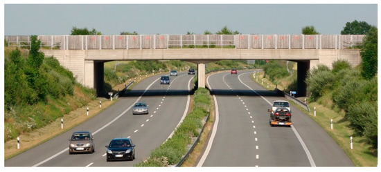
Figure 12.
Central recess in a wooden noise barrier located over the median strip.
Figure 13.
Plantings of different species and heights provided on the road cutting slopes.
The analysis of the noise environment on the narrow overpass No. 2 (Figure 14) showed that the considerable reduction of the noise level in the deck area can be attributed to parabolic noise barriers and rich vegetation cover on the road cutting slopes, composed of various species and varying in height. Similarly to the bridge No. 1, the noise levels varied up to 60 dB(A) in the evening (Figure 14a) and did not exceed 55 dB(A) in the morning (Figure 14b). In this case, the symmetrically arranged vegetation on a diamond-shaped landscaped area surrounding the structure had probably a considerable, as compared to the other structures, effect on noise reduction (the average length of landscaped area on the road cutting slopes on either side of the crossing was ca. 70 m at ca. 70 m depth of landscaped area inward the approach area, measuring from the road cutting slope crest).
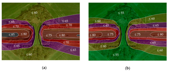
Figure 14.
Noise map of the crossing structure No. 2 plotted on a Google Earth satellite image [56]: (a) in the evening; (b) in the morning. The additional designations are the same as in Figure 11. Noise levels are given in dB(A).
In this case, the symmetric landscape area in the immediate vicinity of the structure and its shape—as well as symmetric, short earthen berms on both sides—also had a bearing on the reduction of noise in the immediate vicinity of the crossing structure. The structure was built of ca. 30 m long circular shells of corrugated sheet and the effective passage width at the narrowest point was ca. 9 m. Layered construction, with the top layer of corrugated sheet, followed by constructed fill also considerably contributes to effective disruption of sound waves and reduction of noise at the point of peak accumulation, i.e., over the median. Comparing the noise maps of bridges No. 1 and No. 2 (Figure 11 and Figure 14), we can conclude that, despite shorter earthen berms and a smaller landscaped area on bridge No. 2, a similar noise distribution was obtained along the approach, entrance and deck areas at a smaller overall cost (including the cost of design, construction and landscaping). Similarly, after comparing the noise maps of overpasses No. 2 and No. 4 that have twin structures and different shape of the landscaped area, we can state that on the former one the conditions are friendlier to animals thanks to the earthen berms and much larger and differently shaped landscaped area around the structure.
The analysis of the noise environment on the overpass No. 3 (Figure 15) showed that horseshoe-shaped noise barriers and 3 m high earthen berms constructed as their extension were also effective in reducing the level of noise in the deck area, despite poor landscaping with plants. However, the noise levels were higher, reaching up to 60 dB(A) in the evening (Figure 15a) and up to 55 dB(A) in the morning (Figure 15b). In comparison to the previously analysed overpasses, the crossing structure No. 3 is distinguished by very poor landscaping in the vicinity. Taking account of the cost of vegetation one should consider earthen berms provided as an extension of noise barriers, which can be constructed conveniently from the excavation spoil, as an equally effective noise reduction measure. The surfaces of earthen berms will, over time, become covered with vegetation, which will further contribute to noise reduction. Landscaping of the slopes and earthen berms after opening the road to traffic are presented in Figure 16. Comparing the noise maps of bridges No. 1, No. 2 and No. 3 (Figure 11, Figure 14 and Figure 15) we see that, owing to the earthen berms and landscaping of the road cutting slopes, a satisfactory distribution of noise was obtained along the approach, entrance and deck areas at a much lower cost of the landscaping work.
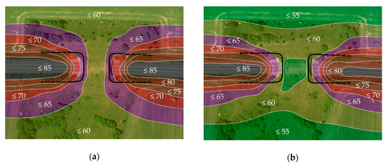
Figure 15.
Noise map of the crossing structure No. 3 plotted on a Google Earth satellite image [56]: (a) in the evening; (b) in the morning. The additional designations are the same as in Figure 11. Noise levels are given in dB(A).
Figure 16.
Plantings of different species and heights provided on the road cutting slopes and on the earthen berm contiguous to the noise barrier.
The analysis of the noise environment on the narrow overpass No. 4 (Figure 17) showed that extended noise barriers and rich vegetation in the trapezoid-shaped landscaped area decrease the level of noise solely in the deck area. The noise levels were the highest in this case, reaching up to 70 dB(A) in the evening (Figure 17a) and up to 65 dB(A) in the morning (Figure 17b). In comparison to the previously analysed bridges, these measures turned out to be less effective in terms of noise reduction, resulting in the acoustic environment less favourable to animals. That said, these measures can still effectively enhance wildlife movement in the morning, with the obtained reduction of noise to 65 dB(A) (Figure 17b) along the whole entrance and deck areas, and this at a much lower cost of landscaping works, as compared to the overpasses No. 1 and No. 2.
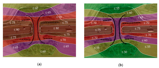
Figure 17.
Noise map of the crossing structure No. 4 plotted on a Google Earth satellite image [56]: (a) in the evening; (b) in the morning. The additional designations are the same as in Figure 11. Noise levels are given in dB(A).
Now let us move to the crossing structure No. 5 with two earthen berms where actual noise barriers were not provided. Comparing noise distributions on the overpasses No. 5 and No. 4 (Figure 18), we see similar noise distribution in the passage and entrance areas, despite a much lower cost of soft landscaping on the former. Differences in noise distributions were found in the approach area. Overpass No. 5 was chosen as particularly relevant to the subject of this research because, in addition to vegetation, the relief of the surrounding land has an effect on the distribution of noise. In the case of overpass No. 4, the relief is flat with only slight variations in elevation in the approach area. Conversely, at the overpass No. 5, the approach area slopes down away from the road, so that at the crest of the road cutting it is at the structure elevation, gradually sloping down away from the crossing structure. This proves that arable land in sloping areas can have the desired effect on the noise distribution in the approach area. The analysis of overpass No. 6 (Figure 19) supported this conclusion. It has very similar parameters to the overpass No. 5 and differences include only one earthen berm constructed on the bridge edge and an opposite inclination of land in the approach area, namely down towards the road. A higher elevation of land in the approach area, as compared to the deck area, results in a different distribution of noise around the structure and the road. Although the noise level in the morning hours did not exceed 65 dB(A), the shortest passage at that level of noise was noted only on the flat areas on both sides of the road, accompanied by rich landscaping around the structure (Figure 17) and where the land sloped down away from the road (Figure 18). With the land sloping down towards the road on both sides, the length of travel at the noise level of 65 dB(A) is much longer during the morning hours. These findings allow us to conclude that the landscaping design for the area around an overpass should consider not only earthen berms, noise barriers and improvements in the surrounding area but also the elevation of the adjacent land on both sides of the road.
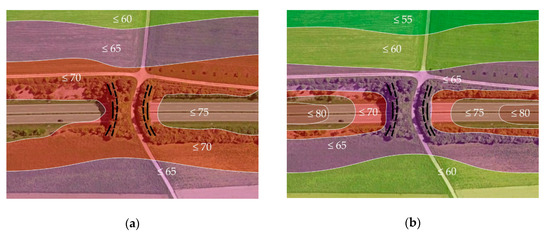
Figure 18.
Noise map of the crossing structure No. 5 plotted on a Google Earth satellite image [56]: (a) in the evening; (b) in the morning. The long-dashed line designates the earthen berm on the fill crest and short-dashed line designates the berm that determines the passage width. The noise levels are given in dB(A).
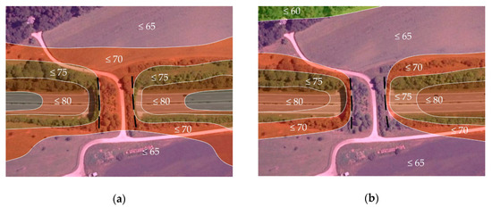
Figure 19.
Noise map of the crossing structure No. 6 plotted on a Google Earth satellite image [56]: (a) in the evening; (b) in the morning. The long-dashed line designates the earthen berm on the fill crest. The noise levels are given in dB(A).
In the analysis of the noise environment on the overpass No. 7 (Figure 20), it was found that the installed noise barriers decrease the noise level only slightly and only in the deck area. The levels of noise along the approach and entrance areas, at the deck area and on the slopes where landscaping was limited to grass cover were in this case much higher, reaching up to 75 dB(A) both in the evening (Figure 20a) and in the morning (Figure 20b). Landscaping limited to the grass cover on the slopes of the road cutting and on the land surface in the approach, entrance and deck areas does not ensure attractive conditions to animals and the structure can turn out to be ineffective, i.e., not accepted by animals. In this case, the land on both sides of the crossing is flat and the slopes of the 6-metre deep road cutting are vegetated solely by grass. The level of noise is high, both in the entrance and in the deck areas, which can discourage wild animals from using the crossing.
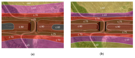
Figure 20.
Noise map of the crossing structure No. 7 plotted on a Google Earth satellite image [56]: (a) in the evening; (b) in the morning. The additional designations are the same as in Figure 11. Noise levels are given in dB(A).
4. Discussion
Taking account of the different landscape elements and structures located around wildlife crossings, we can conclude that in order to ensure wildlife-friendly acoustic climates, the wildlife overpasses planned in rural areas should be accompanied with vegetated areas, arranged symmetrically in relation to the road and to the crossing structure, such as used on the overpass No. 2 shown in Figure 5. This is a very costly improvement and additional cost related to future maintenance of vegetation must be taken into account. Moreover, the shrubs used for such landscaping must be tolerant to adverse conditions, including freezing temperatures, drought and pollution of air by vehicle exhaust fumes.
A much cheaper measure is using symmetric earthen berms (Figure 21), ca. 3 m high, running along the crest of the road cutting slopes over a minimum distance of 50 m as an extension of the installed noise barriers (overpass No. 3—Figure 6). A very important issue is a contiguous connection between the noise barrier and the earthen berms, as shown in Figure 16 and Figure 20. In addition to being a much less expensive option, this improvement reduces the level of noise in the approach, entrance and deck areas, thus, ensuring a wildlife-friendly acoustic environment on the route between the disconnected habitats. In addition, earthen berms are a quite effective barrier to the traffic-related pollution and exhaust fumes and play a role in ensuring appropriate humidity of the air, thus, contributing to a wildlife-friendly microclimate.
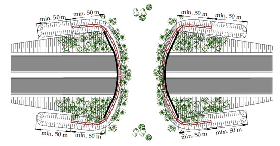
Figure 21.
Recommended landscaping for wildlife overpasses located in flat and open rural areas.
The surfaces of earthen berms can be left bare to become overgrown with natural vegetation over time or planted with shrubs tolerant to frost, drought and road pollution (Figure 22). Shrub species that grow naturally in the vicinity are preferred. The recommended species for open rural areas without natural groves include violet willow (Salix daphnoides), common elder (Sambucus nigra) and spindle tree (Euonymus macropterus) [33,34]. These species are relatively resistant to frost, drought and exhaust fumes. Inside the crossing structure, before the earthen berms, a few different species can be planted in addition, such as guelder rose (Viburnum opulus), blackthorn (Prunus spinosa), rowan (Sorbus aucuparia), alpine currant (Ribes alpinum), bramble (Rubus fruticosus) and red raspberry (Rubus idaeus) [33]. The deck areas of wildlife overpasses should be overgrown with grass and herbs, in most cases (Figure 23).
Figure 22.
Example of a green bridge featuring concrete noise barriers hidden behind earthen berms densely overgrown with shrubs, which extend the natural habitat area.
Figure 23.
Example of a green bridge located in an open rural area, featuring wooden noise barriers, supplemented by irregular mound-shaped earthen berms and fenced groves comprising the following shrub species: common broom (Cytisus scoparius), hazel (Corylus) and alpine currant (Ribes alpinum).
Attention is drawn to a few shrubs planted in the middle of the crossing entrance area (Figure 21) which will develop over time, becoming a characteristic feature for wildlife, signalling the presence of natural groves on their movement route between the habitats. In addition, an artificial pond can be provided in the approach area, intended to be used by animals as a watering hole, this in line with the recommendations given in references [3,19,25]. The noise distribution analyses and vegetation maintenance surveys spanning many years demonstrate the importance of carefully considered landscaping of the road cutting slopes near the abutments on the side facing the road and earthen berms running along the road cutting crest with shrubs of top tolerance to pollution from exhaust fumes. The effect of earthen berms is clearly visible in the distribution of noise on the bridge No. 3 (Figure 15). Similar noise distributions have been obtained, for example, on the overpass structures No. 1 and No. 2 (Figure 11 and Figure 14), yet in this case at a much higher cost of landscaping work and subsequent maintenance of vegetation.
In the case of rural areas featuring a varied topography in the approach area, parabolic-shaped noise barriers should be used, continued by contiguous earthen berms of the same height (Figure 24, Figure 25 and Figure 26). On the basis of the noise analyses represented in Figure 17 and Figure 18, we can conclude that in uneven terrain parabolic-shaped noise barriers should be used, supplemented with contiguous earthen berms of the same height. The lengths of such earthen berms depend on the direction in which the terrain slopes in the approach area. Depending on the local conditions, earthen berms should be at least 50 m wide (Figure 24), deflected outwards of the crossing in a parabolic curve (Figure 25 and Figure 26a). If such a long berm is not practicable due to the local conditions, a shorter berm can be constructed, as long as the slopes of the road cutting, abutment and earthen berm are generously landscaped. When a shorter earthen berm is provided, it is suggested to plant a large sea-buckthorn (Hippophae rhamnoides) grove before the berm, on the side facing the passageway. The sea-buckthorn shrubs within a few years develop into a thick grove, providing a very effective barrier to the propagation of noise and exhaust fumes [27,28]. The sea-buckthorn shrubs are frost, drought and road pollution tolerant. Additionally, the sharp thorns effectively discourage people from entering the deck area. Both types of landscape elements and structures provided in the immediate vicinity of the green bridge encourage wildlife movements. On the green bridges represented in Figure 24 and Figure 25 roe deer (Capreolus capreolus), fallow deer (Dama dama), hares (Lepus) and hedgehogs (Erinaceus) were often observed.
Figure 24.
Example of a green bridge located in a rural area, featuring parabolic noise barriers extended by contiguous earthen berms.
Figure 25.
Example of a contiguous, tight connection between the noise barrier and earthen berms.
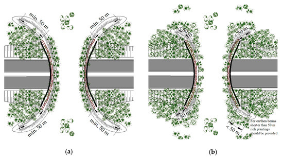
Figure 26.
Landscape elements and structures recommended for a wildlife overpass located in an uneven, open rural area: (a) example of landscape elements and structures recommended for over 50 m long berms; (b) example of landscape elements and structures recommended for up to 50 m long berms.
5. Conclusions
The above analyses allow the author to derive the following conclusions.
In open, flat rural areas, devoid of larger forest lands, symmetric, horseshoe barriers are recommended for wildlife overpasses, extending to 50 m beyond the edge of the structure and accompanied with contiguous earthen berms, also at least 50 m long and equal in height with the noise barriers.
In turn, in uneven areas with varied topography in the approach to the crossing, parabolic-shaped noise barriers may turn out to be effective if they are accompanied with contiguous earthen berms of the length appropriate to the local topography. Plantings should be appropriately selected, depending on the length of the provided earthen berms.
In open rural areas, the direction of inclination of terrain in the approach area has a significant effect on the obtained acoustic environment. The higher the approach area in relation to the passageway, the greater the noise level and appropriate additional measures should be implemented to obtain the required noise reduction. These measures can include larger vegetated areas, wider earthen berms planted with appropriate shrubs and tight contiguous connections between the noise barriers and earthen berms, which should be equal in height to the barriers.
In rural areas, wildlife overpasses that are provided solely with noise barriers ending at the abutment do not sufficiently enhance wildlife movement. Such crossings may not be accepted by wildlife and, thus, prove to be ineffective.
Funding
This research received no external funding.
Acknowledgments
The author wishes to thank the anonymous reviewers for their comments and suggestions which have helped to improve the manuscript.
Conflicts of Interest
The author declares that there is no conflict of interest.
References and Note
- Iuell, B.; Bekker, I.L.; Cuperus, R.; Dufek, J.; Fry, G.; Hicks, C.; Hlavá, V.; Keller, V.; Rosell, C.; Sangwine, T.; et al. COST 341: Habitat Fragmentation due to Transportation Infrastructure. Wildlife and Traffic: A European Handbook for Identifying Conflicts and Designing Solutions. In European Co-Operation in the Field of Scientific and Technical Research; KNNV Publishers: Delft, The Netherlands, 2003. [Google Scholar]
- Curzydło, J. Habitat Fragmentation by Motorways—A Real Threat to Animals Living in the Wild in Poland. Autostrady Mag. 2003, 6, 60–66. [Google Scholar]
- Carsignol, J. CETE de l’Est: Les Savoirs les Savoirs—Faire au Niveau des Projets, Les Connaissances Acquises en Matière de Conception et de Gestion des Passages Pour la Faune; Guides disponibles au SETRA: Lyon, France, 2008. [Google Scholar]
- Curzydło, J.; Konopka, J. Habitats Fragmented by Transport Infrastructure, Next Reconnected by Green Bridges and Culverts: Examples of Wildlife Crossing Structures in Austria, Belgium, France, Germany, Switzerland and Poland. In Proceedings of the International Scientific Technical Conference “Influence of Transport. Infrastructure on Nature”, Poznań, Poland, 13–15 September 2006; pp. 219–226. [Google Scholar]
- Bekker, H.; Iuell, B. Habitat Fragmentation Due to Infrastructure. In Proceedings of the International Conference on Ecology & Transportation “Making Connections” ICOET, Lake Placid, NY, USA, 24–29 August 2003; North Carolina State University: Raleigh, NC, USA, 2003; pp. 1–14. [Google Scholar]
- Battisti, C.; Amori, G.; De Felici, S.; Luiselli, L.; Zapparoli, M. Mammal road-killing from a Mediterranean area in central Italy: Evidence from an atlas dataset. Rendiconti Lincei Scienze Fisiche e Naturali 2012, 23, 217–223. [Google Scholar] [CrossRef]
- Russo, L.F.; Barrientos, R.; Fabrizio, M.; Di Febbraro, M.; Loy, A. Prioritizing road-kill mitigation areas: A spatially explicit national-scale model for an elusive carnivore. Wiley Divers. Distrib. 2020, 26, 1093–1103. [Google Scholar] [CrossRef]
- Bissonette, J.A. Evaluation of the Use and Effectiveness of Wildlife Crossing, Project No. NCHRP 25-27 FY04; Final Report; National Cooperative Highway Research Program Transportation Research Board of the National Academies: Salt Lake City, UT, USA, 2007. [Google Scholar]
- Jędrzejewski, W.; Nowak, S.; Kurek, R.; Mysłajek, R.W.; Stachura, K.; Zawadzka, B. Animals and Roads; Mammal Research Institute by PAN: Białowieża, Poland, 2004. [Google Scholar]
- Bennet, A.F. Linkages in the Landscape, The Role of Corridors and Connectivity in Wildlife Conservation; International Union for Conservation of Nature and Natural IUCN: Amsterdam, The Netherlands, 1999. [Google Scholar]
- Battisti, C.; Gianluca, P.; Giuliano, F. An Introduction to Disturbance Ecology A Road Map for Wildlife Management and Conservation; Springer: Berlin, Germany, 2016. [Google Scholar]
- Spinozzi, F.; Battisti, C.; Bologna, M.A. Habitat fragmentation sensitivity in mammals: A target selection for landscape planning comparing two different approaches (bibliographic review and expert based). Rendiconti Lincei, Scienze Fisiche e Naturali 2012, 23, 365–373. [Google Scholar] [CrossRef]
- GDDKiA. Catalogue of Road Environmental Protection Systems; (Appendix to GDDKiA’s ordinance No. 58 dated 19 April 2002); GDDKiA: Warsaw, Poland, 2002. [Google Scholar]
- Lund Ujvári, M.; Nilsson, L.; Rösten, E. Mobility for humans and wildlife—Cost-effective ways forward, Report on cost-effective mobility for humans and wildlife. In Conference of European Directors of Roads CEDR; Danish Road Agency: Copenhagen, Denmark, 2011. [Google Scholar]
- EU Biodiversity Policy Development-Environment. Available online: http://ec.europa.eu/environment/nature/biodiversity/policy/index_en.htm (accessed on 10 August 2019).
- Ministry of Agriculture, Food and the Environment. Documents for the Mitigation of Habitat Fragmentation Caused by Transport Infrastructure: Technical Prescriptions for Wildlife Crossing and Fence Design, 2nd ed.; Ministry of Agriculture, Food and the Environment: Madrid, Spain, 2016. [Google Scholar]
- National Cooperative Highway Research Program, Transportation Research Board—The National Academies. NCHRP Synthesis 305, Interaction between Roadways and Wildlife Ecology: A Synthesis of Highway Practice; National Cooperative Highway Research Program, Transportation Research Board—The National Academies: Washington, DC, USA, 2002. [Google Scholar]
- Seiler, A. The Toll of the Automobile: Wildlife and Roads in Sweden. Ph.D. Thesis, Department of Conservation Biology, Swedish University of Agricultural Sciences Uppsala, Upsala, Sweden, 2003. [Google Scholar]
- DEEL III, MJPO Leidraad Faunavoorzieningen bij Infrastructuur. Werkversie, De Vormgeving van Faunapassages; DEEL III, MJPO Leidraad Faunavoorzieningen bij Infrastructuur: Brussel, Belgium, 2011. [Google Scholar]
- Central Federal Lands Highway Division. Wildlife Crossing Structures Handbook, Design and Evaluation in North America; Central Federal Lands Highway Division: Lakewood, CO, USA, 2011. [Google Scholar]
- Queensland Government. Technical Publications: Fauna Sensitive Road Design; Queensland Government: Brisbane, Australia, 2011. [Google Scholar]
- Van der Grift, E.A.; Dirksen, J.; Ottoburg, F.G.W.A.; Pouwels, R. Recreatief Medegebruik van Ecoducten; Alterra Wangeningen UR, Alterra—Rapport 2097: Wageniungen, The Netherlands, 2010. [Google Scholar]
- GDDKiA. Guidelines for Establishment and Maintenance of Roadside Vegetation; (GDDKiA’s ordinance No. 10, dated 15.02.2013); GDDKiA: Warsaw, Poland, 2013. [Google Scholar]
- Furtak, M.; Mojecka, M. Design of Vegetation on Wildlife Crossings in the Context of Experiences and Regulations. Przestrzeń i Forma Mag. 2014, 22, 97–118. [Google Scholar]
- Carsignol, J. Fragmentation et Aménagements Spécifiques pour la Trame Verte et Bleue. Passage à Faune: Prise en Compte du Contexte Local, Conception, Efficacité; Guides disponibles au SETRA: Lyo, France, 2011. [Google Scholar]
- Trocmé, M. Habitat Fragmentation due to Linear Transportation Infrastructure: An overview of mitigation measures in Switzerland. In Proceedings of the 6th Swiss Transport Research Conference (STRC), Monte Verita/Ascona, Switzerland, 15–17 March 2006; pp. 1–20. [Google Scholar]
- Cramer, P. Determining Wildlife Use of Wildlife Crossing Structures under Different Scenarios; Utah Department of Transportation Research Division UDOT, Utah State University: Logan, UT, USA, 2012. [Google Scholar]
- Cramer, P.; The State of Wildlife Crossings in the West. Utah State University 28.09.2011, Connectivity Forum, Berkley 3.12.2012 CA. Available online: https://roadecology.ucdavis.edu/files/content/outreach/6_Cramer_ConnectivityForum_2012.pdf (accessed on 21 September 2020).
- Cramer, P. Wildlife Connectivity: Keeping Wildlife Moving and Alive, Mule deer Running over Utah’s Overpass I-15; Utah State University: Logan, UT, USA, 2009. [Google Scholar]
- Olsson, M.; Seiler, A. The use of a moose and roe deer permeability index to develop performance standards for conventional road Bridges. In Proceedings of the International Conference Safeguarding Ecological Functions Across Transport Infrastructure, IENE, Swedish Biodiversity Centre, Berlin, Germany, 21–24 October 2012. [Google Scholar]
- Vale, B.; Vale, R. Green Architecture: Design for an Energy-Conscious Future; Bulfinch Press: Boston, MA, USA, 1991. [Google Scholar]
- Wines, J. Green Architecture; Architecture & Design Series; Taschen America LLC: Los Angeles, CA, USA, 2000. [Google Scholar]
- Sołowczuk, A. Sustainable Design of Wildlife-Friendly Overpass Crossings; West Pomeranian University of Technology Szczecin—Publishing House: Szczecin, Poland, 2019; Available online: http://kdim.zut.edu.pl/fileadmin/pdf/Sustainable%20design%20of%20wildlife%20friendly%20overpass%20crossings.pdf (accessed on 21 September 2020).
- Sołowczuk, A. The Impact of Land Development on the Distribution of Road Noise Level; LAP LAMBERT Academic Publishing: Berlin, Germany, 2018. [Google Scholar]
- Bowles, A.E. Responses of Wildlife to Noise. In Book Wildlife and Recreationists: Coexistence through Management and Research; Knight, R.L., Gutzwiller, K.J., Eds.; Island Press: Washington, DC, USA, 1995; pp. 109–156. [Google Scholar]
- Prior, R. The Roe Deer: Conservation of a Native Species, 1st ed.; Swan Hill Press: Los Angeles, CA, USA, 1995. [Google Scholar]
- Centrum Nauki Kopernik. That’s Interesting, What Sounds do You Hear? Centrum Nauki Kopernik: Warsaw, Poland, 2015. [Google Scholar]
- Deer (Overview) Senses—Hearing. Available online: https://www.wildlifeonline.me.uk/animals/article/deer-overview-senses-hearing (accessed on 10 January 2020).
- D’Angelo, G.J.; De Chicchis, A.R.; Osborn, D.A.; Gallagher, G.R.; Warren, R.J.; Miller, K.V. Hearing Range of White-tailed Deer as Determined by Auditory Brainstem Response. J. Wildl. Manag. 2007, 71, 1238–1242. [Google Scholar] [CrossRef]
- Valitzski, S.A.; D’Angelo, G.J.; Gallagher, G.R.; Osborn, D.A.; Miller, K.V.; Warren, R.J. Deer Responses to Sounds from a Vehicle-mounted Sound-production system. J. Wildl. Manag. 2009, 73, 1072–1076. [Google Scholar] [CrossRef]
- D’Angelo, G.J.; van der Ree, R. Use of Reflectors and Auditory Deterrents to Prevent Wildlife-vehicle Collisions. In Handbook of Road Ecology; Wiley Blackwell: Chichester, UK, 2015; pp. 213–218. [Google Scholar] [CrossRef]
- Państwowe Wydawnictwo Rolnicze i Leśne. Animal Phisiology, a Handbook for Students of Veterinary Courses Run at Academies of Agriculture; Krzymowski, T., Ed.; Państwowe Wydawnictwo Rolnicze i Leśne: Warsaw, Poland, 1983. [Google Scholar]
- Schmidt-Nielsen, K. Animal Physiology: Adaptation and Environment; Państwowe Wydawnictwo Naukowe PWN: Warsaw, Poland, 2008. [Google Scholar]
- Scheifele, P.M.; Browning, D.; Collins-Scheifele, L.M. Analysis and Effectiveness of Deer Whistles for Motor Vehicles: Frequencies, Levels, and Animal Threshold Responses. Acoust. Res. Lett. 2003, 4, 71–76. [Google Scholar] [CrossRef]
- Noise Effects on Domestic Animals and Wildlife, Final EIS Volume II—Appendix E—Noise, Conference JPARC Modernization and Enhancement Environmental Impact Statement. In Wildlife and Recreationists: Coexistence through Management and Research; Joint Pacific Alaska Range: Anchorage, AK, USA, 2013; pp. E1–E64.
- Risenhoover, K.; Hunter, J.; Jacobson, R.; Stout, G. Hearing Sensitivity in White Tailed Deer; Texas A&M University Report; Department Wildlife and Fisheries Sciences: College Station, TX, USA, 1997. [Google Scholar]
- Sołowczuk, A. The effect of Improvements on the Distribution of Road Noise on the Surfaces of Wildlife Overpasses. In Proceedings of the 6th International Conference on Environmental Protection and Aesthetics in Transport Infrastructure, Kazimierz Dolny, Poland, 23–25 April 2014; Volume 13, issue No. 1. pp. 103–112. Available online: http://wbia.pollub.pl/files/85/attachment/vol13(1)/09.pdf (accessed on 21 September 2020).
- Sołowczuk, A.; Kacprzak, D. Ecological Recovery the Distribution of Road Noise Level Surface of the Upper Wildlife Crossings. In Proceedings of the Conference Web of Science, 16th International Multidisciplinary Scientific GeoConference SGEM 2016, Vienna, Austria, 2–5 November 2016; Green Design & Sustainable Architecture: Vienna, Austria; pp. 531–538. [Google Scholar] [CrossRef]
- Sołowczuk, A.; Kacprzak, D. Distribution of Noise Level on the Surface of the Upper Wildlife Overpasses Depend of Land Development. In Proceedings of the Conference Web of Science, 17th International Multidisciplinary Scientific GeoConference SGEM 2017, Albena, Bulgaria, 27 June–6 July 2017; Green Design & Sustainable Architecture: Albena, Bulgaria; pp. 563–570. [Google Scholar] [CrossRef]
- Program Traffic Noise, Poland, 2008.
- Paszkowski, W.; Sobiech, M. The Modeling of the Acoustic Condition of Urban Environment Using Noise Annoyance Assessmen. Environ. Model. Assess. 2019, 24, 319–330. [Google Scholar] [CrossRef]
- López-Quílez, A.; Muñoz, F. Geostatistical computing of acoustic maps in the presence of barriers. Math. Comput. Model. 2009, 50, 929–938. [Google Scholar] [CrossRef]
- Deer (Overview) Interaction with Humans—Vehicle Collisions. Available online: https://www.wildlifeonline.me.uk/animals/article/deer-overview-interaction-with-humans-vehicle-collisions (accessed on 10 November 2019).
- EKKOM Spółka z ograniczoną odpowiedzialnością. Guidelines for Noise Measurements by National Roads, carried out as part of the General Traffic Survey; GDDKiA: Warsaw, Poland, 2005; Available online: http://www.ek-kom.pl/kontakt/ (accessed on 21 September 2019).
- Kucharski, R.J.; Biniaś, K.; Danecki, R.; Grabowski, J.; Szymański, Z.; Taras, A. Guidelines for Drawing up Noise Maps, Updated Version; Chief Department of Environmental Protection: Warsaw, Poland, 2016. [Google Scholar]
- Google Earth. 2019. Available online: http://www.earth.google.com (accessed on 19 May 2019).
- Announcement of the Minister of Environmental Protection dated 15.10.2013 on the Maximum Allowable Levels of Noise in the Environment. Polish Official Journal of Laws, 22 January 2014; 112.
© 2020 by the author. Licensee MDPI, Basel, Switzerland. This article is an open access article distributed under the terms and conditions of the Creative Commons Attribution (CC BY) license (http://creativecommons.org/licenses/by/4.0/).