Puyango, Ecuador Petrified Forest, a Geological Heritage of the Cretaceous Albian-Middle, and Its Relevance for the Sustainable Development of Geotourism

 ,
, 
Abstract
1. Introduction
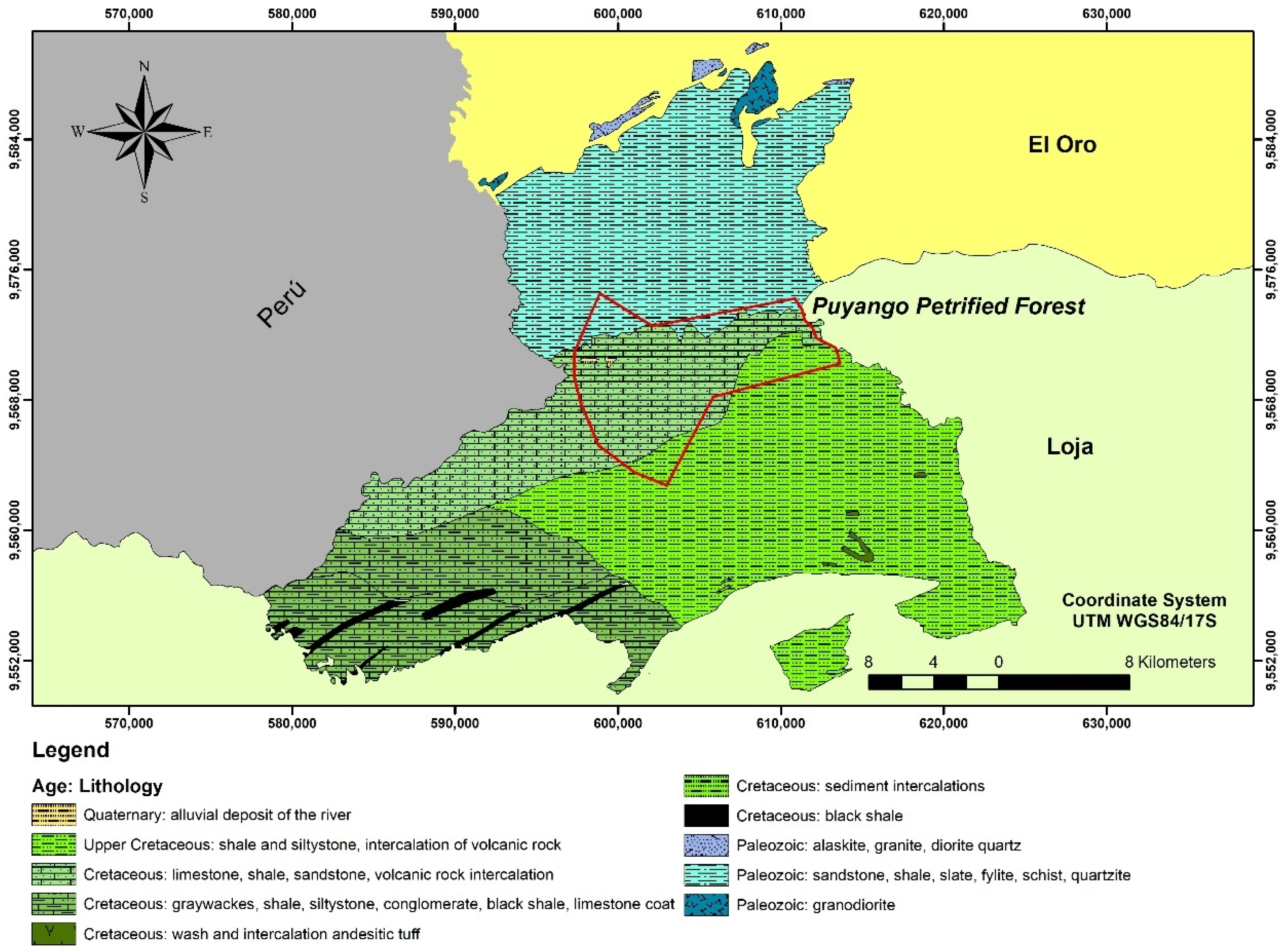
2. Overview of the Study Area
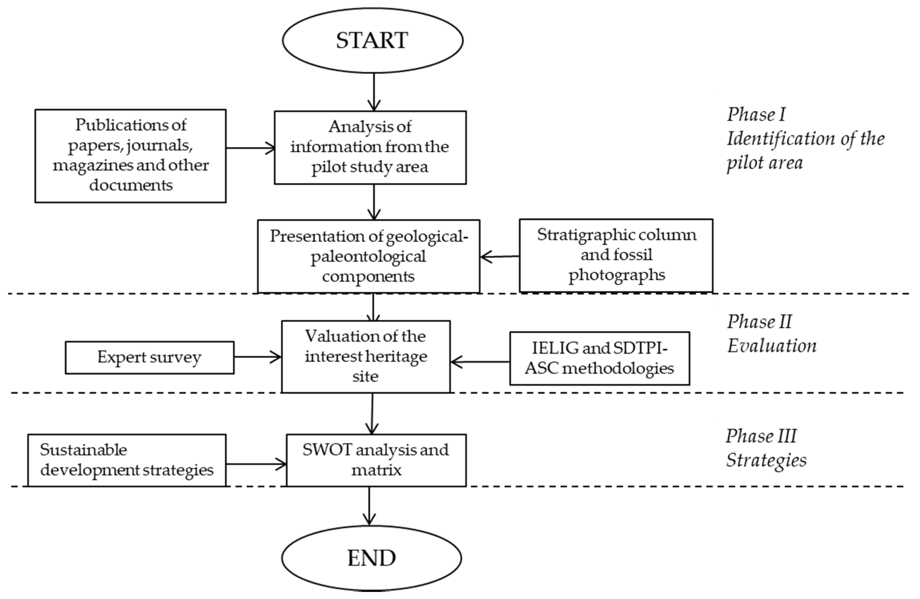
3. Materials and Methods
3.1. First Phase: Identification of the Pilot Area
3.2. Second Phase: Quantitative and Qualitative Evaluation
3.3. Third Phase: Strategies
4. Results
4.1. Identification of the Pilot Area
4.2. Evaluation
4.3. Strategies
5. Discussion
6. Conclusions
Supplementary Materials
Author Contributions
Funding
Acknowledgments
Conflicts of Interest
References
- Štrba, L.; Kolackovská, J.; Kudelas, D.; Kršák, B.; Sidor, C. Geoheritage and geotourism contribution to tourism development in protected areas of Slovakia-theoretical considerations. Sustainability 2020, 12, 2979. [Google Scholar] [CrossRef]
- Williams, M.A.; McHenry, M.T.; Boothroyd, A. Geoconservation and Geotourism: Challenges and Unifying Themes. Geoheritage 2020, 12, 1–14. [Google Scholar] [CrossRef]
- Lopes, R.F.; Candeiro, C.R.A.; de Valais, S. Geoconservation of the paleontological heritage of the geosite of dinosaur footprints (sauropods) in the locality of São Domingos, municipality of Itaguatins, state of Tocantins, Brazil. Environ. Earth Sci. 2019, 78. [Google Scholar] [CrossRef]
- Shekhar, S.; Kumar, P.; Chauhan, G.; Thakkar, M.G. Conservation and Sustainable Development of Geoheritage, Geopark, and Geotourism: A Case Study of Cenozoic Successions of Western Kutch, India. Geoheritage 2019, 11, 1475–1488. [Google Scholar] [CrossRef]
- Ferreira, A.R.R.; Lobo, H.A.S.; de Jesus Perinotto, J.A. Inventory and Quantification of Geosites in the State Tourist Park of Alto Ribeira (PETAR, São Paulo State, Brazil). Geoheritage 2019, 11, 783–792. [Google Scholar] [CrossRef]
- Dowling, R.K. Geotourism’s Global Growth. Geoheritage 2011, 3, 1–13. [Google Scholar] [CrossRef]
- Hurtado, H.; Dowling, R.; Sanders, D. An Exploratory Study to Develop a Geotourism Typology Model. Int. J. Tour. Res. 2006, 8. [Google Scholar] [CrossRef]
- Newsome, D.; Dowling, R. Geoheritage and geotourism. In Geoheritage: Assessment, Protection, and Management. Elsevier. Inc. 2018, 17, 305–321. [Google Scholar] [CrossRef]
- Dos Reis Polck, M.A.; de Medeiros, M.A.M.; deAraújo-Júnior, H.I. Geodiversity in Urban Cultural Spaces of Rio de Janeiro City: Revealing the Geoscientific Knowledge with Emphasis on the Fossil Content. Geoheritage 2020, 12. [Google Scholar] [CrossRef]
- Tavares, G.N.D.; Boggiani, P.C.; de Moraes Leme, J.; Trindade, R.I. The Inventory of the Geological and Paleontological Sites in the Area of the Aspirant Geopark Bodoquena-Pantanal in Brazil. Geoheritage 2020, 12. [Google Scholar] [CrossRef]
- Morales, J.; Azanza, B.; Gómez, E. El Patrimonio Paleontológico Español. Coloq. de Paleontol. 1999, 50, 53–62. (In Spanish) [Google Scholar]
- Gutiérrez, J. Determinación de la metodología límites aceptables de cambio como estrategia para el manejo del ecoturismo en el Bosque Petrificado Puyango. Third level. Bachelor’s Thesis, Machala Technical University, Machala, Ecuador, October 2015. (In Spanish). [Google Scholar]
- Meléndez, G. Definición y Valoración de la Geodiversidad, Análisis, Valoración y Protección Legal del Patrimonio Geológico y Paleontológico. Bachelor’s Thesis, Zaragoza University, Bilbao, Spain, 13 May 2010. [Google Scholar]
- Ordoñez, M.; Jiménez, N.; Suárez, J. Micropaleontología Ecuatoriana; Petroproducción, Guayaquil Geological Research Center, CIGG.: Guayaquil, Ecuador, 2006. (In Spanish) [Google Scholar]
- Ministerio del Ambiente del Ecuador. 2007. Plan Estratégico del Sistema Nacional de Áreas Protegidas del Ecuador 2007–201 (SNAP-GEF). REGLA-ECOLEX. Quito. Available online: http://maetransparente.ambiente.gob.ec/documentacion/WebAPs/PLAN%20ESTRATEGICO%20DEL%20SNAP.pdf (accessed on 14 December 2019).
- Yaguachi, B. Identificación y dinamización del Corredor de Endemismo Tumbesino, sector Bosque Petrificado de Puyango. Bachelor’s Thesis, Loja National University, Loja, Ecuador, 2012. (In Spanish). [Google Scholar]
- Instituto Espacial Ecuatoriano (IEE) y MAGAP (SINAGAP). Generación de Geoinformación Para la Gestión del Territorio a Nivel Nacional; Technical Memory (Geomorphology): Puyango Canton, Ecuador, 2013. (In Spanish) [Google Scholar]
- García, A.; Carcavilla, L. Documento Metodológico Para la Elaboración del Inventario Español de Lugares de Interés Geológico (IELIG); IGME Geological and Mining Heritage Research Area: Madrid, Spain, 2013. (In Spanish) [Google Scholar]
- Aguirre, Z.; Lopez, G. Conservations status of the dry forests of the province of Loja, Ecuador. Arnaldoa 2017, 24, 207–228. [Google Scholar] [CrossRef]
- Carrión, P.; Herrera, G.; Briones, J.; Caldevilla, P. Geotourism and Development Base on Geological and Mining Site Utilization, Zaruma-Portovelo, Ecuador. Geosciences 2018, 6, 205. [Google Scholar] [CrossRef]
- Jaramillo, J.; García, T.; Bolaños, M. Bosque Petrificado de Puyango y sus Alrededores: Inventario de Lugares de Interés Geológico; GEO Latitud, Publisher: Quito, Ecuador, 2017; Volume 1. (In Spanish) [Google Scholar]
- Gobierno Autónomo Descentralizado Municipal de Puyango. Plan de Desarrollo y Ordenamiento Territorial. 2014–2019. Available online: https://www.puyango.gov.ec. (accessed on 16 December 2019).
- Conservación de la Diversidad Biológica en Los Bosques Tropicales Bajo Régimen de Ordenación; UICN: Gland, Suiza y Cambridge, Reino Unido, 1992–1995; Volume Xii, p. 272. ISBN 2-8317-0251-8.
- Jiménez, H. Valoración de los servicios ecosistémicos de recreación y belleza escénica del Bosque Petrificado Puyango, 2015. Bachelor’s Thesis, Loja Private Technical University, Loja, Ecuador, 2017. (In Spanish). [Google Scholar]
- Puño, N. Environmental Management of the Puyango-Tumbes River Basin in Ecuador and Perú. Securing Water and Wastewater Systems: Global Experiences; Springer International Publishing: Cham, Switzerland, 2014; Volume 8, pp. 161–187. [Google Scholar] [CrossRef]
- Xomchuck, I.; Jimenez, N.; Valverde, F. PUYANGO: Entre pasado y presente. Estudio de Valoración del Bosque Petrificado de Puyango, Provincia de Loja, Ecuador, 1st ed.; ESPOL: Guayaquil, Ecuador, 2004; pp. 9–60. (In Spanish) [Google Scholar]
- Martz, J.W.; Parker, W.G. Revised lithostratigraphy of the Sonsela Member (Chinle Formation, Upper Triassic) in the southern part of Petrified Forest National Park, Arizona. PLoS ONE 2010, 5, e09329. [Google Scholar] [CrossRef] [PubMed]
- National Secretary of Planning and Development and National Information System, Information for planning and territorial planning, National Geographic Atlas. 2013. Available online: http://sni.gob.ec/atlas-geografico-nacional-2013. (accessed on 19 January 2020).
- Jiménez, N.; Ordóñez, M.; Suárez, J.; Tigreros, J. Estudio de Valoración y Diagnóstico de Paleontología, Botánica, Arqueología y Etnografía en los Cantones de Puyango, Celica y Paltas de la Provincia de Loja, 2001–2002, Paleontología y Micropaleontología del Bosque Petrificado de Puyango Provincia de Loja; Proyecto de Loja, Vol. 1; CEAA-ESPOL: Guayaquil, Ecuador, 2004. (In Spanish) [Google Scholar]
- Xomchuk, I.; Ramos, G.; Avilés, G. Estudio de Valoración y Diagnóstico de Paleontología, Botánica, Arqueología y Etnografía en los Cantones de Puyango, Celica y Paltas de la Provincia de Loja, 2001–2002, Valoración Socio-Etnográfica de los Cantones Puyango, Celica y Paltas; Proyecto de Loja, Vol. 2; CEAA-ESPOL: Guayaquil, Ecuador, 2004. (In Spanish) [Google Scholar]
- Zhunaula, V. Análisis de los Factores Potenciales que inciden en el hurto del patrimonio cultural en el Bosque Petrificado Puyango. Bachelor’s Thesis, Machala Technical University, Machala, Ecuador, 2016. (In Spanish). [Google Scholar]
- Cartuche, D.V.; Armijos, L.A.; Romero, C.S.; Ocampo, C.H. Evaluación del desarrollo turístico en el Bosque Petrificado de Puyango (BPP), sur de Ecuador. Rev. Espac. 2019, 40, 23. [Google Scholar]
- Calva-Nagua, D.X. El desafío de las Fuentes arqueológicas para la educación ecuatoriana. Maestros y Sociedad 2018, 15, 393–408. (In Spanish) [Google Scholar]
- Carrión-Mero, P.; Loor-Oporto, O.; Andrade-Ríos, H.; Herrera-Franco, G.; Morante-Carballo, F.; Jaya-Montalvo, M.; Aguilar-Aguilar, M.; Torres-Peña, K.; Berrezueta, E. Quantitative and Qualitative Assessment of the “El Sexmo” Tourist Gold Mine (Zaruma, Ecuador) as A Geosite and Mining Site. Resources 2020, 9, 28. [Google Scholar] [CrossRef]
- García, J.; Falaschi, P.; Zamuner, A. Fungal-arthropod-plant interactions from the Jurassic petrified forest Monumento Natural Bosques Petrificados, Patagonia, Argentina. Palaeogeogr. Palaeoclimatol. Palaeoecol. 2012, 329–330, 37–46. [Google Scholar] [CrossRef]
- Woodcock, D.; Meyer, H.; Dunbar, N.; Mclntosh, W. Geologic and taphonomic context of El Bosque Petrificado Piedra Chamana (Cajamarca, Peru). Geol. Soc. Am. Bull. 2009, 121, 1172. [Google Scholar] [CrossRef]
- Tarras-Wahlberg, N.H.; Flachier, A.; Lane, S.N.; Sangfors, O. Environmental impacts and metal exposure of aquatic ecosystems in rivers contaminated by small scale gold mining: The Puyango River basin, souther Ecuador. Sci. Total Environ. 2001, 278, 239–261. [Google Scholar] [CrossRef]
- Salazar, S. Propuesta de un Plan de comunicación para promocionar, localmente, al bosque petrificado Puyango, ubicado en las provincias ecuatorianas de El Oro y Loja, como una novedosa alternativa turística. Bachelor’s Thesis, Las Americas University, Quito, Ecuador, 2010. (In Spanish). [Google Scholar]
- Carcavilla. Geodiversidad y Patrimonio Geológico. Instituto Geológico y Minero de España; Edición Parques Nacionales: Madrid, Spanish, 2014; p. 21, NIPO: 474-11-012-3. (In Spanish) [Google Scholar]
- Gómez, J.; Magnin, L. Cartography of Geomorphological Units of the Bosques Petrificados de Jaramillo National Park (Santa Cruz Argentina) for its Geo-Archaeological Implementation. Inst. De Geogr. Unam 2019, 98. [Google Scholar] [CrossRef]
- Baranyi, V.; Reichgelt, T.; Olsen, P.E.; Parker, W.G.; Kurschner, W.M. Norian vegetation history and related environmental changes: New data from the Chinle Formation, Petrified Forest National Park (Arizona, SW USA). Bolletin Geol. Soc. Am. 2018, 130, 775–795. [Google Scholar] [CrossRef]
- Núñez, P.; Vejsbjerg, L. El Turismo, entre la actividad económica y el derecho social en El Parque Nacional Nahuel Huapi, Argentina, 1934–1955. Estud. Y Perspect. En. Tur. 2010, 19, 930–945. (In Spanish) [Google Scholar]
- Aragón, S.; Woodcock, D. Plant Community Structure and Conservation of a Northern Peru Sclerophullous Forest. Biotropica 2010, 42, 262. [Google Scholar] [CrossRef]
- Herrera-Franco, G.; Carrión-Mero, P.; Alvarado, N.; Morante-Carballo, F.; Maldonado, A.; Caldevilla, P.; Briones-Bitar, J.; Berrezueta, E. Geosites and Georesources to Foster Geotourism in Communities: Case Study of the Santa Elena Peninsula Geopark Project in Ecuador. Sustainability 2020, 12, 4484. [Google Scholar] [CrossRef]
- Štrba, Ľ.; Kršák, B.; Sidor, C. Some Comments to Geosite Assessment, Visitors, and Geotourism Sustainability. Sustainability 2018, 10, 2589. [Google Scholar] [CrossRef]


| IELIG Methodology | ||||||
|---|---|---|---|---|---|---|
| Scientific Weight (Sw), Didactic Weight (Dw), Tourist Weight (Tv), Fragility Weight (Fw) and Vulnerability due to Anthropogenic Threats Weight (Vw) | ||||||
| Indicators/Parameters | Punctuation | Weight | ||||
| Sw | Dw | Tw | Fw | Vw | ||
| Representativeness | 0–4 | 30 | 5 | |||
| Prototype location character | 10 | 5 | ||||
| Degree of scientific knowledge of the place | 15 | |||||
| State of conservation | 10 | 5 | ||||
| Observation conditions | 10 | 5 | 5 | |||
| Rarity | 15 | 5 | ||||
| Geological diversity | 10 | 10 | ||||
| Didactic content | 20 | |||||
| Logistics infrastructure | 15 | 5 | ||||
| Accessibility | 15 | 10 | ||||
| Association with other elements of the natural and/or cultural heritage | 5 | 5 | ||||
| Magnificence or beauty | 5 | 20 | ||||
| Population density (potential aggression) | 5 | 5 | 5 | |||
| Proximity to recreational areas (immediate potential demand) | 5 | 5 | ||||
| Informative content/Informative use detected | 15 | |||||
| Potential to carry out touristic and recreational activities | 5 | |||||
| Socioeconomic environment | 10 | |||||
| LIG size | 15 | 40 | ||||
| Vulnerability to plunder | 30 | |||||
| Natural threats | 30 | |||||
| Proximity to anthropic activities (infrastructure) | 20 | |||||
| Interest for mining | 15 | |||||
| Site protection regime | 15 | |||||
| Physical or indirect protection | 15 | |||||
| Accessibility (potential assault) | 15 | |||||
| Place ownership regime | 10 | |||||
| Total | 100 | 100 | 100 | 100 | 100 | |
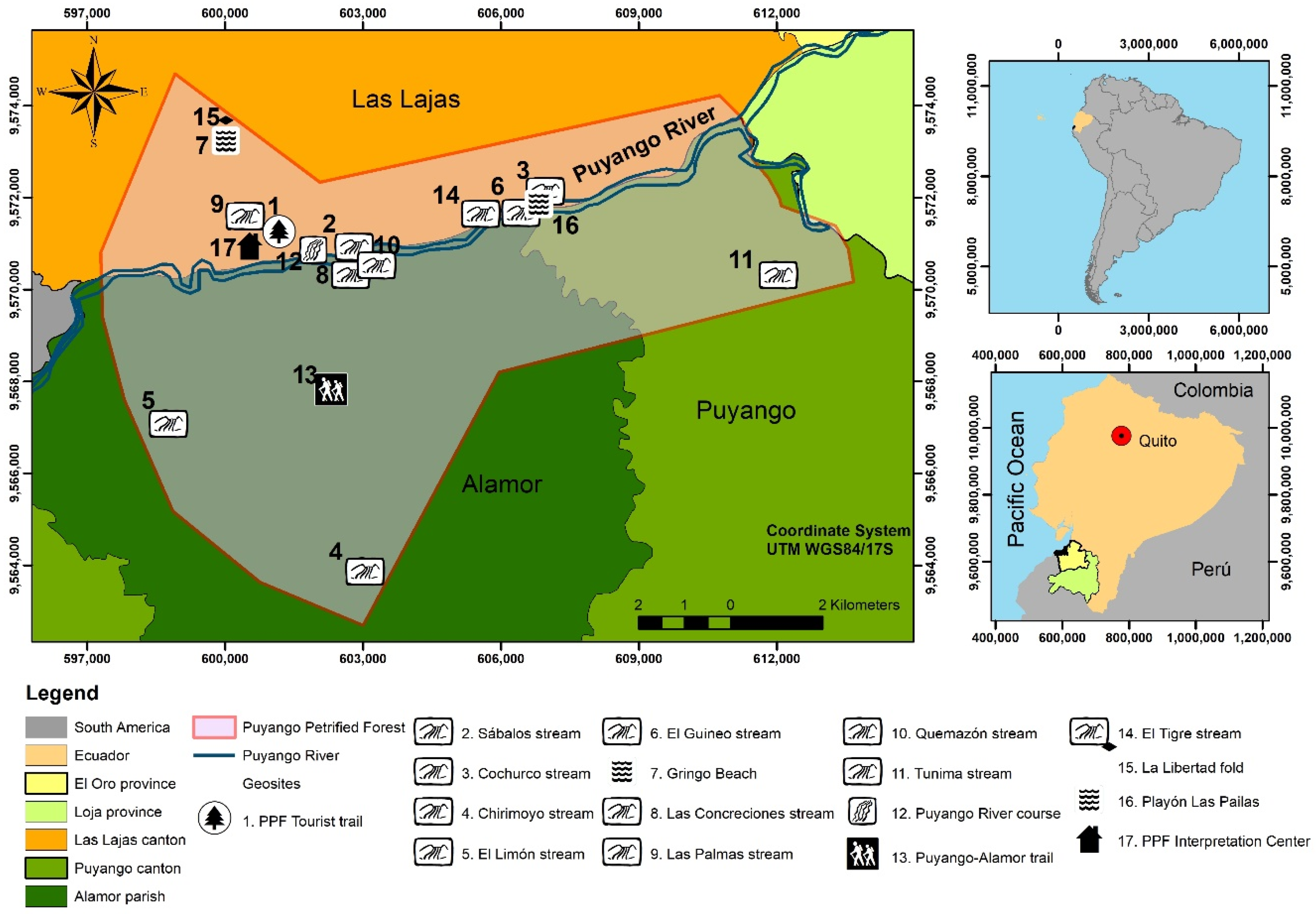
| N° | LIGs | Geological Aspects | Paleontological Aspects | Observations |
|---|---|---|---|---|
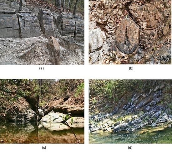
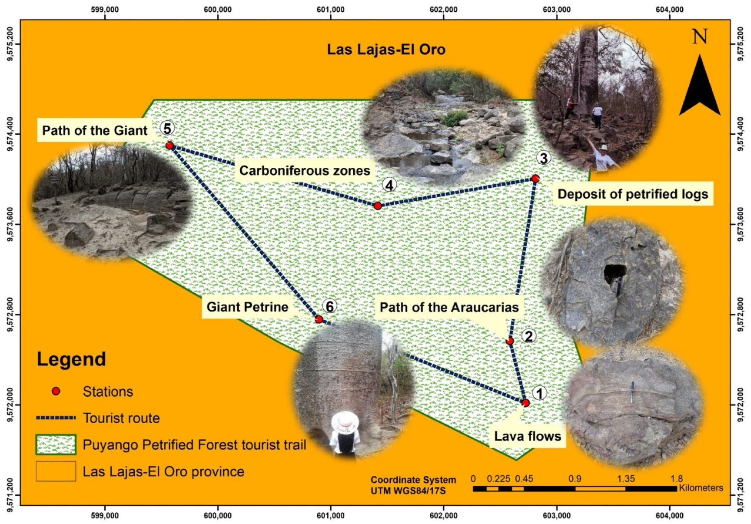
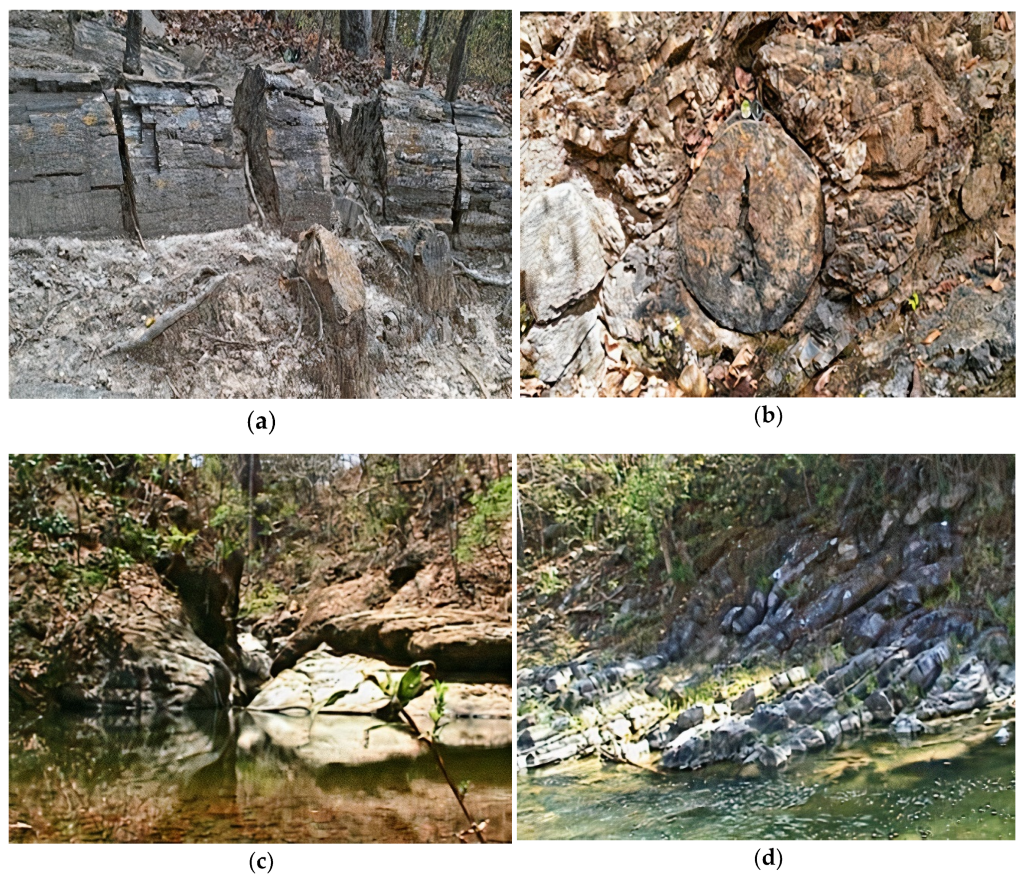
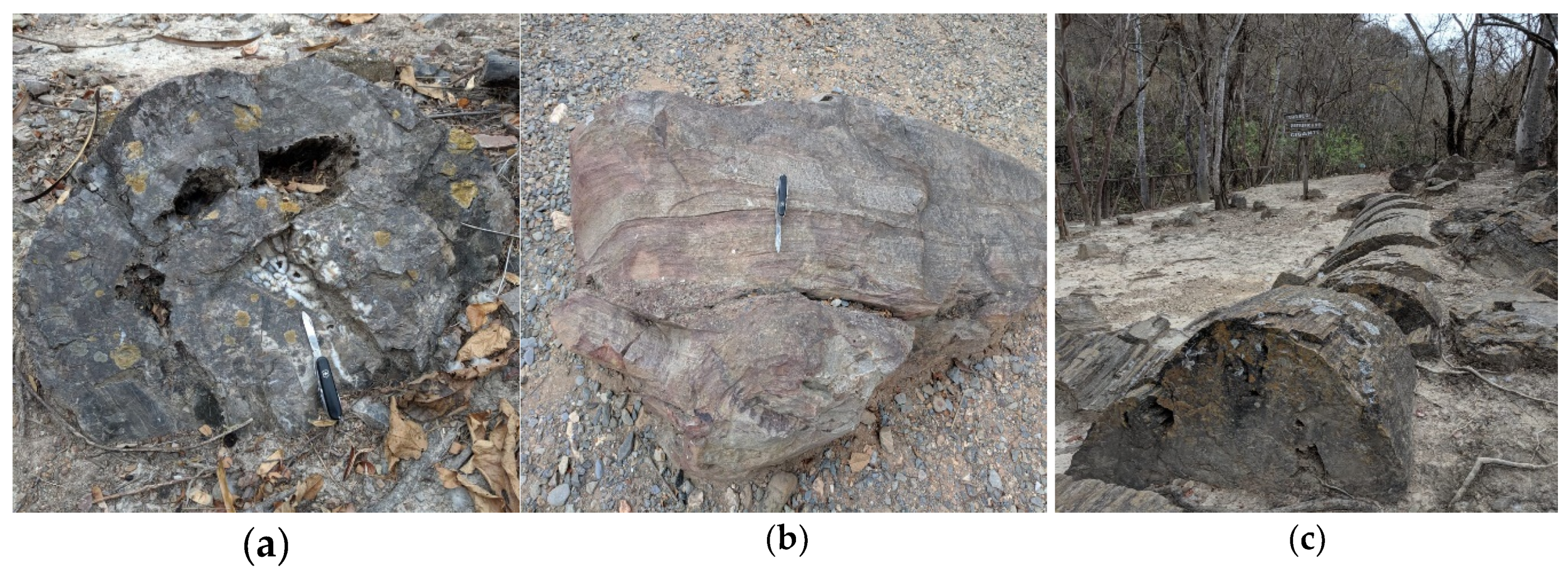
| 1 | PPF Tourist trail | Volcano-sedimentary rocks. | It contains abundant remains of well-preserved petrified trunks. | It is a guided tourist route in the tropical dry forest (fauna and flora). |
| 2 | Sábalos stream | Geological domain: Alamor, Lancones Basin. At the base, some ortho-quartzites and conglomerates rest discordantly on the Amotape, Tahuin massif. Black marl, massive layers of limestone and banded black shales, clays, siltstones and sandstones with lava and sedimentary volcano rocks. | It contains abundant remains of petrified trunks corresponding to Araucariaceas. | The trunks are well preserved, practically intact of large dimensions, the only fossil specimens resulting from the fossilization process of petrification, product of the replacement of organic matter by silica. |
| 3 | Cochurco stream | Volcanic materials and sedimentary limestones and shales. | Remains of fossil roots (charred), remains of petrified trunks. Fossil invertebrates, present as internal and external moulds. | A petrified trunk of Araucariaceas well preserved, in a significant vertical position. |
| 4 | Chirimoyo stream | Geological deformations (folds) in sedimentary rocks represented by clay. | Remains of fossil invertebrates: Pelecypods, Inoceramus and Ammonites; and microfossils: planktonic and benthic foraminifera, calcareous nanofossils and Palinomorphs. | Invertebrate marine fauna is very frequent. |
| 5 | El Limón stream | Geological deformations, fold (anticline) in volcano-sedimentary rocks. Calcareous rocks (Coquina type). | Petrified trunks well preserved. Invertebrate fossils: foraminifera and calcareous nanofossils. | Petrified (carbonized) trunks, in which the cellulose of the trees was transformed into anthracite due to the loss of methane, water and carbon dioxide. This geosite has a potential area to recreation (crystal clear lagoon). |
| 6 | El Guineo stream | It shows stratifications by the alternative deposit of sediments of different composition. | Fossil invertebrates: a phylum of molluscs, bivalves and ammonites and petrified trunks. | Pelecypod prints. |
| 7 | Gringo Beach | Volcano-sedimentary rocks, limestones, shales and clays. | Fossil invertebrates: a phylum of molluscs, bivalves and ammonites. | Vegetable fossil remains, from fossilization processes (carbonization). |
| 8 | Las Concreciones stream | Limestone outcrop associated with a core of Ammonites. Shales, marls and thin layers of clays. The limestones inside have pyrite. | Ammonite concretions. Molluscs, foraminifera and calcareous nanofossils and ostracods. | A unique geosite: can be shown calcareous concretions. |
| 9 | Las Palmas stream | Volcano-sedimentary rocks. | Remains of allochthonous petrified trunks. | Little diversity of petrified trunks. |
| 10 | Quemazón stream | Geological deformations, folding and thrust in limestone rocks. | Appears a few remains of petrified (charred) trunks. | Fossilization processes (carbonization). |
| 11 | Tunima stream | Volcano-clastic rocks, with levels containing petrified trunks. | Petrified trunks well preserved. | Petrified trunk in volcano-clastic rocks with a diameter smaller than found in Sábalos and Chocurco streams. |
| 12 | Puyango River course | Geographical reference whose cause has an altitude of 200 m.a.s.l, is the water axis of importance for the ENE-WSW direction according to the structural limits of the sector. | Allochthonous petrified trunks. | Appears remains of petrified trunks and fossil invertebrates. |
| 13 | Puyango, Alamor trail | None. | Allochthonous petrified trunks. | None. |
| 14 | El Tigre stream | Volcano-sedimentary sediments reddish color due to the presence of iron oxides. | Vegetable fossil remains (fossilized leaf) by fossilization processes (carbonization). | The only geosite with a petrified leaf specimen in the fossilization process (carbonization). |
| 15 | La Libertad fold | Metamorphic deformations. Anticline fold. | Geosite without paleontological remains. | Geological deformations due to compressive stresses. |
| 16 | Playón Las Pailas | Appears deposits of visible material of sedimentary rocks along the river bed in the dry season. | Sedimentary rocks carbonated, with remains of invertebrates. | Recreational tourist place for organized activities. |
| 17 | PPF Interpretation left | Exists geological information (samples of rocks and calcareous concretions). | Petrified trunks, fossils. Recreation area, location maps of the main gorges, paleontological information. | Disclosure area. |
| Value | Indicators/Parameters | Description |
|---|---|---|
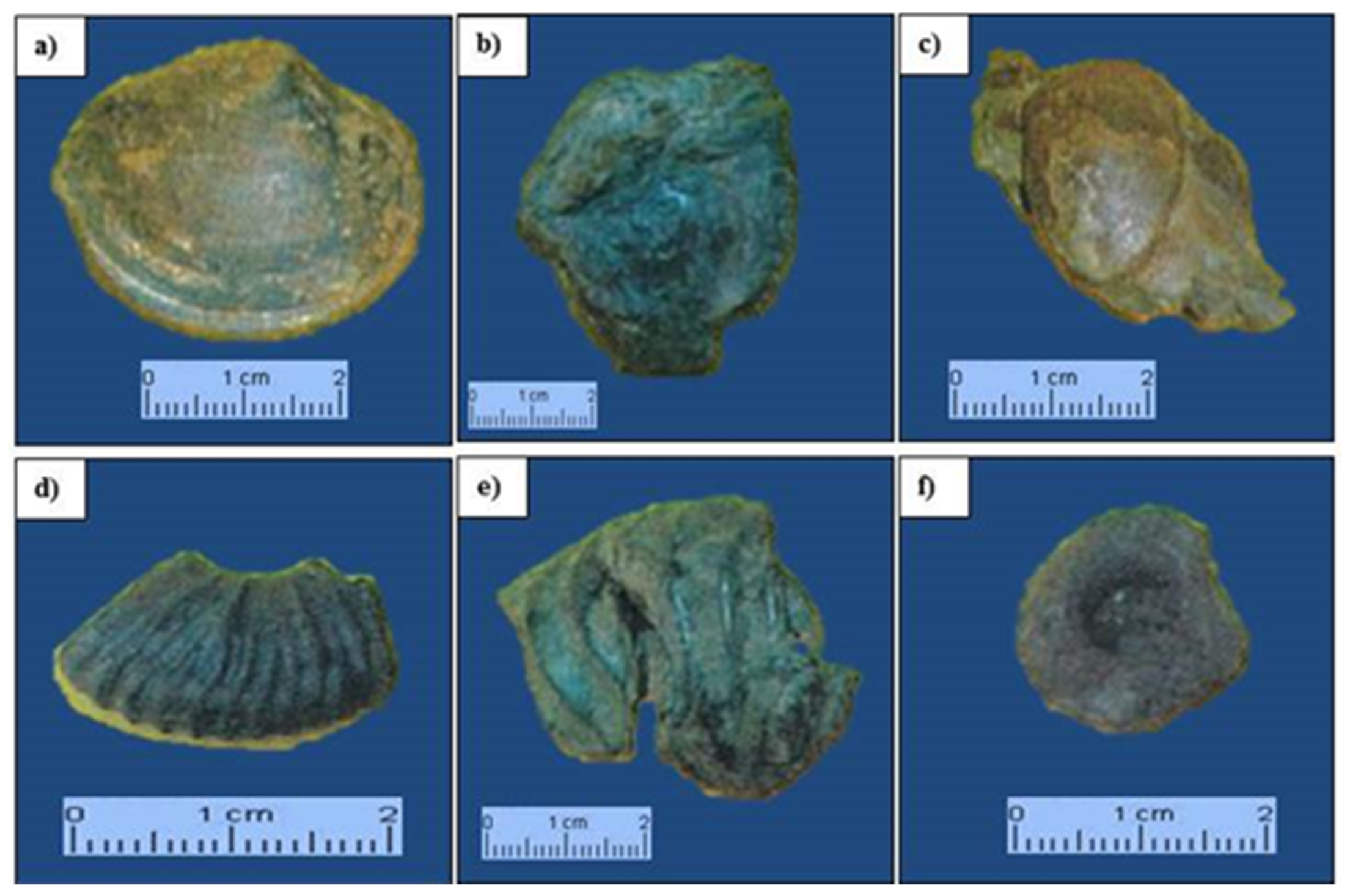
| Scientific value | Representativeness | The Puyango Petrified Forest (PPF) is a source of knowledge and well-being and it is the unique place with the best paleontological exposure in Ecuador. The area shows a sequence of volcano-sediment from the Cretaceous age (Albian-Middle). A collection of petrified trunks, fossilized leaves of common gymnosperms and remains of mollusk shell molds of the Southern Cretaceous have been found in PPF deposits. |
| Prototype location character | PPF is a site of geological interest and a good example of a paleontological deposit, where specimens of petrified trunks and other allochthonous from Aptian-Middle and Jurassic-Cretaceous are found in situ. | |
| Degree of scientific knowledge of the place | There are several works published in national and international journals performed by geoscientists and theses carried out by students and professionals on geological, paleontological, archaeological, botanical, cultural, economic and tourism topics. | |
| State of conservation | PPF presents a regular state of conservation. Some deteriorated areas prevent the observation of geological characteristics (landslides). Some information panels are partially deteriorated. | |
| Observation conditions | The observation of several silicified trunks of Araucariaceas and Metapodocarpoxylon specimens, marine invertebrate fossils of the phylum Mollusca of the pelecypods class and cephalopod (ammonoids) possible. The fossilized flora corresponds to the subphylum of the mid-Mesozoic gymnosperms of the Zamites, Dioonites, Nilssonia, Otozamites, Podozamites, Carpites, and other genera. It is also a dry-tropical forest ecosystem that preserves species (fauna and flora) existing today. | |
| Rarity | The petrified trunks of Puyango represent one of the largest collections of petrified wood in Ecuador and probably in the world. The site has unique characteristics from the Cretaceous Period. | |
| Geological diversity | The paleontological aspect stands out as the main geological interest, followed by the stratigraphic, sedimentological, structural and geological history. Secondary features are the historical/archaeological, biodiversity, cultural and landscape. | |
| Educational potential and touristic use | Didactic content | Educational visits and excursions from schools, colleges, and universities take place considering the protection of the geological-paleontological heritage of the place. |
| Logistics infrastructure | It lacks nearby accommodations and restaurants for tourist groups, but it has an interpretation and information left for tourists. | |
| Accessibility | Using a national highway there is the access Guayaquil-Machala-Arenillas-Puyango with a 276 km route. From Huaquillas (border with Peru), there are 62 km. Another access road goes from Loja-Veracruz- Catacocha’s city through a state highgway and then El Empalme-Celica-Alamor-Puyango with a distance of 213 km [26]. | |
| Association with other elements of the natural and/or cultural heritage | Numerous archaeological remains (petroglyphs) found in different parts of the Puyango canton. | |
| Magnificence or beauty | Landscape, river course, remains of plant fossils and invertebrates as evidence of ancient times. | |
| Informative content/Informative use detected | Limited and without a tourist information department. | |
| Potential to carry out touristic and recreational activities | It has touristic trails, fossil deposits and streams. | |
| Proximity to recreational areas (immediate potential demand) | There is a camping area less than 500 m from the forest. | |
| Socioeconomic environment | The most common economic activities are the short cycle crops sowing and coffee, cattle and pig raising. | |
| Fragility | LIG size | Area of 2.6 ha. with 17 LIGs. |
| Vulnerability to plunder | A paleontological site of great value, with numerous specimens and easy plunder. | |
| Natural threats | Possible landslides, flooding of rivers, weakening of the soil and climatic variations due to severe droughts. | |
| Vulnerability due to anthropogenic threats | Proximity to anthropic activities (infrastructure) | Place not threatened. |
| Interest for mining | No mining interest in the area. | |
| Site protection regime | Cultural Heritage, Ordinance for the Declaration of the Bi-provincial Protected Area, in the Category of Ecological Conservation Area. | |
| Physical or indirect protection | Protected area with access to tourists. | |
| Accessibility (potential assault) | It is directly accessible through unpaved and passable track for tourism. | |
| Place ownership regime | Location in restricted access areas declared as natural heritage. | |
| Population density (potential aggression) | The town is located at the entrance to the forest tourist complex that belongs to the province of El Oro, Las Lajas canton. It has an economically active population of approximately 200 people, mostly farmers [26]. |
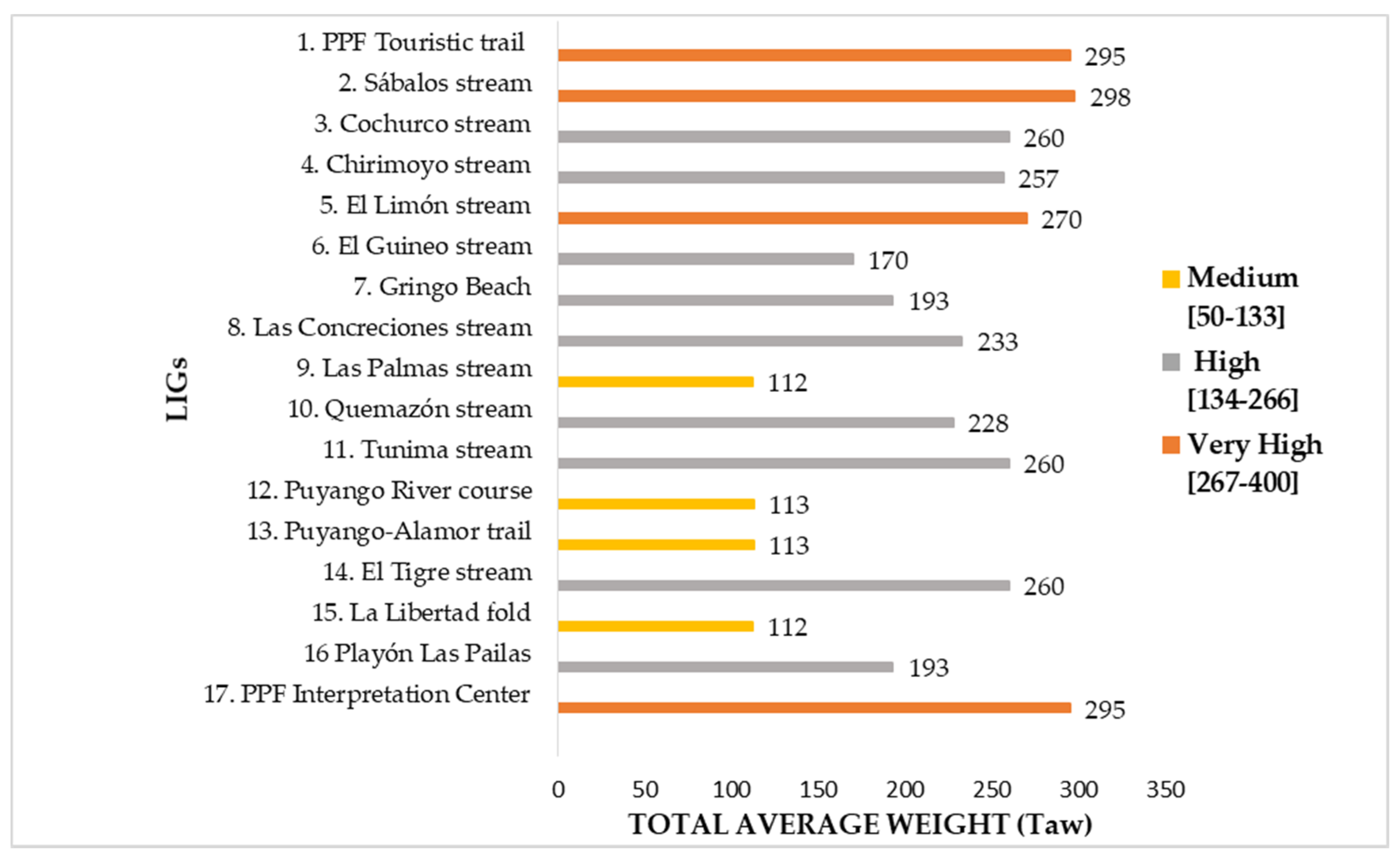
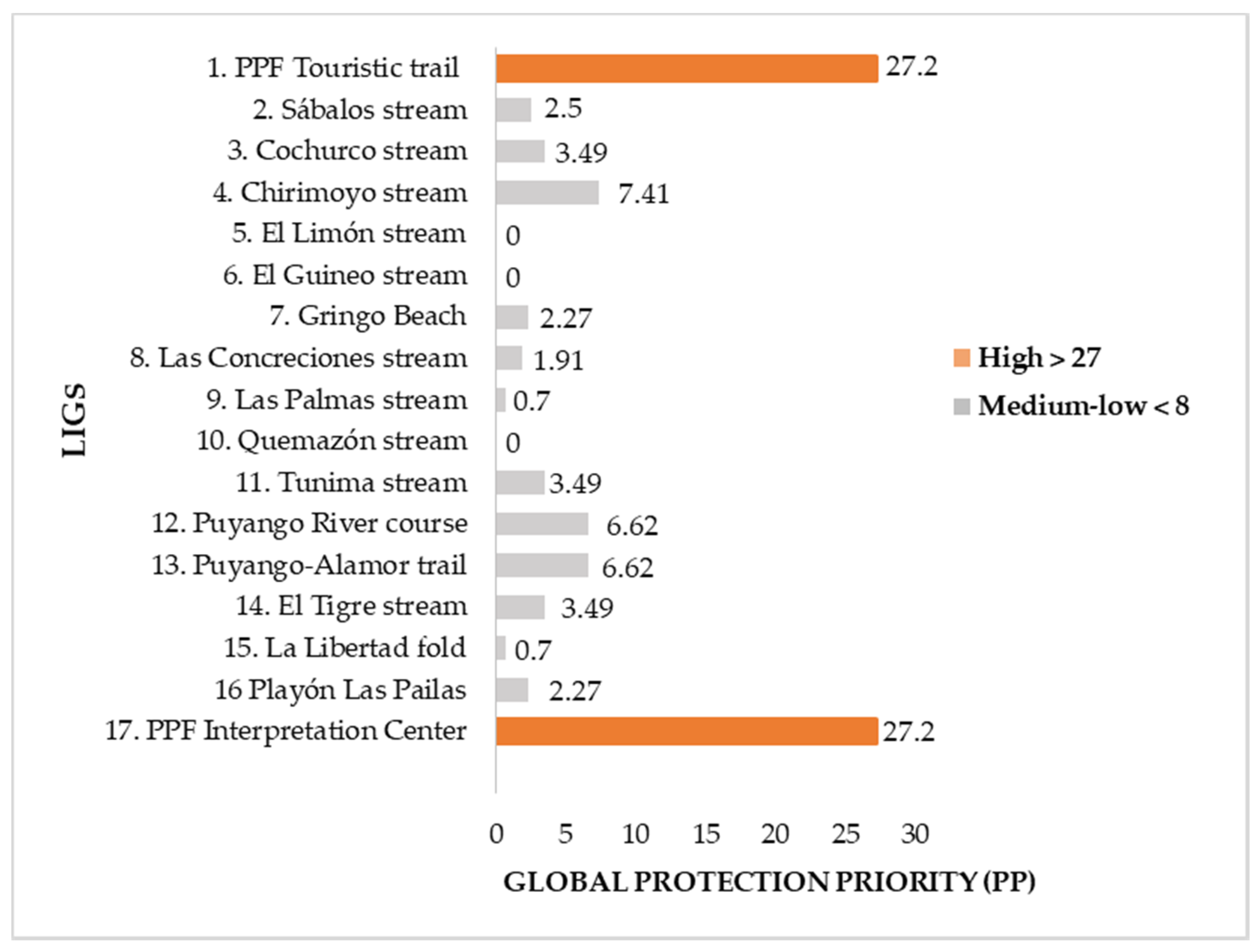
| N° | LIGs | Si | Di | Ti | Taw | GI | SD | SPP | DPP | TPP | PP | PPG |
|---|---|---|---|---|---|---|---|---|---|---|---|---|
| 1 | PPF Touristic trail | 380 | 275 | 230 | 295 | Very High | 50 | 45.13 | 23.63 | 16.53 | 27.20 | High |
| 2 | Sábalos stream | 360 | 250 | 285 | 298 | Very High | 4.50 | 3.65 | 1.76 | 2.28 | 2.50 | Medium-low |
| 3 | Cochurco stream | 320 | 225 | 235 | 260 | High | 8.25 | 5.28 | 2.61 | 2.85 | 3.49 | Medium-low |
| 4 | Chirimoyo stream | 330 | 215 | 225 | 257 | High | 18 | 12.25 | 5.20 | 5.69 | 7.41 | Medium-low |
| 5 | El Limón stream | 335 | 215 | 260 | 270 | High | 0 | 0 | 0 | 0 | 0 | Medium-low |
| 6 | El Guineo stream | 185 | 150 | 175 | 170 | High | 0 | 0 | 0 | 0 | 0 | Medium-low |
| 7 | Gringo Beach | 240 | 165 | 175 | 193 | High | 9.75 | 3.15 | 1.66 | 1.87 | 2.27 | Medium-low |
| 8 | Las Concreciones stream | 270 | 175 | 255 | 233 | High | 5.63 | 2.56 | 1.08 | 2.29 | 1.91 | Medium-low |
| 9 | Las Palmas stream | 110 | 80 | 145 | 112 | Medium | 9 | 0.68 | 0.36 | 1.18 | 0.70 | Medium-low |
| 10 | Quemazón stream | 305 | 170 | 210 | 228 | High | 0 | 0 | 0 | 0 | 0 | Medium-low |
| 11 | Tunima stream | 320 | 225 | 235 | 260 | High | 8.25 | 5.28 | 2.61 | 2.85 | 3.49 | Medium-low |
| 12 | Puyango River course | 110 | 90 | 140 | 113 | Medium | 82.50 | 6.24 | 4.18 | 10.11 | 6.62 | Medium-low |
| 13 | Puyango-Alamor trail | 110 | 90 | 140 | 113 | Medium | 82.50 | 6.24 | 4.18 | 10.11 | 6.62 | Medium-low |
| 14 | El Tigre stream | 320 | 225 | 235 | 260 | High | 8.25 | 5.28 | 2.61 | 2.85 | 3.49 | Medium-low |
| 15 | La Libertad fold | 110 | 80 | 145 | 112 | Medium | 9 | 0.68 | 0.36 | 1.18 | 0.70 | Medium-low |
| 16 | Playón Las Pailas | 240 | 165 | 175 | 193 | High | 9.75 | 3.15 | 1.66 | 1.87 | 2.27 | Medium-low |
| 17 | PPF Interpretation Center | 380 | 275 | 230 | 295 | Very High | 50 | 45.13 | 23.63 | 16.53 | 27.20 | High |
| N° | LIGs | UTM Coordinates | Type of Interest | Accessibility | Sensitivity | Conservation Status | |||
|---|---|---|---|---|---|---|---|---|---|
| Si | Di | Ti | Pi | ||||||
| 1 | PPF Tourist trail | 601735E, 9560324S | ✓ | ✓ | ✓ | ✓ | Good | Average | Good |
| 2 | Sábalos stream | 602734E, 9570326S | ✓ | ✓ | ✓ | ✓ | Good | Average | Good |
| 3 | Cochurco stream | 606966E, 9572143S | ✓ | ✓ | ✓ | ✓ | Good | Poor | Good |
| 4 | Chirimoyo stream | 603047E, 9563869S | ✓ | ✓ | ✓ | Below average | Poor | Good | |
| 5 | El Limón stream | 606437E, 9571676S | ✓ | ✓ | ✓ | ✓ | Below average | Poor | Below average |
| 6 | El Guineo stream | 598773E, 9567082S | ✓ | ✓ | Below average | Poor | Below average | ||
| 7 | Gringo Beach | 600022E, 9573244S | ✓ | ✓ | ✓ | Below average | Poor | Good | |
| 8 | Las Concreciones stream | 602810E, 9570930S | ✓ | ✓ | Poor | Poor | Below average | ||
| 9 | Las Palmas stream | 600442E, 9571602S | ✓ | ✓ | ✓ | Below average | Poor | Good | |
| 10 | Quemazón stream | 603298E, 9570534S | ✓ | Good | Poor | Below average | |||
| 11 | Tunima stream | 612035E, 9570322S | ✓ | Below average | Poor | Good | |||
| 12 | Puyango River course | 601926E, 9570859S | ✓ | ✓ | Regular | Poor | Below average | ||
| 13 | Puyango-Alamor trail | 602305E, 9567823S | ✓ | ✓ | Good | Poor | Below average | ||
| 14 | El Tigre stream | 605566E, 9571653S | ✓ | ✓ | Good | Below average | Average | ||
| 15 | La Libertad fold | 600021E, 9573243S | ✓ | ✓ | Below average | Below average | Below average | ||
| 16 | Playón Las Pailas | 606828E, 9571865S | ✓ | ✓ | Good | Below average | Average | ||
| 17 | PPF Interpretation Center | 601354E 9568864S | ✓ | ✓ | ✓ | Good | Below average | Below average | |
| Internal environment | Strengths | Weaknesses | |
| External environment | S1. Puyango is the unique petrified forest of Cretaceous-Aptian age in the country and it has international relevance. S2. It has an outstanding scientific interest due to the exceptional type of fossilization of the petrified trunks. S3. It was declared the Ecuadorian a Cultural Heritage Treasure. S4. The unique forest that combines petrified and natural trees. It is the habitat of 65 species of birds and other animals. | W1. Lack of “social awareness” necessary in a geological-paleontological and cultural heritage. W2. Lack of infrastructure and tourist care services (emergency ward, restaurants, and lodgings). W3. Lack of a bilingual tourist information center that provides scientific and relevant information W4. Lack of internet access and media communications. | |
| Opportunities | Strategy: Strengths + Opportunities | Strategy: Weaknesses + Opportunities | |
| O1. Geopark Project proposal under development by government entities and universities. O2. Protection and restoration of LIGs through various strategies with national and international organizations. O3. Geotourism development open to improvement. O4. Declare PPF as a Biosphere Reserve (BR) in the dry forest of southern Ecuador. It is a strategic opportunity. | S1.O1. Complement studies to generate a database of scientific information on paleontological resources. S2.O2. Develop strategies for the sustainable management of cultural and natural resources: conservation, research, and development for the proposal of the Puyango Geopark project. S3.O3. Undertake conservation and cleaning work on fossil outcrops, protection of specimens in situ, an adaptation of trails and placement of information panels. | W1.O1. Participatory Geopark proposal that integrates geodiversity, biodiversity, territory and people. W2.O2. Promote Social Management programs (training and awareness) that involve rural families in the management of resources. W4.O4. Promote the management of information, production and popularization of knowledge and tourism promotion at national and international level, through ICTs. | |
| Threats | Strategy: Strength + Threats | Strategy: Weaknesses + Threats | |
| T1. The burning of vegetation to obtain new land for planting. T2. Deforestation and overgrazing that degrades the ecosystem. T3. Collection of samples without approval from Authorities. T4. Demand from the neighboring country Peru for the pollution of the Puyango River due to mining effects outside the PPF [36]. T5. Possible landslides, river floods and climatic variations due to severe droughts. | S2.T4. Encourage the development of good bilateral relations with the neighboring country Peru. This strategy stabilizes the intra-border situation and encourages Peruvian tourism to the PPF area. S3.T3.T4. Recovery of the paleontological deposit of fossil outcrops of trees and marine invertebrates from the PPF and nearby areas such as the Piedmont of the Tumbesina eco-region (Ecuador-Peru). S4.T3. Legal regulations with permanent control on all activities within the forest, such as trail management, conservation, staff performance, tour operators, transportation income, agricultural production, etc. | W1.T1. Promote sustainable tourism and mitigation of local anthropogenic threats. W2.T2. To plan and promote the reforestation in selected areas through a pilot program, all together with farm owners within the forest has protected area to establish a mining-environmental order. W3.T3. Find private investors for the construction of a tourist accommodation and recreation center. W4.T4. Build a permanent Information Center and administrative offices, according to the regulations to certify the area as an eco-touristic site. | |
© 2020 by the authors. Licensee MDPI, Basel, Switzerland. This article is an open access article distributed under the terms and conditions of the Creative Commons Attribution (CC BY) license (http://creativecommons.org/licenses/by/4.0/).
Share and Cite
Morante-Carballo, F.; Herrera-Narváez, G.; Jiménez-Orellana, N.; Carrión-Mero, P. Puyango, Ecuador Petrified Forest, a Geological Heritage of the Cretaceous Albian-Middle, and Its Relevance for the Sustainable Development of Geotourism. Sustainability 2020, 12, 6579. https://doi.org/10.3390/su12166579
Morante-Carballo F, Herrera-Narváez G, Jiménez-Orellana N, Carrión-Mero P. Puyango, Ecuador Petrified Forest, a Geological Heritage of the Cretaceous Albian-Middle, and Its Relevance for the Sustainable Development of Geotourism. Sustainability. 2020; 12(16):6579. https://doi.org/10.3390/su12166579
Chicago/Turabian StyleMorante-Carballo, Fernando, Geanella Herrera-Narváez, Nelson Jiménez-Orellana, and Paúl Carrión-Mero. 2020. "Puyango, Ecuador Petrified Forest, a Geological Heritage of the Cretaceous Albian-Middle, and Its Relevance for the Sustainable Development of Geotourism" Sustainability 12, no. 16: 6579. https://doi.org/10.3390/su12166579
APA StyleMorante-Carballo, F., Herrera-Narváez, G., Jiménez-Orellana, N., & Carrión-Mero, P. (2020). Puyango, Ecuador Petrified Forest, a Geological Heritage of the Cretaceous Albian-Middle, and Its Relevance for the Sustainable Development of Geotourism. Sustainability, 12(16), 6579. https://doi.org/10.3390/su12166579