Review

Knowledge Mapping Analysis of Rural Landscape Using CiteSpace

1
Department of Landscape Architecture, College of Horticulture and Forestry, Huazhong Agricultural University, Wuhan 430070, China
2
Key Laboratory of Urban Agriculture in Central China, Ministry of Agriculture and Rural Affairs, Wuhan 430000, China
3
Wuhan Landscape Construction development (Group) CO., LTD., Wuhan 430000, China
4
Institute of Geography, Faculty of Physics and Earth Sciences, Leipzig University, 04103 Leipzig, Germany
*
Authors to whom correspondence should be addressed.
Sustainability 2020, 12(1), 66; https://doi.org/10.3390/su12010066
Submission received: 16 November 2019 / Revised: 11 December 2019 / Accepted: 12 December 2019 / Published: 20 December 2019
(This article belongs to the Section Sustainable Urban and Rural Development)

Abstract

:
This study visualizes and quantifies extant publications of rural landscape research (RLR) in Web of Science using CiteSpace for a wide range of research topics, from a multi-angle analysis of the overall research profile, while providing a method and approach for quantitative analysis of massive literature data. First, it presents the number of papers published, subject distribution, author network, the fundamental condition of countries, and research organizations involved in RLR through network analysis. Second, it identifies the high-frequency and high betweenness-centrality values of the basic research content of RLR through keyword co-occurrence analysis and keyword time zones. Finally, it identifies research fronts and trending topics of RLR in the decade from 2009 to 2018 by using co-citation clustering, and noun-term burst detection. The results show that basic research content involves protection, management, biodiversity, and land use. Five clearer research frontier pathways and top 20 research trending topics are extracted to show diversified research branch development. All this provides the reader with a general preliminary grasp of RLR, showing that cooperation and analysis involving multiple disciplines, specialties, and angles will become a dominant trend in the field.

1. Introduction

Landscape refers to an area perceived by people, which is the outcome of interaction between nature and/or human factors [1]. For thousands of years, human beings have created landscapes through agriculture. Sereni [2], an agricultural historian, wrote, ‘the agrarian landscape is the form that man, in the course and for the ends of his agricultural productive activities, impresses on the natural landscape’. In 2017, ICOMOS (International Council on Monuments and Sites) and IFLA (International Federation of Landscape Architects) jointly formulated a principle concerning rural landscapes as an important part of human heritage [3]. As one of the most common types of sustainable cultural landscapes, the research of rural landscapes is receiving increased attention from researchers, and their results are constantly developing and being updated.
According to a search of Elsevier’s Scopus and Thomson Reuters’ Web of Science (WoS) citation database, there are only a few review papers on rural landscape research (RLR). An article by Sitzia et al. [4] that reviewed 52 papers on the impact of forest land on rural landscape based on landscape indicators or index analysis has been cited up to 85 times. Xie and Liu [5] reviewed the research progress of rural landscape evaluation. Chen et al. [6] gave a brief summary of the primary contents of RLR in China in recent years. Along with the progress achieved in the field so far, it is also important to determine and analyze the overall state of rural landscapes. Owing to the limits of technology, traditional literature analysis methods mostly rely on scholars’ efforts to consult and select articles. Bonthoux et al. [7] and Rigolon [8] selected several dozen articles by manual screening for analysis. Meerow et al. [9] reduced the number of articles searched by using more specific search terms. Wang et al. [10] analyzed 14,338 articles concerning urbanization from Science Citation Index (SCI) and Social Sciences Citation Index (SSCI) databases, with more comprehensive data, but mainly adopted the analysis function of WoS itself.
Due to evolving demands for data and information visualization, in 2003, the US National Academy of Sciences proposed the concept of mapping knowledge domains that describe a newly evolving interdisciplinary area of science aimed at the process of charting, mining, analyzing, sorting, navigating, and displaying knowledge [11]. Chen [12] then used this concept to develop CiteSpace, a tool that provides a more scientific bibliometric analysis method for a large number of publications and which could be diagrammatized clearly. It has since become one of the most representative knowledge mapping tools.
Taking bibliometrics citation and co-occurrence analysis as its theoretical basis, this study utilizes CiteSpace to quantitatively analyze existing articles on RLR. It has the aims of understanding the overview of RLR, explaining the main research’s basic content, and discerning trending research topics. It attempted to find logical association paths for research fronts, obtained the development of RLR branches, and determined the literatures that demand intensive reading to make the research frontier pathways more logical and scientific. In addition, the methods and paths of this study provide a valuable, visual, repeatable, and practical approach to complement traditional systematic reviews and overcome the limitations of previous research. This will allow for a thorough understanding of the themes and trends of RLR, fill the gap in the review of overall rural landscape, and provide theoretical references for further research.
The structure of this article is as follows. The Section 2 introduces the data collection and research methods. The Section 3 shows the research results from three aspects: the research overview, the main research’s basic content, then the fronts and trending topics of RLR in the past ten years. Section 4 summarizes the overall situation of RLR and the existing problems and proposes suggestions for future research.

2. Materials and Methods

2.1. Data Collection

Based on the WoS core collection platform, the Science Citation Index Expanded (SCI-E) and Social Sciences Citation Index (SSCI) databases were selected as data sources. The first article on rural landscape was recorded in 1936. To minimize the omission of important basic studies from earlier years, the time span for data extraction was set from 1936 to December 31, 2018. After several tests, we employed the retrieval type ‘(rural* or village* or countryside*) and (landsc* or scenery or scenic*)’; the wildcard character ‘*’indicates that any word beginning with the preceding letters should be taken into account. A total of 8119 publications were found when searching the ‘Topic’ (which covers the article title, abstract, author, keywords, keywords plus, and country) as the retrieval item; of these, 7581 journal articles were selected (data retrieval time: 14:15, 21 February 2019). No further selection was performed for geography, ecology, or landscape science, based on the comprehensiveness of the research, publication type, subject category, and research institute.

2.2. Analytical Methods

2.2.1. CiteSpace

CiteSpace is a Java-based application [13]. As a scientific literature data mining and visualization software, it combines cluster analysis, social network analysis, and many other methods. Its novelty lies in the deep excavation of co-citation data of scientific research articles, investigation of knowledge structure in relevant knowledge fields, detection of research development trends and correlations, and identification of betweenness centrality between pivotal points in scientific literature. It can be used to explore the dynamics of a specialty in terms of a time-variant mapping from a research front to its intellectual base; it then presents these information in the form of a color atlas.

2.2.2. Setting of CiteSpace

The 7581 selected articles were imported into CiteSpace, with each time slice set to one year. Because the highest number of publications in a single year within the specified time span was 782 articles in 2018, we specified Top N = 782 to enable full visual analysis of the data. As explained above, we first set to the entire time period; this helped to provide a research overview and topics from the entire base in accordance with the citation frequency, betweenness centrality, and the other base for screening. Research frontiers and trending topics with strong timeliness were searched across the past ten years (set at 2009–2018), and the remaining factors were set by default in the software.
The atlas is mainly presented in the form of nodes and lines, N = the number of nodes, E = the number of lines. The size of nodes reflects the frequency of relevant data references or occurrences, the lines indicate the relationship between the nodes, and the thickness of the lines between nodes reflects the strength of links between data. The nodes and lines in the figures are not fully rendered due to the clarity and visualization, and the circular purple outer nodes represent the amount of betweenness centrality to judge the media effect of papers. The clustering effect was measured using modularity and silhouette. The Q value represents the degree of modularity; Q ≥ 0.3 means that the modularization of the network is significant, and as the value of Q increases, the clustering effect of the network improves. Silhouette (S) measures the homogeneity of networks; S ≥ 0.5 means that the result of clustering is reasonable, and as S moves closer to 1, the homogeneity of the network will increase.

2.2.3. Paths of Analysis

There were four primary paths of analysis, which were all performed utilizing CiteSpace.
  • Network analysis: this enabled us to determine the general state of RLR, including the number of publications, countries of relevant journals, subject distribution, and cooperation networks of organizations and authors. The time span of the analysis was from 1936 to 2018.
  • Co-occurrence analysis and time zone chart of keywords: combining the analysis of high-frequency and high betweenness-centrality keywords and the keyword time zone map, the intellectual base of RLR was determined. The time span of the analysis was from 1936 to 2018.
  • Co-citation clustering analysis of the research fronts: research front consists of a cluster of co-cited core papers as well as the group of current source papers that cite one or more of these core papers [14]. By clustering the citing references of the co-cited references, the noun terms were extracted to name the co-citation clustering of articles. Next, the frequently cited references were screened in accordance with these clusters, and the resulting articles were subjected to intensive reading to understand the current frontiers of RLR. The selected time span was 2009–2018.
  • Noun-term burst detection: Burst-detection algorithms are used to identify emergent terms regardless of how often their host articles are cited [15]. It is a phenomenon wherein the noun terms to be investigated transit in a short time, which emphasizes a sudden change, outburst, or sharp increase within a period. Based on noted word-frequency trends across time, trending research topics can be discerned. The selected time span was from 2009 to 2018.

3. Results and Discussion

3.1. Overview of Rural Landscape Research

3.1.1. Number of Papers Published

Since 1936, the amount of research has tended to increase year by year, with particularly high growth rates in 2006, 2009, 2015, and 2017. The growth rate peaked in 2017, and the largest number of articles (782) was published in 2018.

3.1.2. Distribution of Research Disciplines

The subject distribution status of RLR can be obtained by visualizing the results through the ‘Category’ option in CiteSpace. After simplifying and merging the data with the same subject, 139 nodes and 209 lines were extracted, and betweenness-centrality analysis was performed (Figure 1). This analysis showed that RLR is involved in more than one hundred disciplines. In five of these disciplines, the number of articles published exceeded 1000, including the disciplines of environmental sciences and ecology, ecology, environmental sciences, environmental studies, and geography. The betweenness-centrality value exceeded 0.1 in 11 disciplines (e.g., engineering, social sciences and interdisciplinary, agriculture, and environmental sciences and ecology). Although there were few publications in some disciplines (e.g., psychology, social sciences and interdisciplinary), the betweenness-centrality value was relatively high, reflecting that these disciplines play a pivotal role in the construction of the interdisciplinary collaboration and research system. In addition, according to the intensity value of the connection lines, environmental sciences and ecology has a strong connection with similar fields such as environmental studies, and also has close interdisciplinary relationships with other subjects, such as geography, urban study, public administration, agriculture, and social sciences, among others.

3.1.3. Authors of Core Articles

In the mapping knowledge domain of author cooperation in CiteSpace, there were 1058 nodes and 1408 lines that connected the nodes. Among them, 18 authors published more than ten articles. Salvati, who published the largest number of articles, had 47 articles included in the WoS database. Moreover, there were relatively dominant academic associations. Among them were Verburg, Plieninger, Fischer, Hartel, Hanspach, and some other authors (Figure 2). Their academic backgrounds include agriculture, environmental geography, ecology, agricultural sociology, landscape ecology, etc., showing the interdisciplinary relationships.

3.1.4. Countries of Articles’ Origin

The cooperation network of countries showed 110 nodes and 909 lines connecting the nodes, among which, scholars in the United States published the largest number of articles (1958). A total of 12 countries published more than 200 articles. The betweenness centrality in France, New Zealand, Switzerland, the United States, Britain, Germany, and Belgium, was more than 0.1 (Figure 3). Most of the high volume of publications and high betweenness-centrality values were found in European countries, likely due to the similar natural and geographical environment that makes European countries form strong research links. European countries’ alliances and organizations on landscape research, as well as the formulation and promulgation of some conventions and policies, have important significance for the research and development of rural landscapes and have been widely used for reference. These include the European Landscape Convention of the Council of Europe, which promotes the protection, management, and planning of the landscapes and organizes international co-operation on landscape issues.

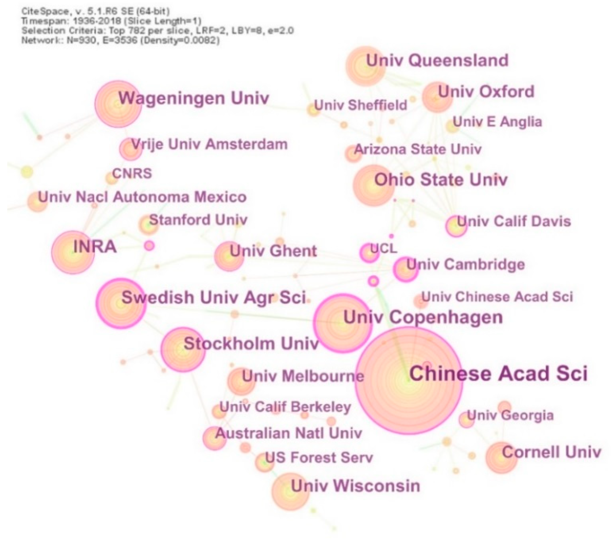
3.1.5. Research Organizations

CiteSpace showed 930 nodes and 3536 lines for the organizations where research was conducted. Among these, 11 organizations published more than 60 articles in the field. Chinese Academy of Sciences had the largest number of papers published, with 138 articles in the WoS database. Three research organizations, Chinese Academy of Sciences, University of Copenhagen, and University of Cambridge, had a betweenness-centrality value over 0.1, reflecting their importance and influence in the field (Figure 4). Comparative analysis showed a direct correlation between the number of papers published by researchers at specific organizations and the number of papers published in countries where those organizations were located. For example, researchers at the University of Wisconsin, Ohio State University and Stanford University in the United States published numerous papers on RLR, which contributed to the high number of papers published in the United States.

3.2. Themes and Fields of Rural Landscape Research

According to the results of the keywords co-occurrence analysis, by eliminating the retrieval terms, the four keywords that have been used over a long time and have high-frequency (Frequency over 700) were ‘protection’ (1034), ‘biodiversity’ (839), ‘management’ (829), and ‘land use’ (707),which can thus be considered the major fields and basic contents of RLR (Figure 5). The keyword time zone map shows these four high-frequency keywords began to appear in 1984, probably because the keywords of the early literature were not included in WoS. Of these, land use, protection, and management have a relatively high betweenness-centrality value and are media keywords for multidisciplinary and interdisciplinary studies of rural landscapes (Figure 6). In addition, the frequency of co-occurrence of key words such as urbanization, agriculture, forests, and diversity all exceeded 400. Among them, urbanization and agriculture have relatively high betweenness-centrality values. In each subject area, we selected representative articles based on the frequency of citations from high to low and more closely related to the topic and analyzed the research contents.
The rural landscape takes the ecological, environmental, and historical and cultural aspects as protection objects [16,17,18], and the local residents as the main protection subject [19,20,21,22]. Research on rural landscape protection has appeared early, frequently, and with strong intermediary centrality, which is the ultimate goal and purpose of the RLR. Rural landscape management aims to plan and assess land use and human activities in rural areas, coordinate with various stakeholders and interest groups, maintain landscapes at appropriate spatial scales and time periods, and ensure the economic, social, and environmental sustainability of ecosystems and resources [23]. Rural landscape management is the avenue for the application of many RLR results [23,24,25,26,27,28,29]. Land use is the carrier and substrate of rural landscape, which leads to changes in the natural and human environment of rural landscapes under the interaction of different time, space, and intensities [30,31,32,33,34,35,36]. The biodiversity and ecological functions of rural landscapes have also been the focus of scholars [37,38]. As the most common form of rural landscape, agricultural landscapes with diverse structures are key habitats in stimulating and protecting biodiversity [39,40,41,42].
In addition, these keywords do not always exist independently, but often present a related research status, For example: the impact of changes in agricultural models on traditional land use [43,44,45,46] and the protection of different agricultural substrates on biodiversity [47,48,49,50]. Negative correlations were found between increased land use intensity and heterogeneity of rural landscapes, habitat diversity, species richness, and biodiversity [38,40,51,52]. The dynamic changes of urbanization have led to new patterns in rural landscapes [53,54]. Landscape indicators in landscape ecology are often combined with urban gradient analysis and are widely used to study changes in rural landscape patterns [51,55,56,57,58,59,60,61,62,63].

3.3. Frontiers and Trending Topics of Rural Landscape Research in the Past Decade

3.3.1. Frontiers of Rural Landscape Research

The co-citation clustering view of RLR was generated with cited references as node types, and the maximum displays in each time slice are the total number of citations. Q = 0.6401 represents the significant modularity of the clustering network. S = 0.5292 represents a relatively high homogeneity of the network and ideal results of clustering. In Figure 7, there are a total of 29 clusters. In order to maintain the clarity of clusters, only five of them with the largest number of references and the highest homogeneity were highlighted and sorted out, and then the highly related noun terms derived from these clusters were summarized (Table 1). The frequently cited references in the clusters were read intensively. Next, according to the time zone chart of keyword co-occurrence, the branches of various studies were derived from the interpretation of basic thematic research on rural landscapes in the past ten years. The cutting-edge frontiers of the rural landscape were thereby determined. We found the following five main research pathways and sorted out the core contents.
1. Climate change—Landscape recognition and functional demand—Rural landscape transformation research path.
The reasons for the transformation of rural landscapes come from the natural environment, especially due to the rising climate problems in recent years. Climate change will lead to a shift in the current agricultural system [64,65]. Such transformational adaptation encourages the understanding of the current situation of agriculture in rural landscapes and motivates the adaptation of an agricultural system to landscapes; rural communities; and social, political, and cultural environments. Another aspect stems from changes in nature, aesthetics, and lifestyle over the past decade. New land administrators and aborigines understand and manage landscapes in different ways, leading to different effects on the transformation of the functions of rural landscapes [66,67]. Areas that were mainly used for productive agriculture have received increasing attention. Rural landscape sites are being transformed into multi-functional villages in pursuit of the unification of production, landscape protection, and consumption value [68,69].
2. Ecosystem services—Quantitative evaluation—Landscape planning—Scientific management of a rural cultural landscape research path.
In recent years, a strong trend has been research into the perception and assessment of ecosystem services in rural landscapes [70,71,72]. Its applications concentrate mainly on the quantification of the values of ecosystem services that guide agricultural production [73], the management of community forestry [74], ecological transformation of agriculture [75], and the effective management of the rural cultural landscape [76,77]. The recognition and evaluation of the value of rural landscape services are oriented to management and development to provide a more scientific basis for supporting and guiding land use and landscape planning and decision-making [70,71,78].
3. The research path focusing on synergic relationship between urbanization, biodiversity, and rural landscape.
Although the negative influence of urbanization on rural landscapes and biodiversity has been widely recognized, some studies found that landscape connectivity between urban and rural areas and landscapes with moderate urbanization could provide favorable habitats for some species [58,79,80]. Between 2010 and 2014, many scholars gradually shifted their concerns to strategies for the coordinated development of urbanization, rural landscape, and biodiversity. For example, they found that the species diversity of semi-aquatic turtles could be enhanced by increasing the connectivity and quantity of green spaces in suburban landscapes [81], and population urbanization’s mediating role helps to strengthen the connectivity of rural landscapes, thus promoting the spread of seeds [82].
4. Biodiversity management—Establishment of agricultural system—Rural landscape protection research path.
The expansion of agricultural land will affect the migration and distribution of organisms as well as gene flow in forests, while the agricultural intensification with high input is accompanied by a loss of biodiversity in rural landscapes [33,83]. Therefore, promoting the balance between agricultural production in the agricultural system and biodiversity protection in rural landscapes is a key issue. Studies show that the establishment of a mixed agricultural and forestry system can enhance agricultural sustainability and biodiversity, while protecting landscapes that are culturally and aesthetically significant [84,85,86,87]. Evaluation of the economic benefits of agricultural intensification and biodiversity in rural landscapes can provide a reference for the rationality of agricultural system interventions. Systematic agricultural landscape protection planning can achieve a balance between food security, landscape development, and biodiversity in rural landscapes [83].
5. Environmental driving—Land use change—Regional scale—Rural landscape evolution research path.
The main driving forces for the evolution of rural landscapes include climate change, social and economic urbanization, among others [88,89,90]. A comprehensive assessment of the evolution of rural landscapes will be conducive to environmental management and spatial planning of landscapes, which is composed of both the changes in land use and the composition and patterns of landscapes [88,91]. In recent years, scholars have been more inclined to study the evolution of rural landscapes from a regional scale. We can find the research scopes of different scales, such as the Mediterranean mountain, southern–eastern Europe, southern Italy, and Iberia range, among the nouns in the cluster set analysis, showing research trends across administrative boundaries, regions, and countries. Representative studies include, van der Zanden et al. [92] who constructed a density map of linear landscape elements with a Europe-wide coverage, better reflecting the landscape structure in the environmental evaluation at a regional scale in accordance with areal typology. Verburg et al. [93] simulated land-use patterns in Europe as a whole on the basis of changes in the context of population, economics, and policy, determining the main trajectory of agricultural abandonment and expansion. Barreiro-Lostres et al. [94] studied the long-term evolution sequence of the landscape in mountainous rural areas of the Mediterranean, focusing particularly on land degradation and soil erosion from the perspective of sustainable development.

3.3.2. Trending Topics in Rural Landscape Research in the Past Decade

The high-frequency words in RLR and the time map for their bursts was visualized in terms of the analysis of noun-terms burst, yielding 198 burst noun terms. Figure 8 shows 20 groups of terms with the highest frequency.
In the period of 2009−2018, ecology-related research topics have been popular in RLR, which represents sustained frequency. In particular, research on types of vegetation in rural landscapes was a trending topic for five years.
In terms of time and content, previous studies mainly focused on rural landscape changes. The issue of landscape change under the influence of land use and land cover was a trending research topic for four years, until 2012. Since 2012, urbanization-related issues have become the main fields of research, particularly the regional study of rural urbanization and the impact of urban development and expansion on rural landscapes, as well as rapid urbanization, urban areas, and urban agriculture. With increased demand for better living conditions, rural landscape diversity and multifunction, food security, green spaces, cultural ecosystem services, and other life issues related to rural landscapes have become new focuses of research.
In these terms, the aerial photography lasted the longest, seven years to be exact. Aerial photography provides high-quality pictures and has been widely used as the basic tool for RLR. Due to the application of new tools and instruments, research into rural landscapes has focused increasingly on such data and technology.

4. Conclusions

Rural landscapes act as carriers through ecological methods and strategies to analyze biodiversity, species richness, and the behaviors and habits of species. The social forms and problems, political orientations, and institutional impacts behind the rural landscapes have always been a matter of great concern. The participation of the public, the role of farmers, the need for perceiving rural landscape characteristics from the perspective of human geography, and more integrated perspective for planning and cross-regional practice become increasingly important. The research tools, methods, and technologies used for identifying the characteristics, patterns, structures, and evolution mechanisms of rural landscapes are also constantly updated and integrated for the sake of scientific and comprehensive analyses from different angles. Rural landscapes have comprehensive, diverse, and strong connections with local natural resources, political and economic policies, social structures, and cultural awareness. Thus, rural landscapes should be discussed in the context of the various factors that drive such changes in landscapes and lead to diversified forms of research characterized by a wide coverage and complex subject systems. Therefore, the cooperation and analysis of multiple disciplines, specialties, and angles should continue into the future.
This paper used CiteSpace, a practical tool for improving our understanding of a research field, to carry out a visualization study of 7581 papers related to rural landscapes. This approach can overcome the limitations of the literature analysis of previous studies and reduce the subjectivity and inoperability of artificial screening. Through the analysis, we obtained the number of papers published, subject distribution, author network, fundamental condition of countries, and research organizations involved in RLR. The basic research content involves protection, management, biodiversity, and land use. Five clearer research frontier pathways and top 20 research trending topics were extracted. It provided a comprehensive picture for the study of rural landscapes and filled the gap in this aspect of research. Because of the complexity of the related disciplines, there were, however, some limitations, such as inadequacies in the depth and comprehensiveness of the analyses arising from limitations of the samples and the authors’ knowledge. Additionally, when applying CiteSpace to co-citation clustering, there were 29 cluster samples, except the 0–4 clusters we selected from high to low, the sample size from cluster 5–12 exceeded 100. Due to text restrictions and because some clustering content was so comprehensive that the research pathway was not obvious, no further analysis was performed. Although the path of rural landscape research frontiers is based on the clustering result, it still has a certain extent of subjectivity and needs further combing and analysis. This study only reflects the general and basic state of RLR. However, for the big data literature system and larger topics, a more scientific bibliometric analysis method and approach was introduced. Considering the popularity and complexity of this research field, it is suitable to use the thematic research areas identified in this study for further cluster analysis to find out the correlation. It can also combine the time zone chart and co-citation clustering view of RLR to screen more specific research pathways and determine the literatures that demand intensive reading to conduct further research and deeper analysis.

Author Contributions

Y.W. contributed to conceptualization, methodology, software, validation, formal analysis, literature search, data curation, and writing—original draft preparation. H.W. contributed to formal analysis, data curation, literature search, and writing—original draft preparation. Z.W. contributed to software, validation, and writing—original draft preparation. B.Z. contributed to conceptualization, methodology, supervision, and writing—review and editing. B.C.M. contributed to writing—review and editing. All authors have read and agreed to the published version of the manuscript.

Funding

This research was funded by the National Natural Science Foundation of China, grant number 51678269, and the Chinese Fundamental Research Funds for the Central Universities (HZAU: 2662018YJ017).

Conflicts of Interest

The authors declare no conflict of interest.

References

  1. Council of Europe (CoE). European Landscape Convention. Available online: https://www.coe.int/en/web/conventions/full-list/-/conventions/treaty/176 (accessed on 3 March 2019).
  2. Sereni, E. History of the Italian Agricultural Landscape; Princeton University Press: Princeton, NJ, USA, 2014; Volume 350. [Google Scholar]
  3. ICOMOS-IFLA. 19th General Assembly and Scientific Symposium “Heritage and Democracy”. Available online: https://www.icomos.org/en/about-icomos/governance/general-information-about-the-general-assembly/list-of-general-assemblies/future-annual-general-assemblies-2016-2017/38497-18th-general-assembly-of-icomos-2 (accessed on 3 March 2019).
  4. Sitzia, T.; Semenzato, P.; Trentanovi, G. Natural reforestation is changing spatial patterns of rural mountain and hill landscapes: A global overview. For. Ecol. Manag. 2010, 259, 1354–1362. [Google Scholar] [CrossRef]
  5. Xie, L.; Liu, L. Research advance and index system of rural landscape evaluation. Chin. J. Ecol. 2003, 6, 97–101. [Google Scholar] [CrossRef]
  6. Chen, Y.; Wang, X.; Wang, P. Analysis and Thought on the Rural Landscape Research in China. Chin. Agric. Sci. Bull. 2011, 10, 297–300. [Google Scholar]
  7. Bonthoux, S.; Brun, M.; Di Pietro, F.; Greulich, S.; Bouché-Pillon, S. How can wastelands promote biodiversity in cities? A review. Landsc. Urban Plan. 2014, 132, 79–88. [Google Scholar] [CrossRef]
  8. Rigolon, A. A complex landscape of inequity in access to urban parks: A literature review. Landsc. Urban Plan. 2016, 153, 160–169. [Google Scholar] [CrossRef]
  9. Meerow, S.; Newell, J.P.; Stults, M. Defining urban resilience: A review. Landsc. Urban Plan. 2016, 147, 38–49. [Google Scholar] [CrossRef]
  10. Wang, H.; He, Q.; Liu, X.; Zhuang, Y.; Hong, S. Global urbanization research from 1991 to 2009: A systematic research review. Landsc. Urban Plan. 2012, 104, 299–309. [Google Scholar] [CrossRef]
  11. Shiffrin, R.M.; Börner, K. Mapping knowledge domains. Proc. Natl. Acad. Sci. USA 2004, 101, 5183–5185. [Google Scholar] [CrossRef] [Green Version]
  12. Chen, C. Science mapping: A systematic review of the literature. J. Data Inf. Sci. 2017, 2, 1–40. [Google Scholar] [CrossRef] [Green Version]
  13. Chen, C. CiteSpace. Available online: http://cluster.cis.drexel.edu/~cchen/citespace/ (accessed on 22 February 2019).
  14. Clarivate Analytics. Research Fronts. Available online: https://clarivate.com/webofsciencegroup/essays/research-fronts/#clvNav (accessed on 10 August 2019).
  15. Chen, C.; Hu, Z.; Liu, S.; Tseng, H. Emerging trends in regenerative medicine: A scientometric analysis in CiteSpace. Expert Opin. Biol. Ther. 2012, 12, 593–608. [Google Scholar] [CrossRef]
  16. Pascual, U.; Perrings, C. Developing incentives and economic mechanisms for in situ biodiversity conservation in agricultural landscapes. Agric. Ecosyst. Environ. 2007, 121, 256–268. [Google Scholar] [CrossRef]
  17. Ryan, R.L. Preserving rural character in New England: Local residents’ perceptions of alternative residential development. Landsc. Urban Plan. 2002, 61, 19–35. [Google Scholar] [CrossRef]
  18. Janssen, J.; Knippenberg, L. The heritage of the productive landscape: Landscape design for rural areas in The Netherlands, 1954–1985. Landsc. Res. 2008, 33, 1–28. [Google Scholar] [CrossRef]
  19. Lokocz, E.; Ryan, R.L.; Sadler, A.J. Motivations for land protection and stewardship: Exploring place attachment and rural landscape character in Massachusetts. Landsc. Urban Plan. 2011, 99, 65–76. [Google Scholar] [CrossRef]
  20. Fjellstad, W.; Mittenzwei, K.; Dramstad, W.; Ovren, E. Landscape protection as a tool for managing agricultural landscapes in Norway. Environ. Sci. Policy 2009, 12, 1144–1152. [Google Scholar] [CrossRef]
  21. Walker, A.J.; Ryan, R.L. Place attachment and landscape preservation in rural New England: A Maine case study. Landsc. Urban Plan. 2008, 86, 141–152. [Google Scholar] [CrossRef]
  22. Domon, G. Landscape as resource: Consequences, challenges and opportunities for rural development. Landsc. Urban Plan. 2011, 100, 338–340. [Google Scholar] [CrossRef]
  23. Hoechtl, F.; Rusdea, E.; Schaich, H.; Wattendorf, P.; Bieling, C.; Reeg, T.; Konold, W. Building bridges and crossing borders: Integrative approaches to rural landscape management in Europe. Norsk Geogr. Tidsskr. 2007, 61, 157–169. [Google Scholar] [CrossRef]
  24. Del Amo-Rodriguez, S.; Del Carmen Vergara-Tenorio, M.; Maria Ramos-Prado, J.; Porter-Bolland, L. Community Landscape Planning for Rural Areas: A Model for Biocultural Resource Management. Soc. Nat. Resour. 2010, 23, 436–450. [Google Scholar] [CrossRef]
  25. Agnoletti, M.; Santoro, A. Rural Landscape Planning and Forest Management in Tuscany (Italy). Forests 2018, 9, 473. [Google Scholar] [CrossRef] [Green Version]
  26. Vos, W.; Meekes, H. Trends in European cultural landscape development: Perspectives for a sustainable future. Landsc. Urban Plan. 1999, 46, 3–14. [Google Scholar] [CrossRef]
  27. Agnoletti, M. Rural landscape, nature conservation and culture: Some notes on research trends and management approaches from a (southern) European perspective. Landsc. Urban Plan. 2014, 126, 66–73. [Google Scholar] [CrossRef]
  28. Pinto-Correia, T. Future development in Portuguese rural areas: How to manage agricultural support for landscape conservation? Landsc. Urban Plan. 2000, 50, 95–106. [Google Scholar] [CrossRef]
  29. Cousins, S.A.O.; Eriksson, O. The influence of management history and habitat on plant species richness in a rural hemiboreal landscape, Sweden. Landsc. Ecol. 2002, 17, 517–529. [Google Scholar] [CrossRef]
  30. Tress, B.; Tress, G. Scenario visualisation for participatory landscape planning—A study from Denmark. Landsc. Urban Plan. 2003, 64, 161–178. [Google Scholar] [CrossRef]
  31. Ribeiro Palacios, M.; Huber-Sannwald, E.; Garcia Barrios, L.; Pena de Paz, F.; Carrera Hernandez, J.; Galindo Mendoza, M.d.G. Landscape diversity in a rural territory: Emerging land use mosaics coupled to livelihood diversification. Land Use Policy 2013, 30, 814–824. [Google Scholar] [CrossRef]
  32. Yu, H.; Verburg, P.H.; Liu, L.; Eitelberg, D.A. Spatial Analysis of Cultural Heritage Landscapes in Rural China: Land Use Change and Its Risks for Conservation. Environ. Manag. 2016, 57, 1304–1318. [Google Scholar] [CrossRef]
  33. Nowakowski, A.J.; Dewoody, J.A.; Fagan, M.E.; Willoughby, J.R.; Donnelly, M.A. Mechanistic insights into landscape genetic structure of two tropical amphibians using field-derived resistance surfaces. Mol. Ecol. 2015, 24, 580–595. [Google Scholar] [CrossRef]
  34. Stoate, C.; Boatman, N.D.; Borralho, R.J.; Carvalho, C.R.; de Snoo, G.R.; Eden, P. Ecological impacts of arable intensification in Europe. J. Environ. Manag. 2001, 63, 337–365. [Google Scholar] [CrossRef]
  35. Verburg, P.H.; Schulp, C.J.E.; Witte, N.; Veldkamp, A. Downscaling of land use change scenarios to assess the dynamics of European landscapes. Agric. Ecosyst. Environ. 2006, 114, 39–56. [Google Scholar] [CrossRef]
  36. Plieninger, T.; Dijks, S.; Oteros-Rozas, E.; Bieling, C. Assessing, mapping, and quantifying cultural ecosystem services at community level. Land Use Policy 2013, 33, 118–129. [Google Scholar] [CrossRef] [Green Version]
  37. Godfree, R.; Firn, J.; Johnson, S.; Knerr, N.; Stol, J.; Doerr, V. Why non-native grasses pose a critical emerging threat to biodiversity conservation, habitat connectivity and agricultural production in multifunctional rural landscapes. Landsc. Ecol. 2017, 32, 1219–1242. [Google Scholar] [CrossRef] [Green Version]
  38. Horak, J.; Peltanova, A.; Podavkova, A.; Safarova, L.; Bogusch, P.; Romportl, D.; Zasadil, P. Biodiversity responses to land use in traditional fruit orchards of a rural agricultural landscape. Agric. Ecosyst. Environ. 2013, 178, 71–77. [Google Scholar] [CrossRef]
  39. Young, J.; Watt, A.; Nowicki, P.; Alard, D.; Clitherow, J.; Henle, K.; Johnson, R.; Laczko, E.; McCracken, D.; Matouch, S.; et al. Towards sustainable land use: Identifying and managing the conflicts between human activities and biodiversity conservation in Europe. Biodivers. Conserv. 2005, 14, 1641–1661. [Google Scholar] [CrossRef]
  40. Hendrickx, F.; Maelfait, J.-P.; Van Wingerden, W.; Schweiger, O.; Speelmans, M.; Aviron, S.; Augenstein, I.; Billeter, R.; Bailey, D.; Bukacek, R.; et al. How landscape structure, land-use intensity and habitat diversity affect components of total arthropod diversity in agricultural landscapes. J. Appl. Ecol. 2007, 44, 340–351. [Google Scholar] [CrossRef]
  41. Soderstrom, B.; Svensson, B.; Vessby, K.; Glimskar, A. Plants, insects and birds in semi-natural pastures in relation to local habitat and landscape factors. Biodivers. Conserv. 2001, 10, 1839–1863. [Google Scholar] [CrossRef]
  42. Cousins, S.A.O. Analysis of land-cover transitions based on 17th and 18th century cadastral maps and aerial photographs. Landsc. Ecol. 2001, 16, 41–54. [Google Scholar] [CrossRef]
  43. Mottet, A.; Ladet, S.; Coque, N.; Gibon, A. Agricultural land-use change and its drivers in mountain landscapes: A case study in the Pyrenees. Agric. Ecosyst. Environ. 2006, 114, 296–310. [Google Scholar] [CrossRef]
  44. Alig, R.J.; Kline, J.D.; Lichtenstein, M. Urbanization on the US landscape: Looking ahead in the 21st century. Landsc. Urban Plan. 2004, 69, 219–234. [Google Scholar] [CrossRef]
  45. Plieninger, T.; Hochtl, F.; Spek, T. Traditional land-use and nature conservation in European rural landscapes. Environ. Sci. Policy 2006, 9, 317–321. [Google Scholar] [CrossRef]
  46. Navarro, L.M.; Pereira, H.M. Rewilding Abandoned Landscapes in Europe. Ecosystems 2012, 15, 900–912. [Google Scholar] [CrossRef] [Green Version]
  47. Harvey, C.A.; Medina, A.; Merlo Sanchez, D.; Vilchez, S.; Hernandez, B.; Saenz, J.C.; Maes, J.M.; Casanoves, F.; Sinclair, F.L. Patterns of animal diversity in different forms of tree cover in agricultural landscapes. Ecol. Appl. 2006, 16, 1986–1999. [Google Scholar] [CrossRef]
  48. Harvey, C.A.; Komar, O.; Chazdon, R.; Ferguson, B.G.; Finegan, B.; Griffith, D.M.; Martinez-Ramos, M.; Morales, H.; Nigh, R.; Soto-Pinto, L.; et al. Integrating agricultural landscapes with biodiversity conservation in the Mesoamerican hotspot. Conserv. Biol. 2008, 22, 8–15. [Google Scholar] [CrossRef] [PubMed] [Green Version]
  49. Rodenburg, J.; Both, J.; Heitkonig, I.M.A.; Van Koppen, C.S.A.; Sinsin, B.; Van Mele, P.; Kiepe, P. Land Use and Biodiversity in Unprotected Landscapes: The Case of Noncultivated Plant Use and Management by Rural Communities in Benin and Togo. Soc. Nat. Resour. 2012, 25, 1221–1240. [Google Scholar] [CrossRef]
  50. Ricketts, T.H.; Daily, G.C.; Ehrlich, P.R.; Fay, J.P. Countryside biogeography of moths in a fragmented landscape: Biodiversity in native and agricultural habitats. Conserv. Biol. 2001, 15, 378–388. [Google Scholar] [CrossRef] [Green Version]
  51. Weng, Y.-C. Spatiotemporal changes of landscape pattern in response to urbanization. Landsc. Urban Plan. 2007, 81, 341–353. [Google Scholar] [CrossRef]
  52. Kobayashi, Y.; Koike, F. Separating the effects of land-use history and topography on the distribution of woody plant populations in a traditional rural landscape in Japan. Landsc. Urban Plan. 2010, 95, 34–45. [Google Scholar] [CrossRef]
  53. Antrop, M. Changing patterns in the urbanized countryside of Western Europe. Landsc. Ecol. 2000, 15, 257–270. [Google Scholar] [CrossRef]
  54. Antrop, M. Landscape change and the urbanization process in Europe. Landsc. Urban Plan. 2004, 67, 9–26. [Google Scholar] [CrossRef]
  55. Melles, S.; Glenn, S.; Martin, K. Urban bird diversity and landscape complexity: Species-environment associations along a multiscale habitat gradient. Conserv. Ecol. 2003, 7. [Google Scholar] [CrossRef] [Green Version]
  56. Urban, M.C.; Skelly, D.K.; Burchsted, D.; Price, W.; Lowry, S. Stream communities across a rural-urban landscape gradient. Divers. Distrib. 2006, 12, 337–350. [Google Scholar] [CrossRef]
  57. Williams, N.S.G.; Morgan, J.W.; McDonnell, M.J.; McCarthy, M.A. Plant traits and local extinctions in natural grasslands along an urban-rural gradient. J. Ecol. 2005, 93, 1203–1213. [Google Scholar] [CrossRef]
  58. Bates, A.J.; Sadler, J.P.; Fairbrass, A.J.; Falk, S.J.; Hale, J.D.; Matthews, T.J. Changing Bee and Hoverfly Pollinator Assemblages along an Urban-Rural Gradient. PLoS ONE 2011, 6, e23459. [Google Scholar] [CrossRef] [PubMed]
  59. Bryant, M.M. Urban landscape conservation and the role of ecological greenways at local and metropolitan scales. Landsc. Urban Plan. 2006, 76, 23–44. [Google Scholar] [CrossRef]
  60. Wania, A.; Kuhn, I.; Klotz, S. Plant richness patterns in agricultural and urban landscapes in Central Germany—Spatial gradients of species richness. Landsc. Urban Plan. 2006, 75, 97–110. [Google Scholar] [CrossRef]
  61. Zambon, I.; Ferrara, A.; Salvia, R.; Mosconi, E.M.; Fici, L.; Turco, R.; Salvati, L. Rural Districts between Urbanization and Land Abandonment: Undermining Long-Term Changes in Mediterranean Landscapes. Sustainability 2018, 10, 1159. [Google Scholar] [CrossRef] [Green Version]
  62. Hahs, A.K.; McDonnell, M.J. Selecting independent measures to quantify Melbourne’s urban-rural gradient. Landsc. Urban Plan. 2006, 78, 435–448. [Google Scholar] [CrossRef]
  63. Van Eetvelde, V.; Antrop, M. Analyzing structural and functional changes of traditional landscapes—Two examples from Southern France. Landsc. Urban Plan. 2004, 67, 79–95. [Google Scholar] [CrossRef]
  64. Hayman, P.; Rickards, L.; Eckard, R.; Lemerle, D. Climate change through the farming systems lens: Challenges and opportunities for farming in Australia. Crop Pasture Sci. 2012, 63, 203–214. [Google Scholar] [CrossRef] [Green Version]
  65. Rickards, L.; Howden, S.M. Transformational adaptation: Agriculture and climate change. Crop Pasture Sci. 2012, 63, 240–250. [Google Scholar] [CrossRef]
  66. Cooke, B.; Lane, R. How do amenity migrants learn to be environmental stewards of rural landscapes? Landsc. Urban Plan. 2015, 134, 43–52. [Google Scholar] [CrossRef]
  67. Gill, N.; Klepeis, P.; Chisholm, L. Stewardship among lifestyle oriented rural landowners. J. Environ. Plan. Manag. 2010, 53, 317–334. [Google Scholar] [CrossRef]
  68. Holmes, J. Divergent Regional Trajectories in Australia’s Tropical Savannas: Indicators of a Multifunctional Rural Transition. Geogr. Res. 2010, 48, 342–358. [Google Scholar] [CrossRef]
  69. Argent, N.; Tonts, M.; Jones, R.; Holmes, J. Amenity-led migration in rural Australia: A new driver of local demographic and environmental change? In Demographic Change in Australia’s Rural Landscapes; Springer: Dordrecht, The Netherlands, 2010; pp. 23–44. [Google Scholar]
  70. Raymond, C.M.; Bryan, B.A.; MacDonald, D.H.; Cast, A.; Strathearn, S.; Grandgirard, A.; Kalivas, T. Mapping community values for natural capital and ecosystem services. Ecol. Econ. 2009, 68, 1301–1315. [Google Scholar] [CrossRef]
  71. Cowling, R.M.; Egoh, B.; Knight, A.T.; O’Farrell, P.J.; Reyers, B.; Rouget’ll, M.; Roux, D.J.; Welz, A.; Wilhelm-Rechman, A. An operational model for mainstreaming ecosystem services for implementation. Proc. Natl. Acad. Sci. USA 2008, 105, 9483–9488. [Google Scholar] [CrossRef] [Green Version]
  72. Abram, N.K.; Meijaard, E.; Ancrenaz, M.; Runting, R.K.; Wells, J.A.; Gaveau, D.; Pellier, A.S.; Mengersen, K. Spatially explicit perceptions of ecosystem services and land cover change in forested regions of Borneo. Ecosyst. Serv. 2014, 7, 116–127. [Google Scholar] [CrossRef] [Green Version]
  73. Dumont, B.; Ryschawy, J.; Duru, M.; Benoit, M.; Delaby, L.; Dourmad, J.Y.; Meda, B.; Vollet, D.; Sabatier, R. Bundles of services make it possible to identify trade-offs and options for livestock production areas. Inra Prod. Anim. 2017, 30, 407–421. [Google Scholar] [CrossRef]
  74. Paudyal, K.; Baral, H.; Lowell, K.; Keenan, R. Ecosystem services from community-based forestry in Nepal: Realising local and global benefits. Land Use Policy 2017, 63, 342–355. [Google Scholar] [CrossRef]
  75. Dendoncker, N.; Boeraeve, F.; Crouzat, E.; Dufrêne, M.; König, A.; Barnaud, C. How can integrated valuation of ecosystem services help understanding and steering agroecological transitions? Ecol. Soc. 2018, 23, 1–13. [Google Scholar] [CrossRef] [Green Version]
  76. Dorresteijn, I.; Schultner, J.; Collier, N.F.; Hylander, K.; Senbeta, F.; Fischer, J. Disaggregating ecosystem services and disservices in the cultural landscapes of southwestern Ethiopia: A study of rural perceptions. Landsc. Ecol. 2017, 32, 2151–2165. [Google Scholar] [CrossRef]
  77. Lopez-Santiago, C.A.; Oteros-Rozas, E.; Martin-Lopez, B.; Plieninger, T.; Martin, E.G.; Gonzalez, J.A. Using visual stimuli to explore the social perceptions of ecosystem services in cultural landscapes: The case of transhumance in Mediterranean Spain. Ecol. Soc. 2014, 19. [Google Scholar] [CrossRef]
  78. Casado-Arzuaga, I.; Onaindia, M.; Madariaga, I.; Verburg, P.H. Mapping recreation and aesthetic value of ecosystems in the Bilbao Metropolitan Greenbelt (northern Spain) to support landscape planning. Landsc. Ecol. 2014, 29, 1393–1405. [Google Scholar] [CrossRef]
  79. Martins, K.T.; Gonzalez, A.; Lechowicz, M.J. Patterns of pollinator turnover and increasing diversity associated with urban habitats. Urban Ecosyst. 2017, 20, 1359–1371. [Google Scholar] [CrossRef]
  80. Meffert, P.J.; Marzluff, J.M.; Dziock, F. Unintentional habitats: Value of a city for the wheatear (Oenanthe oenanthe). Landsc. Urban Plan. 2012, 108, 49–56. [Google Scholar] [CrossRef]
  81. Guzy, J.C.; Price, S.J.; Dorcas, M.E. The spatial configuration of greenspace affects semi-aquatic turtle occupancy and species richness in a suburban landscape. Landsc. Urban Plan. 2013, 117, 46–56. [Google Scholar] [CrossRef]
  82. Auffret, A.; Cousins, S. Humans as long-distance dispersers of rural plant communities. PLoS ONE 2013, 8, e62763. [Google Scholar] [CrossRef] [PubMed] [Green Version]
  83. Jackson, L.E.; Pulleman, M.M.; Brussaard, L.; Bawa, K.S.; Brown, G.G.; Cardoso, I.M.; de Ruiter, P.C.; Garcia-Barrios, L.; Hollander, A.D.; Lavelle, P.; et al. Social-ecological and regional adaptation of agrobiodiversity management across a global set of research regions. Glob. Environ. Chang. Hum. Policy Dimens. 2012, 22, 623–639. [Google Scholar] [CrossRef]
  84. Eichhorn, M.P.; Paris, P.; Herzog, F.; Incoll, L.D.; Liagre, F.; Mantzanas, K.; Mayus, M.; Moreno, G.; Papanastasis, V.P.; Pilbeam, D.J.; et al. Silvoarable systems in europe—Past, present and future prospects. Agrofor. Syst. 2006, 67, 29–50. [Google Scholar] [CrossRef]
  85. Perfecto, I.; Vandermeer, J. Biodiversity conservation in tropical agroecosystems—A new conservation paradigm. In Year in Ecology and Conservation Biology 2008; Ostfeld, R.S., Schlesinger, W.H., Eds.; Wiley-Blackwell: Hoboken, NJ, USA, 2008; Volume 1134, pp. 173–200. [Google Scholar]
  86. Sekercioglu, C.H.; Loarie, S.R.; Brenes, F.O.; Ehrlich, P.R.; Daily, G.C. Persistence of forest birds in the Costa Rican agricultural countryside. Conserv. Biol. 2007, 21, 482–494. [Google Scholar] [CrossRef]
  87. Kremen, C.; Miles, A. Ecosystem Services in Biologically Diversified versus Conventional Farming Systems: Benefits, Externalities, and Trade-Offs. Ecol. Soc. 2012, 17. [Google Scholar] [CrossRef]
  88. Martin-Martin, C.; Bunce, R.G.H.; Saura, S.; Elena-Rossello, R. Changes and interactions between forest landscape connectivity and burnt area in Spain. Ecol. Indic. 2013, 33, 129–138. [Google Scholar] [CrossRef]
  89. De Aranzabal, I.; Schmitz, M.F.; Aquilera, P.; Pineda, F.D. Modelling of landscape changes derived from the dynamics of socio-ecological systems—A case of study in a semiarid Mediterranean landscape. Ecol. Indic. 2008, 8, 672–685. [Google Scholar] [CrossRef]
  90. Zhou, G.; He, Y.; Tang, C.; Yu, T.; Xiao, G.; Zhong, T. Dynamic mechanism and present situation of rural settlement evolution in China. J. Geogr. Sci. 2013, 23, 513–524. [Google Scholar] [CrossRef]
  91. Verburg, P.H.; van Asselen, S.; van der Zanden, E.H.; Stehfest, E. The representation of landscapes in global scale assessments of environmental change. Landsc. Ecol. 2013, 28, 1067–1080. [Google Scholar] [CrossRef] [Green Version]
  92. Van der Zanden, E.H.; Verburg, P.H.; Mucher, C.A. Modelling the spatial distribution of linear landscape elements in Europe. Ecol. Indic. 2013, 27, 125–136. [Google Scholar] [CrossRef]
  93. Verburg, P.H.; van Berkel, D.B.; van Doorn, A.M.; van Eupen, M.; van den Heiligenberg, H.A. Trajectories of land use change in Europe: A model-based exploration of rural futures. Landsc. Ecol. 2010, 25, 217–232. [Google Scholar] [CrossRef]
  94. Barreiro-Lostres, F.; Moreno, A.; Gonzalez-Samperiz, P.; Giralt, S.; Nadal-Romero, E.; Valero-Garces, B. Erosion in Mediterranean mountain landscapes during the last millennium: A quantitative approach based on lake sediment sequences (Iberian Range, Spain). Catena 2017, 149, 782–798. [Google Scholar] [CrossRef]
Figure 1. Distribution of main research disciplines.
Sustainability 12 00066 g001
Figure 2. Authors network of core articles.
Sustainability 12 00066 g002
Figure 3. Main countries of articles’ origin.
Sustainability 12 00066 g003
Figure 4. Main research organizations.
Sustainability 12 00066 g004
Figure 5. Keyword co-occurrence analysis (due to the clarity and visualization, the picture only shows the keywords of the top five cited articles in each year).
Sustainability 12 00066 g005
Figure 6. Time zone chart of keywords (Shows the distribution of key words and their frequencies over time from 1977 to 2018, the time slice set to every two years. Each circle in the figure represents a keyword that first appears in the analyzed data set and is fixed in the first year. If the keyword appears in a later year, it will be superimposed at the first occurrence).
Sustainability 12 00066 g006
Figure 7. Clustering of co-citation references (the five clusters are highlighted by using different color edges and noun terms).
Sustainability 12 00066 g007
Figure 8. Top 20 high-frequency terms and their burst time ‘Terms’ represents the burst noun terms; ‘Year’ represents the starting time of the analysis (i.e., 2009, means the time span 2009–2018); ‘Strength’ represents the intensity of the burst; ‘Begin’ represents the starting year of the burst of noun terms; ‘End’ represents the end year of the burst; and the red line represents the duration of the burst.
Sustainability 12 00066 g008
Table 1. High-frequency co-words of co-citation clustering (top 5).
Cluster IDSizeSilhouetteMean (Year)Core Noun Terms
013040.532008changing rural landscape; awareness–action gap; political ecology; rural landholders; collective occupational identity
19030.6012012ecosystem service; livestock production area; cultural landscape; collective scientific assessment; landscape planning
28870.5942006urbanization; rural housing; landscape dynamics; public–private interface; invasive exotic plant species richness
37850.5462010conservation; agrobiodiversity management; tropical amphibian; genetic structure; mechanistic insight
46760.5762010agricultural land abandonment; driving force; environmental change; land use change; regional scale

