Abstract
While establishing where to preserve in a world heritage site is critical for heritage protection, management and cultural sustainability, the approach to delineating protection scopes under the integrity principle remains less discussed in literature. This study explores a quantitative approach to evaluating the preservation scopes of the Kaiping Diaolou and Villages (KDVs), a world culture heritage in south China. Diaolous are multiple-story tower dwellings, originally built for defense purposes in the villages of Kaiping, with mixed Chinese and Western architectural styles. We investigate 1629 Diaolous with varying architectural and locational attributes and defensive functions for resisting invasion. We use a GIS-based analysis to identify the boundaries of defensive regions and then categorize them into four types, relying on principal component and clustering analysis. Results suggest that current protection scopes may overlook the spatial organization of Diaolous as a defensive system, failing to consider the cultural value of typology and boundary integrity. The delineation of protection scopes thus need to emphasize functional distribution and organization of historical buildings along with their architectural value.
1. Introduction
Culture sustainability is an important partition of social sustainability [1] and can even be considered as an additional pillar of sustainability [2,3]. Growing interests have been placed on the role of culture in sustainable development [4]. Among them, the preservation of cultural heritage has been widely identified as a key to sustain cultural development [5]. Cultural heritage preserves the past cultural landscape to the present and conserves them to the future, thus fostering the sustainable development of civilizations, knowledge and social norms [6,7,8]. The conservation of cultural heritage is as essential to cultural sustainability as the protection of ecological resources is to environmental sustainability [7,9]. For example, landscape or building heritage is perceived as a contribution to physical and visual sustainability, as well as a culturally sustainable component, mixed with the social and cultural viability of landscapes, local identity, and sense of place [10]. As a result, the United Nations Educational, Scientific and Cultural Organization (UNESCO) [11] considers the protection of cultural heritage assets, by which cultural values and meanings are transferred and sustained, to be a crucial action for cultural sustainability.
Many studies have investigated cultural heritage preservation with major focuses on value recognition, heritage preservation, and heritage utilization (e.g., for tourism) [12,13]. Among them, value recognition is the prerequisite of heritage protection and utilization. The Budapest Declaration on World Heritage, first adopted in 2002 by the UNESCO, has emphasized the importance and established the standards of world heritage conservation and management [14]. In the declaration, the delineation of spatial boundaries of heritages for preservation is deemed as a crucial procedure of identifying a world heritage, relating to cultural sustainability [13,14]. Also, many academic studies focus on the definition of heritage protection scopes and the relationship between protection cores and buffers within the protection scope [15,16]. The Operational Guidelines for the Implementation of the World Heritage Convention (OGIWHC) issued by the UNESCO World Heritage Centre in 2005 stipulates that the plan of culture heritage conservation requires a preset of concrete boundaries of the protection scope. The OGIWHC suggests a general criterion of setting the boundary of the protection scope: “boundaries should be drawn to include all those areas and attributes which are a direct tangible expression of the OUV (i.e., Outstanding Universal Value) of the property” [17] (p. 30). Since 2005, the integrity, which was only used for natural heritage previously, has become an important criterion for measuring the OUV of cultural heritages. Thus, “where to preserve” is a critical problem when making plans of heritage protection and management. However, the approach to delineating the preservation areas by following the principle of OUV integrity remains inconclusive.
This study develops a quantitative approach relying on Geographic Information Science (GIScience) and principal component analysis along with clustering methods to spatialize the integrity principle for evaluating the conservation boundary of Kaiping Diaolou and Villages (KDVs). KDVs have been acknowledged as a world heritage since the 31st Session of the World Heritage Committee in June 2007 [18]. Diaolous in the Kaiping areas are multiple-story tower buildings within a village or in a highland area between villages. Their major function is defense, used for protecting villagers from bandits and robbers. The OUV of KDVs includes complex and confident fusion between Chinese and western architectural styles, local tower building traditions, the fortified dwellings of defensive function, and harmonious relationships with the village’s agricultural landscape [19]. Among them, the defensive function is a key component of the OUV, and sturdy and towering Diaolous with neat and compact village layout and closed and inward houses are the result of the pursuit of defensive usage [20]. The current preservation scope of KDVs includes four areas, each with a core zone and a buffer zone, which is delineated based on the distribution of Diaolous with high levels of architectural value. While the existing boundary delineation mainly recognizes the value of architecture and village landscape, it hardly considers the cultural value of Diaolous as a part of defensive systems. For cultural sustainability and heritage integrity, this study reevaluates the boundaries of the protection areas of KDVs by further investigating the integrity of the physical and cultural value of Diaolous as parts of defensive systems. The delineation approach developed here is expected to provide a better insight to understand and spatialize the integrity of the OUV in the KDVs, as well as to guide the delineation of preservation areas for other cultural heritages around the world.
This paper is organized as follows. The next section is a literature review on the studies of the integrity of cultural heritage, methods and guidelines for delineating cultural heritage conservation areas, and the value recognition work related to the KDVs. Section 3 describes the research area of KDVs. Section 4 details the methods used for spatializing the integrity principle. Section 5 provides the findings to evaluate the current protection scopes of KDVs and provide a suggestion of delineating the preservation areas for better reflecting the cultural value of Diaolous as a defensive system. A conclusion and discussion are finally given in Section 6.
2. Literature Review
2.1. Studies on the Integrity of Cultural Heritage
The OGIWHC first introduces the concept of integrity as a condition for assessing the OUV of cultural heritage [17]. This concept has been widely discussed from various perspectives [21]. For example, Jukka proposed a framework of three dimensions for understanding the integrity of cultural heritage, including its social function, structure and vision. Among them, the social function of a heritage site refers to the functions and processes that sustain the development of the heritage over time, including elements such as the heritage’s interaction with society, spiritual responses, utilization of natural resources, and movement of people. Identification of these elements in space helps to define the structural integrity; that is, the elemental configuration and features that have survived from its evolution over time. In contrast, visual integrity represents the aesthetic components in the area. Here, both structural and visual integrity focus on the material or physical properties of cultural heritage, while functional integrity mainly reflects the social and cultural significance behind the material properties and their evolution process [22]. For cultural heritages such as buildings, towns, engineering or archaeological sites, the principle emphasizes preserving their own composition and structure to be as intact as possible, as well as their surrounding environment [23]. The environment contains both spatial and temporal properties, often presenting and retaining the influential areas of the heritage and its development process [24].
Although integrity has become a critical concept for heritage assessment (as important as other principles such as authenticity and OUV), no conclusive operational instructions have been introduced for integrity evaluation. Because of the diversity of heritage types and the uniqueness of each site, it is impractical to develop a unified approach to evaluation [25]. Many studies thus focus on a specific type of heritage and construct analytical frameworks for assessing the cultural value of the specific type from the perspective of integrity [26,27]. For example, Stovel reconceptualized integrity as the ability of a heritage property to secure or sustain its significance over time, while authenticity is the ability to convey its significance over time. Redefining the two concepts can provide tangible indicators for measuring the significance of cultural heritage including six indices such as wholeness, intactness, material genuineness, genuineness of organization of space and form, continuity of function, and continuity of setting, specific to four types of cultural heritage sites, such as archaeological sites, historic towns, architectural monuments and complexes, and cultural landscapes [27]. According to Stovel, the concept of wholeness represents that a heritage site should include all components showing its OUV features while intactness represents that the physical, social and economic condition of the heritage should be maintained in good shape. For the need of material genuineness, the surviving historic fabric should be protected from city development over time. For the criteria of organization of space and form, the pattern of spatial organization, including the landscape layout, transport (e.g., rail, road, water), and infrastructure systems should be present and legible. Also, the primary historic function of a heritage site should be preserved over time while the current setting should maintain the quality of the setting associated with the OUV in the core area as well as the buffer zone [27].
Another branch of studies focuses on particular sites of world heritage. For example, Gullino focused on rural landscape sites and the OUV parameter of integrity, by conducting a comparative study of 14 UNESCO rural landscapes selected from the 2011 World Heritage List. By analyzing the historical, rural, and agroecological features of each of the rural sites, the study assesses the integrity by two indicators: one is the historical and ecological parameters as “values to have”, while the other is socio-economic and management parameters as “values to maintain” [26]. Also, Zhang and Han (2016) investigated the heritage of the Dujiangyan Irrigation System and found that in order to follow the integrity principle, the value system should consider integrating the complete farmland system, water conservancy system, and corresponding non-material cultural elements, rather than only one aspect as the UNESCO did officially, thus proposing a more complete strategy for protection and management [28].
2.2. Boundary Delineation of the Protection Scopes of Cultural Heritage
How to define and delineate the geographical boundary of the conservation sites of cultural heritage has long been discussed in practice and by academics [15,16]. The Venice Charter in 1964 by a group of conservation professionals put forward two principles of heritage protection, continuity and integrity, which focus on the protection of the surrounding environment [29]. In 1968, the fifteenth plenary meeting of UNESCO proposed that it is not only necessary to protect cultural relics by legal means, but also to preserve parts that are not specified as cultural relics but closely related to them, because they are not always independent but unified in function or configuration [30]. The concept of a buffer zone thus has appeared in the OGIWHC since 1977, first proposed as “such buffer zones will be a provided with adequate protection” [31] (p. 16). The surrounding environment of a cultural heritage represents the places or geographical contexts close to the heritage which affects its importance and uniqueness or is a component of the heritage [32]. ICOMOS (International Council of Monuments and Sites ) further held a World Heritage and Buffer Conference in 2008, proposing that the buffer zone is not just a secondary area supporting important protected areas, but an equal and inseparable area that is equal to important protected areas [33]. When delineating the buffer zone of a cultural heritage site, it is thus important to consider the complete value contained in the social, economic and cultural aspects in addition to the material or physical attributes delineated by ICOMOS.
Most cultural heritage sites on the World Heritage List have buffer zones. While lacking consistent criteria, most sites rely on topographic lines, such as natural boundaries and administrative boundaries, for delineating the boundary of conservation areas. Some studies adopt a visual control approach to buffer delineation. For example, the protection plan of the St. Paul’s Cathedral in the UK outlines the buffer boundary through the sight line between several lookout points and key surface objects. There are three different areas that limit the height of the building in buffer, the building height depending on the height of sight line. A similar approach has been applied in the delineation of the buffer zones of Cologne Cathedral, Germany [34].
3. Research Area and Data
Kaiping is a city near the southern center of the Guangdong Province in China. The construction of Diaolous in Kaiping City can be traced back to the Ming Dynasty when the rural settlements needed such buildings to resist bandits and robbers [35]. From the end of the Qing Dynasty to around 1930, Kaiping was a famous hometown of overseas Chinese, and local villagers were relatively wealthy due to a lot of remittances from overseas. The villages were thus vulnerable to be attacked by bandits, and the construction of Diaolous sharply increased in this period for defending against rampant bandits. After the establishment of new China in 1949, no more Diaolous were built because the numbers of bandits significantly decreased, and the villages became safer. The Diaolou landscape thus becomes an important cultural heritage as a defensive settlement in history.
Figure 1 shows the geographical distribution of Diaolou buildings and basic geographical elements (e.g., roads, rivers, and village patches) in the Kaiping area, based on the data and materials from the Census of Kaiping Diaolou (2001), the Map of Kaiping Diaolou (2004), and the Kaiping Diaolou Directory (2004). According to the architectural form, many scholars acknowledge that the Diaolou can be divided into three types: Genglou, Zhonglou and Julou, with different investors, users and functional characteristics [36]. Figure 2 shows photo images of the three types of Diaolous. We finally collected and investigated 1629 Diaolous with concrete information for this study, including 162 Genglous, 436 Zhonglous and 1119 Julous. The database of Diaolous are established to include attributes such as name, location, ownership, use and architectural features.

Figure 1.
Spatial distribution of Diaolou buildings in Kaiping.
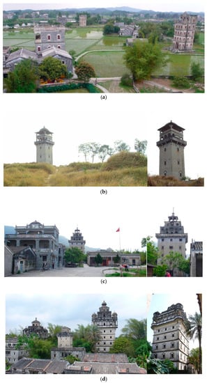
Figure 2.
Images of the Kaiping Diaolou and Villages (KDVs). (a) A full view of KDVs in a heritage site (i.e., the Zili Village); (b) A Genglou (known as Fangshi Denglou) built on a highland between two villages (left) and its near view (right); (c) Zhonglou (named Tianlulou) inside the Majianglong Village (left) and its near view (right); (d) A Julou (known as Ruishilou) and surrounding dwellings in the Jinjiangli Village (left) and its near view (right). Source: all photos are taken by the authors.
The value of KDVs has been widely discussed in literature, including the architectural form, building material, surrounding village landscape, and defensive function. The architecture integrates Chinese and Western architectural art ingeniously, thus forming a distinctive architectural art [37]. The facade of Diaolous consists of three parts, a neat and succinct facade in the lower floors for defense, a hanging terrace in the middle floors with shooting holes, and a top roof [38]. The lower facade, small windows and shooting holes reflect the defensive function, as shown in Figure 2. All buildings are consistently designed, with only a few or no windows on the outer wall protected with a metal fence or plate. The patio or atrium is often small with iron fences. Also, four types of building materials are recognized, such as brick, stone, triad and reinforced concrete [39]. The surrounding village landscape is also designed for defense with reticulated roads and dense house complexes [40]. Diaolous are often located at the back of the village, while the ponds and natural water systems are in the front with bamboo forests in the rear and both sides of village edges [41].
While the defensive functions of Diaolou buildings have been widely recognized and acknowledged as a world cultural heritage by the World Heritage Convention (WHC) since 2007, the spatial organization of Diaolous within and between villages as a defensive system is less discussed in literature and realized in value. In fact, some studies found that the buildings of Julou, Zhonglou and Genglou have different hierarchical defensive missions [42,43,44]. Among them, Julous are mainly built to only defend the residents living in the building; its defensive scope is defined as private defense. Zhonglous have a larger defensive scope for an entire village or several families, often defending all or a part of the residents in the village. Its defensive scope is defined as sub-public defense that not only provides private watch, but also a part of public supervision. Genglous serve as a jointly defensive place for several villages with a much larger defensive scope, providing a warning service for all surrounding villages. Its defensive scope is thus the largest as public defense. Thus, the defensive system of KDVs is consisted of three hierarchies: private defense by Julous, sub-public defense by Zhonglous, and public defense by Genglous.
Without considering the spatial organization of such a defensive system, the OUV of this world heritage would be underestimated. We thus need to re-evaluate the defensive value of Diaolous by the integrity principle, which suggests fully considering the defensive rationale behind the geographical distributions of various types of Diaolous. However, the primary difficulty is how to spatialize the integrity principle by delineating the conservation areas reflecting an intact defensive system. This study aims to solve this problem by a GIS-based quantitative assessment.
4. Methodology
The analytical process mainly comprises of three steps. The first is to delineate the boundary of the defensive region of each Genglou. Here, a defensive region is defined as the basic organizational unit of the defensive function of Diaolous. It is defined as an area under the supervision of at least one Genglou building. As mentioned before, the defensive scope of Genglou could cover several villages, much larger than that of other types of Diaolous, such as Zhonglous and Julous. The second step is to classify the defensive regions by their attributes via principal component analysis and clustering analysis. The third step is to evaluate whether the existing core and buffer areas for preservation delimited by the World Heritage Convention (WCH) fully consider the integrity of the spatial organization of defensive systems, relying on both the typology and boundary of defensive regions.
4.1. Delineating Defensive Regions
Figure 3 shows the calculation process of delineating the areal boundary of defensive regions based on spatial analysis toolkits on the software of ArcGIS 10.4. The first step is to draw the Thiessen polygons of each Genglou in Kaiping to allocate the village space to the nearest Genglou. However, not all the places within a Thiessen polygon can be supervised by the Genglou, because the defensive scope of the Genglou is limited. Thus, in the second step, we need to figure out the largest defensive distance from a Genglou and provide the buffer areas based on the distance. According to the building history of Genglous, a newly-added Genglou often selected a site an “appropriate distance” away from nearby existing Genglous. The “appropriate distance” is identified mainly based on two principles. First, the new Genglou aims to extend the entire defensive scope to the largest extent. Second, there should be an overlap between the defensive scope of the new Genglou and those of other existing Genglous in order to keep all surrounding areas under supervision. Based on these principles, we calculate the linear distance of each Genglou to their nearest neighborhood Genglous in the ArcGIS and visualize them in descending order in Figure 4. After removing the outliers, the maximum nearest neighbor distance is about 3.6 km, so the largest defensive radius of Genglous is set at 1.8 km.

Figure 3.
The analytical process of delineating defensive regions.
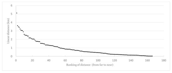
Figure 4.
The distribution of the linear distance of Genglous.
Step 3 overlaps the Thiessen polygons and the supervision buffers of each Genglou to formulate the draft defensive scopes. However, boundaries of some defensive scopes intersect with the boundaries of village patches. This violates the basic rule that Genglous are often built for guarding at least an entire village. To solve this problem, we use the village boundaries to adjust the defensive scope. Because exact village boundaries in history are difficult to recover, we assume that each location only belongs to its closest village. Again, we identify the boundary of villages based on the Thiessen polygon analysis, as shown in the fourth step. We first extract the mass of each village patch, then draw the Thiessen polygon of all masses, representing the village boundary. Next (in the fifth step), we merge the village area delineated in the fourth step and the defensive scopes delineated in the third step to obtain the adjusted defensive scopes. We realize that there are some Genglous that are symmetrically located at two entrances of a village. We call such Genglous as Zhalou. A pair of Zhalous are so close to each other that their defensive scopes are mostly overlapped. Thus, we identify 12 pairs of Zhalou and combine the defensive region of each pair of Zhalous. Also, the borderline influence of rivers on defensive scopes are regarded: if a river passes through a defensive region, the river shoreline is treated as a new boundary to separate the original defensive scope. Finally, the distribution and boundaries of defensive regions are derived and shown in the sixth step of Figure 3. There is a total of 150 defensive regions. The areas covered by the defensive regions are considered as the regions with public-defense function under at least one Genglou’s safeguard, while the remaining areas are defined as non-public defense areas which mainly rely on sub-public defense by Zhonglous, private defense by Julous, or no defense due to the lack of settlements there.
4.2. Clustering Analysis of Defensive Regions
After spatializing the defensive regions, we continued to figure out the typology of defensive regions by their areal and location attributes, including the numbers of Zhonglous and of Julous, the distance of a Genglou to the nearest road, river, and town center and the terrain difference in height, total area, and the density of village plaque. We first identified 40 defensive regions (Type-1) with one or two Genglous within the defensive regions without any Zhonglous and Julous. Further, the remaining 110 defensive regions were clustered by principal component analysis (PCA) and a hierarchical cluster method. Table 1 provides the detailed description of these features, as well as three principle components derived by the PCA in the SPSS software. The PCA results in three principal components are named as F1, F2 and F3, respectively. Among them, F1 is characterized by a relatively small number of Julous and Zhonglous, a moderate area, a small density of village plaque, and a long distance from a road and town; F2 is characterized by a relatively large number of Julous and Zhonglous, a large area, and a large terrain height difference; F3 is characterized by a relatively large number of Julous but relatively small number of Zhonglous, a small area, and relatively close to a road and town. Based on the principal components, the clustering analysis detects three types of defensive regions. By adding the Type-1 defensive regions, we finally categorize the 150 defensive regions into four groups with various specific features.

Table 1.
Areal and location attributes of the defensive regions and three principal components.
5. Results
5.1. Typology of Defensive Regions
Each defensive region may have a defensive system with three hierarchies of functions, including private defense by Julous, sub-public defense by Zhonglous, and public defense by Genglous, as described in detail previously. Based on different defensive functions, the defensive regions are categorized into four types. Figure 5 shows the spatial distribution and geographical boundaries of the four types of defensive regions, based on PCA and clustering analysis. In sum, the area covered by the four types of defensive regions accounts for 55.7% of the total city area. There are 40 Type-1 defensive regions, 57 Type-2, 57 Type-3, and 6 Type-4 regions.

Figure 5.
Distribution and boundary of the four types of defensive regions.
In Type-1 defensive regions, the Genglou is the unique defensive building providing a safeguard function for the entire village area. No other Diaolous (e.g., Zhonglous or Julous) are built to assist the defensive work. Villagers only rely on the Genglou to supervise and resist invasion. Type-1 defensive regions are mainly scattered in underdeveloped villages near the fringe of the city like at the northwest and south areas, and only a small number of Type-1 regions are located near the central plain area. It appears reasonable that underdeveloped villages have limited ability to constructing Zhonglous and Julous while facing lower risks of bandit attack; the presence of Genglous is enough for regular defense against bandits.
Type-2 defensive regions have a relatively smaller area and significant agglomeration in the developed central plains. This implies that Genglous in Type-2 regions are close to each other, providing joint supervision. Type-2 regions also have a relatively small number of Zhonglous and Julous. It may indicate that the joint warning service of Genglous plays a major role in resisting attacks and even without the supplement of other defenses, these Genglous already meet the basic defensive needs of the villagers. Type-3 defensive regions have relatively larger areas, with many Zhonglous and Julous inside. Since a Genglou serving a larger scope would result in a lower efficiency of safeguard, Zhonglous and Julous are thus needed to fill in to provide some sub-public and private defense functions. Type-3 regions are distributed discretely without much agglomeration. It is worth noting that there is no Type-3 defensive region in the poor areas, such as the northeast mountains, because the construction of Zhonglous and Julous requires certain financial support. Type-4 defensive regions have the smallest areas; Genglous provide a safeguard function within a very small area with the highest efficiency. These regions contain a certain number of Zhonglous and Julous, mainly distributed at those villages close to important roads and vulnerable to bandits. There are only six such regions which all distribute discretely in the central plains.
5.2. Evaluating Current Protection Scopes of KDVs Delineated by the WHC
Delineation of current protection scopes and construction control zones of KDVs mainly depends on a Diaolou’s agricultural value. Figure 5 shows four sites of existing preservation scope delineated by the WHC, including Zili Villages, Sanmenli Village, Jinjiangli Village, and the Majianglong Village Cluster, as well as their surrounding buffer areas. We perform a kernel density analysis based on the spatial distribution of the Diaolous with first-class architectural value, which is identified by an official document from the Protection and Management Plan on Kaiping Diaolou and Villages 2001. The document divides Diaolous into five categories by historical significance, architectural art value, and actual state, with the first category recognized as first-class, key buildings for protection. As shown in Figure 6, the Zili Villages area, Jinjiangli Village area and Majianglong Village Cluster area are in the dense areas with high architectural value, and the Sanmenli Village area is delineated mainly to protect the earliest Diaolou, that is, the Yinglonglou Building.
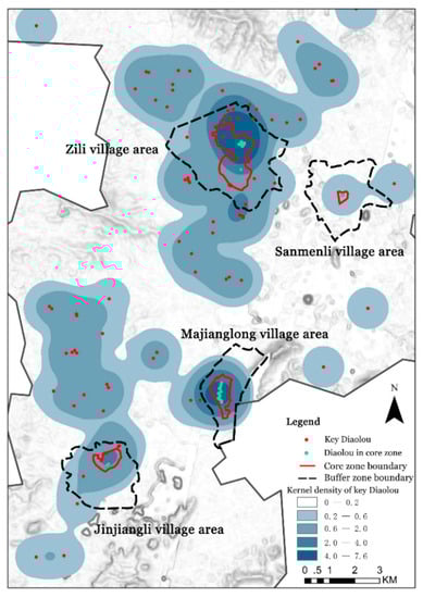
Figure 6.
Existing conservation zones (cores and buffers) and the kernel density distribution of a historical building with first-class architecture value.
In contrast, Figure 7 shows the types of defensive regions defined in the previous section, overlapped with the four existing conservation zones delineated by the WHC. The conservation zone in the Zili village area includes two Type-4 defensive regions; the Sanmenli village area has a Type-2 and a Type-3 defensive region; the Majianglong village area covers two Type-3 regions; the Jinjiangli village area is in the area without any public defense. Therefore, the existing conservation zones neither consider the integrity of the typology of defensive functions, nor scrutinize the integrity of the boundaries of defensive regions. For example, the existing protection scopes do not cover all types of defensive zones; Type-1 defensive regions are not included. Also, the existing conservation zones of Zili Village, Majianglong Village and Jinjiangli Village cut the integral defensive regions into pieces, breaking the rule of intactness.
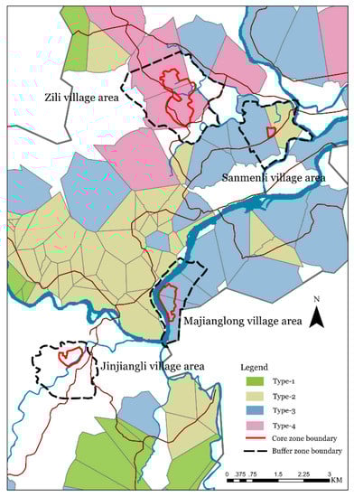
Figure 7.
Existing conservation zones (cores and buffers) and spatial distribution of four types of defensive region.
5.3. Suggestions for Spatializing the Integrity Principle: Typology and Boundary Integrity
There is a more concrete explanation for the integrity principle in the 2017 OGIWHC: “Integrity is a measure of the wholeness and intactness of the natural and/or cultural heritage and its attributes”. This requires that a heritage site includes all necessary elements to express its OUV [45]; not only the material value, but also the intangible, immaterial value of the heritage site should be considered [15]. It is also requested that the protection scopes should be large enough to ensure a full representation of features and processes of the heritage [45]. Village heritages should include both architectural landscapes and village landscapes, in which both intangible and non-material culture are completely reflected. According to these rules from the integrity principle and the findings of the defensive regions in this study, for spatializing the integrity principle, the delineation of protection scopes of the cultural heritage of KDVs should fully consider both typology integrity and boundary integrity.
Typology integrity represents that all types of features associated with the OUV should be protected. In the case of KDVs, the defensive system has at least four types of defensive regions with different defensive architectural landscapes and village configurations. Since the defensive function and system are key elements of the OUV, the protection scope or conservation zones should fully consider the typology integrity by including the four types of defensive regions. Based on the previous analysis, the Type-1 defensive regions are not selected in current protection scopes. In fact, Type-1 regions are a very specific category in the defensive system, with Genglous only and no Zhonglous and Julous. These regions only rely on the public defense by the Genglous, often distributed in the underdeveloped areas without much economic support for private or sub-public defense from other types of Diaolous. They represent quite a different defensive landscape in comparison with other types of defensive regions, with particular cultural value. Therefore, without adding the Type-1 defensive regions into the protection scopes, the OUV is underestimated and the integrity principle is not fully reflected.
On the other hand, boundary integrity implies that the protection scopes of a heritage site should be large enough to include all features that convey the property’s significance. In the case of KDVs, each defensive region is the maximum possible defensive scope of a Genglou, and could be regarded as the basic unit for delineating the protection scopes of the heritage. For meeting the integrity principle, the boundary of the protection scopes and buffer zones should coincide with the boundaries of the defensive regions. Thus, the boundaries of the protection zones of the Zili Village, the Majianglong Village and the Jinjiangli Village should be adjusted according to defensive regions.
6. Conclusions and Discussion
This study explores a GIS-based clustering approach to evaluating the delineation of protection scopes of a world cultural heritage—the Kaiping Diaolou and Villages (KDVs) in south China. We argue that the current protection scopes (four village areas) delimited by the WHC might only scrutinize the architectural value of Diaolous as defensive buildings for resisting bandits and robbers, but overlook the spatial organization of Diaolous within and between villages as a defensive system. Without considering the defensive system, the OUV of this world cultural heritage would be underestimated.
By comparing the current protection scopes of KDVs delineated by the WHC, our findings discover that the existing scopes at least neglect the Type-1 defensive regions, which only rely on the public defense by Genglous and are mostly distributed in underdeveloped areas without much economic support for private or sub-public defense from other types of Diaolous. Also, current boundaries of the protection scopes do not coincide with the boundaries of defensive regions. These two findings suggest that the delineation of protection scopes of KDVs should fully consider the principle of typology and boundary integrity.
These analyses are instructive for identifying the preservation areas of other buildings and landscape heritages around the world. First, a rigorous analytical approach is needed to assess the typology and boundary of potential protection areas. The GIS-based spatial analysis is a promising tool for detecting the ‘rules’ of geographical distribution and organization of building and landscape heritages, as found in previous studies [46,47]. Second, for many existing and potential world cultural heritages, the delineation of protection scopes needs to focus more on the spatial organization, or the functional distribution and organization, of historical buildings, rather than only on their architectural value [15,45,47].
Several limitations remain in this study. First, without much historical data, the boundaries of defensive regions are identified by relying on Thiessen polygon analysis. In the future, we would collect data about village boundaries based on ancient maps and local chronicles, recovering more accurate borders for sustaining boundary integrity. Second, this study mainly focuses on the spatial organization of defensive function since it has been overlooked in past studies. Our future work will combine these spatial-organization and architecture-level defensive features for a better evaluation on typology integrity and element integrity, as well as discussing the protection technology and environmental monitoring system [8] inside and surrounding the Diaolou dwellings, ensuring the delineated protection scopes are technologically feasible and environmentally friendly. Third, more attention should be paid to the non-public defensive areas without the defense of Genglous, but the presence of other types of Diaolous.
Author Contributions
Conceptualization, J.Y. and W.Z.; Data curation, J.Y. and X.L.; Formal analysis, X.T.; Funding acquisition, W.Z.; Investigation, J.Y.; Methodology, J.Y., X.T., W.Z. and J.Z.; Software, X.T.; Writing—original draft, J.Y. and X.T.; Writing—review and editing, W.Z.
Funding
This research was funded by National Key R&D Program of China, grant number: 2018YFD1100304.
Conflicts of Interest
The authors declare no conflict of interest.
References
- Du Plessis, A.A.; Rautenbach, C. Legal perspectives on the role of culture in sustainable development. Potchefstroomse Elektron. Regsblad 2010, 13, 27–71. [Google Scholar]
- Hawkes, J. The Fourth Pillar of Sustainability: Culture’s Essential Role in Public Planning; Common Ground and the Cultural Development Network: Melbourne, Australia, 2001. [Google Scholar]
- Dessein, J.; Soini, K.; Fairclough, G.; Horlings, L. Culture in, for and as Sustainable Development. Conclusions from the COST Action IS1007 Investigating Cultural Sustainability; University of Jyväskylä: Jyväskylä, Finland, 2015. [Google Scholar]
- Loach, K.; Rowley, J.; Griffiths, J. Cultural sustainability as a strategy for the survival of museums and libraries. Int. J. Cult. Policy 2017, 23, 186–198. [Google Scholar] [CrossRef]
- Soini, K.; Birkeland, I. Exploring the scientifc discourse on cultural sustainability. Geoforum 2014, 51, 213–223. [Google Scholar] [CrossRef]
- Chan, W.Y.; Ma, S.Y. Heritage preservation and sustainability of China’s development. Sustain. Dev. 2004, 12, 15–31. [Google Scholar]
- David, T. Linking ecological and cultural sustainability. Divers. Collect. 2008, 8, 15–20. [Google Scholar]
- Lucchi, E. Review of preventive conservation in museum buildings. J. Cult. Herit. 2018, 29, 180–193. [Google Scholar] [CrossRef]
- Kirsten, L.; Jennifer, R.; Jillian, G. Cultural sustainability as a strategy for the survival of museums and libraries. Int. J. Cult. Policy 2017, 23, 186–198. [Google Scholar]
- Vileniske, I. Influence of built heritage on sustainable development of landscape. Landsc. Res. 2008, 33, 425–437. [Google Scholar] [CrossRef]
- UNESCO (United Nations Educational, Scientifc and Cultural Organisation). Introducing Cultural Heritage into the Sustainable Development Agenda 2013. United Nations Educational, Scientific and Cultural Organization. Available online: http://www.unesco.org/new/fleadmin/MULTIMEDIA/HQ/CLT/images/HeritageENG.pdf (accessed on 30 March 2018).
- Zhang, C.Y. A Summary of the research on the authenticity and integrity of world heritage at home and abroad. Southeast Cult. 2010, 4, 30–47. [Google Scholar]
- Gullino, P.; Beccaro, G.L.; Larcher, F. Assessing and Monitoring the Sustainability in Rural World Heritage Sites. Sustainability 2015, 7, 14186–14210. [Google Scholar] [CrossRef]
- World Heritage Committee (WHC). Budapest Declaration on World Heritage 2002. United Nations Educational, Scientific and Cultural Organization. Available online: http://whc.unesco.org/en/decisions/1217/ (accessed on 5 April 2019).
- Du, W.W.; Penabaz-Wiley, S.M.; Njeru, A.M.; Kinoshita, I. Models and Approaches for Integrating Protected Areas with Their Surroundings: A Review of the Literature. Sustainability 2015, 7, 8151–8177. [Google Scholar] [CrossRef]
- Martino, D. Buffer Zones Around Protected Areas: A Brief Literature Review. Electron. Green J. 2001, 1, 1–20. [Google Scholar]
- WHC. Operational Guidelines for the Implementation of the World Heritage Convention 2005. United Nations Educational, Scientific and Cultural Organization. Available online: http://whc.unesco.org/en/guidelines (accessed on 5 April 2019).
- WHC. Nomination of Natural, Mixed and Cultural Properties to the World Heritage List-Kaiping Diaolou and Villages 2007. United Nations Educational, Scientific and Cultural Organization. Available online: https://whc.unesco.org/en/decisions/1323 (accessed on 5 April 2019).
- International Council of Monuments and Sites (ICOMOS). Evaluation Report of Kaiping Diaolou and Villages 2007. United Nations Educational, Scientific and Cultural Organization. Available online: https://whc.unesco.org/en/list/1112/documents/ (accessed on 5 April 2019).
- Xu, G.L.; Situ, S.J. Blending of Chinese and western planning and architectural culture in overseas Chinese in Wuyi, Guangdong. Trop. Geogr. 2005, 1, 87–91. [Google Scholar]
- Scazzosi, L. Reading and assessing the landscape as cultural and historical heritage. Landsc. Res. 2004, 29, 335–355. [Google Scholar] [CrossRef]
- Jukka, J. Considerations on authenticity and integrity in world heritage context. City Time 2006, 2, 1–16. [Google Scholar]
- Chen, Y.H.; Liu, Q. The value system and its protection and utilization of natural and cultural heritage in China. Geogr. Res. 2012, 31, 1111–1120. [Google Scholar]
- Wang, Y.F.; Huang, S.S.; Aise, K.; Jin, K. Toward a framework integrating authenticity and integrity in heritage tourism. J. Sustain. Tour. 2015, 23, 1468–1481. [Google Scholar] [CrossRef]
- Alberts, H.C.; Hazen, H.D. Maintaining authenticity and integrity at cultural world heritage. Am. Geogr. Soc. 2010, 100, 56–73. [Google Scholar] [CrossRef]
- Gullino, P.; Larcher, F. Integrity in UNESCO World Heritage Sites, a comparative study for rural landscapes. J. Cult. Herit. 2013, 14, 389–395. [Google Scholar] [CrossRef]
- Stovel, H. Effective use of authenticity and integrity as world heritage qualifying condition. City Time 2007, 2, 21–36. [Google Scholar]
- Zhang, M.; Han, F. Protection and development of cultural landscape of Dujiangyan water system from the perspective of urban historical landscape. Urban Dev. Stud. 2016, 23, 60–67. [Google Scholar]
- The 2nd International Conference of Architects and Technicians of Historical Monuments. Venice Charter 1964. Available online: https://en.wikipedia.org/wiki/Venice_Charter (accessed on 5 April 2019).
- UNESCO. International Motion on Public or Private Engineering that Jeopardizes the Protection of Cultural Relics; UNESCO: Paris, France, 1968. [Google Scholar]
- WHC. Operational Guidelines for the Implementation of the World Heritage Convention 1977. United Nations Educational, Scientific and Cultural Organization. Available online: http://whc.unesco.org/en/guidelines (accessed on 5 April 2019).
- ICOMOS. The 15th International Council of Monuments and Sites. Xi’an Declaration 2005. Available online: https://www.icomos.org/images/DOCUMENTS/Charters/xian-declaration.pdf (accessed on 5 April 2019).
- International Expert Meeting on World Heritage and Buffer Zones. World Heritage Papers 25—World Heritage and Buffer Zones 2008. United Nations Educational, Scientific and Cultural Organization. Available online: https://whc.unesco.org/en/events/473 (accessed on 5 April 2019).
- Yukio, N. Urban Landscape Planning-European and American Landscape Control Methods and Practice; Shanghai Scientific & Technical Publishers: Shanghai, China, 2005. [Google Scholar]
- Yu, R.; Wu, D.X.; Huang, H.G.; Zhang, Q.H. Kaiping County Records; Hong Kong Folk Voice Press: Hong Kong, China, 1933. [Google Scholar]
- Zhang, G.X.; Li, Y.X. Kaiping Diaolou and Houses; Phoenix Fine Arts Publishing, Ltd.: Nanjing, China, 2002. [Google Scholar]
- Zhu, H. Architectural art characteristics of Kaiping Diaolou. J. Wuyi Univ. (Soc. Sci. Ed.) 2011, 13, 21–23. [Google Scholar]
- Xie, Y.T.; Cheng, J.J.; Wang, P. Comparison of architectural characteristics between Jiangxi Fujian Guangdong Hakkas Enclosure building and Kaiping watchtower. Archit. J. 2015, 13, 113–117. [Google Scholar]
- Cheng, J.J. Diaolou—Chinese-Western Cultural Landscape of Overseas Chinese Villages; China Architecture & Building Press: Beijing, China, 2007. [Google Scholar]
- Huang, J.H.; Zhang, G.X. Kaiping Diaolou and Villages Research; The Chinese Overseas Publishing House: Beijing, China, 2006. [Google Scholar]
- Wu, Z.S. Aesthetic attribute of traditional Hakka houses in east of Guangdong Province. J. Gannan Teach. Coll. 2006, 2, 58–61. [Google Scholar]
- Liu, P.L. Ancient Chinese village planning ideas. Stud. Hist. Nat. Sci. 1998, 17, 82–90. [Google Scholar]
- Yang, B. Research on characteristics of space organization of Kaiping Diaolou and Village in World Cultural Heritage. Spec. Zone Econ. 2013, 6, 218–219. [Google Scholar]
- Li, X.Z.; Ren, J. Comparison of regional traditional fortress settlements defensive. Archit. Cult. 2014, 4, 92–94. [Google Scholar]
- WHC. Operational Guidelines for the Implementation of the World Heritage Convention 2017. United Nations Educational, Scientific and Cultural Organization. Available online: http://whc.unesco.org/en/guidelines (accessed on 5 April 2019).
- Zhu, M.; Dong, J.F.; Gao, Y.Z. The Research on Temporal-Spatial Distribution and Morphological Characteristics of Ancient Settlements in the Songhua River Basin. Sustainability 2019, 11, 932. [Google Scholar] [CrossRef]
- Liang, X.F.; Yin, J.; Yang, B.; Song, Z. The spatial-temporal evolution of Kaiping Diaolou and Villages’ defensive functional pattern. Geogr. Res. 2017, 36, 121–133. [Google Scholar]
© 2019 by the authors. Licensee MDPI, Basel, Switzerland. This article is an open access article distributed under the terms and conditions of the Creative Commons Attribution (CC BY) license (http://creativecommons.org/licenses/by/4.0/).