Abstract
Shallow geothermal energy (SGE), as an important renewable energy, playing an important role in reducing carbon emissions. In order to efficiently and sustainably utilize SGE, field investigation and storage estimation are needed. In this study, the hydrogeological data obtained from the field exploration of Jinan Start-up Area were collected and compiled. By analyzing the geotechnical property data and thermal response test results, the information of geotechnical and thermal properties and underground temperature distribution characteristics were collected. Subsequently, the analytic hierarchy process (AHP) combined with the comprehensive index method (CIM) were used to classify the shallow geothermal potential of Jinan Start-up Area. The entire area was divided into a high-potential area, medium-potential area and general area, of which 92.2% was high-potential area. The preliminary results, combined with the parameters obtained from the testing, indicate that the SGE storage at a borehole depth of 120 m is estimated to be approximately 2.68 × 10¹² kJ·K−1, while the heat exchanger power of the buried pipe at the same depth is calculated to be around 1.73 × 10⁵ kW. Finally, suggestions are given for sustainable development and utilization of SGE in this area.
1. Introduction
The building sector in China accounted for 45.5% of the total national energy consumption, with a significant energy consumption of 2.27 billion tons of standard coal equivalent by 2020 [1]. More than half of the building energy consumption is taken up by cooling and heating [2]. To implement the goal of energy saving and carbon emission reduction, ground source heat pump (GSHP) systems, which mainly use SGE, were developed to replace traditional fossil fuels like coal. As a kind of renewable energy with wide application, convenient exploration, low cost and lack of pollution, SGE has the characteristics of wide distribution, large storage capacity and high stability. Moreover, geothermal energy can be continuously developed and utilized without being affected by weather conditions [3]. At present, GSHP technology is the main way to develop and exploit SGE for cooling and heating. Moreover, it also has potential applications in health care, tourism, aquaculture, irrigation and other fields [4].
While many countries and regions are vigorously promoting the application of SGE, there are instances where some projects were conducted without preliminary geological investigations of the geothermal extraction areas. There is often a lack of clear understanding of the thermal and hydrogeological conditions in the region, and inadequate regional exploitation planning is implemented. As a result, there are cases of irrational utilization and wastage of shallow geothermal resources.
The spatial variability of thermal and hydrogeological conditions is a critical factor in assessing the exploitable potential of geothermal exploration areas [5]. A method called G.POT, which is based on GIS and considers the groundwater content of the subsurface environment, was developed by Ramos et al. [6] to assess geothermal resources in the Murcia region of Spain. Geothermal resources in Europe were assessed by Galgaro et al. [7]. In their study, factors such as drilling techniques, drilling time, geological background and installation costs were comprehensively considered, and a drillability map was generated. Coro et al. [8] reported a method of processing geospatial data related to geothermal site suitability and geothermal power plant operation using a maximum entropy model and generated a suitability map of potential geothermal sites at a global scale. A data-driven algorithm based on the entropy weight method and the technique for order of preference by similarity to ideal solution was proposed by Li et al. [9] for assessing the implementation potential of shallow geothermal energy in a region. They implemented this algorithm using Matlab and applied it to the city of Nantong, China. To address the decarbonization of energy and develop low-carbon energy sources, Alimonti et al. [10] investigated the feasibility of repurposing oil and gas fields in Italy for geothermal energy production. They utilized numerical models based on thermodynamics and heat conduction to assess geothermal resources, extractable reserves and economic viability, offering practical solutions for energy transition.
In order to implement the policy of high-quality development in Jinan Start-up Area, the Jinan municipal government has proposed a concept of extensively developing and utilizing the resources of the Yellow River Basin. This includes the establishment of the Jinan Start-up Area, aimed at promoting the integration of the Yellow River, which runs through the city, into the new development pattern of the provincial capital. The planning area of the Jinan Start-up Area is about 800 km2, located in the north of Jinan on both sides of the Yellow River, north of the Qihe-Guangrao fracture. Its thermal reservoir is buried at a suitable depth and has good conditions for storing SGE. Reasonable planning of SGE can provide a reference for the sustainable development of the Jinan Start-up Area. Therefore, in this study, a thorough field investigation was conducted and the hydrogeological data were collected and processed for the target area. The information of geotechnical and thermal properties and underground temperature distribution was obtained. Subsequently, the AHP and CIM were used to classify the shallow geothermal potential, with the entire area divided into a high-potential area, medium-potential area and general area. Based on the results, suggestions are given for sustainable development and utilization of SGE in this area.
2. Materials and Methods
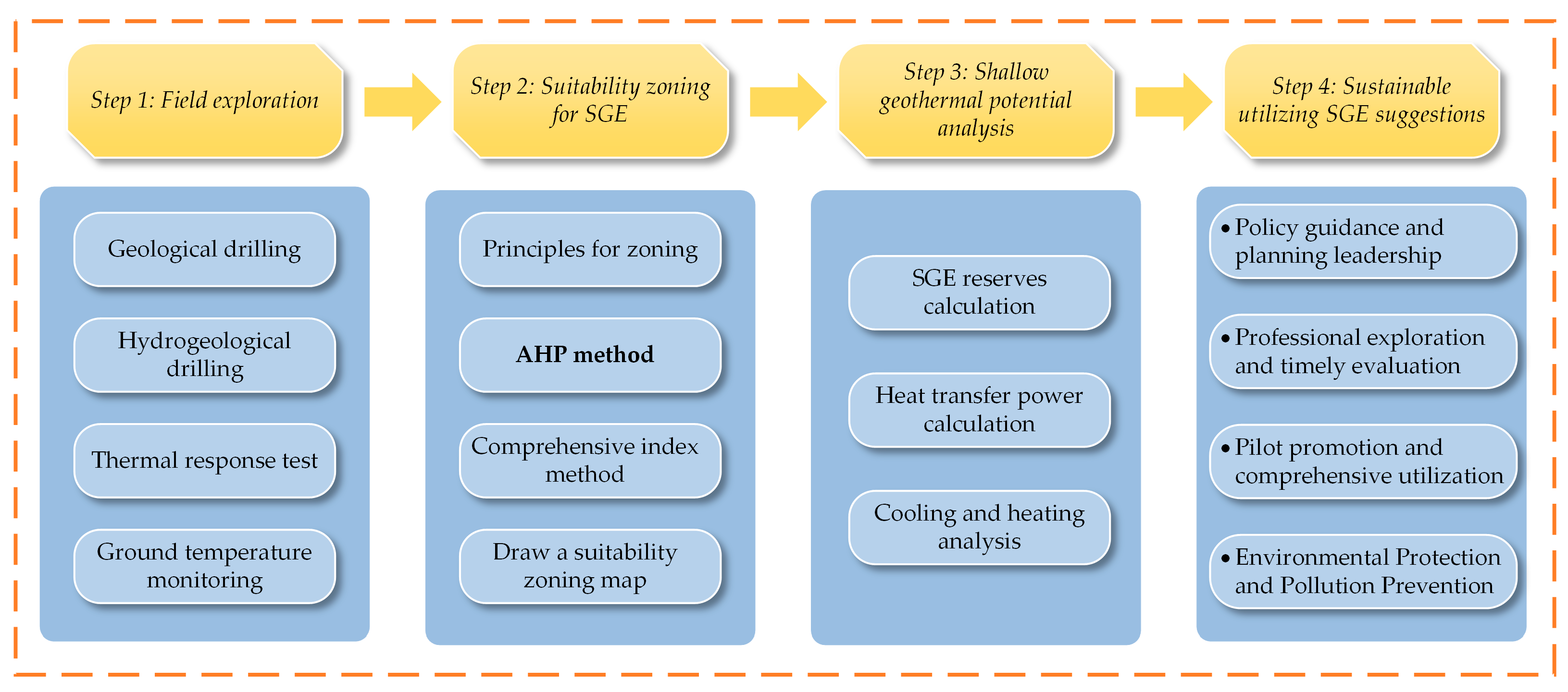
The research work is divided into four steps according to the identified problem and the chosen methodology. The workflow is illustrated in Figure 1.
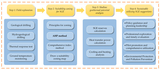
Figure 1.
SGE research workflow.
Step 1 involves conducting field geological exploration in the study area to obtain information on the Quaternary thickness and groundwater depth. Thermal response tests provide data on soil thermal conductivity, average specific heat capacity and soil temperature. Ground temperature monitoring yields the characteristic distribution of the geothermal field. In Step 2, the collected parameters are organized and processed. The AHP is used to calculate and assign weights to various factors, facilitating the suitability zoning of Jinan Start-up Area. The preliminary zoning result map of the SGE suitability in the study area is generated using ArcGIS 10.7. Step 3 encompasses the calculation of energy storage and heat transfer power for SGE in the study area, followed by an analysis of the potential for cooling and heating in Jinan Start-up Area. Lastly, Step 4 presents sustainable development recommendations for the application of shallow geothermal energy in Jinan Start-up Area, focusing on four aspects.
2.1. Field Exploration
In order to ascertain the geological characteristics of the shallow layers, it was necessary to carry out drilling projects. A total depth of 3168.0 m was drilled, comprising 2966.8 m of geological boreholes and 201.2 m of hydrological boreholes.
2.1.1. Geological Drilling
During the drilling process, a rotary drilling rig was employed. There are in total 24 boreholes, each designed to reach a depth of 120 m. The initial drilling diameter of boreholes is 108 mm and continuous core samples were obtained to facilitate real-time lithological recording. Physical and thermal property test samples were collected, and afterwards, the borehole was expanded to the bottom using a 150 mm drill bit. After completion of the core drilling, on-site hydraulic testing was conducted to ensure the integrity of the U-tube, followed by the backfilling of the borehole with sand to prepare for the on-site thermal response test.
2.1.2. Hydrogeological Drilling
Three hydrological boreholes were drilled, with two designed to reach a depth of 60 m and one designed to reach a depth of 80 m. The boreholes were initially drilled with a diameter of 500 mm and continued to a depth of 2 m before reducing to a diameter of 330 mm for the rest of the drilling to reach the bottom. Subsequently, 273 mm seamless steel pipes and filter pipes were installed, and the space between the steel pipes and the borehole wall was filled with coarse sand [11]. Finally, the borehole was sealed at the surface using clay balls.
2.1.3. Thermal Response Test
The thermal response tests provided reliable reference data for the design of the GSHP system [12]. The shallow soil thermal response dynamic experimental platform mainly consists of a thermostatic heater, thermostatic water tank, heat pump, circulation system and temperature flow monitoring and control system. Without activating the cooling and heating devices, the circulation pump is operated until the temperatures at various measurement points reach a relatively consistent level. Each experiment lasts for a minimum of 24 h. The circulating fluid’s average temperature in the ground portion, achieved during the non-reactive circulation, is considered as the initial temperature of the rock and soil [13]. Subsequently, the circulating medium in the loop is heated with a power of 6 kW during each testing period, which lasts for no less than 48 h.
2.1.4. Ground Temperature Monitoring
In the case of unbalanced cooling and heating loads, the extensive and long-term application of borehole heat exchangers (BHEs) can alter the distribution of underground temperature fields, thereby affecting the operational performance of GSHP [14]. Geothermal monitoring facilitates the assessment of the performance and effectiveness of the GSHP system [15]. By analyzing the geothermal monitoring data, it is possible to gain insights into the operational status and efficiency of the GSHP system, promptly detect issues and anomalies and implement appropriate measures for maintenance and adjustments. Therefore, temperature monitoring of the underground environment is necessary. In this study, four geological boreholes were selected for dynamic temperature monitoring, resulting in a total of 384 observation points. Temperature measurements were performed using STI-AS temperature data loggers.
2.2. Suitability Zoning Based on AHP
2.2.1. Principles for Zoning
Geological conditions need to be considered first and foremost. The geological conditions serve as the fundamental basis for the formation of SGE and significantly influence its development and utilization. Therefore, the geological conditions are considered as the primary factor in the study.
Hydrogeological conditions of the study area are crucial. The presence of groundwater, including its distribution, hydraulic conditions and underground water flow characteristics, also has a significant impact on the development and utilization of SGE. The groundwater flow contributes to enhancing heat exchange efficiency [16].
The development of the study area necessitates the utilization of heat pump technology. Currently, the main approach for the development and utilization of SGE in the region is through the implementation of a BHE system. The characteristics and limitations of this technology also impose certain restrictions on the development and utilization of SGE.
The principle of integrating economic benefits and environmental benefits should be followed in the development process. Due to Jinan’s renowned springs, the protection of underground water resources is of utmost importance. Therefore, the development and utilization of SGE in the study area should carefully consider the potential impact on urban groundwater pollution [17]. Furthermore, the chosen development plan should align with the administrative planning of Jinan Start-up Area, prioritizing both economic benefits and environmental preservation.
2.2.2. AHP Method
The AHP method allows for comprehensive consideration of multiple criteria and their respective weights, quantifying empirical judgments and providing a holistic assessment of the merits and drawbacks of various options. It offers well-founded decision outcomes to address complex problems that are difficult to analyze by other means [18]. The specific steps are as follows:
- Establishing the hierarchical structure of the evaluation system.
Clearly define the problem to be addressed and establish the target layer. Based on the characteristics of the target layer, decompose it into multiple attribute layers. Subsequently, identify the factor layers influencing these attributes, ensuring that each level maintains relative independence and comparability.
- Constructing a judgment matrix.
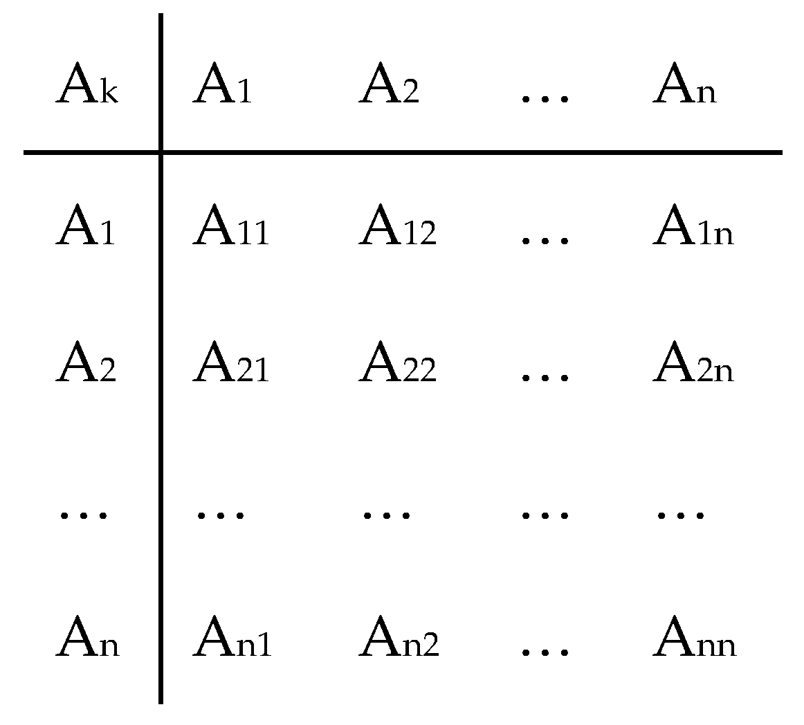
In order to compare the importance of each pair of attribute layers, judgment matrices are constructed. Similarly, for each pair of factor layers within each attribute layer, additional judgment matrices are established to assess their relative significance. Assuming a given attribute layer to be Ak, A1, A2, …, An are all influencing factors of Ak. It is necessary to compare the relative importance of A1, A2, …, An with respect to Ak. The use of a 1–9 scale allows representation of the importance of each factor concerning the attribute layer, as shown in Table 1. Higher values in the judgment matrix indicate greater importance of the corresponding element within the attribute layer. After determining the scales for each element, a judgment matrix is constructed in the form depicted in Figure 2.

Table 1.
Scale of judgment matrices.
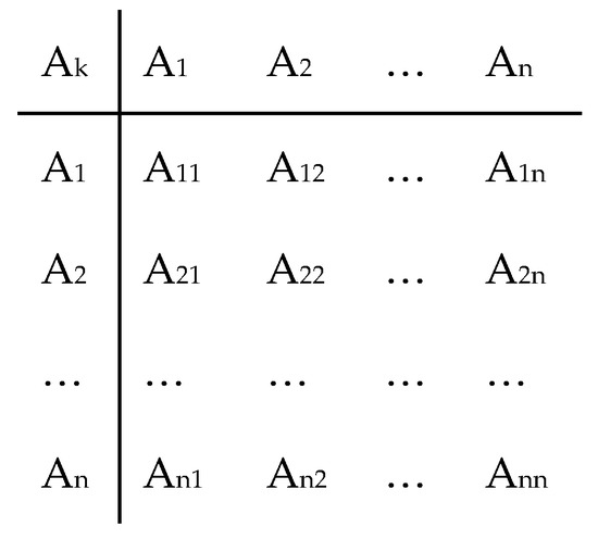
Figure 2.
Judgment matrix.
- Compute the weights and the maximum eigenvalue for each judgment matrix.
The weights of the judgment matrices can be determined through the utilization of Formula (1). The normalization is performed on each column of the judgment matrices [19], and the resulting matrices are aggregated by summing the rows. Finally, the resulting columns are normalized to obtain the weights.
where aij represents the relative comparison values of various factors in the judgment matrix, aii = ajj = 1, aij = 1/aji, n is the number of factors, w is the weight, λmax represents the maximum eigenvalue of the matrix, Aw is the eigenvector.
- Verify the consistency of the matrices.
The consistency index (CI) represents the variance of errors generated during estimation. A smaller CI indicates a stronger tendency towards consistency in the matrix [20], whereas a higher value indicates greater deviation from consistency.
If CI ≠ 0, the average random consistency index (RI) is introduced and compared with CI. The RI is dependent on the order of the matrix, and as the order increases, the probability of deviation from average random consistency also increases [21]. The RI for orders 1 to 9 are shown in Table 2.

Table 2.
Random consistency index for matrices of different orders.
When the order of the comparison matrix is higher than two, the random consistency ratio (CR) is introduced. When CR < 0.1, it can be statistically considered that the comparison matrix is consistent. Otherwise, the assignment in the comparison matrix needs to be adjusted and re-run until CR < 0.1. At this point, the weights of each element obtained will meet the requirements of the AHP.
2.2.3. Comprehensive Index Method
The comprehensive evaluation of the shallow geothermal potential in the study area is conducted using the CIM. The comprehensive index method is a statistical approach that entails processing a set of similar or dissimilar indicator values, standardizing and consolidating them into a comprehensive index to precisely assess the overall level of work performance [22]. This method facilitates a comprehensive comparison of indicators with diverse measurement units and characteristics, thereby yielding a comprehensive evaluation of work performance. Through statistical processing, the assigned values of each attribute at each grid point are multiplied by their corresponding weights and then summed up, resulting in the preliminary score for each grid point.
2.3. Shallow Geothermal Potential Analysis
2.3.1. Calculation of SGE Reserves
The volumetric method allows for the separate calculation of unit temperature difference storage in both the unsaturated zone and the saturated zone and then determination of the thermal storage performance of the geological formation in the research area. It is a relatively accurate method compared to the geothermal flux method and thermal conductivity method. Referring to the method proposed by Hu [23] utilizing the volumetric method to calculate the shallow geothermal capacity, the formula can be expressed as follows:
where QR is shallow geothermal capacity (kJ·K−1), QS is heat capacity in rock and soil (kJ·K−1), QW is heat capacity in water contained in rock and soil (kJ·K−1), is soil and rock density (kg·m−3), CS is specific heat capacity of soil and rock (kJ·kg−1·K−1), is porosity of soil and rock, M is calculated area (m2), is density of water (kg·m−3), CW is specific heat capacity of water (kJ·kg−1·K−1), d is thickness of the geological formation from the water table to the lower limit of calculation (m).
2.3.2. Calculation of Heat Transfer Power
The heat transfer coefficient of the BHE was determined through on-site thermal response testing. In regions with similar or comparable shallow geothermal conditions, the borehole heat transfer power and SGE can be calculated by multiplying the single borehole heat transfer power by the effective utilization of the area.
where D is heat transfer power of the BHE (W), KS is heat transfer coefficient of the BHE (W·m−1·K−1), L is length of the BHE (m), t1 is average temperature of the fluid inside the BHE (°C), t2 is temperature of the surrounding soil and rock beyond the influence radius (°C), Qh is regional heat transfer power (kW), n is the number of BHEs within the calculated region.
2.3.3. Cooling and Heating Potential Analysis
By dividing the heat transfer power of the BHE by the heating and cooling load indicators, the heating and cooling area (M) available in the study area is obtained. Subsequently, M is divided by the total area of the study region to calculate the unit area heating and cooling potential (UAP) for different suitability zones. The UAP of a region plays a crucial role in determining the feasibility and sustainability of GSHP system utilization. In high-potential areas for SGE, GSHP systems represent an environmentally friendly and efficient technology for cooling and heating, effectively harnessing geothermal resources from underground. However, in general areas that are only moderately suitable, the available SGE for GSHPs is relatively limited, resulting in lower economic and sustainable benefits.
3. Study Case
3.1. Geographic Conditions
The geographical coordinates of the Jinan Start-up Area are approximately between 36°40′ N to 37°07′ N latitude and 116°48′ E to 117°20′ E longitude. It is characterized by a temperate monsoon climate, with an annual precipitation of about 669 mm. The rainfall is concentrated in July and August. This area, from south to north, encompasses four different landforms: tectonic erosion hills of low- to mid-range elevation, erosion and dissolution hills of low- to mid-range elevation, mountain-front alluvial and floodplain landscapes and the Yellow River alluvial plain. Situated within the expansive Yellow River alluvial plain, the area is characterized by a predominantly flat terrain shaped by the hydrological influence of rivers such as the Yellow River and Xiaoqing River. The ground elevation varies from 15 to 197 m, with higher elevations in the southern region and lower elevations in the northern part. In the southern part of the region, there are several mountains including Huashan, Yaoshan, Woniu Mountain and Nan Woniu Mountain. Among them, Huashan is the highest peak with a ground elevation of 197.0 m.
The rock formations in the region can be classified into two types: hard blocky metamorphic rocks and hard to moderately hard and thick-layered carbonate rocks. The first type consists primarily of Tai Shan Group gneiss, granulite and slate, which are prone to weathering. The second type includes mainly limestone, dolomitic limestone and shale from the Middle Ordovician to Middle Cambrian Zhangxia Formation. The mountain-front plain is characterized by deposits of Quaternary and upper Pleistocene impact and flood sediments, while the northern floodplain is widely covered by deposits of Quaternary impact layers. Based on their structural characteristics, they can be further classified into the northern floodplain impact layers and the northern mountain-front plain fluvial and flood deposits. The dominant soil structure type in the northern region is clay, while the upper layers of the soil in the northern mountain-front plain fluvial and flood deposits consist mainly of multi-layered cohesive soil structures.
3.2. Hydrogeology Conditions
The Jinan Start-up Area is a part of the Yellow River alluvial plain, with loose lithology, fine particles and strong water-richness. The sand layer is mostly banded and enriched, with good conditions for the formation of water storage space. According to the characteristics of the water-bearing medium and the law of groundwater distribution and transportation in the water-bearing medium, the groundwater in the region is divided into three categories: loose rock pore water, interbedded tuff karst fracture water and carbonate fracture karst water. Groundwater recharge is mainly derived from the infiltration of atmospheric precipitation. In the area along the Yellow River, the replenishment of groundwater through the lateral seepage of Yellow River water is still acceptable.
The shallow confined aquifer refers to the groundwater within a depth of 60 m. In the Ertaiping-Duoshi area of the central and western regions, the aquifer consists of fine sand, silt and medium sand, with a thickness ranging from 13 to 19 m. The single-well yield can exceed 60 m3·h−1. In the Huaihe Town–Cuizhai area in the southwest of Jiyang County, the water level is shallow, ranging from 3 to 5 m, with an annual fluctuation of less than 2 m. It exhibits strong water richness, with a single well yielding 1000 to 1500 m3·d−1. This region represents the occurrence of SGE resources. The intermediate confined aquifer refers to the groundwater at a depth of 60 to 200 m, primarily composed of fine sand and silt. Multiple layers of thick and continuously distributed sandy clay aquitards are present.
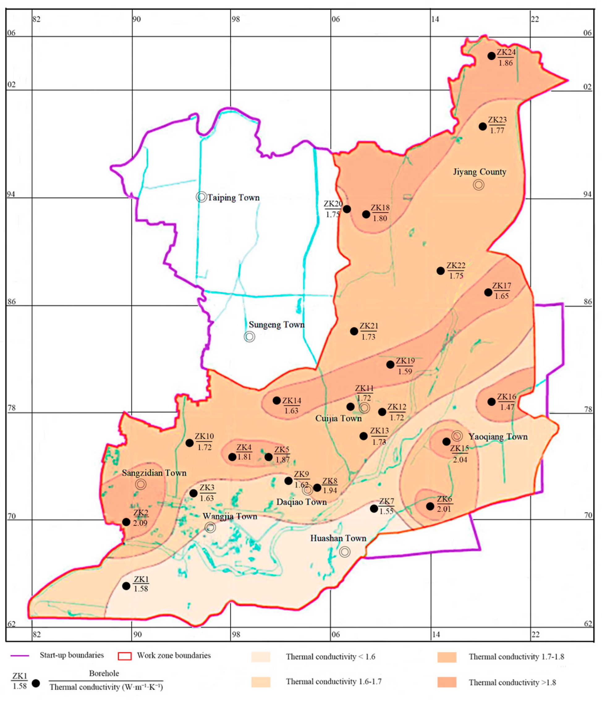
3.3. Geothermal Field Characteristics
Based on the test data, the distribution of thermal conductivity for the 24 monitoring boreholes in the research area can be obtained (Figure 3). It was found that the thermal conductivity of the rock and soil ranged from 1.47 to 2.10 W·m−1·K−1. Below a depth of 15 m, the monitoring points at various depths show consistent temperatures, unaffected by surface environmental disturbances. The average temperature at this depth is recorded as 16.44 °C, with a slight upward trend along the depth gradient. At the depth of 120 m, the average geothermal gradient varies from 2.18 to 4.80 °C per 100 m. The average specific heat capacity of the rock and soil formation is 0.95 kJ·kg−1·K−1. Owing to historical reasons, at the initiation of the data survey, neither Taiping Town nor Sungeng Town were included within the Start-up area. Consequently, there no drillings or TRT tests conducted in these two towns. If an opportunity arises in the future, a renewed investigation will be conducted to assess and supplement the geothermal resources in these regions.
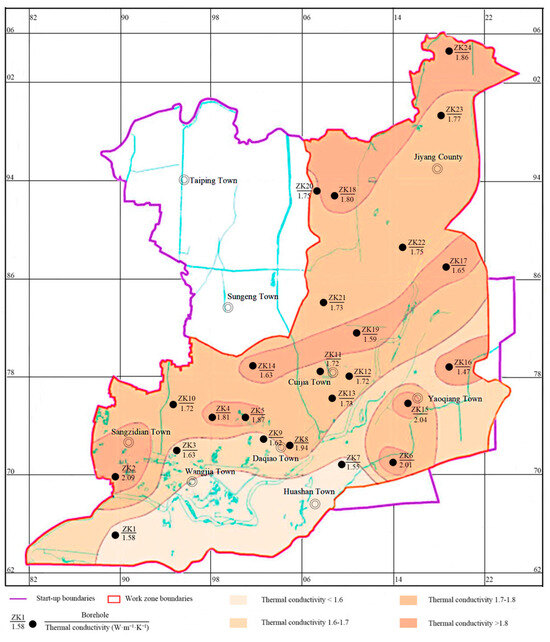
Figure 3.
Distribution of thermal conductivity in the geological formations of Jinan Start-up Area.
4. Results
4.1. Suitability Zoning for SGE in Jinan Start-Up Area
The hierarchical relationship of the evaluation system is established using the AHP, comprising three attribute layers and seven factor layers. The development and utilization of SGE in Jinan Start-up Area mainly focus on the BHE system. Therefore, the objective layer of this model is the suitability zoning for the development and utilization of SGE using GSHPs in Jinan Start-up Area. The attribute layers represent the major influencing factors of the objective layer. For this study, the attribute layers are set as follows: geological and hydrogeological conditions (A), construction conditions (B) and thermal and physical properties of the geological formations (C). The following factors are considered as element layers: thickness of the Quaternary system (A1), depth of groundwater table (A2), drilling conditions (B1), urban coverage rate (B2), thermal conductivity (C1), specific heat capacity (C2) and geothermal gradient (C3) [24] The Jinan Start-up Area has a relatively flat terrain, and the hydraulic gradient of groundwater is small. The influence of groundwater runoff on the buried pipe GSHP is not considered at present. Based on the above settings, a hierarchical structure model is established for the suitability assessment of SGE development and utilization using GSHPs in Jinan Start-up Area as shown in Figure 4.

Figure 4.
Hierarchical structure model for suitability classification.
According to the weight calculation formula in the AHP method, taking the thermal physical properties of geological layers (C) weighting calculation as an example, a judgment matrix is established for thermal conductivity (C1), specific heat capacity (C2) and geothermal gradient (C3).
- (1)
- Weight calculation
- (2)
- Eigenvector calculation
- (3)
- Maximum eigenvalue calculation
- (4)
- Consistency verification
The judgment matrix exhibits consistency and does not require scale adjustments [25]. The judgment matrices and weight results for the attribute layers and factor layers can be found in Table 3, Table 4, Table 5, Table 6 and Table 7.

Table 3.
Weight factors for suitability zoning conditions.

Table 4.
Weight factors for geological and hydrogeological conditions.

Table 5.
Weight factors for construction conditions.

Table 6.
Weight factors for thermal physical properties of geological layers.

Table 7.
Effective weights of each factor.
Building upon the approach introduced by Tinti [26], a value ranging from 1 to 9 is assigned to each element within the layer, reflecting its classification. A higher numerical score corresponds to a higher level of potential for SGE. For example, elements with higher thermal conductivity receive higher scores. Assigning values to the elements in each region based on their respective classifications and considering the corresponding weights assigned to each element, it becomes possible to calculate the total score for each region. These scores can then be utilized to conduct suitability zoning, facilitating the identification of appropriate zones with significant potential for SGE. A detailed account of the outcomes can be found in Table 8.

Table 8.
Assigning gradation values to each element.
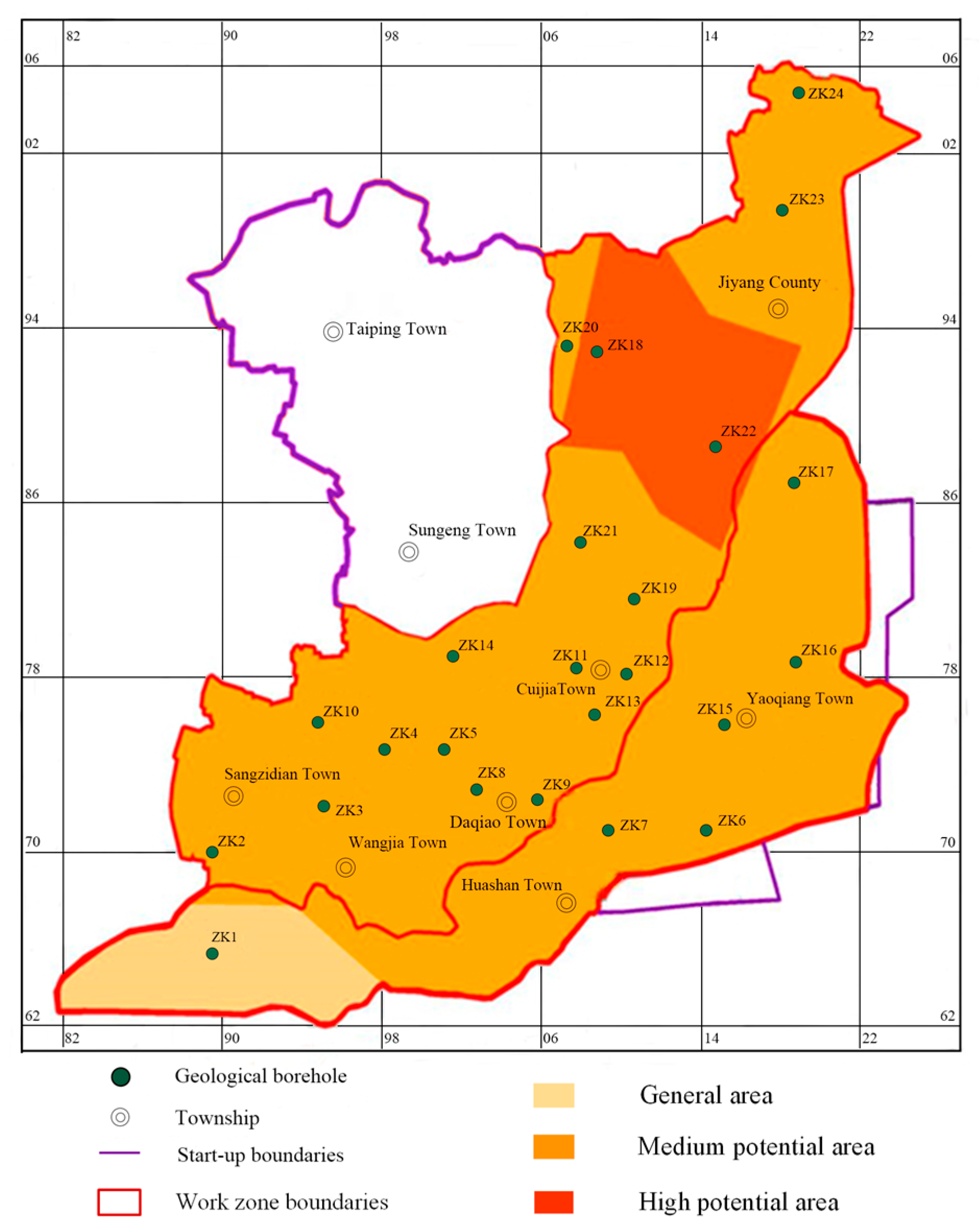
The regions with scores ranging from 2 to 4 are classified as general area, those with scores from 4 to 6 are classified as medium-potential area and regions with scores higher than 6 are classified as high-potential area [27]. The suitability zoning results were visualized using ArcGIS 10.7, as shown in Figure 5. The red zone represents the high-potential area for the application of GSHP systems, primarily located near Lijia Village in Jiyang County and Xinzhuang in Jibei Sub-district. These areas have a total area of 43.22 km2, accounting for 5.4% of the Jinan Start-up Area. This region features a flat topography with loose lithology, abundant sand layers arranged in a banded distribution and a strong presence of groundwater with high water yield from individual wells, indicating a rich geothermal resource. The orange zone represents the medium potential area for the application of GSHP systems, with a total area of 737.65 km2, accounting for 92.2% of the Jinan Start-up Area. The yellow zone represents the general areas for the application of GSHP systems, which have a smaller coverage and are mainly located near Meili Village in Huiyin District. These areas have a total area of 19.22 km2, accounting for 2.4% of the Jinan Start-up Area.
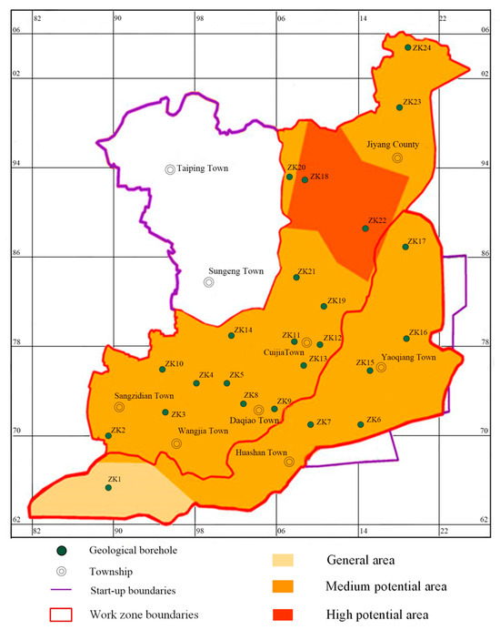
Figure 5.
Suitability Zoning for SGE.
4.2. Calculation and Analysis of SGE Reserves in Jinan Start-Up Area
Summing up the heat capacities calculated for each drilling location, the SGE storage capacity at a drilling depth of 120 m in the Jinan Start-up Area is estimated to be 2.68 × 10¹² kJ·K−1, which is about 43,147 tons of standard coal. The heat capacity per unit area of the study area is 3.35 × 10⁹ kJ·K−1⋅km−2.
The BHE exhibits an average heat transfer coefficient of 2.5 W·m−1·K−1, while the temperature difference between the circulating fluid and the soil for heat exchange is set with a minimum value of 5 °C and a maximum value of 15 °C. In light of the existing construction status in Jinan Start-up Area, a comprehensive land utilization rate of 60% has been considered. Additionally, the coefficients for the integrated green space area ratio and the GSHP utilization rate are taken as 20%, leading to a land utilization rate of 12% for the region. The spacing between the BHEs is 5 m. Upon substituting all parameter values into Equations (7) and (8), the heat transfer power per single borehole is calculated as 4.5 kW, and the corresponding regional heat transfer power is presented in Table 9.

Table 9.
Geological parameters and SGE reserves calculation results.
Based on the thermal load indicators for energy-efficient residential buildings in Jinan, with a heating load index of 40 W·m−2 and a cooling load index of 60 W·m−2, the calculation of the regional heat transfer power enables the assessment of the cooling and heating potential in the study area. The calculated heating area is 4.32 × 10⁶ m2, and the cooling area is 2.88 × 10⁶ m2. Unit-area shallow geothermal potential is obtained by dividing the total heating and cooling area by the effective utilized area of the planned zone. The available area for heating in winter is around 4.5 × 10⁴ m2·km−2, and cooling in summer is about 3.0 × 10⁴ m2·km−2. Through comparison, it is found that the winter per unit area shallow geothermal potential is greater than that of summer, and it is 1.5 times that of summer.
4.3. Suggestions for Sustainably Utilizing SGE
4.3.1. SGE Applications in Jinan Start-Up Area
The development direction of SGE in Jinan Start-up Area should be aligned with the administrative planning. The distribution of SGE resources, their occurrence conditions and economic benefits should be thoroughly considered, while attention should be paid to conserving resources and protecting the geological environment. Moreover, for newly constructed buildings with suitable geothermal conditions, the utilization of GSHPs for harnessing SGE should be promoted. In the process of geothermal exploitation, issues such as uneven soil temperature distribution [28] and groundwater pollution [29] may arise. To minimize the adverse impacts of large-scale geothermal development on the environment and human health, the use of heat extraction technologies based on high-performance BHE and closed-loop systems should be promoted [30].
- High-potential area
The high-potential areas are distributed near Lijia Village in Jiyang County and Xinzhuang Sub-district of Jibei District. The target area is characterized by a loose rock formation with a porous aquifer, which exhibits good water-bearing properties, making it rich in SGE reserves. Currently, there are no residential buildings, shopping centers or office buildings in this region, and the land utilization rate is relatively low. However, its proximity to the northern urban area of Jiyang County presents significant development potential and promising prospects for the utilization of GSHPs. Furthermore, to further explore the potential of SGE in this area, it is recommended to increase the density of boreholes, study the occurrence conditions of SGE and fully leverage the geothermal conditions.
- Medium-potential area
Most areas in Jinan Start-up Area are considered medium-potential areas. These areas are primarily characterized by porous aquifers within loose rock formations, with variations in water-bearing properties. The northern part of the Yellow River exhibits better water-bearing characteristics compared to the southern part. Based on a borehole diameter of 219 mm, estimated well yields range from 500 to 3000 m3·d−1 for a 5 m drawdown depth, demonstrating significant variations. Currently, the development level is relatively high in the Jiyang urban area and the vicinity of Daqiao Town, while other areas have lower land utilization rates. The region encompasses the future priority development zone, including the urban center, and holds immense potential for the utilization of SGE. It is strategically positioned as the site for the construction of an ecological green axis, an integrated demonstration area for the harmonious coexistence of industry and cities and an economic zone with aerospace-related industries. Additionally, considering that the geothermal conditions in this area are slightly inferior to the high-potential areas, alternative approaches coupling other renewable energy sources may be considered to supplement the independent heating and cooling requirements of SGE systems.
4.3.2. SGE Sustainable Development and Utilization
- Policy guidance and planning leadership.
Policy serves as a major driving force for promoting the development of various endeavors. The overall initial investment in GSHP systems is substantial but, without sufficient promotional efforts, their widespread adoption will be challenging. Consequently, it is imperative for the government to implement subsidy policies. Long-term planning plays a crucial role in charting the course of industry development for the future. Presently, China has already introduced the “14th Five-Year Plan for the Modern Energy System” and the “13th Five-Year Plan for Geothermal Energy Development and Utilization”, providing a scientifically sound planning blueprint that addresses the gaps in standardization and strategic planning for geothermal energy. This blueprint contributes to enhancing the economic benefits of the geothermal industry and proactively guides the future development and utilization of shallow geothermal energy in China.
- Professional exploration and timely evaluation.
Most of the exploration work for SGE in China relies on geological mining, and there are fewer specialized commercial exploration teams. The technical procedures of these commercial teams also suffer from non-compliance issues, leading to unreliable exploration results. Therefore, it is essential to provide systematic training for exploration teams to promote a new standardized norm in the exploration process. After obtaining first-hand exploration data, there is a certain lag in suitability zoning and comprehensive evaluation by the exploration teams, which can impact the development progress of shallow geothermal energy. Therefore, timely evaluation of exploration data is essential to facilitate the rational planning of regional energy utilization.
- Pilot promotion and comprehensive utilization.
The development and utilization of regional SGE in China have primarily focused on heating, hot springs and agricultural applications, leading to a relatively limited level of comprehensive utilization. In the future, upon ascertaining the geological conditions conducive to SGE in a given area, appropriate regions can be selected for piloting novel technologies to achieve cascaded utilization of shallow geothermal energy and assess its effectiveness. In cases where the conditions for regional SGE are unfavorable, alternative pilot studies can be conducted, coupling SGE with other renewable resources, thereby genuinely realizing the integrated utilization of energy resources.
- Environmental protection and pollution prevention.
An alarming issue [31] pertains to the improper installation of GSHP systems in contaminated sites, which may result in the migration of pollutants from the surface to the aquifer. Potential leaks of refrigerants or freeze-resistant-based fluids can occur underground, and these leaks can be difficult to detect. GSHP units and heat exchange equipment maintain prolonged contact with the soil and groundwater during their operation. Moreover, the subsurface geological structure is inherently complex, and groundwater exhibits a high level of concealment, flowing slowly within the strata. Once pollution exists or disrupts the pre-existing equilibrium, it not only becomes challenging to detect but also requires an extended period for remediation. The selection of highly durable and mechanically strong backfill materials can also mitigate the adverse impacts on the underground environment to a certain extent [32].
5. Conclusions
Using the field exploration data in Jinan Start-up Area as a basis, this study applies the AHP to conduct suitability zoning and performs detailed calculations of SGE reserves and heat transfer power of BHEs for each specific region. Furthermore, considering the cold and heat load indicators in Jinan, the cooling and heating areas are determined. The results provide a visual representation of the potential for the development and utilization of SGE in Jinan Start-up Area. The following conclusions can be drawn from the analysis:
- Compiling the measured thermal properties data and considering the hydrological, geological and engineering conditions in the Jinan Start-up Area, the SGE storage capacity at a drilling depth of 120 m in the study area was investigated using the volumetric method. The estimated geothermal energy storage capacity is 2.68 × 10¹² kJ·K−1, which is equivalent to 43,147 tons of standard coal.
- The AHP combined with the CIM was employed to select appropriate weights and assign values for the suitability zoning. The suitability zoning results were mapped using ArcGIS. The Jinan Start-up Area is predominantly classified as a medium-potential area, covering an area of 737.65 km2, which accounts for 92.2% of the total planned area. The high-potential area occupies an area of 43.22 km2, representing 5.4% of the total area.
- Based on the results of the suitability zoning, a simplified analysis was conducted to preliminarily calculate the SGE heat transfer power. Considering the land use coefficient and the utilization rate of the GSHP system with buried pipes, the effective heat transfer power of the 120 m depth GSHP system with buried pipes in the study area was estimated to be 1.73 × 10⁵ kW.
- An assessment was conducted to evaluate the potential of SGE resources in the study area, taking into consideration the land use coefficient. The resource potential was assessed based on the measurement of cooling and heating area per square kilometer. The results indicate a heating potential of 4.5 × 10⁴ m2·km−2 and a cooling potential of 3.0 × 10⁴ m2·km−2. It was observed that the utilization potential for SGE is higher during winter compared to summer.
- The research results comprehensively demonstrate the development potential of SGE in the Jinan Start-up Area, as well as the stimulating effect of its utilization on achieving rapid functional positioning in the region. These findings provide a valuable reference for future development and utilization of SGE.
Author Contributions
Conceptualization, Z.H., X.J. and K.Z.; methodology, Z.H. and X.J.; software, Z.H. and Y.L.; validation, D.B., X.J. and Y.L.; formal analysis, Z.H.; investigation, X.J. and D.B.; resources, K.Z. and N.L.; data curation, Z.H.; writing—original draft preparation, Z.H.; writing—review and editing, K.Z.; visualization, Z.H. and D.B.; supervision, K.Z. and X.J.; project administration, K.Z., X.J. and N.L.; funding acquisition, K.Z. and N.L. All authors have read and agreed to the published version of the manuscript.
Funding
This research was funded by the Key Laboratory of Shallow Geothermal Energy, Ministry of Natural Resources of the People’s Republic of China, No. KLSGE202301-02 and the Plan of Introduction and Cultivation for Young Innovative Talents in Colleges and Universities of Shandong Province, No. 2021-51.
Data Availability Statement
Not applicable.
Conflicts of Interest
The authors declare no conflict of interest.
References
- China Association of Building Energy Efficiency and Institute of Urban-Rural Construction and Development; Chongqing University. Report on energy consumption and carbon emissions in the building sector in China (2022). Constr. Archit. 2023, 970, 57–69. [Google Scholar]
- Jiang, Y. Status of energy consumption in the building sector in China and key energy efficiency priorities. Constr. Sci. Technol. 2007, 97, 26–29. [Google Scholar]
- Kharseh, M.; Al-Khawaja, M. Optimizing Geothermal Energy Resource. J. Mech. Eng. Autom. 2015, 5, 667–675. [Google Scholar] [CrossRef]
- Dai, B.H. Study on strategic exploitation & utilization of China’s geothermal energy. Green Pet. Petrochem. 2017, 2, 6–12. [Google Scholar]
- Puppala, H.; Jha, S.K.; Singh, A.P.; Elavarasan, R.M.; Campana, P.E. Identification and analysis of barriers for harnessing geothermal energy in India. Renew. Energy 2022, 186, 327–340. [Google Scholar] [CrossRef]
- Ramos-Escudero, A.; García-Cascales, M.S.; Urchueguía, J.F. Evaluation of the Shallow Geothermal Potential for Heating and Cooling and Its Integration in the Socioeconomic Environment: A Case Study in the Region of Murcia, Spain. Energies 2021, 14, 5740. [Google Scholar] [CrossRef]
- Galgaro, A.; Di Sipio, E.; Carrera, A.; Dalla Santa, G.; Escudero, A.R.; Cuevas, J.M.; Pasquali, R.; Sanner, B.; Bernardi, A. European and municipal scale drillability maps: A tool to identify the most suitable techniques to install borehole heat exchangers (BHE) probes. Renew. Energy 2022, 192, 188–199. [Google Scholar] [CrossRef]
- Coro, G.; Trumpy, E. Predicting geographical suitability of geothermal power plants. J. Clean. Prod. 2020, 267, 121874. [Google Scholar] [CrossRef]
- Li, Z.; Luo, Z.J.; Wang, Y.; Fan, G.; Zhang, J. Suitability evaluation system for the shallow geothermal energy implementation in region by Entropy Weight Method and TOPSIS method. Renew. Energy 2022, 184, 564–576. [Google Scholar] [CrossRef]
- Alimonti, C.; Soldo, E.; Scrocca, D. Looking forward to a decarbonized era: Geothermal potential assessment for oil & gas fields in Italy. Geothermics 2021, 93, 102070. [Google Scholar] [CrossRef]
- Sørensen, K.I.; Larsen, F. Ellog Auger Drilling: Three-in-One Method for Hydrogeological Data Collection. Ground Water Monit. Remediat. 2007, 19, 97–101. [Google Scholar] [CrossRef]
- Tang, F.J.; Jahangir, E.; Nowamooz, H. Field hydrothermal identification with groundwater flow by conducting Distributed Thermal Response Test (DTRT) through Moving Line Source (MLS) theory. Appl. Therm. Eng. 2023, 230, 120740. [Google Scholar] [CrossRef]
- Zhang, B.; Gu, K.; Wang, B.; Zhang, P.; Shi, B. Sensitivity study of thermal response test using resistively heated methods under various setups. Measurement 2023, 219, 113284. [Google Scholar] [CrossRef]
- Alkhwildi, A.; Elhashmi, R.; Chiasson, A.D. Parametric modeling and simulation of Low temperature energy storage for cold-climate multi-family residences using a geothermal heat pump system with integrated phase change material storage tank. Geothermics 2020, 86, 101864. [Google Scholar] [CrossRef]
- Craciun, A.V.; Sandu, F.; Pana, G. Monitoring of a ground source heat pump with horizontal collectors. In Proceedings of the 2010 12th International Conference on Optimization of Electrical and Electronic Equipment, Brasov, Romania, 20–22 May 2010. [Google Scholar] [CrossRef]
- Zhang, W.K.; Zhang, L.H.; Cui, P.; Gao, Y.; Liu, J.; Yu, M. The Influence of Groundwater Seepage on the Performance of Ground Source Heat Pump System with Energy Pile. Appl. Therm. Eng. 2019, 162, 114217. [Google Scholar] [CrossRef]
- Slenders, H.L.A.; Dols, P.; Verburg, R.; de Vries, A.J. Sustainable remediation panel: Sustainable synergies for the subsurface: Combining groundwater energy with remediation. Remediat. J. 2010, 20, 143–153. [Google Scholar] [CrossRef]
- Guo, T.K.; Tang, S.J.; Sun, J.; Gong, F.; Liu, X.; Qu, Z.; Zhang, W. A coupled thermal-hydraulic-mechanical modeling and evaluation of geothermal extraction in the enhanced geothermal system based on analytic hierarchy process and fuzzy comprehensive evaluation. Appl. Energy 2020, 258, 113981. [Google Scholar] [CrossRef]
- Saaaty, T.L. Decision making with the analytic hierarchy process. Int. J. Serv. Sci. 2008, 1, 83–98. [Google Scholar] [CrossRef]
- Saaaty, T.L. How to Make a Decision: The analytic hierarchy process. Eur. J. Oper. Res. 1990, 48, 9–26. [Google Scholar] [CrossRef]
- Shyamprasad, V.; Kousalya, P. Role of Consistency and Random Index in Analytic Hierarchy Process—A New Measure. In Proceedings of the International Conference on Numerical Optimization in Engineering and Sciences, Muscat, Oman, 6–9 January 2020. [Google Scholar] [CrossRef]
- Yan, F.G. A Study of the Appropriate Zoning for Reasonably Developing of Shallow Geothermal Energy in Hohhot. Ph.D. Thesis, China University of Geosciences, Beijing, China, 2013. [Google Scholar]
- Hu, Z.Y.; Gao, Z.J.; Xu, X.Q.; Fang, S.Y. Suitability zoning of buried pipe ground source heat pump and shallow geothermal resource evaluation of Linqu County, Shandong Province, China. Renew. Energy 2022, 198, 1430–1439. [Google Scholar] [CrossRef]
- Jin, J.; Xi, W.J.; Chen, Y.F.; Wang, T. Assessment of suitability of SGE based on AHP. J. Water Resour. Water Eng. 2012, 23, 91–93. [Google Scholar]
- Dong, J.; He, P.; Liu, H.H.; Guan, Y.; Liu, H.; Xia, W.; Dong, J. AHP-based evaluation of the suitability of SGE utilization in GSHP system. Front. Energy Res. 2022, 10, 859454. [Google Scholar] [CrossRef]
- Tinti, F.; Kasmaee, S.; Kasmaee, M.; Bonduà, S.; Bortolotti, V. Suitability evaluation of specific shallow geothermal technologies using a GIS-based multi criteria decision analysis implementing the analytic hierarchic process. Energies 2018, 11, 457. [Google Scholar] [CrossRef]
- Casasso, A.; Sethi, R. Assessment and mapping of the shallow geothermal potential in the province of Cuneo (Piedmont, NW Italy). Renew. Energy 2017, 102, 306–315. [Google Scholar] [CrossRef]
- You, T.; Wu, W.; Shi, W.X.; Wang, B.; Li, X. An overview of the problems and solutions of soil thermal imbalance of ground-coupled heat pumps in cold regions. Appl. Energy 2016, 177, 515–536. [Google Scholar] [CrossRef]
- Blum, P.; Menberg, K.; Koch, F.; Benz, S.A.; Tissen, C.; Hemmerle, H.; Bayer, P. Is thermal use of groundwater a pollution? J. Contam. Hydrol. 2021, 239, 103791. [Google Scholar] [CrossRef]
- Hu, Y.A.; Cheng, H.F.; Tao, S. Environmental and human health impacts of geothermal exploitation in China and mitigation strategies. Crit. Rev. Environ. Sci. Technol. 2023, 53, 1173–1196. [Google Scholar] [CrossRef]
- Zhu, K.; Fang, L.; Diao, N.; Fang, Z. Potential underground environmental risk caused by GSHP systems. In Proceedings of the International Conference on 10th International Symposium on Heating, Ventilation and Air Conditioning, Jinan, China, 20–22 October 2017. [Google Scholar] [CrossRef]
- Bergen, S.L.; Zemberekci, L.; Nair, S.D. A review of conventional and alternative cementitious materials for geothermal wells. Renew. Sustain. Energy Rev. 2022, 161, 112347. [Google Scholar] [CrossRef]
Disclaimer/Publisher’s Note: The statements, opinions and data contained in all publications are solely those of the individual author(s) and contributor(s) and not of MDPI and/or the editor(s). MDPI and/or the editor(s) disclaim responsibility for any injury to people or property resulting from any ideas, methods, instructions or products referred to in the content. |
© 2023 by the authors. Licensee MDPI, Basel, Switzerland. This article is an open access article distributed under the terms and conditions of the Creative Commons Attribution (CC BY) license (https://creativecommons.org/licenses/by/4.0/).

