Abstract
Sandstone quarrying in Lekokoaneng contributes to both local and national economic development, yet it raises concerns about environmental degradation and community livelihoods. Using a mixed-methods design framed by the Sustainable Livelihood Framework (SLF) and the Sustainable Development Theory (SDT), 203 households were surveyed across five buffer zones (0–1000 m) around the formal quarry site in Lekokoaneng, Berea District, Lesotho. Quantitative data were analysed descriptively, while qualitative responses underwent thematic analysis and were transformed into quantifiable categories. Quarrying generated employment and small-business opportunities concentrated within 0–600 m of the site, alongside elevated reports of dust, soil degradation and water contamination that undermined agriculture and health. Households nearest the quarry reported the highest income benefits (e.g., 35% via employment) but also the greatest environmental burdens. Households furthest away reported fewer risks but also limited economic gain. Thematic analysis yielded four domains: Socio-Economic Empowerment, Livelihood Vulnerability, Health and Safety Risks, and Environmental Degradation and Control. Integrating SLF and SDT shows quarrying as a double-edged livelihood system with short-term financial gains that coincide with erosion of natural, human and social capitals. Targeted environmental safeguards, labour formalisation and community-inclusive governance are essential to realign quarrying with resilience and sustainability goals.
1. Introduction
The practice of stone quarrying has existed since ancient times [,]. Stone quarrying has evolved from purely manual extraction to more advanced technologies over time, yet traditional practices remain widely used. In recent years, sandstone quarrying has become a globally recognized industry that significantly contributes to the economies of many countries [,]. Similarly, the expansion of extractive industries has sparked debates around development, environmental justice, and the spatial unevenness of risk and reward [,]. Resource extraction is frequently depicted as a development driver, offering employment and infrastructure while also contributing to adverse environmental and societal impacts. Quarrying contributes to employment, government revenue, and foreign investment [], which has driven economic liberalization across many African economies. However, the same economic promise often coincides with weakened regulatory oversight and uneven benefit distribution. Quarrying has been linked to economic development, particularly in impoverished regions of the continent, but it has also contributed to environmental complications such as soil degradation, chemical contamination, and air pollution [].
In Lesotho, mining and quarrying activities are the backbone of the country’s economy []. However, the Government of Lesotho reported that the mining and mineral sector remains at a nascent stage, and although the sector is dominated by diamond mining, sandstone and dolerite mining are on the rise []. The report further shows that the sector’s contribution to Gross Domestic Product hovered around eight per cent between 2012 and 2018. The industry’s revenue grew from twenty-eight million dollars in 2013 to forty-seven million dollars in 2018, with certain years registering over fifty-seven million dollars [,]. Despite this growth, the artisanal and small-scale mining sector remains underdeveloped, with muddled guidelines and no legal framework to guide mining prospects []. Moreover, despite the economic benefits, there is growing concern about the socio-economic impacts of quarrying activities on local communities [,,].
Quarrying activities have both positive and negative impacts on the standard of living of local communities and the economy at large [,]. The positive impacts include job creation and business opportunities, leading to improved income levels and access to better living conditions [,,]. However, quarrying also results in environmental degradation, dust pollution, soil erosion, and groundwater contamination, which can significantly affect agricultural productivity and community health, especially in areas closest to the quarry site [,,].
Literature on the impacts of large-scale mining in Sub-Saharan Africa [,,]. Studies focusing on the socio-economic and spatial effects of quarrying remain limited, especially in landlocked countries like Lesotho. While existing literature often presents general perspectives on the impacts of extraction, this overlooks the spatial inequalities that arise from quarrying. Households closest to quarries may gain employment but also face disproportionate environmental burdens, such as dust exposure and land degradation. So, by applying a mixed-methods approach across five buffer zones ranging from zero to one thousand m from the formal quarry site, this paper explores how quarrying influences household incomes, employment opportunities, livelihoods, health, and access to essential resources.
The 0–1000 m buffer zone adopted in this study is grounded on three aspects, namely: legal precedence, environmental dispersion science, and empirical field logic. Legally, the buffer aligns with Section 54 of the Lesotho Mines and Minerals Act (2005) [], which prohibits mineral operations within 100 m of inhabited buildings and 50 m of cultivated land without consent. Additional clauses restrict activities within 200 m of cattle dips, dams, townships, institutions, and public infrastructure. These statutory provisions affirm the principle of spatial separation between extractive activities and vulnerable land uses. By extending the buffer to 1000 m, the study applies a conservative interpretation of legal thresholds, ensuring that both direct and transitional impact zones are captured. Environmentally, quarrying activities such as drilling, blasting, crushing, and vehicular movement generate significant quantities of particulate matter (PM10 and PM2.5), which can be transported by wind over varying distances. Ref. [] found that PM2.5 particles can travel up to 40 km within 4 h under average semi-arid conditions. However, refs. [,] observed that the highest concentrations of PM10 and PM2.5 were recorded within 350 m, with significant decline beyond that range. Ref. [] found 300–400% more accumulated dust and suspended particulate matter at 1 km downwind compared to upwind sites. These findings confirm that the zone of highest exposure lies within the first kilometre, especially in open terrain with seasonal winds like in Lekokoaneng. Empirically, subsequent field observations and survey results supported the logic of this predetermined boundary. The analysis showed that the magnitude of perceived environmental and livelihood impacts generally declined with distance from the quarry, validating the 0–1000 m range as an appropriate scale of assessment. However, certain distant zones also reported quarry-related effects due to informal or illegal sandstone extraction and topographic variability, which influence how dust propagates across the landscape. By integrating statutory guidance, atmospheric science, and community-reported impact zones, the buffer zone serves as a robust analytical frame for assessing socio-environmental vulnerability. It also informs future policy recommendations on minimum safe distances between quarry sites and residential or agricultural zones in peri-urban Lesotho.
This study draws on the Sustainable Livelihood Framework (SLF) and Sustainable Development Theory (SDT) to analyse the socio-economic dynamics of quarrying. The SLF helps with the evaluation of the impact of quarrying on key livelihood assets, namely: natural, human, social, financial, and physical capital []. However, SLF has been critiqued for its static approach to sustainability, especially in rapidly changing environmental and economic contexts [,]. The SDT complements the study by considering how economic activities align with long-term environmental stewardship, equity, and institutional stability. Together, these frameworks offer a holistic lens through which to assess how sandstone quarrying reshapes livelihoods in Lekokoaneng. It also contributes to addressing the gap in the literature by providing disaggregated data across buffer zones and allowing for the exploration of community-level experiences within a localized but policy-relevant context. Moreover, while this study primarily focuses on socio-economic and environmental livelihood outcomes of sandstone quarrying, it does not include industrial-level production statistics or detailed geotechnical analyses due to limited access to formal operational records and government-archived technical reports. Although the quarry operator publicly shares general production figures and export destinations, these are promotional in nature and lack the granularity or verification required for academic analysis. Environmental Impact Assessment (EIA) reports and related technical documents may exist within Lesotho’s institutional landscape, but they are not systematically archived, publicly accessible, or easily retrievable. Efforts to obtain such records from the Department of Environment, Department of Mines and Geology, and the State Library revealed significant challenges in record management and interdepartmental sharing. This reflects broader limitations in Lesotho’s environmental information systems, rather than an omission by the researchers.
2. Materials and Methods
2.1. Study Area
The study is focused on Lekokoaneng in the Berea district of Lesotho. The Berea district is home to Lekokoaneng village, which is approximately forty kilometers away from Maseru. The sandstone formations in Lesotho are linked to the Karoo Supergroup, dating back to the late Carboniferous to early Jurassic periods, and they are primarily represented by the Clarens Formation, embedded in the Stormberg Group [,]. These formations significantly influence groundwater storage as they impact runoff and infiltration [,]. The geological structure of the region affects the movement and availability of groundwater, with variations observed in permeability based on the presence of dykes [,]. In Lesotho, dykes wider than fifty meters contain massive gabbro below a depth of one meter, making them impermeable and acting as barriers to groundwater flow []. Many dykes range between two and twenty meters in width, composed of basalts and dolerites, and are often fractured to depths of twenty to forty meters, leading to higher permeability compared to surrounding areas [,]. Though the primary focus of this study is on Lekokoaneng, the broader description of the Berea district provides necessary context for understanding the study area. The quarrying site in Lekokoaneng is formally recognised and privately operated; however, Lesotho’s regulatory framework lacks a formal typology for classifying quarry operations by size or resource category, meaning the site operates without such designation. It functions as an open-pit quarry using semi-mechanised wet-cutting methods. Water is poured onto the sandstone surface before detachment, a locally described ‘softening’ process that assists in loosening the rock along natural joints and bedding planes. This practice facilitates the initial separation of sandstone blocks from the quarry face, after which manual tools such as hammers and chisels are used for shaping. Although the use of water does not chemically alter the sandstone, it aids mechanical detachment within the wet-cutting process observed at the site. Machinery is custom assembled using imported components, and photography was restricted during fieldwork. No blasting or advanced mechanisation was observed. These practices reflect a hybrid model of adaptive quarrying shaped by local constraints and transnational inputs. Due to the absence of formal documentation and restricted access to operational records, extraction volumes and yield estimates remain unavailable to the researchers. Quantitative estimates of the workforce size and production volume could not be verified, as such data are not publicly available and are often presented in promotional rather than technical form. Similar quarrying operations elsewhere in Southern Africa have shown comparable environmental risks, particularly in sediment runoff and dust generation [,].
Socio-Economic Context of Lekokoaneng
The climate of Lesotho is classified as temperate with alpine features, shaped by its high altitude and mountainous terrain. Summers, which are between November and March, are warm to hot during the day with cool nights; while winters, which are between May and August, are mild during the day but cold at night []. These climatic conditions sustain small-scale, rainfed agriculture, which is the cornerstone of Lesotho’s economy and rural livelihoods [,]. Nationally, agriculture contributes 60–70% of labour earnings, with the livestock subsector generating approximately twice the income of crop production [,,].
Despite agriculture’s centrality, Lesotho faces high unemployment and widespread informal employment []. Reports indicate that the national unemployment rate is 30.1%, with rural areas bearing the greatest burden, as 64.1% of unemployed males and 53.7% of unemployed females reside in rural zones. The lowlands record the highest concentration of unemployment for both sexes, with 65.6% of unemployed females and 60.3% of unemployed males located in these ecological zones. Informal employment dominates the labour market, accounting for 84.0% of total employment [].
The Berea District, where Lekokoaneng is situated, is administratively described as comprising both urban and rural zones [,]. Within this duality, Lekokoaneng is classified as a rural area. These national and district-level statistics provide a contextual foundation for understanding the socio-economic dynamics of the study site. The present research contributes original data to this under-researched setting, offering a localized lens on livelihood transformation in the context of sandstone quarrying.
2.2. Data Sources and Methods
The study employed a mixed-methods approach to generate both qualitative and quantitative insights from a purposive sample of two hundred and three community members drawn from a population of two thousand and thirty-two residents across five buffer zones. Population data were obtained directly from the Bureau of Statistics, Lesotho. Structured questionnaires, comprising both open and closed-ended questions, were administered alongside field observations to capture direct community experiences on the socio-economic impacts of sandstone quarrying, including household income, employment opportunities, environmental concerns, and health risks. Kobo Toolbox 2.024.05, an open-source software for digital data management and analysis, was used to facilitate survey design and data collection. Participants were selected through a stratified random sampling technique to ensure that responses reflected varying distances from the quarry site.
Qualitative data were analysed using thematic analysis, which involved familiarisation, coding, generation of categories, reviewing themes, and defining and naming themes []. The themes were further categorised into sub-themes and transformed into quantifiable variables, allowing for frequency and percentage distribution analysis across buffer zones. This integration of qualitative depth with quantitative rigour strengthened the validity and applicability of the findings. To further interpret the socio-economic impacts, the study employed the Sustainable Livelihood Framework [] to examine how quarrying affects the five key assets: human, social, natural, physical, and financial, while the Sustainable Development Theory provided a lens for assessing long-term socio-economic and environmental sustainability. Survey variables were aligned with the five SLF capitals: financial, human, natural, social, and physical. This ensured that the analysis captured linkages between livelihood assets, quarrying impacts, and the broader framing provided by Sustainable Development Theory (SDT). The stratified random sampling formula was used to determine proportional representation across buffer zones. The formula is expressed as Equation (1) as expressed below:
where
= the number of sampled households in stratum (each buffer zone);
Ni = the total number of households in stratum;
N = the total population of households (2032);
n = the overall sample size.
The total sample size of n = 203 was determined by applying a proportion of approximately 10% of the overall population. At a 95% confidence level and assuming a maximum variability of p = 0.5, a sample of approximately 203 households yields a margin of error of about ±6.5%. This aligns withYamane’s ref. [] simplified formula for finite populations and is expressed as Equation (2): (n = N/(1 + Ne2)), which produces a comparable result when N = 2032 and e ≈ 0.066.
3. Results
3.1. Household Income Impact
The study classified the impact of sandstone quarrying on household income into four themes: no impact, positive impact through employment, positive impact through business operations, and neutral impact where quarrying had limited influence (Figure 1). Responses varied across buffer zones. The 0–200-m buffer zone recorded a 35% positive impact from employment and 11.7% from businesses, indicating that quarrying strongly supports income generation in areas closest to extraction sites. Middle buffer zones of 401–600 m and 601–800 m recorded positive impacts ranging from 12.5 to 17.5%, reflecting informal quarrying activities. However, households farther from the quarry site reported little to no impact.
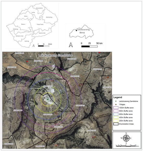
Figure 1.
Location of Lekokoaneng sandstone quarry with concentric buffer zones and surrounding villages.
In summary, out of all the households surveyed in the area, an estimated 47% to 59% reported that sandstone quarrying had a direct or indirect positive impact on their income, either through full-time employment at quarry sites or from operating small businesses nearby. These impacts were mostly found in the closest and middle buffer zones, where both legal and illegal quarry activities are found. In comparison, households in outer zones reported minimal to no income benefits from quarrying, relying instead on alternative livelihoods such as subsistence farming or informal trade. To quantify the household income impact in any buffer zone, a formula (Equation (2)) was generated to determine the gradient of economic impact as one moves away from the quarry site.
where Iq = Average income from quarrying per household;
Pe = Proportion of households employed in quarrying;
Ae = Average income from employment;
Pb = Proportion of households generating income through quarry-related businesses;
Ab = Average monthly income from businesses related to quarrying.
The positive impact range per buffer zone reported in the study reflects variations in survey responses across zones, informal vs. formal employment, temporal differences, and gender or age-based household roles.
This is expressed in Equation (3) as
where Pt = Percentage of households with positive income impact;
Hp = Number of households with a positive impact;
Ht = Total number of surveyed households.
3.2. Employment Opportunities
Employment opportunities created by quarrying were categorised into new employment, displaced employment, no opportunities, and mixed responses (Figure 2). The 0–200 m buffer zone recorded the highest employment impact at 47 percent, showing direct job creation. Middle buffer zones 401–600 m and 601–800 m recorded employment opportunities between 42.8 and 50 percent, demonstrating quarrying’s role in labour markets. However, 29.4 percent of respondents in the closest buffer zone noted displaced employment due to quarry expansion. The 201–400 m and 800–1000 m zones recorded the lowest employment impact, with 56 to 76.9 percent of respondents declaring no direct benefits from quarrying.
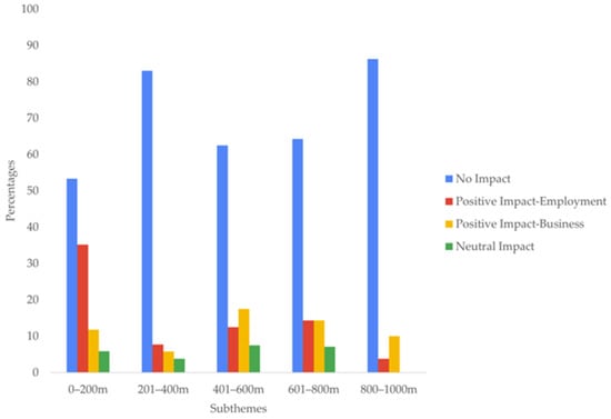
Figure 2.
Household income impact across buffer zones (N = 203 total; 0–200 m: N = 17, 201–400 m: N = 52, 401–600 m: N = 40, 601–800 m: N = 14, 801–1000 m: N = 80).
In summary, out of all households surveyed, approximately 47percent to 50 percent of households located within 0–600 m of the quarry reported new employment opportunities created by sandstone quarrying, particularly in zones closer to active extraction sites. However, these benefits were uneven, as up to 29.4 perecent of respondents in the same zones also reported that quarrying had displaced existing jobs or disrupted prior income-generating activities. Notably, zones further from the quarry (201–400 m and 800–1000 m) showed limited benefit, with over 56 percent to 76.9 percent of respondents indicating no significant employment impact. These findings suggest that proximity to the quarry strongly influences employment outcomes, creating opportunities for some, while displacing others or leaving many unaffected.
To quantitatively assess employment effects per zone, the Employment Opportunity Index (EOI), as proposed by [], was used. The Employment Opportunity Index (EOI) is a multidimensional measure of job market perceptions based on both positive (job creation) and negative (job displacement or exclusion). This theorem is expressed in the equation below (Equation (4)).
where Pn = Proportion of households or respondents reporting new employment opportunities due to quarrying.
Pd = Proportion of households or respondents reporting displacement from previous employment because of quarry operations.
A positive EOI value indicates that quarrying generates net employment gains, whereas a negative value reflects situations where job losses outweigh opportunities, highlighting displacement as the dominant outcome.
3.3. Livelihood Impact
The livelihood impact of quarrying was examined across four themes. These were easier livelihoods, harder livelihoods, no impact, and mixed responses (Figure 3). A total of 47 percent of respondents from the 0–200 m buffer zone reported easier livelihoods due to quarry-related income opportunities. Similarly, 50 percent of respondents in the 401–600 m zone reported livelihood improvements. However, 23.5 percent of respondents in the closest buffer zone noted that quarrying had made their livelihoods harder, primarily due to environmental degradation affecting agricultural productivity. 77.5 percent of respondents in the 801–1000 m buffer zone indicated no impact, demonstrating that socio-economic benefits diminish with distance.
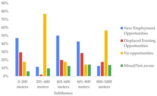
Figure 3.
Employment patterns across buffer zones (N = 203; buffer zone sample sizes as above).
In all surveyed households across different buffer zones, the closest buffer zone (0–200 m) reported the most significant improvement in livelihoods, with 47 percent of respondents indicating that sandstone quarrying had made life easier through increased income and related opportunities. Similarly, 50 percent of those in the 401–600 m zone also reported easier livelihoods. However, these improvements were not universal. In the 0–200 m zone, 23.5 percent of respondents noted that quarrying had made their livelihoods harder, largely due to environmental degradation and reduced agricultural productivity. The farthest zones (801–1000 m) showed minimal benefit, with 77.5% of respondents reporting no impact on their livelihoods. These findings suggest that the livelihood benefits of quarrying are spatially uneven, concentrated close to the quarry but diminishing with distance, and offset by emerging environmental and social challenges.
3.4. Access to Water, Food, and Other Resources
The study assessed the influence of quarrying on access to essential resources, categorising responses into negatively affected, no impact, and indifferent (Figure 4). The 0–200 m buffer zone recorded 47 percent of households experiencing negative impacts, including water contamination, dust pollution, and reduced soil fertility. In contrast, households in the 801–1000 m zone recorded 93.75 percent, indicating no impact, reinforcing the view that environmental risks are concentrated near the quarry.
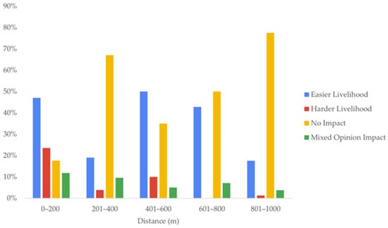
Figure 4.
Livelihood Impact across buffer zones (N = 203; buffer zone sample sizes as above).
The survey findings reveal that the impact of sandstone quarrying on access to water, food, and other essential resources is highly localised. In the closest buffer zone (0–200 m), 47 percent of respondents reported negative effects, primarily due to environmental degradation, including dust pollution, water contamination, and reduced land suitability for food production. Waste materials such as fragmented sandstone, fine particulate dust, and sediment runoffs are discarded near the quarry site without containment. These loose heaps contribute to dust dispersion during windy seasons and runoff-driven soil and water contamination during rainfall. No sediment traps, drainage systems, or waste recovery infrastructure were observed. These findings align with regional studies that highlight unmanaged quarry waste as a driver of environmental vulnerability [,,,]. In contrast, the farthest zone (801–1000 m) reported minimal disruption, with 93.75 percent of households indicating no impact on their access to resources. These results suggest that proximity to quarrying activities directly influences household-level vulnerability to resource access, highlighting the need for targeted environmental management and mitigation strategies in communities closest to extraction sites.
3.5. Health Impact and Medical Attention
Health effects were categorized into sought medical attention, no medical attention, and uncertain responses (Figure 5). 12.5 percent of respondents in the 401–600m buffer zone reported seeking medical attention for respiratory issues linked to dust exposure. Respondents in the 0–400 m zones reported uncertainty, suggesting underreporting or a lack of formal health assessments. The 601–800 m and 801–1000 m zones recorded 100 percent of respondents stating that no medical attention was sought, indicating lower perceived health risks in distant areas.
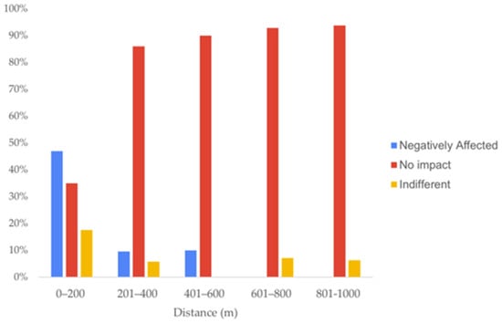
Figure 5.
Impact of quarrying on access to resources across buffer zones (N = 203; buffer zone sample sizes as above).
Perceptions of the impact that sandstone quarrying has on health appear to be limited and similar. Across all buffer zones, most respondents reported no need to seek medical attention, with respondents in the 601–800 m and 801–1000 m zones recording 100% under this theme. However, 12.5 percent of respondents in the 401–600 m zone reported having sought medical attention due to quarry-related conditions, while some households in the 0–400 m zones expressed uncertainty about the link between quarrying and their health status. These findings suggest that while quarrying-related health concerns are not widely reported, possible underreporting or lack of formal diagnosis may obscure the true extent of health impacts, particularly in closer zones. The data highlights the need for community health education and regular environmental health assessments in quarry areas to better understand and manage potential health risks.
3.6. Health and Safety Concerns
Community concerns about health and safety risks were categorized into concerns present, no concerns, and minor concerns (Figure 6). 64.7 percent of respondents in the 0–200 m buffer zone expressed serious concerns, particularly about dust-related illnesses and water contamination risks. Similarly, 64 percent of respondents in the 601–800 m buffer zone reported safety concerns. The 201–400 m and 801–1000 m zones recorded fewer concerns, with 69 percent and 75 percent of respondents stating no significant issues. Only 6.25 percent of respondents in the farthest zone reported minor concerns, primarily about speculative health risks.
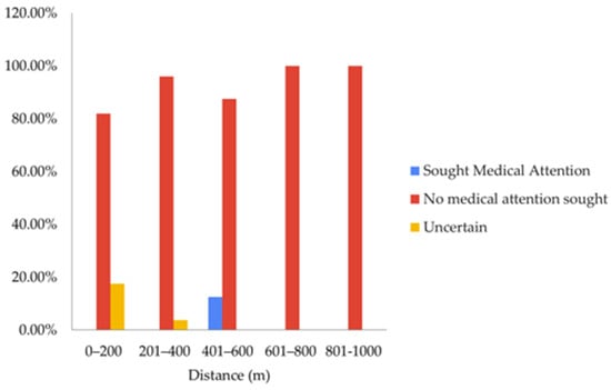
Figure 6.
Health impact across buffer zones (N = 203; buffer zone sample sizes as above).
In summary, out of the respondents surveyed, 64.7% in the 0–200 m buffer zone and 64% in the 601–800 m zone expressed clear health and safety concerns related to quarrying, such as dust-related illnesses like tuberculosis and potential waterborne diseases due to contamination. In contrast, “No Concerns” dominated the responses of the 201–400 m (69%) and 801–1000 m (75%) zones, suggesting that perceptions of risk decrease with distance from the quarry. Only 6.25% in the farthest zone (801–1000 m) expressed minor, speculative concerns. These findings reveal that proximity to quarrying activity strongly influences health and safety problems and perceptions of the prevalence of such problems, underlining the importance of targeted health interventions and risk communication strategies for communities closest to the quarry sites. In essence, although no mineralogical testing was conducted at the site, sandstone from the Clarens Formation is known to contain quartz, which can pose respiratory risks when released into the air as fine dust [,]. The absence of dust suppression systems and protective equipment increases potential exposure, particularly in households within the 0–600 m buffer zones. No formal health assessments or dust dispersion studies were available for Lekokoaneng, reflecting broader gaps in environmental monitoring.
3.7. Thematic Analysis
A qualitative approach was used in this study to gather information about participants’ understanding of the economic impact of sandstone quarrying in Lekokoaneng, Lesotho, and the meanings attached to their encounter with it were analysed through thematic analysis. [] formulated a six-phase guide, which is a very useful framework for conducting this kind of analysis. In this study, thematic analysis was used to analyse the interview responses from the perspectives of familiarisation, coding, generating categories, reviewing themes, defining and naming themes, to writing up the results. The results obtained contained the following four themes: Socio-Economic Empowerment, job creation and household income variety; Livelihood Vulnerability, reduced agricultural productivity and relocation because of quarrying; Health and Safety Risks, including respiratory illnesses, dust exposure, accident hazards; and Environmental Degradation and Control, covering soil erosion, vegetation loss, water contamination, and ineffective mitigation measures (Figure 7). The theme of environmental degradation and control captures community concerns about unmanaged waste, including dust exposure, sediment runoff, and the absence of formal recovery or mitigation systems. Moreover, field observations revealed no formal drainage infrastructure or sediment traps. This absence increases the risk of sediment-laden runoff entering nearby water sources, particularly during rainfall. Similar studies elsewhere in Southern Africa have linked quarrying to elevated turbidity, hydrocarbon contamination, and reduced water quality in adjacent communities. These risks are compounded by the lack of institutional monitoring or environmental safeguards.
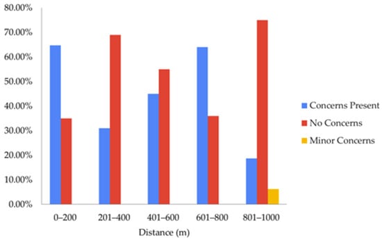
Figure 7.
Health and Safety concerns across buffer zones (N = 203; buffer zone sample sizes as above).
4. Discussion
Quarrying is widely recognised as a twofold activity, offering economic opportunities while simultaneously causing significant environmental and social challenges. In most developing countries, it serves as a critical source of employment, livelihood support, and local economic growth, yet these benefits often come with environmental degradation and health risks [,]. Thus, it is imperative to look at the importance of adopting a framework which will not only looks at the economic contributions but also the environmental costs and social well-being of people.
In this study, the use of the Sustainable Livelihood Framework (SLF) and Sustainable Development Theory (SDT) provided a holistic analysis of the environmental and socio-economic dynamics of sandstone quarrying in Lekokoaneng. The SLF highlights the role of human capital, social capital, natural capital, financial capital and physical capital in creating livelihood outcomes, while SDT offers a framework of understanding development processes in terms of social, environmental and economic aspects. By linking quarrying impacts to these frameworks, the thematic analysis was used to show the coordinated nature of economic empowerment, environmental degradation, livelihood vulnerability, and health and safety concerns.
The framework puts quarrying at the centre of a network of interrelated outcomes, showing how its benefits and challenges intersect across the dimensions of SLF and SDT (Figure 8).
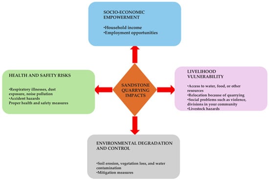
Figure 8.
A thematic framework analysis for sandstone quarrying impacts in Lekokoaneng, Lesotho.
The thematic framework developed in this study (Figure 8) positions quarrying at the centre of a network of interrelated outcomes, demonstrating how its benefits and challenges intersect across livelihood capitals and sustainability dimensions. For example, employment opportunities may temporarily empower households, but informal, seasonal work fails to generate lasting skills, leaving human capital fragile. Similarly, small business activities flourish around the quarry, but illegal operations and disputes in mid-range buffer zones weaken social cohesion, reflecting an erosion of social capital. Environmental degradation exacerbates these vulnerabilities, eroding natural capital through water scarcity, dust, and loss of soil fertility, which in turn reduces agricultural productivity and food security. Infrastructure deficits, such as poor access roads, further show how physical capital remains neglected despite the quarry’s economic contribution. These interconnections illustrate how empowerment and vulnerability are not isolated but occur simultaneously, reinforcing one another in ways that shape household resilience.
By integrating quantitative indicators such as the Income Gradient and Employment Opportunity Index with qualitative insights from thematic analysis, the study highlights how quarrying is more than an economic driver; it is a livelihood system marked by trade-offs. Financial gains are concentrated close to the quarry, but so are the steepest environmental costs. Households in outer buffer zones (801–1000 m) experience fewer risks but also miss out on economic opportunities, underscoring the spatial inequalities embedded in extractive economies []. These findings align with []’s critique of livelihood strategies as “sustainability trade-offs,” where immediate gains mask long-term vulnerabilities.
While this study employed a descriptive approach to communities’ lived experiences, future research could apply inferential techniques such as regression or multilevel modelling to explore causal relationships and spatial patterns more rigorously. This would be particularly valuable in assessing the statistical significance of livelihood outcomes across buffer zones and in linking environmental exposure to health risks.
In this sense, (Figure 9) is not merely schematic but a representation of how quarrying shapes livelihoods in Lekokoaneng: as a nexus of economic empowerment, vulnerability, degradation, and risk. It captures the dynamic interplay between SLF capitals and SDT principles, making visible the contradictions of quarry-led development. The challenge, therefore, is not simply whether quarrying brings benefits, but whether those benefits can be structured in ways that do not erode the ecological and social foundations of community resilience. In the absence of deliberate interventions such as environmental safeguards, institutional oversight, and reinvestment in infrastructure, quarrying risks entrenching cycles of fragility rather than fostering sustainable livelihoods.
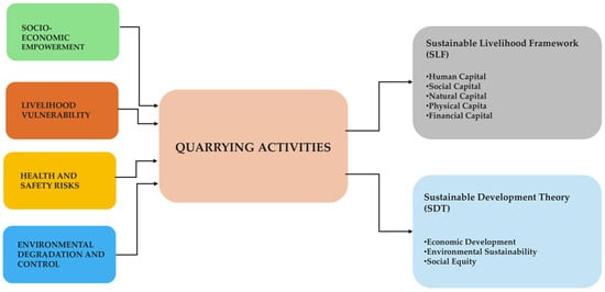
Figure 9.
Thematic framework linking the SLF and SDT in Lekokoaneng, Lesotho.
5. Conclusions
The socio-economic impacts of sandstone quarrying in Lekokoaneng reveal a complex interplay between livelihood opportunities and sustainability challenges. Quarrying generates direct income and employment, particularly within the 0–600 m buffer zones, while also stimulating small business activities that contribute to local economic empowerment. However, these benefits are unstable, largely informal, and concentrated in areas most exposed to severe environmental degradation, including dust pollution, water contamination, and soil fertility loss. By applying the Sustainable Livelihood Framework (SLF) and Sustainable Development Theory (SDT), the study demonstrates how quarrying simultaneously enhances financial capital and undermines natural, social, and human assets, thereby weakening long-term livelihood resilience. Thematic analysis was undertaken to explore this duality, with empowerment coexisting alongside vulnerability and environmental decline. Quarrying in Lekokoaneng thus reflects a “double-edged” development pathway, where short-term gains are offset by long-term risks to sustainability. To realign quarrying with sustainable development, stronger institutional oversight, community-inclusive governance, and corporate reinvestment in physical and social infrastructure are essential. Environmental safeguards must be prioritised to mitigate dust, water, and soil impacts, while formalising employment can strengthen financial and human capital. Without such measures, quarrying risks locking communities into fragile livelihoods that compromise intergenerational equity and broader progress towards the Sustainable Development Goals. Ultimately, the Lekokoaneng case illustrates the need for policies that balance extraction with stewardship, therefore transforming quarrying from a narrow economic driver into a platform for resilient and sustainable community development.
Author Contributions
Conceptualization, L.M. and N.M.; methodology, L.M. and N.M.; formal analysis, L.M.; investigation, L.M.; validation, L.M. and N.M.; resources, L.M. and N.M.; data curation, L.M.; software, L.M.; writing-original draft preparation, L.M.; writing—review and editing, L.M. and N.M.; visualisation, L.M.; supervision, N.M.; project administration, L.M. and N.M.; funding acquisition, L.M. All authors have read and agreed to the published version of the manuscript.
Funding
This research was funded by the Government of Lesotho through the National Manpower Development Secretariat (NMDS). Grant Number: 202321000128.
Institutional Review Board Statement
The study was reviewed and approved by the Ethics Committee of Cape Peninsula University of Technology under Reference No: 231091834/11/2023.
Data Availability Statement
The data presented in this study are available on request from the corresponding author due to ethical considerations.
Acknowledgments
All participants who generously shared their time and experiences for this research are fully acknowledged. Full responsibility for the final content and its scholarly contributions is taken. Gratitude is also extended to the Bureau of Statistics, Lesotho, for providing essential statistical data.
Conflicts of Interest
The authors declare no conflicts of interest.
Abbreviations
The following abbreviations are used in this manuscript:
| SLF | Sustainable Livelihood Framework |
| SDT | Sustainable Development Theory |
References
- Baffour, A. The Africa Factbook: Busting the Myths; African Union: Addis Ababa, Ethiopia, 2020; 1124p. [Google Scholar]
- Legwaila, I.A.; Lange, E.; Cripps, J. Quarry reclamation in england: A review of techniques. J. Am. Soc. Min. Reclam. 2015, 4, 55–79. [Google Scholar] [CrossRef]
- Nartey, V.K.; Nanor, J.N.; Klake, R.K. Effects of Quarry Activities on some Selected Communities in the Lower Manya Krobo District of the Eastern Region of Ghana. Atmos. Clim. Sci. 2012, 2, 362–372. [Google Scholar] [CrossRef]
- Umar, J.; Oriri, O. Environmental Effect of Quarry Site on the Adjoining Neighborhood in Oluyole Local Government, Oyo State, Nigeria. Ghana J. Geogr. 2023, 15, 223–257. [Google Scholar] [CrossRef]
- Akanwa, A.O.; Okeke, F.I.; Nnodu, V.C.; Iortyom, E.T. Quarrying and its effect on vegetation cover for a sustainable development using high-resolution satellite image and GIS. Environ. Earth Sci. 2017, 76, 505. [Google Scholar] [CrossRef]
- Kafu-Quvane, B.; Mlaba, S. Assessing the Impact of Quarrying as an Environmental Ethic Crisis: A Case Study of Limestone Mining in a Rural Community. Int. J. Env. Res. Public Health 2024, 21, 458. [Google Scholar] [CrossRef]
- Twerefou, K.D. Mineral Exploitation, Environmental Sustainability and Sustainable Development in EAC, SADC and ECOWAS; Economic Commission for Africa: Addis Ababa, Ethiopia, 2009. [Google Scholar]
- Hilson, G. Small-Scale Mining in Africa: Tackling Pressing Environmental Problems With Improved Strategy. J. Environ. Dev. 2002, 11, 149–172. [Google Scholar] [CrossRef]
- Afrobarometer. Basotho Want Environmental Protection but Prioritise Jobs; The Pan-African Research Network: Maseru, Lesotho, 2022. [Google Scholar]
- Government of Lesotho. National Strategic Development Plan II 2018/19–2022/23: In Pursuit of Economic and Institutional Transformation for Private Sector-Led Jobs and Inclusive Growth; NDSP: Maseru, Lesotho, 2018. [Google Scholar]
- 2022 Lesotho Diamond Industry Performance Report; Lesotho Chamber of Mines: Maseru, Lesotho, 2022.
- Sagoe, D.C.; Tsra, G. Uncontrolled Sand Mining and its SocioEnvironmental Implications on Rural Communities in Ghana: A Focus on Gomoa Mpota in the Central Region. Int. J. Res. Eng. IT Soc. Sci. 2016, 6, 31–37. [Google Scholar]
- Turyahabwe, R.; Asaba, J.; Mulabbi, A.; Osuna, C. Environmental and Socio-economic Impact Assessment of Stone Quarrying in Tororo District, Eastern Uganda. East Afr. J. Environ. Nat. Resour. 2021, 4, 2707–4242. [Google Scholar] [CrossRef]
- Singhal, A.; Goel, S. Impact of Sandstone Quarrying on the Health of Quarry Workers and Local Residents: A Case Study of Keru, Jodhpur, India. In Treatment and Disposal of Solid and Hazardous Wastes; Springer International Publishing: Cham, Switzerland, 2022; pp. 97–118. [Google Scholar]
- Oshim, F.; Chukwuemeka, E.; Amaefule, W.A.; Ayajuru, N.C.; Amaeful, E.O.; Anumaka, C.C. Socioeconomic and Environmental Impacts of Quarrying in Nigeria: A Comprehensive Review of Sustainable Quarrying Practices and Innovative Technologies. SSRN Electron. J. 2024, XI, 2321–2705. [Google Scholar]
- Mahapatra, T. Environmental, social and health impacts of stone quarrying in Mitrapur panchayat of Balasore district, Odisha. Int. J. Sci. Res. Arch. 2023, 8, 678–688. [Google Scholar] [CrossRef]
- Banchirigah, S.M. Challenges with eradicating illegal mining in Ghana: A perspective from the grassroots. Resour. Policy 2008, 33, 29–38. [Google Scholar] [CrossRef]
- Campbell, B.K. Regulating Mining in Africa: For Whose Benefit? Nordiska Afrikainstitutet: Uppsala, Sweden, 2004; 89p. [Google Scholar]
- Chuhan-Pole, P.; Dabalen, A.L.; Land, B.C. Mining in Africa: Are Local Communities Better off? The World Bank: Uppsala, Sweden, 2017. [Google Scholar]
- Government of Lesotho. Lesotho Mines and Minerals Act, 2005–Section 54; NDSP: Maseru, Lesotho, 2005. [Google Scholar]
- Ambastha, S.K.; Haritash, A.K. Emission of respirable dust from stone quarrying, potential health effects, and its management. Environ. Sci. Pollut. Res. 2022, 29, 6670–6677. [Google Scholar] [CrossRef] [PubMed]
- Sairanen, M.; Rinne, M. Dust emission from crushing of hard rock aggregates. Atmos. Pollut. Res. 2019, 10, 656–664. [Google Scholar] [CrossRef]
- Sairanen, M.; Rinne, M.; Selonen, O. A review of dust emission dispersions in rock aggregate and natural stone quarries. Int. J. Min. Reclam. Environ. 2018, 32, 196–220. [Google Scholar] [CrossRef]
- Bluvshtein, N.; Mahrer, Y.; Sandler, A.; Rytwo, G. Evaluating the impact of a limestone quarry on suspended and accumulated dust. Atmos. Environ. 2011, 45, 1732–1739. [Google Scholar] [CrossRef]
- DFID (The Department for International Development). Sustainable Livelihoods Guidance Sheets; Department for International Development: London, UK, 1999. [Google Scholar]
- Scoones, I. Livelihoods perspectives and rural development. J. Peasant. Stud. 2009, 36, 171–196. [Google Scholar] [CrossRef]
- Natarajan, N.; Newsham, A.; Rigg, J.; Suhardiman, D. A sustainable livelihoods framework for the 21st century. World Dev. 2022, 155, 105898. [Google Scholar] [CrossRef]
- Schmitz, G.; Rooyani, F. Lesotho Geology, Geomorphology, Soils; Morija Printing Works: Maseru, Lesotho, 1987. [Google Scholar]
- Bordy, E.M.; Smith, R.M.H.; Choiniere, J.N.; Rubidge, B.S. Selected Karoo geoheritage sites of palaeontological significance in South Africa and Lesotho. Geol. Soc. Lond. Spec. Publ. 2024, 543, 431–446. [Google Scholar] [CrossRef]
- Catuneanu, O.; Wopfner, H.; Eriksson, P.G.; Cairncross, B.; Rubidge, B.S.; Smith, R.M.H.; Hancox, P.T. The Karoo basins of south-central Africa. J. Afr. Earth Sci. 2005, 43, 211–253. [Google Scholar] [CrossRef]
- Rubidge, B.; John, H.; Richard, M. Waterford Formation in the south-eastern Karoo: Implications for basin development. S. Afr. J. Sci. 2012, 108, 3. [Google Scholar] [CrossRef]
- Baiyegunhi, C.; Liu, K. Sedimentary facies, stratigraphy, and depositional environments of the Ecca Group, Karoo Supergroup in the Eastern Cape Province of South Africa. Open Geosci. 2021, 13, 748–781. [Google Scholar] [CrossRef]
- The World Bank Group. Climate Risk Profile: Lesotho. 2021. Available online: https://climateknowledgeportal.worldbank.org/sites/default/files/country-profiles/15930-WB_Lesotho%20Country%20Profile-WEB.pdf (accessed on 13 October 2025).
- Government of Lesotho–Bureau of Statistics. 2023 Environment Report: Statistical Report No. 11. Maseru. 2025. Available online: http://www.bos.gov.ls/Publications.htm (accessed on 13 October 2025).
- Ministry of Health [Lesotho] and ICF. Lesotho Demographic and Health Survey 2023–2024: Key Indicators Report; Ministry of Health: Maseru, Lesotho; ICF: Rockville, MD, USA, 2024. [Google Scholar]
- The World Bank. Lesotho Poverty Assessment: Progress and Challenges in Reducing Poverty; World Bank Group: Washington, DC, USA, 2019. [Google Scholar]
- Government of Lesotho. 2024 Labour Force Survey (LFS) Report: Statistical Report No. 20 of 2025; NDSP: Maseru, Lesotho, 2025. [Google Scholar]
- Bureau of Statistics; UNFPA: Maseru, Lesotho, 2019.
- Braun, V.; Clarke, V. Using thematic analysis in psychology. Qual. Res. Psychol. 2006, 3, 77–101. [Google Scholar] [CrossRef]
- Yamane, T. Statistics: An Introductory Analysis, 2nd ed.; Harper and Row: New York, NY, USA, 1967. [Google Scholar]
- Griffeth, R.W.; Steel, R.P.; Allen, D.G.; Bryan, N. Employment Opportunity Index. In PsycTESTS Dataset; APA PsycNect: Washington, DC, USA, 2011. [Google Scholar]
- Damte, B.; Semayat, O. Assessing the Impact of Stone Quarrying on the Landscape, Crop and Grazing Land Degradation in Loma Bosa District, Dawuro Zone, Southern Ethiopia. Int. J. Sci. Res. Civ. Eng. 2021, 5, 79–91. [Google Scholar]
- Eskanlou, A.; Arnold, B.J. An evaluation of quartz as a component of respirable coal dust. J. Hazard. Mater. 2025, 490, 137873. [Google Scholar] [CrossRef] [PubMed]
Disclaimer/Publisher’s Note: The statements, opinions and data contained in all publications are solely those of the individual author(s) and contributor(s) and not of MDPI and/or the editor(s). MDPI and/or the editor(s) disclaim responsibility for any injury to people or property resulting from any ideas, methods, instructions or products referred to in the content. |
© 2025 by the authors. Licensee MDPI, Basel, Switzerland. This article is an open access article distributed under the terms and conditions of the Creative Commons Attribution (CC BY) license (https://creativecommons.org/licenses/by/4.0/).