Abstract
Since 1980, a land use type known as parcelas de agrado has developed in Chile, generating a series of social, economic, and environmental impacts. In recent years, its use has increased further and has become a subject of public debate. To address this, it is necessary to have evidence that documents its evolution. Within this context, the aim of the article is to analyze the state of the literature on parcelas de agrado in Chile. The method is based on three stages: the application of the PRISMA model for the identification and selection of documents, the establishment of areas and categories for quantitative analysis, and content analysis based on five dimensions. The results show a diversity of types of studies conducted in different years, territories, and scales in Chile, with a greater concentration of scientific articles and studies in areas of the central macrozone of Chile. The discussion highlights the diversity and proliferation of studies, facilitating elements and the spread of parcelas de agrado, the consequences on the territory, as well as the contribution of spatial planning. It is concluded that parcelas de agrado in Chile require greater attention from the State in relation to the territorial planning of rural, peri-urban, and suburban areas.
1. Introduction
1.1. Historical Context and Initial Definitions
Since the late 1970s, urban expansion and growth in Chile have developed within a political-economic framework oriented toward liberalization and private sector decision-making, governed by the logic of the land market rather than State planning and intervention [1]. A geospatial expression of this corresponds to the origin of parcelas de agrado, which emerged as a result of two regulations stemming from the agrarian counter-reform that had a significant impact on rural areas [2]. The first is the National Urban Development Policy [3], which liberalized the land market by defining land as a non-scarce resource and allowed the private sector to set the guidelines for urban growth through the land market. The second, and a consequence of the first, is Decree Law (DL) 3.516 [4], which allowed for the subdivision of rural properties into plots no smaller than 0.5 hectares, leading to the creation of parcelas de agrado [2,5].
Parcelas de agrado are a type of human settlement consisting of subdivisions no smaller than 0.5 hectares, featuring high-quality housing materials, and inhabited primarily by people from middle and upper socioeconomic strata [6,7]. These parcelas de agrado have produced changes in the traditional characteristics of rural areas and nearby urban zones, where in some regions they have become significant growth poles [6,8].
The expansion of parcelas de agrado has generated geospatial transformations that may be considered both negative and positive. Among the negative effects are impacts on property regulation, land resource availability, threats to water security, and the reproduction of socio-spatial segregation. On the positive side, they have the potential to strengthen tourism, boost trade, and improve municipal economies [6,7,8]. Moreover, this type of human settlement tends to be located near urban areas and brings about changes in land use, primarily shifting from agricultural to residential use [9,10]. In this way, it influences the development of a mixture of land uses in periurban areas [11], thereby generating the need to redefine the concepts of urban and rural, and giving rise to new categories such as suburban areas [2].
1.2. Suburban Areas: Definition and Characteristics
Suburbanization is a complex phenomenon [12], which although it has a global scope, its study has focused mainly on North America, Western Europe and Australia [13]. Initially, it was the railroad that drove the development of suburbanization in the United States [14], and then began to develop from the 1940s in the United States and the 1960s in Western Europe [15], after the Second World War [16]. Ekers, Hamel & Keil [17] indicate that suburbanization is a new form of urban expansion over rural areas resulting from the combination of urban population movement and surplus economic growth. In this same sense, Logan [18] points out that it is one of the types of urban expansion, territorial reconfiguration and decentralization of the population. This implies an exodus from large cities to their surroundings [16], giving rise to local urban decentralization [19]. Pieretti [20] defines it as the growth and spatial reorganization of the contemporary city. It is the result of population movements and the relocation of urban activities to lower-density settlements. Boiteux-Orain & Huriot [12] claim that suburbanization decentralizes activities, reorganizes space into new concentrations and recomposes the space of differentiation. As a condition, it can be noted that this process emerges within metropolitan spaces [21].
From a broader perspective, Champion [16] suggests that this phenomenon is a stage within the territorial development model. These stages are: (i) urbanization, (ii) suburbanization, (iii) deurbanization, and (iv) reurbanization. Therefore, suburbanization is considered a second-generation process for the most industrialized countries; however, for this study, suburbanization is a territorial dynamic currently in force in Chile. Among the causes of suburbanization, Logan & Molotch [22] complement by indicating that the current driving forces of suburbanization are the land market and the free choice of the consumer. Within the suburbanization process, there are also stages. Hirt [23] proposes only two stages based on the current dynamics of suburbanization: (i) the State is in a process of capitalist development with a rather passive role due to a lack of resources, so private entities build suburban areas; and (ii) the State becomes capitalist and promotes suburbanization (or population deconcentration) with planning instruments and infrastructure.
Another point to address regarding suburbanization is the geospatial effects it entails. Thus, the suburban area is the product of suburbanization, which corresponds to a settlement outside the traditional central city [20]. The suburban area is a low-density settlement outside the urban fringe [13], a product of the depopulation of central areas [19]. In conclusion, it is a new way of inhabiting the territory, in a space distinct from traditional cities [24].
1.3. Research Problem, Objective, and Reading Plan
In recent years, parcelas de agrado have increased both in number and in total area throughout Chile, generating a series of social, economic, and environmental impacts. This rapid proliferation of parcelas de agrado has become the subject of public, technical, and political debate [25], for which it is necessary to have evidence documenting their evolution over the past four decades. Although some recent studies on parcelas de agrado already exist, there has not been a study that systematizes this body of work to provide a general overview that is also useful for regional and territorial planning. Consequently, the general objective of this study is to analyze the state of the literature on parcelas de agrado in Chile, based on scientific and technical documents. In addition to the background presented in this introduction, the article includes a methods section describing the stages carried out, followed by the presentation of results, discussion, and conclusion.
2. Materials and Methods of Research
The method is based on a mixed approach (quantitative and qualitative) carried out in stages. The first stage corresponds to the identification, selection, and inventory of academic literature and grey literature on parcelas de agrado in Chile, based on the PRISMA model. The second stage involves the establishment of areas and categories for descriptive quantitative bibliometric analysis. Finally, in the third stage, a qualitative content analysis of the literature is conducted through five dimensions.
2.1. Stage 1: Data Collection and Selection Using the PRISMA Model
The inventory of academic and grey literature is the first step of the research. This was developed based on bibliographic sources related to parcelas de agrado in Chile. Literature review is a methodological process that involves searching, identifying, reading, summarizing, compiling, and analyzing [26]. In this study, a systematic literature review was conducted using the PRISMA method (Preferred Reporting Items for Systematic Reviews and Meta-Analyses) [27,28], which facilitated an effective search and selection of bibliographic sources associated with the topic of parcelas de agrado in Chile (see Figure 1). The database search began on 25 March 2025 and concluded on 20 April 2025.
The search strategy was carried out by combining the terms “parcela de agrado” OR “parcelas de agrado,” applied to the entire content of the document. This combination was used for the languages Spanish, English, and Portuguese. For French, the concept or descriptor “parcelle d’agrément” was used. The bibliographic search was conducted through the following databases: Google (12 institutional documents), Google Scholar (146 academic documents) [29], Scopus (3 documents), Web of Science (2), and Scielo (1). The inclusion criteria were as follows:
- That the document contains at least one mention of the concept “parcela de agrado”;
- That the type of document be: public institution reports (grey literature [30]), undergraduate dissertations, postgraduate theses (master’s and doctoral dissertations), conference papers, and scientific articles;
- That the language be Spanish, English, French, or Portuguese;
- That the study be applied to an area within Chile.
After the identification stage, six duplicate documents were excluded. Subsequently, during screening, titles and abstracts of all documents were reviewed, during which three documents were excluded for being duplicates in another language, and thirteen records were excluded due to lack of access to the full document. Regarding documents with full access, the following were excluded: six documents that did not meet the “type of document” (Other types of documents not included in this systematic review are: presentations, opinion columns, editorials, preprints.) criterion and twelve documents whose study area was outside Chile. The exclusion criteria were as follows:
- That the document is of a different type than those indicated in the inclusion criteria;
- That the language is different from the four specified in the inclusion criteria;
- That it does not contain mentions of the concept parcela de agrado;
- That full access to its content is not possible;
- That the study was not applied to an area within Chile.
By applying all these criteria, the number of documents was reduced from an initial 164 to a final 124 (see Figure 1).

Figure 1.
PRISMA Methodology Flow Diagram. Source: authors’ own elaboration based on [27,28].
2.2. Stage 2: Definition of Categories and Descriptive Quantitative Bibliometric Analysis
Once the 124 documents were selected, they were reviewed considering the establishment of analytical domains with their respective categories (see Table 1). These domains and categories enable a better understanding of this phenomenon in Chile by providing a synthesis of the information studied and gathered on this subject. Two of the three domains are straightforward (publication type and geographic scale). However, the domain “degree of relevance” is more complex, and therefore a more detailed explanation is provided here:

Table 1.
Details of the Domains and Categories for Descriptive Quantitative Analysis.
- the “primary” degree addresses parcelas de agrado in depth by characterizing their main features and territorial aspects;
- the “secondary” degree addresses the topic with less attention, within broader themes that focus on rural areas;
- the “mere mention” category means that the concept of parcela de agrado appears in the document but is not further explored, as the focus is mainly on other topics.
The general overview of academic and institutional literature was conducted through bibliometric analysis with descriptive statistics, based on the domains and categories established in Table 1.
Another way to analyze and represent the data is based on the use of the open-source software VOSviewer (version 1.6.20) [31,32,33]. This software allows the visualization of bibliometric data regarding authors, collaborations, citations, and concepts, and it is easy and simple to use [34]. For the present literature review, the units of analysis are titles and keywords. Both are represented as nodes and links. In the first case, occurrence data (occ) is obtained, referring to the number of mentions across different documents. In the second case, link strength (LS) concerns co-occurrence, highlighting how often two words are mentioned together in more than one document [35]. Finally, a scientific mapping is produced with nodes, links, and clusters based on the degree of association among titles and keywords [36].
2.3. Stage 3: Qualitative Content Analysis
The second part of the research is addressed through a qualitative approach. For the development of content analysis, two criteria were defined. The first concerns the documents to which this analysis is applied. In this regard, the records with a “degree of relevance” of primary and secondary were analyzed, totaling 85 publications (see Table S1 in Supplementary Materials). The second criterion relates to five domains defined a priori, which provide structure to the data. The domains are: environmental, economic, social, political, and geospatial. The first three domains emerge directly from the framework of sustainable development, which values the social, economic, and environmental perspectives. The discourse emphasizes economic growth, social equity, and environmental sustainability. This convergence of the three dimensions is presented by Peter Nijkamp and his team [37] at the Annual World Bank Conference on Development Economics, where Sustainable Development is symbolized as a reconciliation zone between these three objectives, using a figure now known as the Nijkamp triangle. The graphic representation was later published [38]. To this, the political and geospatial dimensions are added due to the nature of the impact of the issue of parcelas de agrado in Chile. Based on each domain, the final step is the identification of key ideas that emerge from the literature review, which will help provide a global view of the complexity of this issue.
3. Results: Systematic Literature Review on Parcelas de Agrado
3.1. Bibliometric Analysis
3.1.1. Degree of Relevance and Year of Publication
The domain “degree of relevance” is the first to be described in the results. Of the 124 documents, 21.0% and 47.6% corresponded to the “primary” and “secondary” categories, respectively, and 31.5% of the documents were associated with the “mere mention” category (see Figure 2a). Two-thirds of the documents present a more in-depth analysis of the subject.
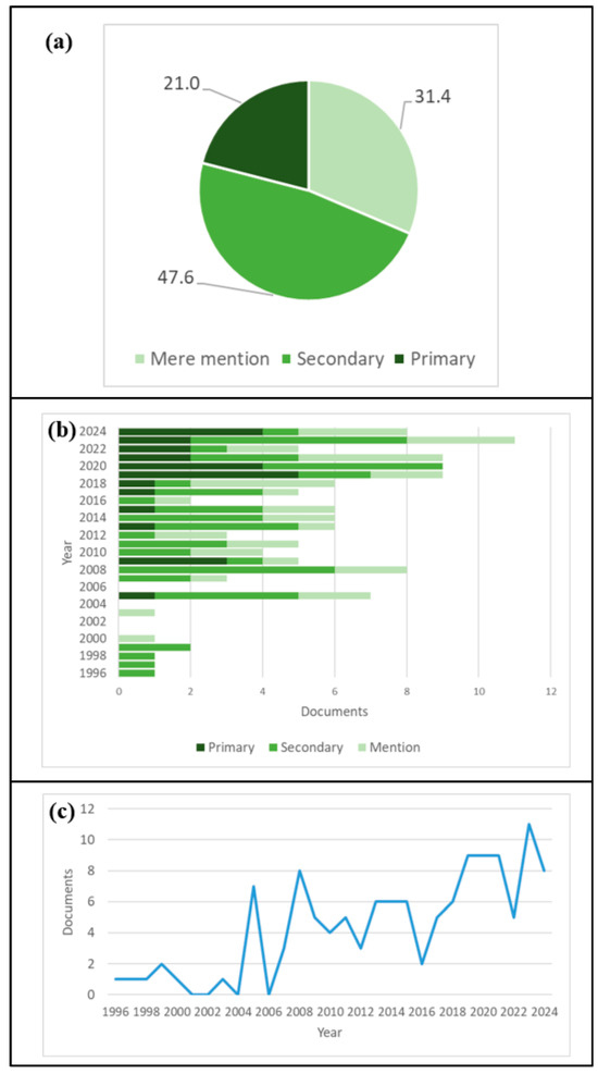
Figure 2.
(a) Distribution of documents on the degree of relevance associated with parcelas de agrado. (b) Frequency of documents associated with degree of relevance and (c) year of publication. Source: authors’ own elaboration.
Figure 2b shows the number of documents published from 1996 to 2024 for each category associated with the degree of relevance, in which a low number of documents can be seen between 1996 and 2004. From the latter year onward, a pattern of increasing publications is observed across the three categories. Focusing only on the “primary” and “secondary” categories, it can be seen that the second maintains a more consistent pattern over time, with a maximum of six documents in the years 2008 and 2023, in contrast to the “primary” category, which presents an irregular pattern from 1996 to 2016, with certain periods during which no associated documents were published, such as the periods 1996–2004 and 2010–2012. However, in contrast to its previous behavior, from 2016 to 2024 a steady pattern of publications can be observed each year, with a maximum of five in the year 2019.
In general terms, when observing the full-time range of the analysis and considering the three categories, there is a greater number of publications in the 2019–2024 period. Furthermore, during the 1996–2004 period, a low number of publications per year is noted, including some gaps in the years 2001, 2002, 2004, and 2006 (see Figure 2c). Finally, the most consistent category over time in terms of the number of publications per year corresponds to the “secondary” category.
3.1.2. Type of Document
Regarding the type of publication, a differentiated analysis is conducted, first examining the case for the “primary” and “secondary” categories and then analyzing the “mere mention” category separately.
In the case of the “primary” and “secondary” categories, there is a predominance of scientific articles, which represent 43.5% of the publications, followed by master’s theses and institutional documents with 15.3% and 12.9%, respectively (see Figure 3a). The remaining categories range between 9.4% (undergraduate dissertations) and 3.5% (doctoral dissertations).
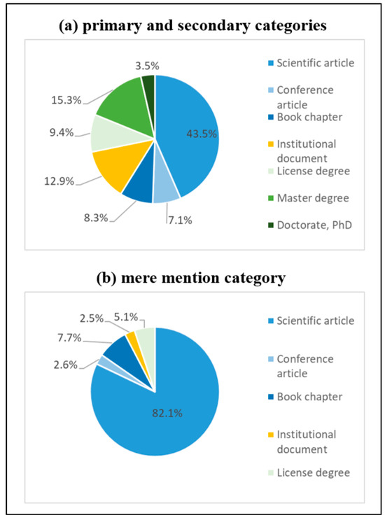
Figure 3.
Distribution by type of document for (a) the primary and secondary categories, and (b) the mere mention category. Source: authors’ own elaboration.
In the case of the “mere mention” category, there is a significant predominance of scientific articles (82.1%) over other types of documents, followed at a wide margin by book chapters and undergraduate dissertations with 7.7% and 5.1%, respectively. For this category, there are no documents corresponding to master’s theses, doctoral dissertations, or institutional documents (see Figure 3b).
3.1.3. Geographic Scale
As in the previous case, a differentiated analysis is conducted for the domain of geographic scale. In the grouping of “primary” and “secondary,” there is a predominance of documents associated with the communal scale (34.1%), followed by the inter-communal/metropolitan and regional scales (both with 20%) (see Figure 4a). The combined category of communal and local scale has the lowest representation, with 1.2% of the documents.

Figure 4.
Distribution of documents by geographic scale for (a) the primary and secondary categories, and (b) the mere mention category. Source: authors’ own elaboration.
In the “mere mention” category (see Figure 4b), there is a predominance of documents associated with the local and inter-communal/metropolitan scales, each with 23.1%, followed by the national scale with 20.5% of the documents. The combined category of communal and local scale again has the lowest representation, with 2.6%.
For the bibliometric analysis of document frequency associated with geographic scale, the information is presented separately by scale levels: regional, inter-communal/metropolitan, communal, and local. Likewise, the use of maps and tables is prioritized here.
Figure 5 shows the number of documents associated with the regional scale, with a predominance of documents in the central zone, specifically in the Metropolitan Region of Santiago (12 documents), followed by the Valparaíso Region (5). Next are the O’Higgins Region (2) and the Biobío and Los Ríos Regions (1 each). In the central zone regions, where the greatest number of documents are concentrated, topics are associated with the facilitating factors for the development of parcelas de agrado, with an emphasis on the impacts that parcelas have generated in rural areas, such as the loss of agricultural land and socio-spatial segregation. This takes on greater relevance given that the Metropolitan Region of Santiago has the largest surface area of high-quality agricultural soils [7]. In this region, parcelas de agrado represent an important factor of transformation in periurban spaces [11], with facilitating elements such as the Santiago Metropolitan Regulatory Plan, a strong influence of the real estate sector, and a high concentration of services and employment [9,39].
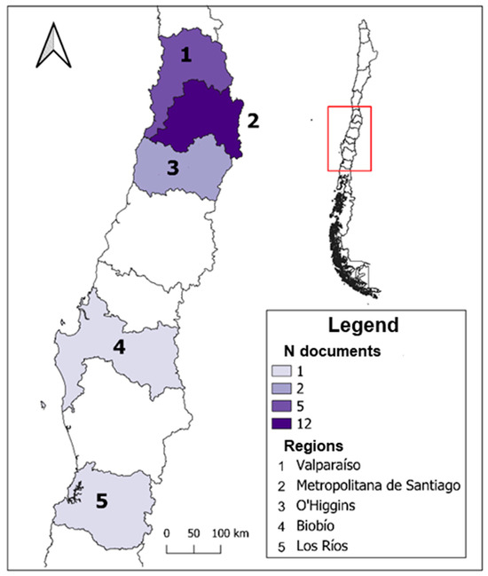
Figure 5.
Number of studies by territory according to regional geographic scale. Source: authors’ own elaboration.
With respect to the inter-communal/metropolitan scale (Figure 6), the territories are associated exclusively with the Metropolitan Region of Santiago and the Valparaíso Region. A large number of documents are associated with the Santiago Metropolitan Area (11 documents) and 4 documents with the Province of Chacabuco. Following these, the territory associated with the Valparaíso Metropolitan Area includes 3 associated documents (see Table 2) within the Valparaíso Region. At this scale, the documents mainly address topics of urban development in terms of the expansion of large cities such as Santiago de Chile and Viña del Mar—Valparaíso toward the peripheries [8]. Emphasis is placed here on socio-demographic transformation, highlighting the passive and facilitating role of the State and the strong influence of the real estate sector and economic-productive forces over land use control, where parcelas de agrado play an important role in the structural change in spatial organization in periurban areas [40].
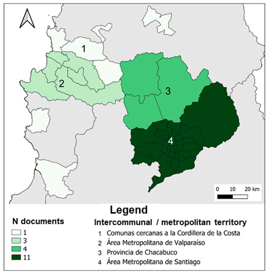
Figure 6.
Number of studies by territory according to inter-communal/metropolitan geographic scale. Source: authors’ own elaboration.
Table 2.
Number of studies by territory according to inter-communal/metropolitan geographic scale (ordered by number of documents).
For the communal geographic scale associated with the central zone, the pattern of document concentration remains, with a high number in the Metropolitan Region of Santiago (see Figure 7). In this region, documents are primarily associated with the commune of Melipilla (8 documents), followed by Talagante (7) and Buin (6) (see Table 3). The remaining communes shown in Figure 7 range from 3 to 1 associated documents, distributed across the three present regions (Metropolitan Region of Santiago, Valparaíso, and O’Higgins). In the specific case of the communes within the Metropolitan Region of Santiago, various dimensions associated with parcelas de agrado are characterized, such as the high proportion of land use for this purpose (in the commune of Talagante, it reaches nearly 50% of the communal surface area) and its impact in terms of socio-spatial segregation, loss of agricultural land, and communal management related to the high demand for basic services [10,41,42].
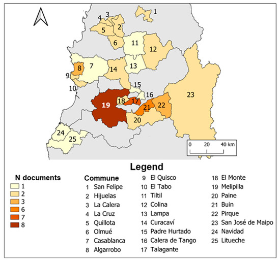
Figure 7.
Number of studies by territory according to communal geographic scale associated with the central zone. Source: authors’ own elaboration.
Table 3.
Number of studies by territory according to communal geographic scale associated with the central zone (ordered by number of documents).
In other zones of Chile—namely the Norte Chico, south-central, and southern zones—there is a significant difference in the concentration of documents compared to the central zone, as in the northern zone only the commune of La Serena is associated with a single document (see Figure 8). The south-central zone presents a rather homogeneous distribution in document frequency, with a maximum of 2 documents in the communes of San Fernando, Curicó, Constitución, and San Carlos. In the southern zone, there is a clear predominance of documents associated with the commune of Puerto Varas (6 documents), where topics are addressed concerning the increase in parcelas de agrado in recent decades due to the high concentration of natural and tourist attractions, which facilitate greater development of this type of settlement [43,44]. As for the other communes, there is a low frequency of documents (1 document) (see Table 4), as the development of parcelas de agrado remains more incipient. It is worth noting that from 2017 to 2024, there has been an expansion of these parcelas in the central and southern zones (this will be further explored later in the qualitative analysis) [7].

Figure 8.
Number of studies by territory according to communal geographic scale associated with the Norte Chico, south-central, and southern zones. Source: authors’ own elaboration.
Table 4.
Number of studies by territory according to communal geographic scale associated with the Norte Chico, south-central, and southern zones (ordered by number of documents).
With regard to the local geographic scale, which is below the communal level (see representation with dots in Figure 9 and its details in Table 5), the documents cover territories in both the central and southern zones of the country in a homogeneous manner (1 document for each locality). In the case of territories associated with the Valparaíso Region, the documents mainly address the impact of parcelas de agrado on protected wilderness areas, which manifests as pressure through land consumption and landscape-level effects [45]. In the territories associated with the Metropolitan Region of Santiago, the cases of the cities of Colina and Chicureo stand out, where significant geospatial, sociodemographic, and socioeconomic transformations have occurred due to intensive real estate development, in which parcelas de agrado have a major influence on the shift in land use from agricultural to residential [46]. In the southern zone, the predominant theme corresponds to amenity-driven migration associated with natural and scenic factors, which facilitate urban development and the growth of tourist zones. Here, as in the central zone, the lack of legal frameworks regulating occupation in rural spaces and the absence of territorial public policy instruments remains a relevant issue in the development of parcelas de agrado [47].
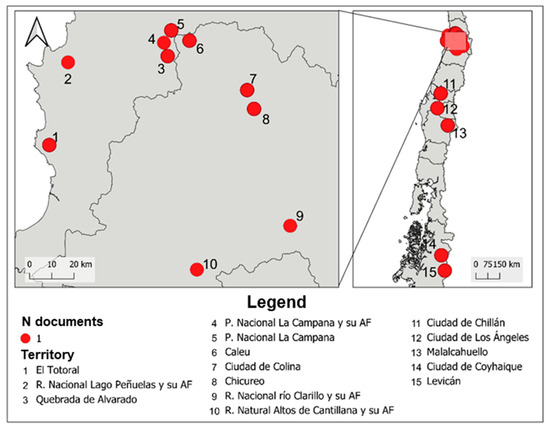
Figure 9.
Number of studies by territory according to local geographic scale. Source: authors’ own elaboration.
Table 5.
Number of studies by territory according to local geographic scale.
3.2. Analysis of Nodes and Conceptual Clusters in Titles and Keywords on Parcelas de Agrado
From the 85 documents whose “degree of relevance” was “primary” and “secondary,” bibliometric data were also obtained regarding nodes, links, and conceptual clusters, which are presented in Figure 10 using the VOSviewer software (version 1.6.20)as indicated in the methods section [31,32,33]. The upper part shows the words associated with the title of each record (see Figure 10a), and the lower part corresponds to the declared keywords (see Figure 10b).
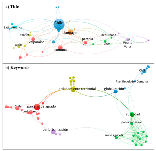
Figure 10.
Map of nodes, links, and conceptual clusters from the 85 documents with “primary” and “secondary” degree of relevance in the analysis of parcelas de agrado in Chile, by original language: (a) titles and (b) keywords. Source: authors’ own elaboration.
In the case of titles, 35 concepts are observed, grouped into seven clusters (represented by different colors), and the concepts appear dispersed and well distributed, with the concept “Chile” predominating with 27 occurrences (occ) in the documents analyzed. Other frequently mentioned concepts include: “Santiago” (11 occ), “Valparaíso” (6 occ), and “Puerto Varas” (5 occ), all of which are cities corresponding to study areas in the research. Also standing out are: “comuna” (8 occ) and “parcela” (6 occ), which are associated with notions of geospatial units. It is noteworthy that the full concept “parcela de agrado” does not appear explicitly, but instead the isolated concept “parcela” emerges (see Figure 10a).
In the keyword map, 41 concepts are observed, grouped into five clusters (represented by different colors), which appear clustered and tightly concentrated, in contrast to the previous case. Each cluster has a predominant concept (five in total), among which the following stand out: “parcelas de agrado” (8 occ), “ordenamiento territorial” and “periurbanización” (both with 6 occ), “ruralidad” and “Chili” (both with 5 occ) (see Figure 10b). Table 6 and Table 7 contain the detailed list of others concepts identified in the titles (Table 6) and in the keywords (Table 7) of the 85 records analyzed.
Table 6.
Details of the concepts that make up the clusters in the titles, by original language (Spanish and English).
Table 7.
Details of the concepts that make up the clusters in the keywords, by original language (Spanish and French).
3.3. Qualitative Content Analysis of Studies on Parcelas de Agrado
From the five domains defined in the methods section, a total of 31 key ideas emerged, which are presented under their respective domain: environmental (four key ideas) (Table 8), economic (six key ideas) (Table 9), social (five key ideas) (Table 10), political (five key ideas) (Table 11), and geospatial (eleven key ideas) (Table 12). Each of these includes a description of the content associated with its corresponding source.
Table 8.
Content supporting the key ideas within the environmental domain.
Table 9.
Content supporting the key ideas within the economic domain.
Table 10.
Content supporting the key ideas within the social domain.
Table 11.
Content supporting the key ideas within the political domain.
Table 12.
Contents Supporting the Key Ideas in the Geospatial Domain.
4. Discussion and Conclusions
The discussion aims to provide a synthesis and interpretation of the reviewed literature according to the following themes:
- Diversity and proliferation of studies;
- Facilitating elements and the proliferation of parcelas de agrado in Chile;
- Consequences associated with parcelas de agrado in Chile;
- Territorial planning as a response for the balanced development of land uses;
- Methodological approach and the use of VOSviewer;
- Conclusions and future studies.
4.1. Diversity and Proliferation of Studies
In the introduction to this article, the need for a study that synthesizes the different publications on this subject was mentioned. Thus, the objective was proposed to analyze the state of the literature on parcelas de agrado in Chile, based on scientific and technical documents. This objective was fulfilled in the present study using the PRISMA model as the methodological basis. A total of 124 documents were analyzed through bibliometric analysis using a quantitative approach; meanwhile, 85 documents were examined for the cluster and conceptual node analysis, and the identification of 31 key ideas within five domains of analysis: environmental, economic, social, political, and geospatial.
One notable aspect of the results is the diversity and proliferation of studies on parcelas de agrado. Studies were identified in which this topic was the primary or secondary focus, while in others it was only mentioned. Likewise, there is a significant diversity in the type of documents reviewed, which included: scientific articles, conference papers, master’s theses, doctoral dissertations (PhD), undergraduate dissertations, book chapters, and institutional technical documents (grey literature). Additionally, it was found that the studies cover several geographic scales: local, communal, inter-communal/metropolitan, regional, and national. A final relevant aspect is the publication period, which ranges from 1996 to the present. This corresponds to nearly 30 years of history, with the past six years showing the highest frequency of studies.
4.2. Facilitating Elements and the Proliferation of Parcelas de Agrado in Chile
Another aspect discussed relates to converging themes within the reviewed publications. Among these themes, the elements that facilitated the proliferation of parcelas de agrado stand out. A common point of convergence is the regulation that allowed their development, namely Decree Law 3.516 [4], as well as the National Urban Development Policy [3], which promoted land market liberalization by defining land as a non-scarce resource. To this must be added the absence of public policy instruments with greater autonomy at the regional level to plan and regulate rural spaces, which facilitated the predominance of the private sector in determining land uses in these areas through the land market [72]. This has led to a situation in which the communal level has few tools to respond to local demands, contributing to an unplanned urbanization process [8].
When examining public policy instruments that influence rural spaces, it becomes clear that there are indeed strategic and planning tools at both regional and communal levels, such as the Regional Territorial Plan and the Communal Development Plan. However, these instruments often come into conflict with urban regulatory instruments (Metropolitan/Inter-communal and Communal Regulatory Plans), which have greater influence over land use regulation. For example, the Santiago Metropolitan Regulatory Plan [68] acknowledged the pre-existence of parcelas de agrado through the designation of “Mixed Silvoagricultural Interest Areas”, which were mainly intended to allocate land for urban expansion rather than for integrated territorial planning [39].
These facilitating elements contribute to the development and proliferation of parcelas de agrado, raising the question: why has this proliferation occurred in Chile? Before providing a specific answer for Chile, there are two studies that offer useful insights. For instance, Rigolon et al. [77] conducted a study based on publications addressing access to green spaces in cities of the Global South. This study highlights that green spaces generate and promote leisure and physical and mental well-being. Similarly, Xu et al. [78] carried out a systematic literature review examining the relationship between green spaces and mental health. This work strongly aligns with the previous one, indicating that when mental health is affected, the presence of green areas within cities contributes to treatment and recovery. Another study focused on South America compiled several recommendations regarding ecosystem services, proposing the inclusion of vegetation as a key implementation element in populated areas [79]. Returning to the question, it can be inferred that spacious and green environments represent an important attraction for the population, and parcelas de agrado offer these characteristics [41]. During the COVID-19 quarantine, there was a marked expansion of parcelas, as a result of lockdown conditions and the general deterioration of mental health, with people seeking to escape urban confinement. This expansion also coincided with a lack of clear policies regulating rural spaces, leaving decision-making in the hands of land market actors. This proliferation has also brought about a series of consequences, which are outlined in the following section.
4.3. Consequences Associated with Parcelas de Agrado in Chile
Among the reviewed documents, a series of territorial consequences related to parcelas de agrado in Chile were also indicated. Among the significant transformations of rural areas is the decline of primary sector economic activities and the emergence of socio-spatial segregation [80]. The first resulted from the tertiarization of productive activities (services), leading to a socioeconomic as well as cultural shift [81]. The second is significant because it intensifies inequality and the lack of social integration among the rural population. In this regard, it is evident that these transformations have been unfavorable for small-scale agriculture, which has lost land both to large agro-industrial companies [9] and through land use change from agricultural to residential purposes. This reveals that these transformations have not been equitable across the different socioeconomic strata of the rural population associated with the agricultural sector [2].
One of the relevant impacts associated with parcelas de agrado is the loss of agricultural land, with the most emblematic case being the Metropolitan Region of Santiago, which contains the most agriculturally productive soils in the country compared to other regions [81,82]. Another important impact relates to the threat to water security in rural and suburban areas, as there is high occupancy in zones with water vulnerability, desertification processes, and territories subject to water scarcity decrees [7]. Furthermore, two additional factors aggravate this situation. The first is the country’s poor water management, which could intensify water insecurity in the face of uncontrolled development of parcelas de agrado [83]. Secondly, Chile is considered a country highly vulnerable to climate effects, including desertification and a high propensity for drought, which contribute to this heightened vulnerability [84].
The occupation of parcelas de agrado in areas at risk from natural hazards is also relevant, as it threatens population safety—especially when considering the implications of climate change, which suggests an increasing likelihood of natural disasters [85]. Additionally, acknowledging these potential risk areas is crucial for territorial planning, as it enables the promotion of safe and preventive human settlement development, and serves as a response to the effects of climate change [72].
4.4. Territorial Planning as a Response for the Balanced Development of Land Uses
Regarding the action of the State in response to the phenomenon of the proliferation of parcelas de agrado, it is observed that public policy instruments have not been adequately used to maintain a balance between different uses and activities [6,86]. The current growth of parcelas de agrado may be seen as an opportunity to improve State action [62] in terms of planning, and thus to prioritize the appropriate use of Regional Territorial Plans (Planes Regionales de Ordenamiento Territorial) [87]. This instrument could better guide territorial transformations based on the demands of the population, considering the capacities of soils according to their attributes, the protection of native ecosystems, and balancing them with economic-productive aspects. Likewise, the issue of parcelas de agrado reveals a lack of coordination among various stakeholders, highlighting deficiencies in terms of governance [88]. Thus, it is proposed that territorial planning can contribute by improving key aspects such as the integrated planning of rural and periurban areas [85,89]. As an example, the technical proposals from the Regional Territorial Plan of the Metropolitan Region of Santiago [72] and of Valparaíso [90] plan land use by protecting ecosystems, strengthening the most relevant productive sectors (such as agriculture), and reducing socioeconomic and social inequalities.
As seen in the literature review, parcelas de agrado generate consequences that impact the territorial dimensions mentioned above, demanding the need to align development and urban growth with the strategic perspectives of public policy instruments, as significant legislative gaps still exist for rural areas [7,61]. In this sense, territorial planning can be a response for the balanced development of land uses and aim at protecting native ecosystems while also enhancing agricultural activity in rural areas [72].
4.5. Methodological Approach: Use of VOSviewer
As previously stated, this study was primarily based on the PRISMA model [27,28] for conducting a systematic literature review, followed by a bibliometric analysis according to the domains and categories described in the methodology. However, in recent years new tools have emerged to complement and support relational data analysis. Thus, the software VOSviewer (version 1.6.20) [31,32,33] was used, which satisfactorily fulfilled the purpose of representing the bibliometric data associated with titles and keywords. This tool complements and enriches the study’s analysis by revealing the relationships between concepts within the titles of the reviewed works.
This research joins other studies that have used VOSviewer software for bibliometric data analysis in the context of systematic literature reviews focused on geospatial topics. A first example is the study by Milovanović et al. [35], who applied a keyword map to explore the relationships between urban morphology and land use and land cover, highlighting methods and tools, data types, and aspects of urban morphology. The study by Allan et al. [91] aimed to identify the driving forces that help understand land use and land cover change dynamics, where the keyword maps served to identify key conceptual and methodological codes, including: urban growth, population growth, urban sprawl, urbanization, among others. Another case to be added is the study by Lv et al. [92], who explored research trends on land use planning worldwide and particularly analyzed cooperation in scientific production across 20 countries, highlighting the United States and China as world leaders.
4.6. Conclusions and Future Studies
This research provides a broad and comprehensive view of the state of the literature on parcelas de agrado in Chile, considering both qualitative and quantitative approaches in the analysis of the records. Likewise, various characteristics were identified across different domains and categories, highlighting the types of documents from academic and grey literature, multiple geographic scales, and degrees of relevance.
Among the most recurrent ideas, it is emphasized that parcelas de agrado represent a geospatial expression linked to a State decision due to negligence in the regulation and planning of rural areas, granting greater prominence to the private sector and the market in guiding the geospatial configuration of rural areas. On the other hand, parcelas de agrado have distinct characteristics that differentiate them from traditional rural settlements, such as proximity to urban centers and main road networks, high-quality housing materials, and being inhabited mainly by middle- and high-income households. This is relevant as it creates a scenario with significant territorial consequences, such as socio-spatial segregation, loss of agricultural land, and threats to water security, among others.
Based on the results, it can be inferred that the situation of parcelas de agrado in Chile poses a challenge and calls for greater attention from the State regarding their growth and the transformations they entail. In this context, it is reflected that territorial planning plays a key role in addressing this issue through integrated planning, generating guidelines that strengthen the social dimension and the productive sector, as well as the protection and conservation of nature.
This article also makes it possible to identify some knowledge gaps, which are in turn proposed as areas for future study. Regarding the degree of relevance, only one fifth of the studies had a primary focus. Here, it is proposed to increase this proportion and to encourage studies that have parcelas de agrado as their main subject of analysis during this decade. In terms of document type, scientific articles have a broad predominance, while grey literature (institutional documents) represents about one eighth. In this regard, it is noted that the Chilean State, through its ministries and institutions, has been developing studies in recent years aimed at amending regulations to control and manage the proliferation of parcelas de agrado. It is encouraged to continue this trend. The geographic scale shows a relatively homogeneous distribution of the studies, with a slight predominance of the communal scale through case studies. Rather than reinforcing a particular geographic scale, it is proposed to strengthen research efforts in territories where fewer studies have been conducted. Thus, it is suggested to continue exploring the impacts and consequences of this phenomenon in other metropolitan areas such as Concepción. Likewise, there is an opportunity to analyze this phenomenon in the regions of O’Higgins, Araucanía, Los Ríos, and Aysén, where it is already occurring but fewer studies were identified. As a result, it is expected that new studies will continue to strengthen knowledge on the location, impacts, and consequences of parcelas de agrado and thereby inform public policies to regulate and control this occupation of geographic space in response to the challenges of the 21st century and in the context of climate change.
Supplementary Materials
The following supporting information can be downloaded at https://www.mdpi.com/article/10.3390/rsee2030028/s1: Table S1: 85 publications with a “degree of relevance” of primary and secondary categories, on the parcelas de agrado.
Author Contributions
Conceptualization, G.F.U.-B.; methodology, G.F.U.-B. and J.V.-F.; software, J.V.-F.; validation, G.F.U.-B. and J.V.-F.; formal analysis, G.F.U.-B. and J.V.-F.; investigation, G.F.U.-B. and J.V.-F.; resources, G.F.U.-B. and J.V.-F.; data curation, G.F.U.-B. and J.V.-F.; writing—original draft preparation, G.F.U.-B. and J.V.-F.; writing—review and editing, G.F.U.-B.; visualization, G.F.U.-B. and J.V.-F.; supervision, G.F.U.-B.; project administration, G.F.U.-B. All authors have read and agreed to the published version of the manuscript.
Funding
This research received no external funding.
Data Availability Statement
All data generated and analyzed during this study are included in this published article and Supplementary Materials.
Acknowledgments
The authors would like to thank the two anonymous peer reviewers for their comments on the manuscript and the guest editors for their contributions. Special thanks to Daniela Ubilla for translating the manuscript from Spanish.
Conflicts of Interest
The authors declare no conflicts of interest.
References
- Mansilla, P. Los instrumentos del desorden: Estado y actores subnacionales en la producción de los espacios periurbanos. Pers. Soc. 2013, 27, 41–68. [Google Scholar] [CrossRef]
- Ubilla-Bravo, G. Rururbanización, suburbanización y reconcentración de la tierra: Efectos espaciales de instrumentos rurales en las áreas periurbanas de Chile. AGER Rev. Estud. Sobre Despoblac. Desarro. Rural. 2020, 28, 75–106. [Google Scholar] [CrossRef]
- Ministerio de Vivienda y Urbanismo (MINVU). Chile Política Nacional de Desarrollo Urbano; Ministerio de Vivienda y Urbanismo (MINVU): Santiago, Chile, 1979. [Google Scholar]
- Decreto Ley, D.L. 3.516 Establece Normas sobre División de Predios Rústicos; Ministerio de Agricultura de Chile: Santiago, Chile, 1980. [Google Scholar]
- Naranjo Ramírez, G. Efectos de un instrumento de planificación en el periurbano de Santiago. Caso de estudio: Comuna de TilTil. Scr. Nova Rev. Electron. Geogr. Cienc. Soc. 2005, 9, 38. [Google Scholar]
- INE Chile; IEU+T; OCUC UC. Parcelas de Agrado Desde la Perspectiva Censal y Territorial. Casos Regionales; Set de Publicaciones Post Censales (Censo 2017); Instituto Nacional de Estadísticas: Santiago, Chile, 2020; Available online: https://geoarchivos.ine.cl/File/pub/Parcelas%20de%20agrado%20desde%20la%20perspectiva%20censal%20y%20territorial_%20Regiones.pdf (accessed on 17 April 2025).
- CECT MINVU Chile. Caracterización e Impacto en el Territorio del Fenómeno de las Parcelas de Agrado; Monografía y Ensayos; Ministerio de Vivienda y Urbanismo Chile: Santiago, Chile, 2024; p. 60. Available online: https://catalogo.minvu.cl/cgi-bin/koha/opac-retrieve-file.pl?id=0407961d4b7919ccaaf9221c227ef7ad (accessed on 17 April 2025).
- Hidalgo, R.; Borsdorf, A.; Plaza, F. Parcelas de agrado alrededor de Santiago y Valparaíso: ¿Migración por amenidad a la chilena? Rev. Geogr. Norte Gd. 2009, 44, 93–112. [Google Scholar] [CrossRef]
- Navarro Martínez, J.J. Transformaciones recientes del espacio rural tradicional de la Región Metropolitana de Santiago de Chile. Entre la agroindustria y la urbanización 1990–2017. Rev. Hist. Geogr. 2019, 41, 151–177. [Google Scholar] [CrossRef]
- Ubilla-Bravo, G.; Aranda-Cornejo, S.; Valdés-Figueroa, J. Dinámicas actuales de cobertura y uso de suelo en el periurbano de asentamientos humanos intermedios subregionales en Chile central. In Proceedings of the 4to Seminario: Experiencias Sobre Planificación y Ordenamiento Territorial en Chile, Santiago, Chile, 5 May 2023; Zenodo: Santiago, Chile, 2023; p. 24. [Google Scholar] [CrossRef]
- Ubilla-Bravo, G. A Geospatial Model of Periurbanization—The Case of Three Intermediate-Sized and Subregional Cities in Chile. Land 2024, 13, 694. [Google Scholar] [CrossRef]
- Boiteux-Orain, C.; Huriot, J.-M. Modéliser la suburbanisation. Rev. D Econ. Reg. Urbaine 2002, 73–104. [Google Scholar] [CrossRef]
- Harris, R. Suburbanization and Suburbanism. In International Encyclopedia of the Social & Behavioral Sciences, 2nd ed.; Elsevier: Amsterdam, The Netherlands, 2015; Volume 23, pp. 660–666. Available online: http://www.sciencedirect.com/science/article/pii/B978008097086874044X (accessed on 30 August 2025).
- Teaford, J.C. Chapter 2. Suburbia and Post-Suburbia: A Brief History. In International Perspectives on Suburbanization: A Post-Suburban World? Phelps, N.A., Wu, F., Eds.; Palgrave Macmillan: Basingstoke, UK; New York, NY, USA, 2011; pp. 15–34. ISBN 978-0-230-27639-0. [Google Scholar]
- Calenge, C.; Jean, Y. Espaces périurbains: Au-delà de la ville et de la campagne ? [Problématique à partir d’exemples pris dans le Centre-Ouest]. Geo 1997, 106, 389–413. [Google Scholar] [CrossRef]
- Champion, T. Chapter 9. Urbanization, Suburbanization, Counterurbanization and Reurbanization. In Handbook of Urban Studies; Paddison, R., Ed.; SAGE: London, UK; Thousand Oaks, CA, USA, 2001; pp. 143–161. ISBN 978-1-84860-837-5. [Google Scholar]
- Ekers, M.; Hamel, P.; Keil, R. Governing Suburbia: Modalities and Mechanisms of Suburban Governance. Reg. Stud. 2012, 46, 405–422. [Google Scholar] [CrossRef]
- Logan, J.R. Suburbanization. Encycl. Sociol. 2000, 5, 3070–3077. [Google Scholar]
- Champion, T. Chapter 25. Urbanisation and Counterurbanisation. In Applied Geography Principles and Practice: An Introduction to Useful Research in Physical, Environmental and Human Geography; Pacione, M., Ed.; Routledge: London, UK; New York, NY, USA, 1999; pp. 347–357. ISBN 0-203-01251-8. [Google Scholar]
- Pieretti, G. Suburbanization. In Encyclopedia of Quality of Life and Well-Being Research; Springer: Dordrecht, The Netherlands, 2014; pp. 6468–6470. Available online: http://link.springer.com/referenceworkentry/10.1007/978-94-007-0753-5_2913 (accessed on 29 August 2025).
- Lang, R.; Knox, P.K. The New Metropolis: Rethinking Megalopolis. Reg. Stud. 2009, 43, 789–802. [Google Scholar] [CrossRef]
- Logan, J.R.; Molotch, H.L. Urban Fortunes: The Political Economy of Place, 20th ed.; University of California Press: Berkeley, CA, USA, 2007; ISBN 978-0-520-05577-3. [Google Scholar]
- Hirt, S. Suburbanizing Sofia: Characteristics of Post-Socialist Peri-Urban Change. Urban Geogr. 2007, 28, 755–780. [Google Scholar] [CrossRef]
- Phelps, N.A.; Wu, F. Chapter 1. Introduction: International Perspectives on Suburbanization: A Post-Suburban World? In International Perspectives on Suburbanization: A Post-Suburban World? Phelps, N.A., Wu, F., Eds.; Palgrave Macmillan: Basingstoke, UK; New York, NY, USA, 2011; pp. 1–11. ISBN 978-0-230-27639-0. [Google Scholar]
- CECT MINVU Chile. El Impacto de las Parcelas de Agrado en Chile: Antecedentes para la Discusión; Ministerio de Vivienda y Urbanismo: Santiago, Chile, 2024; p. 74. Available online: https://centrodeestudios.minvu.gob.cl/el-impacto-de-las-parcelas-de-agrado-en-chile/ (accessed on 8 April 2025).
- Chigbu, U.E.; Atiku, S.O.; Du Plessis, C.C. The Science of Literature Reviews: Searching, Identifying, Selecting, and Synthesising. Publications 2023, 11, 2. [Google Scholar] [CrossRef]
- Page, M.J.; McKenzie, J.E.; Bossuyt, P.M.; Boutron, I.; Hoffmann, T.C.; Mulrow, C.D.; Shamseer, L.; Tetzlaff, J.M.; Akl, E.A.; Brennan, S.E.; et al. The PRISMA 2020 Statement: An Updated Guideline for Reporting Systematic Reviews. PLoS Med. 2021, 18, e1003583. [Google Scholar] [CrossRef] [PubMed]
- Page, M.J.; McKenzie, J.E.; Bossuyt, P.M.; Boutron, I.; Hoffmann, T.C.; Mulrow, C.D.; Shamseer, L.; Tetzlaff, J.M.; Akl, E.A.; Brennan, S.E.; et al. Declaración PRISMA 2020: Una guía actualizada para la publicación de revisiones sistemáticas. Rev. Esp. Cardiol. 2021, 74, 790–799. [Google Scholar] [CrossRef]
- Delgado López-Cózar, E.; Orduña-Malea, E.; Martín-Martín, A. Google Scholar as a Data Source for Research Assessment. In Springer Handbook of Science and Technology Indicators; Glänzel, W., Moed, H.F., Schmoch, U., Thelwall, M., Eds.; Springer International Publishing: Cham, Switzerland, 2019; pp. 95–127. ISBN 978-3-030-02511-3. [Google Scholar] [CrossRef]
- Editor revista Formación universitaria La Literatura Gris. Form. Univ. 2011, 4, 1. [CrossRef]
- Waltman, L.; van Eck, N.J.; Noyons, E.C.M. A Unified Approach to Mapping and Clustering of Bibliometric Networks. J. Informetr. 2010, 4, 629–635. [Google Scholar] [CrossRef]
- Van Eck, N.J.; Waltman, L. Text Mining and Visualization Using VOSviewer. arXiv 2011, arXiv:1109.2058. [Google Scholar] [CrossRef]
- Van Eck, N.J.; Waltman, L. Visualizing Bibliometric Networks. In Measuring Scholarly Impact: Methods and Practice; Ding, Y., Rousseau, R., Wolfram, D., Eds.; Springer International Publishing: Cham, Switzerland, 2014; pp. 285–320. ISBN 978-3-319-10377-8. [Google Scholar] [CrossRef]
- Kirby, A. Exploratory Bibliometrics: Using VOSviewer as a Preliminary Research Tool. Publications 2023, 11, 10. [Google Scholar] [CrossRef]
- Milovanović, A.; Cvetković, N.; Šošević, U.; Janković, S.; Pešić, M. Synergies Between Land Use/Land Cover Mapping and Urban Morphology: A Review of Advances and Methodologies. Land 2024, 13, 2205. [Google Scholar] [CrossRef]
- Moral-Munoz, J.A.; López-Herrera, A.G.; Herrera-Viedma, E.; Cobo, M.J. Science Mapping Analysis Software Tools: A Review. In Springer Handbook of Science and Technology Indicators; Glänzel, W., Moed, H.F., Schmoch, U., Thelwall, M., Eds.; Springer Handbooks; Springer International Publishing: Cham, Switzerland, 2019; pp. 159–185. ISBN 978-3-030-02511-3. [Google Scholar] [CrossRef]
- Nijkamp, P.; van den Bergh, C.J.M.; Soeteman, F.J. Regional Sustainable Development and Natural Resource Use. In Proceedings of the World Bank Annual Conference on Development Economics 1990, Washington, DC, USA, 1 January 1990; World Bank: Washington, DC, USA, 1990; pp. 153–205. Available online: https://documents.worldbank.org/en/publication/documents-reports/documentdetail/239311468771020043/Regional-sustainable-development-and-natural-resource-use (accessed on 19 April 2025).
- Nijkamp, P.; Ouwersloot, H. A Decision Support System for Regional Sustainable Development: The Flag Model; Tinbergen Institute Discussion Papers; Tinbergen Institute: Amsterdam, The Netherlands, 1997; p. 28. Available online: https://ideas.repec.org/p/tin/wpaper/19970074.html (accessed on 19 April 2025).
- Ubilla-Bravo, G.; Chia, E. Construcción del periurbano mediante instrumentos de regulación urbana: Caso de ciudades intermedias en la Región Metropolitana de Santiago-Chile. Cuad. Geogr. 2021, 60, 275–296. [Google Scholar] [CrossRef]
- Larrain-Suckel, J. La territorialización-desterritorialización del espacio rural: El caso de la colonización residencial en la Provincia de Chacabuco (1980–2020). Rev. Urban. 2024, 51, 1–25. [Google Scholar] [CrossRef]
- Medina Valeria, M.A. Evaluación del Impacto Económico y Social de las Parcelas de Agrado en la Comuna de Talagante, Región Metropolitana, Chile. Master’s Thesis, Universidad de Chile, Santiago, Chile, 2009. [Google Scholar]
- Valdés Figueroa, J.A. Caracterización Geoespacial y Demográfica de las Parcelas de Agrado en Diecisiete Comunas de Chile central. Memoria para Obtención Título Ingeniero en Recursos Naturales Renovables. Universidad de Chile, Santiago, Chile, 2024. [Google Scholar]
- Latorre Soto, C.I. Migración por Amenidad: Nuevos Asentamientos en Zonas Rurales en la Comuna de Puerto Varas a Partir de las Parcelas de Agrado. Master’s thesis, Universidad de Concepción, Concepción, Chile, 2022. [Google Scholar]
- Zerán Ruiz-Clavijo, M.P. Transformaciones Socio-Territoriales en la Interfase Periurbana de Puerto Varas: Desarrollo Privado y Planificación en el Área Periurbana; Departament d’Urbanisme i Ordenació del Territori, Universitat Politècnica de Catalunya, Barcelona, España; Santiago, Chile. 2019, pp. 1–15. Available online: https://upcommons.upc.edu/handle/2117/171640 (accessed on 15 April 2025).
- Lebuy Castillo, R. del C. La Evolución del Paisaje en el Parque Nacional La Campana (Chile). Ph.D. Thesis, Universitat de Barcelona, Barcelona, España, 2017. Available online: https://diposit.ub.edu/dspace/handle/2445/185189 (accessed on 15 April 2025).
- INE Chile; IEU+T; OCUC UC. Parcelas de Agrado Desde la Perspectiva Censal y Territorial. Región Metropolitana de Santiago; Set de Publicaciones Post Censales (Censo 2017); Instituto Nacional de Estadísticas: Santiago, Chile, 2020; Available online: https://geoarchivos.ine.cl/File/pub/Parcelas%20de%20agrado%20desde%20la%20perspectiva%20censal%20y%20territorial_%20RM.pdf (accessed on 17 April 2025).
- Azócar, G.; Aguayo Arias, M.; Henríquez Ruiz, C.; Vega Montero, C.; Sanhueza Contreras, R. Patrones de crecimiento urbano en la Patagonia chilena: El caso de la ciudad de Coyhaique. Rev. Geogr. Norte Gd. 2010, 46, 85–104. [Google Scholar] [CrossRef]
- Saa Vidal, R.; Ubilla-Bravo, G.; Rodríguez-Seguel, V.C. Asentamientos Humanos (Informe país Chile 2022). In Informe País: Estado del Medio Ambiente y del Patrimonio Natural Chile 2022; Orrego-Méndez, G., Ed.; Centro de Análisis de Políticas Públicas: Santiago, Chile, 2023; pp. 1–183. [Google Scholar] [CrossRef]
- Jorquera Guajardo, F.; Salazar Burrows, A.; Montoya-Tangarife, C. Nexos espacio-temporales entre la expansión de la urbanización y las áreas naturales protegidas. Un caso de estudio en la Región de Valparaíso, Chile. Investig. Geogr. 2017, 54, 41–60. [Google Scholar] [CrossRef]
- Plaza Chacón, F. Las Migraciones por Amenidades en Chile: Características y Consecuencias Socioespaciales. 2009. Available online: https://www.observatoriogeograficoamericalatina.org.mx/egal12/Geografiasocioeconomica/Geografiadelapoblacion/16.pdf (accessed on 8 April 2025).
- Subdirección Avaluaciones. Subdirección Avaluaciones Circular N° 15. MATERIA: Imparte Instrucciones Respecto de la Inclusión de Predios en el Catastro de los Bienes Raíces, de Conformidad con las Normas de la Ley N° 17.235, Sobre Impuesto Territorial. Deroga la Circular N° 38 de 01.07.1997, sobre Actualización y Complementación de Instrucciones para la Clasificación, Enrolamiento Y Tasación Fiscal de Predios Rurales. 2019. Available online: https://www.sii.cl/normativa_legislacion/circulares/2019/circu15.pdf (accessed on 12 April 2025).
- Abuhadba Grellet, S. Cira: Sobreproducción de Frutas en Parcelas de Agrado. Memoria Para Obtención Título Diseñador, Universidad del Desarrollo, Santiago, Chile. 2020. Available online: https://hdl.handle.net/11447/3854 (accessed on 12 April 2025).
- Villavicencio Pinto, E.A. La Política de Tierras del Régimen Militar. Un Análisis a Partir de la Concentración y Subdivisión de la Propiedad Rural. Master’s Thesis, Universidad Diego Portales, Santiago, Chile, 2020. Available online: https://repositoriobiblioteca.udp.cl/TD000227.pdf (accessed on 12 April 2025).
- Silva Morales, R. Migración por Amenidad e Intereses Especiales, Efecto e Impacto en el Valor del Suelo Agrícola, en las Comunas de Navidad y Litueche. Master’s Thesis, Universidad de Chile, Santiago, Chile, 2018. Available online: https://repositorio.uchile.cl/handle/2250/153039 (accessed on 12 April 2025).
- Arredondo Mundaca, V.S. Estudio de Pre-Factibilidad Económica de Parcelas de Agrado “El Totoral” en al Quinta Región de Valparaíso. Memoria para obtención título Ingeniero Civil Industrial. Universidad Andrés Bello: Santiago, Chile, 2019. Available online: https://repositorio.unab.cl/xmlui/handle/ria/18104 (accessed on 12 April 2025).
- Jiménez Barrado, V.; Larraín Suckel, J.; Trincado Olhabé, B.; Cabrera Cona, F. Promoted Urbanization of the Countryside: The Case of Santiago’s Periphery, Chile (1980–2017). Land 2020, 9, 370. [Google Scholar] [CrossRef]
- Hidalgo Dattwyler, R.; Borsdorf, A.; Zunino, H. Las dos caras de la expansión residencial en la periferia metopolitana de Santiago: Precariópolis estatal y privatópolis inmobiliaria. In Producción Inmobiliaria y Reestructuración Metropolitana en América Latina; Pereira, C.X., Hidalgo Dattwyler, R., Eds.; SERIE GEOlibros; Pontificia Universidad Católica de Chile: Santiago, Chile, 2008; pp. 167–196. Available online: https://www.researchgate.net/publication/259654117 (accessed on 12 April 2025).
- Borsdorf, A.; Hidalgo, R.; Sánchez, R. A New Model of Urban Development in Latin America: The Gated Communities and Fenced Cities in the Metropolitan Areas of Santiago de Chile and Valparaíso. Cities 2007, 24, 365–378. [Google Scholar] [CrossRef]
- Ley 20.943 Modifica la Ley General de Urbanismo y Construcciones, para Especificar el Tipo de Infraestructura Exenta de la Obligación de Contar con un Permiso Municipal, y en Cuanto a las Condiciones que Deben Cumplir las Obras de Infraestructura Ejecutadas por el Estado. 2016. Available online: https://bcn.cl/2qngs (accessed on 14 April 2025).
- Decreto 458 Aprueba Nueva Ley General de Urbanismo y Construcciones.1976. Available online: http://bcn.cl/1lz2d (accessed on 14 April 2025).
- Rajevic, E. La frágil regulación del suelo rural a cuatro décadas de su liberalización. AUS Arquit. Urban. Sustentabilidad 2020, 28, 54–60. [Google Scholar] [CrossRef]
- MINAGRI Chile. MINVU Chile Modifica la Ley General de Urbanismo y Construcciones, y Otros Cuerpos Legales, para Regular el Desarrollo de Zonas Residenciales en el Medio Rural. 2024. Available online: https://www.camara.cl/legislacion/ProyectosDeLey/tramitacion.aspx?prmID=17618&prmBOLETIN=17006-01 (accessed on 30 March 2025).
- Ley 18.755 Establece Normas Sobre el Servicio Agrícola y Ganadero, Deroga la Ley No 16.640 y Otras Disposiciones. 1989. Available online: http://bcn.cl/1lz7q (accessed on 14 April 2025).
- Ley 15.020 Reforma Agraria. 1962. Available online: http://bcn.cl/1vqcf (accessed on 14 April 2025).
- Ley 16.640 Reforma Agraria. 1967. Available online: http://bcn.cl/1uv6m (accessed on 14 April 2025).
- Montes Cisternas, C. A 20 años de la liberalización de los mercados de suelo. Rev. Urban. 1999, 7. [Google Scholar] [CrossRef][Green Version]
- Flores Guzmán, L.F. El Paraíso en Proceso de Subdivisión: Parcelaciones que Influyen en el Panorama de Planificación Urbana en Zonas Rurales en la Patagonia Chilena, el Caso de Levicán, Ubicado en la Comuna de Río Ibáñez, Región Aysén. Master’s Thesis, Pontificia Universidad Católica de Chile, Santiago, Chile, 2023. Available online: https://estudiosurbanos.uc.cl/exalumnos/laura-fernanda-flores-guzman/ (accessed on 12 April 2025).[Green Version]
- Resolución No 76 Deja sin Efecto Resolución No 115, de 2005 y Modifica Plan Regulador Metropolitano de Santiago. 2006. Available online: http://bcn.cl/1q8dy (accessed on 14 April 2025).[Green Version]
- Hidalgo, R.; Zunino, H.M. Negocios inmobiliarios en centros turísticos de montaña y nuevos modos de vida: El papel de los migrantes de amenidad existenciales en la Comuna de Pucón-Chile. Estud. Perspect. Tur. 2011, 20, 307–326. [Google Scholar]
- Brunet, R. La carte-modèle et les chorèmes. Mappemonde 1986, 4, 2–6. [Google Scholar] [CrossRef]
- Brunet, R. Sustainable Geography; Geographical Information Systems Series; ISTE; Wiley: London, UK; Hoboken, NJ, USA, 2013; ISBN 978-1-118-55784-6. [Google Scholar][Green Version]
- Ubilla Bravo, G. Modelo Territorial: Sistema Síntesis de la Región Metropolitana de Santiago.Plan Regional de Ordenamiento Territorial de la Región Metropolitana de Santiago. Etapa 3: Propuesta del PROT RMS; Gobierno Regional Metropolitano de Santiago: Santiago, Chile, 2015; p. 32. [Google Scholar] [CrossRef]
- Faliès, C. Espaces Ouverts et Métropolisation Entre Santiago du Chili et Valparaíso: Produire, Vivre et Aménager les Périphéries. Ph.D. Thesis, Université Panthéon-Sorbonne-Paris I, Paris, France, 2013. Available online: https://tel.archives-ouvertes.fr/tel-00980400 (accessed on 12 April 2025).
- Díaz, G.I.; Mansilla, M.; Nahuelhual, L.; Carmona, A. Caracterización de la subdivisión predial en la comuna de Ancud, Región de Los Lagos, Chile, entre los años 1999 y 2008. Agro Sur 2010, 38, 19–29. [Google Scholar] [CrossRef]
- Ubilla-Bravo, G. Gouvernance territoriale et politiques d’aménagement. Cas du périurbain au Chili, 1960–2015. Ph.D. Thesis, Université Paul-Valéry, Montpellier III, Montpellier, France, 2020. Available online: https://hal.science/tel-03094889/ (accessed on 6 April 2025).
- Contreras Alonso, M.; Opazo, D.; Núñez Pino, C.; Ubilla Bravo, G. Informe Final del Proyecto “Ordenamiento Territorial Ambientalmente Sustentable” (OTAS); Contreras Alonso, M., Ed.; Gobierno Regional Metropolitano de Santiago, Universidad de Chile y Agencia Técnica Alemana: Santiago, Chile, 2005. [Google Scholar] [CrossRef]
- Rigolon, A.; Browning, M.H.E.M.; Lee, K.; Shin, S. Access to Urban Green Space in Cities of the Global South: A Systematic Literature Review. Urban Sci. 2018, 2, 67. [Google Scholar] [CrossRef]
- Xu, Z.; Marini, S.; Mauro, M.; Maietta Latessa, P.; Grigoletto, A.; Toselli, S. Associations Between Urban Green Space Quality and Mental Wellbeing: Systematic Review. Land 2025, 14, 381. [Google Scholar] [CrossRef]
- Muñoz-Pacheco, C.B.; Villaseñor, N.R. Urban Ecosystem Services in South America: A Systematic Review. Sustainability 2022, 14, 10751. [Google Scholar] [CrossRef]
- Hidalgo, R.; Salazar, A.; Lazcano, R.; Roa, F.; Álvarez, L.; Calderón, M. Transformaciones socioterritoriales asociadas a proyectos residenciales de condominios en comunas de la periferia del Área Metropolitana de Santiago. Rev. INVI 2005, 20, 104–133. [Google Scholar] [CrossRef]
- Rivas, S.T.; Traub, R.A. Expansión Urbana y Suelo Agrícola: Revisión de la Situación en la Región Metropolitana; ODEPA: Santiago, Chile, 2013; Available online: https://bibliotecadigital.odepa.gob.cl/handle/20.500.12650/2678 (accessed on 17 April 2025).
- Zamora, G.G.; Álvarez, J.L.; Gajardo, E.G.; Rodríguez, L.R.; Salinas, R.C. Impacto de la Expansión Urbana Sobre el Sector Agrícola en la Región Metropolitana de Santiago. Informe Final; Consultoría ODEPA; Oficina de Estudios y Políticas Agrarias del Ministerio de Agricultura, Gobierno de Chile: Santiago, Chile, 2012; p. 55. [Google Scholar]
- Escenarios Hídricos–EH 2030. Transición hídrica. el futuro del agua en Chile; Fundación Chile: Santiago, Chile, 2019; ISBN 978-956-8200-50-3. Available online: https://escenarioshidricos.cl/wp-content/uploads/2021/06/Transicion-hidrica-el-futuro-del-agua-en-Chile-v.1_compressed.pdf (accessed on 6 April 2025).
- CONAF Chile. Sud-Austral Consulting SpA Diagnóstico de la Desertificación en Chile y Sus Efectos en el Desarrollo Sustentable: Alineación de los Contenidos del Actual PANCD con la Estrategia Decenal de la Convención (CNULD), la Iniciativa de Degradación Neutral de la Tierra y los Objetivos del Desarrollo Sostenible; CONAF: Santiago, Chile, 2016; p. 32. Available online: https://bibliotecadigital.ciren.cl/handle/20.500.13082/32893 (accessed on 15 April 2025).
- Decreto No 469 Aprueba Política Nacional de Ordenamiento Territorial. 2021. Available online: http://bcn.cl/2qf3o (accessed on 17 April 2025).
- De la Paz Mellado, V. Uso del Suelo en el Área Rural. Acercamiento a los Casos Existentes; Asesoría Técnica Parlamentaria; Biblioteca del Congreso Nacional de Chile: Valparaíso, Chile, 2021; p. 18. Available online: https://obtienearchivo.bcn.cl/obtienearchivo?id=repositorio/10221/32383/1/BCN__Uso_del_suelo_en_el_area_rural__DEFINITIVO%20Corregido.pdf (accessed on 6 April 2025).
- Ley 21.074 Fortalecimiento de la Regionalización del País. 2018. Available online: http://bcn.cl/23seb (accessed on 14 April 2025).
- Naranjo Ramírez, G. El rol de la ciudad infiltrada en la reconfiguración de la periferia metropolitana de Santiago de Chile. Estud. Geogr. 2009, 70, 205–229. [Google Scholar] [CrossRef]
- Ubilla-Bravo, G. Aprendizaje en la gobernanza territorial: Construcción de lenguaje, coordinación y acuerdos entre los actores del periurbano. Rev. Geogr. Norte Gd. 2023, 86, 1–25. [Google Scholar] [CrossRef]
- GORE Valparaíso. Plan Regional de Ordenamiento Territorial. Región de Valparaíso 2014–2024; Gobierno Regional de Valparaíso: Valparaíso, Chile, 2014; Available online: https://eae.mma.gob.cl/storage/documents/04_Anteproyecto_PROT_Valparaiso_Continental_1.pdf.pdf (accessed on 20 April 2025).
- Allan, A.; Soltani, A.; Abdi, M.H.; Zarei, M. Driving Forces behind Land Use and Land Cover Change: A Systematic and Bibliometric Review. Land 2022, 11, 1222. [Google Scholar] [CrossRef]
- Lv, T.; Wang, L.; Xie, H.; Zhang, X.; Zhang, Y. Exploring the Global Research Trends of Land Use Planning Based on a Bibliometric Analysis: Current Status and Future Prospects. Land 2021, 10, 304. [Google Scholar] [CrossRef]
Disclaimer/Publisher’s Note: The statements, opinions and data contained in all publications are solely those of the individual author(s) and contributor(s) and not of MDPI and/or the editor(s). MDPI and/or the editor(s) disclaim responsibility for any injury to people or property resulting from any ideas, methods, instructions or products referred to in the content. |
© 2025 by the authors. Licensee MDPI, Basel, Switzerland. This article is an open access article distributed under the terms and conditions of the Creative Commons Attribution (CC BY) license (https://creativecommons.org/licenses/by/4.0/).