Abstract
Throughout the eighteenth and early nineteenth centuries, slavery was a central element of life in colonial and early national New York. The places where the enslaved buried their dead, referred to today as African Burial Grounds, remain important sites of reflection and remembrance for many New Yorkers. However, little literature exists discussing New York’s African Burial Ground sites from a broad, comparative perspective. This study examines seven African Burial Grounds in New York City and the Hudson Valley, two historically significant regions of New York State. GIS data from all seven sites, considered alongside GIS data from nearby coeval white Christian cemeteries, reveal that while the individuals interred in New York’s African Burial Grounds represent a variety of lived experiences, certain unifying patterns nonetheless emerge in the spatial dialectics of their final resting places. The findings have implications for the preservation of Black cultural heritage throughout southeastern New York State.
1. Introduction
Could this melodyBe sung in other countriesBy other birds?(Wright, 2011)
The question in the epigraph above, put to us in haiku form by the Harlem Renaissance novelist Richard Wright from the confines of his deathbed in Brooklyn in 1959 (Wright, 2011), has always been something of a Schrödinger’s Cat for archaeologists, thanatologically speaking. After all, the bones of the dead exist in two states at once. In one sense, they are collagen and apatite. In another, they are living human minds, speaking out to us through the character of their material existence (unless, of course, those are our own voices we hear, echoing back to us off the walls of science. Could this melody be sung by other birds?).1
Today, Wright’s haiku is painted on the side of a brick building near his old Brooklyn home, commemorating the sixtieth anniversary of his passing. The mural is equidistant from two important archaeological sites. One kilometer to the northwest, in Lower Manhattan, lies the New York African Burial Ground (NYABG)—the final resting place of an estimated 15 thousand free and enslaved Africans and their descendants, buried there between the seventeenth and nineteenth centuries (Frohne, 2015). In the other direction, meanwhile, lies the Flatbush African Burial Ground (FABG)—a similar site, covering about half a hectare beneath Bedford Avenue.
New York’s landscape, it turns out, is home to many of these “African Burial Grounds” (abbreviated in this article to ABGs). The moniker has turned into a generic colloquial toponym for places used to bury the bodies of enslaved people and their descendants between the start of the Dutch colonial period in 1624 and the abolition of chattel slavery in New York State in 1827 (Rothschild et al., 2022). However, the word “African” is a sweeping one. In the metaphor of Wright’s haiku, it represents “another country”, “another bird”, and one might argue that it has the potential to obscure history if not handled correctly. This is especially true given the prominence of many of New York State’s ABGs on the landscape of the public spaces that they occupy. For example, several are registered as protected monuments and parks (see Table 1). While these protections lend weight to the term “African Burial Ground”, they also leave it open to public interpretation and increase the need for an underlying theoretical framework to define the term. Using New York as a study area, this article attempts to deconstruct the idea of the “African Burial Ground” from a spatial perspective. Drawing on the theoretical assumption that, as the archaeologist Lynne Goldstein puts it, “spatial structure[s] can be seen as the output of non-random human choice processes” (Goldstein, 1981), the article uses a combination of published archaeological and GIS data to explore the positionality of various ABGs on their local landscapes. In this sense, the article represents a contribution to the budding archaeological literature seeking to explore “the spatiality of burials as an expression of social structure… by means of digital methods” (Deicke, 2024). Throughout the article, the thesis is explored that although the ABGs represent a variety of lived economic, domestic and ecological experiences, they are nonetheless united by a common spatial dialectic and thus can be considered as being part of a single, cohesive historical phenomenon. Specifically, the article uses GIS to analyze the spatial character of African Burial Grounds in comparison to white Christian cemeteries, which were often located in close proximity to and on the same landscape as their Black counterparts. The study sample includes seven ABGs throughout what is today New York City and the adjacent Hudson Valley (Figure 1). Throughout the history of New York as a settler-colony and, more recently, as an American settler-state, the majority of New York’s population has been centered on these two regions, making them a meaningful study area for the present research from a demographic perspective (Leitner, 2016). The study area also makes sense from a geographic perspective, since both New York City and the Hudson Valley are unified by the Hudson River, known by the Lenape people as Muhheakantuck. The river flows in the north–south direction from the top of the Hudson Valley to the bottom of New York Harbor. It has been a focal point of industry and trade throughout the last three centuries (Stanne et al., 2021). This resulted in the formation of a shared cultural identity throughout the region, allowing for intra-regional comparison (Armstead, 2003).

Table 1.
African Burial Grounds considered in the study.
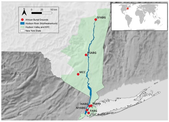
Figure 1.
Map of the study area, showing all seven ABG sites.
Historical Context: Slavery in Early New York
Despite the image calcified in the American public consciousness following the country’s civil war of American slavery as a “Southern scourge” (Pearce & Lee, 2021), slavery was a pillar of economic and social life in colonial and early national New York (Jackson et al., 2009).
The first enslaved Africans arrived in the area with the Dutch West India Company in 1627, three years after the inauguration of a new Dutch colony, “New Netherlands”, along the banks of the Hudson River (Jacobs, 2023). Most enslaved laborers in this early colonial period were owned by the Dutch West India Company directly. As a result, many white settlers from this time tended to view the local enslaved population as “company property”, not directly pertinent to their personal lives (Mosterman, 2021). The labor of the enslaved in these early years was thus directed mainly towards cultivating crops and building public infrastructure, particularly in New Amsterdam (i.e., future New York City on the island of Mannahatta), which was quickly becoming an important urban nexus for European colonial trade (Maika, 2020).2
However, as the colony grew (eventually changing its name to “New York”, following the transfer of colonial control to the English in 1664), the European settler population became more economically diverse, and the trade in enslaved people quickly gained prominence in other walks of life (Harris, 2004). According to the colony’s 1737 census, one in five New Yorkers was Black (1719 individuals out of 8666 total), and nearly all these Black New Yorkers were enslaved (Lepore, 2005). By the mid-eighteenth century, nearly half of all white households in New York City owned one or more enslaved individuals, indicating the extent to which slave ownership transcended social and economic boundaries among white colonists (White, 2012). Indeed, by the eighteenth century, New York City was second only to Charleston, South Carolina, in terms of proportion of enslaved individuals in its urban population. New York’s demographics were even known to elicit scorn from white European visitors because of the high level of visibility of enslaved people in virtually all public and private spaces (White, 1995). By this point, the work undertaken by enslaved New Yorkers had expanded to include a diverse constellation of industries, from shipbuilding and barrel making to gardening and homemaking (Harris, 2003; Mosterman, 2021). In other words, by the time New York ratified the United States Declaration of Independence in 1776, slavery had been embedded into the young state’s societal framework on various levels.
Notably, in the context of this study, New York’s early reliance on slavery meant that many white New Yorkers were also particularly paranoid about the prospect of slave rebellion (Sharples, 2020). Throughout New York, white authorities were keen to prevent unsupervised gatherings of the enslaved, particularly in visceral, emotional moments such as the death of a loved one. For this reason, local laws often severely restricted mourning rituals following the death of the enslaved, with no more than 12 people being allowed to attend any given funeral throughout New York during the eighteenth century (Diamond, 2006). This dynamic gives new meaning to the location of some of the sites discussed in this study and attests to the subtle resistance of the enslaved. The placement of the NYABG below the Collect Pond crevasse, for instance, or the location of the FABG outside the contemporary town limits, would have obscured these sites to non-community members and made it possible for the enslaved to reclaim some power over the law by physically stepping outside of the spaces where it was most intensely enforced.
2. Materials and Methods
2.1. The Sample
The full sample of sites considered in this survey is listed in Table 1 below. Table 1 also includes information about the historical preservation of each site from a cultural resource management perspective. This information is relevant to the discussion at the end of the article. The sites were selected following a review of the relevant literature available on Google Scholar, JSTOR and Google News, as well as the National Register of Historic Places and the New York City Landmarks Preservation Commission’s Archaeology Reports catalog. For the purposes of this study, sites were only considered if their use history was known to terminate within three decades (i.e., roughly one generation) of emancipation in New York in 1827. This was implemented in order to avoid the methodological problems posed by more recent sites, where early twentieth-century burials and other modifications tend to result in complicated palimpsests, making it difficult to discern archaeological differences between the post-emancipation and pre-emancipation landscapes. One example of this is the African American burial ground at 47-11 90th St in Elmhurst, Queens, which has recently been the subject of media attention (Laterman, 2019). While the deed to the land was only acquired by the local Black community in 1828, a year after state emancipation, it has been suggested that enslaved individuals had been burying their dead there for several decades before that date (Sanjek, 2000). Furthermore, a recent newspaper article suggests that remains from several of the individuals buried there (potentially including remains from both pre- and post-emancipation burials) were likely disinterred and moved to an active cemetery elsewhere in Queens in 1927, following the sale of the burial ground and adjacent African Methodist Episcopal church building to developers in the late 1920s (Laterman, 2019). Complicated histories like this one are undoubtedly worth investigation and analysis and would likely benefit from survey and potentially even excavation in collaboration with descendant communities. However, such palimpsests also pose questions beyond the scope of the current study, which aims to focus specifically on the idea of the African Burial Ground as a final resting place for the enslaved.
Of all seven African Burial Ground sites considered in the sample, the NYABG in Lower Manhattan is by far the largest, with an estimated total of about 15 thousand individuals buried there (Frohne, 2015; Figure 2). This is partly because it is also the closest of all sites in the sample to the “ground zero” of the transatlantic slave trade in New York, in the sense of its proximity to the slave trading vessels that came and went from New York Harbor. Data from the Transatlantic Slave Trade Database (Radburn, 2023) suggest that during the seventeenth and eighteenth centuries, several thousand enslaved individuals entered the harbor at the East River slips, less than one kilometer away from the NYABG (Hodges, 2005). Indeed, at the peak of the New York slave trade in the eighteenth century, a large slave market also existed less than a kilometer from the NYABG on Wall Street, where enslaved individuals could be bought and sold at auction (Moore, 2005). In addition to its size, the NYABG is also the most thoroughly excavated site in the sample and, therefore, provides perhaps the clearest picture archaeologically. In a historic salvage excavation precipitated by years of community organizing, osteological remains from a total of 419 individuals were excavated from the site in the early 1990s (Jackson et al., 2009). The demographics of this sample of 419 individuals reflect the Burial Ground’s proximity to the slave ships of New York Harbor, with evidence suggesting that a sizable number of individuals among those exhumed were born and raised in western Africa and likely experienced the Middle Passage themselves. For instance, 26 NYABG individuals show clear evidence of cultural tooth modifications known to have been practiced among historic cultural groups in Africa and the Caribbean—a record high among African-descended skeletal samples in the United States (Goodman et al., 2009). Throughout the history of slavery in North America, there was always a strong continuity between cultural practices in West Africa and those preserved by enslaved African-descended communities on the other side of the Atlantic (Janzen, 2017). Thus, the presence of cultural tooth modifications should not necessarily be taken as a guarantee that an individual was born in Africa rather than the Americas. However, strontium isotope ratios and elemental signature analysis revealed that most of the 26 individuals from the NYABG population with culturally modified teeth did indeed probably spend time in West Africa during their childhoods (Goodman et al., 2009).
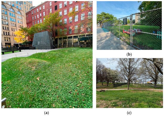
Figure 2.
Selected ABGs from the sample: (a) the NYABG; (b) the FABG; (c) the Hunts Point ABG. All photographs by the author.
The FABG, in modern-day Brooklyn, is believed to have been established in the late seventeenth century, perhaps on farmland owned by the Stryker family (Kearns & Schneiderman-Fox, 2000). Although within New York’s modern-day city limits, Flatbush had not yet been incorporated into New York City during the eighteenth and early nineteenth centuries and would likely have felt much farther removed from the slave markets of Manhattan than the NYABG (Buis, 2011). Salvage excavations at a historic schoolhouse abutting the FABG site in 2001 resulted in the recovery of teeth and cranial fragments from two individuals (Schneiderman-Fox et al., 2001). While these remains offer little demographic data, an 1810 obituary for an enslaved woman named Eve in the Long Island Star explicitly mentions a funeral held for her at the FABG (FABG Remembrance and Redevelopment Task Force, 2021). This suggests that burial ceremonies at the site were at least somewhat known to the Star’s readership, which would likely have included many of Flatbush’s white residents.
The Harlem African Burial Ground (HABG) was in use from the mid-seventeenth to the mid-nineteenth century (Pappalardo & Meade, 2016). The majority of the site is currently situated beneath a New York City Metropolitan Transit Authority bus depot, at the intersection of First Avenue and 126 Street in Manhattan, overlooking the Harlem River. The HABG likely originated as part of a larger cemetery founded by the nearby Reformed Low Dutch Church of Harlem in 1668 (Pappalardo & Meade, 2016). However, when the Dutch Church moved roughly 0.5 km south in 1686, less than two decades after its founding, historical maps suggest that enslaved people and their descendants continued to use the original site (Tilton, 1910). Excavations at the site in 2015 revealed that much of the sediment has been mixed or otherwise disturbed, likely during the landfilling of the Harlem River shoreline in the late nineteenth century (Pappalardo & Meade, 2016). In recent years, the poor preservation and heavily developed urban setting have made studying the burial ground population difficult. However, detailed documentation and historical maps nonetheless make it possible to consider the HABG from the perspective of physical and cultural geography, which the latter part of this study aims to do.
Meanwhile, the Hunts Point Enslaved African Burial Ground (henceforth referred to as Hunts Point or the Hunts Point ABG) is one of two ABG sites in the sample that is known to have been connected to a single white family estate rather than a city or town. Namely, the Hunts Point ABG was established on land owned by the Hunt family, one of the Bronx’s most prominent landholding families throughout the eighteenth century (Caratzas, 2023). The Hunts ABG was located less than 100 m away from the joint Hunts–Willett–Leggett cemetery, which was used to bury members of those three landowning families. However, the nearby ABG was likely used primarily as a burial ground for enslaved people owned by the Hunt family in particular (Caratzas, 2023). For this reason, it is much smaller and contains fewer burials than most of the other ABGs in the sample. Headstones and colonial documents indicate that the Hunts–Willett–Leggett cemetery was created in the 1720s; historians believe the Hunts Point ABG came into use around the same time (MacLean et al., 2017). Both were likely in use until the Hunt family estate was broken up into smaller holdings following abolition in New York in the nineteenth century (Caratzas, 2023). A ground penetrating radar (GPR) survey of the site in 2016 revealed four human burials, all of which appear to be oriented in the north–south direction (Rothschild et al., 2022). This orientation differs from all of the several hundred excavated graves in the NYABG and does not align with common Christian burial practice at the time, which typically mandated an east–west burial orientation (MacLean et al., 2017). It raises the possibility that the individuals buried at the Hunts Point ABG did not view themselves as Christian. Whether or not this was true, the orientation of the four burials detected by GPR nonetheless alludes to the religious diversity of enslaved African communities throughout North America (Halverson, 2016), as well as the preservation of African-origin religious and cultural practices in the Americas by the enslaved.
The African Burial Ground in Montgomery, New York, has gone by several names over the years, including the Montgomery Colored Cemetery (historically), the Montgomery African Burial Ground (colloquially), and more recently, the Montgomery African American Burial Ground. Similar to the majority of ABGs in the sample, it served the entire town of Montgomery, New York, rather than the enslaved individuals owned by a single settler family or estate. One archaeologist has estimated that as many as 500 individuals are buried there based on relative dating, magnetometry and GPR surveys (Sandy, 2024). The earliest burial has been dated to 1756 via an inscribed headstone; it is estimated that the burial ground fell into disuse sometime in the second half of the nineteenth century, in the decades directly following emancipation (Leach, 2020). As one scholar has recently pointed out (Sandy, 2024), the inclusion of the word “Colored” in the site’s historic toponym, while anachronistic by modern standards, hints at potential diversity within the burial ground population. The racial category “colored” in New York in the eighteenth century would often have included Indigenous and multi-ethnic individuals, as well as African-descended ones (Feller, 2022; Starr, 2023). While the use of the site to bury enslaved African-descendant individuals has been historically documented, a strong possibility exists that the community that used the site included cultures beyond the African diaspora as well.
Similar to several other sites in this sample, the Pine Street African Burial Ground (PSABG) in Kingston, New York, appears on several colonial maps between the mid-seventeenth and early nineteenth centuries, suggesting at least a vague awareness of its existence amongst white colonial cartographers (Diamond, 2006). It likely emerged sometime shortly after Kingston’s founding as a place for the town’s enslaved and African-descendant communities to bury their dead and remained in use until the decades after New York abolition, when Kingston’s white residential neighborhoods began to encroach on the burial ground, and a white family eventually purchased the land to build a house there in 1853 (Diamond, 2006). A recent GPR survey published in the gray literature as a report to the New York State Historic Preservation Office revealed several dozen graves oriented in both the east–west and north–south directions, with some graves overlying one another, suggesting multiple phases of burials (Woods, 2019).
The African Burial Ground at Schuyler Flatts, often referred to simply as the Schuyler Flatts Burial Ground (SFBG or SFABG), is similar to the Hunts Point ABG in the sense that it was tied to the estate of a single white slave-owning family. This family was the Schuylers, one of early New York’s most prominent settler families, and the SFABG was likely devoted entirely to the community that arose surrounding the enslaved individuals whom the Schuylers owned. The SFABG is the only burial ground in the sample to have been completely excavated, and a thorough picture is thus available of its population. Only fourteen individuals were buried there (notably all oriented north–south), including infants, children and adults (Lee et al., 2009). Relative dating of burial artifacts suggests that interments began in the mid-eighteenth century and continued through the early nineteenth century (Anderson, 2009). Mitochondrial DNA analysis of remains from seven of the individuals revealed that four were descended from mainland Africa, while two belonged to a haplogroup common today among Malagasy people, and one belonged to haplogroup X2, typically associated with Indigenous American communities, particularly the Mi‘kmaq people of eastern Canada (Lee et al., 2009). Similar to the term “colored” in the Montgomery ABG’s historical toponym, these genetic data hint at the diversity of the communities that utilized (and quite literally constitute) New York’s African Burial Grounds.
2.2. Data Collection
Most of the GIS analyses conducted for this study were centered around contemporary 30 m resolution NASA digital elevation models (NASADEMs), downloaded as rasters from opentopography.org, an open-access remote sensing data repository. In the cases of the NYABG, the Hunts Point ABG and the HABG, eighteenth- and nineteenth-century topographic maps were available that included the areas surrounding each of those ABGs (Figures S1–S3). Such maps predated much of the urban development that has overtaken those three sites in the last century and, therefore, provided a more accurate picture of the historical topography than the NASADEM rasters, which are all based on remote sensing data collected in the last 30 years. While limited information about the datum points used in the historical maps made it difficult to calculate exact differences between the historical elevations and those provided in the NASADEM rasters, the historical maps were still used to assess the accuracy of elevation relationships between different points in the DEM, relative to each other. In places where a discrepancy of more than 5 m was found, the pixels in the DEM were edited by hand using the Serval plugin in QGIS to more accurately reflect the pre-twentieth-century topography described in the historical map.
It should be noted that all three historical maps examined were created from a white colonial perspective and include minimal detail about the ABG and its direct environs. Such maps must be used critically and with caution in order to avoid perpetuating the colonial epistemologies and power dynamics embedded within them (Brückner, 2021). However, their usage in this study has been limited to that of simply checking historical topography, primarily as a safeguard against the risks that come with using diachronous remote sensing data in archaeological analyses.
While historical topographic maps of equivalent quality were not available for the other four sites in the sample, the other sites (with the possible exception of the FABG) have all undergone significantly less urban development than the NYABG, Hunts Point and the HABG and were deemed to pose a reduced risk of compromising the GIS analysis through their NASADEM elevations. Of course, this does not mean that the DEMs used in the study reflect historical reality with full accuracy. While the topography of southeastern New York State has not been particularly volatile over the past four centuries (Nitsche et al., 2007), all seven of the sites in the sample have undoubtedly experienced some level of topographic change due to erosion, sedimentation and other natural Earth surface processes, to say nothing of anthropogenic modification. Dealing with such change and accounting for the associated inaccuracies is a perennial dilemma for archaeologists conducting GIS analysis (Becker et al., 2017). However, in this case, the modifications made to the DEMs for the NYABG, Hunts Point and the HABG were deemed to be sufficient corrective action.
In addition to DEMs, soil and hydrological data were also downloaded for each site from websoilsurvey.usda.gov, a publicly accessible web portal managed by the United States Department of Agriculture (USDA) for the purpose of viewing data from the USDA’s Soil Survey Geographic Database (SSURGO, 2025).
Meanwhile, the approximate geographic extent of each ABG was drawn out by hand as a polygon shapefile in QGIS, based on the available literature and historical maps. The same was performed for the white Christian cemetery that would have been closest to each of the seven ABGs during pre-emancipation times (see Table S1 for the full list of white Christian cemeteries used for comparison). This was implemented in order to allow for the comparison of the ABGs with an outgroup, under the thinking that the nearby white burial spaces would have existed on the same landscapes, under equivalent environmental and historical conditions, but would have operated under vastly different power dynamics. Distances between the ABGs and their white Christian counterparts were assessed in QGIS using Euclidean distance. However, all seven of the white cemeteries considered in the study would likely also have been the closest white cemeteries to their ABG counterparts, not just in terms of Euclidean distance but also from the perspective of lived human experience in terms of travel time and proximity between communities. As discussed in the introduction above, this methodology draws on the idea of space as a social construct, shaped by quotidian actions at the micro level and societal power relations at the macro level (Löw, 2016).
Once acquired, all shapefiles, rasters and other data were loaded into a single QGIS model and projected using a WGS 84 UTM Zone 18N projection (EPSG:32618). This projection was chosen because it centers New York and minimizes warping and measurement error in visualizations, distance measurements and other analyses performed using coordinate points within the region.
2.3. Analysis
Slope rasters were calculated from each DEM in QGIS. Rasters describing the visibility from each pixel in the DEMs were also calculated in QGIS using the “visibility index” plugin (Zoran, 2020). The plugin samples the viewshed from each pixel for a 1.6 m tall observer along 16 equally spaced lines of sight, with an atmospheric refraction of k = 0.13, accounting for Earth curvature. The resulting index ranges from 0 to 1, with 0 indicating that no points along any of the 16 sample lines are visible from the point of origin and 1 indicating 100 percent visibility. Summary statistics (including maximum, minimum, mean and standard deviation) were then calculated for each burial ground and cemetery polygon to describe their elevation, slope and visibility indices.
Finally, summary statistics were also calculated within the bounds of each polygon for the two measures from the SSURGO data deemed to be most insightful to the questions under consideration. Specifically, two SSURGO measures were selected based on their relevance to understanding the way human remains might decompose or preserve at burial sites. The first of these was average water storage to 150 cm (AWS). This is the volume of water in cm3 that the soil can store that is available to plants. It is effectively a measure of soil moisture. The second was the representative mean annual precipitation (MAP), expressed in mm of rainfall. Both of these measures were calculated using data collected between 1961 and 1990 (SSURGO, 2025). These measures were selected under the thinking that they might help understand the sites’ geomorphologies, if only from a qualitative perspective, given the relatively low spatial resolution and the small sample size.
The data resulting from all the summary statistics mentioned above are described in Table 2.
Table 2.
The measures considered for each of the sites in the GIS analyses.
3. Results
The sample of sites considered in this study is modest in size and allows for limited conclusions and extrapolations. However, given that the sample is nonetheless taken to be representative of the study region, it is still possible to elucidate some truths from patterns within these seven sites, despite the small sample size (Ember & Ember, 2001). While archaeological context is helpful for understanding the nuanced positionalities of the individuals buried at each site, the data collected from the GIS analyses described above allows for each site to be viewed as a single, cohesive space, making it easier to compare African Burial Grounds to contemporary white colonial burial spaces.
Spatial differences and similarities between the ABGs and the nearest white Christian cemeteries are visualized in Figure 3. While the visibility of ABGs on the landscape appears to be similar to that of their nearby white counterpart spaces (Figure 3c), there is a noticeable difference between the two groups in average elevation and slope, with the white cemeteries consistently situated in more elevated, more steeply graded locations than the ABGs. In the case of slope in particular, a two-sample t-test reveals a statistically significant difference between ABGs and white cemeteries within the sample (t = −2.93, p = 0.03), with the mean slope across all ABG sites being 2.25 degrees (i.e., nearly flat) and the mean slope across all white cemeteries being 14.07 degrees (i.e., noticeably graded).
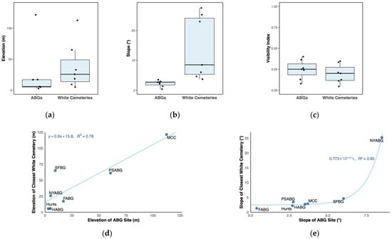
Figure 3.
Understanding spatial data: (a–c) boxplots showing the distribution of average elevation, slope and visibility index values within the African Burial Grounds compared to the distribution of the same values within the nearest white cemeteries to each site; (d,e) scatter plots comparing elevation (d) and slope (e) between the African Burial Grounds and the nearest white cemeteries, as well as regression lines modeling the relationship between the African Burial Grounds and white cemeteries.
The result of a two-sample t-test between the two groups remained significant when elevation and slope were combined into a single measure (t = 11.08, p = 0.01). This combination was performed by creating a single least discriminant axis via linear discriminant analysis (LDA), using the mean elevation and slope values for each site. In this way, each site received a single combined LDA axis score for both elevation and slope. The strong difference between the mean LDA axis value of the white cemeteries compared to that of the ABGs suggests that while the difference in elevation alone between the two types of burial grounds is not statistically significant in such a small sample, elevation is nonetheless part of a set of more complex, emergent properties of landscape that differ significantly between ABGs and their white counterparts. By extension, it may also be suggested that elevation and slope are part of what defines the unique geography of the African Burial Grounds in New York City and the Hudson Valley.
Such a prospect raises further questions about the preservation of human remains and allows for the thanatology of these places to be considered from the perspective of fluid dynamics, erosion and other aspects of geomorphology. While the spatial resolution of the SSURGO data is too coarse to infer the occurrence of specific geomorphological processes at individual sites, it is likely that topographic differences between the lower-elevation, flatter environments of the ABGs and the higher-elevation, more steeply graded white cemeteries would have resulted in hydrological differences as well. AWS and precipitation are both part of a broader network of hydrological variables that impact and are impacted by the soil microbiota and, by extension, the chemical decomposition of buried bodies (Wescott, 2018). While the hydrological measures in this study were purely qualitative, future fieldwork could provide a more precise account of the way that the topographic patterns described in this study impacted the decomposition conditions at the ABGs and thereby the physical afterlives of the individuals buried there.
Patterns in elevation and slope amongst ABGs also allow for generalization, as demonstrated by the regression models depicted in Figure 3d,e. Based on the sample of sites examined, the elevation of ABGs is correlated to the elevation of the nearest historical white cemeteries (and vice versa) in a linear equation with an R2 of 0.78. Meanwhile, the slope of ABGs is correlated to the slope of the nearest historical white cemeteries via an exponential equation, with an even higher R2 of 0.95.
4. Discussion
Before discussing the results described above, it is worth pausing to acknowledge that the use of GIS (and predictive GIS modeling, specifically) in the context of the archaeology of slavery is a fraught proposition. Like all cartographic endeavors in archaeology, GIS analyses create a facsimile of historical reality that should be taken neither as truth nor as a mandate to comment freely on the behavior and perspective of enslaved individuals, who were active and free-willed historical agents in the creation of the archaeological record. However, when used with empathy, caution and precision, GIS-based modeling exercises have the potential to be an important tool in the preservation of Black cultural heritage. For example, multiple New York ABG sites have come under threat of destruction or disappearance in recent decades due to construction and development (see the “State of Archaeological Preservation” column in Table 1). The NYABG in Lower Manhattan was almost completely destroyed during the construction of a government building on the site in the early 1990s (Frohne, 2015); meanwhile, the FABG in Brooklyn recently came under threat of destruction as part of the construction of new affordable housing in the area (FABG Remembrance and Redevelopment Task Force, 2021). In those cases, the preservation of the site (and the commemoration of the history it represents) relied on a unified, often labor-intensive grassroots response from the local African American community (Diamond, 2006; Matthews, 2020). What if, in the future, such community responses could be underpinned by a comparative archaeological framework that contextualizes each site within the broader tradition of African Burial Grounds throughout southeastern New York State? The data presented in Figure 3, as well as the rest of the information presented in this study, could enable such a framework and perhaps even allow for the proactive identification of ABG sites in New York by administrative bodies such as the New York City Department of Parks and Recreation before such sites come under threat of destruction. There have been ongoing efforts by lawmakers on New York City’s Council to establish a formal process for identifying and preserving African American Burial Grounds throughout the city (with particular heed towards African Burial Grounds). These efforts recently culminated in a legislative proposal which, if passed, would establish a register of African (and African American) Burial Grounds throughout the city (The New York City Council—File #: Int 1051-2024, Int No 1051-2024, New York City Council, 2024). Certainly, as several Indigenous scholars and their allies have pointed out in Canada, Oceania, and elsewhere, such registries and databases only have a positive impact when their use is guided by clear ethical principles that prioritize descendant communities in the decision-making process (Gupta et al., 2020; Smith, 2016). However, if it were to be paired with such principles, the City Council’s proposed ABG registry could be taken as a blueprint for how to defend against the erasure of African American cultural resources in southeastern New York State and beyond. The data, analyses and theoretical framework presented in this article could be incorporated into such a registry and future legislation with fruitful results. Indeed, in Hong Kong, recent scholarship suggests that a similar comparative approach to the one taken in this article, when integrated with genealogical research methods and a highly localized comparative GPR analysis of individual gravesites, can even enable descendant communities to uncover previously unknown genealogical connections (Kwan & Lai, 2024). Furthermore, when paired with low-cost remote sensing methods, like those employed by the researcher Stephanie Spera and her colleagues (Spera et al., 2022), intra-regional comparative approaches, such as the one in this article, can be used to expand knowledge of individual burial grounds, allowing for more detailed comparative mortuary analysis and a better understanding of burial ground populations (Parditka & Duffy, 2023).
5. Conclusions
In addition to modern cultural heritage management applications, however, the information and findings presented in this article also make it possible to comment on the article’s initial thesis, namely, that despite representing a variety of lived economic, domestic and ecological experiences, New York’s ABGs are nonetheless united by a common spatial dialectic, which validates the use of the term “African Burial Ground” to refer to a single, spatial-historical phenomenon.
On the one hand, the unique archaeological contexts of each of the seven sites considered in this study paint very different pictures of life, death, mourning and remembrance amongst communities of the enslaved and their descendants throughout New York history. The archaeology of the NYABG and the SFABG showcases the ethnic and cultural diversity of New York’s enslaved populations. Meanwhile, functional differences between the FABG, HABG, the Hunts Point ABG and the MCC arising from differences between their historical contexts reveal the diverse ways that lived experiences of religion, labor and other elements of life reflected themselves in the burial of the deceased. On the other hand, the intra-regional comparative approach taken in this article reveals that all of the burial spaces considered here are united by a common spatial dialectic, defined by similar geographic relationships to nearby contemporary white burial spaces. In that sense, to answer the question posed by the Richard Wright haiku in this article’s epigraph, the metaphorical melody of New York’s African Burial Grounds could not, in fact, be sung “in other countries, by other birds”. To extend Wright’s metaphor, it is the “country” (i.e., the land) itself that is responsible for the rhythm of the song. New York’s physical geography is an inherent historical feature of the region’s African Burial Grounds.
Supplementary Materials
The following supporting information can be downloaded at https://www.mdpi.com/article/10.3390/humans5040025/s1, Figure S1: Topographic map of New York African Burial Ground site; Figure S2: Topographic map of Westchester County; Figure S3: Map of Harlem African Burial Ground site; Table S1: Historical white Christian cemeteries used for comparison. References (Danylchak & Cothran, 2018; New York Genealogical & Biographical Society, 1982; Stiles, 2012; U.S. General Services Administration, 1993; Williams, 1999) are cited in the supplementary materials.
Funding
This research received no external funding.
Institutional Review Board Statement
Not applicable.
Informed Consent Statement
Not applicable.
Data Availability Statement
The original contributions presented in this study are included in the article/Supplementary Materials. Further inquiries can be directed to the corresponding author.
Conflicts of Interest
The author declares no conflicts of interest.
Abbreviations
The following abbreviations are used in this manuscript:
| ABG | African Burial Ground |
| DEM | Digital elevation model |
| GPR | Ground penetrating radar |
Notes
| 1 | Take, for instance, the bioarchaeologist Aja Lans for a discussion of the dual role of the skeleton as both “object” and “subject” in bioarchaeological research (Lans, 2018). |
| 2 | Wall Street’s eponymous wall, for example, was constructed mainly by enslaved Africans under the ownership of the Dutch West India Company in 1653 (Moore, 2005). |
References
- Anderson, L. (2009). Update on the Schuyler Flatts burial ground. Legacy: The Magazine of the New York State Museum, 5(1). Available online: https://www.nysm.nysed.gov/research-collections/archaeology/bioarchaeology/research/schuyler-flatts-burial-ground (accessed on 15 December 2024).
- Armstead, M. B. Y. (2003). Mighty change, tall within: Black identity in the Hudson Valley. SUNY Press. [Google Scholar]
- Becker, D., De Andrés-Herrero, M., Willmes, C., Weniger, G.-C., & Bareth, G. (2017). Investigating the influence of different DEMs on GIS-based cost distance modeling for site catchment analysis of prehistoric sites in Andalusia. ISPRS International Journal of Geo-Information, 6(2), 36. [Google Scholar] [CrossRef]
- Brückner, M. (2021). Colonial counter-mappings and the cartographic reformation in eighteenth-century America. XVII–XVIII. Revue de La Société d’études Anglo-Américaines Des XVIIe et XVIIIe Siècles, 78, 78. [Google Scholar] [CrossRef]
- Buis, A. M. (2011). Dutch New York between east & west: The world of Margrieta van Varick. Material Culture Review, 73, 68–77. [Google Scholar]
- Caratzas, M. D. (2023). Joseph Rodman Drake Park and enslaved people’s burial ground (Designation report LP-2674). New York City Landmarks Preservation Commission.
- Danylchak, E., & Cothran, J. R. (2018). Grave landscapes: The nineteenth-century rural cemetery movement. University of South Carolina Press. Available online: https://muse.jhu.edu/pub/244/monograph/book/57039 (accessed on 7 July 2025).
- Deicke, A. (2024, April 8). Spaces of funeral meaning: Modelling socio-spatial relations in burial contexts. CAA 2023—“50 Years of Synergy”. Zenodo. [Google Scholar] [CrossRef]
- Diamond, J. E. (2006). Owned in life, owned in death: The Pine Street African and African-American burial ground in Kingston, New York. Northeast Historical Archaeology, 35(1), 47–62. [Google Scholar] [CrossRef][Green Version]
- Ember, C. R., & Ember, M. (2001). Cross-cultural research methods. Bloomsbury Publishing PLC. [Google Scholar]
- FABG Remembrance and Redevelopment Task Force. (2021). Bedford-church community engagement report. New York City Department of Housing Preservation and Development. Available online: https://www.nyc.gov/assets/hpd/downloads/pdfs/services/bedford-church-report.pdf (accessed on 20 July 2025).
- Feller, L. J. (2022). Being indigenous in Jim Crow Virginia: Powhatan people and the color line. University of Oklahoma Press. Available online: https://muse.jhu.edu/pub/350/oa_monograph/book/101132 (accessed on 9 July 2025).
- Frohne, A. E. (2015). The African burial ground in New York city: Memory, spirituality, and space. Syracuse University Press. [Google Scholar]
- Goldstein, L. (1981). One-dimensional archaeology and multi-dimensional people: Spatial organisation and mortuary analysis. In R. Chapman, I. Kinnes, & K. Randsborg (Eds.), The archaeology of death (pp. 53–69). Cambridge University Press. Available online: https://d1wqtxts1xzle7.cloudfront.net/48236155/Goldstein_1981-libre.pdf?1471899527=&response-content-disposition=inline%3B+filename%3DOne_dimensional_archaeology_and_multi_di.pdf&Expires=1755557955&Signature=dDXvaM0GTaSZwDc1eBUp0rs5h1W5DF5gMXFrMysmb2GaL32HsN8riPT-T0skpH6OFlj4dcowfS78bl75vs7W1XhHEMZ-YUsM38d58bMjOK3N6nL0M1wJ~iUXh5sRtAePGtSJpic3xSIDJkJdCS3kESaHEs1MpC9JBhWau7HRtDnjpCbw8qG1pRRYF3GGGgyVKP44QLlNvohJe7-z865gCpBKs6~4xhVT35zJXn3jRfyssuKJwDIB2M1UUymBx~kVKqneahDGEpGOLxIYpSi4E3Eysv00fJtmWt8ry6kMP4~qI5x0FTYa6tLE54CU8nQd~m9EihuZGOMdxaXNoHI5ug__&Key-Pair-Id=APKAJLOHF5GGSLRBV4ZA (accessed on 20 July 2025).
- Goodman, A. H., Jones, J., Reid, J., Mack, M. E., Blakey, M. L., Amarasiriwardena, D., Burton, P., & Coleman, D. (2009). Isotopic and elemental chemistry of teeth: Implications for places of birth, forced migration patterns, nutritional status, and pollution. In M. L. Blakey, & L. M. Rankin-Hill (Eds.), The skeletal biology of the New York African burial ground (Vol. 1, pp. 95–118). Howard University Press. [Google Scholar]
- Gupta, N., Blair, S., & Nicholas, R. (2020). What we see, what we don’t see: Data governance, archaeological spatial databases and the rights of indigenous peoples in an age of big data. Journal of Field Archaeology, 45(Supp. 1), S39–S50. [Google Scholar] [CrossRef]
- Halverson, J. R. (2016). West African Islam in colonial and antebellum South Carolina. Journal of Muslim Minority Affairs, 36(3), 413–426. [Google Scholar] [CrossRef]
- Harris, L. M. (2003). Slavery in colonial New York. In In the shadow of slavery: African Americans in New York city, 1626–1863 (pp. 11–47). University of Chicago Press. Available online: http://archive.org/details/inshadowofslaver0000harr (accessed on 8 July 2025).
- Harris, L. M. (2004). Slavery, emancipation, and class formation in colonial and early national New York city. Journal of Urban History, 30(3), 339–359. [Google Scholar] [CrossRef]
- Hodges, G. R. G. (2005). Root and branch: African Americans in New York and East Jersey, 1613–1863. University of North Carolina Press. [Google Scholar]
- Jackson, F. L., Mayes, A., Mack, M. E., Froment, A., Keita, S. O., Kittles, R. A., George, M., Shujaa, K. J., Blakey, M. L., & Rankin-Hill, L. M. (2009). Origins of the New York African burial ground population: Biological evidence of geographical and macroethnic affiliations using craniometric, dental morphology, and preliminary genetic analyses. In M. L. Blakey, & L. M. Rankin-Hill (Eds.), The skeletal biology of the New York African burial ground (Vol. 1, pp. 69–94). Howard University Press. [Google Scholar]
- Jacobs, J. (2023). The first arrival of enslaved Africans in New Amsterdam. New York History, 104(1), 96–114. [Google Scholar] [CrossRef]
- Janzen, J. M. (2017). African religion and healing in the Atlantic Diaspora. Oxford Research Encyclopedia of African History, 44–65. [Google Scholar] [CrossRef]
- Kearns, B., & Schneiderman-Fox, F. (2000). Stage 1A archaeological assessment, Bath Rivka School, Flatbush, Brooklyn, New York (Archaeological report 857). New York City Landmarks Preservation Commission. Available online: http://s-media.nyc.gov/agencies/lpc/arch_reports/857.pdf (accessed on 12 December 2024).
- Kwan, R. L.-Y., & Lai, W. W.-L. (2024). Archaeological investigation of burials preluded by ground penetrating radar and geospatial technologies. Journal of Archaeological Science, 170, 106058. [Google Scholar] [CrossRef]
- Lans, A. (2018). “Whatever was once associated with him, continues to bear his stamp”: Articulating and dissecting George S. Huntington and his anatomical collection. In P. K. Stone (Ed.), Bioarchaeological analyses and bodies: New ways of knowing anatomical and archaeological skeletal collections (pp. 11–26). Springer International Publishing. [Google Scholar] [CrossRef]
- Laterman, K. (2019, June 14). This empty lot is worth millions. It’s also an African-American burial ground. The New York Times. Available online: https://www.nytimes.com/2019/06/14/nyregion/african-american-burial-ground-queens-newtown.html (accessed on 15 December 2024).
- Leach, O. (2020, August 20). Historic African American cemetery in montgomery to be restored. Spectrum News. Available online: https://spectrumlocalnews.com/nys/hudson-valley/news/2020/08/20/town-of-montgomery-establishes-committee-to-revitalize-historic-african-american-cemetery (accessed on 9 July 2025).
- Lee, E. J., Anderson, L. M., Dale, V., & Merriwether, D. A. (2009). MtDNA origins of an enslaved labor force from the 18th century Schuyler Flatts Burial Ground in colonial Albany, NY: Africans, native Americans, and Malagasy? Journal of Archaeological Science, 36(12), 2805–2810. [Google Scholar] [CrossRef]
- Leitner, J. (2016). Transitions in the colonial Hudson Valley: Capitalist, Bulk Goods, and Braudelian. Journal of World—Systems Research, 22(1), 214–246. [Google Scholar] [CrossRef]
- Lepore, J. (2005). The tightening vise: Slavery and freedom in British New York. In I. Berlin, & L. M. Harris (Eds.), Slavery in New York (pp. 57–90). The New Press. [Google Scholar]
- Löw, M. (2016). The sociology of space: Materiality, social structures, and action (2nd ed.). Palgrave Macmillan US. Available online: https://content.e-bookshelf.de/media/reading/L-8096072-bf5130e0f8.pdf (accessed on 18 August 2025).
- MacLean, J. S., Conyers, L., & Ottman, S. M. (2017). Hunts Point Burial Ground, Drake Park, Bronx, New York (Phase 1A Documentary Study and Ground Penetrating Radar Survey 1744). New York City Landmarks Preservation Commission.
- Maika, D. J. (2020). To “experiment with a parcel of negros”. Journal of Early American History, 10(1), 33–69. [Google Scholar] [CrossRef]
- Matthews, C. N. (2020). Urban erasures: Historical and contemporary archaeologies. Journal for the Anthropology of North America, 23(1), 4–11. [Google Scholar] [CrossRef]
- Moore, C. P. (2005). A world of possibilities: Slavery and freedom in Dutch New Amsterdam. In I. Berlin, & L. M. Harris (Eds.), Slavery in New York (pp. 29–55). The New Press. [Google Scholar]
- Mosterman, A. C. (2021). Spaces of enslavement: A history of slavery and resistance in Dutch New York. Cornell University Press. [Google Scholar]
- New York City Council. (2024). The New York City Council—File #: Int 1051-2024, Int No 1051-2024. Available online: https://legistar.council.nyc.gov/LegislationDetail.aspx?ID=6874636&GUID=8C163699-6A3D-4733-BB10-90F7118DB2BD&Options=&Search= (accessed on 30 June 2025).
- New York Genealogical & Biographical Society. (1982). Kingston, New York, Old Dutch Church: Burials 1810–1815 (Vol. 113). NYG&B Record. Available online: https://www.newyorkfamilyhistory.org/online-records/nygb-record/566-568/9 (accessed on 7 July 2025).
- Nitsche, F. O., Ryan, W. B. F., Carbotte, S. M., Bell, R. E., Slagle, A., Bertinado, C., Flood, R., Kenna, T., & McHugh, C. (2007). Regional patterns and local variations of sediment distribution in the Hudson River Estuary. Estuarine, Coastal and Shelf Science, 71(1), 259–277. [Google Scholar] [CrossRef]
- Pappalardo, A. M., & Meade, E. D. (2016). Phase 1B archaeological investigation, 126th Street Bus Depot: Block 1803, Lot 1, East Harlem, New York, New York (Phase 1B archaeological investigation 15PR02521; p. 156). New York City Economic Development Corp. [Google Scholar]
- Parditka, G., & Duffy, P. R. (2023). From the ashes of Bronze Age fires: A framework for comparison across body treatments. Journal of Anthropological Archaeology, 71, 101525. [Google Scholar] [CrossRef]
- Pearce, S. C., & Lee, R. (2021). Missing colonies in American myths of slavery: Where is the “Deep North” in sociology textbooks? Sociology of Race and Ethnicity, 7(4), 579–593. [Google Scholar] [CrossRef]
- Radburn, N. (2023). Trans-Atlantic slave trade database. Slave Voyages. Available online: https://www.slavevoyages.org/voyage/database (accessed on 20 September 2024).
- Rothschild, N. A., Sutphin, A., Bankoff, H. A., & MacLean, J. S. (2022). Buried beneath the city: An archaeological history of New York. Columbia University Press. [Google Scholar] [CrossRef]
- Sandy, W. (2024). Archaeology of the montgomery “Colored” cemetery (p. 6). Walden Juneteenth Celebration. [Google Scholar]
- Sanjek, R. (2000). The future of us all: Race and neighborhood politics in New York city. Cornell University Press. [Google Scholar]
- Schneiderman-Fox, F., Crist, T., Dickinson, N., Kearns, B., Mascia, S., & Saunders, C. (2001). Stage 1B archaeological investigation, P.S. 325-K, Church and Bedford Avenues, Brooklyn, New York (Archaeological report 858). New York City Landmarks Preservation Commission.
- Sharples, J. T. (2020). The world that fear made: Slave revolts and conspiracy scares in early America. University of Pennsylvania Press. [Google Scholar]
- Smith, D. E. (2016). Governing data and data for governance: The everyday practice of Indigenous sovereignty. In T. Kukutai, & J. Taylor (Eds.), Indigenous data sovereignty: Toward an agenda. ANU Press. [Google Scholar] [CrossRef]
- Spera, S. A., Franklin, M. S., Zizzamia, E. A., & Smith, R. K. (2022). Recovering a Black cemetery: Automated mapping of hidden gravesites using an sUAV and GIS in east end cemetery, Richmond, VA. International Journal of Historical Archaeology, 26(4), 1110–1131. [Google Scholar] [CrossRef]
- SSURGO. (2025). SSURGO [Dataset]. Available online: https://websoilsurvey.sc.egov.usda.gov/App/HomePage.htm (accessed on 9 July 2025).
- Stanne, S. P., Panetta, R. G., Forist, B. E., & Niemisto, M. L. (2021). The Hudson: An illustrated guide to the living river (3rd ed.). Rutgers University Press. [Google Scholar] [CrossRef]
- Starr, P. (2023). The Re-Emergence of “People of Color”. Du Bois Review: Social Science Research on Race, 20(1), 1–20. [Google Scholar] [CrossRef]
- Stiles, H. (2012). History of the city of Brooklyn. Applewood Books. [Google Scholar]
- Tilton, E. (1910). The reformed low Dutch Church of Harlem, organized 1660: Historical sketch. Consistory. [Google Scholar]
- U.S. General Services Administration. (1993). New York African Burial Ground [National Register of Historic Places Registration Form] (p. 43). National Park Service/General Services Administration. Available online: https://npgallery.nps.gov/GetAsset/bd7edd66-f641-4d5f-b0ac-e92077fef27f (accessed on 3 July 2025).
- Wescott, D. J. (2018). Recent advances in forensic anthropology: Decomposition research. Forensic Sciences Research, 3(4), 327–342. [Google Scholar] [CrossRef] [PubMed]
- White, S. (1995). Slavery in New York state in the early republic. Australasian Journal of American Studies, 14(2), 1–29. [Google Scholar]
- White, S. (2012). Somewhat more independent: The end of slavery in New York city, 1770–1810. University of Georgia Press. [Google Scholar]
- Williams, R. L. (1999). Montgomery, New York. Arcadia Publishing. [Google Scholar]
- Woods, L. (2019, February 18). Kingston groups hurrying to buy site of 250-year-old African-American cemetery—Hudson Valley One. Available online: https://hudsonvalleyone.com/2019/02/18/kingston-groups-hurrying-to-buy-site-of-250-year-old-african-american-cemetery/ (accessed on 2 July 2025).
- Wright, R. (2011). Haiku: This other world. Skyhorse Publishing Company, Incorporated. [Google Scholar]
- Zoran. (2020, May 1). Visibility index (total viewshed) for QGIS. Landscape Archaeology. Available online: https://landscapearchaeology.org/2020/visibility-index/ (accessed on 16 December 2024).


Disclaimer/Publisher’s Note: The statements, opinions and data contained in all publications are solely those of the individual author(s) and contributor(s) and not of MDPI and/or the editor(s). MDPI and/or the editor(s) disclaim responsibility for any injury to people or property resulting from any ideas, methods, instructions or products referred to in the content. |
© 2025 by the author. Licensee MDPI, Basel, Switzerland. This article is an open access article distributed under the terms and conditions of the Creative Commons Attribution (CC BY) license (https://creativecommons.org/licenses/by/4.0/).