Abstract
Food security is a crucial issue in Cameroon. The Ministry of Agriculture and Rural Development, with the help of the University of Yaoundé 1 and the National Institute of Cartography, aims to produce an agronomic aptitude map of the country. The pilot site of Bokito was selected. The formula used is as follows: AA = pH × RU × K × CEC. The objective is to propose a simple, quick and inexpensive method of land evaluation that can boost the transition to second-generation agriculture. The results show that the yellowish ferrallitic soils of Bokito have good agronomic suitability.
1. Introduction
Cameroon is an agricultural country [1] and food security is a fundamental component of the sustainable development process. Numerous studies have demonstrated the importance of a soil-suitability map for the development of agriculture [2]. The “Office of Scientific and Technical Research Overseas (ORSTOM)” has previously mapped the suitability of soils in certain areas of Cameroon, but these maps are old and do not cover large areas. Cameroon aims to transition to second-generation agriculture, which requires an accurate estimate of the spatial variability in soil components. The Ministry of Agriculture and Rural Development, with the help of the University of Yaoundé 1 and the National Institute of Cartography, aims to produce a map of agronomic suitability. Its implementation requires a reliable and low-cost approach. The objective of this study is, therefore, to present and discuss a means of calculating the agronomic suitability of tropical soils, which are simple, relevant and light, and can easily be implemented in a larger territory. It aims to quantify the relationships between soil variables to map agronomic suitability using a geographic information system [3].
2. Materials and Methods
The study area was located in the Bokito district, Center region of Cameroon, with latitudes between 4°20′ and 4°40′ N and longitudes between 11°00′ and 11°20′ E (Figure 1).
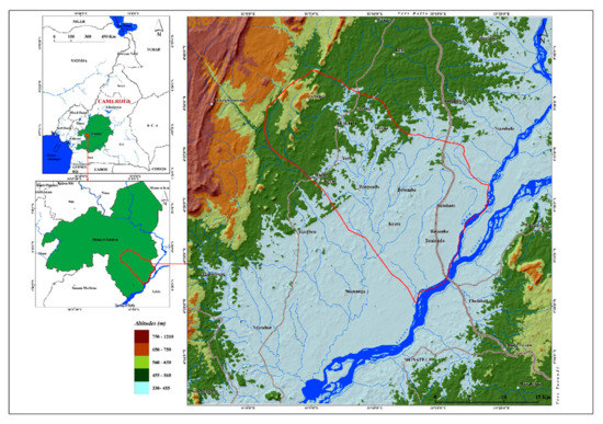
Figure 1.
Location of the study area.
To map agronomic suitability, soil samples were collected from a pit ranging from 1.50 to 2.0 m deep, and laboratory analysis was carried out. The particle size and pH were determined in the soil laboratory of the Department of Soil Sciences of the University of Yaoundé 1. Organic carbon (OC) and total nitrogen content were carried out in the soil laboratory of the International Institute of Tropical Agriculture (IITA) in Yaoundé. The agronomic suitability map of the soils was produced using the following formula: AA = pH × RU × K × CEC where, AA: agronomic suitability; pH: hydrogen potential; RU: useful water reserve; K: erodibility factor; CEC: cation exchange capacity. Soil pH was spatialized using kriging. Useful soil water reserve (RU) was computed using the equation in Remy [4]: RU = H × TE × (1 − (EG/100)), where RU: useful reserve water express in millimeters; H: thickness expressed in centimeters; TE: textural index determined from the texture class; EG: coarse elements expressed as a percentage. The soil thickness (H) was measured along the profile using a tape. The texture classes were determined with the USDA texture diagram. The texture index (TE) was classified using the methodology proposed by Jamagne [5]. The quantity of coarse elements was determined using the methodology proposed by Bouma and Van Lanen [6].
Soil erodibility factor (K) was calculated according to the formula provided by Wischmeier and Smith [7]: 1000 K = 2.8 × 10⁻⁴ (12-%MO) × M1.4 + 3.25 (S-2) + 2.5 (P-3) where, MO: organic matter in percentage; M = (% sands + % silt) × (100 − % clay); S: code on the soil structure; P: infiltration capacity. Soil structure (S) was determined using the texture diagram [6]. The obtained texture classes were then transferred to the correspondence table of [7] to obtain the numerical value of the structure code S (Table 1).

Table 1.
Meaning of codes on soil structure.
Soil permeability (P) was determined using the USDA diagram (Figure 2) and the correspondence was established in the table below [8] (Table 2).
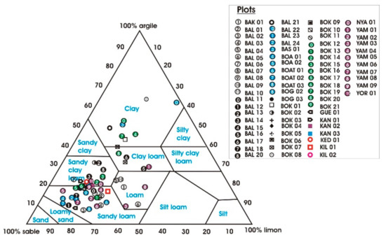
Figure 2.
USDA textural diagram.
Table 2.
Meaning of permeability (P) codes.
The CEC factor was calculated in the laboratory.
3. Results
Results showed that the Bokito soils range from sandy loam to sandy clay loam (Figure 2), which is dominated by coarse material (Figure 3). The yellow ferrallitic soils are moderately acidic (Figure 4A) with a good useful water reserve (Figure 4B). The CEC is maximum (Figure 4C) and the erodibility rate is high (Figure 4D). These soils have a very good agronomic suitability (Figure 4E).
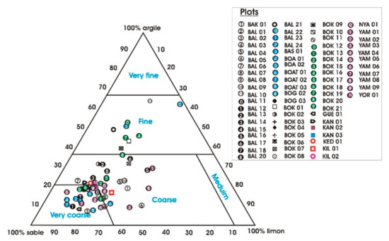
Figure 3.
Textural diagram of Jamagne.
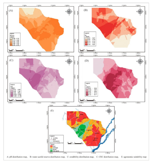
Figure 4.
Agricultural suitability map.
4. Discussion
The yellow ferrallitic soils of Bokito have a very good agronomic aptitude. Their pH varies between 6 and 6.22. These thresholds are favorable for fertilizing elements and soil microorganisms’ activity [9,10]. At a depth of 30 cm, the useful water reserve is at its maximum (0.229 mm) due to their high silt content [11,12]. The CEC reaches 6.65 meq/100 g soil. The very high erodibility in these soils is characteristic of humid tropical environments [13]. A field trip allowed for us to verify the obtained results. Indeed, agricultural yields are high in the yellow ferrallitic soils of Boganda village. This could support the choice of input parameters for the model.
5. Conclusions
Cameroon has agronomically suitable land that needs to be located and characterized. Their development could contribute to food security and environmental preservation. The proposed methodological approach allows for large-area mapping over a short period of time and could accelerate Cameroon’s transition to second-generation agriculture.
Author Contributions
Conceptualization, O.L., M.R.O. and P.N.; Methodology, O.L.; Software, O.L.; Validation, O.L, M.R.O. and P.N.; Formal analysis, O.L., M.R.O. and P.N.; Survey, O.L. and P.N.; Resources, Ministry of Agriculture and Rural Development. Data curation, O.L. and P.N.; writing—preparation of original draft, O.L., M.R.O. and P.N.; writing—revision and editing, O.L., M.R.O. and P.N.; visualization, O.L.; supervision, O.L.; project administration, O.L. and P.N.; procurement of funding, Ministry of Agriculture and Rural Development. All authors have read and agreed to the published version of the manuscript.
Funding
This research was funded by the Ministry of Agriculture and Rural Development of Cameroon/Direction of Agricultural Development.
Institutional Review Board Statement
Not applicable.
Informed Consent Statement
Not applicable.
Data Availability Statement
Soil Science Laboratory of the University of Yaoundé.
Conflicts of Interest
The authors declare no conflict of interest.
References
- Nguemezi, C.; Tematio, P.; Yemefack, M.; Tsozue, D.; Silatsa, T.B. Soil quality and soil fertility status in major soil groups at the Tombel area, South-West Cameroon. Heliyon 2020, 6, e3432. [Google Scholar] [CrossRef] [PubMed] [Green Version]
- Tematio, P.; Tsafack, E.; Kengni, L. Effects of tillage, fallow and burning on selected properties and fertility status of Andosols in the Mounts Bambouto, West Cameroon. Agric. Sci. 2011, 3, 334–340. [Google Scholar] [CrossRef] [Green Version]
- Lagacherie, P. Digital Soil Mapping: A State of the Art; Springer: Dordrecht, The Netherlands, 2008; Volume 2, pp. 3–14. [Google Scholar]
- Rémy, J.-C. Méthodologie pour l’évaluation des terres: Contraintes pédologiques et facteurs limitant l’utilisation des sols. In Sols et Environnement (Ouvrage); Girard, M.-C., Walter, C., Berthelin, J., Morel, J.-L., Eds.; Dunod: Paris, France, 2005. [Google Scholar]
- PJamagne, M.; Betremieux, R.; Bégon, J.C.; Mori, A. Quelques données sur la variabilité dans le milieu naturel de la réserve en eau des sols. Bull. Tech. Inf. 1977, 324, 627–641. [Google Scholar]
- Bouma, J.; van Lanen, H.A.J. Transfer functions and threshold values: From soil characteristics to land qualities. In Proceedings of the International Workshop on Quantified Land Evaluation Procedures, Washington, DC, USA, 27 April–2 May 1986; pp. 106–110. [Google Scholar]
- Wischmeier, W.H.; Smith, D. Predicting Rainfall Erosion Losses, a Guide to Conservation Planning. In Agriculture Handbook; US Department of Agriculture: Washington, DC, USA, 1978. [Google Scholar]
- King, D.; Le Bissonais, Y. Rôle des sols et des pratiques culturales dans l’infiltration et l’écoulement des eaux. Exemple du ruissellement et de l’érosion sur les plateaux limoneux du nord de l’Europe. C. R. Acad. Agric. France 1992, 78, 91–105. [Google Scholar]
- Bigorre, F.; Pedro, G. Contribution des argiles et des matières organiques à la rétention de l’eau dans les sols. Signification et rôle fondamental de la capacité d’échange en cations. C. R. Acad. Sci. Paris 2000, 330, 245–250. [Google Scholar]
- Ciesielski, H. Détermination of exchange capacity and exchangeable cations in soils by means of cobalt hexamine trichloride. Effects of expérimental conditions. Agronomy 1997, 17, 1–7. [Google Scholar] [CrossRef] [Green Version]
- Ridremont, F.; Lejeune, P.; Claesens, H. Méthode pragmatique d’évaluation de la réserve en eau des stations forestières et cartographie à l’échelle régionale (Wallonie, Belgique). Biotechnol. Agron. Société Environ. 2011, 15, 727–741. [Google Scholar]
- Duchaufour, P. Abrégé de Pédologie; Édition Masso: Paris, France, 1997. [Google Scholar]
- Roose, E.; Sarrailh, J.-M. Erodibilité de Quelques Sols Tropicaux. Vingt Années de Mesure en Parcelles D’Érosion Sous Pluies Naturelles; Centre ORSTOM: Montpellier, France, 1990. [Google Scholar]
Publisher’s Note: MDPI stays neutral with regard to jurisdictional claims in published maps and institutional affiliations. |
© 2022 by the authors. Licensee MDPI, Basel, Switzerland. This article is an open access article distributed under the terms and conditions of the Creative Commons Attribution (CC BY) license (https://creativecommons.org/licenses/by/4.0/).