Abstract
The city of Seville experienced a remarkable rise in the 16th century thanks to trade with America. Based on a report by the architect Hernán Ruiz, it was decided to renovate the gates of the walled city. The Puerta Real, also called Puerta de Goles, was remodelled between 1560 and 1566, and King Philip II entered through it in 1570. However, it was demolished around 1864, and only the remains of the adjacent wall stand today. This research aims to graphically analyse the gate and its immediate surroundings to gain a more profound knowledge of it and to promote its heritage value. To this end, an extensive collection and analysis of historical images has been carried out, which are essential for understanding the transformations of the site. A photograph by Masson (c. 1855–1860) was next used to support the virtual reconstruction of the gate. A 3D laser scanner was also used to document the existing archaeological remains and, via game-engine technology, to recreate rigorously, for the first time, this 16th-century gate in its current environment. This research could be useful for future scientific reconstruction to promote the heritage revitalisation of this city area.
1. Introduction
1.1. Baseline Considerations on the Graphic Analysis of Architectural Heritage
In recent decades, there has been a revaluation of architectural, urban and landscape heritage as a fundamental part of the cultural identity of cities and their citizens. Adequate graphic documentation is essential to know, make known and conserve this heritage, according to the recommendations by ICOMOS in 1966 [1]. In the case of undesired destruction of the architectural heritage, its intangible values can be safeguarded if there are graphic documents that allow its virtual recreation or actual reconstruction [2]. Despite the difficulty of defining universally valid theories or working methodologies for graphic research and heritage analysis, reviewing previous experiences can provide interesting working guidelines, which are always open and variable, to promote knowledge, conservation and enjoyment of heritage [3,4]. For this reason, some general references that have initially been of interest for this research are outlined below.
Firstly, it is worth highlighting the importance of the analysis of images from the past (maps, plans, views, photographs, among others) in what can be called “the graphic life of the architectural and landscape heritage” [5,6]. Although no image provides a totally objective view of reality, its graphic signs convey information about the external perception of its authors and their intentions, skills or sensitivity, depending on the graphic technique used. The localisation and analysis of historical images opens “windows to memory” that allow an insight into the transformations of heritage over time. This often requires multidisciplinary approaches to context, history, landscape, perception, construction, archaeology, and so forth. In some cases, it is possible to understand the differences between what has been planned and what has been built [7], and even utopian urban visions that were not executed [8]. At times, images have an artistic value independent of what is represented and constitute a graphic heritage in themselves, such as El Greco’s pictorial vision of the city of Toledo [9].
On the other hand, in recent decades, numerous and changing digital graphic tools have opened up new lines of research on architectural heritage in which experimentation plays a central role. Examples include the design and interconnection of heritage databases, given the transversality of these tools; or the potential of geographic information systems (GIS) associated with territory or mobility. Furthermore, Building Information Modelling (BIM) methodologies applied to architectural heritage (HBIM) introduce conceptual novelties in surveying, data analysis and collaborative work. All this brings new logics associated with the graphic analysis of heritage [10].
A very extensive bibliography exists on the digital modelling of architectural heritage over the last decades. From it, works on methodologies [11,12] were consulted on specific case studies and 3D reconstruction of missing heritage [13,14,15], and a recent book that gathers cases studies and compares experiences about digital restoration and virtual reconstructions [16]. Also, it was particularly interesting to address video game graphics engine technology applied to heritage, as it facilitates visualisation with a certain degree of realism and interaction for all types of users. This technology has been used in the scientific literature to render urban and natural environments, including heritage buildings [17,18] and sites [19] and fictional proposals for the sake of sustainable development [20] and aimed at landscape research and design teaching [21,22,23]. Future research into artificial intelligence could generate new fields of work that have yet to be explored.
Meanwhile, this graphic research is interested in an idea of architectural heritage that includes the citizen in a central position, promoting their integration in cultural, social, or economic processes. In this sense, the concept of landscape always implies the existence of someone who looks at it, according to the European Landscape Convention signed in Florence in 2000 [24]. Landscape was then defined as any part of the territory, as perceived by people, whose character results from the action of natural and/or human factors and their interrelationships. Furthermore, UNESCO already considered the landscape value of urban settings in 1976, in its Recommendation concerning the Safeguarding and Contemporary Role of Historic Areas [25]. Subsequent UNESCO documents have echoed important urban planning concerns by considering the dynamic character of the historic city, valuing open spaces, their perceptions and visual relationships [26].
A few decades ago, Kevin Lynch or Gordon Cullen claimed the role of the observer in city scenarios. Lynch’s contributions, collected in his book about the image of the city [27], focused on how people perceive and move around the city, paying special attention to urban landmarks. Cullen coined the term “townscape” in a book [28] that teaches how to observe and analyse the qualities of the urban environment. Through direct and sequential observations, drawing is key to discovering the details in which the pleasure of walking through the city lies. A recent review of Cullen’s work [29] highlights the repercussions of his ideas on generations of architects and their social values, considering patterns of behaviour sometimes ignored by urban designers. The recent movement called “urban sketchers” has embraced certain of Cullen’s ideas, focusing on everyday life in the city and disseminating the drawings on social networks [30]. In contrast to the automaticity and immediacy of modern photographs taken by any tourist, these drawings are loaded with social intentions and concerns.
Finally, in terms of possible future research, several destroyed heritage buildings are of interest, such as the Campanile in Venice [31] or the German Pavilion in Barcelona by Mies van der Rohe [32], which were reconstructed in their original location. In the case of the Puerta de la Latina in Madrid, the reconstruction was carried out in a different location, next to the Higher Technical School of Architecture [33]. It is also worth mentioning other debatable reconstructions that have favoured the social and cultural revitalisation of the place, as has happened in the Silk Road in China [34]. Considering the above, this paper aims to motivate future debates on the possible scientific reconstruction of the disappeared architectural heritage and its environment in contemporary culture.
1.2. Brief Description of the Puerta Real and Its Urban Environment in Seville
The city of Seville had an important medieval city wall, most of which disappeared in the 19th century, as occurred with the famous Puerta Real (Royal Gate). It should be noted that the gates still retained the appearance they had since the 13th century, in the Almohad period, without substantial change [35,36]. It was then decided to remodel them, taking the Roman triumphal arches as a reference point following the new artistic ideas of the Renaissance that came to the city via important Italian Renaissance merchants [37]. The idea was to offer a new image in consonance with the remarkable growth of a city whose port had a monopoly on co-trade with America.
The architect Hernán Ruiz, Master Builder of the Seville City Council, planned the renovation of the gates and their immediate surroundings, as documented in 1560. From a functional point of view, the aim was to eliminate obstacles to traffic; and from a symbolic perspective, to hide the Islamic vestiges, using a new classical architectural language [38] that would have the treatises of Serlio [39] or Vignola [40] as a reference point. The new gates of the wall would complete the transformation of the urban image as new symbols at its main entrances [41] (pp. 704–705). Besides, many significant monuments were built in Seville during the 16th century, such as the Lonja or Archivo de Indias, the new Town Hall, the Hospital de las Cinco Llagas, the Audiencia, or the Casa de la Moneda [42].
From the 16th century onwards, the defensive value of the walls was lost, and they took on a symbolic function. In addition, in this place the walls were a fundamental element in protecting the city from the floods of the Guadalquivir River. They were also a customs control point for the Spanish Crown, and some of them were shown in Spinola’s map of the city in 1827 [43].
However, the loss of the defensive value of the walls and their consideration as useless and an obstacle to urban progress led to their neglect and demolition by the City Council in the 19th century, despite some protests [44]. Only a part of the adjacent wall remains today after the demolition of the Puerta Real around 1864. Its architectural remains were dispersed, and the location of most of them is unknown today [45].
The disappeared Puerta Real, also called Puerta de Goles, is mentioned in various documents between the 13th and 15th centuries after the Christian conquest of the city [46]. The first archaeological references can be found in the preserved section of the wall next to the disappeared gate. The remains of the rammed-earth wall date from the Almohad period and are consistent with the written documentary sources [36,47]. The original medieval gate was rebuilt or repaired on several occasions due to damage caused by the river’s flooding. It was remodelled between 1560 and 1566 following the guidelines of Hernán Ruiz [48]. The place name ‘Puerta Real’ appears in documentary sources from 10 May 1570 onwards, when King Philip II, considered the most powerful man in the world at the time, entered the city through this gate [49].
It was located near the river port, in a place with a relatively depressed topography that would have reduced its defensive military capacity. Seen from the outside, it was partially hidden by a mound next to the banks of the Guadalquivir, whose origin would have been related to the rubble or rubbish that used to accumulate at the gates of the historic city in medieval times.
Hernando Colón, son of the Genoese admiral Cristóbal Colón (Christopher Columbus), built his important palace on this mound, occupying a former Islamic orchard on the land he was granted in 1526 [50]. The façade of the building was enriched with Genoa marble. Its library was also located there. The palace had gardens that altered the site’s topography, gardens with an ombú tree (Phytolacca) that was brought from America. The building was later used as the convent of San Laureano, after which it became a school [51]. An urban expansion was planned on the lower garden in the 19th century. The building has recently been restored and adapted for residential use, and its church is currently being rehabilitated for new cultural uses.
The suburb of Los Humeros is located next to the building of San Laureano, on the outside of the wall, and has been closely linked to the Guadalquivir River since its origin. The word humero refers to where the fish was smoked and salted to preserve it. The place names of the streets in this urban sector (Bajeles, Barca, Dársena or Redes) also maintain a clear relationship with the river.
In the vicinity of San Laureano, there is the Chapel of Our Lady of the Rosary (Our Lady of the Rosary), built around 1750. Next to it and west of San Laureano is Liñán Street, which leads to the current Plaza de la Locomotora, formerly Madre de Dios, located at the highest point of the mound. This name (locomotora, locomotive in English) is due to the railway built nearby from the 19th century until the end of the 20th century, radically transforming the image of the place.
Towards the interior of the city, next to the Puerta Real, there is a small square where an important axis of the historic centre ends, Alfonso XII Street, the former Calle de las Armas, which continues outside the city walls on the Cuesta de San Laureano. Gravina and Goles streets also converge in this square. Next to the Puerta Real is the small Chapel of Our Lady of Sorrows, rebuilt in its current historicist appearance by the architect Aurelio Gómez-Millán in 1944 [52]. Adjacent to the chapel, small houses have been attached to the wall parallel to Goles Street since the beginning of the 19th century. The church of San Laureano stands on top of the wall.
Current aerial photographs (Figure 1) show the location of the disappeared Puerta Real near the Guadalquivir, next to the San Laureano building and the Plaza de la Puerta Real.

Figure 1.
The urban environment and location (red curve) of the disappeared Puerta Real. Google Earth Pro 2023 [accessed on 15 April 2023]: (a) 3D aerial view; (b) Top view.
The following photographs offer a brief visual tour of the present-day urban environment: the end of Alfonso XII Street and the Chapel of Our Lady of Sorrows (Figure 2a), the preserved city wall remains (Figure 2b), the San Laureano building and Liñán Street (Figure 3a), the meeting of Barca and Goles streets (Figure 3b), a view of Goles Street and the Church of San Laureano (Figure 4a), and a view of the Plaza de la Puerta Real (Figure 4b).
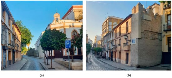
Figure 2.
The urban environment of the disappeared Puerta Real. Authors’ photographs, 2023: (a) View from Alfonso XII Street towards the Chapel of Our Lady of Sorrows; (b) View toward Alfonso XII Street and the adjacent remains of the city wall.
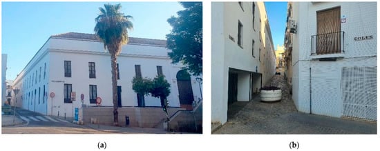
Figure 3.
The urban environment of the disappeared Puerta Real. Authors’ photographs, 2023: (a) View of the San Laureano building and Liñán Street; (b) View of Barca Street from Goles Street towards Plaza de la Locomotora.
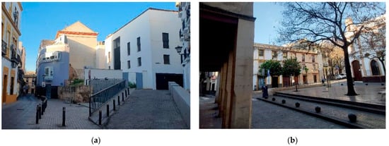
Figure 4.
The urban environment of the disappeared Puerta Real. Authors’ photographs, 2023: (a) View of San Laureano and the city wall remains in Goles Street; (b) Puerta Real Square.
1.3. Previous Studies on Seville’s City Walls and Gates
In order to adequately contextualise and assess the disappeared Puerta Real in Seville, an extensive local bibliography search was carried out, summarised below.
On the Islamic wall, the book by Valor-Piechotta [35] provides a comprehensive overview, and a book chapter by Ramírez-Reina [36] summarises historical and archaeological issues. Three books with historical data are fundamental to understanding the important transformations in the city gates. The first one, by Albardonedo-Freire, covers the urban planning in Seville in the 16th century, during the reign of Philip II [48], encompassing an earlier article on the Puerta Real [50]. The second book, by Raya-Rasero [45], addresses the critical demolitions of heritage buildings in the city during the second half of the 19th century. The third publication, by Maqueda-Jiménez [46], compiles historical data on each gate with an approach close to archaeology. Two other books combine images and historical data with a journalistic approach to highlight the value of this missing heritage [53,54].
Regarding the history of Seville’s streets and squares, the books by Collantes-de-Terán-Sánchez and Cortes-José [55] and Passolas-Jáuregui [56] (pp. 386–387) were consulted. As for the area near the Puerta Real, the doctoral thesis by Pozo-Barajas [52] analyses the transformations of the Humeros Suburb. A key architectural element in this area is the current San Laureano building, which has undergone many transformations throughout its history [57].
With respect to urban cartography, a publication has been consulted that reproduces the main historical maps of the city from the end of the 18th century [58], and a recent book includes other important historical maps and plans from the 16th to the 20th centuries [59].
In terms of historical images of the city, it is crucial to review the various volumes entitled “Iconography of Seville” [60,61,62]. Special attention should be paid to an English traveller, Richard Ford [63,64,65,66], who made nearly a hundred drawings between 1830 and 1833 when photography did not yet exist, many of them of the city wall and its gates. Shortly after its demolition, Bartolomé Tovar published a series of lithographs of the gates in 1878 [67], although many of them appear overly idealised.
The archaeological sources consulted are the records of the excavation carried out at the Puerta Real by the Municipal Urban Planning Department of Seville archaeologists in 1995, which was partly published [47].
As for the graphic analysis of the disappeared gates, it is worth referring to an article by Gámiz-Gordo and Barrero-Ortega on the Puerta de Triana [68] and their book chapter on the Puerta Real [69], which includes historical images, without going into the study of the urban environment, which is the subject of this research.
1.4. General Objectives
The main objective of this research is to document and graphically analyse the disappeared Puerta Real and its immediate surroundings through historical images of Seville, gathered and arranged chronologically, taking into account the urban transformations. This research also aims to document the existing city wall remains and to offer a rigorous digital recreation of the gate and its surroundings based on 3D laser scan data and other digital resources. In this way, the value of a city area loaded with history can be enhanced, as a starting point for a future debate on the possible reconstruction of the disappeared gate, as a symbol of urban identity and a source of progress in order to favour the future revitalisation of this area of the city’s heritage.
The rest of this paper is organised as follows: Section 2 describes the methodological approach and processes adopted, dealing with historical images and current digital technologies; Section 3 gathers and discusses the results of the historical image analysis and digital documentation of the Puerta Real and its surroundings; finally, after a brief summary of the research context and objectives, Section 4 draws the main conclusions, including the contribution of this paper and future works.
2. Methodology
The methodology of this graphic research is characterised by the combination of the analysis of historical images with the use of current digital technologies. Previous work involving this combination was reviewed, mostly related to architectural objects [70,71,72], and some others to urban environments [68,73].
Moreover, in order to understand the transformations of the site, it was essential to analyse the historical images in chronological order, considering both the graphic techniques and the interests of each period’s authors. The analysis of historical images was not used to digitally model the urban environment in different time spans, but to detect points of view of heritage interest, considering the aforementioned UNESCO recommendations on urban landscape perception and the theories by Lynch and Cullen.
Furthermore, it should be noted that the use of various digital technologies enabled the highlighting of a clear difference between the current state of surroundings (represented using the point cloud), the preserved remains of the wall (graphic documentation through 3D meshes) and the gate that disappeared and was recreated graphically (CAD modelling). Given that greater definition was sought for the disappeared gate and the archaeological remains, no homogenous treatment of all those elements in a single 3D model seemed to be appropriate. For this reason, a hybrid digital model developed on a platform based on videogame graphic engine technology was chosen for its ease of use, versatility, speed, and the graphic quality obtained. This procedure has been used for the first time in the reconstruction of the disappeared 16th-century gates in the city of Seville. Its use will allow the creation of immersive experiences to explore this urban environment for future dissemination purposes, taking as a reference a previous case study on the oldest inn in England (1189 AD) [74].
2.1. Localisation and Analysis of Historical Urban Environment Images
The city of Seville has an extensive legacy of historical images by a wide range of authors who, from the 16th century onwards, provided valuable data on its urban transformations. Together with other historical or archaeological sources, they are of great interest for heritage research, considering the current reality.
A thorough search was conducted to locate significant images of the area around the Puerta Real. However, some of them have been reproduced in previous studies, and until now, they have not been analysed as a whole. Data have also been gathered on the context of each image, considering its techniques, scales and the training, skills or interests of its authors. It should not be forgotten that any image always responds to certain personal intentions with varying degrees of approximation to the reality represented.
Finally, the images were ordered chronologically. Each type of image offers a specific type of documentary information. For example, scale plans offer measurements or proportions, while views or perspectives are more easily understood by the observer, as in the case of photographs. In addition, particular historical images can evoke visual pleasure and possess artistic value. In any case, the graphic ensemble analysed is an essential source of knowledge for understanding the transformations of this heritage environment.
2.2. Virtual Recreation: Urban Environment, City Wall Remains, and the Disappeared Gate
2.2.1. Data Collection of the Urban Environment: 3D Scanning Survey
Terrestrial Laser Scanning (TLS), a well-known technology in the Cultural Heritage field, was used in this research to digitise Puerta Real’s urban environment. The 3D survey required operating the laser scanner from different positions (here called scan stations) to capture most of the geometry of the public spaces and buildings surrounding the former gate area. The reason for this was the existence of narrow alleys, an arcade to be recorded in Plaza Puerta Real, and occlusions caused by trees and canopies on the streets. These obstacles would imply insufficient overlap between stations if fewer positions were established.
Following an ordered sequence, the 3D scanning covered the surroundings of the former gate, mainly including the Plaza Puerta Real, the San Laureano building, and adjacent streets. The 3D survey was conducted using the following equipment: a Leica Geosystems BLK360 G1 laser scanner [75] (Figure 5a), a device validated in previous published international research [76,77,78]. A 9th-generation Apple iPad Pro [79] was used to operate the TLS device via Wi-Fi and visualise the collected point cloud data in situ. The Leica Cyclone FIELD 360 app [80] was used in the tablet to set the scanning at medium resolution (standard point density mode, at 10 mm resolution at 10 m), except for stations 51, 52, and 53, which were set at high-density mode (5 mm resolution at 10 m) to cover greater distances to minimise point density loss. High Dynamic Range (HDR) colour imaging (2592 × 1944 pixels) was activated. No targets were used in the scanning. According to the manufacturer’s specifications, the scanning range accuracy is from 4 mm at 10 m to 7 mm at 20 m, and the 3D point accuracy is from 6 mm at 10 m to 8 mm at 20 m. The tilt error of the 3D laser scanner is 0.0385°, as seen in previous research [76].
Next, Leica Cyclone REGISTER 360 software [81] enabled importing the scan data and computing automatic registration (scan alignment) to produce a global raw 3D point cloud with more than 533 million points. The registration results of the 3D survey (Figure 5b) include 49 stations and 118 scan links between them. The scanning report yielded an absolute mean error of 6 mm, 48% overlap, and 73% strength.
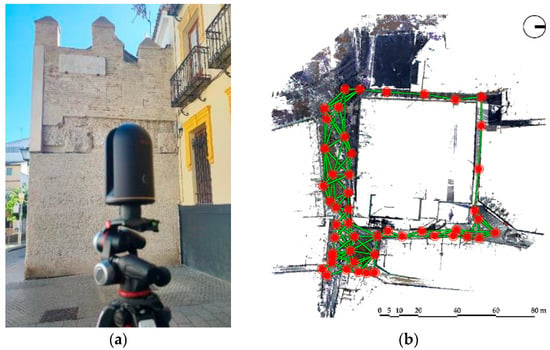

Figure 5.
3D laser scanning survey: (a) TLS device. Authors’ photograph, 2023; (b) Registered point cloud data with stations and links. Authors’ work, 2023.
2.2.2. Data Processing and 3D Meshing of the Preserved City Wall Remains
In order to use the TLS data to generate 3D models, removing unwanted elements and noise is desirable; i.e., the 3D point cloud requires a segmentation process. CloudCompare software [82] was used to create trimming polylines and clean the data. Also, processing fewer points eases data handling, which means smaller file sizes. This was achieved by subsampling the global point cloud except for the remains of the former city wall, which maintained the original point resolution (3 mm) so that their geometry could be analysed in the future. The point reduction was determined by distance, set to a minimum of 30 mm between points, reaching over 97% decimation. Once the point cloud data were processed, the 3D reconstruction took place.
In the urban environment of Puerta Real, the existing remains of the former city wall are two: (a) a five-metre section in length adjacent to the disappeared gate (Puerta Real) and (b) a second section on Goles Street, 16.70 m long. As seen above, the segmented point cloud was used to 3D-reconstruct these elements from the original resolution. The 3D meshing procedure was carried out with the smoothening degree determined by the Octree depth level 9 (level 10 for (b)), as in [76], by implementing the ‘Screened Poisson Surface Reconstruction’ algorithm [83] in CloudCompare. This smoothening degree was selected given the accuracy analysis carried out by those authors and the unsuitable experimental results with higher levels in this research, which produced noise on wall surfaces. Due to its height, when occlusions occurred on hidden parts and at the top of the adjacent wall section (a) during the TLS survey, the hidden sides of the walls (back and bottom) and the back of the battlements, respectively, were 3D-reconstructed by inserting point grids on plane surfaces created to define their geometry. Similarly, in order to determine a closed volume for the two sections of the wall, measurements were taken of their thickness. Thus, the algorithm computed watertight 3D meshes of the wall sections to be next inserted into the 3D urban environment of Puerta Real.
Further, given the multiple materials existing in the adjacent wall remains, further segmentation of the 3D meshes was needed so that different elements were separated into individual objects to be mapped with textures to ensure a more realistic representation. The segmentation was performed by trimming the 3D meshes in CloudCompare, as in the case of the point cloud.
2.2.3. Virtual Modelling of the Puerta Real
In previous research [69], the process for the virtual, geometric and dimensional reconstruction of the disappeared Puerta Real is described without considering textures or lighting. For this purpose, the only surviving photograph Masson took around 1855–1860 and then commented on was used. It was processed with Asrix software to rectify the image as per the elevation. To deduce dimensions from the photograph, measurements were obtained from the preserved archaeological remains: the adjacent wall; the pavement that has marked the position of the gate since its archaeological excavation in 1995; and a 160 × 70 cm memorial stone plaque that was part of the gate (Figure 6a), today placed on the adjacent section of the wall. The measurements from the late 19th-century plans, discussed below, have also been examined. In addition, it was assumed that classical architecture is always based on interrelated proportions. Following Hernán Ruiz II’s Book of Architecture [84] and Sebastiano Serlio’s treatise [39], geometric tracings were used to support the general architectural design and its details (Figure 6b).
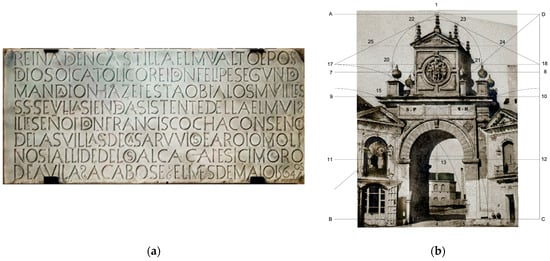
Figure 6.
(a) Commemorative stone initially located on the interior façade of the Puerta Real, today placed on the adjacent section of the city wall. Authors’ orthophoto, 2023; (b) Restored photograph by Masson (c. 1855–60) and hypothesis of auxiliary tracing. Authors’ work, 2023.
The topological analysis from the rectification of Masson’s photograph enabled 2D drawings and a strictly geometrical 3D model of the gate. However, in this research, a second iteration of the model detected the possibility of including adjustments in their proposal. Examples of these are: the lack of symmetry of mouldings in the upper body of the building, since they should follow the circular pattern and be mirrored around the quadrants, with a coherent thickness among them; the representation of inexistent joints in the intrados of the central arch; and non-clear correspondence of 2D drawings (top view, elevation, and sections), as they presented different wall thicknesses. As a result, it was necessary to revise the previously published 3D modelling of Puerta Real. To do this, the topological outline was first verified against the original photograph by Masson to start extruding the contours and defining the shapes by creating closed polysurfaces in Rhinoceros software [85]. Through Boolean operations (difference and split), the depth of the elements was determined as per the verified gate 2D section.
2.2.4. Recreation of Puerta Real and Its Environment: Game-Engine Technology
Following the primary geometric virtual reconstruction, now revised, video game technology was implemented to recreate the Puerta Real and its environment.
In recent years, game-engine technology has significantly improved the rendering quality towards photorealism and aims at interoperability and automation [86]. Beyond the gaming industry, this technology allows for a more realistic visualisation of heritage assets, which impacts representation accuracy against basic textures with no normal mapping and primitive environmental conditions. Global lighting (environmental settings such as Sun, Moon, exposure and ambient), global illumination through dynamic indirect lighting—this simulates how light interacts with surfaces and materials—and high-definition shadows, HDRI (High Dynamic Range Image) environments and weather conditions, as well as the so-called bump maps (normal and height maps) for texture enhancement, make the difference today.
In this research, the Unreal Engine-based Twinmotion software developed by Epic Games [87] was used to import the segmented global point cloud into the 3D space. However, to ensure a more realistic representation for the existing wall remains, it was decided to insert their segmented 3D meshes instead of the point cloud data of those sectors. The new Puerta Real model and its passageways, later explained, were also imported.
Next, stock textures were selected to map the 3D objects according to the distribution of different materials in the wall remains and the Puerta Real. The mapping was conducted using the UV (texture coordinates) in the original 3D objects. Besides, the materials’ colour, gamma/brightness, scale, and roughness were reproduced to mimic the original appearance.
Finally, the above global lighting and illumination settings were determined to ensure a more realistic context. In this sense, the coordinate system was also geo-referenced so that the Sun’s path represented the actual solar radiation incidence (azimuth and elevation angle).
3. Results and Discussion
3.1. Historical Graphic Documentation
3.1.1. Images from the Late 16th to the Mid-19th Century
From the second half of the 16th century onwards, the city of Seville was depicted in various images that mainly focused on its river port as a symbol of prosperity. One of the first drawings was made by Anton van den Wyngaerde around 1563–1567 [60] (p. 76). The author labelled the name “Puerta de Goles” next to the palace of Hernando Colón, although its volume was vaguely sketched. This label also appeared in a view by Joris Hoefnagel published in volume I of Civitates Orbis Terrarum [88] alongside the label “La Casa de Colón” (Columbus’ House). The Puerta Real is not shown because it was hidden behind the abovementioned mound or was under construction when the artist visited Seville around 1563–1567 [89]. In addition, small fishing boats are depicted in the foreground, a common activity on this stretch of the river, which was not accessible to large ships because the Barcas Bridge prevented them from reaching that area.
An important image, drawn and engraved by Antonio Bambrilla, depicting the walled city of Seville from a raised viewpoint, was published in 1585. With some modifications, this view was also published in volume IV of Civitates Orbis Terrarum [90]. The main gates were drawn and identified in the legend (Figure 7a). Among them, for the first time, the Royal Gate, already remodelled by Hernán Ruiz, was depicted with its peculiar top but with an exaggerated size in relation to the adjacent buildings, possibly to emphasise its urban importance. Hernando Colón’s house was also identified—and the huerta (orchard) of its palace labelled Güerta—although he died in 1539 (Figure 7b). This view was the subject of many plagiarisms that spread the image of Seville and the Puerta Real throughout Europe [89]. For example, it was reinterpreted in a schematic and idealised form in a 1626 reprint of Sebastian Munster’s Cosmographia Universalis [60] (p. 153). In it, the Puerta Real is also represented as a tower of exaggerated size, emphasising its symbolic importance.
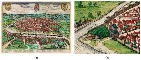
Figure 7.
View of Seville engraved in the 16th century. Civitates Orbis Terrarum, vol. IV, 1588. Private collection: (a) General view of the city; (b) Detail of the urban environment of Puerta Real.
Another important panorama of Seville, as seen from Triana, was published by the cartographer, engraver, and merchant Johannes Janssonius in Amsterdam in 1617. In the foreground, he incorporated details of the port and numerous ships, illustrating the prosperity of the time. However, the towers and gates of the city wall were drawn in a fanciful manner. Hernando Colón’s palace is shown next to his orchards and a kind of mound, but the Puerta Real was also unclearly depicted as turned to the south as part of the city’s façade towards the harbour (Figure 8a). This view would inspire another image by the Swiss engraver and publisher Mathäus Merian, published in 1638, which was widely circulated and suffered a variety of plagiarisms far removed from urban reality [60] (pp. 133–140).
Also worth mentioning is an anonymous oil painting dated around 1660, stored in the Focus-Abengoa Foundation in Seville [91], linked to a collection of views of cities commissioned by King Philip IV. This view of the city also features the river Guadalquivir and its port. Although the Puerta Real was not depicted, the topography around it is notable for the location of Hernando Colón’s palace, with two towers at its corners, which would correspond to the Colegio (School) de San Laureano, inaugurated in 1601 [51,57]. In another panoramic view of Seville and the river, an anonymous oil painting dated 1727 and preserved in the Seville City Hall building [92], the Puerta Real is depicted in the legend as number 7. Next to it also appears the mound, with an accentuated size, and the Colegio de San Laureano, with towers at its corners (Figure 8b), as in the oil painting mentioned above.
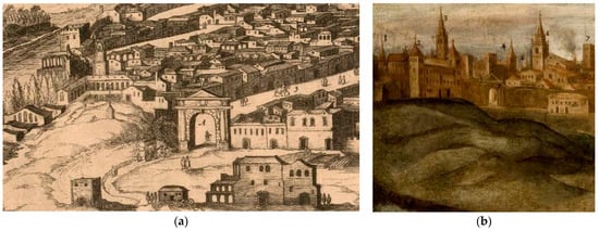

Figure 8.
Historical images of Seville: (a) Detail of engraved view by Janssonius (ed.), 1617. National Library of Sweden [available online https://lccn.loc.gov/2021670740 (accessed on 15 April 2023)]; (b) Detail of anonymous Seville oil on canvas, 1727. Ayuntamiento de Sevilla [available online: https://commons.wikimedia.org/wiki/File:Vista_de_Sevilla_%28siglo_XVIII%29.jpg (accessed on 15 April 2023)].
The Puerta Real also appears remarkably schematically in a sketch dated c. 1764 preserved in the Municipal Archives of Seville (Figure 9a). It shows the route of the pipes, tanks and fountains that distributed the water from the Fuente del Arzobispo spring, which supplied a section of the historic quarter [93,94]. Next to the “Puerta Real” sign, drawn as a discontinuity in the wall, “Fuente Pública” (Public Fountain) was drawn and labelled as a prism with a water outlet that falls into a lower basin (Figure 9b). The Municipal Archives of Seville contain 16th-century documentation on the cleaning and repair of the Fuente del Arzobispo [48] (pp. 203–242) and on fountains in public places in the city [95]. In the 16th century, Seville’s public fountains were treated with artistic intentions. Some, such as the one located in the Plaza de Pilatos, were drawn by Richard Ford around 1830–33 [63,64] with elements similar to those used by Hernán Ruiz [84]. Therefore, it is conceivable that this architect was the author of the fountain design in the square next to the Puerta Real.
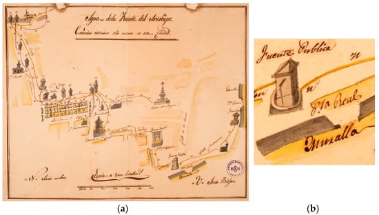
Figure 9.
Anonymous view of Seville c. 1764, ‘Agua de la Fuente del Arzobispo. Cañerías interiores de la misma en esta Ciudad’. Archivo Municipal de Sevilla, Pl. I-3-63, Digit. 4727: (a) General view of water distribution in the city; (b) Detail of water fountain in Puerta Real.
The first topographical map of Seville was published in 1771, and is known as the ‘Olavide map’ because it was drawn up by order of Pablo de Olavide, although the map was drawn up by Francisco Manuel Coelho and engraved by José Braulio Amat [59]. Although it has deformations in some city sectors, he defined the blocks, squares, and streets in detail, highlighting the main buildings and indicating the orchard areas with exhaustive toponymy.
In the vicinity of the Puerta Real (Figure 10), the retaining wall that formed a ramp next to the city wall, shown in other city maps and demolished around 1856, is depicted. A staircase is also shown next to San Laureano. The considerable length of the ramp and the number of steps of the stairs indicate the considerable difference in level between the level of the Puerta Real and its exterior, which still exists today. These accesses may have been formalised under the programme of repairs and reforms of the assistant Marquis of Monterreal in 1758, centred on the city gates. The building of San Laureano and its church were also depicted, with a street or passage between the two, the existence of which has not been ascertained.
Near the Guadalquivir, some building blocks appear, and to the north, the Chapel of Our Lady of the Rosary is detailed and the streets of the suburb of Los Humeros: Dársena and Bajeles, known as Calle de Abajo and Calle del Medio in this map, appeared without a connection to Goles Street. The so-called “Huerta de Colón” was also detailed. The wall formed the western façade of Goles Street. However, the houses attached to it today near the Puerta Real, probably built at the beginning of the 19th century, are not shown.
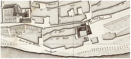

Figure 10.
Detail of Puerta Real in the city map by Olavide, 1771. Real Academia de la Historia, Madrid, C-011-002-17 [available online: https://www.sevilla.org/cartografia-historica (accessed on 15 April 2023)].
Based on Olavide’s map, Yldefonso Sierra drew another remarkable and lesser-known map in 1837 for military purposes [59]. It was intended to synthesise the state of the town’s defences after the urgent works carried out in response to the threatening military incursions of the First Carlist War. This is one of the last military maps of Seville’s city walls before most were demolished in the second half of the 19th century. The perimeter of the city centre was outlined, the interior of which was left blank, plus the strip of its immediate periphery. Notes were included on the deteriorated defensive capacity of the walls, the new constructions to reinforce them and the location of the main points of interest, indicating the opening of some trenches. The extensive development of tree-lined promenades between the walled enclosure and the Guadalquivir was also depicted. The Puerta Real was referenced in the legend as number 2, and the suburb of Los Humeros was depicted without detailing its interior streets (Figure 11).
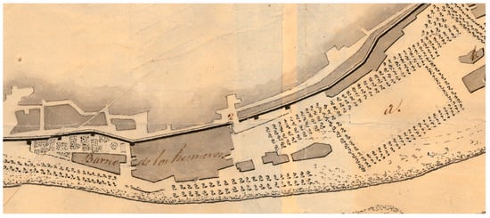
Figure 11.
Detail of the city map by Yldefonso Sierra, 1837. Cartoteca del Archivo General Militar de Madrid, PL SE-9/20 [available online: https://www.sevilla.org/cartografia-historica (accessed on 15 April 2023)].
As seen above, Richard Ford completed a significant number of views of the city and others throughout Spain, all of them of great documentary value. It is one of the most extensive repertoires of 19th-century views of urban landscapes. Ford said that the first thing to do in Seville, after climbing the Giralda to contemplate the city, was to take a horseback ride around its walls [96]. Many of his drawings focused on them and their gates. Two accurately detailed the Puerta Real and its urban environment [65] (pp. 34, 133).
One of the drawings was made outside the city (Figure 12). As previously mentioned in Olavide’s map, the lower part of the gate was hidden by the retaining wall due to its depressed topographical position. The façade of the Colegio de San Laureano appears on the left, whose decadence was accentuated after the despoilment during the Napoleonic invasion, a fire in 1817 and some subsequent marginal occupations [52]. The church of Nuestra Señora de la Merced, today part of the Museo de Bellas Artes, stands out behind the wall, and the Giralda can be seen in the background.
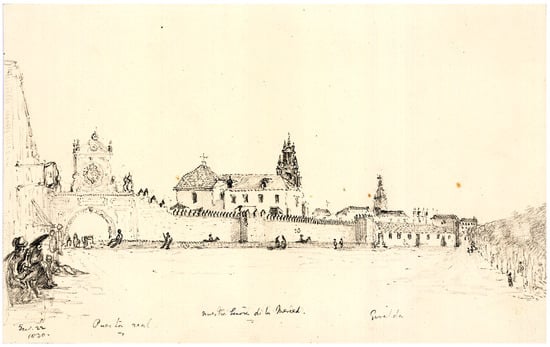
Figure 12.
Richard Ford’s drawing seen from outside the walled city (1830). Ford Family Collection, London.
The other drawing by Ford placed the viewpoint next to the arcades or porticoes that currently remain in the Plaza de la Puerta Real (Figure 13). The interior elevation of the gate, with two side oratories that existed in 1801, was depicted with a certain degree of accuracy. In the one on the left, a lower chapel was dedicated to the Christ of Redemption, the Virgin of Sorrows, and Saint John the Evangelist. The upper chapel had a painting of the Virgin of Mercy, and the chapel on the other side was reserved for Saint Anthony of Padua [52]. Next to the chapel are houses attached to the wall that did not appear in Olavide’s map of 1771, and the Church of San Laureano emerges above them. Also, the abovementioned fountain and basins or washing places can be seen in the foreground, together with women carrying pitchers on their heads. Although the drawing may seem plausible, the two figures on the left in the foreground are tiny in relation to the height of the arcades depicted.
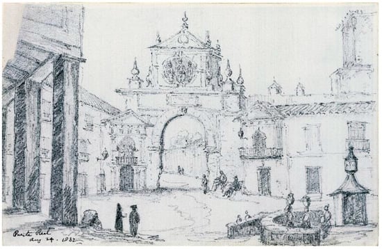
Figure 13.
Richard Ford’s drawing seen from inside the walled city (1832). Ford Family Collection, London.
Another beautiful and little-known drawing of the Puerta Real by the Swedish painter Egron Lundgren [97] is in the National Museum in Stockholm. After receiving a scholarship from the Stockholm Academy of Fine Arts to undergo training in Paris and Rome, the artist came to Spain and remained in Seville from August 1849 to June 1853. He later worked in England as a painter for Queen Victoria, returning to Seville in 1857 and after 1860. He produced various drawings of the city’s architectural heritage and characters. One has a viewpoint on the Plaza de la Puerta Real, very similar to Ford’s, with precise details, accentuating light and shade on grey paper (Figure 14a).
It is also worth mentioning a drawing by Basilio Tovar published in 1878, fourteen years after the demolition of the Puerta Real [67] (Figure 14b). The lack of a direct reference point would be the reason for certain disproportions in the upper body, depicted with an exaggerated width; its dimensions seem generally unreliable. In the background, through the doorway, the existing portico in the square is represented schematically.
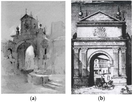

Figure 14.
(a) Drawing of Puerta Real by Egron Lundgren, c. 1849–1860. National Museum, Stockholm, NMH A 501/1981; (b) View of Puerta Real published by Tovar in 1878.
Of particular interest is the only known photograph by Louis Masson of the Puerta Real before its demolition around 1864 (Figure 15a). It was included in an album dedicated to the Dukes of Montpensier [98] (p. 241). It provides valuable architectural details of the door and its side chapels, consistent with Ford and Lundgren’s drawings, allowing the virtual recreation to be undertaken where possible. Through the gate, buildings can be seen outside the walls close to the river, in a place radically transformed around 1863 by the arrival of the railway [98].
Finally, the architect Rafael Manzano-Martos, professor and winner of the 2010 Driehaus Prize [99], made a freehand drawing around 2006 based on Masson’s photograph (Figure 15b). It is part of an academic proposal to reconstruct some of Seville’s city gates demolished in the 19th century. The aim was to recover the historical memory and promote the heritage revitalisation of essential entrances to the historic centre. In the case of the Puerta Real, two lateral arches were designed to facilitate pedestrian circulation, and it was also proposed to remodel the current façade of the Chapel of Our Lady of Sorrows.
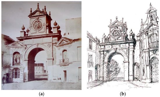

Figure 15.
Puerta Real seen from the interior. (a) Photograph by Louis Masson, included in an album dedicated to the Duke and Duchess of Montpensier, c. 1855–60. Duke of Segorbe’s private collection, Seville; (b) Reconstruction drawing by Rafael Manzano, 2006. R. Manzano private collection, Seville.
3.1.2. Maps between the Late 19th and Early 20th Centuries
Notable is the representation of the city of Seville and its periphery made around 1870, at an approximate scale of 1:5000, by Major Pedro García Falces and Lieutenant Luis Moncada [59] (Figure 16). This thorough survey, based on systematic data collection by other military personnel, surpassed in accuracy all previous mapping of Seville. It involved using the decimal metric system and triangulation techniques, including equidistant contour lines every 3 m.
In the environment of the Puerta Real (Figure 16), the main urban elements were defined reasonably accurately and with careful toponymy. The contour lines identify the mound crowned by the San Laureano building and the depressed site of the Puerta Real. What were once the gardens and orchards of the palace of Hernando Colón in the Humeros suburb are still unbuilt. The tremendous impact of the arrival of the Seville–Cordoba railway and the construction of the nearby Plaza de Armas Station, now converted into a shopping centre, can be seen. These railway lines ran alongside the Guadalquivir and prevented the city from being in contact with the river until they were dismantled for the Universal Exhibition in Seville in 1992.
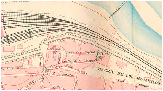

Figure 16.
Detail of the city map by Pedro García and Luis Moncada, 1870. Cartoteca del Centro Geográfico del Ejército, Ar.G-T.7-C.2-430 [available online: https://www.sevilla.org/cartografia-historica (accessed on 15 April 2023)].
It should not be forgotten that the urban landscape of 19th-century Seville was that of a walled city with narrow streets, few squares, and a rural-looking hamlet. The whitewashed façades were dominated by asymmetrical openings, contrasting with singular buildings such as churches, palaces, and others. The streets were not paved, and there were no water or sewage systems. Social life used to take place inside the houses and yards. The primitive urban planning aimed to transform this image, with wider and straighter streets, new public spaces, carefully designed façades and tree-lined streets, among other facilities [100].
The planned transformations around the Puerta Real at the end of the 19th century are reflected in the so-called maps of façade alignments in the historic centre, which are kept in Seville City Hall. They were drawn at a scale of 1:300 and included dimensions and elevations. In them (Figure 17 and Figure 18), the changes in alignment proposed for Calle de las Armas (now known as Alfonso XII Street) in 1874, for Puerta Real Square in 1880, and San Laureano Street in 1888 are shown in red ink. Many of these transformations were never carried out. The position of the Puerta Real, which no longer exists, is still shown on the map but practically erased, including the levels of the surrounding area.
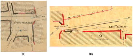
Figure 17.
Details of façade alignment maps near the Puerta Real, 1874–1898. Urban Planning Management, Seville City Council, 113/2019 and 207/2019 [available online: https://www.urbanismosevilla.org/areas/planeamiento-desarrollo-urbanistico/planeamiento-historico (accessed on 15 April 2023)]: (a) Detail of Puerta Real Square; (b) Detail of San Laureano Street, today Alfonso XII Street.
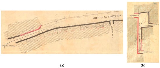
Figure 18.
Details of façade alignment maps near the Puerta Real, 1874–1898. Urban Planning Management, Seville City Council, 237/2019 and 207/2019 [available online: https://www.urbanismosevilla.org/areas/planeamiento-desarrollo-urbanistico/planeamiento-historico (accessed on 15 April 2023)]: (a) Detail of Goles Street; (b) Detail of Barca Street.
Also noteworthy are other maps dating from around the end of the 19th century that are kept at the National Geographic Institute in Madrid. For Seville, there are a total of 75 sheets with partial surveys carried out between 1894–1898 and 1907–1908 [59]. The area around the disappeared Puerta Real appears on two sheets on which the blocks of the Humeros suburb were accurately drawn at a 1:2000 scale (Figure 19a). The urban reality reflected in this map contrasts with other new alignment maps from the beginning of the 20th century. The latter attempted to continue the interior renovation operations and modifications of alignments or with proposals to open new streets, which in many cases were never carried out (Figure 19b).
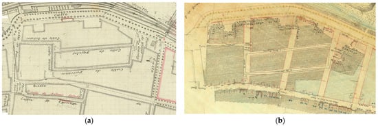
Figure 19.
Urban environment of disappeared Puerta Real: (a) Detail of map, 1897–1899, Instituto Geográfico Nacional, Madrid, Archivo Técnico 410789 and 410791; (b) Detail of map, 1881–1917. Urban Planning Management, Seville City Council, 172/2019 [available online: https://www.urbanismosevilla.org/areas/planeamiento-desarrollo-urbanistico/planeamiento-historico (accessed 15 April 2023)].
3.1.3. Aerial Photographs of the 20th Century
From the beginning of the 20th century, the possibility of flying and obtaining aerial photographs revolutionised the vision of the city, providing a valuable documentary basis for planning new urban analyses and for obtaining a precise cartography. Aerial photographs of the city taken between 1944 and 2008 are available on the website of the Seville Urban Planning Department and are fundamental for understanding its urban transformations [101].
As an example, here is an aerial view from 1944 and another in colour from 1985 (Figure 20). The former shows the building next to the chapel of Our Lady of the Rosary, and the latter shows a plot of land. In addition to the renovation of the hamlet, changes can be seen in the San Laureano building and the opening of a new connecting street between Plaza de la Locomotora and Goles Street (Figure 3b). The 1985 photograph shows a break in the alignment of the western façade of Goles Street, where it meets San Laureano, corresponding to a diagonal imposed by the Interior Renovation Plan for the Historic Centre in 1968 [52]. Fortunately, that plan was cancelled, and the extension of that diagonal, which would have entailed the destruction of San Laureano, was not carried out.
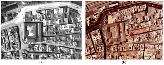
Figure 20.
Aerial photographs of the surroundings of Puerta Real. Seville City Council [available online: https://sig.urbanismosevilla.org/Sevilla.art/VisorKML/Sa_visorVUELOS_GU.aspx (accessed on 15 April 2023)]: (a) View of 1944; (b) View of 1985.
3.1.4. Archaeological Data from the Excavation in 1995
In 1995, the Urban Planning Department of the Seville City Council undertook an archaeological excavation at the junction of Alfonso XII Street and the Puerta Real Square to reveal the original layout of the site (Figure 21 and Figure 22). This file was consulted and discussed personally with one of the archaeologists who undertook the excavation, which was partially published [47]. Then, the adjacent wall and other remains from the medieval period were discovered and recovered. In the photos of the excavation and the plans of the dossier, the stone ashlars of the foundations of the 16th-century gate can be seen. Today, there is a different paving marking its location. In addition, the top part of the recovered wall was covered with the above-commented memorial stone plaque in the gate’s entablature (Figure 6a). It was deposited in 1880 in the collections of the Provincial Archaeological Museum by the Monuments Commission [50].
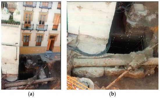
Figure 21.
Photographs of the archaeological excavation at the Puerta Real, by Óscar Ramírez, 1995. Urban Planning Management, Seville City Council: (a) Excavated area next to the remains of the city wall. (b) Detail with foundation remains.
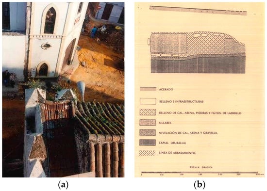
Figure 22.
Archaeological excavations at the Puerta Real, Urban Planning Management, Seville City Council (1995): (a) Top view from the existing city wall—photograph by Óscar Rámirez; (b) Section with foundations from the 16th century. Archaeologists: Óscar Ramírez and Juan Manuel Vargas.
Photographs of the plots of land in Goles Street next to the wall rebuilt around 1990 were also found on the website of the Urban Planning Department (Figure 23). The wall of the eastern façade and one of the buttresses of the apse of the Church of San Laureano can be seen on the existing wall remains. As mentioned above, these buildings did not appear on Olavide’s map of 1771 and could date from the early 19th century. Another photograph consulted shows the remains of an old water drainage system for the city on these plots, which confirms that they were once public spaces.
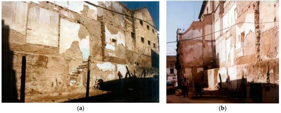
Figure 23.
Photographs of demolished houses near Puerta Real, at 3 Goles Street, next to the San Laureano building and remains of the city wall, 1990. Urban Planning Management, Seville City Council [available online: https://www.urbanismosevilla.org/areas/proyectos-y-obras/publicaciones/fototeca/muralla (accessed on 15 April 2023)]: (a) View to the north; (b) View to the south.
3.2. Digital Documentation: Virtual Modelling
3.2.1. Documentation and Analysis of Existing Archaeological Remains
Another crucial outcome of this research is the rigorous graphic documentation of the wall remains visible today next to the gate. They show two levels with battlements corresponding to two different historical periods. In other words, the wall was built on top of the existing wall then. The remains preserved in Goles Street have also been modelled. Those materials seem to be ancient brick, lime mortar, and river sand and gravel rendering.
The point cloud data processing and 3D reconstruction approach explained in Section 2.2.2 yielded 3D meshes of the existing wall remains. They are displayed in Figure 24 with a detail of their wireframe geometry and visualisation using game-engine technology (Figure 24). Also, quantitative data on the mesh geometry of wall sections (a) and (b) are gathered in Table 1.
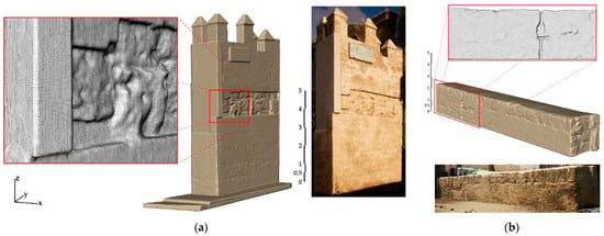
Figure 24.
Graphic documentation of Puerta Real urban environment wall remains (3D mesh geometry and realistic rendering). Authors’ work, 2023: (a) Adjacent to Puerta Real; (b) Goles Street.

Table 1.
3D mesh geometry of wall remain sections.
3.2.2. Recreation of the Puerta Real in Its Current Environment
To ensure that specialists and all types of public understand the Puerta Real, it is helpful to approach its surroundings from a perceptual perspective. The well-known ideas of Kevin Lynch and Gordon Cullen [27,28] facilitate the heritage perception of the urban landscape, as viewed by any citizen, considering the routes taken by the observer and the main elements or landmarks of each area observed.
In this regard, a key visual outcome of this research benefits from the use of modern computer technology commonly employed in the gaming industry. By identifying the preserved archaeological remains, the 3D model from the reconstruction of the disappeared 16th-century Puerta Real was inserted into the point cloud representing the current state of the area (Figure 25).

Figure 25.
3D point cloud as seen from the outside, including the location of the 3D reconstructed Puerta Real. Authors’ work, 2023.
From this digital setting, various other representative points of view were selected as a visual synthesis to ease the understanding of the urban scenario. In an image from outside the historic centre (Figure 26), the San Laureano building appears on the left of its promontory and the right of the buildings resulting from the alignment maps of the early 20th century. In the background is the Puerta Real in a depressed topographical position, as shown in some historical images.
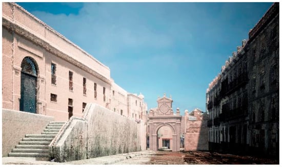
Figure 26.
Graphic recreation of the disappeared Puerta Real seen from the outside, at the beginning of the current Alfonso XII Street, with the San Laureano building on the left. Authors’ work, 2023.
The resulting 3D model was complemented with the proposal by Rafael Manzano in 2006, the opening of two passageways on each side of the city gate (Figure 15b). As indicated by this architect, semi-circular arches were inserted to cover the passageways. However, the height of the arch keystone was set to 4 m to overcome the ground-floor window of the Chapel of Our Lady of Sorrows and to maximise the amplitude impression for pedestrians passing through the passageway. This would also increase the view of the urban environment when crossing the gate. The position and orientation of the former gate were revealed by the archaeological reports and the marked area on both the pavement and road cobblestones, with new floor tiles. Thus, the gate ensemble was aligned with the adjacent wall remain toward the southern façade of San Laureano (Figure 27 and Figure 28).
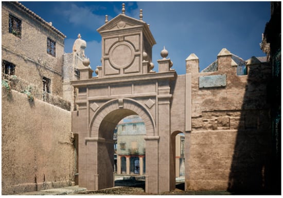
Figure 27.
Graphic recreation of the disappeared Puerta Real seen from the outside, next to the present remains of the city wall. Authors’ work, 2023.
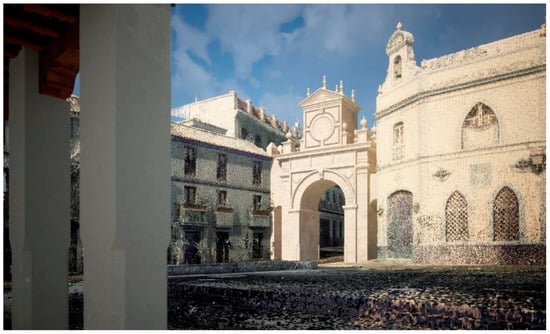
Figure 28.
Graphic recreation of the disappeared Puerta Real seen from the current adjacent square, next to the Chapel of Our Lady of Sorrows. Authors’ work, 2023.
4. Conclusions
This research gathers and analyses a legacy of historical images that, for the first time, highlights the urban environment of a sample of disappeared architectural heritage, the Puerta Real in Seville. These images allow an understanding of urban transformations through the eyes of those who attentively observed this gate in the past in order to represent it. In addition, a digital recreation of this 16th-century gate in its current urban landscape is provided, which aims to approximate the perception of any citizen. All of this is of great interest so that heritage is not considered as a simple object but understood as a superimposition of different historical moments in a given place.
According to the results obtained, which are outlined below, the architect Hernán Ruiz II planned the renovation of Seville’s medieval gates around 1560 as symbols of a city monopolising the trade with America. The Puerta Real, one of the most notable, appeared in numerous images of the city between the 16th and 19th centuries. For this reason, it was analysed in this research. Bambrilla’s engraving of 1585, which was adapted in the Civitates Orbis Terrarum in 1588, and the view by Janssonius, engraved in 1617, were the subject of various plagiarisms that were widely disseminated throughout Europe. The gate was also depicted in two anonymous oil paintings of the 17th and 18th centuries and appeared in the first city map of 1771, copied for military purposes in 1837. Later in the 19th century, it was drawn by important travellers such as Ford and Lungren. Furthermore, around 1855–1860, a few years before its disappearance, Masson photographed it shortly after this graphic technique appeared.
However, the loss of the defensive value of the city walls and gates led to their neglect, as they were seen as an obstacle to progress, and the Royal Gate was demolished around 1864.
Subsequent transformations of the urban environment are reflected in important graphic documents, such as the precise city map of 1870, which details the topography with contour lines. Other alignment maps from the late 19th and early 20th centuries proposed urban layout modifications, although most were not carried out. Another important source for documenting the transformations in the urban hamlet is the aerial photographs available between 1944 and 2008. In addition, graphic documentation of the archaeological excavation carried out by the Seville City Council in 1995 was consulted, which revealed the remains of the foundations of the Puerta Real. Also, special mention should be made of the architect Rafael Manzano’s freehand drawing of 2006, which, using Masson’s photograph, proposed the reconstruction of the Puerta Real for the first time.
This research has shown the important documentary value of the selected historical images, considering their techniques, scales and the interests of their authors (architects, soldiers, travellers, painters, photographers, among others). Although some of those images contain inaccuracies or minor discrepancies, as a whole they are very important for understanding the transformations of the site and the evolution of the social perception of the Puerta Real over time.
The above has been complemented by a virtual recreation of the gate and the site. It is not easy to understand and value heritage that cannot be seen because it has disappeared. For this reason, the authors’ own previous research achieved a basic geometrical recreation of the Puerta Real alone, which has now been revised and completed by incorporating its urban environment and documenting nearby historic city wall remains. Today, despite the proliferation of historical scenes recreated using digital technologies aiming to produce sensations similar to real perception, they do not always meet the desirable scientific accuracy. This work has sought to ensure rigour in the digital recreation, strictly adhering to the graphic, historical and archaeological information available. The rectified Masson photograph, the 19th-century scaled plans located and the existing archaeological remains have been fundamental. In addition, geometric tracings that were frequent in the 16th century were used, as well as treatises on architecture by Serlio, Vignola and the architect Hernán Ruiz himself, who planned the design of the gate.
In addition, a large number of photographs were taken in order to document the urban environment analysed; it was also 3D reconstructed based on the point cloud obtained using 3D scanning technology (TLS). The city wall remains that still exist today were documented with metric rigour. All this proved fundamental in accurately documenting the current state and served as an innovative recreation of the Puerta Real in its surroundings. Advanced computer game technology was used to incorporate textures and lighting, depending on the time of day, into the geo-referenced digital model (Figure 29). Finally, the heritage value of some historical images was considered to select new points of view of interest for their perception by any citizen, taking into account the general guidelines set by UNESCO and Lynch’s or Cullen’s theories, discussed in the introduction.
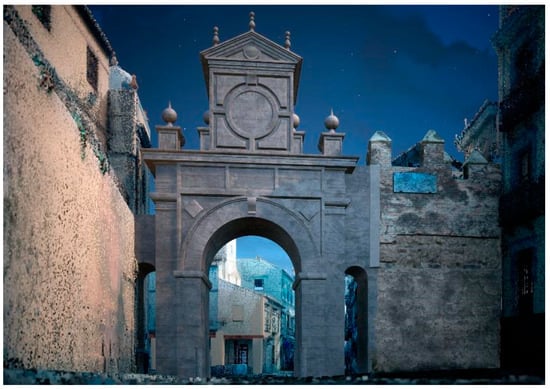
Figure 29.
Graphic recreation of the disappeared Puerta Real seen from outside in the current urban environment at night. Authors’ work, 2023.
Regarding future lines of research, there are other 16th-century gates in the wall of Seville, which also disappeared in the 19th century, which are already being studied. Similar to this work, the methodology will involve identifying and analysing relevant historical images, archaeological data and archive documentation, together with a rigorous graphic recreation of the current urban landscape. GIS technology could also be used to facilitate the linking of the vast amount of data available to 3D models of the gates and their surroundings. In addition, thanks to the video game technology used in this research, the creation of future immersive experiences for citizen dissemination is foreseen.
To conclude, the importance of combining the study of historical images with the most advanced digital techniques should be stressed. The graphic analysis is intended to arouse public interest and debate beyond the research and university spheres. It is hoped that all these images can generate greater awareness in society and the public authorities of the importance of the heritage that has disappeared from its surroundings as a symbol of identity and a possible source of progress. The graphic recreation provided here could go from drawing to built reality. Seville, a historic city, can now reconstruct the missing Puerta Real by the architect Hernán Ruiz II with scientific rigour.
Author Contributions
A.G.-G., D.A. and P.B.-O. participated in the entire research process. All authors have read and agreed to the published version of the manuscript.
Funding
This research received no external funding.
Data Availability Statement
The data presented in this study are available in this article. Data sharing does not apply to this article.
Acknowledgments
This research has been supported by the research group Expregrafica. Lugar Arquitectura y Dibujo (HUM-976); also, by the Instituto Universitario de Arquitectura y Ciencias de la Construcción (IUACC)’s Internationalisation grants from the VII Plan Propio de Investigación y Transferencia, Universidad de Sevilla (Spain). Special thanks to the Gerencia de Urbanismo y Medio Ambiente de Sevilla, particularly to the archaeologist Óscar Rámirez; also to the architect Rafael Manzano Martos, who is a member of the Real Academia de Bellas Artes de San Fernando, Madrid. This research has also been supported by a post-doctoral researcher contract from the VI Plan Propio de Investigación y Transferencia of Universidad de Sevilla (reference VIPPIT-2020-II.5).
Conflicts of Interest
The authors declare no conflict of interest.
References
- International Council of Monuments and Sites. Colloque Sur Le Centre de Documentation de l’ICOMOS/Conference on the ICOMOS Documentation Centre. Available online: https://www.icomos.org/en/116-english-categories/resources/publications/382-colloque-sur-le-centre-de-documentation-conference-on-the-icomos-documentation-centre-1966 (accessed on 10 June 2023).
- Almagro-Gorbea, A. Una Visión Virtual de La Arquitectura de Al-Andalus. Quince Años de Investigación En La Escuela de Estudios Árabes. Virtual Archaeol. Rev. 2011, 2, 105. [Google Scholar] [CrossRef]
- Chías-Navarro, P. Representing the City, the Territory and the Landscape in the Revista Ega: Maps Plans and Drawings. EGA Rev. Expr. Graf. Arquit. 2018, 23, 106–121. [Google Scholar] [CrossRef]
- López-Chao, V.; Amado-Lorenzo, A. Architectural Graphics Research: Topics and Trends through Cluster and Map Network Analyses. Simmetry 2020, 12, 1936. [Google Scholar] [CrossRef]
- Ortega-Vidal, J.; Martínez-Díaz, Á.; Muñoz-de-Pablo, M.J. El Dibujo y Las Vidas de Los Edificios. EGA Rev. Expr. Graf. Arquit. 2011, 16, 50–63. [Google Scholar] [CrossRef]
- Gámiz-Gordo, A. Alhambra. Imágenes de Ciudad y Paisaje; Fundación El Legado Andalusí: Mariana, Spain; Junta de Andalucía: Granada, Spain, 2008; ISBN 9788496395503. [Google Scholar]
- Hidalgo Delgado, F. De Lo Proyectado a Lo Construido. El Mercado Central de Valencia. EGA Rev. Expr. Graf. Arquit. 2012, 19, 114–125. [Google Scholar] [CrossRef]
- Aparicio-Pérez, D.; Del-Blanco-García, F.L. Diseño de Experiencias Inmersivas Para Una Ciudad Utópica. Reconstrucción Gráfica y Virtual de “the Walking City”, Archigram. EGA Rev. Expr. Graf. Arquit. 2022, 27, 98–109. [Google Scholar] [CrossRef]
- Calduch-Cervera, J. El Greco Cartógrafo: Vista Y Plano De Toledo (1608–1614). EGA. Rev. Expr. Gráf. Arquit. 2012, 17, 68–77. [Google Scholar] [CrossRef]
- Pinto-Puerto, F. Modelos Digitales de Información En La Tutela Sostenible Del Patrimonio Cultural. Contribución Al Conocimiento e Innovación Social; Editorial Universidad de Sevilla: Sevilla, Spain, 2022; ISBN 9788447230631. [Google Scholar]
- Murphy, M.; McGovern, E.; Pavia, S. Historic Building Information Modelling (HBIM). Struct. Surv. 2009, 27, 311–327. [Google Scholar] [CrossRef]
- Pascariello, M.I.; Antuono, G. Surveys and New Visions of the Ancient Centre of Naples. Disegnarecon 2022, 15, 29. [Google Scholar] [CrossRef]
- Rodríguez-Miranda, A.; Valle Melón, J.M.; Korro Bañuelos, J.; Elorriaga Aguirre, G. Interactive Virtual Representation of the Disappeared Convent of El Carmen (Logroño) Generated from a Paper Craft Model. Virtual Archaeol. Rev. 2021, 12, 77. [Google Scholar] [CrossRef]
- Einaudi, D.; Spreafico, A.; Chiabrando, F.; Della Coletta, C. Structures: The Turin 1911 Project. Int. Arch. Photogramm. Remote Sens. Spat. Inf. Sci. 2020, XLIII-B2-2, 837–844. [Google Scholar] [CrossRef]
- Boeykens, S.; Himpe, C.; Martens, B. A Case Study of Using BIM in Historical Reconstruction. In The Vinohrady Synagogue in Prague, Proceedings of the 30th eCAADe Conference, Prague, Czech Republic, 12–14 September 2012; Achten, H., Pavliček, J., Hulín, J., Matějovská, D., Eds.; eCAADe (Education and research in Computer Aided Architectural Design in Europe) and CVUT, Faculty of Architecture: Prague, Czech Republic, 2012; Volume 1, pp. 729–738. [Google Scholar]
- Trizio, I.; Demetrescu, E.; Ferdani, D. (Eds.) Digital Restoration and Virtual Reconstructions; Digital Innovations in Architecture, Engineering and Construction; Springer International Publishing: Cham, Switzerland, 2023; ISBN 978-3-031-15321-1. [Google Scholar]
- Smith, M.; Walford, N.S.; Jimenez-Bescos, C. Using 3D Modelling and Game Engine Technologies for Interactive Exploration of Cultural Heritage: An Evaluation of Four Game Engines in Relation to Roman Archaeological Heritage. Digit. Appl. Archaeol. Cult. Herit. 2019, 14, e00113. [Google Scholar] [CrossRef]
- Li, P.; Xiang, J.; Tian, X.; Long, N. Architectural Visualization of Noufu Church Based on Twinmotion. In Proceedings of the 2020 International Conference on Virtual Reality and Visualization (ICVRV), Recife, Brazil, 13–14 November 2020; pp. 322–323. [Google Scholar]
- Demetrescu, E.; D’Annibale, E.; Ferdani, D.; Fanini, B. Digital Replica of Cultural Landscapes: An Experimental Reality-Based Workflow to Create Realistic, Interactive Open World Experiences. J. Cult. Herit. 2020, 41, 125–141. [Google Scholar] [CrossRef]
- Wu, L.; Sun, J.; Wang, J.; Zhang, Y.; Zhang, F. The Design of Virtual Town Based on TwinMotion. In Proceedings of the 2020 International Conference on Virtual Reality and Visualization (ICVRV), Recife, Brazil, 13–14 November 2020; pp. 348–349. [Google Scholar]
- Carbonell-Carrera, C.; Gunalp, P.; Saorin, J.; Hess-Medler, S. Think Spatially With Game Engine. ISPRS Int. J. Geo-Inf. 2020, 9, 159. [Google Scholar] [CrossRef]
- Edler, D.; Keil, J.; Dickmann, F. From Na Pali to Earth—An ‘Unreal’ Engine for Modern Geodata? In Modern Approaches to the Visualization of Landscapes; Edler, D., Jenal, C., Kühne, O., Eds.; Springer: Wiesbaden, Germany, 2020; pp. 279–291. ISBN 978-3-658-30956-5. [Google Scholar]
- Carbonell-Carrera, C.; Saorin, J.L.; Melián Díaz, D. User VR Experience and Motivation Study in an Immersive 3D Geovisualization Environment Using a Game Engine for Landscape Design Teaching. Land 2021, 10, 492. [Google Scholar] [CrossRef]
- Council-of-Europa. The European Landscape Convention (Florence). Available online: https://www.coe.int/en/web/landscape/the-european-landscape-convention (accessed on 10 June 2023).
- UNESCO. Recommendation Concerning the Safeguarding and Contemporary Role of Historic Areas. Available online: https://www.unesco.org/en/legal-affairs/recommendation-concerning-safeguarding-and-contemporary-role-historic-areas (accessed on 10 June 2023).
- Acosta-Bono, G.; Fernández-Cacho, S.; Fernández-Baca, R. El Patrimonio Cultural En La Estrategia de Paisaje de Andalucía. Erph_ Rev. Electrónica Patrim. Histórico 2017, 20, 28. [Google Scholar]
- Lynch, K. The Image of the City; MIT Press: Boston, MA, USA, 1960. [Google Scholar]
- Cullen, G. Townscape; Reinhold Publishing Corporation: New York, NY, USA, 1961. [Google Scholar]
- Montes-Serrano, C.; Alonso-Rodríguez, M. Dibujando El Townscap: En El Centenario de Gordon Cullen. EGA Rev. Expr. Graf. Arquit. 2015, 20, 36–47. [Google Scholar] [CrossRef]
- Campanario, G. The Art of Urban Sketching: Drawing on Location Around the World; Quarry Books: Beverly, CA, USA, 2012; ISBN 9781592537259. [Google Scholar]
- Cortés-Meseguer, L.; Fernández-Plazaola, I. The Architectural Reconstruction or the Resurgence of the Ruins. Archit. Civ. Eng. Environ. 2020, 13, 13–20. [Google Scholar] [CrossRef]
- Solà-Morales, I.; Ramos, F.; Cirici Alomar, C. 1929/1986 Reconstrucción Del Pabellón Alemán de Barcelona. Arquitectura 1986, 261, 4–15. [Google Scholar]
- García-Gutiérrez-Mosteiro, J.; García-Muñoz, J. Acerca de La Puerta (y Las Puertas) de La Latina; Ediciones Asimétricas: Madrid, Spain, 2023; ISBN 978-84-19050-57-1. [Google Scholar]
- Su, X.; Sigley, G.G.; Song, C. Relational Authenticity and Reconstructed Heritage Space: A Balance of Heritage Preservation, Tourism, and Urban Renewal in Luoyang Silk Road Dingding Gate. Sustainability 2020, 12, 5830. [Google Scholar] [CrossRef]
- Valor-Piechotta, M. El Último Siglo de La Sevilla Islámica (1147–1248); Universidad de Sevilla/Gerencia Municipal de Urbanismo de Sevilla: Seville, Spain, 1996; ISBN 978-84-472-0248-5. [Google Scholar]
- Ramírez-Reina, F.O. Las Murallas de La Ciudad. In Patrimonium Hispalense. Historia y Patrimonio del Ayuntamiento de Sevilla; Ayuntamiento de Sevilla: Seville, Spain, 2014; pp. 147–161. ISBN 978-84-92417-97-1. [Google Scholar]
- Lleó-Cañal, V. Nueva Roma. Mitología y Humanismo En El Renacimiento Sevillano; Centro de Estudios Europa Hispánica: Madrid, Spain, 2012; ISBN 9788415245247. [Google Scholar]
- Summerson, J. El Lenguaje Clásico de La Arquitectura; Editorial Gustavo Gili: Barcelona, Spain, 1991. [Google Scholar]
- Serlio, S. Extraordinario Libro di Architettura di Sebastiano Serlio, Architetto del re Christianissimo; Sessa, G.B., Sessa, M., Eds.; Apresso Giouambattista, & Marchio Sessa Fratelli: Venetia, Italy, 1560. [Google Scholar]
- da Vignola, J.B. Regola Delli Cinque Ordini D’architettura; Rome, Italy, 1562. [Google Scholar]
- Sobrino, M. Castillos y Murallas: Las Biografías Desconocidas de Las Fortalezas de España, 1st ed.; La Esfera de los Libros: Madrid, Spain, 2022; ISBN 9788413844213. [Google Scholar]
- Lleó-Cañal, V. Nueva Roma: Mitología y Humanismo En El Renacimiento Sevillano; Excma. Diputación de Sevilla: Seville, Spain, 1979; ISBN 8495139529. [Google Scholar]
- Díaz-Zamudio, T.; Gámiz-Gordo, A.; Valor-Piechotta, M. La Periferia Urbana de Sevilla En Un Plano Inédito de Manuel Spínola (1827). Estud. Geográficos 2019, 80, 286. [Google Scholar] [CrossRef]
- Torres-Balbás, L. Las Murallas Que Caen. Arquitectura 1922, IV, 69–75. [Google Scholar]
- Raya-Rasero, R. Historia Secreta de Los Derribos de Conventos y Puertas de Sevilla Durante la Revolución de 1868; Asademes Ediciones: Seville, Spain, 2006; ISBN 978-84-934765-0-2. [Google Scholar]
- Jiménez-Maqueda, D. Las Puertas de Sevilla. Una Aproximación Arqueológica; Fundación Aparejadores/Ediciones Guadalquivir: Seville, Spain, 1999; ISBN 9788480930758. [Google Scholar]
- Ramírez-Reina, F.O.; Vargas-Jiménez, J.M. Las Murallas de Sevilla: Intervenciones Arqueológicas Municipales. In El último siglo de la Sevilla Islámica: (1147–1248); Valor Piechotta, M., Ed.; Editorial Universidad de Sevilla/Gerencia Municipal de Urbanismo: Seville, Spain, 1996; pp. 83–95. ISBN 978-84-472-0248-5. [Google Scholar]
- Albardonedo-Freire, A.J. El Urbanismo de Sevilla Durante el Reinado de Felipe II; Ediciones Guadalquivir: Seville, Spain, 2002; ISBN 84-8093-115-9. [Google Scholar]
- Mal-Lara, J. Recibimiento Que Hizo La Muy Noble y Muy Leal Ciudad de Sevilla a La C.R.M. Del Rey Don Felipe N.S.; En casa de Alonso Escrivano: Seville, Spain, 1570. [Google Scholar]
- Albardonedo-Freire, A.J. Documentación Sobre La Reforma de La Puerta de Goles (Real) Entre 1560 y 1566. Lab. Arte Rev. del Dep. Hist. del Arte 2000, 13, 11–37. Available online: http://institucional.us.es/revistas/arte/13/01%20albardonero.pdf (accessed on 24 April 2023).
- Mestre-Navas, P.A. Historia Del Colegio de San Laureano de Sevilla: El Arrabal de Los Humeros, El Palacio de Hernando Colón y Los Mercedarios; Editorial Académica Española: Seville, Spain, 2017; ISBN 978-3639665741. [Google Scholar]
- Pozo-Barajas, A. Arrabales de Sevilla. Morfogénesis y Transformación. El Arrabal de Los Humeros. Ph.D. Thesis, Universidad de Sevilla, Seville, Spain, 1994. [Google Scholar]
- Vega-Leal, J.M. 20 Maneras de Entrar En Sevilla; Abec Editores: Seville, Spain, 2013; ISBN 978-84-940592-6-1. [Google Scholar]
- Chaves-Maza, J.L. (Ed.) Puertas de Sevilla Ayer y Hoy; Instituto de la Cultura y las Artes de Sevilla: Seville, Spain, 2014; ISBN 978-84-92417-96-4. [Google Scholar]
- Collantes-de-Terán-Sánchez, A.; Cortes-José, J. Diccionario Histórico de Las Calles de Sevilla; Junta de Andalucía/Ayuntamiento de Sevilla: Seville, Spain, 1993; ISBN 978-84-8095-020-6. [Google Scholar]
- Passolas-Jáuregui, J. Historia de Las Calles, Plazas y Puertas de Sevilla, 1st ed.; Ediciones Ulises: Seville, Spain, 2015; ISBN 8416300224. [Google Scholar]
- Arenas-Rodríguez, P.; Carrasco-Gómez, I.; Conlin-Hayes, E.; Jiménez-Hernández, A.; Lafuente-Ibáñez, P.; Martín-Pradas, A.; Vera-Cruz, E. El Palacio de Hernando Colón: Arqueología de La Arquitectura En El Patio de San Laureano (Sevilla). ROMULA 2002, 3, 285–310. Available online: https://www.upo.es/revistas/index.php/romula/article/view/158 (accessed on 24 April 2023).
- Cortes-José, J.; García Jaén, M.J.; Zoido-Naranjo, F. Planos de Sevilla. Colección Histórica (1771–1918); Ayuntamiento de Sevilla/Editorial MAD S.L.: Seville, Spain, 1992; ISBN 9788486526078. [Google Scholar]
- Olmedo-Granados, F.; Cortés-José, J.A.; Fernández-Gómez, M.; Regidor Jiménez, M.I. Sevilla. Cartografía Histórica. Planos y Mapas, Siglos XVI Al XX; Ayuntamiento de Sevilla: Seville, Spain, 2022; ISBN 9788491021322. [Google Scholar]
- Cabra-Loredo, M.D.; Santiago-Páez, E.M. Iconografía de Sevilla: 1400–1650; Ediciones El Viso/Fundación Focus: Madrid, Spain, 1988; ISBN 84-86022-29-0. [Google Scholar]
- Serrera, J.M.; Oliver, A.; Portús, J. Iconografía de Sevilla: 1650–1790; Ediciones El Viso/Fundación Focus: Madrid, Spain, 1989; ISBN 84-86022-35-2. [Google Scholar]
- Calvo-Serraller, F.; Portús, J.; Carrete-Parrondo, J.; Lleó, V.; Valdivieso, E. Iconografía de Sevilla: 1790–1868; Ediciones El Viso/Fundación Focus: Madrid, Spain, 1991; ISBN 84-86022-45-0. [Google Scholar]
- Ford, B. Richard Ford En Sevilla; Instituto Diego Velázquez/CSIC: Madrid, Spain, 1963. [Google Scholar]
- Rodríguez-Barberán, F.J. La Sevilla de Richard Ford (1830–1833); Fundación el Monte: Seville, Spain, 2007; ISBN 9788496406315. [Google Scholar]
- Rodríguez-Barberán, F.J.; Gámiz-Gordo, A.; Robertson, I. Richard Ford: Viajes Por España (1830–1833); Real Academia de Bellas Artes de San Fernando/Fundacion Mapfre: Madrid, Spain, 2014; ISBN 978-84-96406-31-5. [Google Scholar]
- Jiménez-Maqueda, D. Las Murallas y Sus Puertas. In La Sevilla de Richard Ford, 1830–1833; Fundación el Monte: Seville, Spain, 2007; pp. 166–189. ISBN 978-84-8455-229-1. [Google Scholar]
- Tovar, B. Las Puertas de Sevilla En Dibujos de B. Tovar [1878]; Colegio Oficial de Aparejadores y Arquitectos Técnicos de Sevilla: Seville, Spain, 1978. [Google Scholar]
- Gámiz-Gordo, A.; Barrero-Ortega, P. Imágenes de Un Patrimonio Desaparecido: La Puerta de Triana En Sevilla. EGA Rev. Expr. Gráf. Arquit. 2019, 24, 80–91. [Google Scholar] [CrossRef]
- Gámiz-Gordo, A.; Barrero-Ortega, P. Images of the Disappeared Puerta Real in Seville. In Digital Restoration and Virtual Reconstructions; Trizio, I., Demetrescu, E., Ferdani, D., Eds.; Springer: Cham, Switzerland, 2023; pp. 131–150. ISBN 978-3-031-15321-1. [Google Scholar]
- Galán-Jiménez, J.C.; Gentil-Baldrich, J.M.; Gámiz-Gordo, A. Dibujos de Una Plaza de Toros Neomudéjar En Jerez de La Frontera, 1893. Quiroga 2021, 20, 64–78. [Google Scholar] [CrossRef]
- Gámiz-Gordo, A.; Ferrer-Pérez-Blanco, I.; Reinoso-Gordo, J.F. The Pavilions at the Alhambra’s Court of the Lions: Graphic Analysis of Muqarnas. Sustainability 2020, 12, 6556. [Google Scholar] [CrossRef]
- Pérez-Martínez, J.J.; León-Cascante, Í.; Senderos-Laka, M. Indagación Gráfica y Estudio de Arquitecturas Perdidas: El Palacio Guevara de Segura. EGA Rev. Expr. Graf. Arquit. 2023, 28, 42–55. [Google Scholar] [CrossRef]
- Alonso-Rodriguez, M.; Alvaro-Tordesillas, A.; Carazo-Lefort, E. Infographic Restitution of the Historic Centre of the Spanish Town of Oviedo. Comput. Environ. Urban Syst. 2017, 64, 154–168. [Google Scholar] [CrossRef]
- Antón, D. Ye Olde Trip to Jerusalem, England’s Oldest Pub (Fly-through of VR Immersive Experience). Available online: http://irep.ntu.ac.uk/id/eprint/47661/ (accessed on 9 December 2022).
- Leica Geosystems BLK360 G1 Laser Scanner. Available online: https://leica-geosystems.com/en-GB/products/laser-scanners/scanners/blk360 (accessed on 15 April 2023).
- Antón, D.; Pineda, P.; Medjdoub, B.; Iranzo, A. As-Built 3D Heritage City Modelling to Support Numerical Structural Analysis: Application to the Assessment of an Archaeological Remain. Remote Sens. 2019, 11, 1276. [Google Scholar] [CrossRef]
- Calantropio, A.; Chiabrando, F.; Rinaudo, F.; Teppati Losè, L. Use and Evaluation of a Short Range Small Quadcopter and a Portable Imaging Laser for Built Heritage 3D Documentation. Int. Arch. Photogramm. Remote Sens. Spat. Inf. Sci. —ISPRS Arch. 2018, XLII-1, 71–78. [Google Scholar] [CrossRef]
- Sun, Z.; Zhang, Y. Accuracy Evaluation of Videogrammetry Using A Low-Cost Spherical Camera for Narrow Architectural Heritage: An Observational Study with Variable Baselines and Blur Filters. Sensors 2019, 19, 496. [Google Scholar] [CrossRef]
- Apple Inc. 9th Generation IPad Pro. Available online: https://www.apple.com/ipad-10.2/ (accessed on 15 April 2023).
- Leica Geosystems Cyclone FIELD 360. Available online: https://leica-geosystems.com/products/laser-scanners/software/leica-cyclone/leica-cyclone-field-360 (accessed on 15 April 2023).
- Leica Geosystems Cyclone REGISTER 360. Available online: https://leica-geosystems.com/es-es/products/laser-scanners/software/leica-cyclone/leica-cyclone-register-360 (accessed on 15 April 2023).
- Girardeau-Montaut, D. CloudCompare: 3D Point Cloud and Mesh Processing Software v2.12.4 Kyiv. Available online: http://www.danielgm.net/cc/ (accessed on 15 April 2023).
- Kazhdan, M.; Hoppe, H. Screened Poisson Surface Reconstruction. ACM Trans. Graph. 2013, 32, 1–13. [Google Scholar] [CrossRef]
- Ruiz, H. Libro de Arquitetura; Library ETS Arquitectura: Madrid, Spain, 1569; Available online: https://N9.Cl/Iwiu0 (accessed on 15 April 2023).
- Robert McNeel & Associates. Rhinoceros v5. Available online: https://www.rhino3d.com (accessed on 15 April 2023).
- Chia, A. The Metaverse, but Not the Way You Think: Game Engines and Automation beyond Game Development. Crit. Stud. Media Commun. 2022, 39, 191–200. [Google Scholar] [CrossRef]
- Epic Games Inc. Twinmotion 2023. Available online: https://www.twinmotion.com (accessed on 15 April 2023).
- Braun, G.; Hogenberg, F. Civitates Orbis Terrarum; 1572; Volume I. [Google Scholar]
- Gámiz-Gordo, A.; Díaz-Zamudio, T. Sevilla Extramuros En El Siglo XVI: Tres Vistas Del Civitates Orbis Terrarum. Boletín la Asoc. Geógrafos Españoles 2019, 80, 1–28. [Google Scholar] [CrossRef]
- Braun, G.; Hogenberg, F. Civitates Orbis Terrarum; 1588; Volume IV. [Google Scholar]
- Anonymous Seville Oil Painting [c. 1660; Fundación Focus Seville]. Available online: https://commons.wikimedia.org/wiki/File:Vista_de_Sevilla_1660.jpeg (accessed on 15 April 2023).
- Anonymous Sevilla Oil Painting [Casa Consistorial, City Council of Seville]. Available online: https://commons.wikimedia.org/wiki/File:Vista_de_Sevilla_%28siglo_XVIII%29.jpg (accessed on 15 April 2015).
- EMASESA. El Agua En Sevilla; Ediciones Guadalquivir: Seville, Spain, 1990; ISBN 84-86080-25-8. [Google Scholar]
- Olmedo-Granados, F. (Ed.) Cartografía de Sevilla. Agua y Ciudad; Junta de Andalucía/EMASESA: Seville, Spain, 2014; ISBN 978-84-942807-1-9. [Google Scholar]
- Núñez-González, M. Arquitectura, Dibujo y Léxico de Alarifes En La Sevilla Del Siglo XVI; Editorial Universidad de Sevilla: Seville, Spain, 2021; ISBN 978-84-472-2895-9. [Google Scholar]
- Ford, R. A Hand-Book for Travellers in Spain; John Murray: London, UK, 1845. [Google Scholar]
- Plaza-Orellana, R. Egron Lundgren. Un Pintor Sueco En Sevilla; Diputación Provincial de Sevilla: Seville, Spain, 2012; ISBN 9788477983279. [Google Scholar]
- Fernández-Rivero, J.A.; García-Ballesteros, M.T. Descubriendo a Masson, Fotógrafo En La España Del XIX; Ediciones del Genal: Malaga, Spain, 2018; ISBN 978-8417186104. [Google Scholar]
- Gámiz-Gordo, A. Sobre La Docencia Gráfica de La Arquitectura. Entrevista a Rafael Manzano Martos, Premio Driehaus 2010. EGA Rev. Expr. Gráf. Arquit. 2011, 18, 80–89. [Google Scholar] [CrossRef]
- Núñez-Castaín, J. Sevilla Centro Histórico. La Transformación Radical de Su Imagen Urbana. Génesis y Desarrollo Del Planeamiento Urbano En El Siglo XIX. Ph.D. Thesis, University of Seville, Seville, Spain, 1985. [Google Scholar]
- Vuelos Históricos de Sevilla. Fotos Aéreas 1944–2008. Available online: https://sig.urbanismosevilla.org/Sevilla.art/VisorKML/Sa_visorVUELOS_GU.aspx (accessed on 15 April 2023).
Disclaimer/Publisher’s Note: The statements, opinions and data contained in all publications are solely those of the individual author(s) and contributor(s) and not of MDPI and/or the editor(s). MDPI and/or the editor(s) disclaim responsibility for any injury to people or property resulting from any ideas, methods, instructions or products referred to in the content. |
© 2023 by the authors. Licensee MDPI, Basel, Switzerland. This article is an open access article distributed under the terms and conditions of the Creative Commons Attribution (CC BY) license (https://creativecommons.org/licenses/by/4.0/).