Article

Visibility Evaluation and Suitability Analysis of Fire Lookout Towers in Mediterranean Region, Southwest Anatolia/Türkiye

1
Forest Engineering, Faculty of Forestry, Balıklarkayasi Mevkii, Karabük University, Karabük 78050, Türkiye
2
Geography Department, Faculty of Letters, Demir Celik Campus, Karabük University, Karabük 78050, Türkiye
3
Geography Department, Faculty of Arts and Sciences, Central Campus, Niğde Ömer Halisdemir University, Nigde 51240, Türkiye
*
Author to whom correspondence should be addressed.
Fire 2023, 6(8), 305; https://doi.org/10.3390/fire6080305
Submission received: 9 June 2023 / Revised: 1 August 2023 / Accepted: 4 August 2023 / Published: 7 August 2023
(This article belongs to the Special Issue Mediterranean Fires)

Abstract

:
The effectiveness of fire towers in combating forest fires relies on their appropriate observation angles, enabling a swift and efficient response to fire incidents. The purpose of this study is to examine the effectiveness of 49 fire towers located within the Antalya Forestry Regional Directorate, situated in the Mediterranean basin—a region prone to frequent forest fires. The assessment encompasses the visibility of the entire study area, including forested regions, as well as the visibility of 2504 forest fires recorded by the towers between 2008 and 2021. Furthermore, the evaluation considers the objectives based on Forest Management Directorates and conducts a location suitability analysis for the six towers with the lowest visibility. We utilized the Viewshed Tool in the ArcGIS application and employed the Best–Worst approach. Two scenarios were devised, considering smoke height at 0 m or 100 m, to determine the visibility of fire lookout towers. In Scenario I, assuming a smoke height of 100 m, only three towers exhibited visibility above 70%. However, in Scenario II, assuming a smoke height of 0 m, no towers achieved visibility above 70%. Scenario I indicated that only two towers possessed a view of more than 70% of the forested region, while Scenario II suggested that no towers met this criterion. For the visibility of forest fires, Scenario I identified seven towers capable of observing more than 70%, whereas Scenario II indicated that no towers possessed such capability. In the tower suitability analysis, the visibility rates varied from 41.18% to 1016.67%. Based on the evaluation results, the current visibility capacities of the 49 fire towers proved insufficient for effective preventive measures.

1. Introduction

In ancient times, forest fires were already prevalent, dating back to the Silurian period (approximately 420 million years ago) when plants first emerged on Earth [1,2]. These fires can arise from both human activities and natural occurrences. For instance, during the onset of the Holocene epoch, forest fires in southern Europe were primarily influenced by climatic factors. Notably, the Neolithic era marked the beginning of human-induced fires, as anthropogenic impacts became increasingly significant [3,4]. The global proliferation of forest fires has severely affected forest ecosystems, particularly those characterized by subtropical climates and dry forests, where fire incidence is notably high. This is particularly evident in regions dominated by the Mediterranean Basin ecosystem.
Fire plays a pivotal role in diverse Mediterranean-type ecosystems across the globe, except for the Mediterranean basin, which experiences a notably high frequency of fires [5,6,7,8,9,10]. Within these regions, human-started fires occur frequently. Boreal forests serve as illustrative instances of naturally occurring fires, whereas Mediterranean forests exemplify fires predominantly initiated by human activities [11,12,13]. Notably, an average of 85% of annual fires in Europe transpires within nations encompassing the Mediterranean basin [14,15,16]. One such nation is Türkiye, an Eastern Mediterranean country.
The forested area in Türkiye encompasses approximately 23.1 million hectares, constituting a substantial 29.5% of the country’s total land area. Within these regions, around 20,000 villages and a population of roughly 7,000,000 forest dwellers are found. Responsible for the management of these territories is the General Directorate of Forestry (GDoF), a division under the Ministry of Agriculture and Forestry [17]. The GDoF oversees forest regions across Türkiye through its 30 Regional Directorates of Forestry (RDFs), along with associated Forestry Management Directorates (FMDs) and Forestry Management Chiefship (FMC) operating within these directorates. The interplay of shifting urban demands for forest products and services, as well as the concentration of village populations residing in close proximity to forested areas, has contributed to an increase in human activities within these forest regions. Furthermore, the recreational utilization of these areas by urban residents has seen a rise in recent times.
According to data provided by the GDoF, 117,734 fires were recorded between 1937 and 2021, averaging around 1385 fires annually. Over the same period, these fires devastated approximately 1.8 million hectares of forested land, resulting in an average annual burn of 22,041 hectares. Interestingly, individual fire incidents typically affect a relatively modest area, consuming an average of 15.73 hectares per fire. However, it is evident from the data that human activity is responsible for more than 90% of forest fires [18]. The prevalence of human-induced fires can be attributed to the diverse purposes for which forests are utilized.
“Prevention” serves as the initial and crucial step in the battle against forest fires. The avoidance of forest fires is achieved through the implementation of various measures. One such measure involves the establishment of round-the-clock fire suppression systems throughout forested areas, operating for the entire fire season. Additionally, the early detection of fires within forest regions plays a pivotal role in swiftly controlling them.
In contemporary times, the detection of forest fires has increasingly relied on advanced technologies such as aircraft, uncrewed aerial vehicles (UAVs), wireless sensor networks, and remotely operated vehicles. Nevertheless, it is widely recognized that these technologies cannot completely replace traditional monitoring methods for the foreseeable future. In contrast to airplanes and drones, fire lookout towers continue to serve as a valuable asset in conducting regular surveillance activities. The continuous utilization of drones and aircraft throughout the fire season is economically impractical [19,20]. Therefore, round-the-clock observation remains essential for monitoring high-risk forested areas, mainly where human activity contributes significantly to fire risks. The presence of fire lookout towers emerges as a vital component in effectively controlling and preventing forest fires. It is worth noting that the escalating impact of climate change, characterized by extreme temperatures [21,22,23] and wind patterns [24], has contributed to the rapid spread of forest fires, further underscoring the increasing significance of fire towers within fire management organizations.
Within fire control organizations, two vital aspects take precedence: ensuring the swift and accurate arrival of fire response teams at the fire site, and effectively alerting and guiding these teams regarding the fire’s direction and velocity during firefighting operations. A crucial requirement for the successful implementation of fire control organizations is the proper placement of fire lookout towers, considering optimal visibility angles. When fire lookout towers are strategically located and possess precise calculations accounting for topographic factors, they greatly contribute to early fire control. The utilization of diverse technologies plays a pivotal role in facilitating early fire detection in contemporary times.
In recent years, artificial intelligence, remote sensing, geographic information systems (GISs), and other advanced technologies have significantly accelerated the speed at which fire diagnoses can be made [25,26,27,28]. One noteworthy technique in this regard is visibility analysis, which has proven a critical and practical application for facilitating prompt and early fire detection by fire lookout towers [29,30,31]. It is essential to formulate multifaceted interactions among these components to achieve optimal financial and environmental outcomes. Visibility assessments require various computational techniques [32,33] and topographical considerations [31,34] to arrive at the most optimal solutions. The primary objective of visibility analysis is to maximize the observable area while minimizing the number of required fire lookout towers [32,33,35]. Numerous techniques and methods have been developed to enhance the visibility analysis of fire lookout towers [32,36,37,38,39,40].
In Türkiye, the visibility of fire lookout towers has traditionally not been predetermined. Instead, the construction of fire towers has been based on on-site assessments to determine areas with optimal visibility. However, with advancements in technology, the visibility of fire towers has been subject to systematic study and evaluation over time. Statistical calculations now enable the estimation of visibility regions [30,41,42,43].
The determination of fire lookout tower visibility in Türkiye is under the control of the GDoF. The guidelines for constructing fire towers are outlined in Communiqué No. 285, titled “Implementation Principles in the Prevention and Extinguishment of Forest Fires”, published by the GDoF in 1995. According to this communiqué, the visibility of the towers should be assessed based on specific evaluation criteria. These criteria require that the entire region be visible, accounting for at least 70% visibility, with a maximum distance of 25 km between two fire towers. Additionally, the towers should be positioned to allow them to have mutual visibility. As the GDoF (1995) states, the viewable area extends from the height of the fire smoke up to 100 m [44]. However, it is essential to note that this communiqué does not consider the height of the fire smoke within the visibility scope once it exceeds 100 m. This is because the time interval between the start of the fire and the ascent of smoke to a height of 100 m is crucial for effective fire control operations. Interpreting the visibility concerning this interval would be inappropriate.
Based on statistics covering forest fires in Türkiye from 2012 to 2021, the Antalya Regional Directorates of Forestry ranked first with 6900 hectares affected, followed by the Muğla Regional Directorates of Forestry with 4800 hectares, and the Izmir Regional Directorates of Forestry with 1500 hectares. In terms of fire damage in 2021, the three cities that suffered the most were Antalya (60,400 hectares), Muğla (43,100 hectares), and Mersin (9700 hectares) [18]. The Antalya Regional Directorate of Forestry ranked highest in the magnitude of fire damage in 2021 and also held the top position for the average burnt area over the past decade.
In one study, researchers conducted a visibility analysis of fire lookout towers in the Western Black Sea Region of Türkiye, revealing that 73% of the areas were observable. Introducing new tower proposals expanded the visibility to 81% [30]. In a separate study conducted at the Ilgaz Forest Management Directorate in Türkiye, the visibility analysis of fire lookout towers was conducted using a GIS, determining that 42% of the study area could be observed [41]. Another investigation, carried out in the Köyceğiz Forestry Enterprise Directorate within the Muğla province of Türkiye, entailed a visibility analysis using a GIS. The findings demonstrated that 77.12% of the forest areas were visible from the existing fire lookout towers. Subsequently, through a tower suitability analysis, five additional fire lookout tower proposals were suggested, increasing the visibility of forest areas to 81.47% with the inclusion of the new towers [42].
Given that the Antalya Regional Directorate of Forestry represents one of the most fire-prone regions in Türkiye, it becomes imperative to assess the efficacy of fire lookout towers in this area. Moreover, the significance of forest fire smoke being deemed visible once it reaches a distance of 100 m imposes a critical time constraint on fire control operations, necessitating careful evaluation.
This study aims to concentrate on a comprehensive analysis of the 49 fire lookout towers operating within the purview of the Antalya Regional Directorate of Forestry.
-
Visibility covering the entire work area (general area);
-
Visibility only in forest areas;
-
Visibility of towers for 2504 forest fires that occurred between 2008 and 2021;
-
The analysis conducted for the study takes into account the Forest Management Directorates, considering the three aforementioned objectives);
-
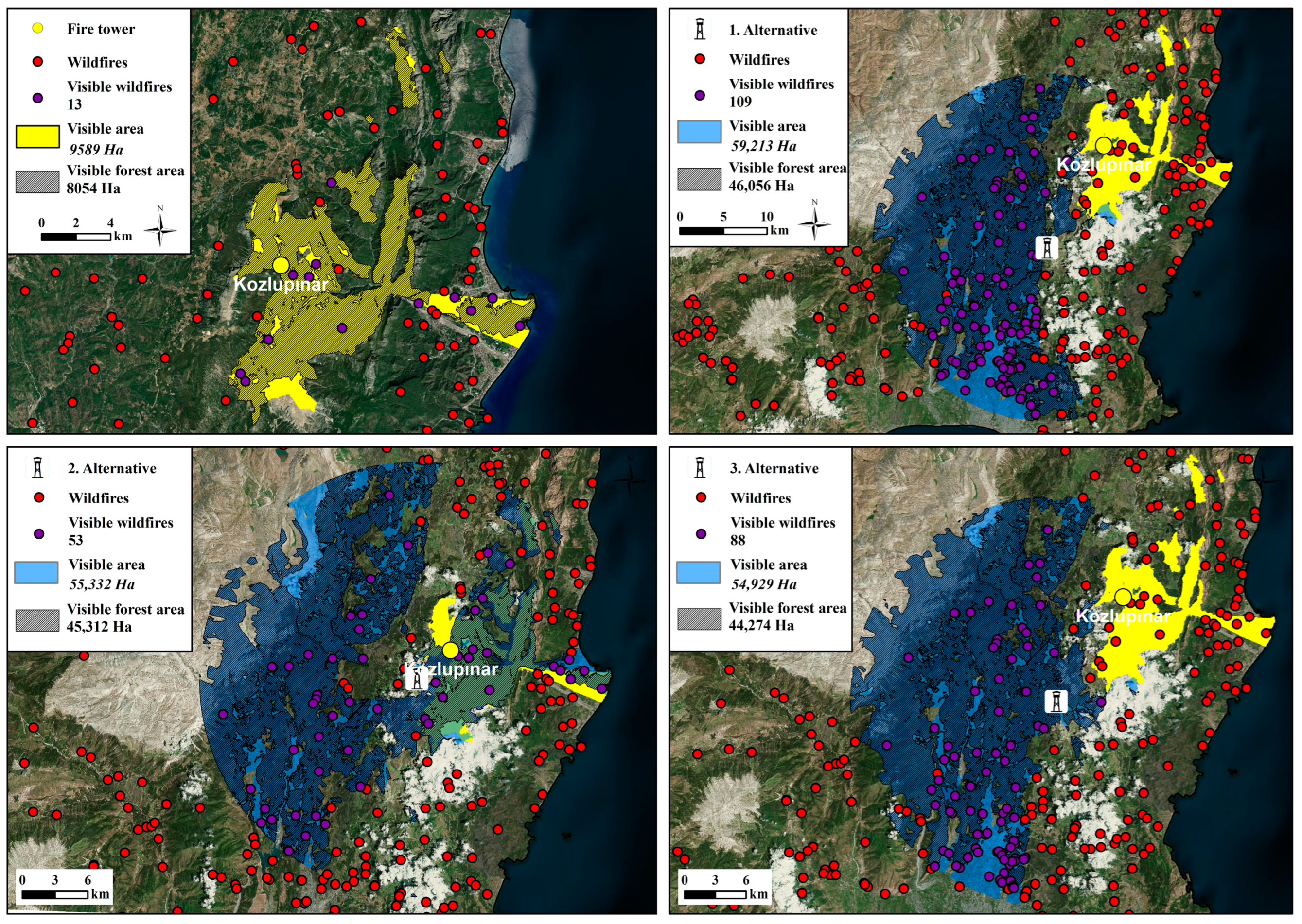
A location suitability analysis has been conducted for the six towers with the lowest visibility.
The study involved the creation of two scenarios to assess the visibility of the towers based on the specified goal. These scenarios were developed considering two different smoke heights: 0 and 100 m. The first scenario was prepared based on the viewable area specified in GDoF Communiqué No. 285, which assumes a smoke height of 100 m. In contrast, the second scenario considered the initial smoke height of 0 m. The reason for creating these two distinct scenarios is that according to Communiqué No. 285, once the smoke height reaches 100 m, the critical period for effective fire control organization has already passed. Considering both scenarios, a comprehensive analysis of tower visibility could be conducted.
According to Scenario I, out of the 49 towers analyzed in the research area, 3 towers exhibit a visibility capacity of above 70% across the entire study region. However, in Scenario II, none of the towers possess this capability. Similarly, when considering the wooded region alone, as per the same communiqué, only two towers meet the criteria of viewing more than 70% in Scenario I, while none meet this requirement in Scenario II. Furthermore, when examining the visibility of the 2504 forest fires that occurred in the vicinity between 2008 and 2021, Scenario I identifies seven towers with the capacity to view 70% or more of these fires. In contrast, Scenario II suggests that no towers possess this capability.
Between 2008 and 2021, most fires, precisely 1969 cases (78.63%), originated within forest regions. Additionally, during the same period, 535 fires (21.37%) initially started outside the forest areas, but eventually spread into them. This indicates that out of every four fires that occurred within the specified timeframe, one originated outside of the forests and subsequently extended into forested regions.
The six towers with the lowest visibility ratio underwent an assessment to determine their appropriateness. As a result of the study, a total of 15,768 potential tower sites were identified for these six towers. Subsequent to the investigation, the towers’ visibility rates increased from 41.18% to 1016.67%. A more comprehensive reorganization of the identification of fire lookout tower positions from previous years should be undertaken using up-to-date technical data.

2. Materials and Methods

Pre-fire investigations encompass the comprehensive evaluation of fire lookout towers, which have been erected with the primary objective of promptly detecting forest fires upon their inception. These research endeavors entail various analyses, with particular emphasis on assessing the visibility range of the aforementioned lookout fire towers.

2.1. Study Area

The study was conducted at the Antalya Regional Directorate of Forestry, located within the geographical coordinates of 29°20′–32°35′ north latitude and 36°07′–37°29′ east longitude (Figure 1). The research site encompasses an ecosystem representative of the Mediterranean region.

2.2. Dataset

The determination of the research area’s elevation and the subsequent visibility assessments were carried out utilizing Digital Elevation Model (DEM) data. In this regard, Global Mapper software was employed to acquire the DEM data with a resolution of 35 m. The fire lookout tower data were procured from the Antalya Regional Directorate of Forestry, as it serves as a critical component for conducting visibility analyses. Based on the obtained data, it was established that the research region encompasses a total of 49 fire lookout towers. To ascertain the fire ignition locations, the coordinates of 2504 fires that transpired within the jurisdiction of the Antalya Regional Directorate of Forestry between 2008 and 2021 were collected using the Geographic Forest Fire Information System (ORBIS) developed by the General Directorate of Forestry [45].

2.3. Mapping Process

The analysis of the study was conducted utilizing the ArcMap 10.4 application. Within this program, the Viewshed Tool was employed to determine the raster surface areas that can be observed from the fire lookout towers. The attribute data table associated with this tool provides relevant parameters, including the height of the observation point, vertical elevation, horizontal and vertical scanning angles, and scanning distances. Moreover, the analysis was confined to a specific raster region of interest. To evaluate the visibility of the fire lookout towers, nine distinct criteria were employed (Table 1, Figure 2).
According to data from the GDoF, Department of Fighting Forest Fires, the height of fire lookout towers varies between 5 and 10 m. Fire observation towers with 360° viewing angles can monitor regions 15 km in diameter without binoculars and 20 km with binoculars. The observation point scanning angle’s lower and upper horizontal values range from 90° to 120°. These results assumed that the elevation of all fire lookout towers in the research region was 10 m, the viewing angle was 360 degrees, and the viewing distance was 20 km.
To obtain data regarding the height and visibility of fire lookout towers, the “GDoF Forest Fire Fighting Department” served as the primary source of information. Interviews were conducted with key personnel within the department, including the Head of Department (one person), Deputy Head of Department (one person), Branch Manager (two people), and technical employees (four people).
Two distinct scenarios were formulated to assess the visibility of the towers, based on different smoke heights. To evaluate the adequacy of tower capacity, towers with a visibility capacity exceeding 70% were considered satisfactory, aligning with the first four objectives of the research. The criterion of a visibility capability exceeding 70% is derived from the principles outlined in GDoF Communiqué No. 285, which serves as the foundational reference.
Following the rigorous visibility calculations, analysis, and mapping conducted for the fire lookout towers, several regions were identified as having enhanced visibility potential for six towers initially characterized by limited visibility. To explore potential alternatives for these towers, a comprehensive study on tower suitability was undertaken, drawing upon the works of Korale et al. [46], Bao et al. [35], Zhang et al. [47], and Sakellariou et al. [48]. Alternatives to these fire lookout towers have been developed to boost visibility and monitor a larger region. The best-of-the-worst technique was initially used to locate acceptable places for fire lookout towers while assessing alternate locations. For the six towers, a 15 km diameter buffer zone was established. Virtual fire towers were discovered one by one using a GIS-created tool. For the first three goals of the research, a visibility analysis was conducted on the alternative fire lookout towers, and tower capacities were established. The area of each determined fire tower was computed, and the results were sorted from greatest to smallest. Three potential tower sites with the highest visibility regions were offered for each fire tower. The places were marked on a map (Figure 3).
As a loop function, the developed tool accepts multiple point data representing virtual towers sequentially, facilitating the calculation of the viewshed based on the available Digital Elevation Model (DEM) data. The resulting viewshed, quantified in terms of hectares, is then stored in a dedicated table. This tool was executed numerous times for all suitable locations, systematically identifying areas with the most optimal visibility.
To conduct the suitability study and propose alternatives for towers with insufficient visibility, various input criteria were calculated. These criteria included height, slope, aspect, curvature, and distance to the towers. These variables were developed within the GIS framework, ensuring a comprehensive and geospatially informed analysis (Table 2).
The tower suitability analysis was conducted using the Best–Worst method, a multi-criteria decision-making technique. This method determined the best (most important) and worst (least important) criteria. These two criteria were then compared with the remaining criteria. Weight values were assigned to the comparison results of all alternatives based on different criteria. To ensure the reliability of these comparisons, the consistency index was employed, following the approach proposed by Rezaei [49]. A consistency index value close to 0 indicates a higher level of consistency and reliability in the obtained weights, as discussed by Badri Ahmadi et al. [50]. The study identified height as the most critical factor in the tower suitability analysis, while curvature was the least important factor. The weights of the parameters and sub-criteria obtained from paired comparisons are presented in Table 2. Once the criterion weights are established using the optimization model based on pairwise comparisons, considering the most and least significant criteria, the model’s accuracy is evaluated by calculating the consistency ratio. The consistency ratio assumes values from 0 to 1 as decimals. Although there is no precise threshold value for the consistency ratio, it is widely acknowledged that the model’s precision improves as this value approaches zero [51,52]. The calculated consistency index value of 0.084 suggests a relatively high level of consistency and dependability in the comparisons made during the analysis.

3. Results

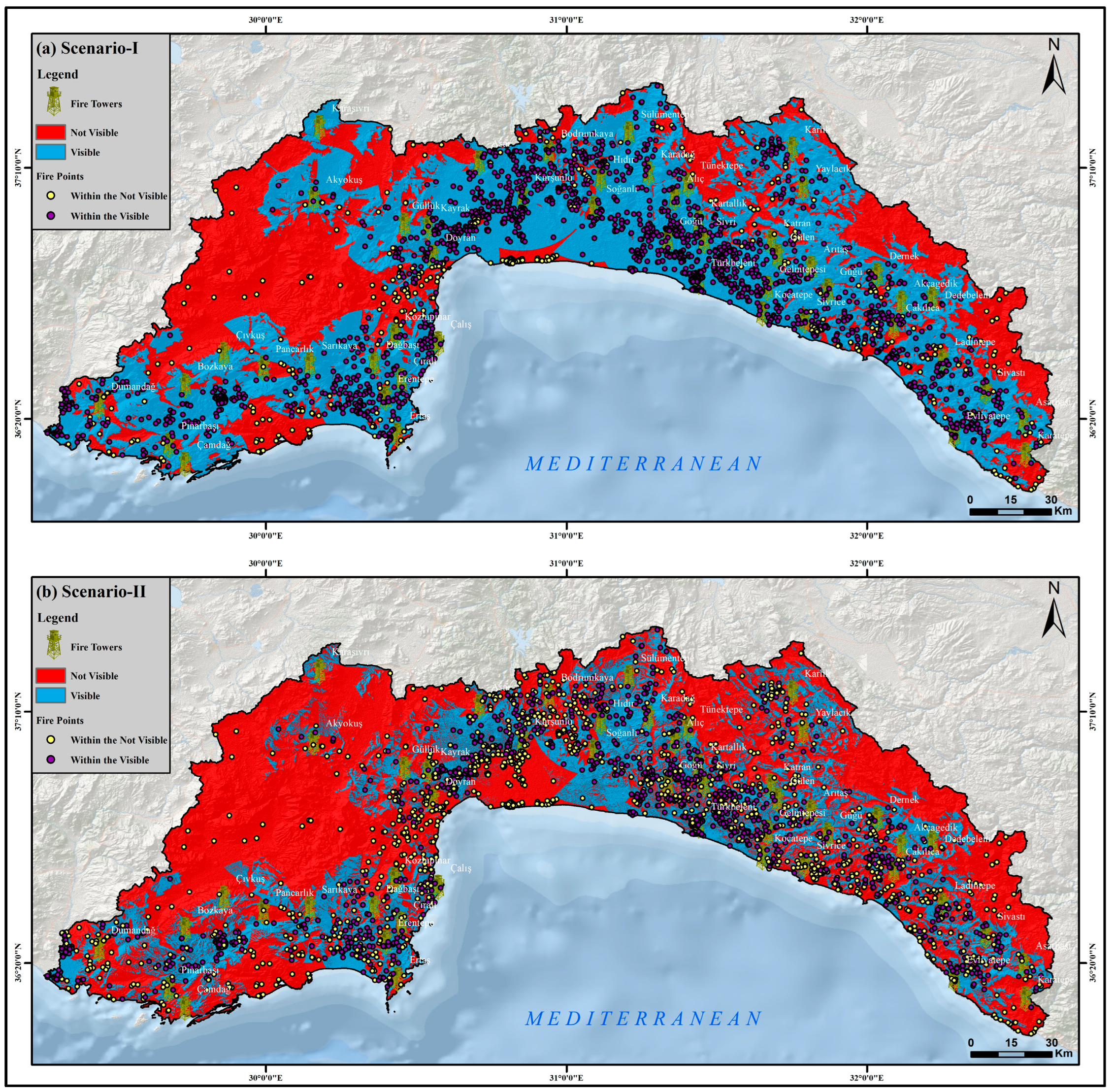
3.1. General and Forest Area Visibility Analysis of Forest Fire Lookout Towers

The analysis conducted under Scenario I revealed that the combined visible area for all 49 forest fire lookout towers within the research region amounted to 1,268,712.2 hectares, representing 61.64% of the total area. Conversely, according to Scenario I, the area that remained outside the visibility range accounted for 789,705.1 hectares, constituting 38.36% of the total area. Among the analyzed towers, Kozlupınar exhibited the lowest total area visibility capacity at 8.9%, whereas Asar boasted the highest general area viewing capacity at 78.3%. Considering the scenario based on GDoF Communiqué No. 285, 3 out of the 49 fire lookout towers, namely, Asar, Kurşunlu, and Türkbeleni, demonstrated a visibility capacity exceeding 70%. Thus, these three towers are deemed to possess satisfactory visibility. Among the total of 49 forest fire monitoring towers assessed, approximately 6.12% were found to possess an acceptable capability level (Figure 4, Table 3).
According to Scenario II, the visible area within the research region amounted to 698,380 hectares, corresponding to 33.93% of the total area. Conversely, the non-visible area accounted for 1,360,037.3 hectares, representing 66.07% of the total area. Among the 49 fire lookout towers assessed, Arıtaş exhibited the lowest general area visibility capability under Scenario II, with a visibility capacity of 2.6%. On the other hand, Asar demonstrated the highest capacity for general area visibility, reaching 46.9%. Following the guidelines outlined in Communiqué No. 285, none of the 49 fire lookout towers possessed a vision capability exceeding 70% (Figure 4, Table 3).
In Scenario I, the analysis focused on the extent to which the 49 towers in the study region can observe the wooded areas. Based on stand data from the Antalya Regional Directorate of Forestry, the total wooded area of the research region, is 1,490,025.6 hectares. According to the study results, the towers have visibility over 577,293.2 hectares (38.74%) of the forest area (Figure 5). Among the 49 towers, Kozlupınar has the lowest forest area visibility capability at 9.30%, while Kurşunlu has the highest forest area visibility capacity at 79.56%. According to the scenario based on Communiqué No. 285, 2 towers (Asar and Kurşunlu) out of the 49 towers have a visibility capacity of more than 70% (Table 3). Therefore, the percentage of towers with adequate capacity among the 49 towers erected for forest fire surveillance is 4.08%.
Scenario II shows that the towers can observe 509,666.1 ha (34.20%) of the forest area (Figure 5). According to Scenario II, Arıtaş has the lowest woodland area visibility of the 49 towers studied, at 3.02%. Asar has the largest forest area visibility capacity, with 39.13%. According to the scenario based on Communiqué No. 285, none of the 49 towers had a visibility capacity of more than 70% (Table 3).

3.2. Vulnerability Analysis of Forest Fires Occurring in General and Forest Areas between 2008 and 2021

According to Scenario I, out of the 2504 forest fires that occurred in the broad region between 2008 and 2021, 2091 (83.51%) were detected in visible areas, while 413 (16.49%) were found in non-visible areas (Figure 6). Among the 49 towers studied, Karasivri and Çıvkuş had the lowest capacity to detect fires in general regions, with 0% and 0.90%, respectively. On the other hand, Asar had the highest capacity to spot fires in general regions, with a rate of 95.30%. Based on Communiqué No. 285, a total of 7 towers (Asar, Bozkaya, Dumandağ, Kartallık, Kurşunlu, Sivri, Türkbeleni) out of the 49 towers had a visibility capacity of more than 70% for general area fires, as shown in Table 3. Therefore, the percentage of towers among the 49 towers erected for forest fire monitoring that could detect fires in general regions was 14.29%.
According to Scenario II, out of the 2504 forest fires that occurred in the broad region between 2008 and 2021, 1190 (47.53%) were located in areas where the fire could be seen, while 1314 (52.47%) were in areas where the fire could not be observed (Figure 6). Among the 49 towers studied, Karasivri and Çıvkuş had the lowest capacity to detect flames in general regions, with 0% and 0.94%, respectively. On the other hand, Bozkaya had the highest capacity to spot fires in general regions, with a rate of 51.63%. There are no towers with tower visibility capacity for fires occurring between 2008 and 2021, according to Communiqué No. 285 (Table 3).
In Scenario I, between 2008 and 2021, 1969 forest fires (78.63%) originated within forest areas. The towers detected 1656 (84.10%) of these fires that started in forest regions (Figure 7). Additionally, 535 fires (21.37%) originated outside the forest areas and spread into forest regions during the same period. Out of all of the forest fires, approximately 16% could not be detected by the towers. Among the 49 towers studied, Karasivri and Çıvkuş had the lowest capacity to spot fires in forest regions, with 0% and 1.02% visibility, respectively. Bozkaya had the highest potential to observe flames in the wooded areas, with a visibility capacity of 94.12%. According to the scenario based on Communiqué No. 285, a total of 8 towers (Asar, Bozkaya, Dumandağ, Kartallık, Kurşunlu, Sivri, Türkbeleni, Akyokuş) out of the 49 towers had a visibility capacity of more than 70% for detecting fires in forest regions. This means that approximately 16.33% of the towers erected for forest fire surveillance could observe fires occurring in forest areas (Table 3).
In Scenario II, it is estimated that the towers were able to observe 1024 (52.00%) of the 1969 fires that started in forest regions between 2008 and 2021 (Figure 7). This means that in this scenario, the towers were unable to detect approximately 48% of the forest fires. Among the 49 towers studied, Karasivri and Çıvkuş had the lowest capacity to spot fires in forest regions, with 0% and 1.02% visibility, respectively. On the other hand, Asar had the highest potential to observe flames in wooded regions, with a visibility capacity of 55.65%. According to Communiqué No. 285, there are no towers with a visibility capacity to detect fires occurring between 2008 and 2021 (Table 3).
According to the analysis of GDoF’s forest fire data from 2008 to 2021, it is found that approximately one out of every four fires that occurred in the forest areas of Antalya Regional Directorate of Forestry started outside the forest areas and then spread into the forest regions.
While the number of fires happening in forest regions and visible from the towers is considerable (84.10%), the quantity of forest area visible from the towers is smaller (38.74%). The explanation for this discrepancy is that the region’s forest regions are at 2000 m or higher heights. On the other hand, the rate of fires between 0 and 1600 m, is 98.76%. This is assumed to be the source of the paradox.

3.3. Visibility Status of Forestry Management Chiefships in Antalya Regional Directorate of Forestry

The research conducted under Scenario I focused on the visibility of forest management directorates’ fire lookout towers in the general area and forested regions. Among the forest management directorates, Antalya, Kaş, Kumluca, Manavgat, Serik, and Taşağıl demonstrated a visibility capacity of more than 70% in the general area. Specifically, Antalya had a visibility rate of 81.70%, Kaş had a rate of 72.78%, Kumluca had a rate of 70.18%, Manavgat had a rate of 96.52%, Serik had a rate of 82.38%, and Taşağıl had a rate of 90.18%. Furthermore, Antalya had a visibility rate of 77.73%, Kaş had a rate of 73.23%, Manavgat had a rate of 94.92%, Serik had a rate of 75.56%, and Taşağıl had a rate of 88.52% in terms of forested area visibility. However, under Scenario II, none of the management directorates achieved a visibility rate exceeding 70% based on the results of the general area and forested area visibility studies.
This study provides the first-ever visibility analysis of 2504 fire-starting locations that occurred within the jurisdiction of the Antalya Regional Directorate of Forestry, conducted by the Forestry Management Directorates between 2008 and 2021. Under Scenario I, the visibility rates of these fires in the general areas, as determined by the respective Forest Management Directorates, are as follows: Akseki at 74.62%, Alanya at 76.41%, Antalya at 81.16%, Gazipaşa at 81.67%, Gündoğmuş at 80.43%, Kaş at 89.52%, Konyaaltı at 71.19%, Kumluca at 89.24%, Manavgat at 98.45%, Serik at 84.47%, and Taşağıl at 97.37%.
Under Scenario I, the visibility rates of Forest Management Directorates for the 1969 fires that occurred in forested regions are as follows: Akseki with 74.56%, Alanya with 76.67%, Antalya with 84.62%, Gazipaşa with 83.02%, Gündoğmuş with 80.95%, Kaş with 88.94%, Konyaaltı with 70.75%, Kumluca with 90.18%, Manavgat with 98.43%, Serik with 83.55%, and Taşağıl with 96.58%.
According to Scenario II, the visibility assessment of fires in the general and wooded areas of the Forestry Management Directorates for the 2504 fires showed that none of the management directors had a visibility rate exceeding 70%.

3.4. Suitability Analysis for Alternative Tower Locations

After completing the study, an evaluation was conducted to determine the suitability of the six towers with the lowest visibility ratios in Scenarios I and II. To create a fire tower suitability map, weight values were assigned using the Best–Worst approach (Figure 8).
A buffer zone of 15 km was determined for the six towers with insufficient visibility. This was to ensure that the alternative towers resulting from the analysis were not close to other existing towers. In the case of the six towers with insufficient visibility, a comprehensive search identified 15,768 potential locations for new tower placements. Among these potential locations, the Best–Worst technique was employed to select three tower points with the highest visibility capacity. The chosen tower sites were then evaluated based on their visibility of the general and forest areas, and the number of fires recorded between 2008 and 2021. The data obtained for these selected tower sites were analyzed as per Scenario I, considering the relevant communiqué. The study’s dependability coefficient was 0.084. When this coefficient is considered, it is clear that the study data have a high level of dependability [49,50].
After the suitability analysis was conducted for the Arıtaş tower, according to Tower Option 1, the overall area that can be seen increased by 416.79%, the forested area increased by 360.17%, and the number of fires increased by 1016.67% (Figure 9).
After the suitability analysis was conducted for the Asarbaşı tower, according to Tower Option 1, the overall area increased by 43.60%, the forested area by 28.99%, and the number of fires by 41.18% (Figure 10).
After the suitability analysis was conducted for the Bodrumkaya tower, according to Tower Option 1, the overall area increased by 370.40%, the forested area by 172.43%, and the number of fires by 413.79% (Figure 11).
After the suitability analysis was conducted for the Çıvkuş tower, according to Tower Option 1, the overall area increased by 131.52%, the forested area increased by 65.50%, and the number of fires increased by 600% (Figure 12).
After the suitability analysis was conducted for the Dedebeleni tower, according to Tower Option 1, the general area increased by 60.07%, the forested area increased by 58.52%, and the number of fires increased by 237.50% (Figure 13).
After the suitability analysis was conducted for the Kozlupınar tower, according to Tower Option 1, the overall area increased by 517.54%, the forested area by 471.84%, and the number of fires by 738.46% (Figure 14).

4. Discussion

Numerous national and international studies have explored the distribution of observable areas by forest fire lookout towers, utilizing data on factors such as tower count, tower heights, smoke height, and visibility. The number of towers considered in these studies varies significantly, with some investigations focusing on 1 to 10 towers [30,41,42,43,53,54,55,56,57,58,59], others encompassing 10 to 28 towers [31,46,60,61,62], and one specific research examining a larger set of 68 towers [63]. In our present study, a comprehensive analysis was conducted on a total of 49 forest fire lookout towers.
In previous research, the reported tower heights have exhibited variability, spanning from 3 to 9 m in various investigations [30,41,42,43,57,59,61,64]. However, a distinct study by Sringeswara et al. [56] considered tower heights between 25 and 30 m. For our present study, the tower height was set at 10 m, aligning with the expert recommendations provided by the GDoF (General Directorate of Forestry) Department of Fighting Forest Fires.
The significance of visibility distance in forest fire lookout tower studies has been underscored in prior research [28,30,47,56,57,59,61,63,64]. Numerous analyses have been conducted to ascertain the effective observation distance of the towers, with a range of 22–35 km explored in certain investigations [43,65]. Following the recommendations of specialists from the GDoF Forest Fire Fighting Department, the approved visibility distance for this study was established at 20 km. This distance was deemed suitable for the research objectives and the specific context under consideration.
The smoke height, a crucial parameter in visibility studies of forest fire lookout towers, significantly influences the analysis. Prior studies have consistently reported a smoke height of 100 m as the standard in the visibility analysis of towers [30,42,43,54,57,59,61,64]. Nevertheless, different research conducted a comparative exploration using three distinct scenarios with smoke heights of 20 m, 50 m, and 100 m [63]. Despite the diversity in these findings, most national publications on this subject continue to uphold the use of a smoke height of 100 m as the prevailing standard.
Numerous studies have investigated the ratio between fire lookout towers and their observable area in relation to forest regions. These investigations have yielded visibility capabilities ranging from 27% to 77% of the overall region [30,41,42,43,54,55,57,60,61,62]. Our study found that the visibility rate for all 49 towers across the study region was 61.64% in Scenario I and 33.93% in Scenario II. These results demonstrate the consistency of our data with previous research concerning the visibility capabilities of fire lookout towers.
The research analyzed in this study has provided insights into the visibility rates of forest regions, which have been observed to vary from 26% to 47% in prior investigations [53,57,59]. A separate study on towers near the research regions reported a relatively improved visibility rate of 59% for wooded areas [61]. In our current study, we determined that the capacity of the towers to observe forest regions was 38.74% for Scenario I and 34.20% for Scenario II. These findings align with previous research, underscoring the insufficiency of forest fire lookout towers in adequately observing the general region and wooded areas. Moreover, the 70% vision restriction set by the GDoF emphasizes that most of the evaluated towers cannot meet the required level of observation for the general region and forested areas.
As per the “Fire Management Plan (2020–2024)” conducted by the GDoF Forest Fire Fighting Department, specific details regarding tower height, visibility, smoke height, and the number of towers are not provided. However, generic area visibility capacities are required for fire visibility analysis [66]. The reported visibility rates for general areas in the Alanya, Finike, and Manavgat Forest Management Directorates, which possess Fire Management Plans and fall within the research region, are 48%, 56.6%, and 56.6%, respectively. Moreover, the Antalya Forest Management Directorate conducted a similar analysis focused on two towers, Asar and Kurşunlu, revealing visibility rates for general regions of 70.80% and 51.06%, respectively [66]. In our current study, Scenario I demonstrates that the general area visibility for the Alanya, Finike, and Manavgat Forest Management Directorates stands at 61.94%, 58.76%, and 96.52%, respectively. Conversely, Scenario II indicates that the general area visibility for the same management directorates is 29.48%, 34.81%, and 61.18%, respectively.
According to Scenario I in the study, the forest area visibility for the Forestry Directorates of Alanya, Finike, and Manavgat is reported as 61.19%, 60.83%, and 94.92%, respectively. In Scenario II, the visibility of the forest area for the same management directorates is 30.57%, 35.85%, and 58.73%, respectively. It is essential to highlight that the GDoF’s “Fire Management Plans” do not explicitly encompass the visibility of forest regions by towers.
According to the study’s findings, the general area visibility ratios of Antalya Forest Management Directorate Asar and Kurşunlu towers are 95.29% and 83.29% for Scenario I and 45.88% and 12.68% for Scenario II, respectively. The visibility rates for these towers in Scenarios I and II are 73.15% and 79.56%, respectively. They are 39.13% and 16.15% for Scenario II, respectively.
The published research on forest fire lookout towers has encompassed assessments conducted for specific Forest Management Directorates, including the fire towers within their respective territories. These assessments involved visibility analyses for various towers in different districts, such as Boyabat Forest Management (six towers), Dalaman Forest Management (nine towers), Dursunbey Forest Management (three towers), Ilgaz Forest Management (four towers), and Çankırı Forest Management (three towers). Moreover, the Antalya Regional Directorate of Forestry conducted assessments for a total of 49 towers spread across 14 Forest Management Directorate districts. Recognizing that focusing solely on a single Forest Management Directorate in such research would be inadequate, as it would not offer a comprehensive representation of the entire area, conducting research encompassing the entire region under the jurisdiction of the Regional Directorate of Forestry would be more advantageous. Such a comprehensive approach would facilitate a better understanding and disclosure of the capacities of the towers, enabling a thorough evaluation of their visibility capabilities across the entire area.
Various studies in the literature have suggested the relocation of forest fire lookout towers to enhance visibility in both public and forest areas, leading to significant improvements in observation capabilities. For instance, Kucuk et al. [30]. demonstrated an 8% increase in visibility through modifications in tower positions, while research focused on the Gallipoli Peninsula resulted in a 13.2% expansion of the viewable area with the consideration of five towers [30]. Similarly, Aşkın [54] found that the visibility of Kemalpaşa Mountain increased by 6.57% with the implementation of three additional tower plans. In northern Mexico, Pompa-Garcia et al. [55] observed a remarkable 38% improvement in site visibility using two tower concepts. Additionally, the visibility analysis conducted for the Gemlik Forest Management Chiefship in Bursa demonstrated that installing a second tower led to a 13.84% increase in general area visibility and an 11.63% increase in forest area visibility [43]. The Köyceiz Forest Management Directorate reported a 4.3% enhancement in location visibility by examining five different tower options [42]. Furthermore, the Ilgaz Forest Management Directorate revealed that relocating one tower resulted in a 2% increase in visibility [41]. This study took an innovative approach, considering five main criteria (elevation, slope, aspect, curvature, and distance to towers) along with their sub-criteria to conduct tower suitability analysis and identify alternative tower proposals to enhance visibility rates. The chosen approach prioritized maximizing visibility ratios for each tower, addressing both general and wooded regions and evaluating 2504 fires between 2008 and 2021. While only a few studies have utilized tower suitability analysis to improve visibility, a similar investigation in the Chalkidiki area in northern Greece led to four solutions, resulting in 70% of the region being observable, with option 4 identified as the most cost-effective [48].
Forest fires have been a recurring phenomenon throughout history, presenting an enduring threat that persists to this day. Initially, these fires were primarily ignited by natural factors, but over time, human activities have played an increasingly significant role in their occurrence [2,7,12,67]. In Türkiye, forest fires can be discerned in three main stages: prevention, extinguishment, and rehabilitation. Among these stages, preventive measures take precedence within the fire management framework, as they are deemed the most crucial aspect to address.
Forest fire prevention encompasses the implementation of diverse techniques to avert the initiation and propagation of forest fires. These techniques encompass a multidimensional approach, involving technical, biological, and socioeconomic strategies. Socioeconomic prevention initiatives aim to raise awareness and educate the general population about the significance of forests and their many benefits, with the ultimate goal of forest fire prevention. Biological research delves into the development of fire-resistant forest structures, managing and controlling flammable materials within forest ecosystems, and formulating strategies to regulate forest dynamics in fire-prone regions. On the other hand, technical studies involve monitoring and inspecting fire-prone locations to detect and respond to potential fire threats promptly.
The observation and surveillance of potential fire-prone areas are paramount for fire control organizations, and fire towers play a crucial role in fulfilling this task. These towers are extensively employed in various regions, including the Mediterranean basin and other parts of the world. A wealth of research exists on this subject, particularly on visibility analysis and assessment studies of forest fire lookout towers using various criteria [30,31,48,64]. The literature encompasses studies on tower visibility analysis, capacity determination of the general and forest areas visible from towers, the analysis of suitable alternative tower locations, and assessments for specific small areas or a limited number of towers [46,47].
This study focused on examining 49 fire towers situated within the Antalya Regional Directorate of Forestry, a significant area concerning fire incidents and burned areas in Türkiye’s Mediterranean region. The researchers conducted visibility evaluations by utilizing data from 2504 fire incidents in the study area between 2008 and 2021. Moreover, alternative tower suitability analyses were conducted based on five key criteria. Two scenarios were developed for the investigations: Scenario I assumed a smoke height of 100 m, while Scenario II assumed a smoke height of 0 m. The primary objective was to identify suitable tower locations using rigorous scientific criteria, identifying 15,768 potential tower sites for six towers. A unique aspect of this study was the application of the Best–Worst approach to conduct a three-option visibility study for each of the six towers. This scientific technique had not been previously employed in tower visibility evaluations in Türkiye, thereby contributing to the originality of this work. Additionally, the researchers emphasized that the worldwide literature on this subject had not considered recent fire data, further highlighting the novelty and relevance of this research.
According to the GDoF (General Directorate of Forestry) communiqué, the minimum visibility capacity ratio mandated for forest fire towers is 70%. Therefore, the assessment of general and forest areas covered by the towers and the analysis of the 2504 fires that occurred between 2008 and 2021 were computed based on this prescribed ratio.
Based on the conducted analysis, it has been determined that in Scenario I, the forest fire towers possess the capability to survey approximately 61.64% of the overall region, while in Scenario II, this capacity diminishes significantly to 33.93%. Interestingly, irrespective of whether the smoke height is assumed to be at 100 m or 0 m, the towers’ visibility of the entire area experiences a considerable reduction of approximately 50%. Regarding the woodland areas observable from the towers, in Scenario I, they account for 38.74% of the total, whereas in Scenario II, this figure slightly decreases to 34.20%. It is worth noting that assuming a smoke height of 0 m further compromises the visibility of these wooded regions. In light of these evaluations, it can be deduced that the visibility capability of the 49 towers within the Antalya Regional Directorate of Forestry falls below the mandated threshold of 70%.
When analyzing the origins of fires between 2008 and 2021, it was found that 83.51% of the fires within the general region, according to Scenario I, and 47.53%, according to Scenario II, took place within the visibility capacity of the towers. For fires in forest regions, these percentages were 78.63% and 52%, respectively, under Scenarios I and II. Considering recent forest fires, it was observed that the visibility capabilities of the towers exceeded 70% for both general and forest regions under Scenario I. However, under Scenario II, the visibility rates for both the general and forest areas remained below the 70% threshold.
The GDoF has developed “Fire Management Plans” for the Forest Management Directorates in Türkiye with the highest occurrence of forest fires [66]. The tower visibility studies conducted for these directorates and the tower visibility capacity ratios determined by GDoF for the same entities are below the 70% threshold. In this regard, the findings of both studies are comparable. According to Scenario I, among the 14 Forest Management Directorates within the Antalya Regional Directorate of Forestry, only 42.86% of the directorates have tower visibility capacity ratios exceeding 70% in the general area, and 35.71% in the wooded region. On the other hand, Scenario II indicates that none of the Forest Management Directorates have tower visibility capacity ratios greater than 70% for both general and wooded regions. However, considering past forest fire data, under Scenario I, 78.57% of the Forest Management Directorates have tower visibility capacity ratios of 70% or higher in general and wooded regions. Despite this, it should be noted that the number of individual towers with sufficient vision capacity is minimal when analyzing the 49 towers individually. The primary reason for this inconsistency is that certain towers oversee territories belonging to different Forestry Management Directorates.
The tower visibility study conducted under Scenarios I and II employed rigorous scientific methodologies, such as slope, aspect, curvature, distance to towers, and elevation, to determine the potential locations for the six towers with the lowest visibility ratios, resulting in 15,768 units. A distinctive aspect of this research was the introduction of a novel approach utilizing the Best–Worst technique to identify alternative tower sites within these areas. The study’s high dependability coefficient of 0.084 further indicates its consistency and credibility, ensuring the reliability of the findings.
Several studies [30,41,43,54,55,60] have examined diverse tower site determinations, revealing varying visibility rates spanning from 2% to 38%. Notably, these studies lacked a rigorous scientific methodology for selecting appropriate tower locations, relying instead on researchers’ subjective preferences. Furthermore, no mention was made of employing a reliability coefficient to assess the robustness and consistency of their findings. In contrast, our investigation demonstrated notable enhancements in both overall and forest area visibility ratios for the six towers with the lowest vision capability. Additionally, visibility rates for past years’ forest fires improved across all towers. The selected towers exhibited substantial enhancement rates, with the general area visibility improving between 43.60% and 517.54%, and the forest area visibility increasing between 28.99% and 471.84%. Notably, the growth in visibility of fire points between 2008 and 2021 ranged from 41.18% to an impressive 1016.67%. As of 2021, the General Directorate of Forestry (GDoF) operated 711 fire towers for surveillance.
Nevertheless, the Fire Management Plans developed for Forest Management Directorates indicated visibility area ratios falling below the recommended threshold of 70%, corroborating the findings of our investigation. Consequently, GDoF’s fire towers fail to achieve effective fire observation, consequently hampering early intervention and extinguishment operations. Moreover, while GDoF regulations permit tower distances of up to 25 km, experts suggest that maintaining a vision distance of approximately 20 km with binoculars could reduce visibility efficiency due to the 5 km unseen region between the towers. Hence, future tower placement studies should carefully consider this aspect to optimize visibility effectiveness.
It is worth noting that the historical tradition of constructing forest fire lookout towers at the highest points of topography aims to provide the widest possible view of the surrounding regions, thus contributing to the efficiency of fire surveillance and management practices.
In light of the rapid technological advancements, it becomes imperative to thoroughly assess locations that offer optimal tower visibility capacity and devise alternative tower placements accordingly. This study presented a concrete demonstration by significantly enhancing the visibility capabilities of six towers with the lowest initial visibility capacity, employing rigorous scientific methodologies. The model applied in this research provides a valuable framework for identifying alternative tower visibility capacities and suitable sites for all towers. Moreover, there is potential for further exploration in conducting an economic analysis of different observation tower locations, which could offer valuable insights and contribute to the improvement of fire surveillance and management practices.

5. Conclusions

The study has conducted a thorough and rigorous assessment of the visual capacity effectiveness of the fire lookout towers under investigation. The visibility capacities of these towers play a critical role in facilitating the swift transmission of fire information to fire control centers, enabling the implementation of effective fire control strategies, and ultimately minimizing the detrimental consequences of forest fires.
The visibility analysis of the fire watch towers in the study area was analyzed using two scenarios depending on the fire smoke height. The visibility capacities of fire lookout towers in the study area, one of Türkiye’s most fire-affected regions, fall below the set standards for both scenario models.
This study has developed a detailed and robust model to enhance tower visibility capacities. A significant improvement was observed by applying the model to the six towers with the lowest visibility capacity. Moreover, the study analyzed the visibility capacities of the starting points of 2504 fires that occurred between 2008 and 2021. These findings are vital for enhancing the effectiveness of fire lookout towers in combating forest fires under the GDoF. The research introduces a novel perspective to the studies on forest fire tower visibility capacities in Türkiye.
Indeed, despite advancements in fire detection methods and technologies, fire watchtowers remain indispensable for detecting forest fires in Türkiye and globally. Hence, continuously evaluating and optimizing the existing fire lookout towers is of utmost importance to enhance their effectiveness in fire detection and control.

Author Contributions

U.C. designed the study, led the writing, and contributed to the acquisition of data; M.C. led the writing and contributed to the manuscript; F.T. prepared the figures and tables, undertook the analysis, and contributed to the manuscript; D.Y. reviewed the literature and contributed to the manuscript; S.C. contributed to the manuscript; E.T. prepared the figures and tables, undertook the tower suitability analysis, and contributed to the manuscript; A.Ö. reviewed the literature and contributed to the manuscript. All authors have read and agreed to the published version of the manuscript.

Funding

This research received no external funding.

Institutional Review Board Statement

Not applicable.

Informed Consent Statement

Not applicable.

Data Availability Statement

The data supporting the findings of this article are available upon request and will be provided in communication.

Conflicts of Interest

The authors declare no conflict of interest.

References

  1. Scott, A.C.; Glasspool, I.J. The diversification of Paleozoic fire systems and fluctuations in atmospheric oxygen concentration. Proc. Natl. Acad. Sci. USA 2006, 103, 10861–10865. [Google Scholar] [CrossRef] [PubMed]
  2. Bowman, D.M.J.S.; Balch, J.K.; Artaxo, P.; Bond, W.J.; Carlson, J.M.; Cochrane, M.A.; D’Antonio, C.M.; DeFries, R.S.; Doyle, J.C.; Harrison, S.P.; et al. Fire in the earth system. Science 2009, 324, 481–484. [Google Scholar] [CrossRef] [PubMed]
  3. Colombaroli, D.; Vannière, B.; Emmanuel, C.; Magny, M.; Tinner, W. Fire-vegetation interactions during the Mesolithic-Neolithic transition at Lago dell’Accesa, Tuscany, Italy. Holocene 2008, 18, 679–692. [Google Scholar] [CrossRef]
  4. Vannière, B.; Colombaroli, D.; Chapron, E.; Leroux, A.; Tinner, W.; Magny, M. Climate versus human-driven fire regimes in Mediterranean landscapes: The Holocene record of Lago dell’Accesa (Tuscany, Italy). Quat. Sci. Rev. 2008, 27, 1181–1196. [Google Scholar] [CrossRef] [Green Version]
  5. Naveh, Z. The evolutionary significance of fire in the mediterranean region. Vegetatio 1975, 29, 199–208. [Google Scholar] [CrossRef]
  6. Gill, A.M.; Groves, R.H.; Noble, I.R. Fire and the Australian Biota; Australian Academy of Science: Canberra, Australia, 1981; Volume viii, 582, ISBN 0858470578. [Google Scholar]
  7. Keeley, J.E.; Keeley, S.C. Chaparral. In North American Terrestrial Vegetation; Cambridge University Press: New York, NY, USA, 1988; pp. 165–207. [Google Scholar]
  8. Richardson, D.M.; van Wilgen, B.W. Ecosystem, Community and Species Response to Fire in Mountain Fynbos: Conclusions from the Swartboskloof Experiment. In Fire in South African Mountain Fynbos: Ecosystem, Community and Species Response at Swartboskloof; van Wilgen, B.W., Richardson, D.M., Kruger, F.J., van Hensbergen, H.J., Eds.; Springer: Berlin/Heidelberg, Germany, 1992; pp. 273–284. ISBN 978-3-642-76174-4. [Google Scholar]
  9. Mohajane, M.; Costache, R.; Karimi, F.; Bao Pham, Q.; Essahlaoui, A.; Nguyen, H.; Laneve, G.; Oudija, F. Application of remote sensing and machine learning algorithms for forest fire mapping in a Mediterranean area. Ecol. Indic. 2021, 129, 107869. [Google Scholar] [CrossRef]
  10. Abujayyab, S.K.M.; Kassem, M.M.; Khan, A.A.; Wazirali, R.; Coşkun, M.; Taşoğlu, E.; Öztürk, A.; Toprak, F. Wildfire Susceptibility Mapping Using Five Boosting Machine Learning Algorithms: The Case Study of the Mediterranean Region of Turkey. Adv. Civ. Eng. 2022, 2022, 3959150. [Google Scholar] [CrossRef]
  11. Johnson, E.A. Fire and Vegetation Dynamics: Studies from the North American Boreal Forest; Cambridge Studies in Ecology; Cambridge University Press: Cambridge, UK, 1992. [Google Scholar]
  12. Ganteaume, A.; Camia, A.; Jappiot, M.; San-Miguel-Ayanz, J.; Long-Fournel, M.; Lampin, C. A review of the main driving factors of forest fire ignition over Europe. Environ. Manag. 2013, 51, 651–662. [Google Scholar] [CrossRef] [Green Version]
  13. Ruffault, J.; Mouillot, F. Contribution of human and biophysical factors to the spatial distribution of forest fire ignitions and large wildfires in a French Mediterranean region. Int. J. Wildl. Fire 2017, 26, 498–508. [Google Scholar] [CrossRef] [Green Version]
  14. Romero-Calcerrada, R.; Barrio-Parra, F.; Millington, J.D.A.; Novillo, C.J. Spatial modelling of socioeconomic data to understand patterns of human-caused wildfire ignition risk in the SW of Madrid (central Spain). Ecol. Model. 2010, 221, 34–45. [Google Scholar] [CrossRef]
  15. San-Miguel-Ayanz, J.; Camia, A. Forest Fires. In Mapping the İmpacts of Natural Hazards and Technological Accidents in Europe an Overview of the Last Decade; EEA Tech. Rep. N13/2010; European Environment Agency (EEA): Copenhagen, Denmark, 2010; ISBN 978-92-9213-168-5. [Google Scholar] [CrossRef]
  16. Nyamadzawo, G.; Gwenzi, W.; Kanda, A.; Kundhlande, A.; Masona, C. Understanding the causes, socio-economic and environmental impacts, and management of veld fires in tropical Zimbabwe. Fire Sci. Rev. 2013, 2, 2. [Google Scholar] [CrossRef] [Green Version]
  17. OGM Ormancılık İstatistikleri, Orman Varlığı 2021. Tarım ve Orman Bakanlığı Orman Genel Müdürlüğü. 2022. Available online: https://www.ogm.gov.tr/tr/e-kutuphane/resmi-istatistikler (accessed on 16 November 2022).
  18. GM 2021 Yılı Orman Yangınları Değerlendirme Raporu. Tarım ve Orman Bakanlığı Orman Genel Müdürlüğü Muğla Orman Bölge Müdürlüğü, Orman Yangınlarıyla Mücadele Şube Müdürlüğü. 2021. Available online: www.ogm.gov.tr/tr/e-kutuphane-sitesi/Pages/Yangin-Yonetim-Planlari.aspx (accessed on 16 November 2022).
  19. Partheepan, S.; Sanati, F.; Hassan, J. Autonomous Unmanned Aerial Vehicles in Bushfire Management: Challenges and Opportunities. Drones 2023, 7, 47. [Google Scholar] [CrossRef]
  20. NPS. Handbook for Fire Lookots; United States Department International National Park Servare: Washington, WA, USA, 1958.
  21. Wotton, B.M.; Flannigan, M.D.; Marshall, G.A. Potential climate change impacts on fire intensity and key wildfire suppression thresholds in Canada. Environ. Res. Lett. 2017, 12, 095003. [Google Scholar] [CrossRef]
  22. Di Virgilio, G.; Evans, J.P.; Blake, S.A.P.; Armstrong, M.; Dowdy, A.J.; Sharples, J.; McRae, R. Climate Change Increases the Potential for Extreme Wildfires. Geophys. Res. Lett. 2019, 46, 8517–8526. [Google Scholar] [CrossRef]
  23. Dowdy, A.J.; Ye, H.; Pepler, A.; Thatcher, M.; Osbrough, S.L.; Evans, J.P.; Di Virgilio, G.; McCarthy, N. Future changes in extreme weather and pyroconvection risk factors for Australian wildfires. Sci. Rep. 2019, 9, 7166. [Google Scholar] [CrossRef] [Green Version]
  24. Ruffault, J.; Curt, T.; Martin-Stpaul, N.K.; Moron, V.; Trigo, R.M. Extreme wildfire events are linked to global-change-type droughts in the northern Mediterranean. Nat. Hazards Earth Syst. Sci. 2018, 18, 847–856. [Google Scholar] [CrossRef] [Green Version]
  25. Xu, G.; Zhong, X. Real-time wildfire detection and tracking in Australia using geostationary satellite: Himawari-8. Remote Sens. Lett. 2017, 8, 1052–1061. [Google Scholar] [CrossRef]
  26. Zhao, Y.; Ma, J.; Li, X.; Zhang, J. Saliency detection and deep learning-based wildfire identification in UAV imagery. Sensors 2018, 18, 712. [Google Scholar] [CrossRef] [PubMed] [Green Version]
  27. Sousa, M.J.; Moutinho, A.; Almeida, M. Wildfire detection using transfer learning on augmented datasets. Expert Syst. Appl. 2020, 142, 112975. [Google Scholar] [CrossRef]
  28. Mistick, K.A.; Dennison, P.E.; Campbell, M.J.; Thompson, M.P. Using Geographic Information to Analyze Wildland Firefighter Situational Awareness: Impacts of Spatial Resolution on Visibility Assessment. Fire 2022, 5, 151. [Google Scholar] [CrossRef]
  29. Alkhatib, A.A.A. A review on forest fire detection techniques. Int. J. Distrib. Sens. Netw. 2014, 10, 597368. [Google Scholar] [CrossRef] [Green Version]
  30. Kucuk, O.; Topaloglu, O.; Altunel, A.O.; Cetin, M. Visibility analysis of fire lookout towers in the Boyabat State Forest Enterprise in Turkey. Environ. Monit. Assess. 2017, 189, 329. [Google Scholar] [CrossRef]
  31. Sakellariou, S.; Samara, F.; Tampekis, S.; Christopoulou, O.; Sfougaris, A. Optimal number and location of watchtowers for immediate detection of forest fires in a small island. Int. J. Agric. Environ. Inf. Syst. 2017, 8, 1–19. [Google Scholar] [CrossRef]
  32. Shi, X.; Xue, B. Deriving a minimum set of viewpoints for maximum coverage over any given digital elevation model data. Int. J. Digit. Earth 2016, 9, 1153–1167. [Google Scholar] [CrossRef]
  33. Zhang, F.; Zhao, P.; Thiyagalingam, J.; Kirubarajan, T. Terrain-influenced incremental watchtower expansion for wildfire detection. Sci. Total Environ. 2019, 654, 164–176. [Google Scholar] [CrossRef]
  34. Eugenio, F.C.; Rosa dos Santos, A.; Fiedler, N.C.; Ribeiro, G.A.; da Silva, A.G.; Juvanhol, R.S.; Schettino, V.R.; Marcatti, G.E.; Domingues, G.F.; Alves dos Santos, G.M.A.D.; et al. GIS applied to location of fires detection towers in domain area of tropical forest. Sci. Total Environ. 2016, 562, 542–549. [Google Scholar] [CrossRef]
  35. Bao, S.; Xiao, N.; Lai, Z.; Zhang, H.; Kim, C. Optimizing watchtower locations for forest fire monitoring using location models. Fire Saf. J. 2015, 71, 100–109. [Google Scholar] [CrossRef]
  36. Franklin, R. Siting Observers on Terrain. In Advances in Spatial Data Handling: 10th International Symposium on Spatial Data Handling; Springer: Berlin/Heidelberg, Germany, 2002; pp. 109–120. [Google Scholar] [CrossRef]
  37. Kim, Y.H.; Rana, S.; Wise, S. Exploring multiple viewshed analysis using terrain features and optimisation techniques. Comput. Geosci. 2004, 30, 1019–1032. [Google Scholar] [CrossRef] [Green Version]
  38. Franklin, W.R.; Vogt, C. Tradeoffs when multiple observer siting on large terrain cells. In Progress in Spatial Data Handling: 12th İnternational Symposium on Spatial Data Handling; Springer: Berlin/Heidelberg, Germany, 2006; pp. 845–861. [Google Scholar] [CrossRef]
  39. Magalhães, S.V.G.; Andrade, M.V.A.; Franklin, W.R. An optimization heuristic for siting observers in huge terrains stored in external memory. In Proceedings of the 2010 10th International Conference on Hybrid Intelligent Systems, Atlanta, GA, USA, 23–25 August 2010; IEEE: Piscataway, NJ, USA, 2010; pp. 135–140. [Google Scholar] [CrossRef]
  40. Ferreira, C.R.; Andrade, M.V.A.; Magalhães, S.V.G.; Franklin, W.R.; Pena, G.C. A Parallel Algorithm for Viewshed Computation on Grid Terrains. J. Inf. Data Manag. 2014, 5, 171–180. [Google Scholar]
  41. Kudu, U.M.; Bugday, E. Yangın Gözetleme Kuleleri Konumlarının Uygunluğunun Değerlendirilmesi (Ilgaz Orman İşletme Müdürlüğü Örneği). Bartın Orman Fakültesi Derg. 2019, 21, 550–559. [Google Scholar]
  42. Akay, A.E.; Wing, M.; Büyüksakalli, H.; Malkoçoǧlu, S. Evaluation of fire lookout towers using GIS-based spatial visibility and suitability analyzes. Sumar. List 2020, 144, 279–288. [Google Scholar] [CrossRef]
  43. Akay, A.E. Assessment of the visibility capabilities of forest fire lookout towers: The case of gemlik, bursa, Turkey. Int. Arch. Photogramm. Remote Sens. Spat. Inf. Sci.-ISPRS Arch. 2021, 46, 27–32. [Google Scholar] [CrossRef]
  44. OGM. Orman Yangınlarının önlenmesi ve Söndürülmesinde Uygulama Esasları: Tebliğ No: 285. 1995. Available online: https://www.ogm.gov.tr/tr/e-kutuphane/mevzuat (accessed on 21 October 2022).
  45. OGM. Koordinatlı Yangın İstatistik Verisi. Orman Genel Müdürlüğü Orman Bilgi Sistemi (ORBİS). 2022. Available online: https://orbis.ogm.gov.tr/orbis/ (accessed on 9 March 2022).
  46. Korale, P.D.; Pade, A.S.; Varghese, A.O.; Joshi, A.K. Mapping of forest fire risk zones and identification of suitable sites for fire watchtowers using remote sensing and GIS. In Proceedings of the ISRS Symposium on Advances in Geo-Spatial Technologies with Special Emphasis on Sustainable Rainfed Agriculture, Nagpur, India, 17–19 September 2009. [Google Scholar] [CrossRef]
  47. Zhang, F.; Zhao, P.; Xu, S.; Wu, Y.; Yang, X.; Zhang, Y. Integrating multiple factors to optimize watchtower deployment for wildfire detection. Sci. Total Environ. 2020, 737, 139561. [Google Scholar] [CrossRef] [PubMed]
  48. Sakellariou, S.; Sfoungaris, G.; Christopoulou, O. Territorial Resilience through Visibility Analysis for Immediate Detection of Wildfires Integrating Fire Susceptibility, Geographical Features, and Optimization Methods. Int. J. Disaster Risk Sci. 2022, 13, 621–635. [Google Scholar] [CrossRef]
  49. Rezaei, J. Best-worst multi-criteria decision-making method. Omega 2015, 53, 49–57. [Google Scholar] [CrossRef]
  50. Badri Ahmadi, H.; Kusi-Sarpong, S.; Rezaei, J. Assessing the social sustainability of supply chains using Best Worst Method. Resour. Conserv. Recycl. 2017, 126, 99–106. [Google Scholar] [CrossRef]
  51. Pamucar, D.; Gigovic, L.; Bajic, Z.; Janoševic, M. Location selection for wind farms using GIS multi-criteria hybrid model: An approach based on fuzzy and rough numbers. Sustainability 2017, 9, 1315. [Google Scholar] [CrossRef] [Green Version]
  52. Mi, X.; Tang, M.; Liao, H.; Shen, W.; Lev, B. The state-of-the-art survey on integrations and applications of the best worst method in decision making: Why, what, what for and what’s next? Omega 2019, 87, 205–225. [Google Scholar] [CrossRef]
  53. Buğday, E. Evaluation of Forest Fire Watch- Towers Location (Çankırı Sample). In Proceedings of the International Congress on Engineering and Life Sciences-ICELIS, Kastamonu, Türkiye, 11–14 April 2019; pp. 518–522. [Google Scholar]
  54. Aşkın, Y. CBS Kullanarak Kemalpaşa Dağı’ndaki Orman Yangın Gözetleme Kulelerinin Görünürlük Analizlerinin Yapılması ve Alternatif Gözlem Noktalarının Saptanması. In Proceedings of the 3. Coğrafi Bilgi Sistemleri, Bilişim Günleri, İstanbul, Türkiye, 6–9 October 2004. [Google Scholar]
  55. Pompa-Garcia, M.; Solís-Moreno, R.; Rodríguez-Téllez, E.; Pinedo-Álvarez, A.; Avila-Flores, D.; Hernández-Díaz, C.; Velasco-Bautista, E. Viewshed Analysis for Improving the Effectiveness of Watchtowers, in the North of Mexico. Open For. Sci. J. 2010, 3, 17–22. [Google Scholar] [CrossRef]
  56. Sringeswara, A.N.; Shivanna, M.B.; Gowda, B. Forest fire and its management in Kudremukh National Park, Western Ghats, India using Remote Sensing and GIS. In Proceedings of the 13th Esri India User Conference, San Diego, CA, USA, 15–19 July 2012; pp. 1–9. [Google Scholar]
  57. Akay, A.E.; Sivrikaya, F.; Yenilmez, N.; Taylan, H. Yangın Gözetleme Kulelerinin Lokasyonlarının CBS Ortamında Görünürlük Analizi İle Değerlendirilmesi. In Proceedings of the 1. Ulusal Akdeniz Orman ve Çevre Sempozyumu, Kahramanmaraş, Türkiye, 26–28 October 2011; pp. 226–233. [Google Scholar]
  58. Akay, A.E.; Erdoğan, A. GIS-Based Multi-criteria Decision Analysis for Forest Fire Risk Mapping. ISPRS Ann. Photogramm. Remote Sens. Spat. Inf. Sci. 2017, 4, 25–30. [Google Scholar] [CrossRef] [Green Version]
  59. Göltaş, M.; Demirel, T.; Çağlayan, İ. Visibility Analysis of Fire Watchtowers Using GIS: A Case Study in Dalaman State Forest Enterprise. Eur. J. For. Eng. 2017, 3, 66–71. [Google Scholar]
  60. Akbulak, C.; Özdemir, M. The Application of the Visibility Analysis for Fire Observation Towers in the Gelibolu Peninsula (NW Turkey) Using GIS. In Proceedings of the Conference on Water Observation and Information System for Decision Support: BALWOIS (Balkan Water Observation and Information System), Ohrid, North Macedonia, 27–31 May 2008; pp. 1–7. [Google Scholar]
  61. Çoban, H.O.; Bereket, H. Visibility analysis of fire lookout towers protecting the mediterranean forest ecosystems in Turkey. Sumar. List 2020, 144, 393–407. [Google Scholar] [CrossRef]
  62. Kavlak, M.Ö.; Kurtipek, A.; Çabuk, S.N. Coğrafi Bilgi Sistemleri İle Orman Yangını Risk Haritası Oluşturulması: Ören Örneği. Resilience 2020, 4, 33–54. [Google Scholar] [CrossRef]
  63. Asri, İ.; Çorumluoğlu, Ö.; Özdemir, E. Uydu Verilerinden Elde Edilmis Sayısal Yükseklik Modeli ile CBS Ortamında Orman Yangın Gözetleme Kulelerinin Görebilirlik Analizi: İzmir Örnegi. In Proceedings of the Türkiye Ulusal Fotogrametri ve Uzaktan Algılama Birliği (TUFUAB) VIII. Teknik Sempozyumu, Konya, Türkiye, 21–23 May 2015; pp. 358–363. [Google Scholar]
  64. Akay, A.E.; Erdoğan, A. Assessment of Fire Watch Towers by using Visibility Analysis: The Case of Dursunbey, Balıkesir. In International Symposium on New Horizons in Forestry; Süleyman Demirel University, Faculty of Forestry Publication: Isparta, Türkiye, 2017; pp. 119–125. [Google Scholar]
  65. Catry, F.X.; Rego, F.C.; Santos, T.; Almeida, J.; Relvas, P. Forest fires prevention in Portugal—Using GIS to help improving early fire detection effectiveness. In Proceedings of the 4th International Wildland Fire Conference, Sevilla, Spain, 14–17 May 2007; pp. 13–17. [Google Scholar]
  66. URL-1 URL-1. Available online: https://www.ogm.gov.tr/tr/e-kutuphane/kitaplik/yangin-yonetim-planlari (accessed on 21 October 2022).
  67. Pausas, J.G. What Is a Fire and What Is a Forest Fire? 2012. Available online: https://www.uv.es/jgpausas/files/PCF_DECALOGUE_en.pdf (accessed on 9 March 2022).
Figure 1. Study area.
Fire 06 00305 g001
Figure 2. Visibility analysis items.
Fire 06 00305 g002
Figure 3. In this figure, GIS layers show the criteria used to detect suitable places. The BWM section summarizes the steps of the suitability analysis. The developed tool shows a sequence of operations that takes the conjectural tower points obtained from the suitability analysis one by one with the help of a loop function, processes the viewshed analysis, and finally calculates and sorts the visible area for each point.
Fire 06 00305 g003
Figure 4. Visibility map of the study area according to Scenarios I and II.
Fire 06 00305 g004
Figure 5. Visibility of forest areas according to Scenarios I and II.
Fire 06 00305 g005
Figure 6. Fire visibility capacity of the towers in the general area according to Scenarios I and II.
Fire 06 00305 g006
Figure 7. Visibility of fires in forest areas by towers according to Scenarios I and II.
Fire 06 00305 g007
Figure 8. Suitability map for fire lookouts.
Fire 06 00305 g008
Figure 9. Suitability analysis for Arıtaş tower.
Fire 06 00305 g009
Figure 10. Suitability analysis for Asarbaşı tower.
Fire 06 00305 g010
Figure 11. Suitability analysis for Bodrumkaya tower.
Fire 06 00305 g011
Figure 12. Suitability analysis for Çıvkuş tower.
Fire 06 00305 g012
Figure 13. Suitability analysis for Dedebeleni tower.
Fire 06 00305 g013
Figure 14. Suitability analysis for Kozlupınar tower.
Fire 06 00305 g014
Table 1. Items specified for attribute table.
ItemsMeaning
SPOTHeight of the observation point above sea level
OFFSETAHeight of the observation point
OFFSETBSmoke height
AZIMUT1Start of observation point scanning angle
AZIMUT2End of observation point scanning angle
VERT1Upper horizontal angle limit of the observation point scanning angle
VERT2Lower horizontal angle limit of the observation point scanning angle
RADIUS1Start of observation point visibility range
RADIUS2End of observation point visibility range
Table 2. Factors used for alternative fire tower suitability analysis and weight values of sub-criteria.
FactorWeightsSub-CriteriaWeights
Elevation
(m)
0.4770–2501
250–5002
500–7503
750–10004
1000–12505
1250–15007
1500–20009
2000–25007
2500–30635
Slope (°)0.1400–49
4–68
6–107
10–126
12–205
20–254
25–303
30–402
40+1
Aspect0.140Flat9
North3
Northeast5
East5
Southeast7
South9
Southwest7
West5
Northwest5
Curvature0.056Concave7
Flat5
Convex9
Distance to towers (m)0.1870–60839
6083–12,1678
12,167–18,2507
18,250–24,3346
24,334–30,4175
30,417–36,5014
36,501–42,5843
42,584–48,6682
48,668–54,7521
Table 3. Scenario I and Scenario II tower vision capacities (%).
Fire TowersScenario I Scenario II
Visible General Area (%)Visible Forest Area (%)Visible Fire Number (%)Visible General Area (%)Visible Forest Area (%)Visible Fire Number (%)
Akçagedik32.8132.8327.3415.9216.1710.07
Akyokuş44.9048.4881.8211.8515.5654.55
Alıç36.0335.6763.5812.2312.6123.46
Arıtaş9.2710.358.662.573.023.15
Asar78.2673.1593.5546.9339.1355.65
Asarbaşı22.5424.4935.7110.9612.0720.24
Bodrumkaya13.3015.7312.716.087.034.42
Bozkaya57.9860.3594.1230.4329.9650.74
Çakılıca33.3733.4050.6113.0713.0124.39
Çalış37.4735.2242.3718.4716.6820.34
Çamdağ58.2362.0855.3218.1419.7321.28
Çıralı26.0026.4919.8311.1911.769.92
Çıvkuş22.8129.611.0211.4014.641.02
Dağbaşı44.6844.5447.4124.6924.9116.30
Dedebeleni23.1321.8517.2411.7811.018.05
Dernek38.2439.0828.7116.7217.5611.88
Doyran36.7326.4850.007.728.4012.00
Dumandağ60.6858.6972.0033.2629.0545.33
Erentepe59.1254.1966.9331.6824.9533.86
Ertaş54.1147.1454.7931.3422.3635.62
Evliyatepe34.4731.4642.0513.339.9112.50
Gelintepesi49.0445.5755.0015.5914.1419.09
Göğü40.6332.3219.3118.1611.577.93
Güğü38.5643.5931.5813.3915.4312.87
Gülen59.2259.1066.0225.1624.5628.64
Güllük38.7944.3448.9820.3921.8229.93
Hıdır58.9556.2042.6933.7829.2925.73
Karadağ44.6745.0251.4721.5321.6730.15
Karasivri27.1739.030.0013.1919.710.00
Karatepe37.9736.9826.2316.2815.3013.11
Karlık52.9153.6966.0421.7122.3918.87
Kartallık50.1847.5176.6517.2316.1428.40
Katran40.9544.2938.3115.2016.8412.44
Kayrak35.2224.7748.175.945.833.67
Kocatepe52.1140.9351.1911.468.7511.90
Kozlupınar8.949.308.424.584.923.16
Kurşunlu77.4079.5686.8912.4616.1513.52
Ladintepe42.3743.3943.5918.8919.6721.37
Pancarlık32.7331.8868.0315.0214.0432.79
Pınarbaşı42.8846.6950.7912.5313.9011.11
Sarıkaya28.6026.7546.8414.3513.4122.78
Sivastı43.7342.0659.7020.3019.8428.36
Sivri58.6852.8379.9419.9015.6826.74
Sivrice42.4539.4454.559.159.057.14
Soğanlı39.8634.3922.3923.8515.695.97
Sülümentepe46.8346.8545.1921.3421.0419.23
Tünektepe29.3229.9249.6210.4710.8119.08
Türkbeleni77.3267.4786.3017.7117.3024.32
Yaylacık55.0356.8658.2120.9322.0916.42
Disclaimer/Publisher’s Note: The statements, opinions and data contained in all publications are solely those of the individual author(s) and contributor(s) and not of MDPI and/or the editor(s). MDPI and/or the editor(s) disclaim responsibility for any injury to people or property resulting from any ideas, methods, instructions or products referred to in the content.

