Abstract
The present study investigates the effect of climatic parameters, such as air relative humidity and wind speed, on fire spread propagation indexes in the Malekroud Forest, Iran using the FARSITE simulator based on Rothermel’s original fire spread equation. Standard fuel models are used to calibrate the vegetation cover. Sorensen (SC) and kappa () coefficients, as well as the Overestimation Index (OI), are used to estimate the simulation’s accuracy. The results confirm that using both ambient condition data and appropriate fuel models is crucial to reaching reasonable results in fire propagation simulations. The values of the Rate of Fire Spread (ROS), Flame Length (FML), and Fire Line Intensity (FLI) are reported for each particular scenario. The simulation results show that the Sorensen and Kappa coefficient for situations most similar to the real fire reached 0.82 and 0.80, respectively. The investigated fire’s severity is categorized as low-condition fire behavior. The simulation shows that fire propagation falls harshly in the case of air relative humidity by more than 72%, and we will not witness natural fire propagation on a large scale.
1. Introduction
Forest fires are a widespread, frequent, and critical disturbance in worldwide terrestrial ecosystems [,,]. As an increasingly common natural disaster, wildfire hazards have affected all the world’s countries [,,,]. In addition, the potential of climate change and global warming, an ongoing challenge in today’s world, can increase the risk of forest fires due to a combination of rising forest temperatures and the drying of forest fuels [,,,]. A similar increase in the global trend of forest fires is happening in Iran. Several studies have been conducted to detect high-risk fire areas, especially in the northern forests of Iran [,,]. Therefore, validating simulation systems before an actual fire can effectively boost the performance of firefighting operations and strategic planning []. Additionally, investigating the effect of weather conditions and vegetation and the nature of fire on the regime of fire spread is of great importance [,].
Wildfire propagation studies have been one of the most critical research topics in recent years [,]. Researchers in this field study the region’s fuel type [,], vegetation [,], and wind speed [,]. The Fire Area Simulator, FARSITE, developed in 1998, is one of the leading fire simulation systems used to describe the spread and behavior of wildland fires []. FARSITE was developed based on Rothermel’s semi-empirical fire prediction model []. The FARSITE fire growth model projects the growth of prescribed natural fires for wilderness areas and requires the support of a geographic information system (GIS) to provide landscape data [,]. Unlike stochastic forest fire growth models [,], FARSITE generally stimulates the fire’s spatial growth based on Huygens’ elliptical wave propagation principle [,]. Although FARSITE is a Global Simulator and does not need to change the governing equations or solution method for different geographical conditions, it requires the local adjustment of climatic parameters to produce reliable results [,,,]. In several different studies, the capabilities of the FARSITE simulator have been evaluated to investigate the rate of fire spread in topological and climatic conditions [,]. In the studies conducted, it is recommended to analyze the sensitivity of the used model. Naturally, this method increases the accuracy and validity of the study results [,].
Approximately 130 fires occur in the nature of Iran annually, leading to the burning of more than 5400 hectares of pastures and forests []. Fires burn more than 300 ha annually in the 1.2 million ha of temperate forest in the north of Iran []. The human factor plays a major role in these northern Iran fires, which is the study site [,]. Besides climatic parameters, topography and anthropogenic factors affect wildfire occurrence [,]. Forest fires primarily occur due to low vegetation humidity and high wind speeds, which are frequent from August to December, when the forests also have a high vegetation cover. The Malekroud forest around the city of Siahkal in the north of Iran is one of the areas affected by fires at different times [,]. This area has been selected as the study area.
To the best of the authors’ knowledge, no studies have been conducted on the simultaneous effect of the climatic parameters of wind speed and ambient humidity. Therefore, this study simultaneously investigates these parameters in a real fire that occurred in the northern forests of the Alborz mountains. The FARSITE model was used to analyze the environmental parameters, such as air humidity and wind speed, in the Malekroud forest, a remnant of the Caspian Hyrcanian mixed forests. The main aims of this study were to investigate the effects of environmental parameters on a fire spread simulation in the SIAHKAL forest using the FARSITE simulator. In addition, the ability of the FARSITE simulator to evaluate the impact of climatic parameters, such as humidity and wind speed, was also investigated. Moreover, wildfire propagation variables, including the rate of fire spread (ROS), fire line intensity (FLI), and flame length (FML), were analyzed based on standard fuel models in the study domain.
2. Materials and Methods
A fire that occurred in the Malekroud forest near the city of Siahkal on 17 December 2010 was selected as the case study. General information about this fire is given in Table 1. As explained in the previous section, Sorensen and Kappa coefficients were used to evaluate the results of the simulators. To simulate the desired fire in the FARSITE simulator, all the landscape maps (elevation, slope, ground aspect, vegetation fuel, and canopy cover) of the actual state of the study area must first be prepared and processed in ArcGIS software [,,,]. Then, using the software, different climate parameter scenarios are considered to investigate potential fire propagation in the Malekroud forest. By comparing the Sorensen and Kappa coefficients in selected scenarios, the scenario with the highest degree of agreement in terms of wind speed and air relative humidity is determined [,]. The scenarios with the most significant impact on the spread of fire were chosen as an example of the studied scenarios []. Simulated fire behavior maps, including fire spread rate, fire line intensity, and flame length, can be fully operationalized by local fire management officials without further processing [,].

Table 1.
Information required to simulate the Malekroud forest fire [].
The location of the Malekroud forest and a map of the fire barriers in the area are shown in Figure 1. Figure 2 shows the vegetation classification of the Malekroud forest code.
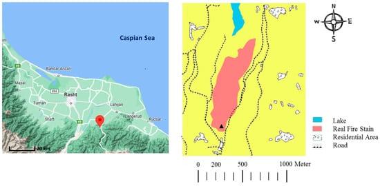
Figure 1.
Location of the Malekroud forest and the map of fire barriers in the area (road, lake, etc.) [].
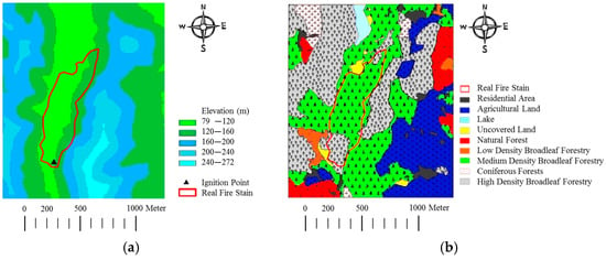
Figure 2.
Elevation map and vegetation classification in the Malekroud forest. The real fire stain is depicted with a red stripe. (Actual resolution of the elevation map used in the simulation is 10 m.) (a): Elevation Map []. (b): Vegetation Classification [].
2.1. Evaluation Indexes
The Sorensen and Kappa coefficients, numbers between zero and one, were considered as criteria for simulation accuracy. As the values of these two coefficients approach one, the simulation results will be closer to the real state [,]. The Sorensen coefficient (SC) is an asymmetric index indicator of the exclusive association between the burned areas (observed and simulated). The Sorensen relation is calculated as follows:
where a is the common area burned in the real and simulated fire, b is the area burned in the simulated fire and the unburned area in the real fire, and c is the area burned in the real fire that is not burned in the simulated fire, all in hectares.
Cohen’s Kappa coefficient () is a standard nonparametric measure of classification accuracy, which allows for evaluating the overall agreement between simulated and actual areas after removing the random agreements by chance []. The Kappa statistical coefficient shows the similarity level of observed spots and simulated fire, calculated in Equation (2) []. This coefficient is a standard non-dimensional parameter for classifying the accuracy of simulations and evaluating the overall agreement between simulated and actual areas [].
where r is the number of rows in the matrix, xii is the number of observations in row i and column i, xi+ is the marginal totals of row i, x+i is the marginal totals of column i, and N is the total number of observations. Table 2 is presented to help understand the accuracy of the simulated fire results with the real fire spot fire results and the interpretation of the Sorensen and Kappa coefficients [,].

Table 2.
Interpretation of matching indexes of simulated fire and the real fire stain for Kappa () and Sorensen (SC) coefficient values [,].
Salis et al. derived an overestimation index (OI) to analyze the primary source of overestimation or underestimation errors in the FARSITE simulator. The OI Index is calculated by Equation (3) and varies between 1 and −1. The highest values show significant overestimation errors, and the lowest value shows underestimation. OI values close to 0 indicate limited differences among overestimated and underestimated cells [].
These introduced indexes will be very effective in management decision making to support current fires or the analysis of past incidents [,,,]. When researchers doubt the best simulation condition with similar SC and κ coefficients, the Overestimation Index can help them choose the best scenarios.
2.2. Metrological Data
To effectively manage the fire and implement preventive measures to reduce the damage caused by the fire, it is necessary to know the type and density of vegetation in the area. Vegetation is a combustible material that affects the ease of fire spread. Vegetation is the most studied of all fire spread agents, and determining all its features is complicated due to its heterogeneity and discontinuity. Among environmental parameters, vegetation is the only factor directly regulated or controlled by management operations. Since it is difficult to describe all vegetation’s physical characteristics, such as load (weight per unit area), size (particle diameter), and mass (weight per unit volume) for all fuels in each area, different classification systems that group different types of vegetation based on fire behavior are used to prepare fuel maps. Since accurate information about local forest fuels is not always available, fire management specialists must rely on standard fuel models. However, it is possible to modify these models according to local conditions based on the experience of forest managers or necessary measurements to obtain more logical results. For example, using the Northern Forest Fire Laboratory system (NFFL), Anderson presented 13 combustible models of standard fire behavior in four flammable fuel groups (Grass, Shrub, Timber, and Slash) [,]. Scott and Burgan also presented 40 new types of fuel models in six categories, including Non-burnable (NB), Grass (GR), Grass–Shrub (GS), Timber–Understory (TU), Timber Litter (TL), and Slash–Blowdown (SB) [].
Fuel models for the study site were chosen by noting the similarities between the existing vegetation characteristics and the estimated components of the available fuels and comparing them with the description of the standard fuel models. Figure 2 shows the general vegetation classification in the study area (Malekroud forest surrounding Siahkal city). As shown in Figure 2, the predominant vegetation in the fire zone is broad-leaved medium-density afforestation. To code the vegetation map into FARSITE, each fuel in the Malekroud Forest was assigned a unique code according to the standard Anderson, Scott, and Burgan fuel classification (Table 3).

Table 3.
Malekroud Forest Fuel Code [].
One of the factors preventing the spread of fire in the region is the existence of roads, lakes, railways, etc.; therefore, it is necessary to identify these fire barriers in the simulation. In some cases, it is possible to estimate the effect of barriers on the rate of fire spread and the fire propagation pattern by considering fire breaks in the FARSITE Simulations. To complete the fire barrier map, the point, line, and polygon maps were separately determined by locating the portion of the Malekroud forest near Siahkal city in Global Mapper software. Then, the files were prepared by Utilizing ArcGIS software shapefiles. Figure 1 shows the area’s road map and other fire barrier factors. The proximity of the combustion starting point to the road and the location of the Malekroud forest between the roads were important refactors for preventing and controlling the spread of the fire in real time. Since the moisture content of live and dead fuels is not available before a fire, the moisture content of dead fuels in 1 h, 10 h, and 100 h classes based on fire environment parameters (climatic factors, topography, and vegetation) was determined using the Rothermel method, according to Table 4.

Table 4.
Parameters of the method used to determine the initial moisture content of dead fuel based on the Rothermel method [,,].
The reference number for the moisture content of the fuel was selected based on the climatic parameters, temperature, and air relative humidity of the study area at the time of the fire []. Additionally, the percentage of the correction of fuel moisture was determined based on other parameters, such as the month and time of the fire, the condition of fuel cover and shading, and the topographic factors elevation, aspect, and slope of the ground. Defined classes for predicting fire behavior severity are presented in Table 5.

Table 5.
Defined classes for predicted fire behavior [].
In addition to the vegetation type and the moisture content of combustible material, which are among the most effective factors in determining the spread of fire in nature and are mostly fixed for a forest area based on the weather conditions, wind speed and air relative humidity are two very influential factors in the forest fire spread. In this case study, these two factors have been examined in detail regarding the Malkroud forest.
3. Results
3.1. Validation Data
The validation section investigates the effects of changing different fuels on fire behavior and the rate of fire spread in the Malekroud forest surrounding Siahkal city. In this section, five simulation scenarios are defined. Scenarios were created by changing the fuel type in the medium- and high-density broadleaf forest. The fuel codes replaced in the real fire scenario were FM9 and FM10. These two types of standard fuels were developed by the Anderson codes and are used for forest areas with high flammability.
The statistical results of the simulation of these scenarios are shown in Table 6. After comparing the Sorensen and Kappa coefficients of the different scenarios, we concluded that the simulation with the highest percentage of agreement with the real fire spot is scenario-V2. Table 5 shows that scenario-V2 produced Sorensen and Kappa coefficients equal to 0.8 and 0.78, respectively, according to the simulation output results. A map of the spread of fire in the study area between the time intervals specified in the FARSITE Simulator shows that scenario-V2 has the highest percentage of agreement with the actual fire spot (Figure 3). It should be noted that in the validation procedure, the hourly wind speed and direction recorded in the meteorological center of Siahkal city have been used for simulation, which is the closest meteorological data regarding the wind speed and direction to the wind spatial data during the fire moment in Malekroud forest, located in Siahkal city. The wind speed and direction are considered fixed through the fire domain for each hour.

Table 6.
Statistical results of the Malekroud forest plant type validation. (a) Common area burned in the real and simulated fire (hectares), (b) Area burned in the simulated fire and unburned in the real fire (hectares), (c) Area burned in the real fire and not burned in the simulated fire (hectares); SC: Sorensen coefficient, : Kappa statistical coefficient, and Overestimation Index.
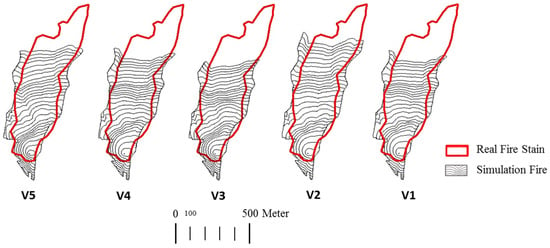
Figure 3.
Fire spread lines between specified time intervals in simulations with different fuels; V1 (TL6, TL9), V2 (FM9, TL9), V3 (TL6, FM9), V4 (TL6, FM10), and V5 (FM9).
In Table 6, the intensity of the fuel types of the study area is compared with the fire behavior classes predicted by Scott and Burgan’s standard fuel model. The model was developed and used to appraise the intensity of fire spread in the fire rating system. The mathematical model applies to a wide range of fuels and is used for predicting the rate of fire spread and intensity.
The values of fire spread rate, fire line intensity, and flame length for different fuel scenarios are provided in Table 7. The maximum value of these parameters was found in scenario V2 with fuel types FM9 and TL9. The intensity of fire behavior, according to Table 5, will be in the low range. The values of the rate of fire spread, flame length, and fire line intensity in the Malekroud forest for the simulation condition of scenario-V1 conditions are presented in Figure 4.

Table 7.
Output values of Rate of Fire Spread (ROS), Fire Line Intensity (FLI), and Flame Length (FML) for validation scenarios.
Figure 4 shows that the typical values of the rate of fire spread, flame length, and fire line intensity in the simulated fire area are in the range of 0.13 < ROS < 0.50, 0.14 < FML < 0.36, and 3.35 < FLI < 63.46, respectively.
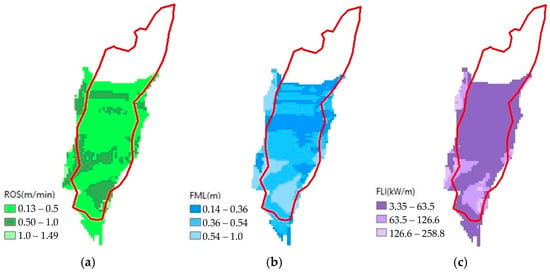
Figure 4.
Results for real simulated fuel (TL6, TL9). (a) ROS: Rate of Fire Spread (m/min), (b) FML: Flame Length (m), and (c) FLI: Fire Line Intensity (kW/m).
All selected scenarios are discussed in Appendix B. In Appendix B, the wind-rose for the Malekroud forest (from 2003 to 2019 from October 26 to January 26) is drawn. Additionally, the annual maximum, average, and minimum temperature values and the yearly maximum, average, and minimum air relative humidity values in the Malekroud forest from 2003 to 2019 are illustrated. Table A2 is the reference scenario table throughout this study.
3.2. Simulation Result
The FARSITE simulations are reported in a range of eight ambient humidity ratio scenarios and nine wind speed scenarios, as defined in Table 8. The Sorensen and Kappa coefficients, rate of fire spread (ROS), fire line intensity (FLI), and flame length (FML) for all 17 considered scenarios are reported.

Table 8.
Sorensen Number (SC), Kappa Number (), Fire Spread Rate (ROS), Fire Line Intensity (FLI), and Flame Length (FML) for different scenarios.
The simulation results show that as the air relative humidity increases, the values of the rate of fire spread, fire line intensity, and flame length and the percentage of its compatibility with the real fire stain decrease. The Sorensen and Kappa coefficients for the first scenario are 0.8 and 0.77, respectively. This scenario shows the highest Sorensen and Kappa coefficients among the eight air relative humidity scenarios.
As explained, the simulations are developed based on the scenarios defined in Table A2. The graphs and contours in Figure 5, Figure 6, Figure 7, Figure 8, Figure 9, Figure 10, Figure 11, Figure 12 and Figure 13 are plotted based on the data in Table 8 and corresponding simulations.
Generally, it should be noted that scenarios are divided into two main categories, fixed air relative humidity and fixed wind speed situations, which are widely demonstrated in Appendix B. Scenarios 1 to 8 belong to simulations with the wind speed fixed at 19.42 km/h, while the relative humidity varies from 2% to 99%. Scenarios 9 to 17 belong to wind speed change simulations for two different air relative humidities equal to 39% (Sc.9 to Sc.12) and 22% (Sc.13 to Sc.17).
The diagrams of the Sorensen coefficient, Kappa coefficient, Overestimation Index, Flame Length, Rate of Spread, and Fire Line Intensity, as well as the fire spread contours for the three main scenario categories, are illustrated in Figure 5, Figure 6, Figure 7, Figure 8, Figure 9, Figure 10, Figure 11, Figure 12 and Figure 13.
Figure 5 and Figure 6 belong to air relative humidity change scenarios with wind speeds equal to 19.42 km/h. Figure 12 and Figure 13 belong to air relative humidity change scenarios with wind speeds equal to 38.62 km/h. In the other category, Figure 7 and Figure 8 belong to wind speed change scenarios with an air relative humidity equal to 39%.
However, the two Sorensen and Kappa coefficients alone cannot be a measure for determining the degree of conformity of the simulated fire with real conditions. Therefore, in addition to these two parameters, the Overestimation Index (OI) should also be taken into account. As seen in Table 8 and Figure 5, Scenario 1 cannot be the optimal scenario due to the high value of the OI index. Although Scenario 2 has slightly lower Kappa and Sorensen coefficients (about 7% less), it is considered a more suitable scenario due to the small value of OI (−0.08). As a result, Scenarios 13 to 17 are chosen with the fixed value of air relative humidity at 22%, while the wind speed changes from 4.82 km/h to 38.62 km/h.
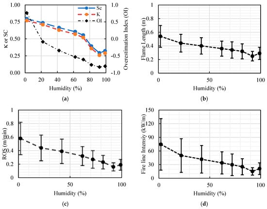
Figure 5.
Result of air relative humidity change scenarios in Malekroud forest; (a) Sorensen coefficient (SC), Kappa coefficient (), and Overestimation Index (OI); (b) Flame Length, (c) Rate of Spread, and (d) Fire Line Intensity. (Error bars mean the parameter varies in a range plus/minus the statistical average value).
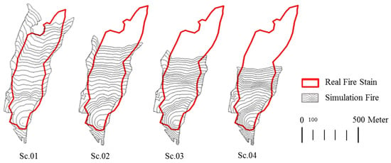
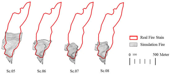
Figure 6.
Fire spread lines between specified time intervals in air relative humidity change scenarios; wind speed is fixed at 19.42 km/h (based on Table A2).
By juxtaposing the shape of the fire spread lines at regular intervals in the scenario Sc.01 simulation of moisture changes, we see that the fire spread lines go beyond the actual fire spot, and the number of fire spread lines decreases as the humidity increases (Figure 6). On the other hand, as the wind speed increases, the simulation of the simulated fire increases compared to the real fire stain. The Sorensen and Kappa coefficients for scenario Sc.12, with a wind speed of 120.70 km/h, are 0.82 and 0.80, respectively. According to Figure 8, the fire spread lines between the specified time intervals for scenario Sc.12 show the highest percentage of agreement with the actual fire stain.
Figure 5 shows the results for air relative humidity change scenarios in Malekroud forest. The Sorensen coefficient, Kappa coefficient, and Overestimation Index have been plotted versus air relative humidity in Figure 7a. Flame Length, Rate of Spread, and Fire Line Intensity are respectively plotted in Figure 7b–d.
Based on the results, according to Figure 5, the rate of spread, flame length, and fireline intensity decrease with the increase in air humidity. The slope of this reduction is sharper at a low humidity, especially for an air relative humidity of less than 22%. For an air relative humidity of more than 72%, the defined class for predicting fire behavior falls into “very low” fire behavior severity based on Table 5 [].
Figure 6, Figure 8 and Figure 12 show the fire spread lines between specific time intervals for different scenarios. These figures especially demonstrate the fire propagation pattern during different climatical conditions qualitatively.
Figure 6 shows the fire spread lines between specified time intervals in the air relative humidity change scenarios for a wind speed of 19.42 km/h (based on Table 8). As shown in Figure 6, and also according to Figure 5a, the Overestimation Index (OI) for the air humidity equal to 22% reaches the nearest value to zero (−0.08). At the same time, Sorensen (SC) and Kappa () coefficients have relatively high values (respectively, 0.74 and 0.70).
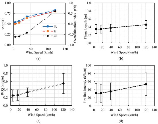
Figure 7.
Result of wind speed change scenarios in Malekroud forest; (a) Sorensen coefficient (SC), Kappa coefficient (), and Overestimation Index (OI); (b) Flame Length, (c) Rate of Spread, and (d) Fire Line Intensity. (Air relative humidity is fixed at 39%.) (Error bars mean the parameter varies in a range plus/minus the statistical average value.)
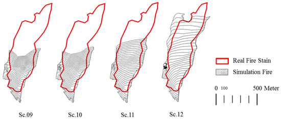
Figure 8.
Fire spread lines between specified time intervals in wind speed change scenarios (based on Table A2). Air Relative Humidity is fixed at 39%, and wind speed values are 4.89, 16.09, 38.63, and 120.70 km/h.
Although in the simulation of scenario number 12, a speed of 120.7 km/h is considered, according to Table 1, the maximum speed observed during the fire in Malekroud forest is much lower than this number and is equal to 33.79 km/h. Therefore, in addition to the very high Overestimation Index (0.61), this scenario cannot be considered a suitable analysis of the simulation results, and researchers should analyze the consequences of Figure 9 and Figure 10 without considering this scenario. Additionally, we can conclude that the rate of spread, flame length, and fire line intensity increases with the air humidity. Among Scenarios 9 to 12, Scenario 11 has the highest consistency with the real condition.
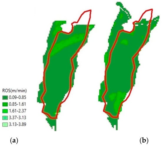
Figure 9.
The rate of fire spread (m/min) for the scenarios with the highest percentage of compliance; (a) changes in wind speed, and (b) changes in air relative humidity.
Similar to Figure 9, Figure 10 shows the result of wind speed change scenarios in Malekroud forest, with an air relative humidity of 39%. Figure 11 shows the fire spread lines between specified time intervals in the air relative humidity change scenarios based on the simulation results.
Figure 9, Figure 10, and Figure 11, respectively, show the rate of fire spread, the flame length, and the fire line intensity values for the scenarios with the highest percentage of consistency with the real fire.
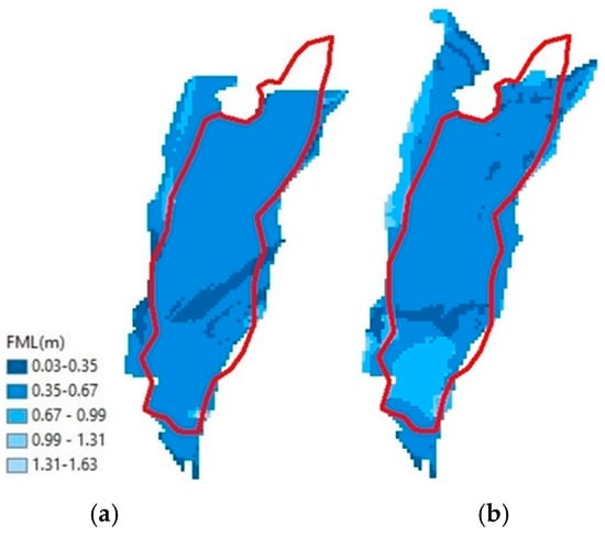
Figure 10.
The Flame Length (m) for the scenarios with the highest percentage of compliance; (a) changes in wind speed and (b) changes in air relative humidity.
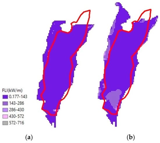
Figure 11.
The Fire Line Intensity (kW/m) for the scenarios with the highest percentage of compliance; (a) changes in wind speed and (b) changes in air relative humidity.
Scenarios 13 to 17 are defined for wind speed change at an air relative humidity of 22%, and Figure 12 and Figure 13 belong to these scenarios. Among Scenarios 13 to 17, Scenarios 14 and 15 have the highest consistency with the real condition, with high Kappa () and Sorensen (SC) coefficient values and a low Overestimation Index (OI). Despite the high-value Kappa coefficient for scenario 15 (0.72), it is ignored because of the high Overestimation Index (0.96). According to Figure 13, although the rate of spread and flame length increase by wind speed, the fire line intensity does not experience a noticeable boost.
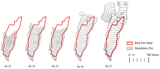
Figure 12.
Fire spread lines between specified time intervals in wind speed change scenarios (based on Table A2). Air Relative humidity is fixed at 22%, and wind speed values are 4.82, 16.09, 19.31, 28.97, and 38.62 km/h.
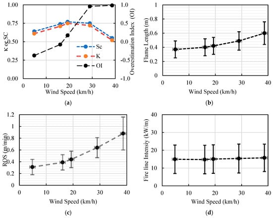
Figure 13.
Result of wind speed change scenarios in the Malekroud forest; (a) Sorensen coefficient (SC), Kappa coefficient (), and Overestimation Index (OI); (b) Flame Length, (c) Rate of Spread, and (d) Fire Line Intensity. (Air relative humidity is fixed at 22%.) (Error bars mean the parameter varies in a range plus/minus the statistical average value.)
The contours of the essential parameters in the simulation are plotted independently. Figure 12 shows the rate of fire spread for the scenarios, with the highest percentage of compliance in scenarios with changes in wind speed and humidity. Similarly, Figure 13 show the flame length and fire line intensity, respectively. The fire spread lines between specified time intervals in wind speed change scenarios with an Air Relative Humidity fixed at 22% are demonstrated in Figure 12 (Scenarios 14 to 18). Additionally, the results for the same scenarios for the Sorensen and Kappa coefficients, flame length, spread rate, and fire line intensity are indicated in Figure 13. Comparing the rate of fire spread in scenarios with changes in humidity and wind speed under the same simulation conditions shows that changes in ambient moisture have the most significant effect on the rate of surface fire spread compared to other parameters.
4. Discussion
According to the simulation results of the air relative humidity scenarios, the high air relative humidity in Malekroud forest at the time of a fire can be one factor preventing the rapid fire spread. In the case of an air relative humidity of more than 42%, the probability of a fire spread rate decreases, and for a relative humidity of air of more than 72%, the fire propagation falls harshly, and we have not witnessed natural fire propagation on a large scale. Considering the high humidity level in the natural broadleaf forests of northern Iran, the possibility of a fire occurring in it due to a single environmental factor alone is minimal. It requires a set of climatic conditions to cause a fire. Among other factors affecting the fire spread in the region, we can mention wind speed and direction parameters. Due to the fire breaks, such as roads and urban areas around the studied area, the effect of these parameters on fire spread is not wholly noticeable. If there were no fire breaks, the effect of the prevailing wind direction in the area on the fire spread could be observed in more detail. The authors’ simulations show that despite the rolling effect of fire breaks on fire propagation patterns, the simulation results are thoroughly conditioned by climatic parameters, especially wind speed and wind direction.
Overall, scenarios are divided into two main categories: wind speed change and air relative humidity change scenarios. The results of air relative change scenarios in Malekroud forest, demonstrated in Figure 5 and Figure 6, show that the rate of spread, flame length, and fire line intensity decrease with the increase in air humidity. The reduction acceleration is much higher at less than 22% air relative humidity. For an air relative humidity of more than 72%, the defined class for predicting fire behavior falls into “very low” fire behavior severity based on Table 5.
The results of wind speed scenarios are demonstrated in Figure 7 and Figure 8. As expected, the rate of spread, flame length, and fire line intensity increase with wind speed. On the other hand, the Sorensen (SC) and Kappa (κ) coefficients, as well as the Overestimation Index (OI), also increase with high acceleration. Increasing the overestimation index to the highest level in all scenarios is not desirable. Three scenarios have the highest consistency with the real condition, with high Kappa (κ) and Sorensen (SC) coefficient values and a low Overestimation Index (OI) (14, 15, and 16). Despite the high-value Kappa coefficient for scenario 16 (more than 0.72), it is ignored because of the high Overestimation Index (0.96).
In the studies conducted mainly in the field of forest fires in the north of Iran, especially regarding Hyrcanian forests, the effect of wind speed and direction parameters, as well as relative air humidity, on the parameters of fire spread has not been investigated so far. Of course, these studies have been conducted in a decentralized manner in other parts of the Middle East, but what distinguishes this study from other studies is the examination of all the essential parameters for describing the behavior of forest fires using simulation evaluation indicators. The combined use of the mentioned indicators and parameters makes it easier for researchers to predict and analyze future fire behavior in Hyrcanian forests.
5. Conclusions
Considering the gap in studies on forest fires in northern Iran, this study simultaneously investigates the simultaneous effect of the climatic parameters of wind speed and ambient humidity in a real fire in the Alborz Hyrcanian forests in northern Iran. This study investigated the effects of climate scenarios, including changes in air relative humidity and wind speed, on the fire behavior and patterns in the Malekroud forest surrounding Siahkal city. The simulation results, including the fire spread rate, flame length, and fire line intensity for each scenario, were calculated and separately compared in the tables embedded in the results section.
Comparing the rate of fire spread in the scenarios of changes in air relative humidity and wind speed under the same simulation conditions shows that changes in air relative humidity have the most significant effect on the rate of fire spread compared to other parameters, including flame length and fire line intensity. The simulation results show that the maximum Sorensen and Kappa coefficients for the scenarios most similar to the real situation were 0.82 and 0.80. The actual fire in the Malekroud forest was classified as low fire behavior severity. Although less commonly used in studies, the authors recommend using the Overestimation Index (OI) to analyze the primary source of errors in the simulations, especially in cases where researchers are uncertain as to which scenarios with relatively similar Kappa and Sorensen numbers they should select.
Recorded atmospheric data such as air temperature, air humidity, and wind speed and direction are recorded hourly (and not in shorter periods) for the Siahkal Meteorological Center (and not for different parts of the region), and this issue leads to uncertainty in the simulation. On the other hand, natural fire breaks limit the possibility of accurately evaluating the simulation results. Simulations show that among a set of conditions that affect fire propagation, considering the high humidity level in the Hyrcanian forests of northern Iran and limitations cussed by natural fire breaks, fire propagation patterns are thoroughly conditioned by climatic parameters.
Author Contributions
Conceptualization, E.M.B., M.N., H.A. and B.F.; methodology, E.M.B. and M.N.; software, M.N. and E.M.B.; validation, E.M.B., M.N. and H.A.; M.N. and E.M.B.; investigation, E.M.B. and M.N.; resources, E.M.B. and M.N.; data curation, E.M.B.; writing—review and editing, E.M.B. and M.N.; visualization, E.M.B.; supervision, M.N., H.A. and B.F.; project administration, E.M.B.; funding acquisition, N/A; All authors have read and agreed to the published version of the manuscript.
Funding
This research received no external funding.
Institutional Review Board Statement
Not applicable.
Informed Consent Statement
Not applicable.
Data Availability Statement
The data that support the findings of this study are available upon request.
Acknowledgments
The authors would like to acknowledge the assistance of Roghieh Jahdi, Assistant Professor at the University of Mohaghegh Ardabili, for her contributions and discussions about the topic.
Conflicts of Interest
The authors hereby declare that they do not have any conflict of interest in the article “Case Study on the Effects of Weather Conditions on Forest Fire Propagation Parameters in the Malekroud Forest in Guilan, Iran”, and this manuscript has not been submitted to, nor is under review at, another journal or other publishing venue. The authors also declare that no funds, grants, or other support were received during the preparation of this manuscript, and they do not have any relevant financial or non-financial interests to disclose. All authors have participated in (a) the conception and design, analysis, and interpretation of the data; (b) drafting the article or revising it critically for important intellectual content; and (c) the approval of the final version.
Nomenclature
| v | Geographic Information System |
| ROS | Rate of Fire Spread |
| FLI | Fire Line Intensity |
| FML | Flame Length |
| T | Temperature |
| t | Time |
| SC | Sorensen Coefficient |
| Kappa statistical coefficient | |
| OI | Overestimation Index |
| Ir | Reaction Intensity—Rate of energy release per unit area of the fire front |
| tr | Duration of presence |
| a | Common area burned in real and simulated fire (hectares) |
| b | Area burned in simulated fire and unburned in real fire (hectares) |
| c | Area burned in real fire and not burned in simulated fire (hectares) |
Appendix A. Wind Simulations
Wind plays an important role in the fire spread rate and propagation pattern. In the first step, before validating the effect of wind speed on fire spread, the authors investigated the impact of wind direction on fire spread. The wind effect in main directions has been studied in the FARSITE simulator according to the wind rose detail. The results are clearly shown in Table A1, the statistical graph in Figure A1, and the fire propagation patterns in Figure A2. As clearly shown in the results, if the hourly effects of wind speed and direction are not considered, the accuracy of the simulation results will be significantly reduced.

Table A1.
Statistical results of the Malekroud forest reference hourly data of wind speed and wind direction in compaction with eight main wind directions. a: Common area burned in the real and simulated fire (hectares), b: Area burned in the simulated fire and unburned in the real fire (hectares), c: Area burned in the real fire and not burned in the simulated fire (hectares); SC: Sorensen coefficient, : Kappa statistical coefficient, and Overestimation Index (OI).
| Wind Direction | a (ha) | b (ha) | c (ha) | SC | OI | |
|---|---|---|---|---|---|---|
| Real hourly speed direction | 20.14 | 6.06 | 3.91 | 0.80 | 0.78 | 0.22 |
| S | 17.016 | 5.702 | 7.034 | 0.727 | 0.42 | −0.10 |
| SW | 14.708 | 4.989 | 9.342 | 0.672 | 0.34 | −0.30 |
| SE | 14.054 | 4.946 | 9.996 | 0.652 | 0.32 | −0.34 |
| W | 11.343 | 3.772 | 12.707 | 0.579 | 0.24 | −0.54 |
| E | 10.616 | 3.483 | 13.434 | 0.556 | 0.23 | −0.59 |
| NW | 9.901 | 3.396 | 14.149 | 0.53 | 0.2 | −0.61 |
| NE | 9.418 | 3.252 | 14.632 | 0.512 | 0.19 | −0.64 |
| N | 9.315 | 3.271 | 14.735 | 0.508 | 0.18 | −0.64 |
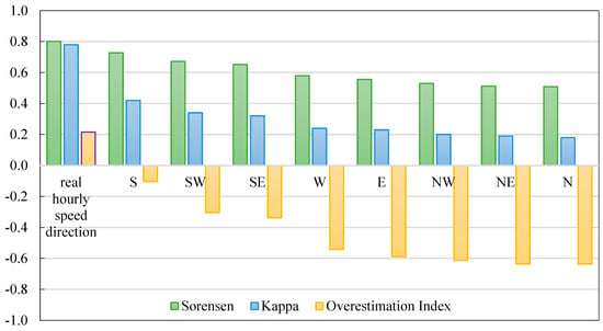
Figure A1.
Sorensen Number (SC), Kappa Number (), and Overestimation Index (OI) for reference hourly data of wind speed and wind direction in compaction with eight main wind directions.
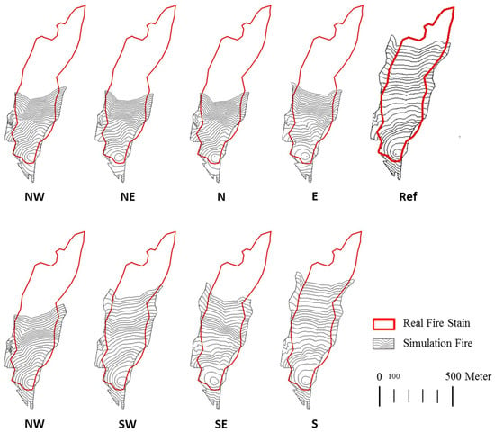
Figure A2.
The fire spread lines between specified time intervals in simulations for reference hourly data of wind speed and wind direction in compaction with eight main wind directions.
Appendix B. Scenarios
This study investigates the effects of changes in two climatic parameters, including air relative humidity and wind speed, on fire behavior during a fire in the Malekroud forest. Data from recent years in the region have been used to increase the accuracy of the results in relation to climatic parameters. Most of the fires in the Malekroud forest occur between October 26 and January 26. All hourly data extracted from the Iran Meteorological Organization for the quarterly fire peak period in the study area from 2003 to 2019 are considered and collected as separate files for analysis []. A specially formatted wind rose was prepared from the hourly data of wind speed and direction (see Figure A3). From this figure, we can conclude that the prevailing wind in this region is from a western direction and between 6.1 to 65.9 km/h.
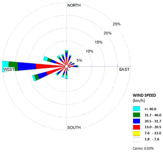
Figure A3.
Wind rose for the Malekroud forest (from 2003 to 2019 during 26 October to 26 January) [].
In the next step, the annual maximum, average, and minimum values for the quantities of temperature and air relative humidity were obtained. The total values of the average temperature and humidity collected from historical data collected in recent years during the period from 26 October to 26 January are 5 °C < T < 17 °C and 62% < h < 99%, respectively (see Figure A4 and Figure A5).
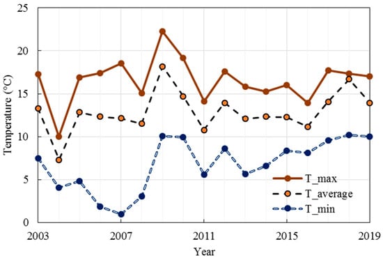
Figure A4.
Graph of annual maximum, average, and minimum temperature values in the Malekroud forest from 2003 to 2019 [].
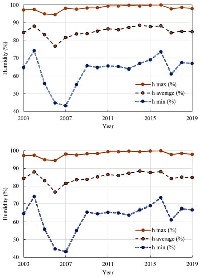
Figure A5.
Graph of annual maximum, average, and minimum air relative humidity values in Malekroud forest from 2003 to 2019 [].
The maximum and minimum ambient temperatures are necessary for simulating the effects of humidity changes in the FARSITE simulator. The temperature range for the desired period was between 5 °C and 17 °C; the same temperature range was used for all scenarios of humidity changes. The prevailing westerly wind direction was assumed to have an angle of 270 degrees to determine the simulation scenarios of wind speed changes. The numerical value of wind speed was selected according to the frequency of wind data in the study area.

Table A2.
Temperature and air relative humidity scenarios for simulation (minimum and maximum air temperature are, respectively, 5 °C and 17 °C).
Table A2.
Temperature and air relative humidity scenarios for simulation (minimum and maximum air temperature are, respectively, 5 °C and 17 °C).
| Item | Scenario | Objective Variable | Average Wind Speed (km/h) | Average Air Relative Humidity (%) |
|---|---|---|---|---|
| 1 | Ref. | - | 19.42 | 39 |
| 2 | Sc.01 | Air Relative Humidity | 19.42 | 2 |
| 3 | Sc.02 | Air Relative Humidity | 19.42 | 22 |
| 4 | Sc.03 | Air Relative Humidity | 19.42 | 42 |
| 5 | Sc.04 | Air Relative Humidity | 19.42 | 62 |
| 6 | Sc.05 | Air Relative Humidity | 19.42 | 72 |
| 7 | Sc.06 | Air Relative Humidity | 19.42 | 82 |
| 8 | Sc.07 | Air Relative Humidity | 19.42 | 92 |
| 9 | Sc.08 | Air Relative Humidity | 19.42 | 99 |
| 10 | Sc.09 | Wind Speed | 4.82 | 39 |
| 11 | Sc.10 | Wind Speed | 16.09 | 39 |
| 12 | Sc.11 | Wind Speed | 38.62 | 39 |
| 13 | Sc.12 | Wind Speed | 120.70 | 39 |
| 14 | Sc.13 | Wind Speed | 4.82 | 22 |
| 15 | Sc.14 | Wind Speed | 16.09 | 22 |
| 16 | Sc.15 | Wind Speed | 19.31 | 22 |
| 17 | Sc.16 | Wind Speed | 28.97 | 22 |
| 18 | Sc.17 | Wind Speed | 38.62 | 22 |
References
- Luo, Y.; Li, Q.; Jiang, L.; Zhou, Y. Analysis of Chinese Fire Statistics during the Period 1997–2017. Fire Saf. J. 2021, 125, 103400. [Google Scholar] [CrossRef]
- Doerr, S.H.; Santín, C. Global Trends in Wildfire and Its Impacts: Perceptions versus Realities in a Changing World. Philos. Trans. R. Soc. B Biol. Sci. 2016, 371, 20150345. [Google Scholar] [CrossRef]
- Kganyago, M.; Shikwambana, L. Assessing Spatio-Temporal Variability of Wildfires and Their Impact on Sub-Saharan Ecosystems and Air Quality Using Multisource Remotely Sensed Data and Trend Analysis. Sustainability 2019, 11, 6811. [Google Scholar] [CrossRef]
- Mamuji, A.A.; Rozdilsky, J.L. Wildfire as an Increasingly Common Natural Disaster Facing Canada: Understanding the 2016 Fort McMurray Wildfire. Nat. Hazards 2019, 98, 163–180. [Google Scholar] [CrossRef]
- Li, X.; Liu, L.; Qi, S. Forest Fire Hazard during 2000–2016 in Zhejiang Province of the Typical Subtropical Region, China. Nat. Hazards 2018, 94, 975–977. [Google Scholar] [CrossRef]
- Tomar, J.S.; Kranjčić, N.; Đurin, B.; Kanga, S.; Singh, S.K. Forest Fire Hazards Vulnerability and Risk Assessment in Sirmaur District Forest of Himachal Pradesh (India): A Geospatial Approach. ISPRS Int. J. Geo-Inf. 2021, 10, 447. [Google Scholar] [CrossRef]
- Ghorbanzadeh, O.; Blaschke, T.; Gholamnia, K.; Aryal, J. Forest Fire Susceptibility and Risk Mapping Using Social/Infrastructural Vulnerability and Environmental Variables. Fire 2019, 2, 50. [Google Scholar] [CrossRef]
- Liu, Y.; Stanturf, J.; Goodrick, S. Trends in Global Wildfire Potential in a Changing Climate. For. Ecol. Manag. 2010, 259, 685–697. [Google Scholar] [CrossRef]
- Eskandari, S.; Amiri, M.; Sãdhasivam, N.; Pourghasemi, H.R. Comparison of New Individual and Hybrid Machine Learning Algorithms for Modeling and Mapping Fire Hazard: A Supplementary Analysis of Fire Hazard in Different Counties of Golestan Province in Iran. Nat. Hazards 2020, 104, 305–327. [Google Scholar] [CrossRef]
- Zong, X.; Tian, X.; Yin, Y. Impacts of Climate Change on Wildfires in Central Asia. Forests 2020, 11, 802. [Google Scholar] [CrossRef]
- Kalabokidis, K.; Palaiologou, P.; Gerasopoulos, E.; Giannakopoulos, C.; Kostopoulou, E.; Zerefos, C. Effect of Climate Change Projections on Forest Fire Behavior and Values-at-Risk in Southwestern Greece. Forests 2015, 6, 2214–2240. [Google Scholar] [CrossRef]
- Eskandari, S.; Ghadikolaei, J.O.; Jalilvand, H.; Saradjian, M.R. Detection of Fire High-Risk Areas in Northern Forests of Iran Using Dong Model. World Appl. Sci. J. 2013, 27, 770–773. [Google Scholar]
- Ghobadi, G.J.; Gholizadeh, B.; Dashliburun, O.M. Forest Fire Risk Zone Mapping from Geographic Information System in Northern Forests of Iran (Case Study, Golestan Province). Int. J. Agric. Crop Sci. 2012, 4, 818–824. [Google Scholar]
- Beverly, J.L.; McLoughlin, N. Burn Probability Simulation and Subsequent Wildland Fire Activity in Alberta, Canada–Implications for Risk Assessment and Strategic Planning. For. Ecol. Manag. 2019, 451, 117490. [Google Scholar] [CrossRef]
- Argañaraz, J.P.; Gavier Pizarro, G.; Zak, M.; Bellis, L.M. Fire Regime, Climate, and Vegetation in the Sierras de Córdoba, Argentina. Fire Ecol. 2015, 11, 55–73. [Google Scholar] [CrossRef]
- Ghodrat, M.; Shakeriaski, F.; Nelson, D.J.; Simeoni, A. Existing Improvements in Simulation of Fire–Wind Interaction and Its Effects on Structures. Fire 2021, 4, 27. [Google Scholar] [CrossRef]
- Trucchia, A.; D’Andrea, M.; Baghino, F.; Fiorucci, P.; Ferraris, L.; Negro, D.; Gollini, A.; Severino, M. PROPAGATOR: An Operational Cellular-Automata Based Wildfire Simulator. Fire 2020, 3, 26. [Google Scholar] [CrossRef]
- Chew, Y.J.; Ooi, S.Y.; Pang, Y.H.; Wong, K.-S. A Review of Forest Fire Combating Efforts, Challenges and Future Directions in Peninsular Malaysia, Sabah, and Sarawak. Forests 2022, 13, 1405. [Google Scholar] [CrossRef]
- Zhou, T.; Ding, L.; Ji, J.; Yu, L.; Wang, Z. Combined Estimation of Fire Perimeters and Fuel Adjustment Factors in FARSITE for Forecasting Wildland Fire Propagation. Fire Saf. J. 2020, 116, 103167. [Google Scholar] [CrossRef]
- Cai, L.; He, H.S.; Wu, Z.; Lewis, B.L.; Liang, Y. Development of Standard Fuel Models in Boreal Forests of Northeast China through Calibration and Validation. PLoS ONE 2014, 9, e94043. [Google Scholar] [CrossRef]
- Koutsias, N.; Karteris, M. Classification Analyses of Vegetation for Delineating Forest Fire Fuel Complexes in a Mediterranean Test Site Using Satellite Remote Sensing and GIS. Int. J. Remote Sens. 2003, 24, 3093–3104. [Google Scholar] [CrossRef]
- Thompson, J.R.; Spies, T.A. Vegetation and Weather Explain Variation in Crown Damage within a Large Mixed-Severity Wildfire. For. Ecol. Manag. 2009, 258, 1684–1694. [Google Scholar] [CrossRef]
- Forthofer, J.M.; Butler, B.W.; McHugh, C.W.; Finney, M.A.; Bradshaw, L.S.; Stratton, R.D.; Shannon, K.S.; Wagenbrenner, N.S. A Comparison of Three Approaches for Simulating Fine-Scale Surface Winds in Support of Wildland Fire Management. Part II. An Exploratory Study of the Effect of Simulated Winds on Fire Growth Simulations. Int. J. Wildl. Fire 2014, 23, 982–994. [Google Scholar] [CrossRef]
- Forthofer, J.M.; Butler, B.W.; Wagenbrenner, N.S. A Comparison of Three Approaches for Simulating Fine-Scale Surface Winds in Support of Wildland Fire Management. Part I. Model Formulation and Comparison against Measurements. Int. J. Wildl. Fire 2014, 23, 969–981. [Google Scholar] [CrossRef]
- Finney, M.A. FARSITE, Fire Area Simulator—Model Development and Evaluation; US Department of Agriculture, Forest Service, Rocky Mountain Research Station: Fort Collins, CO, USA, 1998. [Google Scholar]
- Rothermel, R.C. A Mathematical Model for Predicting Fire Spread in Wildland Fuels; Intermountain Forest & Range Experiment Station, Forest Service: Ogden, UT, USA, 1972; Volume 115. [Google Scholar]
- Finney, M.A.; Andrews, P.L. FARSITE—A Program for Fire Growth Simulation. Fire Manag. Notes 1999, 59, 13–15. [Google Scholar]
- Boychuk, D.; Braun, W.J.; Kulperger, R.J.; Krougly, Z.L.; Stanford, D.A. A Stochastic Forest Fire Growth Model. Environ. Ecol. Stat. 2009, 16, 133–151. [Google Scholar] [CrossRef]
- Durrett, R. Stochastic Models of Growth and Competition. In Patch Dynamics; Springer: Berlin/Heidelberg, Germany, 1993; pp. 176–183. [Google Scholar]
- Knight, I.; Coleman, J. A Fire Perimeter Expansion Algorithm-Based on Huygens Wavelet Propagation. Int. J. Wildl. Fire 1993, 3, 73–84. [Google Scholar] [CrossRef]
- Finney, M.A.; Ryan, K.C. Use of the FARSITE Fire Growth Model for Fire Prediction in US National Parks. In Proceedings of the International Emergency Management and Engineering Conference, Nice, France, 9–12 May 1995; Sullivan, J.D., Wybo, J.L., Buisson, L., Eds.; Citeseer. International Emergency Management and Engineering Society: Paris, France, 1995; pp. 183–189. [Google Scholar]
- Arca, B.; Duce, P.; Laconi, M.; Pellizzaro, G.; Salis, M.; Spano, D. Evaluation of FARSITE Simulator in Mediterranean Maquis. Int. J. Wildl. Fire 2007, 16, 563–572. [Google Scholar] [CrossRef]
- Salis, M.; Arca, B.; Alcasena, F.; Arianoutsou, M.; Bacciu, V.; Duce, P.; Duguy, B.; Koutsias, N.; Mallinis, G.; Mitsopoulos, I. Predicting Wildfire Spread and Behaviour in Mediterranean Landscapes. Int. J. Wildl. Fire 2016, 25, 1015–1032. [Google Scholar] [CrossRef]
- Arca, B.; Duce, P.; Pellizzaro, G.; Laconi, M.; Salis, M.; Spano, D. Evaluation of FARSITE Simulator in Mediterranean Shrubland. For. Ecol. Manag. 2006, 234, S110. [Google Scholar] [CrossRef]
- Reinhardt, E.D.; Dickinson, M.B. First-Order Fire Effects Models for Land Management: Overview and Issues. Fire Ecol. 2010, 6, 131–142. [Google Scholar] [CrossRef]
- Zigner, K.; Carvalho, L.M.V.; Jones, C.; Benoit, J.; Duine, G.-J.; Roberts, D.; Fujioka, F.; Moritz, M.; Elmquist, N.; Hazard, R. Wildfire Risk in the Complex Terrain of the Santa Barbara Wildland–Urban Interface during Extreme Winds. Fire 2022, 5, 138. [Google Scholar] [CrossRef]
- Zigner, K.; Carvalho, L.M.V.; Peterson, S.; Fujioka, F.; Duine, G.-J.; Jones, C.; Roberts, D.; Moritz, M. Evaluating the Ability of FARSITE to Simulate Wildfires Influenced by Extreme, Downslope Winds in Santa Barbara, California. Fire 2020, 3, 29. [Google Scholar] [CrossRef]
- Clark, R.E.; Hope, A.S.; Tarantola, S.; Gatelli, D.; Dennison, P.E.; Moritz, M.A. Sensitivity Analysis of a Fire Spread Model in a Chaparral Landscape. Fire Ecol. 2008, 4, 1–13. [Google Scholar] [CrossRef]
- Friggens, M.M.; Loehman, R.A.; Constan, C.I.; Kneifel, R.R. Predicting Wildfire Impacts on the Prehistoric Archaeological Record of the Jemez Mountains, New Mexico, USA. Fire Ecol. 2021, 17, 18. [Google Scholar] [CrossRef]
- Adab, H.; Kanniah, K.D.; Solaimani, K. Modeling Forest Fire Risk in the Northeast of Iran Using Remote Sensing and GIS Techniques. Nat. Hazards 2013, 65, 1723–1743. [Google Scholar] [CrossRef]
- Shafiei, A.B.; Akbarinia, M.; Jalali, G.; Hosseini, M. Forest Fire Effects in Beech Dominated Mountain Forest of Iran. For. Ecol. Manag. 2010, 259, 2191–2196. [Google Scholar] [CrossRef]
- Jahdi, R.; Salis, M.; Darvishsefat, A.A.; Mostafavi, M.A.; Alcasena, F.; Etemad, V.; Lozano, O.; Spano, D. Calibration of FARSITE Simulator in Northern Iranian Forests. Nat. Hazards Earth Syst. Sci. 2015, 15, 443–459. [Google Scholar] [CrossRef]
- Jahdi, R.; Salis, M.; Alcasena, F.J.; Arabi, M.; Arca, B.; Duce, P. Evaluating Landscape-Scale Wildfire Exposure in Northwestern Iran. Nat. Hazards 2020, 101, 911–932. [Google Scholar] [CrossRef]
- Jaafari, A.; Rahmati, O.; Zenner, E.K.; Mafi-Gholami, D. Anthropogenic Activities Amplify Wildfire Occurrence in the Zagros Eco-Region of Western Iran. Nat. Hazards 2022, 114, 457–473. [Google Scholar] [CrossRef]
- Lan, Z.; Su, Z.; Guo, M.; Alvarado, E.C.; Guo, F.; Hu, H.; Wang, G. Are Climate Factors Driving the Contemporary Wildfire Occurrence in China? Forests 2021, 12, 392. [Google Scholar] [CrossRef]
- Jahdi, R.; Darvishsefat, A.A.; Etemad, V.; Mostafavi, M.A. Wind Effect on Wildfire and Simulation of Its Spread (Case Study: Siahkal Forest in Northern Iran). J. Agric. Sci. Technol. 2014, 16, 1109–1121. [Google Scholar]
- Ryu, S.-R.; Chen, J.; Zheng, D.; Lacroix, J.J. Relating Surface Fire Spread to Landscape Structure: An Application of FARSITE in a Managed Forest Landscape. Landsc. Urban Plan. 2007, 83, 275–283. [Google Scholar] [CrossRef]
- Li, X.; Zhao, G.; Yu, X.; Yu, Q. A Comparison of Forest Fire Indices for Predicting Fire Risk in Contrasting Climates in China. Nat. Hazards 2014, 70, 1339–1356. [Google Scholar] [CrossRef]
- Stratton, R.D. Assessing the Effectiveness of Landscape Fuel Treatments on Fire Growth and Behavior. J. For. 2004, 102, 32–40. [Google Scholar]
- Filippi, J.-B.; Mallet, V.; Nader, B. Representation and Evaluation of Wildfire Propagation Simulations. Int. J. Wildl. Fire 2013, 23, 46–57. [Google Scholar] [CrossRef]
- Filippi, J.-B.; Mallet, V.; Nader, B. Evaluation of Forest Fire Models on a Large Observation Database. Nat. Hazards Earth Syst. Sci. 2014, 14, 3077–3091. [Google Scholar] [CrossRef]
- Thompson, M.P.; Bowden, P.; Brough, A.; Scott, J.H.; Gilbertson-Day, J.; Taylor, A.; Anderson, J.; Haas, J.R. Application of Wildfire Risk Assessment Results to Wildfire Response Planning in the Southern Sierra Nevada, California, USA. Forests 2016, 7, 64. [Google Scholar] [CrossRef]
- Thompson, M.P.; Gannon, B.M.; Caggiano, M.D.; O’Connor, C.D.; Brough, A.; Gilbertson-Day, J.W.; Scott, J.H. Prototyping a Geospatial Atlas for Wildfire Planning and Management. Forests 2020, 11, 909. [Google Scholar] [CrossRef]
- CSR Group Group. Chesmandaz Scientific Research. Available online: https://gisland.org (accessed on 1 May 2021).
- INCC Iran National Cartographic Center. Available online: https://www.ncc.gov.ir/ (accessed on 8 May 2021).
- Arca, B.; Bacciu, V.; Duce, P.; Pellizzaro, G.; Salis, M.; Spano, D. Use of FARSITE Simulator to Produce Fire Probability Maps in a Mediterranean Area. In Proceedings of the 7th Symposyum on Fire and Forest Meteorology, Bar Harbor, ME, USA, 23–25 October 2007; pp. 23–26. [Google Scholar]
- Congalton, R.G. A Review of Assessing the Accuracy of Classifications of Remotely Sensed Data. Remote Sens. Environ. 1991, 37, 35–46. [Google Scholar] [CrossRef]
- Miller, C. Simulation of the Consequences of Different Fire Regimes to Support Wildland Fire Use Decisions. Fire Ecol. 2007, 3, 83–102. [Google Scholar] [CrossRef]
- Hammond, D.H.; Strand, E.K.; Hudak, A.T.; Newingham, B.A. Boreal Forest Vegetation and Fuel Conditions 12 Years after the 2004 Taylor Complex Fires in Alaska, USA. Fire Ecol. 2019, 15, 32. [Google Scholar] [CrossRef]
- Heisig, J.; Olson, E.; Pebesma, E. Predicting Wildfire Fuels and Hazard in a Central European Temperate Forest Using Active and Passive Remote Sensing. Fire 2022, 5, 29. [Google Scholar] [CrossRef]
- Li, X.; Zhang, M.; Zhang, S.; Liu, J.; Sun, S.; Hu, T.; Sun, L. Simulating Forest Fire Spread with Cellular Automation Driven by a LSTM Based Speed Model. Fire 2022, 5, 13. [Google Scholar] [CrossRef]
- Anderson, H.E. Aids to Determining Fuel Models for Estimating Fire Behavior [Grass, Shrub, Timber, and Slash, Photographic Examples, Danger Ratings]; USDA Forest Service general technical report; US Department of Agriculture, Forest Service, Intermountain Forest and Range Experiment Station: Fort Collins, CO, USA, 1982. [Google Scholar]
- Anderson, H.E. Aids to Determining Fuel Models for Estimating Fire Behavior; US Department of Agriculture, Forest Service, Intermountain Forest and Range: Ogden, UT, USA, 1981; Volume 122. [Google Scholar]
- Scott, J.H. Standard Fire Behavior Fuel Models: A Comprehensive Set for Use with Rothermel’s Surface Fire Spread Model; US Department of Agriculture, Forest Service, Rocky Mountain Research Station: Fort Collins, CO, USA, 2005. [Google Scholar]
- IRIMO Iran Meteorological Organization. Available online: https://www.irimo.ir (accessed on 1 July 2020).
- Rothermel, R.C. How to Predict the Spread and Intensity of Forest and Range Fires; US Department of Agriculture, Forest Service, Intermountain Forest and Range: Ogden, UT, USA, 1983; Volume 143. [Google Scholar]
- WUW Website Weather Underground’s WunderMap. Available online: https://www.wunderground.com/ (accessed on 7 November 2021).
Disclaimer/Publisher’s Note: The statements, opinions and data contained in all publications are solely those of the individual author(s) and contributor(s) and not of MDPI and/or the editor(s). MDPI and/or the editor(s) disclaim responsibility for any injury to people or property resulting from any ideas, methods, instructions or products referred to in the content. |
© 2023 by the authors. Licensee MDPI, Basel, Switzerland. This article is an open access article distributed under the terms and conditions of the Creative Commons Attribution (CC BY) license (https://creativecommons.org/licenses/by/4.0/).