1. Introduction
Several climate studies now reveal a worrying trend, especially in Portugal and other southern European countries, regarding the occurrence of extreme natural events. Research carried out as part of a broader study by the European Forestry Institute on forest fires predicts that temperature levels (especially in summer) in Portugal will be higher and precipitation levels lower than average [
1]. The rise in temperatures and the decrease in humidity are well-established trends, showing no signs of abating soon and appearing to be key drivers of major fires in the coming years [
2].
In Portugal, many isolated housing clusters are difficult to access and predominantly inhabited by the elderly or people with disabilities and are in regions with a high risk of wildfire. The problem of rural abandonment is widely recognized, especially in the northern and central parts of the country, with villages becoming increasingly isolated and populations aging, and where the forest increasingly enters the villages, as the residents no longer have the capacity to practice agriculture or clear fuel around the villages due to their advanced age [
3].
The aforementioned factors, combined with the sociodemographic changes experienced in Portugal, result in an increasing number of inhabitants being exposed to the danger of rural fires [
4]. An analysis of the victims of wildfires in Portugal in 2017, focusing on their behavior when the fires approached, revealed that 25% of the victims died inside their homes, having been caught by the fires, without receiving an alert or evacuation order [
5]. In this way, it becomes imperative to know the locations and those with limitations in perception and reaction, so that authorities can, in advance, evacuate these people from dangerous zones, as they may not be able to do so on their own.
2. The Role of Parish Councils in Georeferencing
Emergency management primarily involves handling the period between the emergency and the arrival of structured assistance, to safeguard the safety of people and property in the affected area, thereby limiting the negative consequences of the event [
6].
Parishes are local authorities in Portugal that, within the municipal territory, aim to serve the interests of the population residing in each parish area [
7]. There are currently 3091 parishes: 2882 parishes in mainland Portugal, 155 in the Autonomous Region of the Azores and 54 in the Autonomous Region of Madeira. Parish councils are crucial in the processes of governance and public management. These governance structures are the entities closest to the population, allowing them to more easily identify the problems faced by the most vulnerable individuals. They can also contribute to maintaining an updated database, which can be used in emergencies to support decision-making regarding necessary actions.
3. Approach
Considering the awareness raised above, a methodology was developed involving parish councils, where individuals working within this structure could actively contribute to maintaining an updated database of the most vulnerable people and those with special needs who require special attention during natural disasters.
3.1. Steps
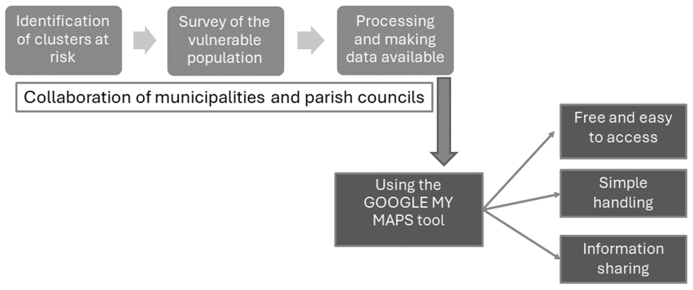
The identification and analysis of population vulnerabilities are fundamental in the current scenario of climate change, both for preventing and preparing for disasters and for facilitating relief during emergencies. To facilitate the inventory process of the most vulnerable population and those with special needs, three essential steps were established:
- -
Identification of clusters at risk: In this step, local authorities identify the highest priority villages to focus on, based on the type of population, the village’s surroundings, and its accessibility.
- -
Survey of the vulnerable population: Visits are carried out to the villages, with purposes such as monitoring the local inhabitants, finding where the inhabited houses are and surveying to identify the type of inhabitants and recording of any special need that must be taken into account in case of an emergency.
- -
Processing and making data available: All collected information is entered into Google’s My Maps, with only data relevant to emergency planning being recorded.
The simple step-by-step application scheme allows us to identify some implementation advantages that allow for greater acceptance by those involved (
Figure 1).
After identifying the villages at greatest risk, an on-the-ground survey of people with physical and mental limitations is carried out, and these are recorded on a grid but also marked in the Google My Maps tool. This tool provides easy and free access, requiring only internet access and a smartphone for the operator. The application only records the location of the person with limitations, their housing conditions, and any special needs, without adding any personal information or sensitive data. Once the database is established, authorized users can add or update information at any time. All this information can be printed off or consulted offline on a mobile phone without the need to install any software or use complex GIS tools.
3.2. Test Group
After organizing the steps, this procedure was tested in four parishes in the center of Portugal, in the municipalities of Lousã, Miranda do Corvo and Anadia. Meetings were held with parish council representatives to discuss the added value and challenges of the procedure. The aim is to use this system for a year to evaluate its advantages.
Following the surveys, in which the local population was involved, council staff updated the database whenever there were changes in occupation, e.g., death of a resident or new inhabitants. As the population felt involved and was satisfied with these procedures, the village inhabitants themselves began alerting the council to changes in occupation, becoming important players in the entire process. The information remains constantly updated in platform (
Figure 2), and in two cases, it has been tested through a simulation exercise.
In this exercise, it was observed that information was easily shared with operational decision-makers, facilitating decision-making and resource planning. When a large fire approaches, the command post provides real-time information, which can be integrated into decision support systems, thus being used in decisions such as the need to evacuate a village.
After a year of use, those responsible for the parish councils were interviewed and were invited to present the advantages and limitations of the procedure. The parish councils identified the following advantages:
The ease of use of the application motivated them to use it in other villages.
Georeferencing the most vulnerable people and those with special needs becomes important, not only for forest fire situations but also for other relief needs.
The ease of sharing this information allowed, for example, the improvement of patrolling actions by security forces.
The main constraints were identified:
There are mobile network difficulties in some areas of the interior of Portugal—in some situations, data insertion and updating could not be carried out in the village itself. This same difficulty could compromise the sending of information to the command post in a real fire situation.
In larger parishes, to keep the database up to date, it was suggested that each village have a liaison officer.
4. Conclusions
Portugal faces a problem with its population, especially in the interior regions. Many villages are scattered in areas of high fire risk, and mostly inhabited by elderly people or those with physical and cognitive limitations. Therefore, it is important that the rescue services know exactly where these people are and the conditions in which they can be found.
One of the biggest challenges is keeping this information updated over time. By using and valuing the proximity of parish councils, it is possible to maintain an updated database, using simple and free tools. These tools allow information sharing and support civil protection services, which often lack the means and resources to keep this information updated.
Parish councils, as the government structure closest to the people, play a fundamental role in maintaining a population database, using simple georeferenced systems. The use of complex georeferencing tools has distanced local authorities from the inventory process, and this process presents an attempt to solve this problem, creating a simple system that only requires a smartphone and little specific training.
With the dissemination of this procedure, it is hoped to gradually achieve an inventory of the territories most exposed to extreme dangers, so that their safety is ensured before and during a possible damaging event.
Author Contributions
Conceptualization, A.R. and D.X.V.; methodology, A.R.; software, A.R.; validation, A.S., D.X.V. and J.L.Z.; writing—original draft preparation, A.R.; writing—review and editing, A.R.; visualization, D.X.V. and J.L.Z.; supervision, A.S.; project administration, A.S.; funding acquisition, A.S. All authors have read and agreed to the published version of the manuscript.
Funding
This work is financed by national funds through FCT—Foundation for Science and Technology under grant agreement 2023. 02015.BD attributed to the 1st author and project “EVACUARFLORESTA—decisions and evacuation plans in forest fire scenarios”, grant number PCIF/AGT/0061/2019.
Institutional Review Board Statement
Not applicable.
Informed Consent Statement
Not applicable.
Data Availability Statement
Data sharing is not applicable to this abstract.
Conflicts of Interest
The authors declare no conflicts of interest.
References
- Moreira, F.; Catry, F.X.; Rego, F.; Bacao, F. Size-dependent pattern of wildfire ignitions in Portugal: When do ignitions turn into big fires? Landsc. Ecol. 2010, 25, 1405–1417. [Google Scholar] [CrossRef]
- Beighley, M.; Hyde, A.C. Gestão dos Incêndios Florestais em Portugal numa Nova Era Avaliação dos Riscos de Incêndio, Recursos e Reformas; Center for Forestry Studies—Higher Institute of Agronomy of the University of Lisbon: Lisbon, Portugal, 2018. [Google Scholar]
- Manzello, S.L.; Blanchi, R.; Gollner, M.J.; Gorham, D.; McAllister, S.; Pastor, E.; Planas, E.; Reszka, P.; Suzuki, S. Summary of workshop large outdoor fires and the built environment. Fire Saf. J. 2018, 100, 76–92. [Google Scholar] [CrossRef] [PubMed]
- Molina-Terrén, D.M.; Xanthopoulos, G.; Diakakis, M.; Ribeiro, L.; Caballero, D.; Delogu, G.M.; Viegas, D.X.; Silva, C.A.; Cardil, A. Analysis of forest fire fatalities in Southern Europe: Spain, Portugal, Greece and Sardinia (Italy). Int. J. Wildland Fire 2019, 28, 85–98. [Google Scholar] [CrossRef]
- Rodrigues, A.; Santiago, A.; Laím, L.; Viegas, D.X.; Zêzere, J.L. Rural Fires—Causes of Human Losses in the 2017 Fires in Portugal. Appl. Sci. 2022, 12, 12561. [Google Scholar] [CrossRef]
- Alexander, D.; David, E. Principles of Emergency Planning and Management; Oxford University Press: Oxford, UK, 2002. [Google Scholar]
- Freitas do Amaral, D. Administrative Law Course—Volume I; Livraria Almedina: Lisbon, Portugal, 1986. [Google Scholar]
| Disclaimer/Publisher’s Note: The statements, opinions and data contained in all publications are solely those of the individual author(s) and contributor(s) and not of MDPI and/or the editor(s). MDPI and/or the editor(s) disclaim responsibility for any injury to people or property resulting from any ideas, methods, instructions or products referred to in the content. |
© 2025 by the authors. Licensee MDPI, Basel, Switzerland. This article is an open access article distributed under the terms and conditions of the Creative Commons Attribution (CC BY) license (https://creativecommons.org/licenses/by/4.0/).


