Abstract
The research focuses on analyzing historical climate variability over the period 1982–2022, as well as future projections of climate change over the period 2025–2099, with regard to the Souss-Massa watershed, a semi-arid region with high dependency on agricultural activities. Precipitation and temperature data were collected annually from five meteorological stations, Agadir, Amaghouz, Amsoul, Aoulouz, and Taroudant, in order to analyze long-term climatic trends and predict possible scenarios of climate change. A trend analysis was carried out using a combination of the Mann–Kendall test and Sen’s slope estimator. The findings of this study indicate that there is an increase in mean annual temperature that is statistically significant (p < 0.05) across all stations, ranging from +0.28 °C per decade at Agadir, which is located along the coastal region of Morocco, to as high as +0.45 °C per decade at Taroudant, which is located inland. Conversely, the precipitation trend is decreasing and not statistically significant (p > 0.05). For projecting future climatic conditions, we used the Statistical Down-Scaling Model (SDSM v4.2.9) with global climate models using outputs from CanESM2 under two emission scenarios, namely RCP 4.5 and RCP8.5. The calibration period (1982–2001) and the validation period (2002–2022) were satisfactory, as indicated by the high values of the coefficients of determination (R2 > 0.6) for temperature and moderate values (R2 = 0.5–0.6) for precipitation. Projections indicate an increase in temperature, with the mean temperature change ranging from +4.8 °C and +8.7 °C by 2099 depending on the station’s location. Projected precipitation decreases are found under both scenarios, but with stronger decreases under RCP8.5, especially along the coastal regions, with decreases as large as −53.8% at Agadir. However, the precipitation projections have to be used with caution due to the limitations associated with the downscaling methods and the use of a single global climate model. All the projections indicate a trend towards arid conditions, emphasizing the need for adaptive water resources management and improving the ensemble models for climate projections.
1. Introduction
Climate change is one of the greatest challenges of the 21st century, defined as a long-term change in weather patterns that do not occur locally but globally. Our understanding of extreme climate events has improved considerably in the last several decades, as much research has been carried out [1]. The evidence shows dramatic changes in the frequency and intensity of climate extremes across continents, regions, and ocean basins [2]. Various regions are already seeing shifts in climate that modify patterns of precipitation and temperature. Continued environmental changes will increase modifications to hydrological processes in many regions, particularly in arid and semi-arid regions [3]. It is anticipated that these impacts will worsen as global warming continues. The research highlights how climate change is altering rainfall patterns, resulting in more severe droughts and floods in several regions. Precipitation is predicted to decrease in most subtropical zones and to increase at high latitudes [4].
The Mediterranean basin is now recognized as a primary “climate hot spot,” with warming rates projected to exceed the global average by 20–50% [5,6,7]. Simulations carried out through regional climate models have shown that a projected decrease in annual precipitation by 10–30% by the end of the 21st century, especially during the wet season; there is also a predicted increase in the frequency and intensity of extreme climate events such as droughts, heatwaves, and flash floods [8,9,10].
In North Africa, the effects of climate change are expected to be more significant, especially considering the already-arid conditions, significant interannual climate variability, and high socio-economic dependence on climate-sensitive sectors such as agriculture and water resources [11,12]. Regional projections suggest a warming of 2–4 °C and a precipitation decline of 10–20% under moderate scenarios, with even more severe warming expected under high-emission pathways [13,14,15].
Moreover, the IPCC hopes that there will be an annual decrease in precipitation for much of Mediterranean Africa and the northern Sahara, estimating that the chances of reduced precipitation increase the closer one gets to the Mediterranean coast [16]. Global sea levels may increase by as much as 48 cm by 2099, according to the IPCC reference scenario, while temperatures in the western Mediterranean Basin could rise by an average of 2.8 °C, accompanied by a decrease in precipitation of approximately 12% [17]. Thus, climate change poses a significant challenge for North Africa, profoundly impacting both environmental and human systems [11]. This area has a very diverse climate with significant temporal fluctuation, especially in precipitation [18]. North African coastal areas, including Morocco, are at risk from climate change stemming from intensive development driven by agriculture [19,20,21].
Despite being positioned on the Atlantic and Mediterranean Coast, Morocco remains part of an arid region, characterized by variable rainfall and unpredictable drought periods. The stress on the already limited water resources is increased by competing demand and quick deterioration [16]. Various studies on precipitation in Morocco have revealed that years of precipitation deficit are more frequent than years of excess. The general trend shows a decrease in precipitation [14,22,23,24,25].
Recent studies in Morocco have reaffirmed these trends, showing that the warming trend over the period from 1960 to 2005 was in the range of 1.0 to 1.8 °C. There has also been a general decrease in precipitation over the years, ranging from 3 to 30% in different regions [26,27]. For example, in the High Atlas Mountains, where there is an important source of downstream water resources, the decrease in snowpack and the earlier onset of spring snowmelt have further stressed the available water during the dry season. There have also been more extreme temperature events, such as an increase in the frequency of warm nights and heatwave days [28,29]. Drought frequency and severity have increased in the southern and semi-arid regions of the country [30].
The Souss-Massa watershed is used as an example to illustrate the associated vulnerabilities in semi-arid environments facing the effects of climate change. This region is considered one of the most important agricultural areas in Morocco, and the increasing pressure on water resources is the result of growing demand and climatic variability. Previous studies in the Souss-Massa watershed in the Souss-Massa River Basin emphasized the sensitivity of the region to water stress resulting from groundwater over-exploitation and increased irrigation demands in the context of climate variability [31,32]. However, a comprehensive study combining historical trend analysis with future projections using statistical downscaling is lacking.
While the historical precipitation trend shown in many Moroccan research works is ambiguous and non-significant, the present study presents a rigorous statistical analysis using the Mann–Kendall and Sen’s slope tests to confirm whether the trend in the Souss-Massa watershed is statistically significant or merely reflects natural variability.
Although there is an increasing body of literature on climate change research in Morocco, no study has been found to date that has employed and validated the Statistical Downscaling Model (SDSM) with the CanESM2 model in the Souss-Massa watershed, a region with considerable economic and agricultural significance. Furthermore, this research provides the first comprehensive assessment that incorporates a robust statistical detection of trends (Mann–Kendall and Sen’s slope) with future projections based on two contrasting emission pathways (RCP 4.5 and RCP8.5) at five locations with strategic significance in the Souss-Massa watershed. This is a critical gap in our current understanding of past trends and future risks in this highly susceptible semi-arid environment.
This study pursues four main objectives. Firstly, the paper aims to identify and quantify any statistically significant historical precipitation and temperature trends from 1982 to 2022 using the Mann–Kendall test and Sen’s slope method. Guided by regional previous studies, we predict that there will be a statistically significant historical warming trend at all stations (H1), while the historical precipitation decline will not be statistically significant due to the high year-to-year variability (H2). The second objective is to calibrate and validate the Statistical Downscaling Model (SDSM) for downscaling large-scale climate variables in the Souss-Massa context. The third objective is to project future climate change (2025–2099) under RCP 4.5 and RCP8.5 scenarios using the validated SDSM with CanESM2 predictors. We hypothesize that future projections under both scenarios will show continued warming throughout the 21st century (H3), and that the magnitude of both warming and precipitation decline will be significantly greater under the high-emission RCP8.5 scenario compared to the moderate RCP 4.5 scenario (H4). The fourth objective is to discuss the implications of these projections for water resources and agriculture in the context of uncertainty, and to provide evidence-based recommendations for adaptation planning.
2. Materials and Methods
2.1. Study Area
Located in central–western Morocco, the Souss-Massa watershed (Figure 1) is more than 27,000 km2 and contains varied topography. It consists of 21% plains (~5700 km2), and 79% mountains (21,300 km2). The watershed’s altitude is also varied, ranging from sea level at the Atlantic coastline to 4167 m at Toubkal, which is the highest peak in the High Atlas. Its main plains, the Souss and Chtouka-Massa plains, range between 0 and 700 m elevation above sea level. The local economy is largely dependent on these plains for agriculture, which shows strong dependence on the water available through the watershed. Its climate is mainly semi-arid to desert, except for the pre-Saharan regions and the western-high Atlas Mountains, which can be humid with cold winters. Closeness to the Atlantic Ocean, the cooling effect of the Canary Current, and the Anti-Atlas barrier offer some moderation of these conditions through protection from southern winds [33].
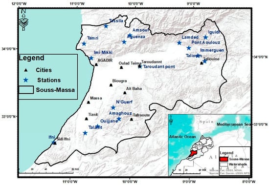
Figure 1.
Geographic location of the Souss-Massa watershed.
Rainfall differs a lot temporally and spatially, but it is significantly reduced in the plains compared to the mountains. Between 1998 and 2015, the plains received 250 mm to 300 mm of average annual rain compared to 500 mm to 600 mm of annual rain for the mountains. The dry season lasted from May to October in 1980–2013. Most annual precipitation occurred during the months from November to March [34]. Anti-Atlas and High Atlas average yearly temperatures range from 14 °C to 20 °C, while the plains can be as hot as 48 °C. In addition to the varying temperatures throughout the year, there can be significant daily temperature fluctuations between winter temperatures of 19 °C and summer temperatures of 27 °C [35].
In the hilly zones and the Atlantic Coast, annual evaporation rates are 1400 mm; evaporation rates in the Souss, Massa, and Tiznit plains increase to 2000 mm [36]. Evaporation rates are very low in January, but maximal in July, and average about 100 mm (270 mm) in the plains and 35 mm (240 mm) in the mountains [33].
2.2. Methodology
2.2.1. Data Sources
Historical daily precipitation and temperature records (maximum, minimum, and mean) from 1982 to 2022 were collected from five meteorological stations (Table 1) via the Souss-Massa Hydraulic Basin Agency (ABHSM, Agadir, Morocco)) and the Moroccan Directorate General of Meteorology (DGM, Casablanca, Morocco). The five stations were selected based on the completeness and quality of the available time-series data, thereby ensuring that the stations are sufficiently apt for robust trend analysis. The large-scale atmospheric predictor fields used in the model calibration, as well as the results from the CanESM2 global climate model (Canadian Centre for Climate Modelling and Analysis, Victoria, BC, Canada; version of the model used in CMIP5), were obtained from the Canadian Climate Data and Scenarios website (https://climate-scenarios.canada.ca/, accessed on 4 March 2026). The NCEP/NCAR reanalysis predictors (National Centers for Environmental Prediction/National Center for Atmospheric Research, Boulder, CO, USA; https://psl.noaa.gov/data/reanalysis/, accessed on 4 March 2026) were also used for model calibration. The results include the historical scenario as well as the results from future periods corresponding to the RCP 4.5 and RCP8.5 scenarios. The selection of the CanESM2 model was primarily based on the availability of the requisite predictor variables needed in the SDSM, as well as its previous usage in regional studies, thereby ensuring a degree of comparability. This, however, is the primary limitation of the current research.

Table 1.
Geographical coordinates of meteorological stations in Souss-Massa.
2.2.2. Historical Trend Analysis
For the detection and quantification of past trends, the non-parametric Mann–Kendall test was applied to the time series of total annual precipitation and mean temperature at each station. The Mann–Kendall test identifies monotonic trends without assuming any specific data distribution. The magnitude of the trend was calculated using Sen’s slope estimator. Statistical significance was tested at α = 0.05 [37,38,39]. These statistical analyses were performed using R software (version 4.3.2, R Foundation for Statistical Computing, Vienna, Austria; https://www.r-project.org/) with the “trend” package (version 1.1.6). Results are presented as anomalies relative to the 1982–2022 multi-annual mean where appropriate.
2.2.3. Future Climate Modeling with SDSM
The Statistical Downscaling Model (SDSM, version 4.2.9), developed by Wilby et al. [40] (Loughborough University, Loughborough, UK; https://sdsm.org.uk/) was employed to generate future climate projections. The procedure involved the following steps:
1. Quality Control and Data Preparation: Observed historical data were examined for missing values, outliers, and homogeneity. Daily precipitation and temperature data were formatted for SDSM.
2. Selection of Predictor: The selected atmospheric predictor variables from the NCEP/NCAR data set were subjected to correlation analysis for the selection of the most appropriate local variable predictor.
3. Model Calibration (1982–2001): Multiple linear regression equations were used to establish the link between local predictands and the selected local predictor variables from the data set. The parameters of the models were determined using the default algorithms of the SDSM software.
4. Weather Generation: The calibrated model was used to create artificial daily weather time series data for the calibration period, with the objective of evaluating the model’s performance.
5. Model Validation (2002–2022): The synthetic data was validated using observed data, with metrics such as R2, Root Mean Square Error (RMSE), Nash–Sutcliffe Efficiency (NSE), and Mean Bias.
6. Scenario Generation: The validated model was employed using CanESM2 predictors under RCP 4.5 and RCP8.5 scenarios to produce synthetic daily climate time series for 2025–2099. Ensemble members (20) were produced to represent stochastic uncertainty.
However, the study acknowledges the uncertainty associated with statistical downscaling, as well as the limitation imposed by the application of a single global climate model (CanESM2), which determines the entire scope of the variability associated with climate projections. There are other uncertainties associated with internal climate variability and the assumptions used in the statistical downscaling methods.
3. Results and Discussion
3.1. Historical Climate Trends (1982–2022)
3.1.1. Precipitation Trends
Annual precipitation variability during the period 1982–2022 was analyzed at five meteorological stations in the Souss-Massa watershed. In the time-series analysis, a marked alternation between wet and dry periods is observed, reflecting the strong interannual variability characteristic of semi-arid climates, with five major periods of high variability: 1982–1986, 1987–1989, 1990–2008, 2009–2011, and 2012–2022 (Figure 2). While the periods from 1987 to 1989 and from 2009 to 2011 showed precipitation levels much higher than the mean, the other periods show arid conditions, except for the years 1982, 1996, and 2014, during which precipitation reached critically low levels.
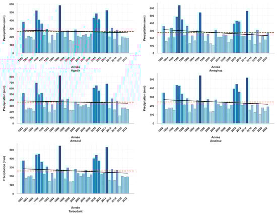
Figure 2.
Evolution of annual precipitation from 1982 to 2022 at five stations in the Souss-Massa watershed. The colored bars represent annual precipitation totals, with darker shades indicating wetter years (higher precipitation) and lighter shades indicating drier years (lower precipitation). The solid black line represents the 5-year moving average, and the dashed red line shows the linear trend.
The box plot for the interannual variability in precipitation provides an alternative perspective on the interannual variability in precipitation. The median precipitation varies from 244 mm at Aoulouz to 365 mm at the high-elevation station Amsoul, which enjoys orographic enhancement. The interquartile range (IQR) is large at all stations, ranging from 150 to 200 mm. This indicates the large variability that is characteristic of semi-arid climates. The distribution is highly skewed, with many values extending beyond the whiskers, which correspond to extreme wet years such as 1995/1996 and strong drought years such as 2018/2019, which were identified in the time series.
At the local scale, the Agadir station shows a considerable gap between the hydrological year 1995/1996, which was the wettest on record, with 584.3 mm, and the 2018/2019 period, during which a notable rainfall deficit of 94.4 mm was recorded. Similarly, the observed data from Amaghouss Station exhibit a similar variability pattern. The highest amount of rainfall in the year 1987/1988 was recorded to be 637.3 mm, and then it decreased sharply in the year 2000/2001 to reach a minimum of 100.6 mm. Observations recorded at Amsoul, as well as Aoulouz, also emphasize this irregularity, with the wet season of 1995/1996 recording 819.4 mm and 542.8 mm, respectively, compared with the extremely dry season of 2018/2019, during which the rainfall never exceeded 133.2 mm and 100.08 mm. Data from the station at Taroudant confirm this pattern, with rainfall varying between a maximum of 544.9 mm in 1995/1996 and a minimum of 89.02 mm in 2018/2019.
The MK test results show a general trend of decreasing precipitation amounts on an annual basis for all stations (Agadir, Amaghouss, Amsoul, Aoulouz, and Taroudant). However, the statistical significance of these trends differs in space.
For the Agadir and Amaghouss stations, there were negative trends, with Sen’s slopes of −0.91 mm/year and −1.85 mm/year, respectively. Nevertheless, these trends were not statistically significant (p > 0.05). Amsoul also showed a negative trend of −3.42 mm/year, which was again statistically insignificant at the 95% confidence level.
The low coefficients of determination (R2 ranging from 0.006 to 0.035) further confirm the absence of a strong linear trend and the dominance of interannual variability in the precipitation record, a finding that is visually supported by the wide dispersion and numerous outliers observed in the box plots.
Conversely, Aoulouz and Taroudant stations showed more pronounced negative trends of −2.74 mm/year and −2.96 mm/year, respectively. These trends were marginally significant (p = 0.058) at Aoulouz and weakly significant (p = 0.081) at Taroudant, suggesting a progressive intensification of aridity in the interior regions of the watershed (Table 2).
Table 2.
Mann–Kendall trend analysis and Sen’s slope estimates for annual precipitation and mean temperature (1982–2022).
3.1.2. Temperature Trends
In contrast to precipitation, a trend analysis of maximum (T-max), minimum (T-min), and mean (T-mean) annual temperatures reveals a clear and consistent upward trend at all monitoring stations (Figure 3). The temporal evolution of temperature can be divided into four main periods: 1982–1990, 1991–2001, 2002–2016, and 2017–2022. Relatively stable temperature conditions are observed from 1982 to 1990 and 2002 to 2016, while increasing trends are evident from 1991 to 2001 and 2017 to 2022.
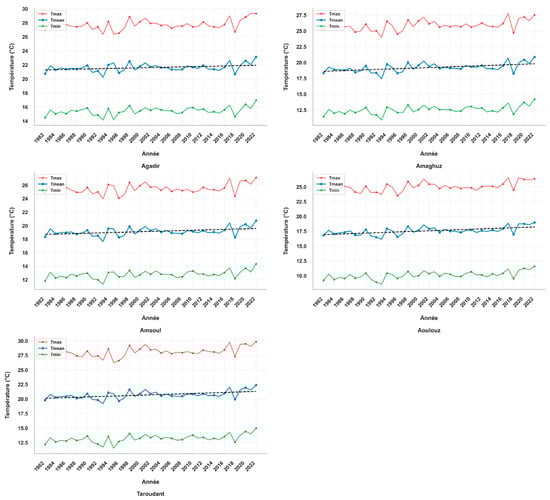
Figure 3.
Evolution of annual maximum, minimum, and average temperatures from 1982 to 2022 at five stations in the Souss-Massa watershed.
The box plot of annual mean temperatures (Figure 4) provides a synthetic view of the thermal regime across the watershed, clearly illustrating the spatial gradient from coast to interior. The coastal station of Agadir, the mean maximum temperature, T-max, was 27 °C, while the mean minimum temperature, T-min, was 15 °C, and the mean temperature, T-mean, of 21 °C. Similarly, at Amaghouss and Amsoul, temperatures of 25 °C, 12 °C, and 18 °C, respectively, were recorded for T_max, T_min, and T_mean. The results indicate that all three thermodynamic parameters recorded at these three locations showed an increase of 1 °C when comparing the periods between 1991 and 2001 and 2017 and 2022. The increase was more pronounced at inland locations, namely Aoulouz and Taroudant, where temperatures showed an increase of 2 °C. The range of maximum temperatures recorded across these regions was found to vary between 24 °C and 27 °C, with minimum temperatures recorded as between 9 °C and 15 °C, resulting in mean temperatures varying between 17 °C and 21 °C.
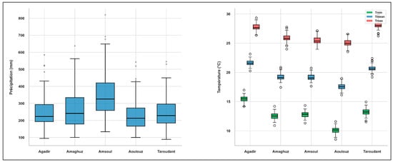
Figure 4.
Box plot distribution of annual precipitation and temperature variables (T-min, T-mean, and T-max) across the Souss-Massa meteorological stations (1982–2022).
The statistical significance of the temperature increase can be further supported by the outcome of the Mann–Kendall test, as indicated in Table 2. The Agadir region shows a significant warming trend, with a Sen’s slope of +0.028 °C per year (+0.28 °C per decade, p < 0.01), consistent with the positive trend observed in the time series, with a statistical significance of p < 0.01. Similarly, significant trends are found in the temperature series of Amaghouss and Amsoul, with annual rates of +0.032 °C and +0.034 °C, respectively. The highest rates of temperature increase are found in the interior regions of Aoulouz and Taroudant, with annual rates of +0.041 °C and +0.045 °C, respectively, and with a statistical significance of p < 0.001, corresponding to decadal temperature increase rates of +0.41 °C and +0.45 °C.
The results of the box plot analysis confirm these observations, with the interior stations (Aoulouz, Taroudant) showing higher dispersion and higher medians in temperature values compared to the coastal and mountainous stations, in agreement with the higher values of the Sen’s slope.
Moreover, the spatial distribution shows an incremental increase in temperature from the coast to the interior, reflecting increasing continental influence from coastal to inland areas and the high sensitivity of the region to climate change. In addition, this increase in temperature, coupled with the concurrent decline in precipitation, represents a significant challenge for water resource sustainability in the Souss-Massa region as the dry periods of 2000–2001 and 2018–2019 experienced an increase in temperature.
3.2. SDSM Calibration and Validation
The performance metric for the model over the validation period from 2002 to 2022 is presented in Table 3. The model demonstrates a strong ability to reproduce observed climate variability, with specific proficiency in temperature. For temperature, the values of R2 range from 0.77 to 0.84, while the values of Nash–Sutcliffe Efficiency (NSE) range from 0.75 to 0.82. Biases are very small (≤0.2 °C). For precipitation, the model performance is moderate, with R2 values ranging from 0.52 to 0.62, and NSE values ranging from 0.50 to 0.60. This behavior is expected due to the inherently stochastic nature of precipitation and higher variability of precipitation, and it is considered acceptable for statistical downscaling in semi-arid regions. Similar performance differences between temperature and precipitation simulations have been reported in previous statistical downscaling studies.
Table 3.
SDSM performance metrics during validation (2002–2022).
3.3. Future Climate Projection
An analysis of the results from different models, such as the CMIP5 model, as discussed and presented in the Intergovernmental Panel on Climate Change’s Fifth Assessment Report (IPCC), is vital for understanding the variations that occur in temperature and precipitation within the region of interest.
After completing several processes, including weather generation, model calibration, data analysis, and scenario generation, synthetic daily weather datasets were generated by modifying the Statistical Downscaling variables for the RCP 4.5 and RCP8.5 scenarios. These variables were normalized to the reference period (1982–2022) to ensure consistent projections and enable reliable monitoring of future climatic changes. For this study, we chose two scenarios, RCP8.5, the high-emission scenario characterized by stronger radiative forcing and more pronounced climate change impacts, and RCP 4.5, the moderate-emission scenario with measures to regulate global warming [41].
3.3.1. Precipitation
Projected mean annual precipitation from 2025 to 2099 relative to the baseline period is shown in Table 4. The results show a general decrease in precipitation at all stations under the two scenarios. However, the magnitude of this reduction varies considerably by station and scenario.
Table 4.
Projected mean annual precipitation (mm and % change) for 2025–2099 relative to the 1982–2022 baseline.
Analysis of the expected precipitation for the Souss-Massa region for the year 2099 (Figure 5) shows large differences between the two scenarios. For the RCP 4.5 scenario, which is relatively optimistic, there is a trend of decreasing precipitation. The average precipitation per year will be 379.44 mm in Agadir 203.68 mm in Amaghouz, 254.9 mm in Amsoul 211.7 mm in Aoulouz and 145.19 mm in Taroudant. This represents a decrease of between −10.8% and −17.1% from the reference period.
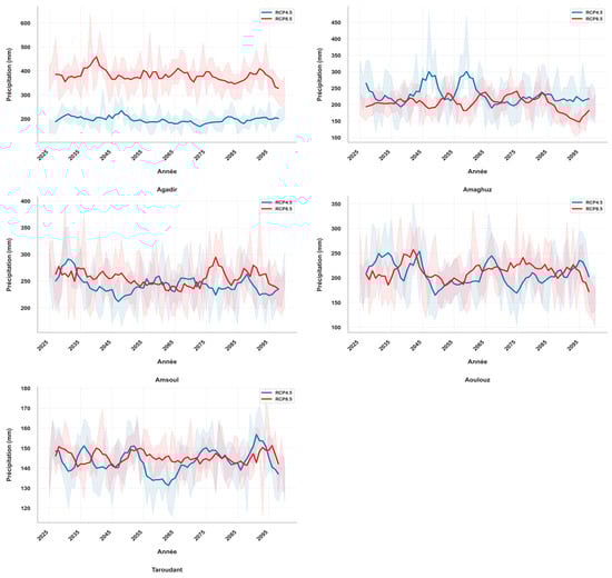
Figure 5.
Evolution of annual precipitation according to the (RCP 4.5) and (RCP 8.5) scenarios during the period 2025–2099 at five stations in the Souss-Massa watershed.
Conversely, the RCP8.5 scenario emphasizes the extent of the increase in the precipitation deficit. The annual average values projected are 196.36 mm in Agadir, 198.12 mm in Amaghouz, 243.23 mm in Amsoul, 206.48 mm in Aoulouz, and 143.24 mm in Taroudant. The reduction varies from −15.0% in Taroudant to −53.8% in Agadir, which shows high sensitivity and a 43% point difference between the two scenarios. On the other hand, the differences between the RCP 4.5 and 8.5 scenarios for the other stations are relatively small, with all being below 4% and showing low sensitivity to the increase in radiative forcing. Based on climate projections over the period 2024–2099, the precipitation is thus expected to decrease over the watershed, with strong differences between scenarios and stations. These projections represent the possible effects of different scenarios of greenhouse gas concentration on precipitation regimes over the Souss-Massa watershed.
These spatial differences are likely controlled by elevation gradients, orographic effects, and regional atmospheric circulation patterns.
3.3.2. Temperature
For the Souss-Massa region, extending to 2099, a thermal projection analysis indicates a significant and widespread warming trend for the RCP 4.5 and RCP8.5 scenarios. In all cases, it is observed that the temperature will continue to rise above the historical reference periods (T_hist). This is an indication of asymmetric warming, where the T-min are rising faster than the T-max in the Souss-Massa region, as evidenced by the projected data in all the monitoring stations in the region (Figure 5). This pattern is confirmed by the projected slopes, which are systematically higher for T-min than for T-max, particularly under the high-emission RCP8.5 scenario; for instance, at the Agadir station, the T-min slope reaches 0.064 °C/year compared to 0.026 °C/year for T-max.
In the Agadir station, the projected maximum temperature is expected to attain or slightly exceed the 44 °C level after 2090, showing a significant increase compared to the historical T-max average of 27.7 °C. At the same time, the continuous increase in minimum temperatures reflects a significant enhancement of nocturnal warming, considerably contributing to the increase in the annual mean temperature.
An acceleration of warming becomes more pronounced after 2050 at the Amaghouz and Amsoul stations, where projected trends show a continued increase in T-mean throughout the remainder of the century. Inland stations such as Aoulouz and Taroudant show concurrent increases in T-min, T-mean, and T-max compared to their historical averages, where T_mean increases by 17.6 °C and 20.7 °C, respectively, highlighting the increased sensitivity to long durations of hot temperatures in inland regions.
The RCP8.5 scenario shows a continued trend for increasing temperatures up to the end of the century, while the RCP 4.5 shows a relative stability for temperature increases from around 2085 onwards. Based on these projections, it is evident that there is a gradual increase in temperatures, as well as a decline in precipitation levels, which is likely to lead to a gradual increase in aridity within the Souss-Massa region (Table 5).
Table 5.
Annual maximum, minimum, and mean temperatures by 2099 for the Agadir, Amaghouz, Amsoul, Aoulouz, and Taroudant stations under RCP 4.5 and RCP8.5 scenarios.
According to climate forecasts for the Souss-Massa watershed, temperatures are projected to consistently increase between 1982 and 2022, as well as between 2025 and 2099 (Figure 3 and Figure 6). Future forecasts for the years 2025–2099 under the RCP 4.5 scenario indicate significant temperature increases compared to the historical period. T-max could increase by +6.10 °C in Agadir, +6.58 °C in Amaghouz, +4.82 °C in Amsoul, +5.36 °C in Aoulouz, and +5.68 °C in Taroudant. For T-min, the increases would be +8.14 °C in Agadir, +6.94 °C in Amaghouz, +5.46 °C in Amsoul, +8.49 °C in Aoulouz, and +8.69 °C in Taroudant. The annual average T-mean could increase by +5.63 °C in Agadir, +6.41 °C in Amaghouz, +4.98 °C in Amsoul, +7.37 °C in Aoulouz, and +7.18 °C in Taroudant.
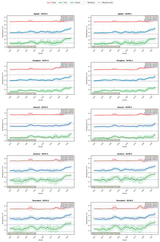
Figure 6.
Evolution of annual temperatures according to the (RCP 4.5) and (RCP 8.5) scenarios during the 2025–2099 period at five stations in the Souss-Massa watershed.
The high-emission RCP8.5 scenario makes temperature increases even more critical: +4.84 °C for T-max, +5.74 °C for T-min, and +4.99 °C for T-mean in Amsoul; +5.42 °C for T-max, +8.74 °C for T-min, and +7.46 °C for T-mean in Aoulouz; +5.82 °C for T-max, +8.74 °C for T-min, and +7.36 °C for T-mean in Taroudant; +6.42 °C for T-max, +8.74 °C for T-min, and +5.84 °C for T-mean in Agadir; and finally +6.65 °C for T-max, +7.04 °C for T-min, and +6.61 °C for T-mean in Amaghouz (Table 6, Table 7, Table 8, Table 9 and Table 10).
Table 6.
Evolution of annual temperature at the Agadir station.
Table 7.
Evolution of annual temperature at the Amaghouz station.
Table 8.
Evolution of annual temperature at the Amsoul station.
Table 9.
Evolution of annual temperature at the Aoulouz station.
Table 10.
Evolution of annual temperature at the Taroudant station.
These projections highlight the expected magnitude of temperature increases at the various stations studied, depending on greenhouse gas emission scenarios, and highlight the spatial heterogeneity of regional climate responses to global warming to global change.
Overall, the combined effects of increasing temperature and decreasing precipitation indicate a progressive intensification of aridity across the Souss-Massa watershed, particularly in inland areas, which may significantly increase pressure on regional water resources and agricultural sustainability.
The analysis of historical observations (1982–2022) and future projections (2025–2099) highlights consistent but contrasting climate responses in the Souss-Massa basin. While the temperature data show high statistical robustness, the precipitation data are more variable and uncertain for both past observations and future projections.
The results reveal two major characteristics of regional climate change. First, the temperature increase is statistically significant and spatially consistent across all stations considered. All climate projections indicate a warming trend until the end of the twenty-first century. Based on the RCP 4.5 and RCP8.5 scenarios, projected warming ranges between 1.3 and 8.7 °C by the year 2099, depending on the station and variable. Specifically, the projected increase in T-min reaches +8.74 °C in Aoulouz and +8.69 °C in Taroudant under the RCP8.5 scenario (Table 9 and Table 10), reflecting a severe intensification of nocturnal heat.
The historical climate trends identified in this study provide a vital context for understanding the implications of the forthcoming projections. The significant increase in temperature, as identified in the historical period, reveals that the projected increase in temperature is not just a result of model-based projections but, rather, is a continuation of the existing climatic shifts that are currently affecting the Souss-Massa basin.
These results are in agreement previous studies conducted at the Mediterranean and national levels. For example, Kusi et al. [42] showed increases in temperature and evapotranspiration by 2050 and 2090. Similar results have been reported by Attar et al. [43] and Díaz et al. [44], who estimated an average temperature increase of 1.5 to 6 °C by the end of the century in the Souss-Massa catchment. The magnitude of the historical warming detected in this study reinforces previously identified national trends, confirming the persistence of a long-term temperature increase in Morocco [26,45].
In contrast, precipitation projections remain more uncertain. Although a decreasing tendency appears in historical observations, the trends are not statistically significant due to the strong interannual variability typical of semi-arid climates. Nevertheless, climate projections consistently indicate a reduction in annual precipitation under both scenarios. Decreases range between 11% and 17% under RCP 4.5 and may reach up to −53.8% under RCP8.5 in coastal areas such as Agadir. These results align with previous studies projecting precipitation reductions between 10% and 20% by the end of the century [26,45], as well as MASEN (2014), which estimated decreases of 14–40% depending on model configurations.
The divergence between RCP 4.5 and RCP8.5 becomes increasingly pronounced after the mid-twenty-first century. Under RCP8.5, an additional warming of approximately 0.3–1.1 °C is projected by 2099 compared with RCP 4.5, confirming global assessments indicating that emission pathways strongly control late-century warming intensity [46]. Differences in precipitation response also display spatial variability, with coastal stations showing stronger sensitivity to high-emission scenarios, possibly linked to large-scale atmospheric circulation changes affecting Mediterranean storm tracks, as suggested by Driouech et al. [47]. For inland stations, the differences are relatively small (2–4 percentage points), which may indicate lower sensitivity to emission scenarios or larger uncertainties in precipitation simulation over continental regions. Recent research carried out within the Souss-Massa basin also confirms the reduction in precipitation and an increase in temperatures for both RCP 4.5 and RCP8.5 scenarios [34], thus supporting the consistency of the current results with the national climate projections.
The projected changes observed in the Souss-Massa basin are consistent with broader Mediterranean climate tendencies, suggesting that local climate evolution follows regional-scale warming and drying patterns [11]. The Fourth IPCC Assessment Report also shows warming of 2.5–5.5 °C by the end of the century depending on emission pathways [48]. Future projections also suggest the likelihood of drought events [49,50,51], in line with the trend of enhanced aridity in Morocco, especially in the north [52]. At the global scale, there are several semi-arid basins that display similar trends of increasing temperatures and decreasing rainfall [53,54,55]. On the other hand, there are areas that display a concurrent increase in both temperatures and rainfall [56,57,58], highlighting that the impacts of climate change are not uniform in nature.
The combination of strong warming and reduced precipitation has important implications for water resource management. Rising temperatures are expected to increase evapotranspiration rates, reduce soil moisture availability, and intensify irrigation demand. Increased minimum temperatures may additionally affect crop development and agricultural productivity through warmer nighttime conditions.
In the coastal region of Agadir, the large precipitation reduction expected in the RCP8.5 scenario could have severe impacts on water resources and agricultural production. Nevertheless, due to the level of uncertainty involved in precipitation projections, water and agricultural resources in the basin should be strengthened through adaptive management strategies based on multi-scenario climate projections.
4. Limitations and Uncertainties
Several important limitations should be acknowledged:
Modeling Constraints: The use of only the CanESM2 GCM implies that our results do not encompass the entire uncertainty range associated with different model formulations. A multi-model ensemble analysis would have been more reliable.
Statistical Downscaling: The assumption of stationarity in predictor-predictand relationships in the SDSM may become less valid under rapidly changing climate conditions.
Uncertainty in Precipitation: The high interannual variability of precipitation in semi-arid areas reduces the statistical power of trend analysis and thus the reliability of projections.
Extreme Projections: The extreme reduction in precipitation amount projected for Agadir in the RCP8.5 scenario should therefore be interpreted with caution and checked against other GCMs in future studies.
Bias Correction: The lack of systematic bias correction for GCM predictors could add extra uncertainty, especially for precipitation.
5. Conclusions
This study provides a comprehensive quantitative assessment of past and future climate change in the Souss-Massa watershed. The observed data (1982–2022) and statistically downscaled future projections (2025–2099) of the CanESM2 model under the RCP 4.5 and RCP8.5 scenarios were used to analyze historical trends and generate future climate projections. The results indicate substantial and statistically significant warming trends and uncertain but potentially large changes in precipitation, which have important implications for water resources and agricultural sustainability.
Historical analysis reveals a strong and significant warming trend at all five stations. Mean annual temperatures rose at rates from +0.28 to +0.45 °C per decade (p < 0.05), with the strongest rates of warming found at inland stations like Taroudant (+0.45 °C/decade) and Aoulouz (+0.41 °C/decade). Conversely, historical precipitation data, while negative at all stations (−0.91 mm/year at Agadir to −3.42 mm/year at Amsoul), lack statistical significance (p > 0.05 in most instances), reflecting the strong interannual variability characteristic of semi-arid climates.
The expected warming in the future is significant for both scenarios. Projected temperature increases by 2099 range between +4.8 °C and +8.7 °C, depending on the station, temperature variable, and scenario. The minimum temperatures are expected to increase the most, particularly in the RCP8.5 scenario, where temperatures increase by as much as +6.4 °C at Aoulouz. The difference between the scenarios will be large after 2050, with RCP8.5 expecting an extra 0.3–1.1 °C warming by the end of the century compared to RCP 4.5. The large difference between the two scenarios emphasizes the importance of mitigating greenhouse gas emissions to keep warming low in the latter part of the century. Changes in precipitation remain more uncertain compared to temperature projections. Under RCP 4.5, the decrease in annual precipitation amounts varies from −10.8% to −17.1% at the stations. Under RCP8.5, the reduction is more drastic, ranging from −15.0% to −53.8%, with the largest projected reduction occurring at the coastal station of Agadir. Although the Amaghouz, Amsoul, Aoulouz, and Taroudant stations in the inland regions project a relatively less drastic reduction, the spatial variability in the reduction is still large and is expected to be affected by physiographic factors such as elevation, topography, vegetation, and proximity to the Atlantic Ocean. The largest reduction projected at Agadir, although not impossible under high-emission scenarios, should be treated with caution due to model uncertainties. Precipitation projections are more uncertain than temperature projections.
The cumulative impact of strong warming and uncertain but mostly decreasing precipitation suggests a definite trend of increasing aridity in the Souss-Massa region. Even in the case where precipitation decline is not strong, warming will lead to increased evapotranspiration, reduced availability of soil moisture, and increased water demand. These projected changes are likely to pose significant challenges to water resource management, irrigated agriculture, and urban water supply.
These results provide a scientific foundation for evidence-based adaptation planning. Priority adaptation measures include: (1) the optimal management of water resources by artificial groundwater recharge and the use of non-conventional water sources such as desalination and wastewater reuse; (2) climate-smart agriculture by drought-tolerant crop varieties and more efficient irrigation; (3) the development of heatwave and drought-resistant infrastructure; (4) enhancing early warning systems for droughts and heatwaves; and (5) the use of a variety of plausible precipitation futures in long-term planning rather than a single deterministic projection.
Future research should aim to better quantify and reduce projection uncertainties. The key research priorities include: (1) applying multi-model ensembles to better represent uncertainties in projections, (2) downscaling other GCMs to validate the projection of extreme precipitation, particularly for coastal areas such as Agadir, (3) coupling climate projections with hydrological and agricultural impact models to evaluate the sector’s vulnerability, and (4) developing probabilistic climate scenarios to support risk-informed decision-making.
In conclusion, the Souss-Massa region is expected to face continuous warming and a possible precipitation reduction in the twenty-first century. While warming projections are robust and consistent, precipitation changes remain more uncertain but may lead to more severe hydrological impacts. Hence, effective adaptation and mitigation strategies will be required to ensure long-term water security and agricultural sustainability in the region.
Author Contributions
Conceptualization, M.E.-Y. and M.B., methodology, Y.B. and M.E.G., software, M.B., validation, M.B., B.B., H.T. and A.L., formal analysis, M.E.-Y., investigation, M.E.-Y., resources, M.E.-H. and Z.E.A.S., data curation, M.E.-Y., writing—original draft preparation, M.E.-Y., writing—review and editing, M.B., visualization, M.B., supervision, M.B., funding acquisition, B.B. and K.M.K. All authors have read and agreed to the published version of the manuscript.
Funding
This research work was supported by the Deanship of Scientific Research at King Khalid University under grant number: RGP2/649/46.
Data Availability Statement
The data presented in this study are available on request from the corresponding authors. The data are not publicly available due to privacy restrictions.
Acknowledgments
The Authors extend their appreciation to the Deanship of Scientific Research at King Khalid University for funding this work through large group Research Project under grant number: RGP2/649/46.
Conflicts of Interest
The authors declare no conflicts of interest.
References
- Zwiers, F.W.; Alexander, L.V.; Hegerl, G.C.; Knutson, T.R.; Kossin, J.P.; Naveau, P.; Nicholls, N.; Schär, C.; Seneviratne, S.I.; Zhang, X. Climate extremes: Challenges in estimating and understanding recent changes in the frequency and intensity of extreme climate and weather events. In Climate Science for Serving Society: Research, Modeling and Prediction Priorities; Springer: Dordrecht, The Netherlands, 2013; pp. 339–389. [Google Scholar] [CrossRef]
- Donat, M.G.; Alexander, L.V.; Yang, H.; Durre, I.; Vose, R.; Dunn, R.J.; Willett, K.M.; Aguilar, E.; Brunet, M.; Caesar, J.; et al. Updated analyses of temperature and precipitation extreme indices since the beginning of the twentieth century: The HadEX2 dataset. J. Geophys. Res. Atmos. 2013, 118, 2098–2118. [Google Scholar] [CrossRef]
- Chouhan, A.K.; Harsh, A.; Mishra, A.K.; Kumar, V.; Kumar, R.; Kumar, S. Delineation of groundwater vulnerable zone for sustainable development in the southwestern part of Bihar, India. Groundw. Sustain. Dev. 2024, 26, 101240. [Google Scholar] [CrossRef]
- López, J.J.; Ayuso-Muñoz, J.L.; Goñi, M.; Gimena, F.N. Analysis of the effect of climate change on the characteristics of rainfall in Igeldo-Gipuzkoa (Spain). Water 2023, 15, 1529. [Google Scholar] [CrossRef]
- Luterbacher, J.; Xoplaki, E.; Casty, C.; Wanner, H.; Pauling, A.; Küttel, M.; Brönnimann, S.; Fischer, E.; Fleitmann, D.; Gonzalez-Rouco, F.J. Mediterranean climate variability over the last centuries: A review. Dev. Earth Environ. Sci. 2006, 4, 27–148. [Google Scholar] [CrossRef]
- Giorgi, F. Climate Change Hot-spots. Geophys. Res. Lett. 2006, 33. [Google Scholar] [CrossRef]
- Lionello, P.; Scarascia, L. The relation between climate change in the Mediterranean region and global warming. Reg. Environ. Change 2018, 18, 1481–1493. [Google Scholar] [CrossRef]
- Cramer, W.; Guiot, J.; Fader, M.; Garrabou, J.; Gattuso, J.P.; Iglesias, A.; Lange, M.A.; Lionello, P.; Llasat, M.C.; Paz, S.; et al. Climate change and interconnected risks to sustainable development in the Mediterranean. Nat. Clim. Change 2018, 8, 972–980. [Google Scholar] [CrossRef]
- IPCC. Climate Change 2021: The Physical Science Basis. Contribution of Working Group I to the Sixth Assessment Report of the Intergovernmental Panel on Climate Change; Cambridge University Press: Cambridge, UK, 2021. [Google Scholar]
- Tramblay, Y.; Koutroulis, A.; Samaniego, L.; Vicente-Serrano, S.M.; Volaire, F.; Boone, A.; Le Page, M.; Llasat, M.C.; Albergel, C.; Burak, S. Challenges for drought assessment in the Mediterranean region under future climate scenarios. Earth-Sci. Rev. 2020, 210, 103348. [Google Scholar] [CrossRef]
- Schilling, J.; Freier, K.P.; Hertig, E.; Scheffran, J. Climate change, vulnerability and adaptation in North Africa with focus on Morocco. Agric. Ecosyst. Environ. 2012, 156, 12–26. [Google Scholar] [CrossRef]
- Driouech, F.; ElRhaz, K.; Moufouma-Okia, W.; Arjdal, K.; Balhane, S. Assessing future changes of climate extreme events in the CORDEX-MENA region using regional climate model ALADIN-climate. Earth Syst. Environ. 2020, 4, 477–492. [Google Scholar] [CrossRef]
- Lelieveld, J.; Proestos, Y.; Hadjinicolaou, P.; Tanarhte, M.; Tyrlis, E.; Zittis, G. Strongly increasing heat extremes in the Middle East and North Africa (MENA) in the 21st century. Clim. Change 2016, 137, 245–260. [Google Scholar] [CrossRef]
- Driouech, F.; Ben Rached, S.; El Hairech, T. Climate variability and change in North African countries. In Climate Change and Food Security in West Asia and North Africa; Springer: Dordrecht, The Netherlands, 2013; pp. 161–172. [Google Scholar] [CrossRef]
- Zittis, G.; Hadjinicolaou, P.; Klangidou, M.; Proestos, Y.; Lelieveld, J. A multi-model, multi-scenario, and multi-domain analysis of regional climate projections for the Mediterranean. Reg. Environ. Change 2019, 19, 2621–2635. [Google Scholar] [CrossRef]
- Bouchaou, L.; Tagma, T.; Boutaleb, S.; Hssaisoune, M.; El Morjani, Z.E.A. Climate change and its impacts on groundwater resources in Morocco: The case of the Souss-Massa basin. In Climate Change Effects on Groundwater Resources: A Global Synthesis of Findings and Recommendations; CRC Press: Boca Raton, FL, USA, 2011; pp. 129–144. [Google Scholar]
- IPCC. Climate Change 2007: Impacts, Adaptation and Vulnerability. Contribution of Working Group II to the Fourth Assessment Report of the Intergovernmental Panel on Climate Change; Cambridge University Press: Cambridge, UK, 2007. [Google Scholar]
- Hulme, M.; Doherty, R.; Ngara, T.; New, M.; Lister, D. African climate change: 1900–2100. Clim. Res. 2001, 17, 145–168. [Google Scholar] [CrossRef]
- Ben Kabbour, B.; Zouhri, L.; Mania, J. Overexploitation and continuous drought effects on groundwater yield and marine intrusion: Considerations arising from the modelling of Mamora coastal aquifer. Hydrol. Processes 2005, 19, 3765–3782. [Google Scholar] [CrossRef]
- Cudennec, C.; Leduc, C.; Koutsoyiannis, D. Dryland hydrology in Mediterranean regions—A review. Hydrol. Sci. J. 2007, 52, 1077–1087. [Google Scholar] [CrossRef]
- Carneiro, J.F.; Boughriba, M.; Correia, A.; Zarhloule, Y.; Rimi, A.; El Houadi, B. Evaluation of climate change effects in a coastal aquifer in Morocco using a density-dependent numerical model. Environ. Earth Sci. 2010, 61, 241–252. [Google Scholar] [CrossRef]
- Sebbar, A.; Badri, W.; Fougrach, H.; Hsaine, M.; Saloui, A. Study of rainfall variability in northern Morocco (1935–2004). Sécheresse 2011, 22, 139–148. [Google Scholar] [CrossRef]
- Ouhamdouch, S.; Bahir, M.; Souhel, A.; Paula, C. Vulnerability and impact of climate change processes on water resource in semi-arid areas: In Essaouira Basin (Morocco). In Energy, Transportation and Global Warming; Springer International Publishing: Cham, Switzerland, 2016; pp. 719–736. [Google Scholar] [CrossRef]
- Ouhamdouch, S.; Bahir, M. Climate change impact on future rainfall and temperature in semi-arid areas (Essaouira Basin, Morocco). Environ. Processes 2017, 4, 975–990. [Google Scholar] [CrossRef]
- Ouhamdouch, S.; Bahir, M.; Ouazar, D.; Carreira, P.M.; Zouari, K. Evaluation of climate change impact on groundwater from semi-arid environment (Essaouira Basin, Morocco) using integrated approaches. Environ. Earth Sci. 2019, 78, 449. [Google Scholar] [CrossRef]
- Mokssit, A. The state of climate change in Morocco. In Environment and Climate Change in Morocco: Diagnosis and Perspectives; Konrad-Adenauer-Stiftung e.V.: Rabat, Morocco, 2012; pp. 35–40. [Google Scholar]
- Filahi, S.; Tanarhte, M.; Mouhir, L.; El Morhit, M.; Tramblay, Y. Trends in indices of daily temperature and precipitations extremes in Morocco. Theor. Appl. Climatol. 2016, 124, 959–972. [Google Scholar] [CrossRef]
- Marchane, A.; Tramblay, Y.; Hanich, L.; Ruelland, D.; Jarlan, L. Climate change impacts on surface water resources in the Rheraya catchment (High Atlas, Morocco). Hydrol. Sci. J. 2017, 62, 979–995. [Google Scholar] [CrossRef]
- Jemai, H.; Ellouze, M.; Abida, H.; Laignel, B. Spatial and temporal variability of rainfall: Case of Bizerte-Ichkeul Basin (Northern Tunisia). Arab. J. Geosci. 2018, 11, 177. [Google Scholar] [CrossRef]
- Woillez, M.N. Literature Review on Climate Change in Morocco: Observations, Projections and Impacts; Agence Française de Développement: Paris, France, 2019; pp. 1–33. [Google Scholar] [CrossRef]
- Choukr-Allah, R.; Ragab, R.; Bouchaou, L.; Barceló, D. (Eds.) The Souss-Massa River Basin, Morocco; Springer: Berlin/Heidelberg, Germany, 2017. [Google Scholar] [CrossRef]
- Mansir, I.; Bouchaou, L.; Choukr-Allah, R.; Chebli, B.; El Otmani, M. Groundwater Resources Scarcity in Souss-Massa Region and Alternative Solutions for Sustainable Agricultural Development. In The Souss-Massa River Basin, Morocco; Springer: Berlin/Heidelberg, Germany, 2018; pp. 189–197. [Google Scholar] [CrossRef]
- Ait Brahim, Y.; Seif-Ennasr, M.; Malki, M.; N’da, B.; Choukrallah, R.; El Morjani, Z.E.A.; Sifeddine, A.; Abahous, H.; Bouchaou, L. Assessment of climate and land use changes: Impacts on groundwater resources in the Souss-Massa river basin. In The Souss-Massa River Basin; Springer: Berlin/Heidelberg, Germany, 2017; pp. 121–142. [Google Scholar] [CrossRef]
- El-Yazidi, M.; Benabdelhadi, M.; Laaraj, M.; Boutallaka, M.; El-Hamdouny, M. Comparative Study of Observed and Projected Future Climate Evolution in Two Watersheds (Souss-Massa and Ouergha, Morocco) Using the Statistical Downscaling Model (SDSM). In BIO Web of Conferences; EDP Sciences: Les Ulis, France, 2024; Volume 115, p. 03003. [Google Scholar] [CrossRef]
- Bouchaou, L.; Michelot, J.L.; Vengosh, A.; Hsissou, Y.; Qurtobi, M.; Gaye, C.B.; Bullen, T.D.; Zuppi, G.M. Application of multiple isotopic and geochemical tracers for investigation of recharge, salinization, and residence time of water in the Souss-Massa aquifer, southwest of Morocco. J. Hydrol. 2008, 352, 267–287. [Google Scholar] [CrossRef]
- Bouragba, L.; Mudry, J.; Bouchaou, L.; Hsissou, Y.; Krimissa, M.; Tagma, T.; Michelot, J.L. Isotopes and groundwater management strategies under semi-arid area: Case of the Souss upstream basin (Morocco). Appl. Radiat. Isot. 2011, 69, 1084–1093. [Google Scholar] [CrossRef]
- Kendall, M.G. A new measure of rank correlation. Biometrika 1938, 30, 81–93. [Google Scholar] [CrossRef]
- Kendall, M.G.; Gibbons, J.D. Rank Correlation Methods; Oxford University Press: Oxford, UK, 1962. [Google Scholar]
- Mann, H.B. Nonparametric tests against trend. Econometrica 1945, 13, 245–259. [Google Scholar] [CrossRef]
- Wilby, R.L.; Dawson, C.W.; Barrow, E.M. SDSM—A decision support tool for the assessment of regional climate change impacts. Environ. Model. Softw. 2002, 17, 145–157. [Google Scholar] [CrossRef]
- Musie, M.; Sen, S.; Srivastava, P. Application of CORDEX-AFRICA and NEX-GDDP datasets for hydrologic projections under climate change in Lake Ziway sub-basin, Ethiopia. J. Hydrol. Reg. Stud. 2020, 31, 100721. [Google Scholar] [CrossRef]
- Kusi, K.K.; Khattabi, A.; Mhammdi, N. Evaluating the impacts of land use and climate changes on water ecosystem services in the Souss watershed, Morocco. Arab. J. Geosci. 2023, 16, 126. [Google Scholar] [CrossRef]
- Attar, O.; Brouziyne, Y.; Bouchaou, L.; Chehbouni, A. A Critical Review of Studies on Water Resources in the Souss-Massa Basin, Morocco: Envisioning a Water Research Agenda for Local Sustainable Development. Water 2022, 14, 1355. [Google Scholar] [CrossRef]
- Díaz, J.P.; Pérez, J.C. Climate projections for the Souss Massa Drâa region: Decades 2045-55 and 2090–2100. In Proceedings of the Seminar for Dissemination of the Climate Project Results, Agadir, Morocco, 2014. [Google Scholar]
- Kingdom of Morocco. National Communication of Morocco to the United Nations Framework Convention on Climate Change; Kingdom of Morocco: Rabat, Morocco, 2016. [Google Scholar]
- Pörtner, H.O.; Roberts, D.C.; Masson-Delmotte, V.; Zhai, P.; Tignor, M.; Poloczanska, E.; Weyer, N. The ocean and cryosphere in a changing climate. In IPCC Special Report on the Ocean and Cryosphere in a Changing Climate; IPCC: Geneva, Switzerland, 2019; Available online: https://www.ipcc.ch/srocc/ (accessed on 1 January 2026).
- Driouech, F.; Déqué, M.; Mokssit, A. Numerical simulation of the probability distribution function of precipitation over Morocco. Clim. Dyn. 2009, 32, 1055–1063. [Google Scholar] [CrossRef]
- Meehl, G.A.; Stocker, T.F.; Collins, W.D.; Friedlingstein, P.; Gaye, A.T.; Gregory, J.M.; Kitoh, A.; Knutti, R.; Murphy, J.M.; Noda, A. Global climate projections. In Climate Change 2007: The Physical Science Basis. Contribution of Working Group I to the Fourth Assessment Report of the Intergovernmental Panel on Climate Change; Cambridge University Press: Cambridge, UK, 2007. [Google Scholar]
- El-Yazidi, M.; Dafouf, S.; El-Yazidi, O.; Benabdelhadi, M. Characterization of climatic drought in the Souss-Massa watershed (Morocco) using the Standardized Precipitation Index (SPI). In BIO Web of Conferences; EDP Sciences: Les Ulis, France, 2024; Volume 115, p. 01032. [Google Scholar] [CrossRef]
- Lionello, P.; Malanotte-Rizzoli, P.; Boscolo, R. (Eds.) Mediterranean Climate Variability; Elsevier: Amsterdam, The Netherlands, 2006; p. 4. [Google Scholar]
- IPCC. Climate Change 2013: The Physical Science Basis. Contribution of Working Group I to the Fifth Assessment Report of the Intergovernmental Panel on Climate Change; Cambridge University Press: Cambridge, UK, 2013. [Google Scholar]
- Driouech, F.; Déqué, M.; Sánchez-Gómez, E. Weather regimes-Moroccan precipitation link in a regional climate change simulation. Glob. Planet. Change 2010, 72, 1–10. [Google Scholar] [CrossRef]
- Daramola, M.T.; Xu, M. Recent changes in global dryland temperature and precipitation. Int. J. Climatol. 2022, 42, 1267–1282. [Google Scholar] [CrossRef]
- Zhou, J.; He, D.; Xie, Y.; Liu, Y.; Yang, Y.; Sheng, H.; Guo, H.; Zhao, L.; Zou, R. Integrated SWAT model and statistical downscaling for estimating streamflow response to climate change in the Lake Dianchi watershed, China. Stoch. Environ. Res. Risk Assess. 2015, 29, 1193–1210. [Google Scholar] [CrossRef]
- Bokhari, S.A.A.; Ahmad, B.; Ali, J.; Ahmad, S.; Mushtaq, H.; Rasul, G. Future climate change projections of the Kabul River Basin using a multi-model ensemble of high-resolution statistically downscaled data. Earth Syst. Environ. 2018, 2, 477–497. [Google Scholar] [CrossRef]
- Huang, J.; Zhang, J.; Zhang, Z.; Xu, C.; Wang, B.; Yao, J. Estimation of future precipitation change in the Yangtze River basin by using statistical downscaling method. Stoch. Environ. Res. Risk Assess. 2011, 25, 781–792. [Google Scholar] [CrossRef]
- Khadka, D.; Pathak, D. Climate change projection for the Marsyangdi river basin, Nepal using statistical downscaling of GCM and its implications in geodisasters. Geoenviron. Disasters 2016, 3, 1–15. [Google Scholar] [CrossRef]
- Fenta Mekonnen, D.; Disse, M. Analyzing the future climate change of Upper Blue Nile River basin using statistical downscaling techniques. Hydrol. Earth Syst. Sci. 2018, 22, 2391–2408. [Google Scholar] [CrossRef]


Disclaimer/Publisher’s Note: The statements, opinions and data contained in all publications are solely those of the individual author(s) and contributor(s) and not of MDPI and/or the editor(s). MDPI and/or the editor(s) disclaim responsibility for any injury to people or property resulting from any ideas, methods, instructions or products referred to in the content. |
© 2026 by the authors. Licensee MDPI, Basel, Switzerland. This article is an open access article distributed under the terms and conditions of the Creative Commons Attribution (CC BY) license.