4.1. Case Study Description
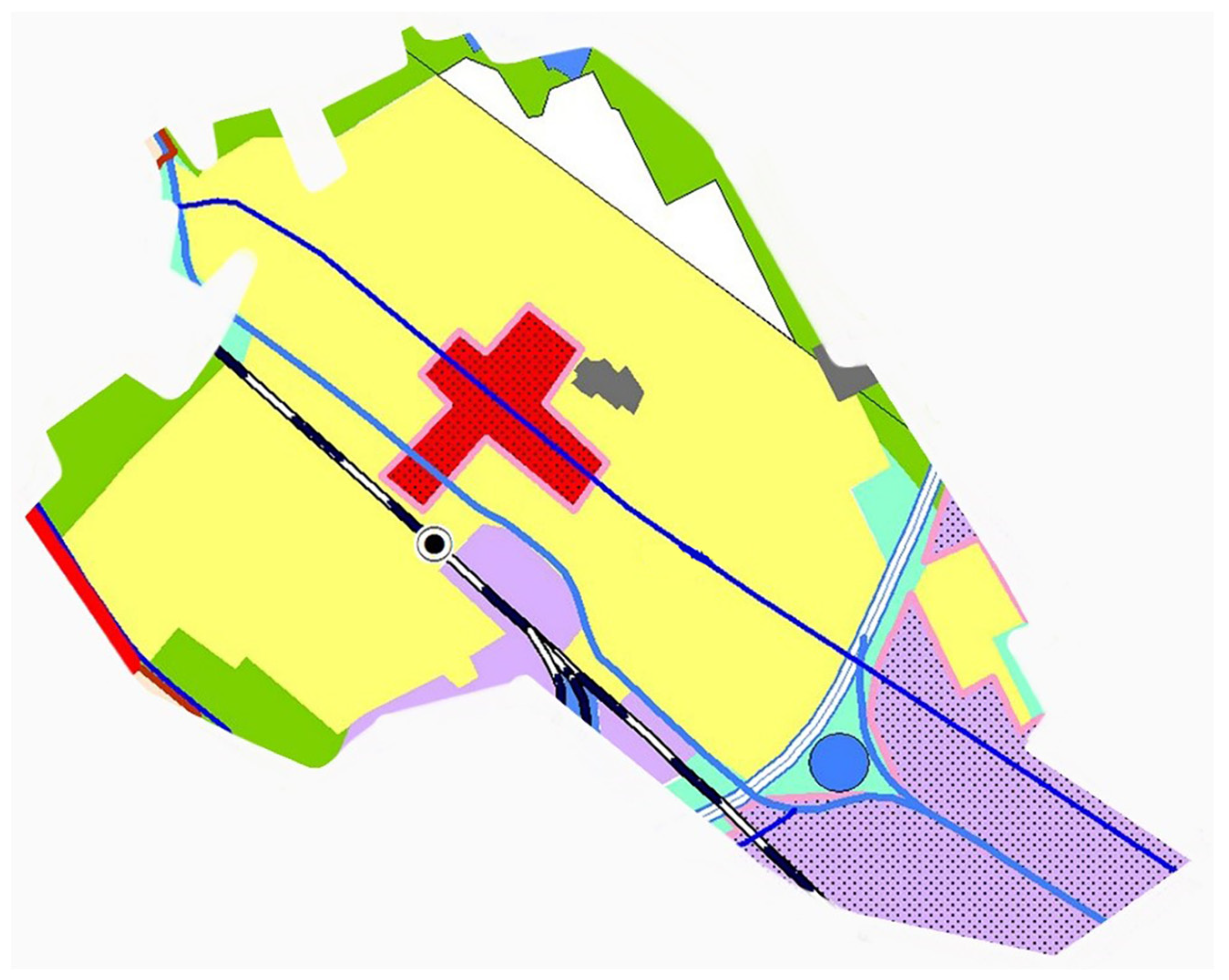
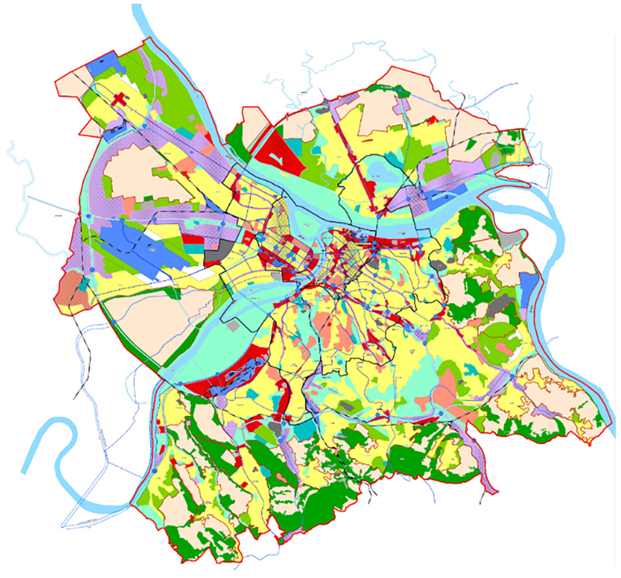
In this section of the paper, the focus is on establishing the groundwork for addressing the warehouse location selection problem. The initial foundation of the problem involves identifying and forming a list of alternatives for consideration, as well as a list of criteria by which the alternatives are assessed using appropriate methods. The primary challenge in implementing the proposed methodology lies in gathering information during interviews, as well as in defining criteria, alternatives, and their evaluations. Consequently, it would be most beneficial to conduct interviews with all experts simultaneously, facilitating the exchange of thoughts and perspectives, contributing to more robust information. For practitioners, a challenge may arise in the application of the model, particularly for those unfamiliar with MCDM methods. This challenge can be easily addressed by using the proposed model through Excel or by developing an application with a user-friendly interface. The model’s limitation is evident in its challenging application to problems with extremely large dimensions (given the large number of alternatives that need evaluation in accordance with criteria), although such situations are rare, especially in solving FLP where the number of potential alternatives is not typically substantial. The list of alternatives essentially comprises potential solutions, among which the optimal one must be chosen—the one that will most effectively satisfy the specified criteria. Potential locations were determined based on interviews with experts from the observed company who considered them for the establishment of a new warehouse. The preliminary foundation for selecting the warehouse location included the general urban plan of the city of Belgrade, illustrated in
Figure 2. Areas designated for facility locations such as warehouses are highlighted in purple (industrial zones) and red (commercial facilities). Accordingly, locations with such designated areas were taken into consideration.
The following locations were selected as potential alternatives for establishing the warehouse:
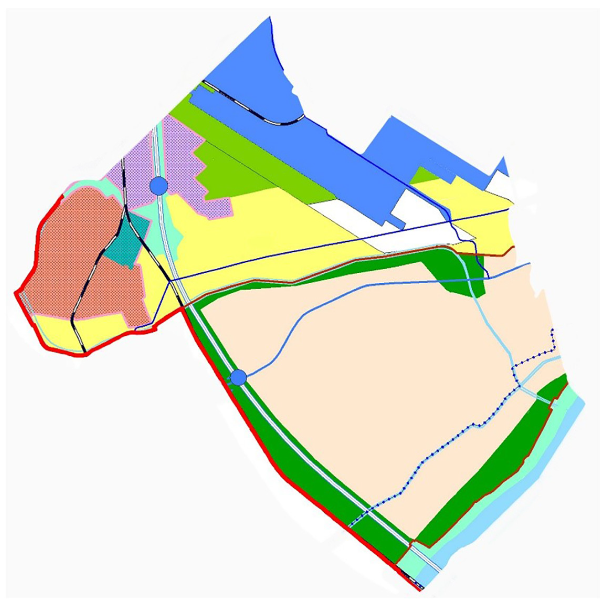
A1—Borča—The land price per square meter at this location is estimated at EUR 24.19 [
31]. In terms of infrastructure access, Borča is intersected by Zrenjaninski Put, providing a connection to the E70 highway and the Pančevački Most. A crucial road link is facilitated by Pupinov Most, spanning the Danube River and linking Borča to central areas of Belgrade (
Figure 3). This location is situated 26.7 km away from Belgrade, with a required driving time of 35 min [
32]. Borča offers substantial site capacities, although they are smaller compared to Surčin and Dobanovci. This location does not have significant competitors, indicating that there is not a high demand for skilled labor, and a considerable number of qualified workers are available.
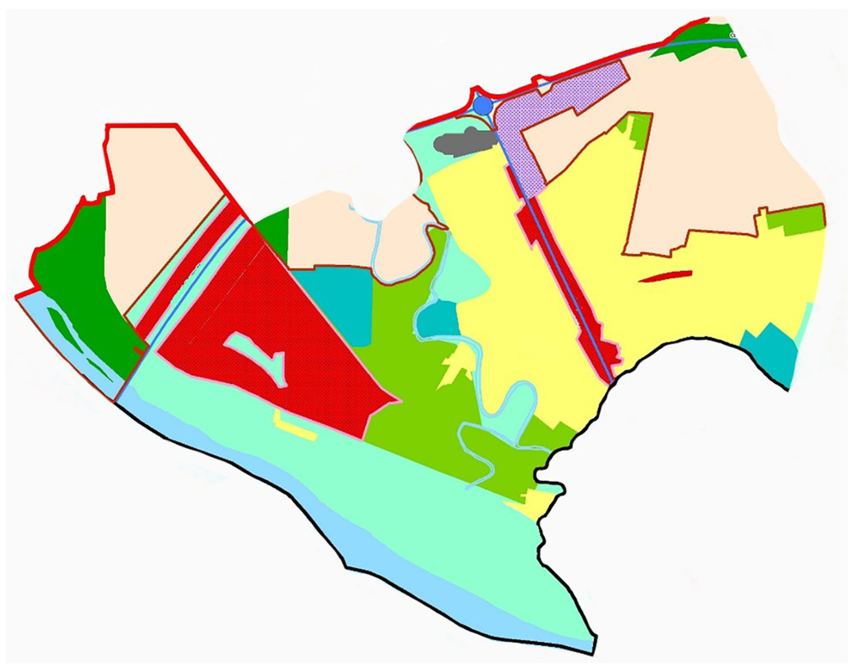
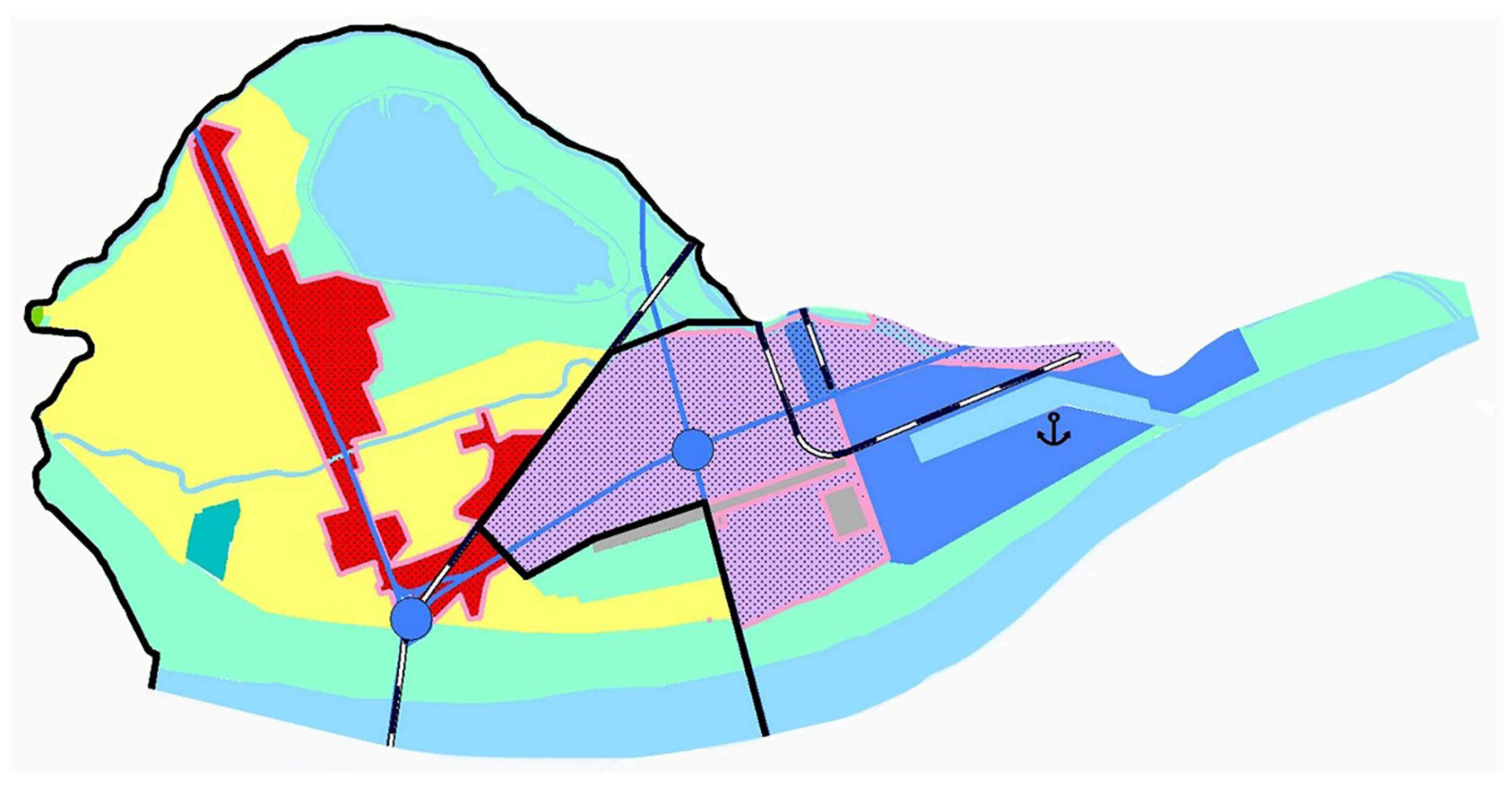
A2—Surčin—The estimated land price per square meter at this location is EUR 22.76 [
31]. In terms of infrastructure, this location boasts access to the state road, linking Leštane–Grocka–Petrijevo–Ralja, serving as a connection to the A1 state road. Surčin is well connected to the E70 and E75 highways. The E70, running east–west, connects Surčin to Belgrade and further west to the Serbian border. The E75, spanning north–south, links Surčin to Belgrade and extends south through Serbia. These highway connections position Surčin as a significant transportation hub, facilitating the movement of goods between Belgrade and other parts of Serbia, as well as neighboring countries. Surčin is renowned for the “Nikola Tesla” airport, a crucial air traffic hub in Serbia that plays a vital role in connecting Belgrade with other cities and countries. Located on the southern edge of the Pannonian Plain along the Sava River, it provides a navigable route connecting with the Danube River as European Corridor 7 [
33]. Surčin is 31.5 km away from Belgrade, with a delivery time of 34 min [
32]. Surčin is situated within an industrial zone, and its capacities are smaller compared to those present in Dobanovci. As it is an industrial zone with numerous competitors, there is a high demand for skilled labor (
Figure 4).
A3—Batajnica—The estimated land price per square meter at this location is EUR 25.07 [
31]. In terms of infrastructure access, Batajnica is connected to the state road, linking it to the A1 state road Batajnica–Ugrinovci–Surčin, and state road Horgoš–Subotica–Bačka Topola–Mali Iđoš–Srbobran–Novi Sad–Sremski Karlovci–Inđija–Stara Pazova–Belgrade. It is essential to mention the Batajnica loop, approximately 3.5 km in length, enhancing transportation connectivity and facilitating the flow of goods and services, connecting Batajnički Boulevard and the intermodal transport logistics center to the E-75 highway. There is also good connectivity to the railway network via the mainline of railway 111 Belgrade “A”–Ostružnica–Batajnica [
34]. The Batajnica intermodal terminal promotes the development of modern combined cargo transport by increasing the railway’s share and creating a partnership with road transport. Batajnica is located 22.1 km from Belgrade, requiring a 32 min drive [
32]. Batajnica has relatively smaller location capacities compared to other alternatives. Strong competitors are not present at this location, indicating a higher availability of skilled labor (
Figure 5).
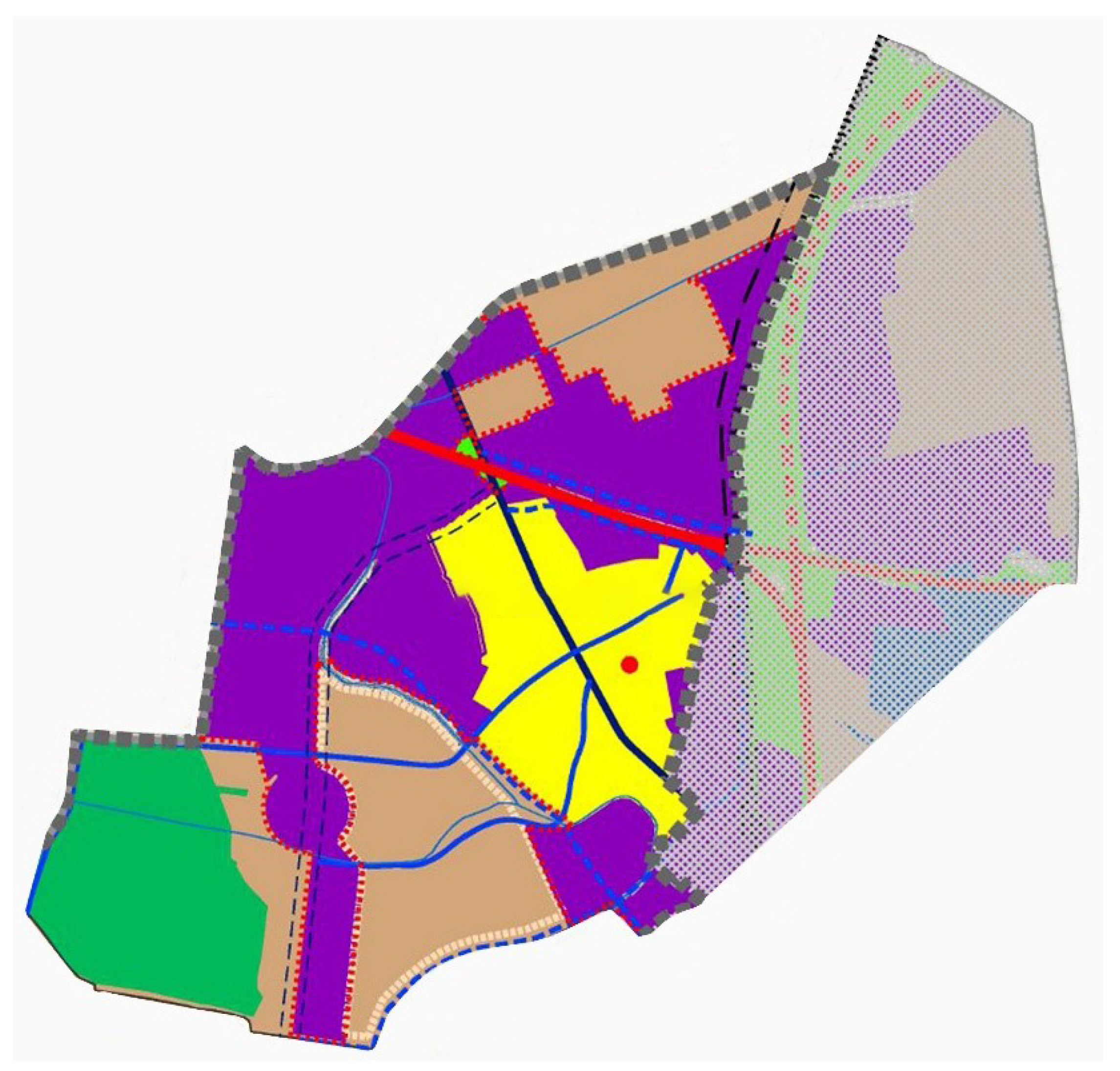
A4—Krnjača—The estimated land price per square meter at this location is EUR 25.5 [
31]. Krnjača is connected to the state road Horgoš–Kanjiža–Novi Kneževac–Čoka–Kikinda–Zrenjanin–Čenta–Belgrade. Additionally, it is crucial to note that Krnjača is situated near the E70 highway, alongside which Zrenjaninski put stretches, and has a direct connection to Belgrade via the Pančevački Most. There is also connectivity to railway traffic through the Krnjača railway station located on the left bank of the Danube River. The railway continues towards Krnjača in one direction and Pančevački Most in the other. The distance on the Krnjača–Belgrade route is 10.7 km, requiring approximately 19 min of travel time [
32]. The capacity of the Krnjača location is larger than Batajnica but smaller than other locations. There are competitors present, but not to a significant extent. As mentioned for Batajnica, the same applies to Krnjača; namely, due to a lack of competitors, there is a higher availability of qualified labor (
Figure 6).
A5—Dobanovci—The estimated land price per square meter at this location is EUR 20.18 [
31]. Dobanovci is characterized by excellent traffic connectivity with major road networks, including the E70 and E75 highways, as well as the M2 Miloš Veliki highway. Notably, there is an intermodal terminal situated within the central distribution-logistics center in Dobanovci, connected by rail to all major European ports and land terminals. The Dobanovci railway station serves as a crucial hub in the railway system, offering transportation services for both passengers and goods and facilitating substantial connectivity to the railway network. The distance from Belgrade is 22.8 km, covering a journey time of approximately 23 min [
32]. A distinctive feature of Dobanovci is that it boasts the largest capacities for expansion and future warehouse development. Concerning the presence of a large number of competitors in this area, challenges may arise in attracting and retaining qualified labor due to increased demand, indicating a shortage of available skilled workforce (
Figure 7).
Once the list of potential alternatives was formulated, the next step involved identifying criteria to facilitate the final decision-making process, specifically the selection of the optimal location from the available options. The identification and definition of criteria, which would vary among alternatives, needed to align with desired objectives, as they represent the preferred characteristics of potential solutions. Following the establishment of the final list of criteria with distinct variations, acknowledging that not every criterion holds equal importance, the subsequent task was to determine their respective weights. The quantitative expression of these weights signifies their significance and influence on the ranking of alternatives, culminating in the ultimate decision. Through these weights, the priorities and preferences of the decision-maker are reflected. For the evaluation of the specified alternatives or potential locations, the following criteria were applied (
Table 2) [
26,
27,
35,
36]:
C1—Land Cost. This criterion serves as a crucial factor in warehouse construction and directly impacts the escalation of investment costs. Beyond the required land area for the warehouse, there must also be sufficient additional surrounding space available for future development and expansion.
C2—Infrastructure Access. Transportation facilitates the movement of goods from producers to warehouses, between various warehouses, and from warehouses to retail or end customers. A warehouse must have excellent connectivity with transportation networks, including highways, railways, river ports, and airports to facilitate this transportation.
C3—Workforce Availability. Warehouse facilities require a qualified workforce to perform various tasks, ranging from handling inventory and order picking to managing warehouse operations. A qualified workforce in the warehouse includes employees who are trained and experienced in executing diverse warehouse tasks. This criterion is closely tied to C5, as increased competitiveness in the environment implies a higher demand for a skilled workforce.
C4—Delivery Time. This is directly linked to criterion C2 but also depends on the destination. For this study, the central location of Belgrade has been selected as the destination. It is of paramount importance since a short delivery time contributes to customer satisfaction, enhances adaptability to market changes, facilitates gaining a competitive advantage, and more.
C5—Area Competitiveness. This refers to the level of competition in the environment. The less competitive the environment, the better the location’s result.
C6—Location Capacity. This relates to the location’s ability to support the necessary warehouse capacities, including space for storing goods, handling cargo, parking for delivery vehicles, space for installing specific equipment and technology, and other required resources. This criterion also pertains to the location’s availability for future expansions and warehouse development.
C7—Presence of Various Transportation Modes. The ability to utilize multiple transportation modes is crucial for adapting to diverse transport requirements and optimizing transportation costs.
4.2. Results
As previously outlined, the initial step involves the application of the IMF SWARA method to derive criteria weights. Determining the weights begins with ranking the criteria based on their significance, from the most significant to the least. Subsequently, experts utilize linguistic scales, which are then converted into fuzzy numbers (
Table 3). Five experts from the observed company (LSP) participated in the evaluation. Among the overall pool of experts, two are engaged as logistics managers, another two hold positions as warehouse managers, and one assumes the role of a supply chain manager. All of the experts have more than 10 years of working experience. In the assessment process involving multiple experts, the chosen unified value corresponds to the one that occurs most frequently during the evaluation process.
Based on
Table 3, it can be inferred that the most significant criterion is C1—land cost, given its direct impact on overall investments in establishing a warehouse and its potential decisive significance. Land price constitutes a portion of the total costs associated with facility setup. Companies often face financial constraints, and the cost of land is a pivotal factor in determining whether a specific location is viable within budget constraints. Following this, a slightly less significant criterion is C2—infrastructure access, representing a crucial element for timely and cost-effective deliveries. Well-developed infrastructure helps minimize transportation costs. Efficient connectivity leads to shorter distances, reduced fuel consumption, and lower overall logistics costs. Proximity to major infrastructure nodes like highways, railways, and ports ensures efficient transportation of goods to and from the warehouse. Additionally, good transportation connectivity allows for quick adaptation in case one mode of transport encounters challenges such as road closures, strikes, roadworks, traffic congestion, etc., enabling the swift utilization of alternative routes or transport modes. Criterion C7—the presence of various transport modes—represents the ability to access multiple transport modes, thus providing flexibility in choosing the most efficient and economical transportation method based on specific needs and requirements. A slightly less significant criterion is C4—delivery time, impacting customer satisfaction, logistical chain efficiency, the fulfillment of requirements, and overall costs. Criterion C6—location capacity, relating to capacity for current and future needs, is essential for adapting to business operations and accommodating growing demand. A bit less significant is C5—area competitiveness, which may limit access to resources like qualified labor, infrastructure, or land availability. Moreover, intense competition may exert pressure to reduce service prices to attract clients. The last-ranked criterion is C3—workforce availability, contributing to improved warehouse operations management but is not of paramount importance, as companies can provide various training programs to employees, aiding in enhancing overall operational efficiency and performing various operations (
Table 4).
Following the determination of criteria weights, the MARCOS method was employed to rank potential locations. The initial decision-making matrix (
Table 5) was formed as the first step in implementing the MARCOS method. For quantitative criteria, precise values were utilized, while values for qualitative criteria were derived from expert assessments, where experts evaluated criteria using a scale of 1–5.
The presented values were then normalized using Equations (8) and (9), depending on the type of criteria. The normalized values are shown in
Table 6.
The normalized values were then multiplied by the corresponding criterion weights obtained after applying the IMF SWARA method. This way, the weighted decision-making matrix was formed (
Table 7).
To perform the final ranking, Equations (11)–(16) were applied. After applying the described equations, a utility function value for every alternative was obtained, based on which the alternatives were ranked (
Table 8).
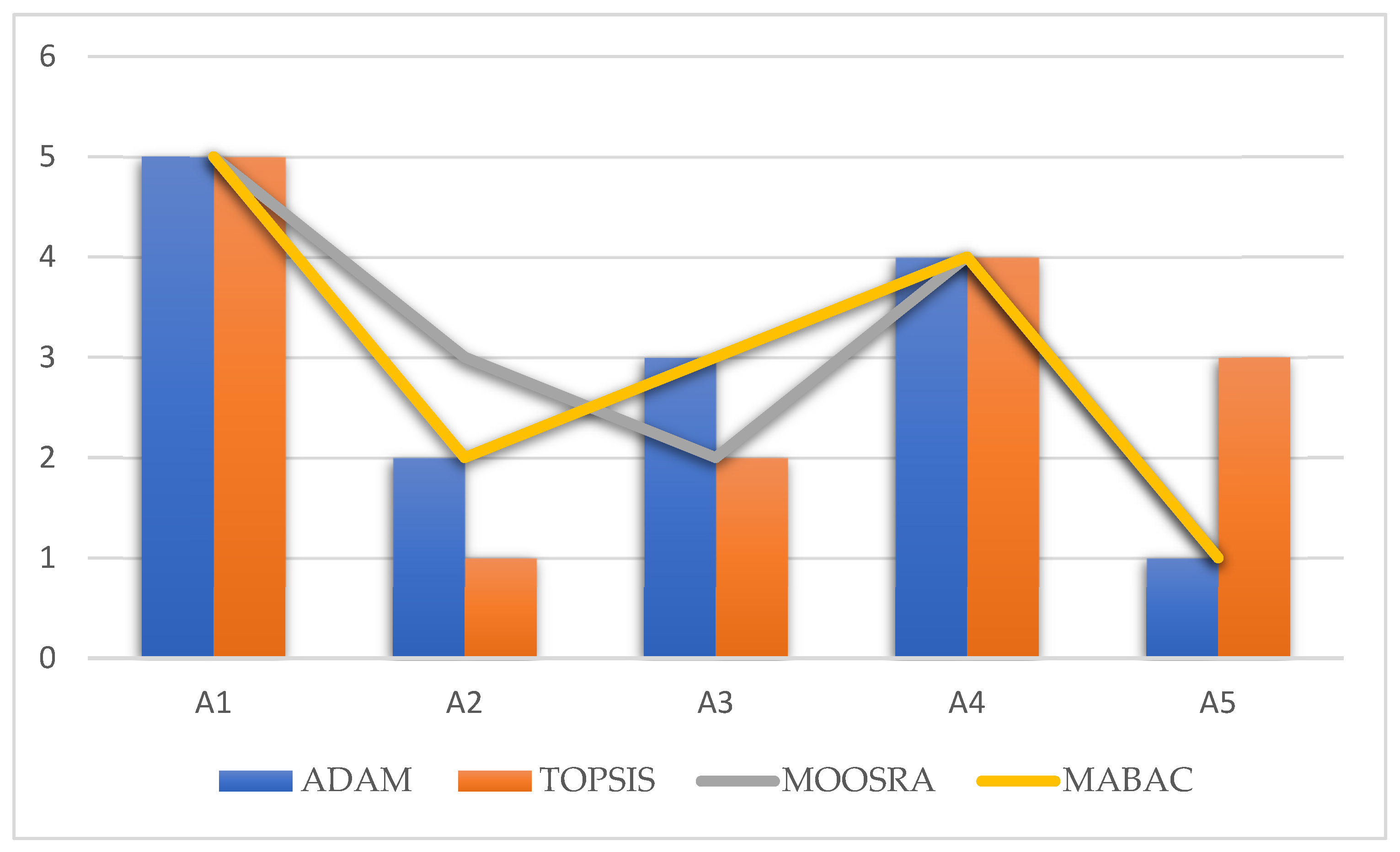
Based on the results in
Table 8, it can be concluded that the best-ranked alternative (potential location) is A5—Dobanovci, followed by A2 and A3 sharing the same position, and then A4 and A1. The alternative ranking can also be represented as A5 > A2 = A3 > A4 > A1. Based on the results, it can be inferred that criteria with higher weights (for example C1 and C2) exert a greater influence on the final ranking of alternatives, whereas, on the other hand, criteria with lower weights (for example C6 and C7) have a smaller impact. For this reason, sensitivity analysis was conducted in this study to assess whether there would be any changes in the ranking of alternatives.


