Abstract
The overall objective of the study is to generate information for an enhanced land use planning with respect to flood hazards. The study assesses the potential impact of climate change by simulating a dam break scenario in a high intensity rainfall event and evaluates the vulnerability risk in the downstream region by integrating ArcGIS and Hydrologic Engineering Centers River Analysis System (HEC-RAS) technologies. In the past century, the evidence of climate changes are observed in terms of increase in high intensity rainfall events. These events are of high concern, as increased inflow rates may increase the probability of a dam failure, leading to higher magnitude flooding events involving multiple consequences. The 100 year historical rainfall data for the central Mississippi region reveals an increased trend in the intensity of rainfall rates after the 1970s. With more than 10% of high hazard dams in the central region, the damage can be far accumulative. The study determines occurrence of the high intensity rainfall event in the past 100 years for central Mississippi and simulates a Ross Barnett Reservoir dam break scenario and evaluates the vulnerability risks due to inundation in the immediate downstream region, which happens to be the State Capital. The results indicate that the inundation due to a Ross Barnett Reservoir failure under high intensity rainfall event is comparable to a catastrophic flood event experienced by the region in 1979, which almost equals a 200-year flood magnitude. The results indicate that the extent and depth of flood waters poses a significant destructive threat to the state capital, inundating various infrastructural and transportation networks.
1. Introduction
According to the Intergovernmental Panel on Climate Change (IPCC), over the 20th century, the observed temperature and precipitation changes in the United States was quite higher than the rest of the world [1]. The predicted temperature changes in central North America are higher than the global mean values [2], because of higher latitudes. The central USA witnessed significant changes in temperature and rainfall, and according to the United States Environmental Protection Agency (USEPA) report [3], over the last century, the precipitation levels in Mississippi have increased by about 20% over the mean annual rainfall and are predicted to rise by 5–25% in the coming century throughout the state. The evidence of the climate changes is observed not only in terms of increase in the average rainfall, but also in terms of increase in the intensity (The greatest depth of precipitation for a given duration that is physically possible over a given area at a particular geographical location at a certain time of year) of precipitation events, which is of high concern towards flooding problems [1].
The climatic changes have disastrous consequences that impact physical systems, infrastructure and social organization in many ways. Floods can also be categorized as high-impact events, as they involve multiple consequences, such as disruptions in the transportation and communication sectors, property damage and prolonged submergence of agricultural lands, wetlands, etc. The disaster effects are greatest for floods than any other calamity. Of all the natural calamities, floods can be described as catastrophic events whose impact lasts for a long period of time. The 100 year historical rainfall data for the central Mississippi region reveals an increased trend in the intensity of rainfall rates after 1970s (Figure 1). These events are of high concern, as increased inflow rates may increase the probability of a dam failure, leading to higher magnitude flooding events involving multiple consequences. In a report prepared by the city of Roseville, CA, climate change effects trigger the probability of dam failure, as dams are designed based on the assumptions about the river flow behavior or hydrographs. The changes in the weather patterns due to climate change effects can bring significant effects on hydrographs used for the design of the dam [4]. In case of a dam failure in these rainfall events, the damage can be far more severe and accumulative to the State of Mississippi, with 277 high hazard dams.
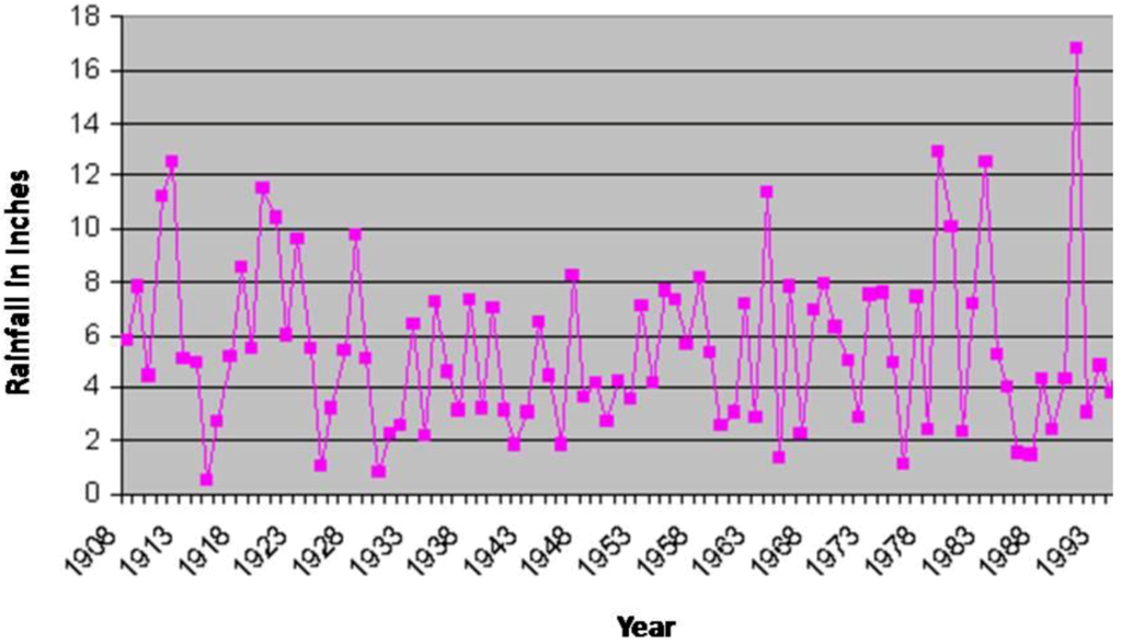
Figure 1.
Intensity of the rainfall events after 1970 in the central Mississippi region.
Figure 1.
Intensity of the rainfall events after 1970 in the central Mississippi region.

1.1. Background Information
In the United States, flash floods are the leading cause of weather related mortality [5], and the gulf coast region is especially subject to extreme floods. The state of Mississippi ranks eighth [6] and stands among the worst flood-hit states in the nation, with a repetitive number of flash floods occurring from short and intense rainfall events. Extreme inflow rates resulting from these intense rainfall events increase the probability of an eventual dam failure and subsequent flash floods [6]. Many of the existing dams in the US do not have adequate capacity to handle extreme inflows from the intense rainfall events [7]. One such incident happened when a 70-year rainfall event (13.54 cm of rainfall within 24-h) triggered a catastrophic failure of the Ivex dam on the Chagrin River in northeastern Ohio in 1994 [8]. Living in the downstream regions of a high hazard dam in such intense rainfall events doubles the hazard potential, posing severe threat to the lives and damaging infrastructure and property. In budget dollars per dam, Mississippi ranks 47th, leaving thousands of Mississippians to live below high and significant-hazard dams (Figure 2), which, without timely maintenance and inspection, become potentially lethal time bombs [9]. For central Mississippi, with the state capital situated downstream of a high hazard dam (Ross Barnett Reservoir dam), the outbreak of this dam in an event of high intense rainfall can prove to be devastating.
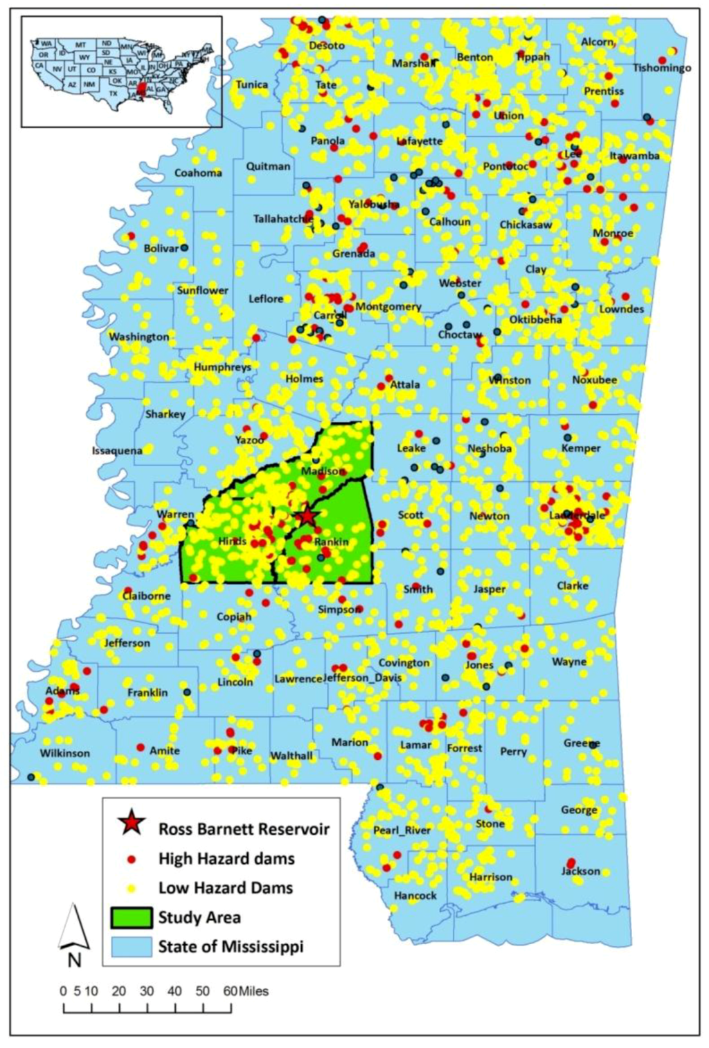
Figure 2.
Spatial location of high hazard dams in the State of Mississippi.
Figure 2.
Spatial location of high hazard dams in the State of Mississippi.
In its history, the City of Jackson had experienced one of the most catastrophic floods, the Pearl River flood of 1979, also known as the “Easter Flood of 1979”. According to a US Army Corps of Engineers report [10] the 1979 flood flows surpassed the records of past flood events, causing more than $200 million damage. The extent of damage was severe, as serious disruptions occurred to transportation and communications that blocked the State capital for a number of weeks. The 1979 flood was estimated as a 200-year flood event that left the City of Jackson with devastating damages.
Rutherford [11] describes the damages in the City of Jackson resulting from a flood hazard as a public policy disaster, which had occurred due to continuous developmental activities in the floodplain after the 1961 flood. Failure to integrate the vulnerable locations into the land use planning resulted in devastating conditions in the state capital.
1.2. History of Ross Barnett Reservoir Dam
The Ross Barnett Reservoir was built in 1960, located in the midst of the three most densely populated counties and economic centers of Mississippi, is one of the high hazard dams that lacks an Emergency Action Plan (MDEQ, Division of Dam safety, 2000). Further, the design lifetime of the earth-fill dam posing more risk to downstream region is of serious concern [12]. Despite flood control improvements of levees and clearing, the Jackson, MS, metropolitan area below the Ross Barnett Reservoir Dam suffers annual flood damages from the Pearl River of about $10 M [10].
A review of the literature suggests that a number of studies have been done for simulating dam break floods. Katopodes [13] examines the flooding patterns when a finite element method (Galerkin formulation) model is applied on a discontinuous channel flow. By comparing the results with the analytical solutions, the study rated the performance of the model to be poor. In another study, Hromadka [14] analyzes a two-dimensional dam-break model developed for a flood plain, with flow equations solving a diffusion model coupled to the equation of continuity. The study concludes this approach can better predict at a two-dimensional dam-break flood plain over a broad, flat plain more accurately than a one-dimensional model. Similarly, Akanbi [15] presented a model to indicate the changes in the behavior of flood waters propagating on a dry bed, and Zhao et al. [16] investigated the effects of changes in bed elevations on the flooding patterns using three defined solvers and concluded that these models are useful for studying levee failure or dam break due to extreme flood events. The capabilities of numerical models that simulate flooding due to failure of a dam/reservoir in a natural river were presented by Sharma [17]; Zoppou and Robert [18]. Preliminary review of these articles indicates that these studies focused on analyzing the differences between the flood model equations that were solved and estimated the level of stability and accuracy of the equations. These studies lack the application of results on the communities, which can facilitate in identifying vulnerable locations.
On the other hand, a MEMA report [12] presented examples of two dam break studies that have been executed for Oak Lake Dam (Rankin County) and Acacia Woods Lake Dam (Rankin County). In both cases, the dam break simulations were done at the normal water level failure and have not considered future possible dam failure due to extreme inflows caused by intense rainfall events. Another study on the Ross Barnett Reservoir by Davies [19] was done from a hydraulic analysis dimension. In spite of numerous studies, there exists a knowledge gap in identifying vulnerable locations due to dam failure and applying the results to enhance activities in planning and developmental fields.
1.3. Purpose of the Research
The purpose of the research is to analyze the vulnerability risks posed by potential flood hazard due to a dam failure in an event of intense rainfall event. In this context, the current study, by integrating ArcGIS and HEC-RAS technologies, simulated a dam break analysis triggered by extreme inflow resulting from an intense rainfall event. The study conducted a vulnerability risk assessment for the downstream regions from a cultural, socio-economic and infrastructural impact perspective.
1.4. Description of the Simulation Scenario
The 100 year historical precipitation data (1908–2007) for the central Mississippi region is collected from the National Climatic Data Center (http://www7.ncdc.noaa.gov/CDO/CDODivisionalSelect.jsp). A rainfall event with 16.75 inches/24 h (April 1991) was determined as the high intensity event in the past 100 years. The actual inflow data into the Ross Barnett Reservoir dam for this rainfall event is collected from the 02486000 USGS (United States Geological Survey) station, which happens to be 16,026 cubic feet per second. As the rainfall event has been experienced by the region in the past, a dam break simulation under this event provides the inundation risks on a typical scale (base flooding scenario) that have a high possibility of occurrence on any given day in a year [20].
1.5. Suitability of HEC-RAS for Dam Break Scenario Simulations
As the current study focuses on the spatial identification and vulnerability index development for the flood hazard, simulation of the flood scenarios are required to be conducted in a geospatial environment. The models should facilitate the capability of applying a geographic information system (GIS) to the flood simulations and assist in analyzing the flood levels or extents spatially. GIS helps in visualizing flood simulations in an interactive setting, where the spatial impact of various scenarios can be viewed along with the location of critical facilities and, thus, helps in assessing the region’s vulnerability towards a flood event efficiently [21]. In this connection, Bajwa and Tim [22] describes the 1-dimensional HEC-Geo models (HEC-GeoRAS developed by the US Army Corps of Engineers) as a geospatial hydrology toolkit that recognizes the power of the Arc-GIS environment in generating and visualizing flood simulations. The GeoRAS product developed by the US Army Corps of Engineers enables these flood simulation models to be compatible with the ArcGIS environment and provide valuable tools to evaluate impacts associated with flood plains [23]. Hicks and Peacock [24] strengthen the suitability and capability of HEC-RAS models in simulating floods by stating that the HEC-RAS flood simulations, examined through an application, shows accuracy comparable to more sophisticated hydraulic models.
Numerous studies have used HEC-RAS tools to evaluate dam break failures and subsequent flood hazards in a geospatial environment. Presently, many of the State and Federal agencies are using HEC-RAS for simulating dam failure scenarios to visualize the results in the GIS environment. The Oregon Department of Fish and Wildlife assessed Canyon Creek Meadows Dam failure affects using HEC-RAS 4.0. The Oregon State department has developed a scenario where a dam failure occurs due to high intensity rainfall events determined from 100 year historical data. A hydraulic model was developed for Canyon Creek to simulate a dam breach of the Canyon Meadows Dam. The geometric profile of the region, needed for the HEC-RAS dam breach model, was constructed from USGS 30-m digital elevation models (DEMs), inline structures and land use. The external boundary conditions (the slope) were measured from the DEM and the model was simulated by setting the dam breach parameters. The Oregon State Department declared that the HEC-RAS dam break simulation run for a high intensity rainfall event was comparable to the dam breach analysis results conducted as part of the Emergency Action Plan (EAP) for the Canyon Creek Meadows Dam. The success of HEC-RAS in simulating dam break scenarios can be established, as the results provided similar results to that of the EAP dam breach analysis.
USGS through the Water Information coordination program has conducted numerous dam break studies. In one of its publications, the agency states that HEC-RAS solves Saint-Venant equations, which is well suited for computing the flood wave propagation resulting from a dam failure scenario [25]. The agency asserts that the integration of the HEC-RAS tool with ArcGIS allows flood plain managers and emergency managers to visualize the resulting hazards and assists in enhancing the protection and mitigation activities [23]. On similar lines, the Quebrada Beatriz Reservoir Dam break scenario was simulated under three high intensity rainfall events using the HEC-RAS tool to estimate the maximum flood waters in the study area [26].
1.6. Limitations of Study
Visualizing the HEC-RAS 1D model results in a 2D environment and involves uncertainties, as the results are complemented with information from various sources, such as topography (DEMs), infrastructure, land use and modeling input/outputs. The study is bound to the limitations of HEC-RAS and carries the uncertainties that come along with the model.
2. Methodology
The study integrates geospatial technologies with the HEC-RAS model to simulate the dam break flood inundation for the determined rainfall scenario. HEC-RAS 4.0, a flood simulation model developed by the US Army Corps of Engineers, computes steady flow and unsteady flow (dam break) simulations. The preprocessing of the geometric data (extraction of the physical characteristics of the study region) and the post-processing of the outputs (to visualize the flooding impact) that are required by the HEC-RAS dam break model are done by using HEC-GeoRAS (Figure 3). HEC-GeoRAS, an extension in ArcGIS, facilitates integration and visualization of HEC-RAS inputs and outputs.
2.1. Simulation of Ross Barnett Reservoir Dam Failure Scenario
The DEM data for the study area is collected from Mississippi Automated Resource Information System (MARIS) and is converted to Triangular Irregular Networks (TIN) format using ArcGIS functionalities (Figure 4).
From the 100 year historical rainfall data for central Mississippi, the high intensity rainfall event is determined. The actual inflow data for this event at Ross Barnett reservoir is obtained from the USGS station. Using HEC-GeoRAS, the geometric data for the study region (TIN, land use, physical properties of the dam, levees, bridges, cross sectional lines, etc.) is prepared in ArcGIS for the study region (Figure 5). The preprocessed geospatial RAS layers are then exported to the HEC-RAS model. With the geometric data input obtained from HEC-GeoRAS, processing of a dam break-induced flood simulation is performed using the HEC-RAS unsteady flow method. To check for any errors before entering the dam breach information, the study performed a steady flow simulation.
Upon successful simulation of the steady flow run, the dam breach parameters are fed to the model. The dam breach parameters are set by following the information provided by the USACE HEC-RAS user manual in estimating the breach parameters for an earthen dam. The manual suggests that the breach width should be 1/2 to 3-times the height of the dam, side slope of the breach to be 0:1 to 1:1 and failure time as 0.5 to 4 h. For the Ross Barnett Reservoir failure, the parameters are set with breach width as 192 ft (height of the dam is 64 ft), side slope of 2:2 and failure time set to 4 h. The failure mode type is set as piping, with an initial piping elevation set to 150 ft. An initial condition of 4,000 cfs, and the downstream boundary condition as normal depth (the slope of the river computed from upstream to downstream −0.001) are determined. A simulation time of 7 days was given so as to capture the dam break flood till it reaches the end of Hinds County. Upon successful implementation of the simulation, the HEC-RAS output is exported to HEC-GeoRAS for post-processing of the output in ArcGIS. In the ArcGIS environment, using the HEC-GeoRAS extension, the imported results are processed with TIN (topographic data) to generate the flood water surface extents and the flood water depth files for the simulated scenario.
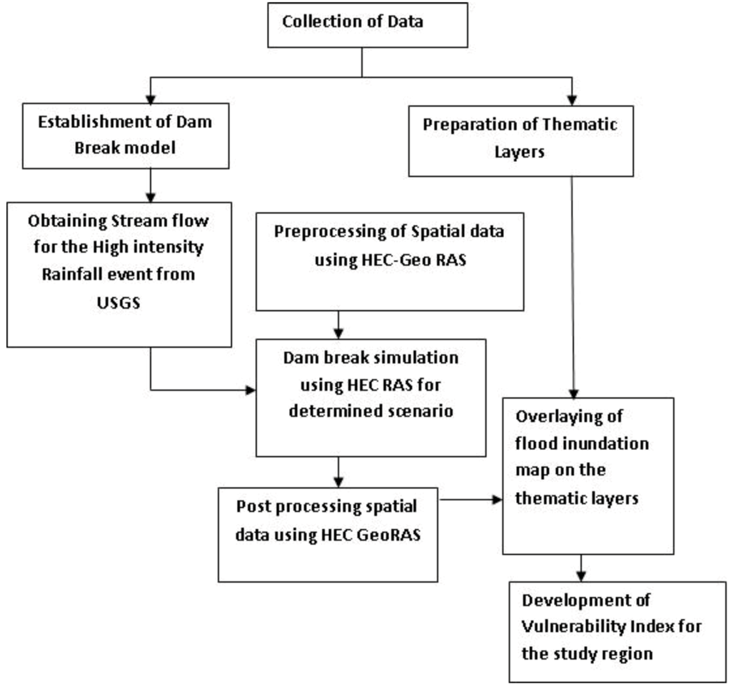
Figure 3.
Processing of data flow.
Figure 3.
Processing of data flow.

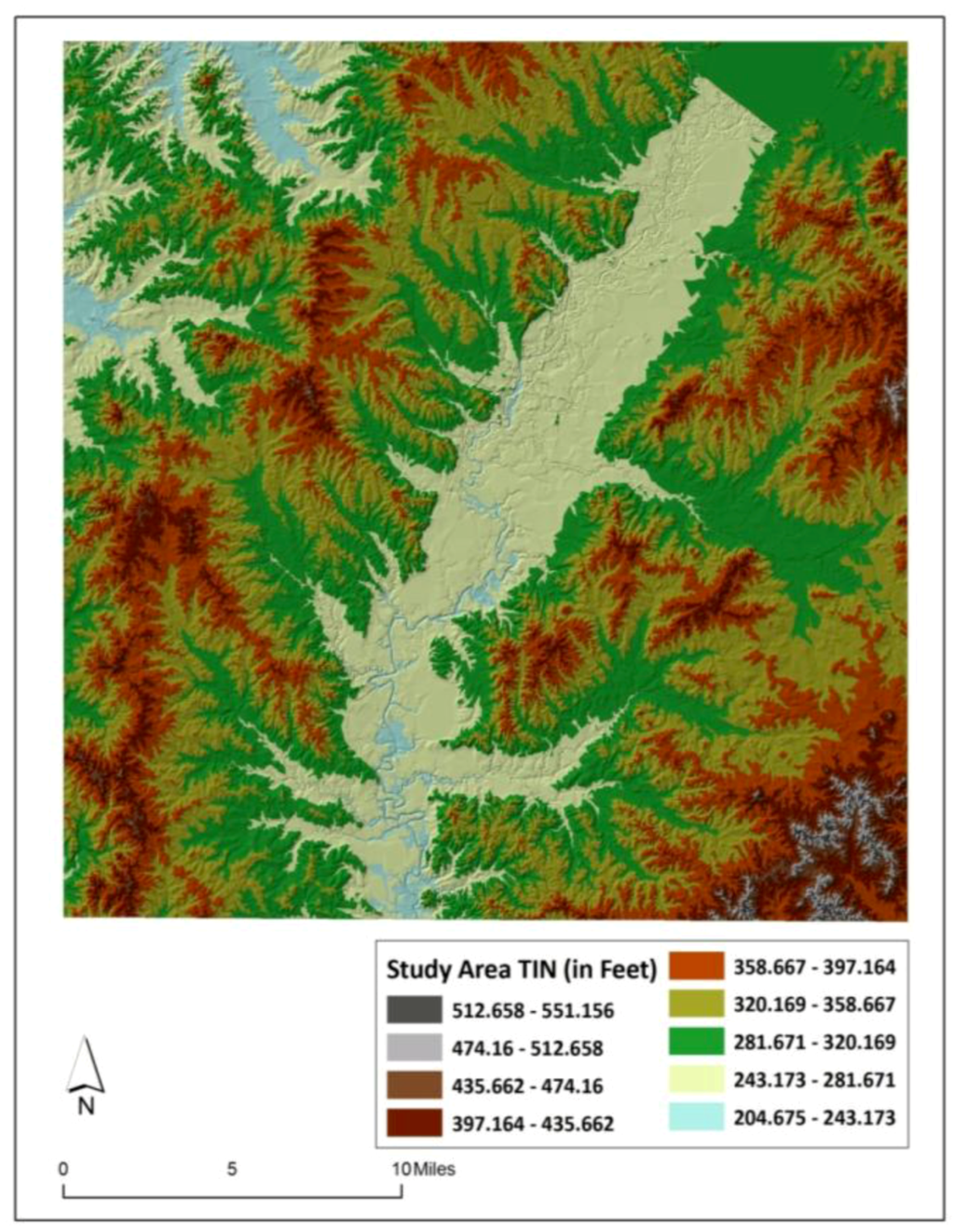
Figure 4.
Triangular Irregular Networks (TIN) of the study region.
Figure 4.
Triangular Irregular Networks (TIN) of the study region.

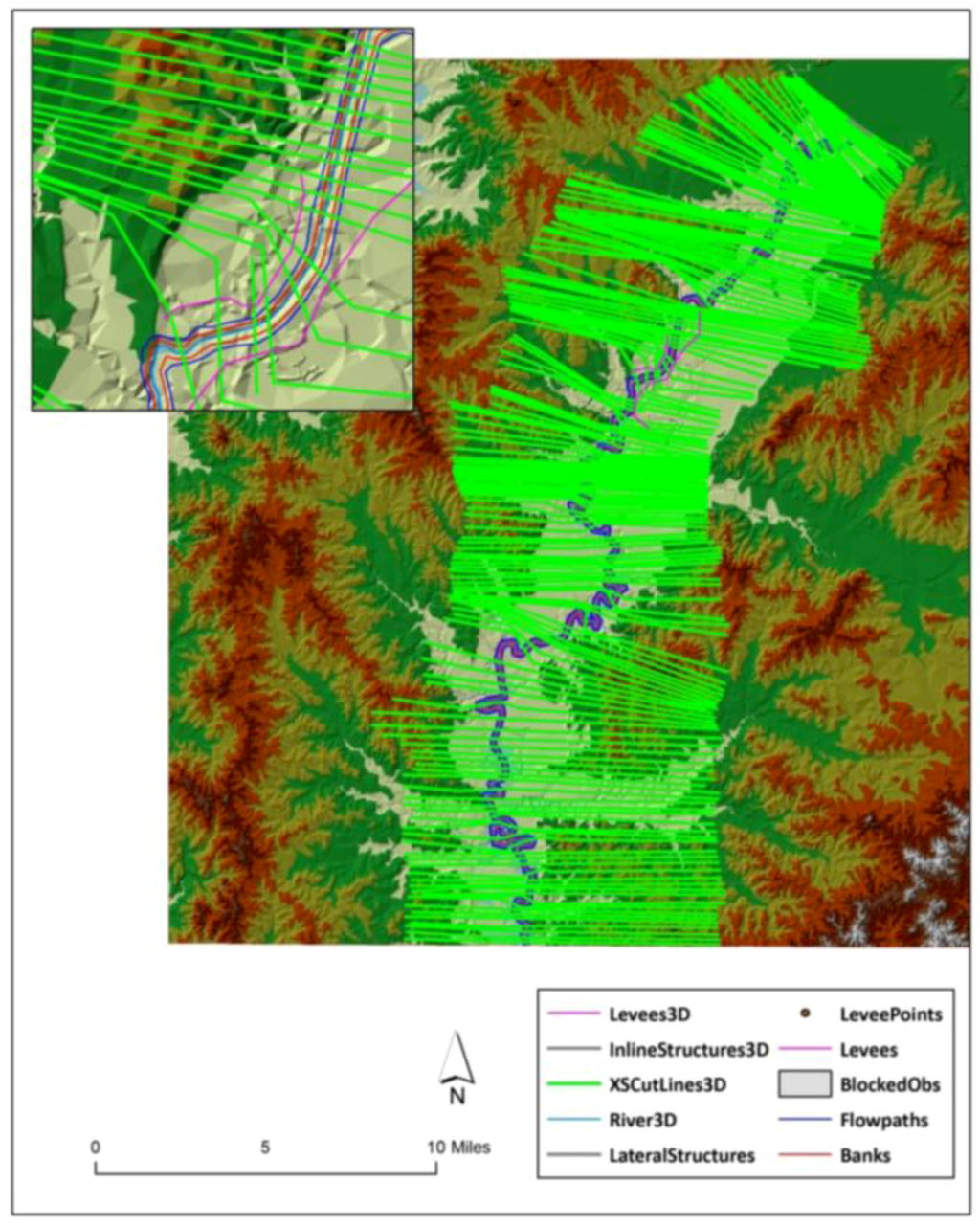
Figure 5.
Preprocessing of geospatial RAS layers.
Figure 5.
Preprocessing of geospatial RAS layers.

2.2. Inundation Risk Level Assessment
Using ArcGIS functionalities, the thematic layers for the study region are mapped for key facilities, historic districts, road network, population and housing units (Figure 6, Figure 7, Figure 8, Figure 9, Figure 10). The data is collected from various sources, such as Census Bureau, Mississippi Automated Resource Information System (MARIS) and City of Jackson. The maps of density of population and housing units are generated by dividing the total population/housing units in each block by the area of that corresponding block. The spatial location of key facilities and transportation routes are downloaded from MARIS and clipped to the study region using data management tools in ArcGIS.
Overlaying of inundation data with the thematic layers of the study region in a geospatial environment not only provided a visual representation of the spatial extent of flood waters, but also facilitated the quantitative assessment of the vulnerability risk of the region towards facing the hazard.
Assessment of the inundation risk hazard on the downstream region due to Ross Barnett reservoir dam failure in an high intensity rainfall event is discussed under (1) hazard identification and (2) vulnerability assessment sections. While the hazard identification involves estimating the spatial extent and depth of the flood waters, vulnerability risk assessment analyzes the impact of inundation on the cultural, socio-economic, transformational and infrastructural networks in the downstream region

Figure 6.
Population at block level in Hinds, Rankin and Madison County, MS.
Figure 6.
Population at block level in Hinds, Rankin and Madison County, MS.
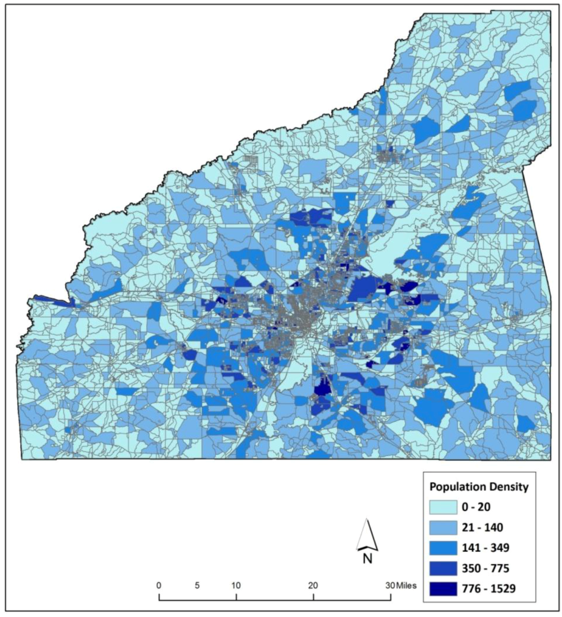

Figure 7.
Housing Units at block level in Hinds, Rankin and Madison County, MS.
Figure 7.
Housing Units at block level in Hinds, Rankin and Madison County, MS.
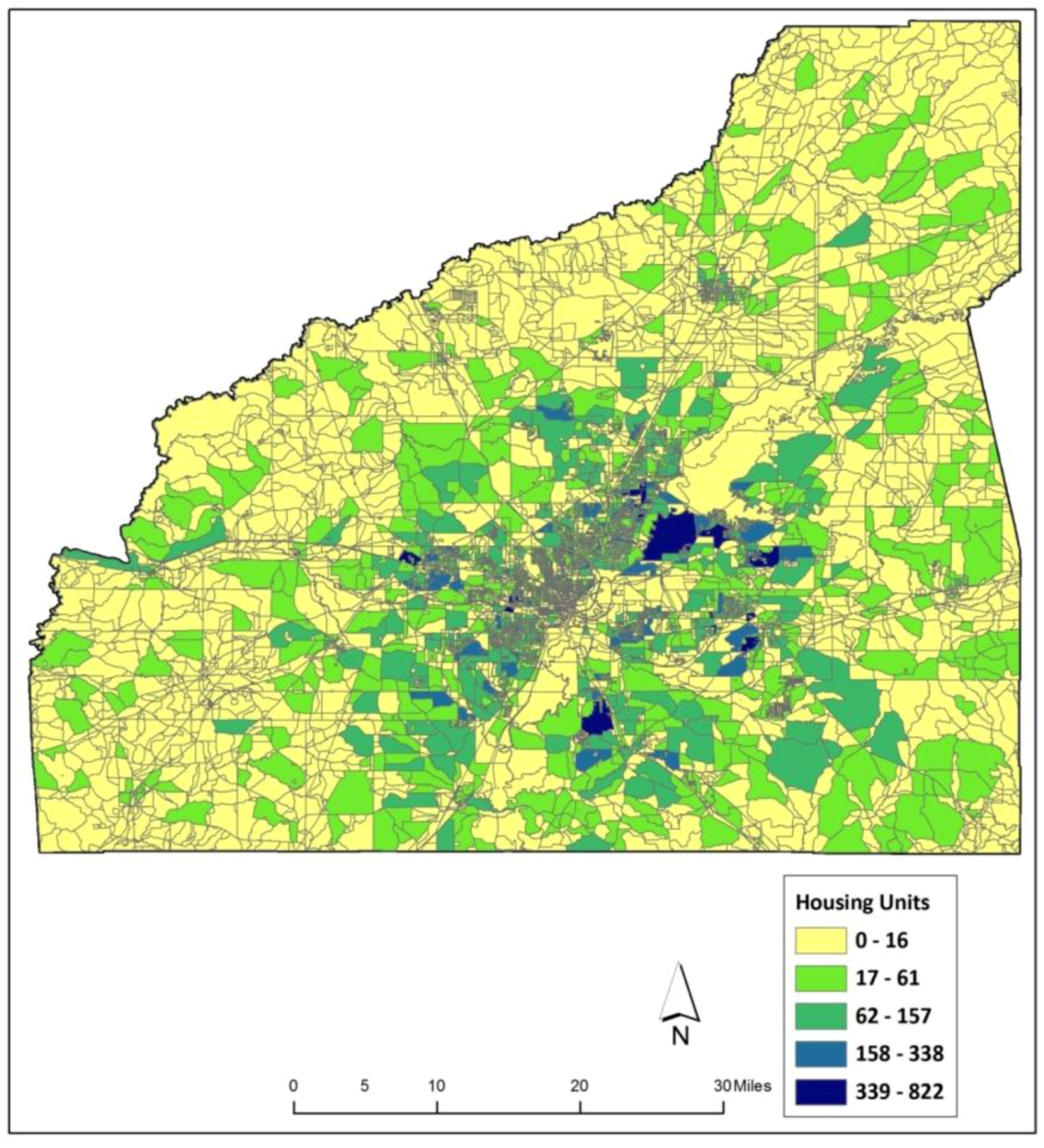
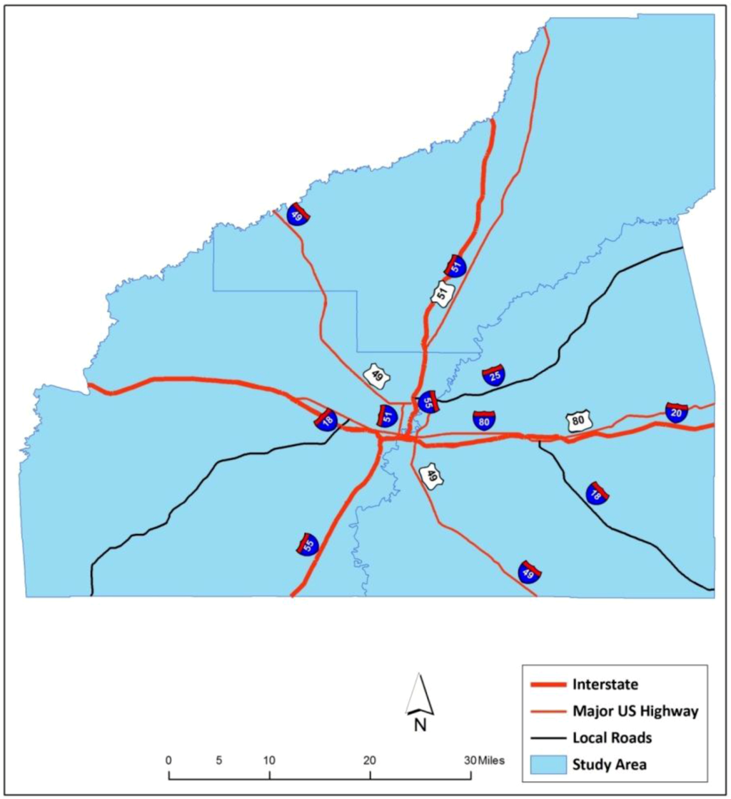
Figure 8.
Major transportation routes through Hinds, Rankin and Madison County, MS.
Figure 8.
Major transportation routes through Hinds, Rankin and Madison County, MS.


Figure 9.
Key facilities in Hinds, Rankin and Madison County, MS.
Figure 9.
Key facilities in Hinds, Rankin and Madison County, MS.
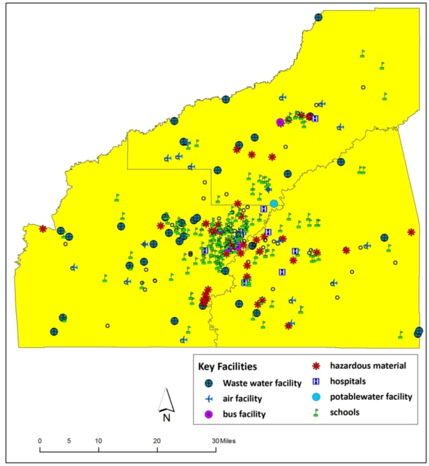

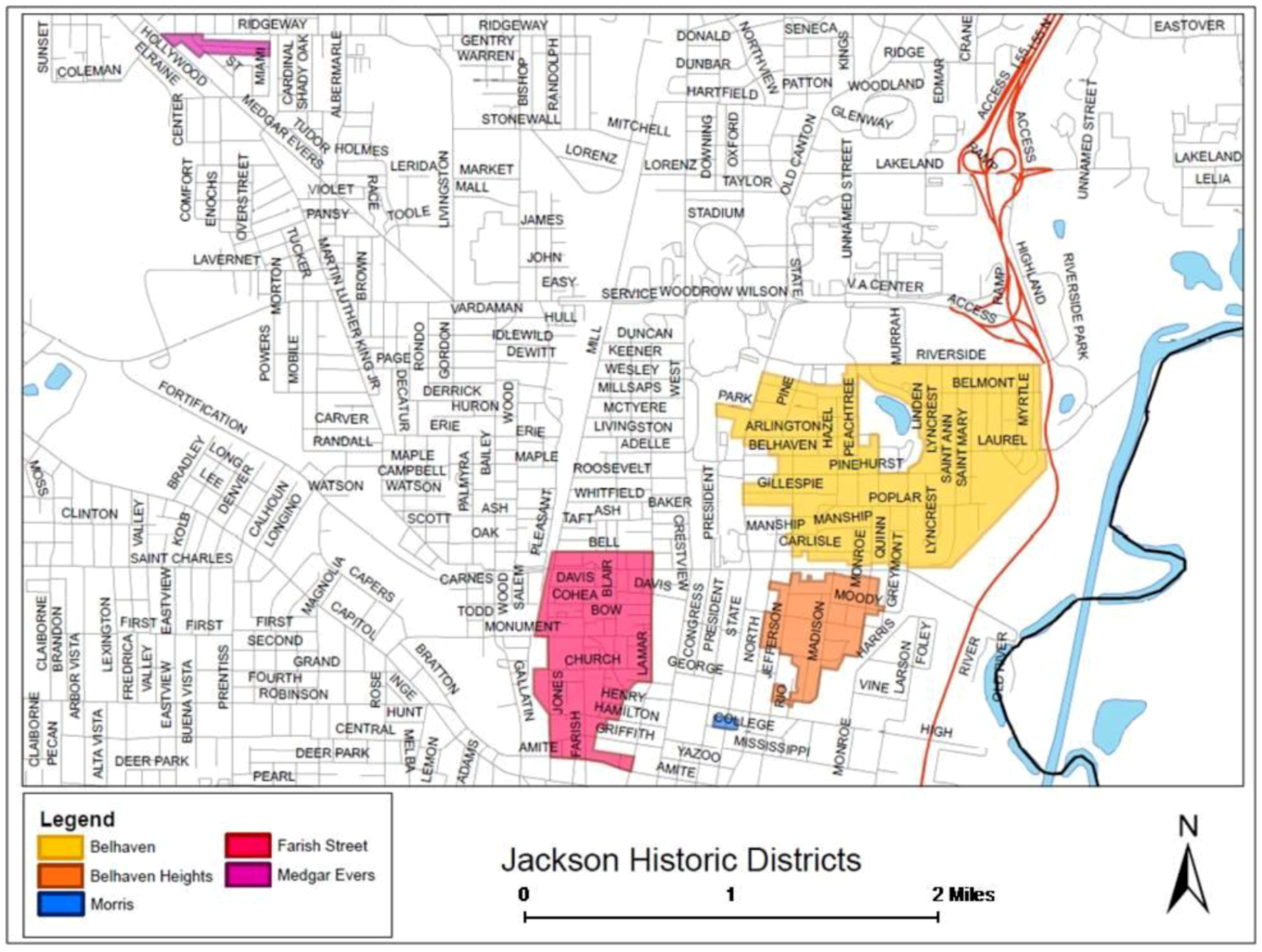
Figure 10.
Historic districts in the City of Jackson (Source: www.jacksonms.gov [27]).
Figure 10.
Historic districts in the City of Jackson (Source: www.jacksonms.gov [27]).
3. Results and Discussion
Integration of the scientifically generated information in the planning process helps in exposing the long-term threats posed by flood hazards. It facilitates the present planning activities to be designed in a futuristic manner and assists towards retaining the social, economical and environmental functionalities viable in the face of hazard. In order to achieve safe and sustainable communities, urban planners should view and understand the physical characteristics of hazard as an important indicator for identifying vulnerable areas [28]. The interaction of the hazard with an urban area can have a potential impact on its cultural, historical, social, infrastructural and economical functionalities. Analyzing the vulnerability of these functionalities in the face of a flood event will not only present an insight about the disturbances that might occur in these inter-related functionalities, but also expose the risk factor upon which the current developmental activities are being planned. The analysis from this vulnerability assessment, as said by Geertman [29], can assist in advancing the inclusive nature of climate change factors in the planning process, thereby strengthening the focus of the sustainable approach in the future developmental activities downstream of the Ross Barnett Reservoir Dam.
As the downstream region (Hinds County) is taking part in the FEMA National Flood Insurance Program (NFIP), all the developmental activities are bound to a 100-year base flood magnitude. With the presence of a high hazard dam in the upstream and with climate change effects in place, planning developmental activities considering a 100-year flood hazard level may not hold good. In this context, the spatial locations of the blocks with potential flood threat are assessed by calculating a vulnerability index from an integrated risk factor obtained from the spatial extent of the identified hazard and the vulnerability risk of the region.
The study discusses the dam break simulation results under two sections: (1) hazard identification and (2) vulnerability assessment. While the hazard identification section discusses the spatial extent and depth of the flood waters, vulnerability assessment is described under the cultural-historical and social-infrastructural (population, housing units, transportation, key facilities) impacts due to inundation. Finally, the study calculates the integrated risk factor and presents the spatial location of high/medium/low vulnerable blocks due to a Ross Barnett Reservoir Dam failure under a high intensity rainfall event in Hinds County.
3.1. Hazard Identification
Hazard identification involves defining the spatial extent and magnitude of a hazard that may be possible for a specific geographical area. For the simulated scenario, the hazard is identified in terms of area of acres inundated and the flood water depth in the downstream region.
3.1.1. Spatial Extent
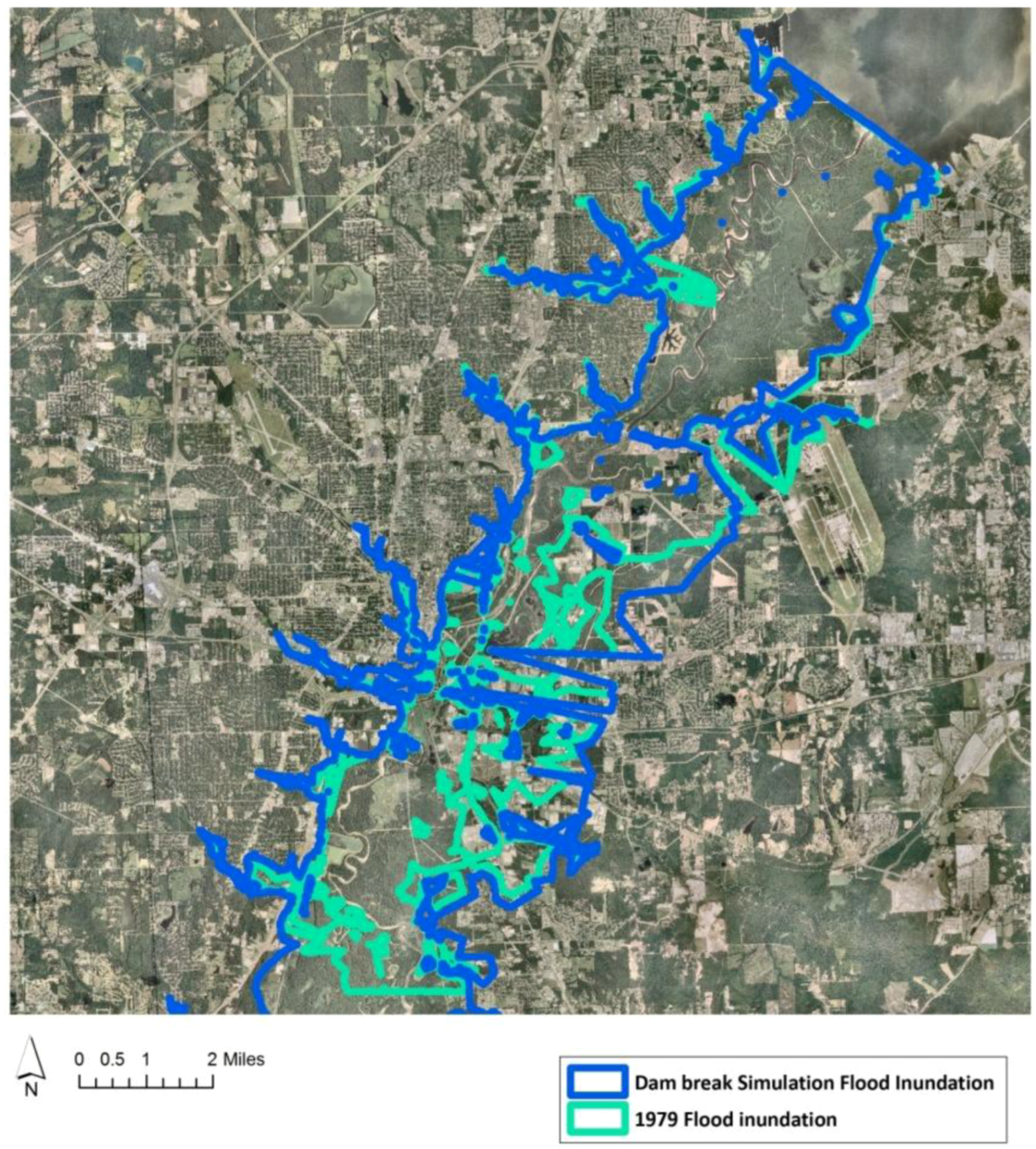
The spatial extent of inundation occurring due to Ross Barnett Reservoir Dam failure continues till the end of Hinds County (Figure 11). Using ArcGIS functionalities, it is estimated that an area of 50,331 acres of land is under inundation. Interestingly, the amount of area inundated by the simulation almost equals the 50,955 acres of spatial extent in the flood waters of the 1979 flood [30]. Correspondingly, through a visual comparison made by overlaying the spatial flood extents of the dam break simulation and 1979 flood waters (obtained from National Oceanic and Atmospheric Administration (NOAA)), the inundation pattern in both the scenarios almost matches and appears to follow the same path (Figure 12). As the 1979 flood is considered as a catastrophic 200-year flood, it can be inferred that the Ross Barnett Reservoir Dam failure under a high intensity rainfall event can cause a flood equivalent to a magnitude of a 200-year flood level.
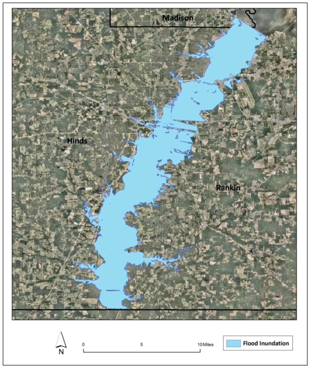
Figure 11.
Spatial extent of inundation downstream of Ross Barnett Reservoir.
Figure 11.
Spatial extent of inundation downstream of Ross Barnett Reservoir.


Figure 12.
Comparison of inundation patterns of dam break simulation and 1979 flood inundation.
Figure 12.
Comparison of inundation patterns of dam break simulation and 1979 flood inundation.
The possibility of a recurrence of the flood threat under the high intensity rainfall event is quite possible. The results reveal alarming information, as the current developmental activities in the downstream counties are bound to a 100-year flood magnitude, while situated under a quite possible 200-year flood threat.
3.1.2. Depth Grids
The depth of the flood waters due to the Ross Barnett Reservoir Dam failure are presented in Figure 13, with range of water depths illustrated (Red–Blue: High–Low).
The maximum depths of the flood waters go up to 45.8 feet for the simulated scenario. The flood water depth at the same location in a 1979 flood situation was measured as 42.5 ft. The flood water depth obtained from dam failure is observed to be more than the 1979 flood scenario. The water depth values of Ross Barnett Reservoir Dam failure in a high intensity rainfall event can be compared to a 1979 flood scenario, leading to almost similar flooding depths. The comparison is done on the assumption that the difference in the depth values are caused due to the calculation of the depth grids from the corresponding DEMs used in their respective simulations.
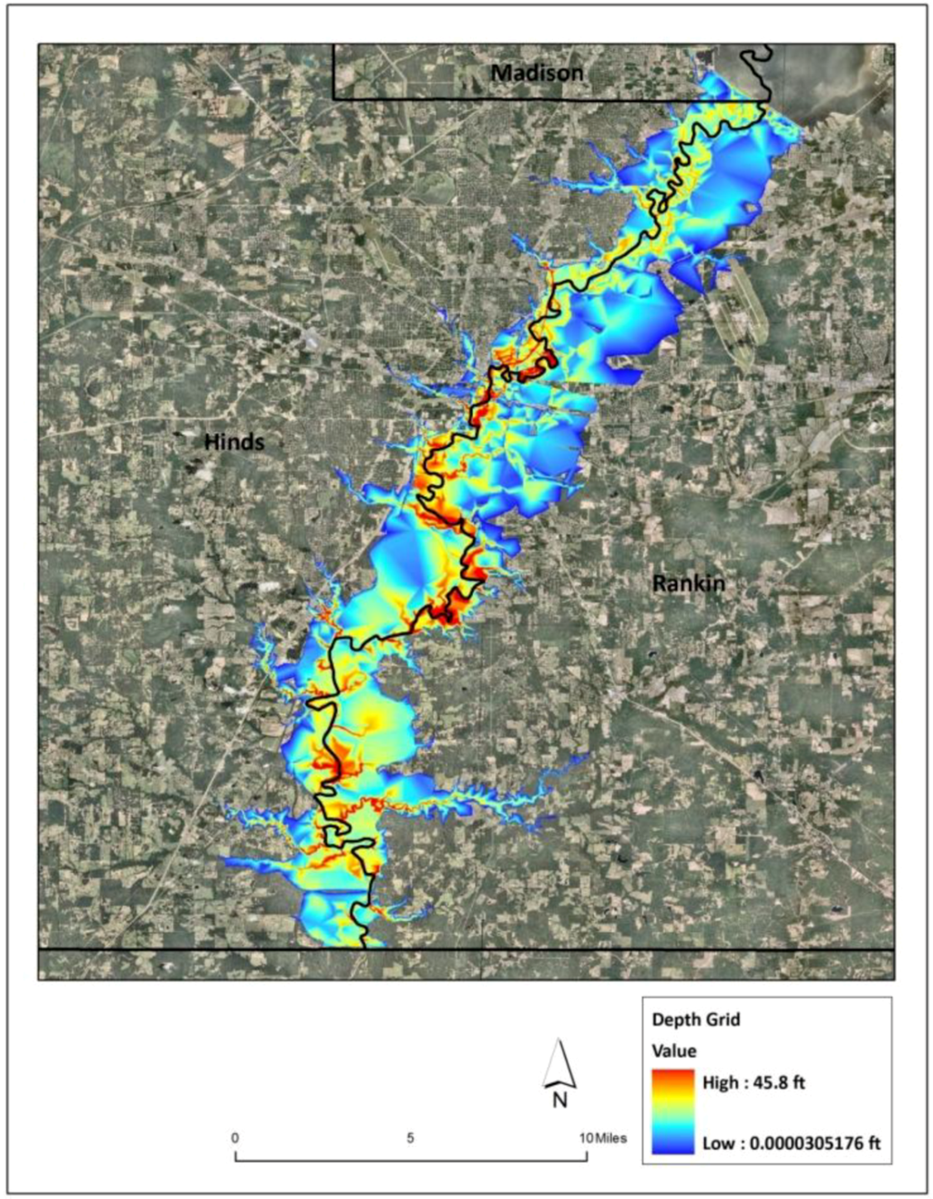
Figure 13.
Depth grid of inundation downstream of Ross Barnett Reservoir.
Figure 13.
Depth grid of inundation downstream of Ross Barnett Reservoir.

3.2. Vulnerability Assessment
Assessing the vulnerability helps in identifying the risk factor and exposing the disturbance that might affect the economical, social/infrastructural and environmental activities of a community. According to a UNEP report (2001), information from vulnerability assessment helps in building flood-resistant communities by reducing or enhancing the coping capacity of the community with the flood hazard by sensibly planning developmental activities. Using ArcGIS functionalities, the study discusses the vulnerability of the downstream region of Ross Barnett Reservoir in the face of its failure (under determined rainfall events) under two factors: (1) impact on cultural and historical values and (2) Impact on social and Infrastructural facilities.
3.2.1. Impact on Cultural and Historical Values
The Mississippi state capital is considered as a cultural hub, with around 700 events taking place every year in its vicinity. The majority of these events are hosted in the downtown region of the City of Jackson at the Fairgrounds and Coliseum. People all across the state and nation are culturally connected to the South’s biggest fair, the Mississippi State Fair, rodeos, trade mart, live stock shows and many more events. Apart from these events, numerous museums that portray the historical and cultural richness of the region (Old Capitol Museum, Oaks House Museum, Municipal Art Gallery, etc.) in downtown Jackson and the Natural Science Museum and the Agricultural Museum on Lake Land Drive are situated in the flood risk zone in the downstream region of the Ross Barnett Reservoir Dam. Visualizing results from the simulation indicate that the cultural functioning of the region gets impacted either directly by flood waters or indirectly through disrupted transportation networks leading to the facility (Figure 14, Figure 15).

Figure 14.
Ross Barnett Reservoir Flood waters at the intersection of Lake Land drive and I-55.
Figure 14.
Ross Barnett Reservoir Flood waters at the intersection of Lake Land drive and I-55.
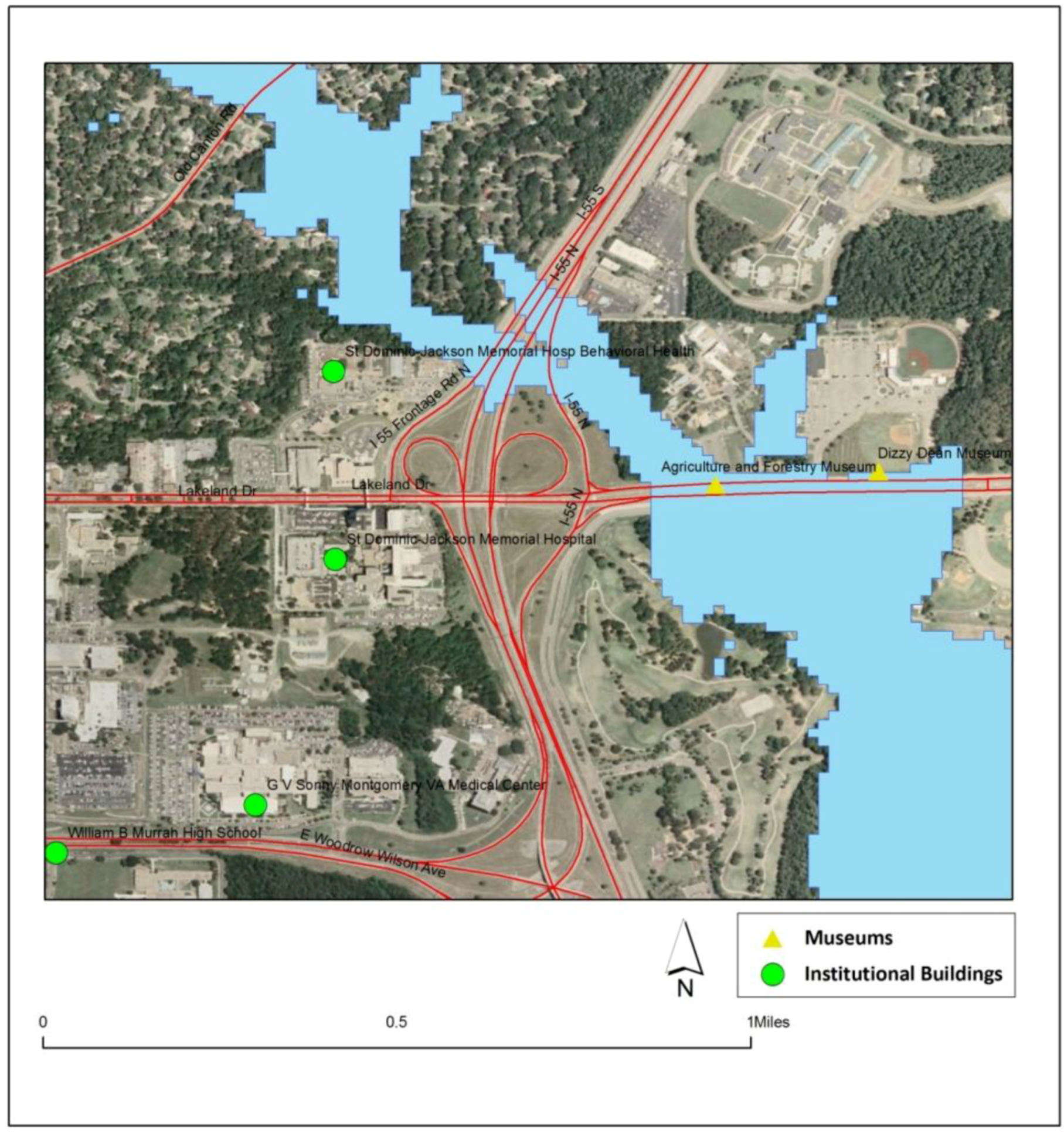
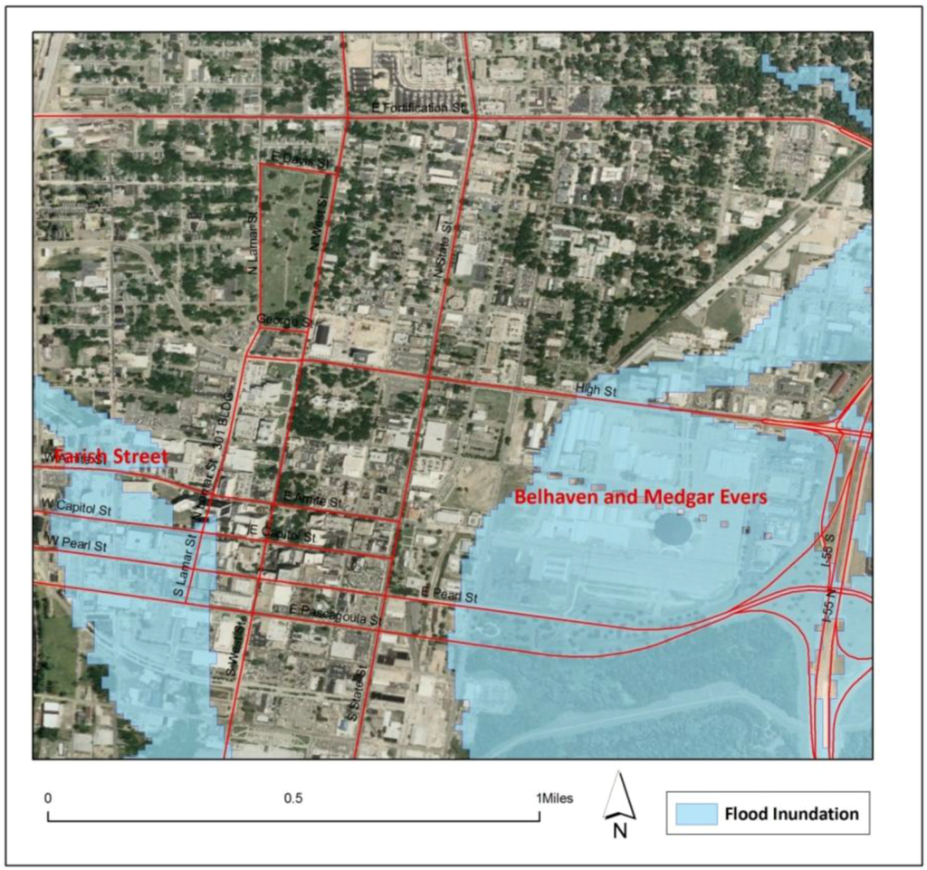
Figure 15.
Inundation of the historic districts in downtown Jackson.
Figure 15.
Inundation of the historic districts in downtown Jackson.

Inundation of the Mississippi Coliseum and Fairgrounds (from I-55 till Jefferson Street under the flood waters) can be seen from Figure 15, above. Hindrances to these events can impact the economic capability of businesses, such as hotels, restaurants and cab services, which depend on cultural events for their survival.
The effort of the department of planning and development to enhance tourism, preserve historic buildings and stabilize neighborhoods has resulted in identifying five historic districts in the City of Jackson, the majority of them situated in the downtown region (Figure 15). Millions of dollars are funded to these projects by local, state and national trust funds in order to support them to retain and stabilize. From the above figures, it can be evident that the Ross Barnett Reservoir Dam failure in a high intensity rainfall event puts the Belhaven, Medgar Evers and Farish Street historic districts at flood risk. The results identify the possible threat under which these areas are situated and, thereby, facilitate the planning authorities to integrate such information, so as to steer the programs to withstand such threats.
3.2.2. Impact on Social and Infrastructural Facilities
Population and Housing Units: Analyzing population and housing units is a vital factor in assessing the vulnerability of a region towards a flood event. Zheng [31] describes social vulnerability, determining the presence of population and housing units, as the key factor in assessing the resistance of any community towards a flood threat. Census block level data was used to estimate the potential number of housing units and population at risk (Figure 16, Figure 17).
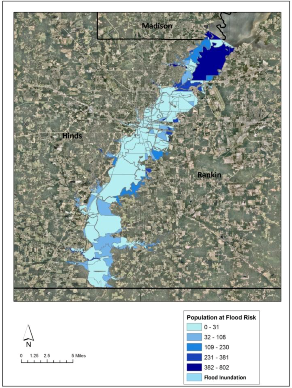
Figure 16.
Population at flood risk downstream of Ross Barnett Reservoir.
Figure 16.
Population at flood risk downstream of Ross Barnett Reservoir.


Figure 17.
Number of housing units at flood risk downstream of Ross Barnett Reservoir.
Figure 17.
Number of housing units at flood risk downstream of Ross Barnett Reservoir.
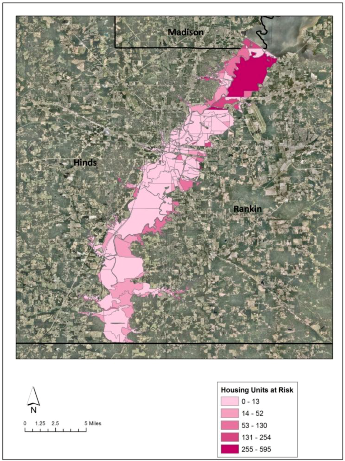
Table 1 shows the statistical numbers of housing units and population likely to be affected by inundation. The impact of Ross Barnett Reservoir Dam failure is majorly borne by Hinds County, as the county bears more than 60% of the population and housing units at flood risk. With the state capital, the City of Jackson, being in Hinds County, the impact of this flood hazard can be cumulative.

Table 1.
Number of population at risk in the downstream and Hinds County region.
| Total Population Affected Downstream | Hinds County Population Affected | Total Inundated in Downstream (Housing Units) | Total Inundated in Hinds County |
|---|---|---|---|
| 34,100 | 21,660 | 16,279 | 10,384 |
Transportation: Disruption in the transportation system by flooding can paralyze the region’s social and economic functionality from a local to regional level. Figure 18, Figure 19 depict the spatial location of the length of inundation on the major highways and interstates running through the downstream region of Ross Barnett Reservoir. Highway 49 and I-55 are the most affected transportation corridors.
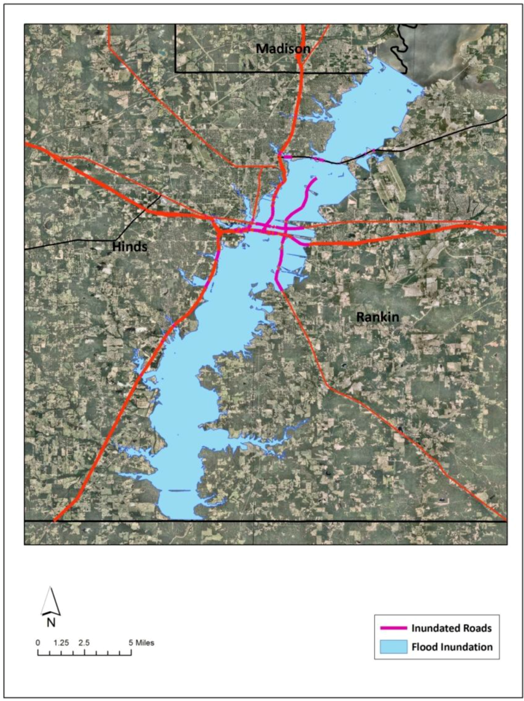
Figure 18.
Spatial location of possible disruptions in the major transportation corridors.
Figure 18.
Spatial location of possible disruptions in the major transportation corridors.


Figure 19.
Depth of the flood waters on Lake Land Drive.
Figure 19.
Depth of the flood waters on Lake Land Drive.
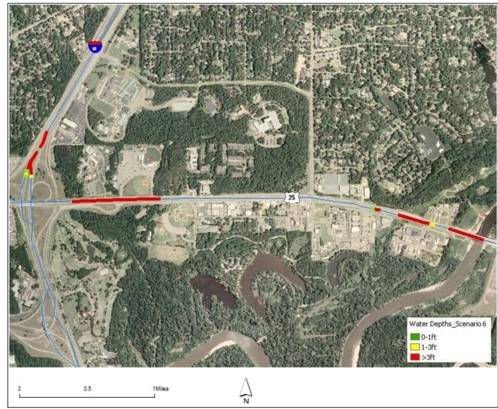
With the depth grid information obtained from HEC-RAS results, the study integrated the information with the road network and identified locations under various ranges of flood water by categorizing the water depths into 0–1 ft, 1–3 ft and >3 ft levels. Figure 16 indicates that these flood water depths on I-55 and Hwy 25 impact accessibility to the major healthcare facilities of the region, namely St. Dominic’s Jackson Memorial Hospital, Mississippi Medical Center, and cultural facilities, such as the Agricultural Museum and the Natural Science Museum, that are located along these major transportation corridors of the region.
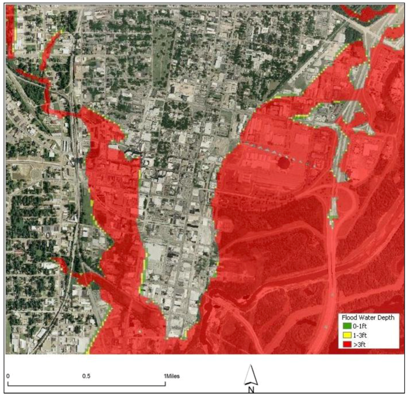
The water depth grids generated by HEC-RAS on I-55 (downtown region) indicate that an inundation of more than 3-ft-deep flood waters can impact the economic functionality of the region, as most of the commercial and administrative functionalities are accomplished from this region (Figure 20).

Figure 20.
Inundation on I-55 near downtown region.
Figure 20.
Inundation on I-55 near downtown region.
Key facilities: Inundation of key facilities impacts the operational efficiency of any region. Simulation results specify that around 33 key facilities get directly affected by the Ross Barnett Reservoir Dam failure under high intensity rainfall event (Figure 21).

Figure 21.
Spatial locations of affected key facilities downstream of Ross Barnett Reservoir.
Figure 21.
Spatial locations of affected key facilities downstream of Ross Barnett Reservoir.
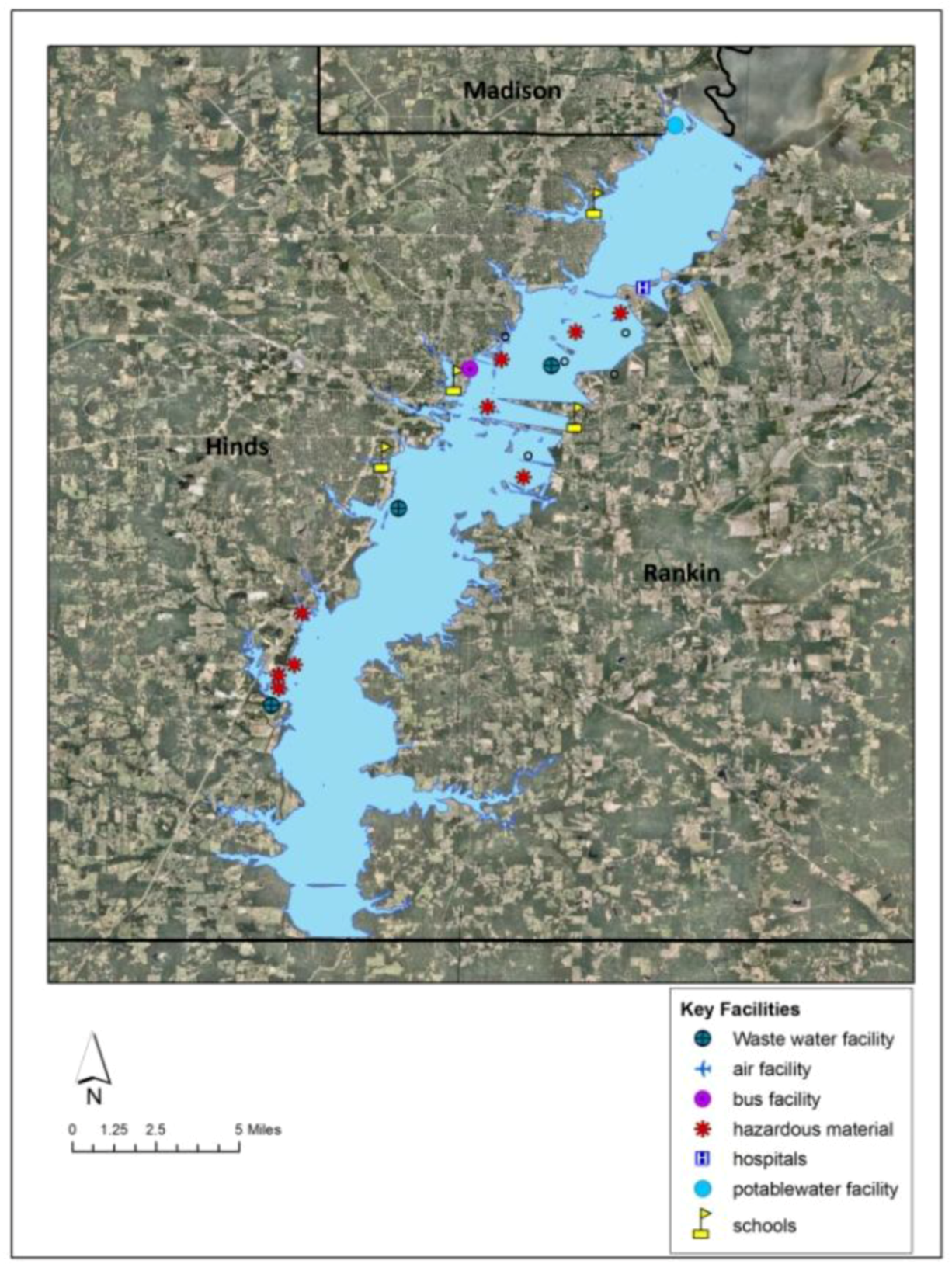
The only potable water facility to the downstream region of Ross Barnett Reservoir Dam will be under flood waters, putting the Hinds County population at risk, with long reaching health impacts (Table 2). The presence of 12 hazardous material plants in the inundation zone further aggravates the risk, as the outbreak/chemical accidents at these plants can pollute the natural resources (such as drinking water, wetlands, etc.), leaving the population and livestock in contaminated environments. The two major transit facilities of the state capital—City of Jackson-Transit Services (on S. President Street) and Jackson Amtrak station on W. Capitol Street—seem to be severely impacted in the simulated event, and shutting down of these may result in paralyzing the economic functionalities of the state capital.
Table 2.
Affected key facilities.
| Key Facilities | Simulation Event |
|---|---|
| Hospitals | 1 |
| Schools | 8 |
| Wastewater Facility | 4 |
| Potable Water Facility | 1 |
| Bus Facility | 1 |
| Communication Facilities | 4 |
| Hazardous Material Plants | 12 |
| Railway Facilities | 2 |
| Total | 33 |
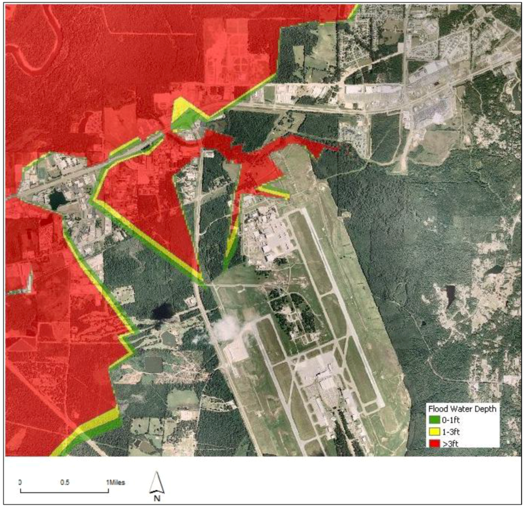
Another major impact the region could experience due to Ross Barnett Reservoir Dam failure is the impact on the only airport serving the state capital region (Jackson International Airport) being surrounded by the flood waters (Figure 22). The global commerce of the state capital with the rest of the world can come to a standstill, which may even have wide consequences in terms of economic expansion of the region.

Figure 22.
Spatial representation of flood waters near Jackson International Airport.
Figure 22.
Spatial representation of flood waters near Jackson International Airport.
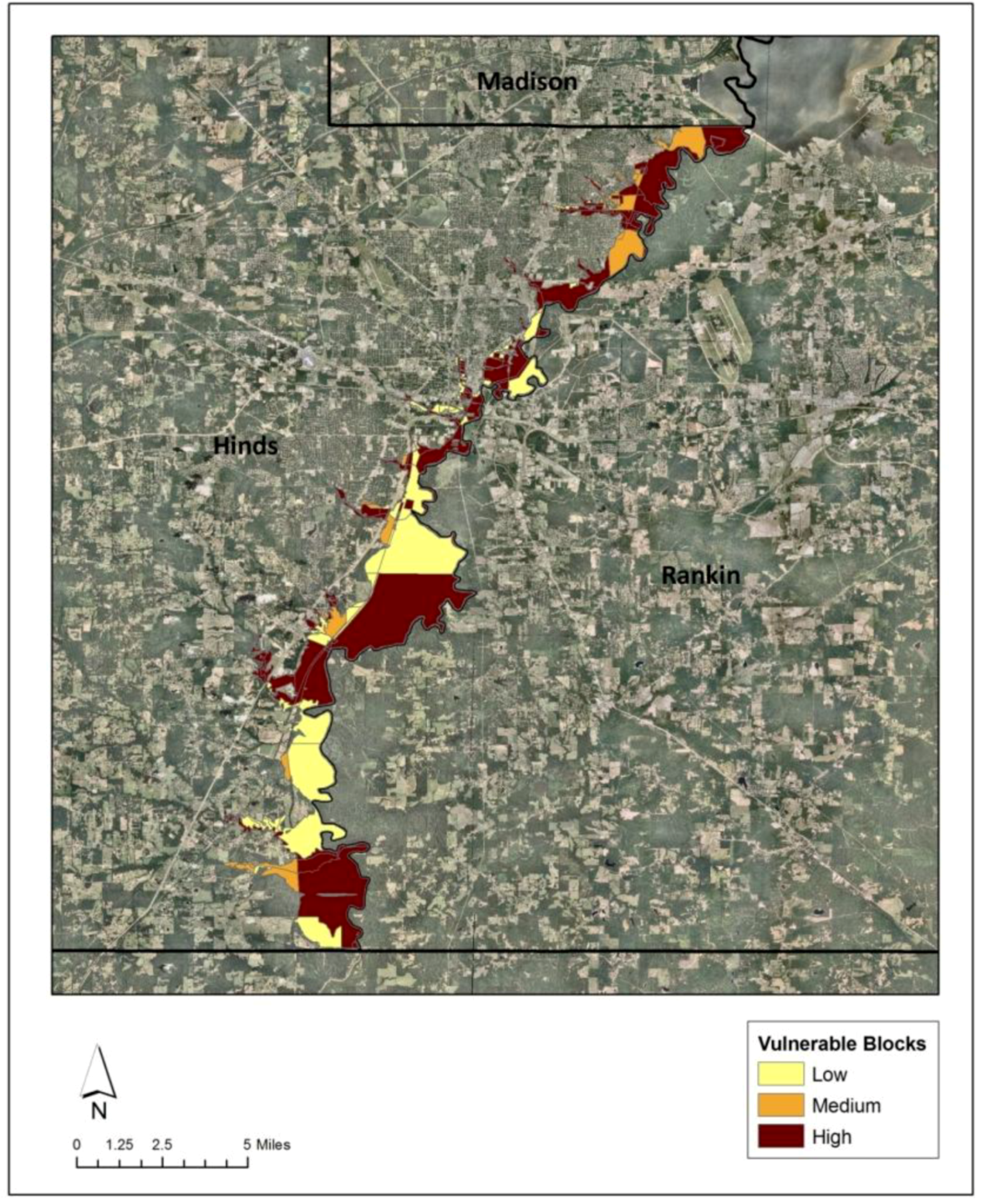
3.2.3. Identification of Highly Vulnerable Blocks in Hinds County
While the discussed vulnerability indicators expose the risks on an individual basis, estimation of a composite index provides an overall risk associated with the region. As described by Timothy [32], this study considered two types of indicators (hazard and social vulnerability indicators) for the estimation of vulnerability index. Under the hazard indicator, the flood hazard map is scaled to a block level, and the maximum flood depth at each block is estimated. These flood depths were then standardized by dividing the flood depth of each block by the maximum flood depth value to create an integrated hazard index that ranges from 0–1.
The presence of at-risk population, housing units and the level of accessibility to critical facilities in a hazard region determines the social vulnerability [32]. In this regard, the study considers four elements to represent the social vulnerability indicators. Density of population and the presence of housing units per each block in the incident area are calculated. The more the density of people and housing units, the greater the risk. The density values are then standardized by dividing each corresponding block value by the maximum density value, so as to create a population and housing units density index that ranges from 0–1. The other two elements that determine the social vulnerability are the accessibility to critical facilities and the functionality of roads that lead to them. Using ArcGIS analysis tools (extract and overlay tools), the shape files of flood waters, location of critical facilities and the transportation network are overlaid, and the critical facilities coming under flood waters and the length of transportation routes affected (in miles) are estimated. Standardization across the blocks are done by dividing each block value with the maximum value to obtain an integrated index that ranges from 0–1.
Once the index values of all the four elements are computed, they are again summed to re-index on a new scale of 0–1 that is assigned to each block. The final vulnerability index across block level is visualized in ArcGIS.
For each block in the study region, the composite index is calculated by taking into consideration the level of flood depth, percentage of inundated roads, number of inundated population and housing units and number of key facilities impacted. Figure 23 illustrates the spatial location of the blocks under various vulnerable zones.

Figure 23.
Levels of vulnerability at a census block level in Hinds County.
Figure 23.
Levels of vulnerability at a census block level in Hinds County.
4. Conclusions
The objective of the study is to assess the potential impact of climate changes on the inundation risk levels in a Ross Barnett Reservoir Dam failure scenario. Most of the previous studies that were done on the impacts of dam failure mainly focused on the hydraulic analysis dimension, analyzing the design failure causes of the dam. Thus, filling the gap, the present study simulates the impact of Ross Barnett Reservoir Dam failure under a high intensity rainfall event on the downstream region and conducted a flood vulnerability index of the blocks.
The 100 year historical rainfall data for the central Mississippi region reveals an increased trend in the intensity of rainfall rates after the 1970s. These events are of high concern, as increased inflow rates may increase the probability of dam failure, leading to higher magnitude flooding events involving multiple consequences. A rainfall event with 16.75 inches/24 h (April 1991) was determined as the high intensity event in the past 100 years. The actual inflow data into the Ross Barnett Reservoir Dam for this rainfall event is collected from the 02486000 USGS (United States Geological Survey) station, which happens to be 16,026 cubic feet per second. As the rainfall event has been experienced by the region in the past, a dam break simulation under this event provides the inundation risks on a typical scale.
The study integrates geospatial technologies with the HEC-RAS model to simulate the dam break flood inundation for the determined rainfall scenario. The integration of geospatial technologies (ArcGIS) with the HEC- RAS 1-D flood simulation model indicates the capability of simulating flood events and spatially depicting the degree of exposure or vulnerability of the region towards a hazard event in terms of inundation extent and depth of water levels.
Simulation of Ross Barnett Reservoir Dam failure under a high intensity rainfall event yielded results with the flood hazard impact (spatial extent and depth grids) extending till the end of Hinds County. The results revealed alarming information indicating the spatial extent and depth grids of flood hazard to equal a 200-year magnitude flood. The numbers of acres coming under flood waters and the maximum depths almost match with the 1979 catastrophic flood. These results bear utmost significance, as the current developmental activities in the downstream counties are bound to 100-year flood magnitude, while situated under a quite possible 200-year flood threat. Vulnerability assessment in this event of a 200-year magnitude flood hazard exposed the possible disturbances that can occur to cultural, economic, transportation and infrastructural amenities, affecting their inter-connected functionalities. Finally, the study developed a composite index to identify the spatial location of vulnerable areas by standardizing individual indicators at a census block level.
The overall objective of the research is to generate information for an improved or enhanced land use planning with respect to flood hazards. By exposing the long-term flood threats, the study assists the planning authorities at the local or county level in identifying vulnerable zones and incorporating the essence of information in its future developmental activities. The basic intention of planning or developmental strategies is to build safer communities by locating developments away from the hazard-prone areas. Identifying vulnerable areas under various possible scenarios plays an important role in the decision-making process. The increase in the vulnerability levels that might occur due to climate change affects downstream of Ross Barnett Reservoir can help the local government to improve the inclusive nature of environmental factors to their focus on achieving sustainable development.
References
- IPCC, Summary for Policymakers. In Climate Change 2007: The Physical Science Basis; Solomon, S.; Qin, D.; Manning, M.; Chen, Z.; Marquis, M.; Averyt, K.B.; Tignor, M.; Miller, H.L. (Eds.) Cambridge University Press: Cambridge, UK/New York, NY, USA, 2007; p. 996.
- Easterling, Williams. Adapting North American agriculture to climate change. Agr. Forest Meteorol. 1996, 80, 1–53. [Google Scholar] [CrossRef]
- United States Environmental Protection Agency, Climate Change and Mississippi; US EPA: Washington, DC, USA, 1998.
- City of Roseville. Dam Failure. Available online: http://www.roseville.ca.us/civica/filebank/blobdload.asp?BlobID=19067 (accessed on 19 November 2012).
- Zhu, N.H.; Turner, E.R.; Doyle, T.; Abdollahi, K. The Potential Consequences of Climate Variability and Change; GCRCC and LSU Graphic Services: Baton Rouge, LA, USA, 2003. [Google Scholar]
- FEMA. Grants Target Mississippi Flood Risks. Available online: http://www.fema.gov/news-release/grants-target-mississippi-flood-risks (accessed on 21 August 2012).
- Idaho National Laboratory, Assessment of Potential Flood Events and Impacts at INL’s Proposed Remote-Handled Low-Level Waste Disposal Facility Sites; US Department of Energy: Idaho Falls, ID, USA, 2010.
- Jami, E.; Scuddkr, M.; Johan, G.; Wilfrid, G. Lessons from a dam failure. J. Sci. 2000, 100, 121–131. [Google Scholar]
- Proactive Measures Needed to Prevent Future Dam Disasters; Association of State Dam Safety Officials: Lexington, KY, USA, 2004.
- US Army Corps of Engineers. Pearl River Watershed Study. 2004. Available online: http://www.mvk.usace.army.mil/offices/pp/projects/prws/background.htm (accessed on 17 August 2012).
- Rutherford, P.H. The Jackson Flood of 1979 a public policy disaster. J. Amer. Plan. Assn. 1982, 48, 219–231. [Google Scholar] [CrossRef]
- MSMEMA, The State of Mississippi Standard Mitigation Plan; MSMEMA: Jackson, MS, USA, 2012.
- Katopodes, N.D. Two dimensional Surges and shocks in open channels. J. Hydraul. Div. 1984, 110, 794–812. [Google Scholar] [CrossRef]
- Hromadka, T.V.; Berenbrock, C.E.; Freckleton, J.R.; Guymon, G.L. A two dimensional dam-break flood plain model. Adv. Water Resour. 1985, 8, 7–14. [Google Scholar] [CrossRef]
- Akbani, A.A. Model for flood propagation on initially dry land. J. Hydraul. Eng. 1988, 114, 689–706. [Google Scholar] [CrossRef]
- Zhao, D.H. Approximate riemann solver in FVM for 2D hydraulic shock wave modeling. J. Hydraul. Eng. 1996, 122, 692–702. [Google Scholar] [CrossRef]
- Sharma, A.K. A Study of Two-Dimensional Flow Propagating from an Opening in the River Dike; Gauhati Univeristy: Gauhati, India, 1999. [Google Scholar]
- Zoppou, C.; Robert, S. Numerical solution of the two dimensional unsteady dam break. Appl. Math. Model 2000, 24, 457–475. [Google Scholar] [CrossRef]
- Davies, T.R.; Scott, B.K. Dam break flood hazard from the Callery River. J. Hydrol. 1997, 36, 1–13. [Google Scholar]
- New Zealand Institute of Water and Atmospheric Research. In A Methodology to Assess the Impacts of Climate Change on Flood Risk in New Zealand; Ministry of Environment: Wellington, New Zealand, 2005.
- Bernardo, R.; Ramos, I. GIS in Flood Risk Management. Available online: http://libraries.maine.edu/Spatial/gisweb/spatdb/egis/eg94056.html (accessed on 11 August 2009).
- Bajwa, H.S.; Tim, U.S. Toward immersive virtual environments for GIS-based Floodplain modeling and Visualization. In Proceedings of 22nd ESRI User Conference, San Diego, TX, USA, 8–12 July 2002.
- Cameron, A.T. Geo Spatial Capabilities of HEC RAS for Model Development and Mapping. In Proceedings of 2nd Joint Federal Interagency Conference, Las Vegas, NV, USA, 27 June–1 July 2010.
- Hicks, F.E.; Peacock, T. Suitability of HEC-RAS for flood forecasting. Can. Water Res. J. 2005, 30, 159–174. [Google Scholar] [CrossRef]
- Cameron, A.T.; Gary, W.; Brunner, P.E. Dam Failure Analysis Using Hec-Ras And Hec-Georas. Available online: http://www.gcmrc.gov/library/reports/physical/Fine_Sed/8thFISC2006/3rdFIHMC/11F_Ackerman.pdf (accessed on 23 September 2008).
- Morris, G.L. Dam Break Flood Hazard Analysis for Quebrada Beatriz Reservoir; Puerto Rico Infrastructure Financing Authority: Caguas, Puerto Rico, 2007. [Google Scholar]
- City of Jackson. Historic Districts. Available online: http://www.jacksonms.gov/assets/planning/historic%20districts.pdf (accessed on 24 August, 2009).
- Burby, R.J. Cooperating with Nature: Confronting Natural Hazards with Land Use Planning for Sustainable Communities; Joseph Henry/National Academy Press: Washington, DC, USA, 1998. [Google Scholar]
- Geertman, S.; Stillwell, J. Planning Support Systems: An Introduction. In Planning Support Systems in Practice; Springer: Berlin, Germany, 2003; pp. 25–55. [Google Scholar]
- Yerramilli, S. A hybrid approach of integrating HEC-RAS and GIS towards the identification and assessment of flood risk vulnerability in the city of Jackson, MS. Am. J. Geogr. Inform. Syst. 2012, 1, 7–16. [Google Scholar]
- Zheng, N.; Takara, K.; Tachikawa, Y.; Kozan, O. Analysis of vulnerability to flood hazard based on land use and population distribution in the Huaihe River basin, China. Ann. Disaster Prev. Restor. 2008, 20, 83–91. [Google Scholar]
- Timothy, C.W. Vulnerability to environmental hazards in the Ciudad Juárez (Mexico)–El Paso (USA) metropolis: A model for spatial risk assessment in transnational context. Appl. Geogr. 2009, 29, 448–461. [Google Scholar] [CrossRef]
© 2013 by the authors; licensee MDPI, Basel, Switzerland. This article is an open access article distributed under the terms and conditions of the Creative Commons Attribution license (http://creativecommons.org/licenses/by/3.0/).