

Secant Cylinders Are Evil—A Case Study on the Standard Lines of the Universal Transverse Mercator and Universal Polar Stereographic Projections

Abstract
1. Introduction
2. Materials and Methods
3. Results
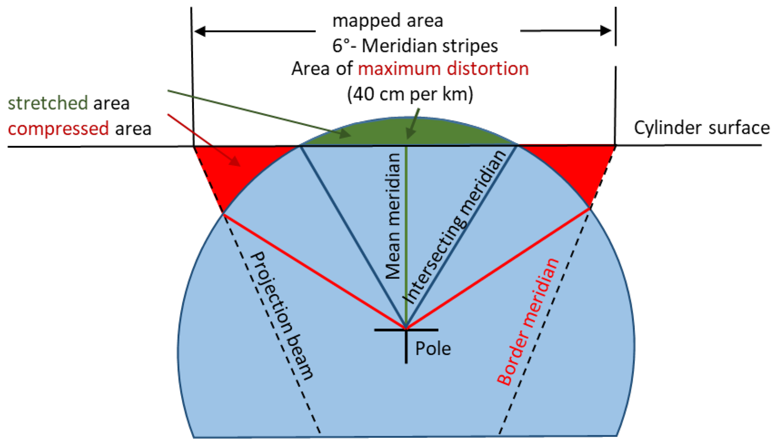
3.1. The UTM Projection with a Secant Cylinder
3.2. The UTM Projection with Exact Formulae
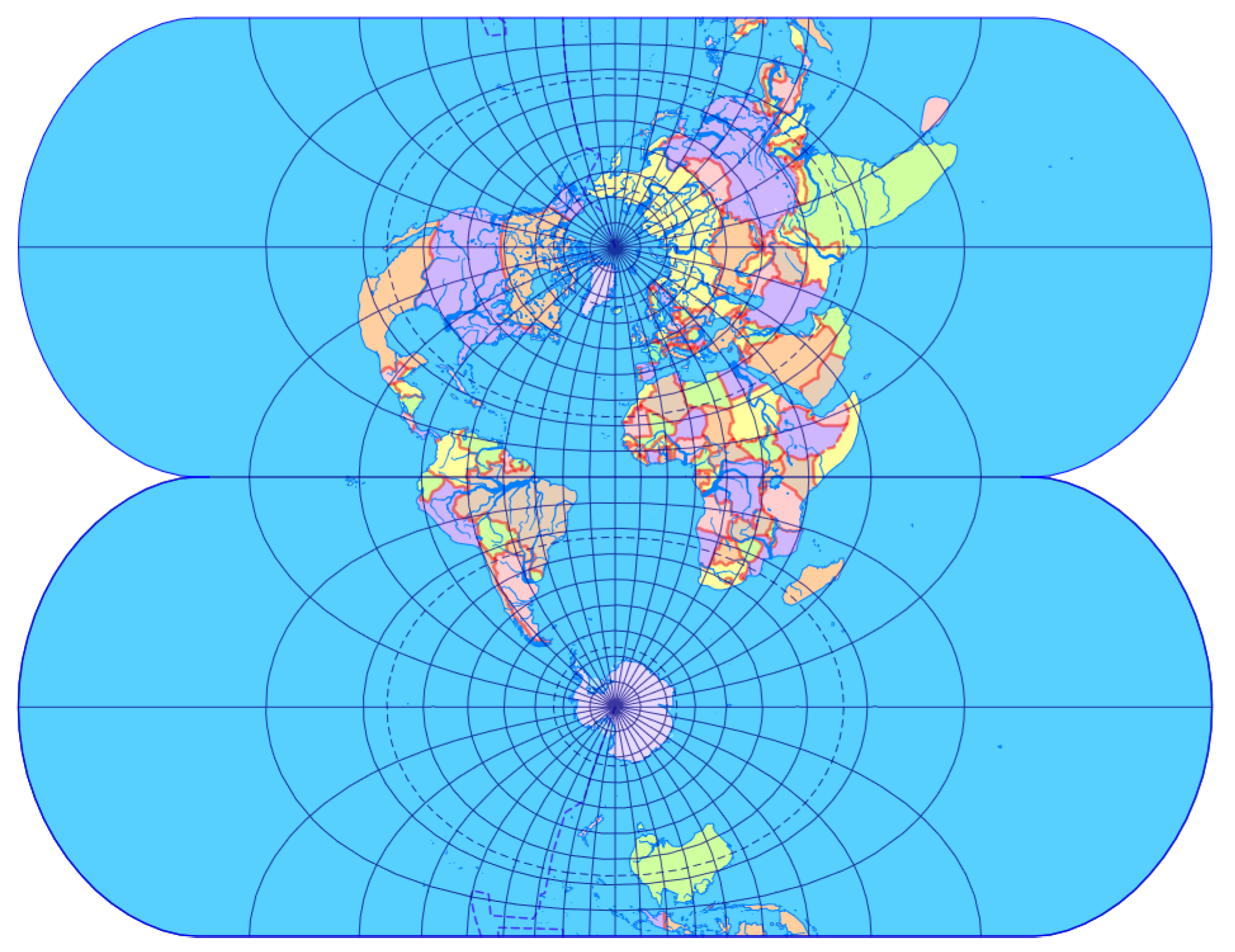
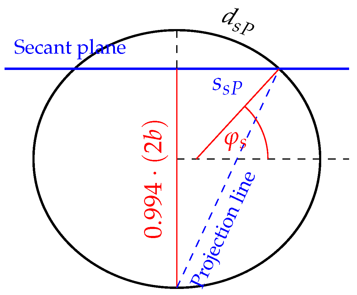
3.3. The UPS Projection Based on a Secant Plane
3.4. The UPS Projection with Exact Formulae
4. Discussion
- If one transforms a perspective map projection from tangent placement to secant placement, it suffers only a uniform scaling. Thus, all secant map projections are merely downscaled projections (so we have a kind of justification to regard downscaled non-perspective map projections as secant).
- Standard lines and secant lines always (or at least usually) coincide (otherwise we have no hint where to pick conceptual secant lines of non-perspective projections).
- UTM and UPS are either perspective or their distortion pattern can be explained by the geometry of a secant surface.
- The image of the UTM projection can be easily rolled to form a cylinder.
5. Conclusions
Supplementary Materials
Funding
Data Availability Statement
Conflicts of Interest
References
- Lapaine, M. Standard Parallel and Secant Parallel in Azimuthal Projections. Kartogr. Geoinformacije 2017, 16, 72–88. Available online: http://kig.kartografija.hr/index.php/kig/article/view/783/1458 (accessed on 8 January 2024).
- Lapaine, M.; Frančula, N. Map Projections Classification. Geographies 2022, 2, 274–285. [Google Scholar] [CrossRef]
- Hager, J.W.; Fry, L.L.; Jacks, S.S.; Hill, D.R. Datums, Ellipsoids, Grids, and Grid Reference Systems; Technical Report TM8358.1; Defense Mapping Agency Hydrographic/Topographic Center: Washington, DC, USA, 1990; Available online: https://apps.dtic.mil/sti/citations/ADA247651 (accessed on 8 January 2024).
- Hager, J.W.; Behensky, J.F.; Drew, B.W. The Universal Grids: Universal Transverse Mercator (UTM) and Universal Polar Stereographic (UPS); Technical Report TM8358.2; Defense Mapping Agency Hydrographic/Topographic Center: Washington, DC, USA, 1989; Available online: https://apps.dtic.mil/sti/citations/ADA266497 (accessed on 8 January 2024).
- GWG World Geodetic System and Geomatics Focus Group. The Universal Grids and the Transverse Mercator and Polar Stereographic Map Projections; Technical Report NGA.SIG.0012; National Geospatial-Intelligence Agency (NGA): Springfield, VA, USA, 2014; Available online: https://nsgreg.nga.mil/doc/view?i=4056 (accessed on 8 January 2024).
- GWG World Geodetic System and Geomatics Focus Group. Universal Grids and Grid Reference Systems; Technical Report NGA.STND.0037; National Geospatial-Intelligence Agency (NGA): Springfield, VA, USA, 2014; Available online: https://nsgreg.nga.mil/doc/view?i=4057 (accessed on 8 January 2024).
- Hey, A.; Bill, R. Tutorial: Map Projections and Coordinate Reference Systems. Universität Rostock, 2019. Available online: https://learn.opengeoedu.de/tutorials/OGE-Tutorial_KNE_Koordinaten-en.pdf (accessed on 8 January 2024).
- Buchroithner, M.F.; Pfahlbusch, R. Geodetic grids in authoritative maps—New findings about the origin of the UTM Grid. Cartogr. Geogr. Inf. Sci. 2017, 44, 186–200. [Google Scholar] [CrossRef]
- Usery, E.L.; Finn, M.P.; Mugnier, C.J. Coordinate Systems and Map Projections. In Manual of Geographic Information Systems; ASPRS Publications: Washington DC, USA, 2009; Chapter 8; pp. 87–112. [Google Scholar]
- Yu, W.; Chen, S.; Zhang, S. Implement of Overhauser magnetometer coordinate transformation software. IOP Conf. Ser. Mater. Sci. Eng. 2019, 563, 052060. [Google Scholar] [CrossRef]
- Dennis, M.L. Ground Truth: Low Distortion Map Projections for Engineering, Surveying, and GIS. In Pipelines 2016; American Society of Civil Engineers: Reston, VA, USA, 2016; pp. 857–869. [Google Scholar] [CrossRef]
- Kraak, M.J.; Roth, R.E.; Ricker, B.; Kagawa, A.; Sourd, G.L. Mapping for a Sustainable World; The United Nations: New York, NY, USA, 2021; Available online: https://www.un.org/geospatial/sites/www.un.org.geospatial/files/MappingforaSustainableWorld20210124.pdf (accessed on 8 January 2024).
- Snyder, J.P. Flattening the Earth: Two Thousand Years of Map Projections; The University of Chicago Press: Chicago, IL, USA, 1993. [Google Scholar]
- Heitzler, M.; Bär, H.R.; Schenkel, R.; Hurni, L. The Light Source Metaphor Revisited—Bringing an Old Concept for Teaching Map Projections to the Modern Web. ISPRS Int. J. -Geo-Inf. 2019, 8, 162. [Google Scholar] [CrossRef]
- Lapaine, M. Gall Stereographic Projection and its Generalization. Geod. List. 2023, 77, 1–10. Available online: https://hgd1952.hr/images/GL/GL_1_2023_www.pdf (accessed on 8 January 2024).
- Lapaine, M. Conic Projections with Three or More Standard Parallels. Proc. ICA 2021, 4, 64. [Google Scholar] [CrossRef]
- Tissot, N.A. Mémoire sur la repréSentation des Surfaces et les Projections des Cartes Géographiques; Gauthiers-Villars: Paris, France, 1881. [Google Scholar]
- Lee, L.P. Conformal Projections Based on Elliptic Functions; York University: Toronto, UK, 1976. [Google Scholar]
- Ludwig, K. Die der transversalen Mercatorkarte der Kugel entsprechende Abbildung des Rotationsellipsoids. J. Die Reine Angew. Math. 1943, 185, 193–230. [Google Scholar] [CrossRef]
- Snyder, J.P. Map Projections—A Working Manual; US Government Printing Office: Washington, DC, USA, 1987; Volume 1395. [CrossRef]
- Karney, C.F.F. Transverse Mercator with an accuracy of a few nanometers. J. Geod. 2011, 85, 475–485. [Google Scholar] [CrossRef]
- Smith, W.H.F. Direct conversion of latitude and height from one ellipsoid to another. J. Geod. 2022, 96, 36. [Google Scholar] [CrossRef]
- Osborne, P. The Mercator Projections; Technical Report; University of Edinburgh: Edinburgh, UK, 2013. [Google Scholar] [CrossRef]
- Wray, T. The Seven Aspects of a General Map Projection; York University: Toronto, ON, Canada, 1974. [Google Scholar]
- Mugnier, C.J. Grids & Datums: România. Photogramm. Eng. Remote Sens. 2001, 67, 545–548. Available online: https://www.asprs.org/wp-content/uploads/2012/05/05-2001-romania.pdf (accessed on 8 January 2024).
- Braun, C. Ueber zwei neue geographische Entwurfsarten. Wochenschr. Astron. Meteorol. Geogr. 1867, 11, 269–272. [Google Scholar]

Disclaimer/Publisher’s Note: The statements, opinions and data contained in all publications are solely those of the individual author(s) and contributor(s) and not of MDPI and/or the editor(s). MDPI and/or the editor(s) disclaim responsibility for any injury to people or property resulting from any ideas, methods, instructions or products referred to in the content. |
© 2024 by the author. Licensee MDPI, Basel, Switzerland. This article is an open access article distributed under the terms and conditions of the Creative Commons Attribution (CC BY) license (https://creativecommons.org/licenses/by/4.0/).
Share and Cite
Kerkovits, K. Secant Cylinders Are Evil—A Case Study on the Standard Lines of the Universal Transverse Mercator and Universal Polar Stereographic Projections. ISPRS Int. J. Geo-Inf. 2024, 13, 56. https://doi.org/10.3390/ijgi13020056
Kerkovits K. Secant Cylinders Are Evil—A Case Study on the Standard Lines of the Universal Transverse Mercator and Universal Polar Stereographic Projections. ISPRS International Journal of Geo-Information. 2024; 13(2):56. https://doi.org/10.3390/ijgi13020056
Chicago/Turabian StyleKerkovits, Krisztián. 2024. "Secant Cylinders Are Evil—A Case Study on the Standard Lines of the Universal Transverse Mercator and Universal Polar Stereographic Projections" ISPRS International Journal of Geo-Information 13, no. 2: 56. https://doi.org/10.3390/ijgi13020056
APA StyleKerkovits, K. (2024). Secant Cylinders Are Evil—A Case Study on the Standard Lines of the Universal Transverse Mercator and Universal Polar Stereographic Projections. ISPRS International Journal of Geo-Information, 13(2), 56. https://doi.org/10.3390/ijgi13020056