
Evaluation and Scale Forecast of Underground Space Resources of Historical and Cultural Cities in China

 , ,
, ,
Abstract
:1. Introduction
2. Literature Review
2.1. Current Research
2.2. Trend of Research
- (1)
- The research of USR needs to bridge quantitative methods with a qualitative approach.
- (2)
- The USR attempt to keep alive the idea of necessary continuity with history and culture.
- (3)
- The rational and systematic indicators of USR need to consider complex cross-bedding.
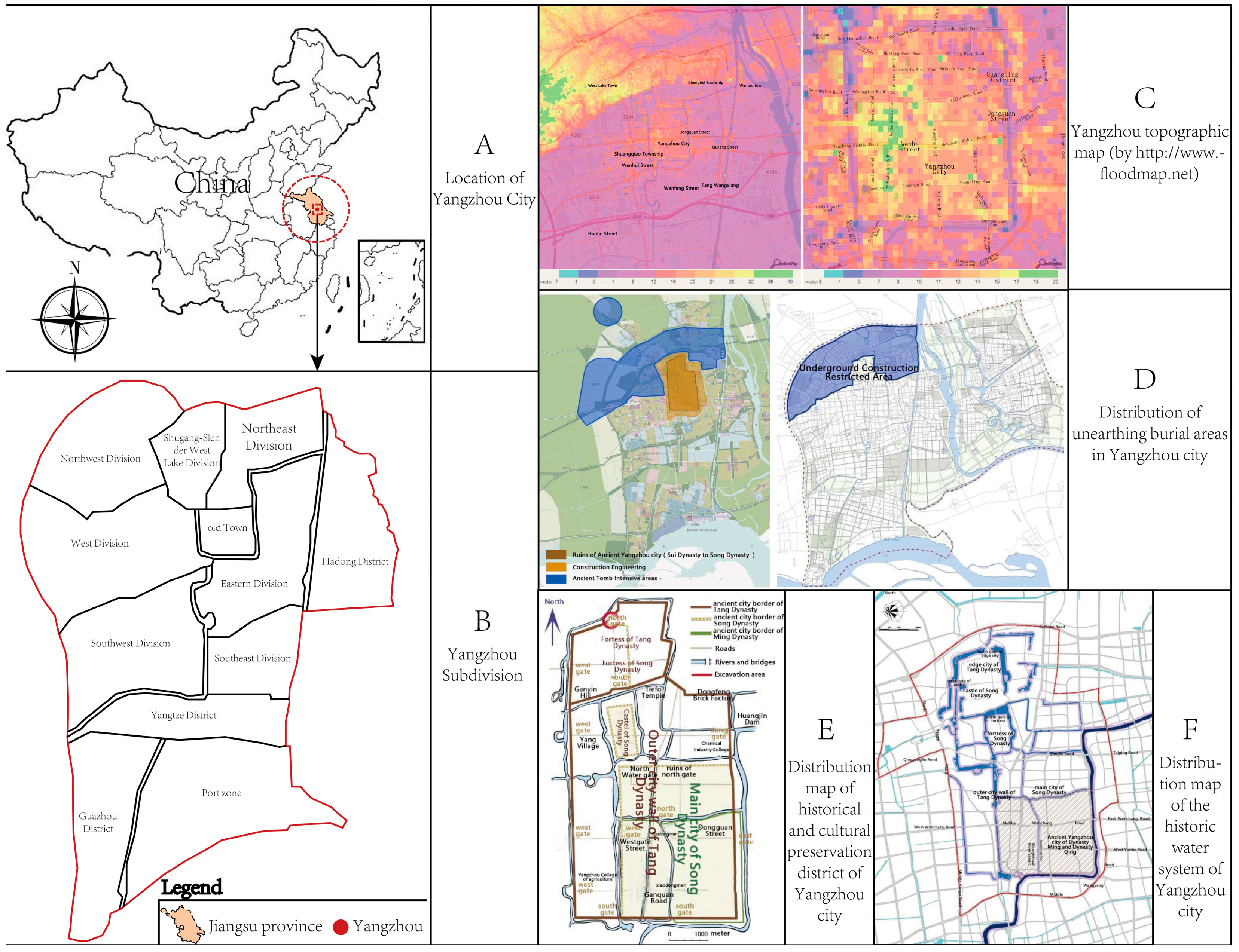
3. Study Area and Data
3.1. Study Area
3.2. Data Collection
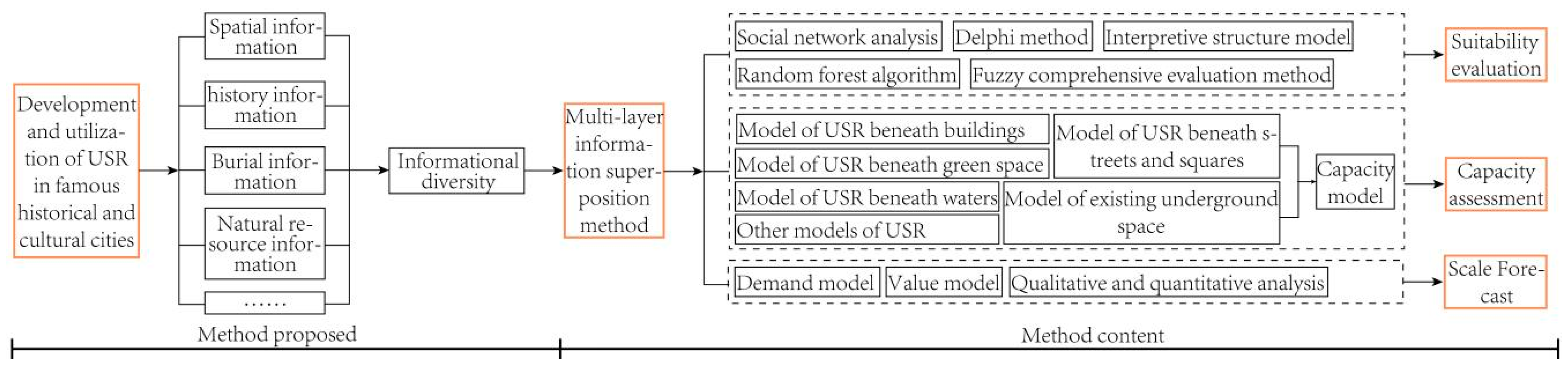
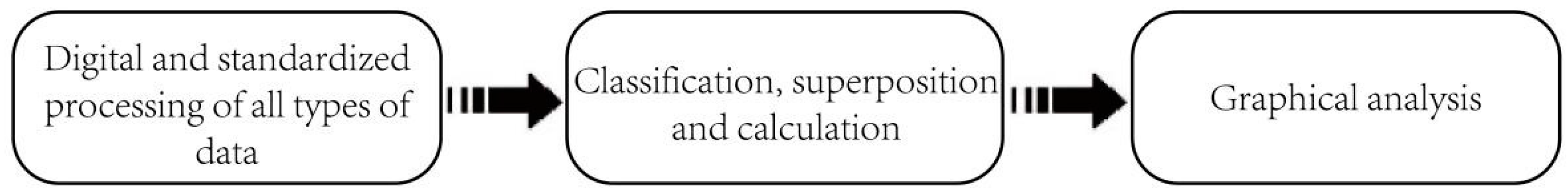
4. Multi-Layer Information Superposition Method
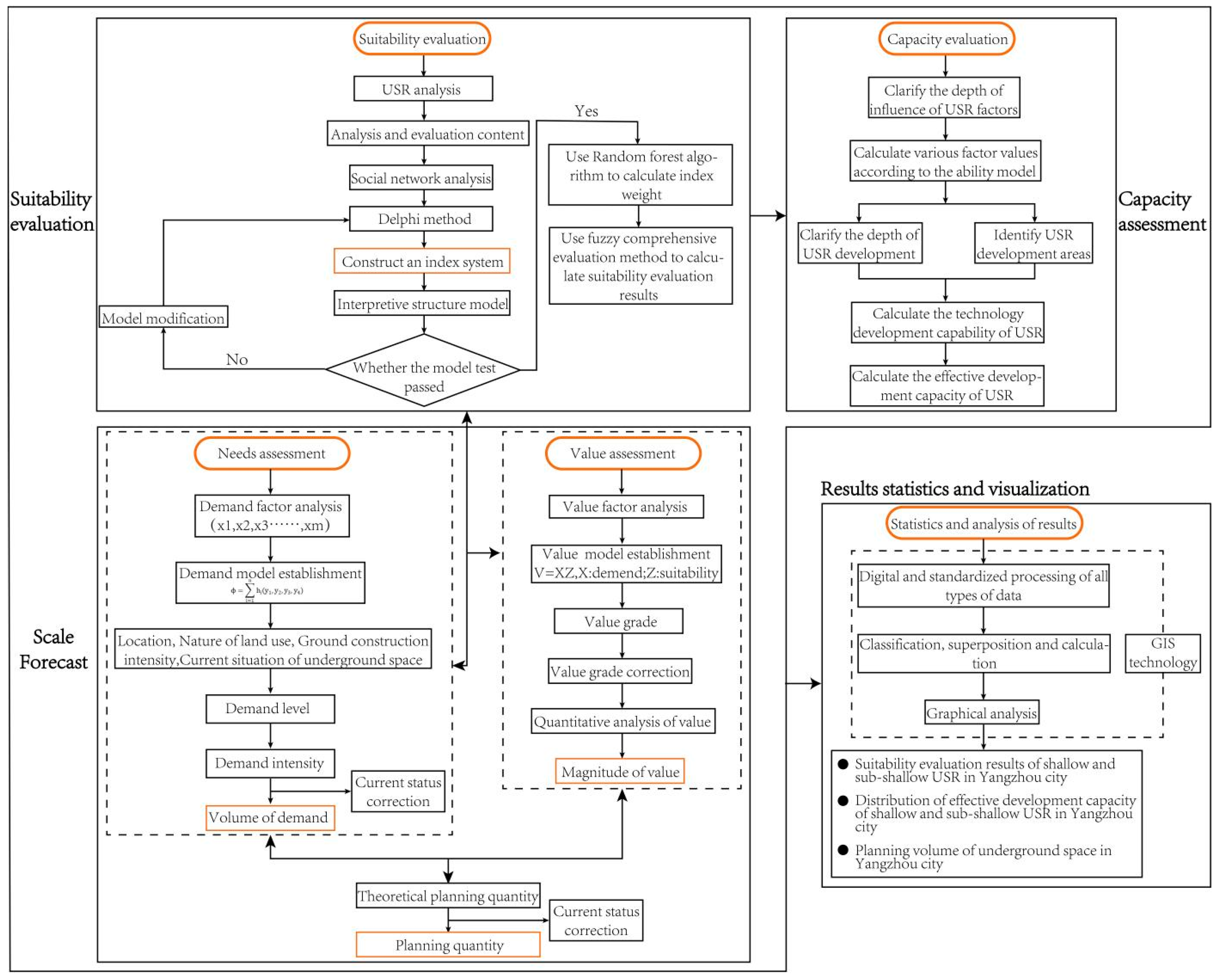
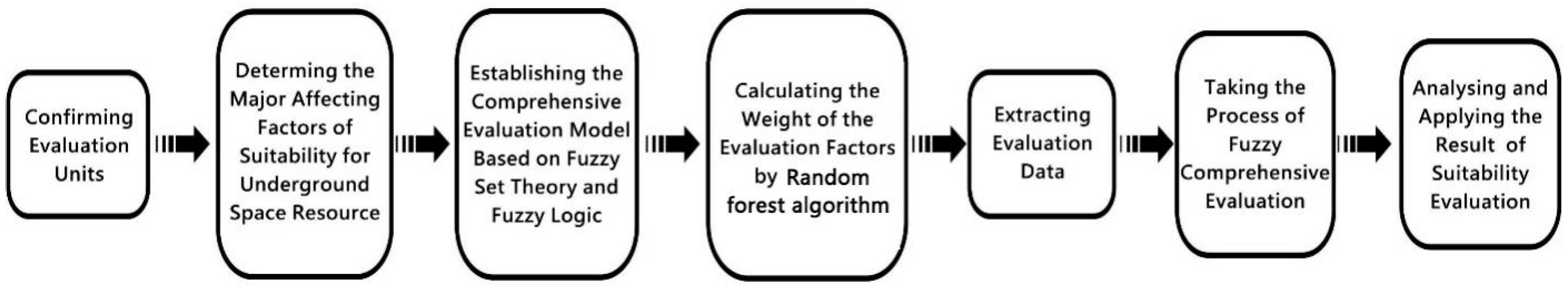
4.1. Suitability Evaluation
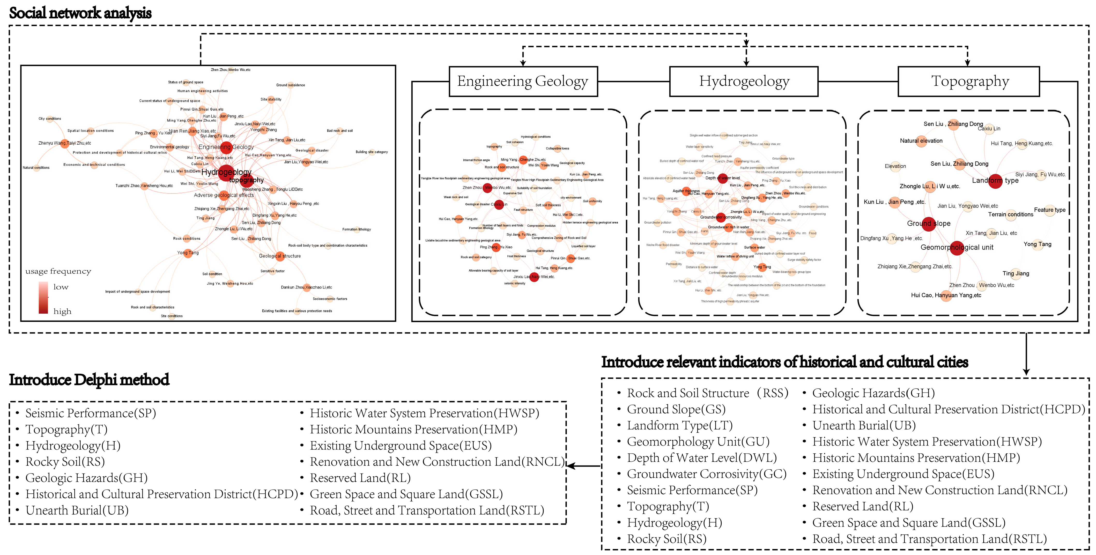
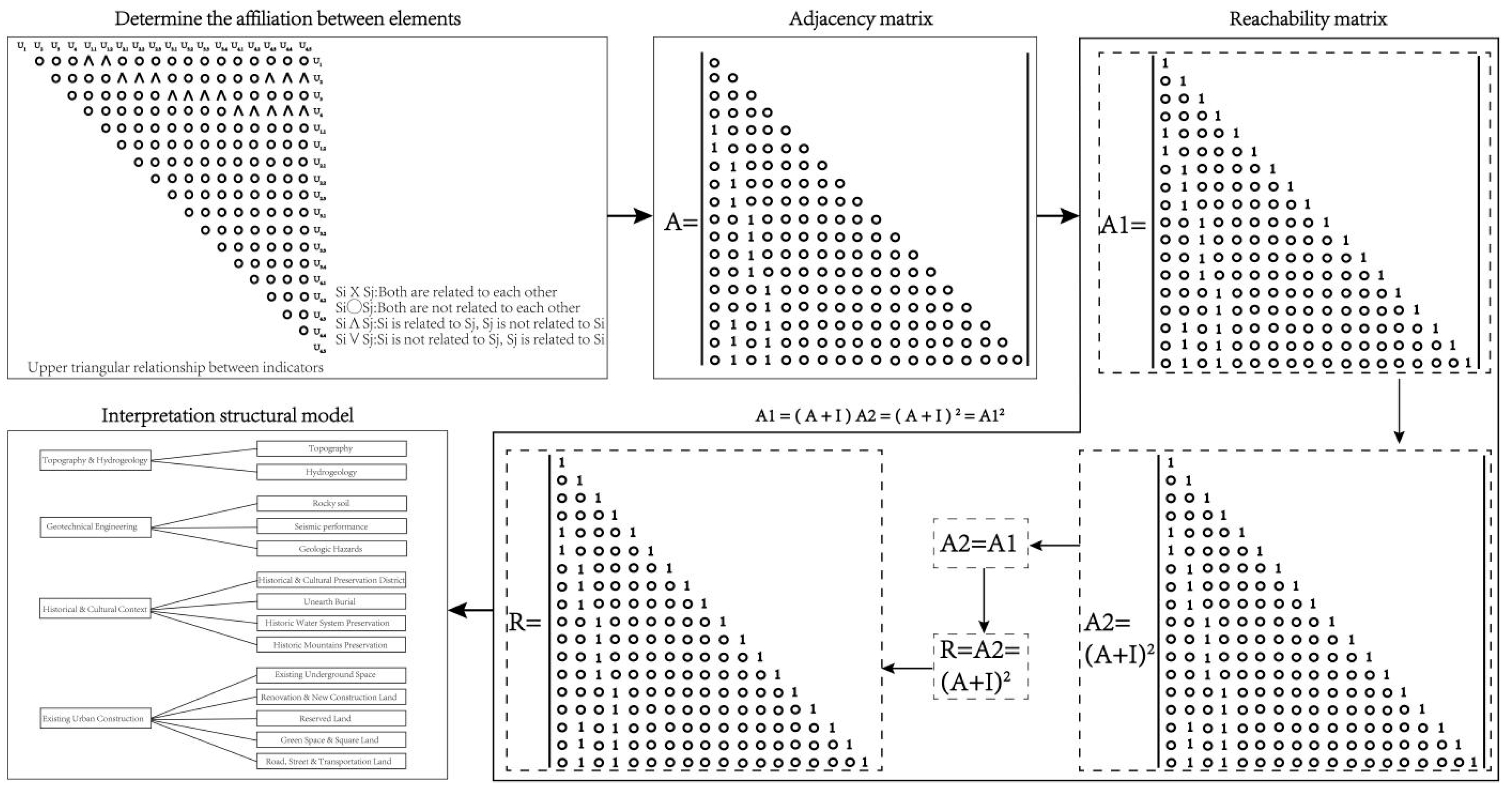
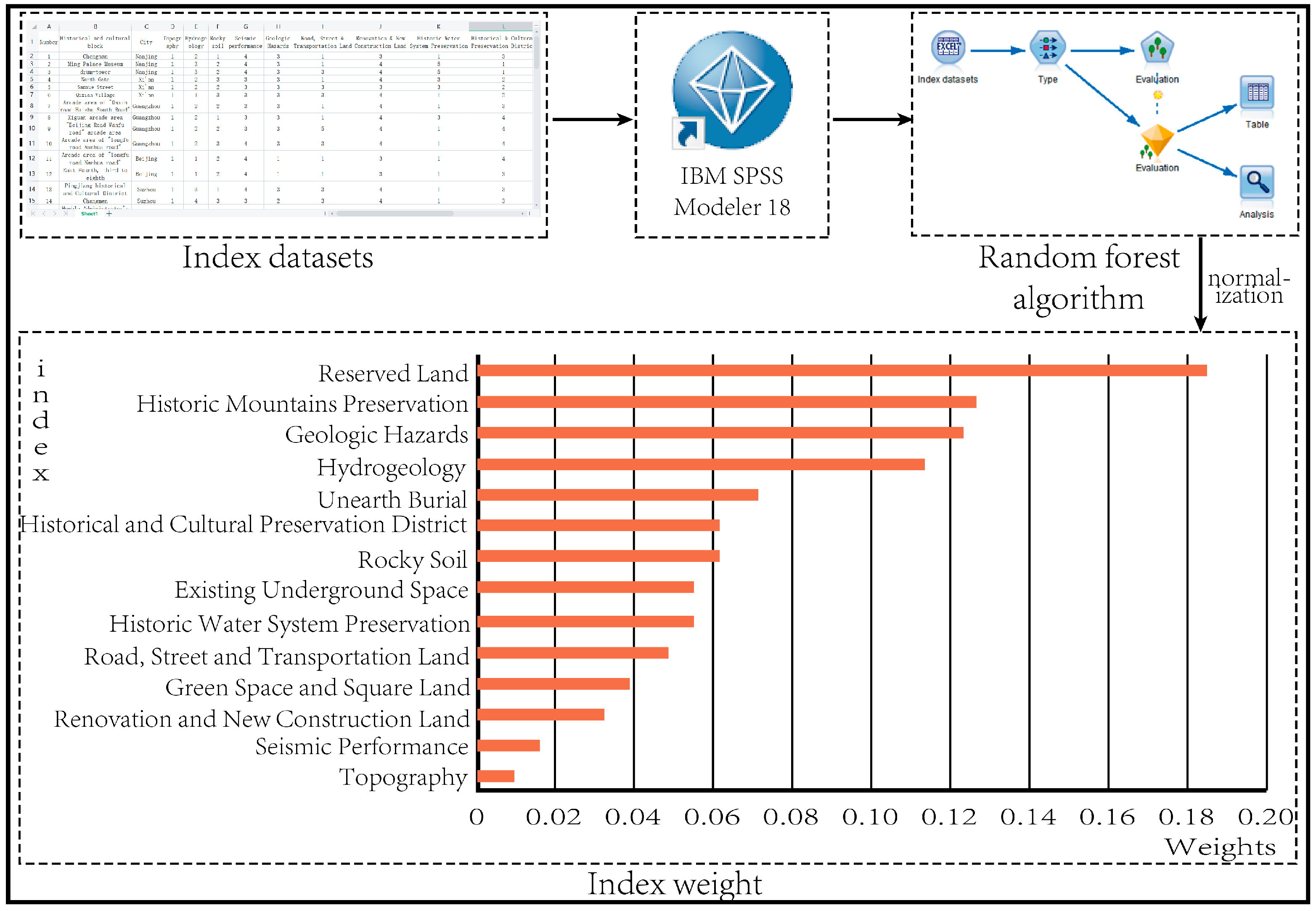
4.1.1. Index System Construction
4.1.2. Evaluation Result Calculation
- (1)
- The set of objects, factors, and grades
- (2)
- Membership function and mapping matrix
- (3)
- Establish a fuzzy mapping matrix
- (4)
- The weight of the evaluation factor
- (5)
- The overall appraisal result
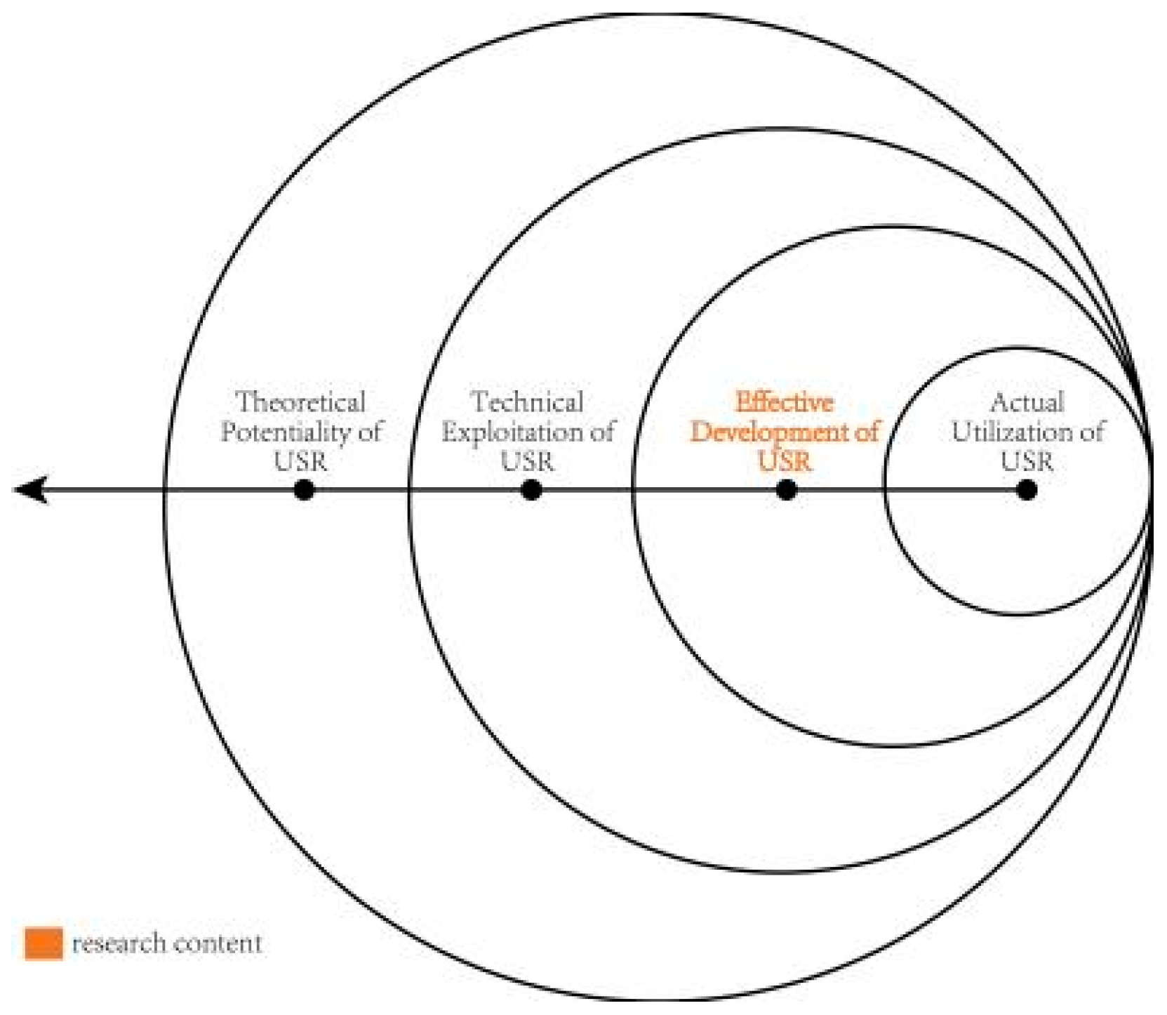
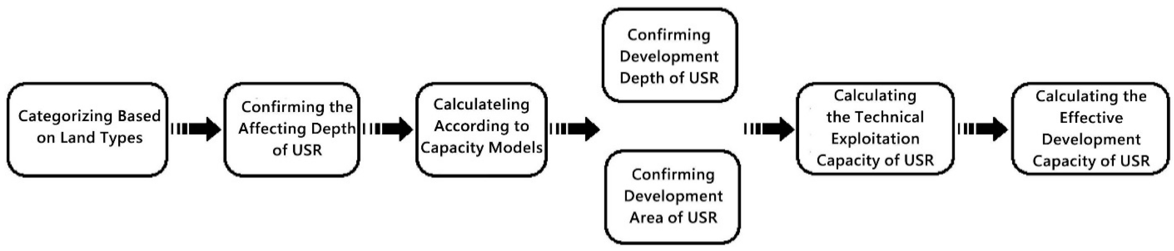
4.2. Capacity Evaluation
- (1)
- Theoretical potentiality of USR: the total theoretical capacity beneath the surface of the earth within the study area, including both exploited and residual capacities.
- (2)
- Technical exploitation of USR: the total amount of space beneath the ground surface that can be constructed by existing engineering technologies within the study area, which is not affected by constraints such as various topography, urban development, and construction condition.
- (3)
- Effective development of USR: the capacity is potentially available for development and construction with the reasonable development density, the various influencing factors, and the land value.
- (4)
- Actual utilisation of USR: the actual underground space construction under the condition of satisfying all constraints, such as historical and cultural protection, ecological environment coordination, and urban development demand.
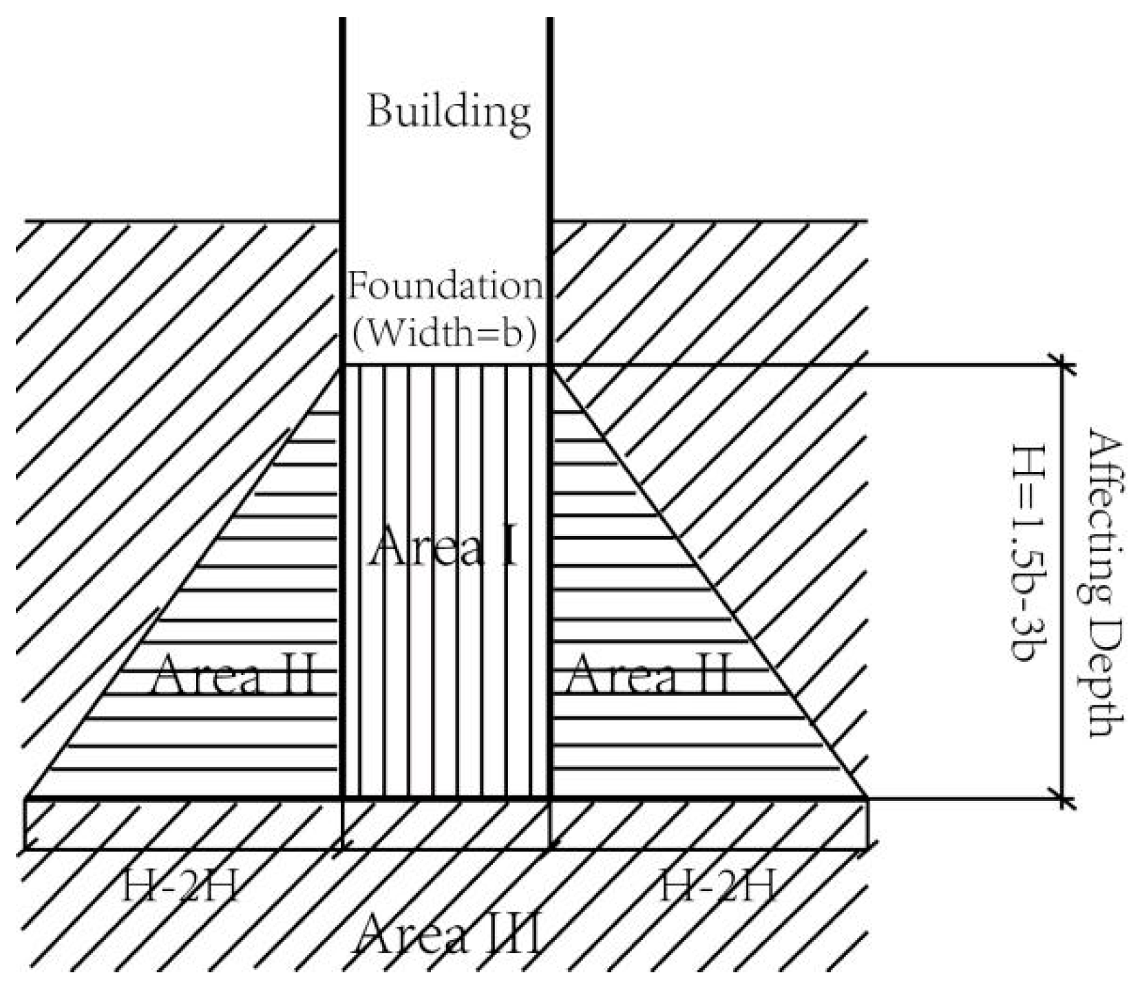
- (1)
- Area I is the affected area of the superimposed stress caused by building loads, and the affecting depth is H = 1.5b − 3b. The construction of the underground space in Area I must be strictly prohibited.
- (2)
- Area II is the affected area of foundation stability caused by shear stress, and the construction of underground space requires specific engineering measures to relieve the shear stress. The USR in Area II must be controlled.
- (3)
- Area III has fewer effects on the stability of the building foundation, which is suitable for the development of underground spaces. Area III is the reservation area of the USR.
4.3. Scale Forecast
4.3.1. Underground Space Demand
4.3.2. Value of Underground Space
4.3.3. Planning Volume of Underground Space
4.3.4. Statistics and Analysis of Evaluation Results
5. Results
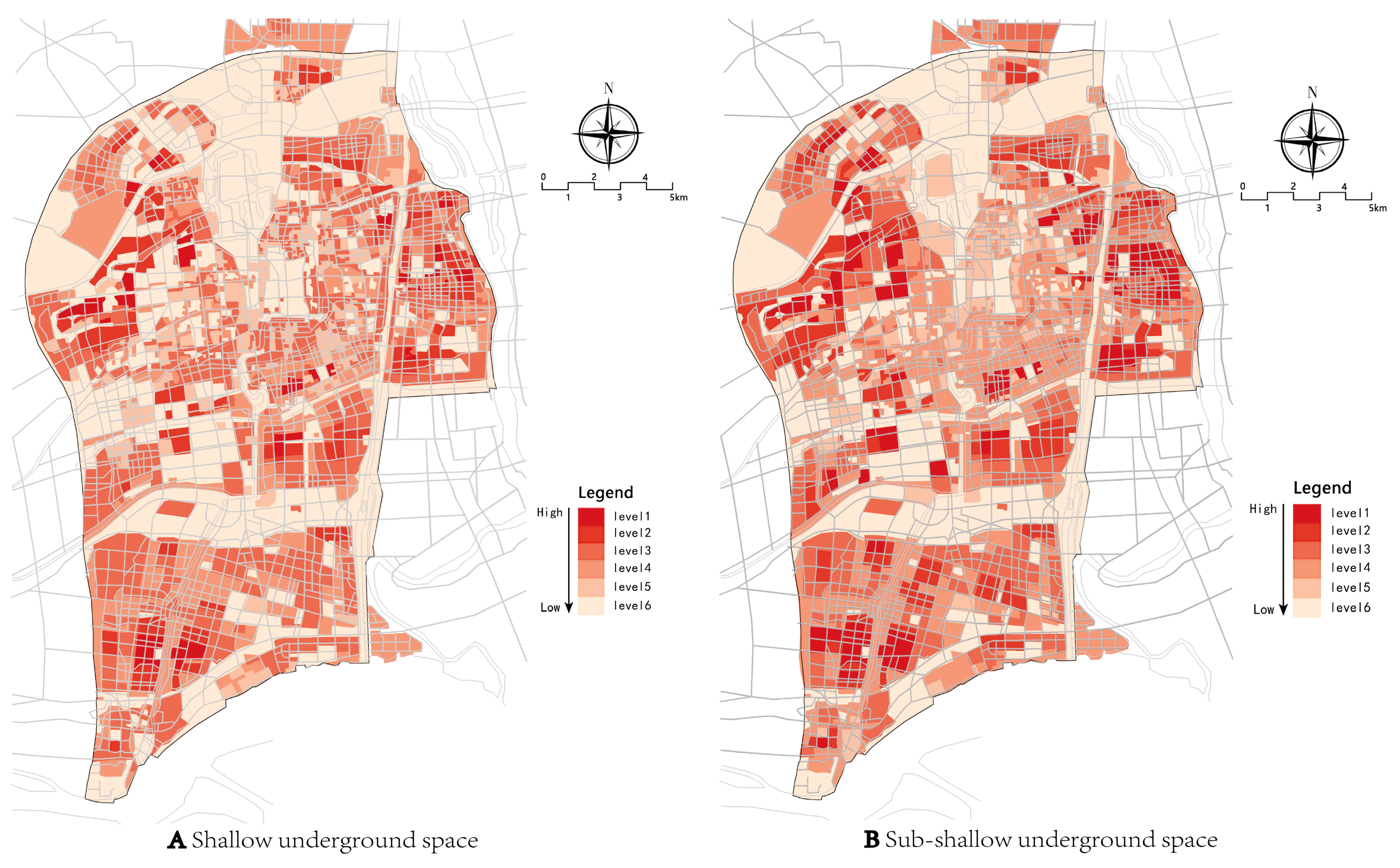
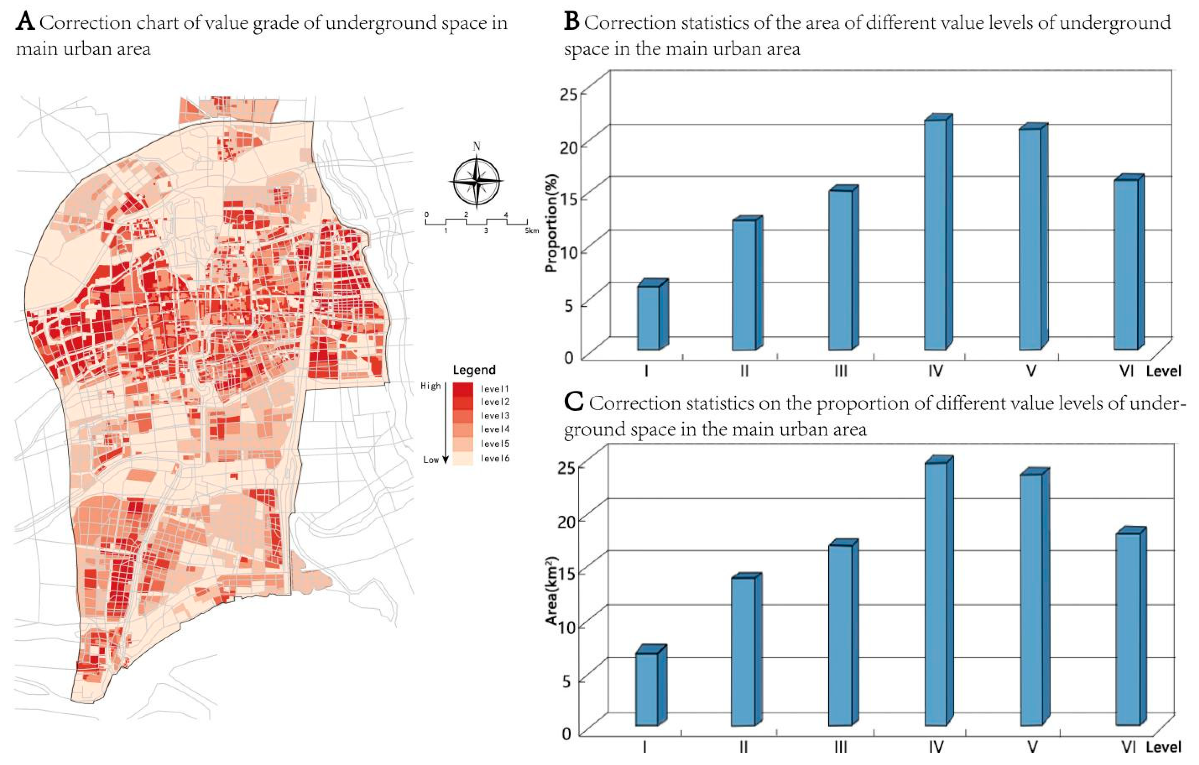
5.1. Results of Suitability Evaluation
5.2. Capacity Evaluation of USR for Yangzhou
5.2.1. Technical Exploitation Capacity of USR
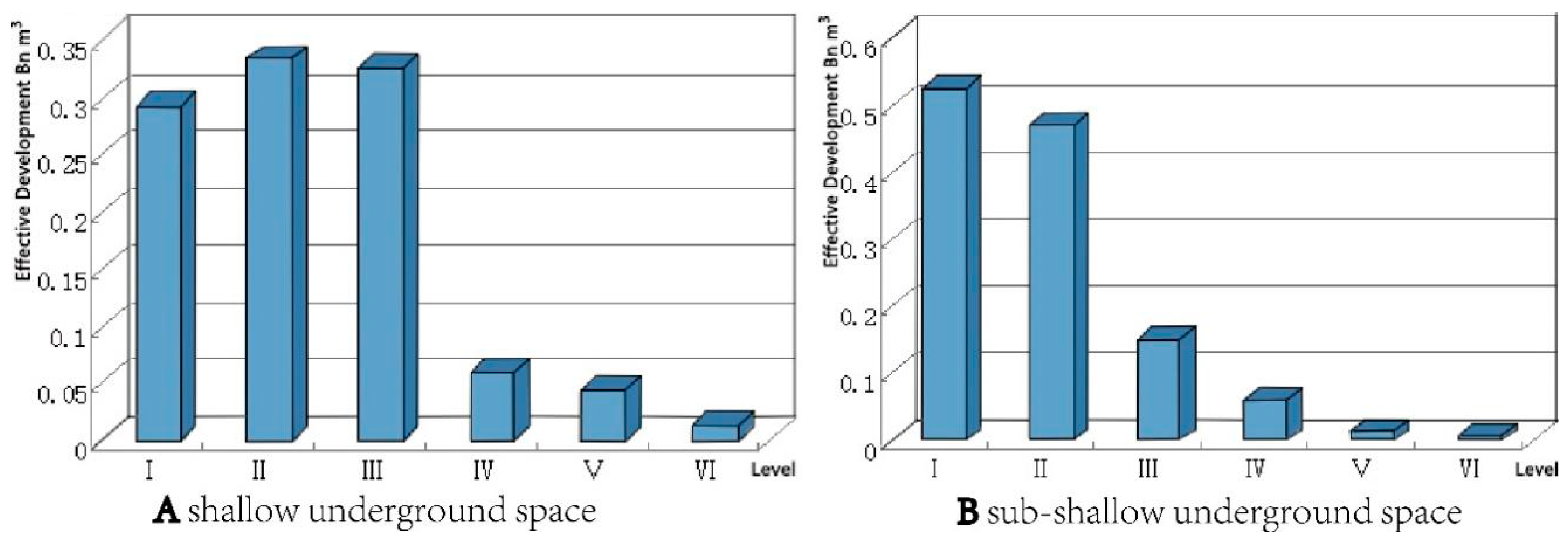
5.2.2. Effective Development Capacity of USR
5.3. Scale Forecast
5.3.1. Demand Forecast
5.3.2. Value of Underground Space
5.3.3. Planning Volume of Underground Space
6. Discussion
7. Conclusions
Author Contributions
Funding
Data Availability Statement
Acknowledgments
Conflicts of Interest
Appendix A

| Index Level 1 | Maosheng Zhang, Tonglu Li, etc. | Ping Zhang, Yu Xiao | Kun Liu, Jian Peng, etc. | Sen Liu, Zhiliang Dong | Xingxin Liu, Haiyou Peng, etc. | Pinrui Qin, Shuai Gao, etc. |
|---|---|---|---|---|---|---|
| Site stability | 0 | 0 | 1 | 0 | 0 | 0 |
| Current status of underground space | 0 | 1 | 1 | 0 | 0 | 0 |
| Status of ground space | 0 | 0 | 1 | 0 | 0 | 0 |
| Protection and development of historical cultural relics | 0 | 1 | 0 | 0 | 0 | 0 |
| Spatial location conditions | 0 | 1 | 0 | 0 | 0 | 0 |
| Sensitive factor | 0 | 0 | 0 | 1 | 0 | 0 |
| Formation lithology | 0 | 0 | 0 | 0 | 1 | 0 |
| Ground subsidence | 0 | 0 | 0 | 0 | 0 | 0 |
| Rock conditions | 0 | 0 | 0 | 0 | 0 | 0 |
| Bad rock and soil | 0 | 0 | 0 | 0 | 0 | 0 |
| Building site category | 0 | 0 | 0 | 0 | 0 | 0 |
| Sensitive factor | 0 | 0 | 0 | 0 | 0 | 0 |
| City conditions | 0 | 0 | 0 | 0 | 0 | 0 |
| Natural conditions | 0 | 0 | 0 | 0 | 0 | 0 |
| Economic and technical conditions | 0 | 0 | 0 | 0 | 0 | 0 |
| Rock-soil body type and combination characteristics | 0 | 0 | 0 | 0 | 0 | 0 |
| Rock and soil characteristics | 0 | 0 | 0 | 0 | 0 | 0 |
| Impact of underground space development | 0 | 0 | 0 | 0 | 0 | 0 |
| Site conditions | 0 | 0 | 0 | 0 | 0 | 0 |
| Cost per unit area | 0 | 0 | 0 | 0 | 0 | 0 |
| Existing facilities and various protection needs | 0 | 0 | 0 | 0 | 0 | 0 |
| Socioeconomic factors | 0 | 0 | 0 | 0 | 0 | 0 |
| Geological structure | 1 | 0 | 0 | 1 | 1 | 0 |
| Geological disaster | 1 | 0 | 0 | 0 | 0 | 0 |
| Environmental geology | 0 | 0 | 0 | 0 | 0 | 1 |
| Human engineering activities | 0 | 0 | 0 | 0 | 0 | 1 |
| Adverse geological effects | 0 | 0 | 0 | 1 | 0 | 0 |
| Soil condition | 0 | 0 | 0 | 0 | 0 | 0 |
| topography | 1 | 0 | 1 | 1 | 1 | 0 |
| Engineering Geology | 1 | 1 | 1 | 0 | 0 | 1 |
| Hydrogeology | 1 | 1 | 1 | 1 | 1 | 1 |
| Index Level 1 | Zhiqiang Xie, Zhengang Zhai, etc. | Yongzhi Zhang | Jing Ye, Weisheng Hou, etc. | Ming Yang, Chenghe Zhu, etc. | Jian Liu, Yongyao Wei, etc. | Zhen Zhou, Wenbo Wu, etc. |
|---|---|---|---|---|---|---|
| Site stability | 0 | 1 | 0 | 0 | 0 | 0 |
| Current status of underground space | 0 | 0 | 0 | 0 | 0 | 0 |
| Status of ground space | 0 | 0 | 0 | 0 | 0 | 0 |
| Protection and development of historical cultural relics | 0 | 0 | 0 | 0 | 0 | 0 |
| Spatial location conditions | 0 | 0 | 0 | 0 | 0 | 0 |
| Sensitive factor | 0 | 0 | 0 | 0 | 0 | 0 |
| Formation lithology | 0 | 0 | 0 | 0 | 0 | 0 |
| Ground subsidence | 0 | 1 | 0 | 0 | 0 | 0 |
| Rock conditions | 0 | 0 | 1 | 0 | 0 | 0 |
| Bad rock and soil | 0 | 0 | 0 | 0 | 1 | 0 |
| Building site category | 0 | 0 | 0 | 0 | 1 | 0 |
| Sensitive factor | 0 | 0 | 0 | 0 | 0 | 0 |
| City conditions | 0 | 0 | 0 | 0 | 0 | 0 |
| Natural conditions | 0 | 0 | 0 | 0 | 0 | 0 |
| Economic and technical conditions | 0 | 0 | 0 | 0 | 0 | 0 |
| Rock-soil body type and combination characteristics | 0 | 0 | 0 | 0 | 0 | 0 |
| Rock and soil characteristics | 0 | 0 | 0 | 0 | 0 | 0 |
| Impact of underground space development | 0 | 0 | 0 | 0 | 0 | 0 |
| Site conditions | 0 | 0 | 0 | 0 | 0 | 0 |
| Cost per unit area | 0 | 0 | 0 | 0 | 0 | 0 |
| Existing facilities and various protection needs | 0 | 0 | 0 | 0 | 0 | 0 |
| Socioeconomic factors | 0 | 0 | 0 | 0 | 0 | 0 |
| Geological structure | 0 | 0 | 1 | 0 | 0 | 0 |
| Geological disaster | 0 | 0 | 0 | 0 | 1 | 0 |
| Environmental geology | 0 | 0 | 0 | 1 | 0 | 0 |
| Human engineering activities | 0 | 0 | 0 | 1 | 0 | 0 |
| Adverse geological effects | 1 | 0 | 0 | 0 | 0 | 0 |
| Soil condition | 1 | 0 | 1 | 0 | 0 | 0 |
| topography | 1 | 1 | 0 | 0 | 1 | 0 |
| Engineering Geology | 1 | 1 | 0 | 1 | 0 | 1 |
| Hydrogeology | 1 | 1 | 0 | 1 | 1 | 0 |
| Index Level 1 | Jinxiu Lao, Naiyi Wei, etc. | Nian Ren, Jiang Xiao, etc. | Hui Tang, Heng Kuang, etc. | Hui Li, Wei Shi, etc. | Xin Tang, Jian Liu, etc. | Ting Jiang |
|---|---|---|---|---|---|---|
| Site stability | 1 | 0 | 0 | 0 | 1 | 0 |
| Current status of underground space | 0 | 1 | 0 | 0 | 0 | 0 |
| Status of ground space | 0 | 1 | 0 | 0 | 0 | 0 |
| Protection and development of historical cultural relics | 0 | 1 | 0 | 1 | 0 | 0 |
| Spatial location conditions | 0 | 0 | 0 | 0 | 0 | 0 |
| Sensitive factor | 0 | 0 | 0 | 0 | 0 | 0 |
| Formation lithology | 0 | 0 | 0 | 0 | 0 | 0 |
| Ground subsidence | 1 | 0 | 0 | 0 | 0 | 0 |
| Rock conditions | 0 | 0 | 0 | 0 | 0 | 1 |
| Bad rock and soil | 0 | 0 | 0 | 0 | 1 | 0 |
| Building site category | 0 | 0 | 0 | 0 | 0 | 0 |
| Sensitive factor | 0 | 0 | 0 | 0 | 0 | 0 |
| City conditions | 0 | 0 | 0 | 0 | 0 | 0 |
| Natural conditions | 0 | 0 | 0 | 0 | 0 | 0 |
| Economic and technical conditions | 0 | 0 | 0 | 0 | 0 | 0 |
| Rock-soil body type and combination characteristics | 0 | 0 | 0 | 0 | 0 | 0 |
| Rock and soil characteristics | 0 | 0 | 0 | 0 | 0 | 0 |
| Impact of underground space development | 0 | 0 | 0 | 0 | 0 | 0 |
| Site conditions | 0 | 0 | 0 | 0 | 0 | 0 |
| Cost per unit area | 0 | 0 | 0 | 0 | 0 | 0 |
| Existing facilities and various protection needs | 0 | 0 | 0 | 0 | 0 | 0 |
| Socioeconomic factors | 0 | 0 | 0 | 0 | 0 | 0 |
| Geological structure | 0 | 0 | 0 | 0 | 0 | 0 |
| Geological disaster | 0 | 0 | 0 | 0 | 1 | 0 |
| Environmental geology | 0 | 0 | 1 | 0 | 0 | 0 |
| Human engineering activities | 0 | 0 | 0 | 0 | 0 | 0 |
| Adverse geological effects | 0 | 1 | 0 | 1 | 0 | 1 |
| Soil condition | 0 | 0 | 0 | 0 | 0 | 0 |
| topography | 1 | 1 | 1 | 0 | 1 | 1 |
| Engineering Geology | 1 | 1 | 1 | 1 | 0 | 0 |
| Hydrogeology | 1 | 1 | 1 | 1 | 1 | 1 |
| Index Level 1 | Sen Liu, Zhiliang Dong | Hui Cao, Hanyuan Yang, etc. | Zhenyu Wang, Taiyi Zhu, etc. | Siyi Jiang, Fu Wu, etc. | Dingfang Xu, Yang He, etc. | Caixiu Lin |
|---|---|---|---|---|---|---|
| Site stability | 0 | 0 | 0 | 0 | 0 | 0 |
| Current status of underground space | 0 | 0 | 0 | 0 | 0 | 0 |
| Status of ground space | 0 | 0 | 0 | 0 | 0 | 0 |
| Protection and development of historical cultural relics | 0 | 0 | 0 | 0 | 0 | 0 |
| Spatial location conditions | 0 | 0 | 1 | 0 | 0 | 0 |
| Sensitive factor | 0 | 0 | 0 | 0 | 0 | 0 |
| Formation lithology | 0 | 0 | 0 | 0 | 0 | 0 |
| Ground subsidence | 0 | 0 | 0 | 0 | 0 | 0 |
| Rock conditions | 0 | 0 | 0 | 0 | 0 | 0 |
| Bad rock and soil | 0 | 0 | 0 | 0 | 0 | 0 |
| Building site category | 0 | 0 | 0 | 0 | 0 | 0 |
| Sensitive factor | 1 | 0 | 0 | 0 | 0 | 0 |
| City conditions | 0 | 0 | 1 | 0 | 0 | 0 |
| Natural conditions | 0 | 0 | 1 | 0 | 0 | 0 |
| Economic and technical conditions | 0 | 0 | 1 | 0 | 0 | 0 |
| Rock-soil body type and combination characteristics | 0 | 0 | 0 | 0 | 1 | 0 |
| Rock and soil characteristics | 0 | 0 | 0 | 0 | 0 | 0 |
| Impact of underground space development | 0 | 0 | 0 | 0 | 0 | 0 |
| Site conditions | 0 | 0 | 0 | 0 | 0 | 0 |
| Cost per unit area | 0 | 0 | 0 | 0 | 0 | 0 |
| Existing facilities and various protection needs | 0 | 0 | 0 | 0 | 0 | 0 |
| Socioeconomic factors | 0 | 0 | 0 | 0 | 0 | 0 |
| Geological structure | 1 | 0 | 0 | 0 | 1 | 0 |
| Geological disaster | 0 | 1 | 0 | 0 | 0 | 0 |
| Environmental geology | 0 | 0 | 0 | 0 | 0 | 1 |
| Human engineering activities | 0 | 0 | 0 | 1 | 0 | 0 |
| Adverse geological effects | 1 | 0 | 0 | 1 | 1 | 0 |
| Soil condition | 0 | 0 | 0 | 0 | 0 | 0 |
| topography | 1 | 1 | 0 | 1 | 1 | 1 |
| Engineering Geology | 0 | 1 | 0 | 1 | 0 | 1 |
| Hydrogeology | 1 | 1 | 0 | 1 | 1 | 1 |
| Index Level 1 | Wei Shi, Youlin Wang | Tuanzhi Zhao, Yansheng Hou, etc. | Yong Tang | Dankun Zhou, Xiaozhao Li, etc. | Zhongle Lu, Li Wu, etc. |
|---|---|---|---|---|---|
| Site stability | 0 | 0 | 0 | 0 | 0 |
| Current status of underground space | 0 | 0 | 0 | 0 | 0 |
| Status of ground space | 0 | 0 | 0 | 0 | 0 |
| Protection and development of historical cultural relics | 0 | 0 | 0 | 0 | 0 |
| Spatial location conditions | 0 | 0 | 0 | 0 | 0 |
| Sensitive factor | 0 | 0 | 0 | 0 | 0 |
| Formation lithology | 0 | 0 | 0 | 0 | 0 |
| Ground subsidence | 0 | 0 | 0 | 0 | 0 |
| Rock conditions | 0 | 1 | 0 | 0 | 1 |
| Bad rock and soil | 0 | 0 | 0 | 0 | 0 |
| Building site category | 0 | 0 | 0 | 0 | 0 |
| Sensitive factor | 0 | 0 | 0 | 0 | 0 |
| City conditions | 0 | 0 | 0 | 0 | 0 |
| Natural conditions | 0 | 0 | 0 | 0 | 0 |
| Economic and technical conditions | 0 | 1 | 0 | 0 | 0 |
| Rock-soil body type and combination characteristics | 0 | 0 | 0 | 0 | 0 |
| Rock and soil characteristics | 0 | 0 | 1 | 0 | 0 |
| Impact of underground space development | 0 | 0 | 1 | 0 | 0 |
| Site conditions | 0 | 0 | 1 | 0 | 0 |
| Cost per unit area | 0 | 0 | 0 | 0 | 0 |
| Existing facilities and various protection needs | 0 | 0 | 0 | 1 | 0 |
| Socioeconomic factors | 0 | 0 | 0 | 1 | 0 |
| Geological structure | 0 | 0 | 0 | 1 | 1 |
| Geological disaster | 0 | 0 | 0 | 0 | 0 |
| Environmental geology | 0 | 1 | 0 | 0 | 0 |
| Human engineering activities | 0 | 0 | 0 | 0 | 0 |
| Adverse geological effects | 1 | 0 | 0 | 0 | 1 |
| Soil condition | 0 | 0 | 0 | 0 | 0 |
| topography | 0 | 0 | 1 | 0 | 1 |
| Engineering Geology | 1 | 0 | 0 | 0 | 0 |
| Hydrogeology | 1 | 1 | 1 | 0 | 1 |
| Index Level 2 | Kun Liu, Jian Peng, etc. | Sen Liu, Zhiliang Dong | Zhiqiang Xie, Zhengang Zhai, etc. | Jian Liu, Yongyao Wei, etc. | Zhen Zhou, Wenbo Wu, etc. | Hui Tang, Heng Kuang, etc. |
|---|---|---|---|---|---|---|
| Elevation | 1 | 0 | 0 | 0 | 0 | 0 |
| Ground slope | 1 | 0 | 1 | 0 | 0 | 0 |
| Landform type | 0 | 1 | 0 | 0 | 0 | 1 |
| Feature type | 0 | 0 | 0 | 0 | 0 | 0 |
| Geomorphological unit | 0 | 0 | 0 | 1 | 1 | 0 |
| Natural elevation | 0 | 1 | 0 | 0 | 0 | 0 |
| Terrain conditions | 0 | 0 | 0 | 0 | 0 | 0 |
| Index Level 2 | Xin Tang, Jian Liu, etc. | Ting Jiang | Sen Liu, Zhiliang Dong | Hui Cao, Hanyuan Yang, etc. | Siyi Jiang, Fu Wu, etc. | Dingfang Xu, Yang He, etc. |
|---|---|---|---|---|---|---|
| Elevation | 0 | 0 | 0 | 0 | 0 | 0 |
| Ground slope | 0 | 0 | 0 | 1 | 0 | 1 |
| Landform type | 0 | 0 | 1 | 0 | 1 | 0 |
| Feature type | 0 | 0 | 0 | 0 | 0 | 0 |
| Geomorphological unit | 1 | 0 | 0 | 1 | 0 | 0 |
| Natural elevation | 0 | 0 | 1 | 0 | 0 | 0 |
| Terrain conditions | 0 | 1 | 0 | 0 | 0 | 0 |
| Index Level 2 | Caixiu Lin | Yong Tang | Zhongle Lu, Li Wu, etc. | Caixiu Lin |
|---|---|---|---|---|
| Elevation | 0 | 0 | 0 | 0 |
| Ground slope | 0 | 0 | 1 | 0 |
| Landform type | 1 | 0 | 0 | 1 |
| Feature type | 0 | 1 | 0 | 0 |
| Geomorphological unit | 0 | 0 | 1 | 0 |
| Natural elevation | 0 | 0 | 0 | 0 |
| Terrain conditions | 0 | 0 | 0 | 0 |
| Index Level 2 | Maosheng Zhang, Tonglu Li, etc. | Ping Zhang, Yu Xiao | Kun Liu, Jian Peng, etc. | Sen Liu, Zhiliang Dong | Xingxin Liu, Haiyou Peng, etc. | Pinrui Qin, Shuai Gao, etc. |
|---|---|---|---|---|---|---|
| Depth of water level | 1 | 1 | 1 | 0 | 0 | 1 |
| Aquifer thickness | 0 | 0 | 1 | 0 | 0 | 1 |
| Groundwater corrosivity | 0 | 1 | 1 | 1 | 1 | 1 |
| Groundwater rich in water | 0 | 0 | 0 | 1 | 0 | 1 |
| Minimum depth of groundwater level | 0 | 0 | 0 | 1 | 0 | 0 |
| The influence of underground river on underground space development | 0 | 0 | 0 | 0 | 0 | 0 |
| Groundwater type | 0 | 0 | 0 | 0 | 0 | 0 |
| Groundwater resources modulus | 0 | 0 | 0 | 0 | 0 | 0 |
| Groundwater pollution | 0 | 0 | 0 | 0 | 0 | 0 |
| Surface water | 0 | 0 | 0 | 1 | 0 | 0 |
| Water inflow of diving unit | 1 | 0 | 0 | 0 | 0 | 1 |
| Weihe River flood disaster | 0 | 0 | 0 | 0 | 0 | 0 |
| Confined water depth | 0 | 0 | 0 | 0 | 0 | 0 |
| Aquifer permeability coefficient | 0 | 0 | 0 | 0 | 0 | 0 |
| Permeability | 0 | 0 | 0 | 0 | 0 | 0 |
| Thickness of high permeability phreatic aquifer | 0 | 0 | 0 | 0 | 0 | 0 |
| Surge stability safety factor | 0 | 0 | 0 | 0 | 0 | 0 |
| The relationship between the bottom of the pit and the bottom of the foundation | 0 | 0 | 0 | 0 | 0 | 0 |
| Minimum depth of groundwater level | 0 | 0 | 0 | 0 | 0 | 0 |
| Impact of water quality on underground engineering | 1 | 0 | 0 | 0 | 0 | 0 |
| Soil thickness and distribution | 0 | 0 | 0 | 0 | 0 | 0 |
| Single well water inflow in confined submerged section | 0 | 0 | 0 | 0 | 0 | 0 |
| Absolute elevation of confined water head | 0 | 1 | 0 | 0 | 0 | 0 |
| Buried depth of confined water layer roof | 0 | 1 | 0 | 0 | 0 | 0 |
| Groundwater conditions | 0 | 0 | 0 | 0 | 1 | 0 |
| Water-bearing rock group type | 0 | 0 | 0 | 0 | 0 | 0 |
| Buried depth of confined water roof | 0 | 0 | 0 | 0 | 0 | 0 |
| Confined head pressure | 0 | 0 | 0 | 0 | 0 | 0 |
| Water layer sensitivity | 0 | 0 | 0 | 0 | 0 | 0 |
| Flood | 0 | 0 | 0 | 0 | 0 | 0 |
| Karst | 0 | 0 | 0 | 0 | 0 | 0 |
| Distance to surface water | 0 | 0 | 0 | 0 | 0 | 0 |
| Index Level 2 | Ming Yang, Chenghe Zhu, etc. | Jian Liu, Yongyao Wei, etc. | Zhen Zhou, Wenbo Wu, etc. | Jinxiu Lao, Naiyi Wei, etc. | Nian Ren, Jiang Xiao, etc. | Hui Tang, Heng Kuang, etc. |
|---|---|---|---|---|---|---|
| Depth of water level | 0 | 0 | 0 | 0 | 1 | 1 |
| Aquifer thickness | 0 | 0 | 0 | 1 | 0 | 1 |
| Groundwater corrosivity | 1 | 0 | 0 | 0 | 0 | 1 |
| Groundwater rich in water | 1 | 0 | 0 | 0 | 1 | 1 |
| Minimum depth of groundwater level | 0 | 0 | 0 | 0 | 0 | 0 |
| The influence of underground river on underground space development | 0 | 0 | 0 | 0 | 0 | 0 |
| Groundwater type | 0 | 0 | 0 | 0 | 0 | 0 |
| Groundwater resources modulus | 0 | 0 | 0 | 0 | 0 | 0 |
| Groundwater pollution | 0 | 0 | 0 | 0 | 0 | 0 |
| Surface water | 1 | 1 | 1 | 0 | 0 | 0 |
| Water inflow of diving unit | 0 | 1 | 0 | 0 | 0 | 0 |
| Weihe River flood disaster | 0 | 0 | 0 | 0 | 0 | 0 |
| Confined water depth | 0 | 0 | 0 | 0 | 0 | 0 |
| Aquifer permeability coefficient | 0 | 0 | 0 | 0 | 0 | 0 |
| Permeability | 0 | 0 | 0 | 0 | 0 | 0 |
| Thickness of high permeability phreatic aquifer | 0 | 0 | 0 | 0 | 0 | 0 |
| Surge stability safety factor | 0 | 0 | 0 | 0 | 0 | 0 |
| The relationship between the bottom of the pit and the bottom of the foundation | 0 | 0 | 0 | 0 | 0 | 0 |
| Minimum depth of groundwater level | 1 | 0 | 0 | 0 | 0 | 0 |
| Impact of water quality on underground engineering | 0 | 0 | 0 | 0 | 0 | 0 |
| Soil thickness and distribution | 0 | 0 | 1 | 0 | 0 | 0 |
| Single well water inflow in confined submerged section | 0 | 0 | 1 | 0 | 0 | 0 |
| Absolute elevation of confined water head | 0 | 0 | 0 | 0 | 0 | 0 |
| Buried depth of confined water layer roof | 0 | 0 | 0 | 0 | 0 | 0 |
| Groundwater conditions | 0 | 0 | 0 | 0 | 0 | 0 |
| Water-bearing rock group type | 0 | 0 | 0 | 0 | 1 | 0 |
| Buried depth of confined water roof | 0 | 0 | 0 | 0 | 0 | 0 |
| Confined head pressure | 0 | 0 | 0 | 0 | 0 | 0 |
| Water layer sensitivity | 0 | 0 | 0 | 0 | 0 | 0 |
| Flood | 0 | 0 | 0 | 0 | 0 | 0 |
| Karst | 0 | 0 | 1 | 0 | 0 | 0 |
| Distance to surface water | 0 | 0 | 0 | 0 | 1 | 0 |
| Index Level 2 | Hui Li, Wei Shi, etc. | Xin Tang, Jian Liu, etc. | Ting Jiang | Sen Liu, Zhiliang Dong | Hui Cao, Hanyuan Yang, etc. | Siyi Jiang, Fu Wu, etc. |
|---|---|---|---|---|---|---|
| Depth of water level | 0 | 0 | 1 | 1 | 1 | 0 |
| Aquifer thickness | 1 | 0 | 0 | 1 | 0 | 0 |
| Groundwater corrosivity | 0 | 0 | 0 | 1 | 0 | 0 |
| Groundwater rich in water | 0 | 1 | 0 | 0 | 0 | 1 |
| Minimum depth of groundwater level | 0 | 0 | 0 | 0 | 0 | 1 |
| The influence of underground river on underground space development | 0 | 0 | 0 | 0 | 0 | 1 |
| Groundwater type | 0 | 0 | 0 | 0 | 1 | 0 |
| Groundwater resources modulus | 0 | 0 | 0 | 0 | 1 | 0 |
| Groundwater pollution | 0 | 0 | 0 | 0 | 1 | 0 |
| Surface water | 1 | 0 | 0 | 0 | 0 | 0 |
| Water inflow of diving unit | 1 | 0 | 0 | 0 | 0 | 0 |
| Weihe River flood disaster | 1 | 0 | 0 | 0 | 0 | 0 |
| Confined water depth | 0 | 0 | 0 | 0 | 0 | 0 |
| Aquifer permeability coefficient | 0 | 0 | 0 | 0 | 0 | 0 |
| Permeability | 0 | 0 | 0 | 0 | 0 | 0 |
| Thickness of high permeability phreatic aquifer | 0 | 0 | 0 | 0 | 0 | 0 |
| Surge stability safety factor | 0 | 0 | 0 | 0 | 0 | 0 |
| The relationship between the bottom of the pit and the bottom of the foundation | 0 | 0 | 0 | 0 | 0 | 0 |
| Minimum depth of groundwater level | 0 | 0 | 0 | 0 | 0 | 0 |
| Impact of water quality on underground engineering | 0 | 0 | 0 | 0 | 0 | 0 |
| Soil thickness and distribution | 0 | 0 | 0 | 0 | 0 | 0 |
| Single well water inflow in confined submerged section | 0 | 0 | 0 | 0 | 0 | 0 |
| Absolute elevation of confined water head | 0 | 0 | 0 | 0 | 0 | 0 |
| Buried depth of confined water layer roof | 0 | 0 | 0 | 0 | 0 | 0 |
| Groundwater conditions | 0 | 0 | 0 | 0 | 0 | 0 |
| Water-bearing rock group type | 0 | 0 | 0 | 0 | 0 | 0 |
| Buried depth of confined water roof | 0 | 0 | 0 | 0 | 0 | 0 |
| Confined head pressure | 0 | 0 | 0 | 0 | 0 | 0 |
| Water layer sensitivity | 0 | 0 | 0 | 0 | 0 | 0 |
| Flood | 0 | 0 | 0 | 0 | 0 | 0 |
| Karst | 0 | 0 | 0 | 0 | 0 | 0 |
| Distance to surface water | 0 | 0 | 0 | 0 | 0 | 0 |
| Index Level 2 | Dingfang Xu, Yang He, etc. | Caixiu Lin | Wei Shi, Youlin Wang | Tuanzhi Zhao, Yansheng Hou, etc. | Yong Tang | Zhongle Lu, Li Wu, etc. |
|---|---|---|---|---|---|---|
| Depth of water level | 1 | 1 | 0 | 1 | 0 | 1 |
| Aquifer thickness | 0 | 1 | 1 | 1 | 0 | 0 |
| Groundwater corrosivity | 1 | 1 | 0 | 1 | 1 | 0 |
| Groundwater rich in water | 1 | 0 | 0 | 0 | 0 | 0 |
| Minimum depth of groundwater level | 0 | 0 | 0 | 0 | 0 | 0 |
| The influence of underground river on underground space development | 0 | 0 | 0 | 0 | 0 | 0 |
| Groundwater type | 0 | 0 | 0 | 0 | 0 | 0 |
| Groundwater resources modulus | 0 | 0 | 0 | 0 | 0 | 0 |
| Groundwater pollution | 0 | 0 | 0 | 0 | 0 | 0 |
| Surface water | 0 | 0 | 1 | 0 | 0 | 0 |
| Water inflow of diving unit | 0 | 0 | 1 | 0 | 0 | 0 |
| Weihe River flood disaster | 0 | 0 | 1 | 0 | 0 | 0 |
| Confined water depth | 0 | 0 | 0 | 1 | 0 | 0 |
| Aquifer permeability coefficient | 0 | 1 | 0 | 0 | 0 | 0 |
| Permeability | 0 | 0 | 0 | 0 | 1 | 0 |
| Thickness of high permeability phreatic aquifer | 0 | 0 | 0 | 0 | 1 | 0 |
| Surge stability safety factor | 0 | 0 | 0 | 0 | 1 | 0 |
| The relationship between the bottom of the pit and the bottom of the foundation | 0 | 0 | 0 | 0 | 1 | 0 |
| Minimum depth of groundwater level | 0 | 0 | 0 | 0 | 0 | 0 |
| Impact of water quality on underground engineering | 0 | 0 | 0 | 0 | 0 | 0 |
| Soil thickness and distribution | 0 | 0 | 0 | 0 | 0 | 0 |
| Single well water inflow in confined submerged section | 0 | 0 | 0 | 0 | 0 | 0 |
| Absolute elevation of confined water head | 0 | 0 | 0 | 0 | 0 | 0 |
| Buried depth of confined water layer roof | 0 | 0 | 0 | 0 | 0 | 0 |
| Groundwater conditions | 0 | 0 | 0 | 0 | 0 | 0 |
| Water-bearing rock group type | 1 | 0 | 0 | 0 | 0 | 0 |
| Buried depth of confined water roof | 1 | 0 | 0 | 0 | 0 | 0 |
| Confined head pressure | 1 | 0 | 0 | 0 | 0 | 0 |
| Water layer sensitivity | 0 | 0 | 0 | 0 | 0 | 1 |
| Flood | 0 | 0 | 0 | 0 | 0 | 1 |
| Karst | 0 | 0 | 0 | 0 | 0 | 1 |
| Distance to surface water | 0 | 0 | 0 | 0 | 0 | 0 |
| Index Level 2 | Ping Zhang, Yu Xiao | Kun Liu, Jian Peng, etc. | Pinrui Qin, Shuai Gao, etc. | Ming Yang, Chenghe Zhu, etc. | Zhen Zhou, Wenbo Wu, etc. | Jinxiu Lao, Naiyi Wei, etc. |
|---|---|---|---|---|---|---|
| Soil uniformity | 1 | 1 | 0 | 1 | 0 | 1 |
| Soft soil thickness | 0 | 1 | 1 | 1 | 0 | 0 |
| topography | 1 | 1 | 0 | 1 | 1 | 0 |
| Weak rock and soil | 1 | 0 | 0 | 0 | 0 | 0 |
| Hydrological conditions | 0 | 0 | 0 | 0 | 0 | 0 |
| Geological disaster | 0 | 0 | 0 | 0 | 0 | 0 |
| city environment | 0 | 0 | 0 | 0 | 0 | 0 |
| Fault structure | 0 | 0 | 0 | 0 | 0 | 0 |
| Comprehensive Zoning of Rock and Soil | 0 | 0 | 0 | 0 | 0 | 0 |
| Collapsible loess | 0 | 0 | 1 | 0 | 0 | 0 |
| Yangtze River low floodplain sedimentary engineering geological area | 0 | 0 | 1 | 0 | 0 | 0 |
| Yangtze River High Floodplain Sedimentary Engineering Geological Area | 0 | 0 | 1 | 0 | 0 | 0 |
| Hidden terrace engineering geological area | 0 | 0 | 0 | 1 | 0 | 0 |
| Lixiahe lacustrine sedimentary engineering geological area | 0 | 1 | 0 | 0 | 0 | 0 |
| Number of fault layers and folds | 0 | 0 | 0 | 0 | 1 | 0 |
| Allowable bearing capacity of soil layer | 0 | 0 | 0 | 0 | 1 | 0 |
| seismic intensity | 0 | 0 | 0 | 0 | 1 | 0 |
| Liquefied soil layer | 0 | 0 | 0 | 0 | 1 | 0 |
| Expansive Soil | 0 | 0 | 0 | 0 | 0 | 0 |
| Internal friction angle | 0 | 0 | 0 | 0 | 0 | 0 |
| Soil cohesion | 0 | 0 | 0 | 0 | 0 | 0 |
| Compression modulus | 0 | 0 | 0 | 0 | 0 | 0 |
| Rock and soil category | 0 | 0 | 0 | 0 | 0 | 0 |
| Formation lithology | 0 | 0 | 0 | 0 | 0 | 0 |
| Host thickness | 0 | 0 | 0 | 0 | 0 | 0 |
| Rock and soil structure | 1 | 0 | 0 | 0 | 0 | 0 |
| Geological structure | 1 | 0 | 0 | 0 | 0 | 0 |
| Suitability of soil foundation | 1 | 0 | 0 | 0 | 0 | 0 |
| Geological capacity | 0 | 0 | 0 | 0 | 0 | 1 |
| Index Level 2 | Hui Tang, Heng Kuang, etc. | Hui Li, Wei Shi, etc. | Hui Cao, Hanyuan Yang, etc. | Siyi Jiang, Fu Wu, etc. | Caixiu Lin | Wei Shi, Youlin Wang |
|---|---|---|---|---|---|---|
| Soil uniformity | 1 | 0 | 0 | 0 | 0 | 0 |
| Soft soil thickness | 0 | 0 | 0 | 1 | 0 | 0 |
| topography | 0 | 0 | 0 | 0 | 0 | 1 |
| Weak rock and soil | 0 | 0 | 0 | 0 | 0 | 0 |
| Hydrological conditions | 0 | 0 | 0 | 0 | 0 | 0 |
| Geological disaster | 0 | 0 | 0 | 0 | 0 | 0 |
| city environment | 0 | 0 | 0 | 0 | 0 | 0 |
| Fault structure | 0 | 0 | 0 | 0 | 0 | 0 |
| Comprehensive Zoning of Rock and Soil | 0 | 0 | 0 | 0 | 0 | 0 |
| Collapsible loess | 0 | 1 | 0 | 0 | 0 | 0 |
| Yangtze River low floodplain sedimentary engineering geological area | 0 | 0 | 0 | 0 | 0 | 0 |
| Yangtze River High Floodplain Sedimentary Engineering Geological Area | 0 | 0 | 0 | 0 | 0 | 0 |
| Hidden terrace engineering geological area | 0 | 0 | 0 | 0 | 0 | 0 |
| Lixiahe lacustrine sedimentary engineering geological area | 0 | 0 | 0 | 0 | 0 | 0 |
| Number of fault layers and folds | 0 | 0 | 0 | 0 | 0 | 0 |
| Allowable bearing capacity of soil layer | 0 | 0 | 0 | 0 | 0 | 0 |
| seismic intensity | 0 | 0 | 0 | 0 | 0 | 0 |
| Liquefied soil layer | 0 | 0 | 0 | 0 | 0 | 0 |
| Expansive Soil | 0 | 0 | 0 | 0 | 0 | 0 |
| Internal friction angle | 0 | 0 | 0 | 0 | 1 | 0 |
| Soil cohesion | 0 | 0 | 0 | 0 | 1 | 0 |
| Compression modulus | 0 | 0 | 0 | 0 | 1 | 0 |
| Rock and soil category | 0 | 0 | 1 | 0 | 1 | 0 |
| Formation lithology | 0 | 0 | 0 | 0 | 1 | 0 |
| Host thickness | 1 | 0 | 0 | 0 | 0 | 0 |
| Rock and soil structure | 0 | 1 | 1 | 1 | 0 | 1 |
| Geological structure | 0 | 1 | 0 | 0 | 0 | 1 |
| Suitability of soil foundation | 0 | 0 | 0 | 1 | 0 | 0 |
| Geological capacity | 0 | 0 | 1 | 0 | 0 | 0 |
References
- Kirkby, R.J.R. Urbanization in China: Town and Country in a Developing Economy 1949–2000 AD; Routledge: Oxford, UK, 2018. [Google Scholar]
- Kalnay, E.; Cai, M. Impact of urbanization and land-use change on climate. Nature 2003, 423, 528. [Google Scholar] [CrossRef]
- Zhang, P.Y. Urban Regeneration: Theory and Practice in China’s New Urbanization. City Plan. Rev. 2004, 4, 7. [Google Scholar]
- Madgin, R. Reconceptualising the historic urban environment: Conservation and regeneration in Castlefield, Manchester, 1960–2009. Plan. Perspect. 2010, 25, 29–48. [Google Scholar] [CrossRef]
- Nasser, N. Planning for Urban Heritage Places: Reconciling Conservation, Tourism, and Sustainable Development. J. Plan. Lit. 2003, 17, 467–479. [Google Scholar] [CrossRef]
- Lewis, P.G. Looking outward or turning inward? Motivations for development decisions in California central cities and suburbs. Urban Aff. Rev. 2001, 36, 696–720. [Google Scholar] [CrossRef] [Green Version]
- Edelenbos, J.; Monnikhof, R.; Haasnoot, J.; Van Der Hoeven, F.; Horvat, E.; Van Der Krogt, R. Strategic study on the utilization of underground space in the Netherlands. Tunn. Undergr. Space Technol. 1988, 13, 159–165. [Google Scholar] [CrossRef]
- Rönkä, K.; Ritola, J.; Rauhala, K. Underground space in land-use planning. Tunn. Undergr. Space Technol. 1998, 13, 39–49. [Google Scholar] [CrossRef]
- Peng, J.; Peng, F.-L. A GIS-based evaluation method of underground space resources for urban spatial planning: Part 1 methodology. Tunn. Undergr. Space Technol. 2018, 74, 82–95. [Google Scholar] [CrossRef]
- Zhang, P.; Chen, Z.L.; Huang, O.L.; Wang, H. Historical District Preservation and Underground Space Development. Planners 2011, 27, 97–101. [Google Scholar]
- Jordan, D.P. Haussmann and Haussmannisation: The Legacy for Paris. Fr. Hist. Stud. 2004, 27, 87–113. [Google Scholar] [CrossRef]
- Roberts, P.; Sykes, H.; Granger, R. Urban Regeneration; Sage: Los Angeles, CA, USA, 2016. [Google Scholar]
- Roberts, P.; Sykes, H. Urban Regeneration: A Handbook; Sage: Los Angeles, CA, USA, 1999. [Google Scholar]
- Tallon, A. Urban Regeneration in the UK; Routledge: Oxford, UK, 2013. [Google Scholar]
- Frey, W.H. The New Urban Revival in the United States. Urban Stud. 1993, 30, 741–774. [Google Scholar] [CrossRef] [Green Version]
- Sterling, R.; Nelson, S.R.; Jaffe, M.S. Planning for Underground Space: American Planning Association; American Planning Association: Chicago, IL, USA, 1983. [Google Scholar]
- Sterling, R.L.; Nelson, S.R.; Yang, Y.J. Technical Guidelines for Underground Space Planning. Undergr. Space. 1983, 3, 46–58. [Google Scholar]
- Sterling, R. Underground technologies for livable cities. Tunn. Undergr. Space Technol. 1997, 12, 479–490. [Google Scholar] [CrossRef]
- Shi, X.D. History and Future of Underground Space Development and Utilization in Beijing. Chin. J. Undergr. Space Eng. 2006, 2, 1088–1092. [Google Scholar]
- Hunt, D.; Makana, L.; Jefferson, I.; Rogers, C. Liveable cities and urban underground space. Tunn. Undergr. Space Technol. 2016, 55, 8–20. [Google Scholar] [CrossRef]
- Vähäaho, I. Underground space planning in Helsinki. J. Rock Mech. Geotech. Eng. 2014, 6, 387–398. [Google Scholar] [CrossRef]
- De Rienzo, F.; Oreste, P.; Pelizza, S. 3D GIS Supporting Underground Urbanisation in the City of Turin (Italy). Geotech. Geol. Eng. 2009, 27, 539–547. [Google Scholar] [CrossRef]
- Maurenbrecher, P.; Herbschleb, J. The Potential Use of Geotechnical Information Systems in the Planning of Tunnels for Amsterdam. Tunn. Undergr. Space Technol. 1994, 9, 189–199. [Google Scholar] [CrossRef]
- Godard, J.P. Urban Underground Space and Benefits of Going Underground. In Proceedings of the 30th ITA-AITES World Tunnel Congress, Singapore, 22–27 May 2004. [Google Scholar]
- Dashko, R.; Ya, K. Underground space of saint-petersburg as a multicomponent system: Engineering geological and geotechnical aspects of its development. Int. Multidiscip. Sci. GeoConference Surv. Geol. Min. Ecol. Manag. SGEM 2015, 2, 827–883. [Google Scholar]
- Sun, Y.J.; Dong, G.J. The Mode by Combining into Development of Underground Space and Protection of Cultural Relics—In the Famous Historical City of Luoyang as an Example. Adv. Mater. Res. 2011, 243–249, 6900–6903. [Google Scholar] [CrossRef]
- Zhang, P.; Chen, Z.L.; Yang, H.Y.; Wang, H. On utilization of underground space to protect historical relics model. Tunn. Undergr. Space Technol. 2009, 24, 245–249. [Google Scholar]
- Zhang, P.; Chen, Z.L. Protection of Historical Cultural Relics and the Development and Utilization of Underground Space. Chin. J. Undergr. Space Eng. 2006, 43, 229–232. [Google Scholar]
- Admiraal, H.; Cornaro, A. Why underground space should be included in urban planning policy—And how this will enhance an urban underground future. Tunn. Undergr. Space Technol. 2016, 55, 214–220. [Google Scholar] [CrossRef]
- Bobylev, N. Underground space in the Alexanderplatz area, Berlin: Research into the quantification of urban underground space use. Tunn. Undergr. Space Technol. 2010, 25, 495–507. [Google Scholar] [CrossRef]
- Montazerolhodjah, M.; Pourjafar, M.; Taghvaee, A. Urban underground development an overview of historical underground cities in Iran. Iran Univ. Sci. Technol. 2015, 25, 53–60. [Google Scholar]
- Li, X.; Li, C.; Parriaux, A.; Wu, W.; Li, H.; Sun, L.; Liu, C. Multiple resources and their sustainable development in Urban Underground Space. Tunn. Undergr. Space Technol. 2016, 55, 59–66. [Google Scholar] [CrossRef]
- Guo, J.M.; Zhu, W.J. Potential value evaluation of underground space resource based on AHP method. Chin. J. Undergr. Space Eng. 2005, 1, 654–664. [Google Scholar]
- Zhang, P. Evaluation method for the development suitability of underground space resources of historical relics J. PLA Univ. Sci. Technol. 2014, 15, 203–208. [Google Scholar] [CrossRef]
- Zhu, Y.G.; Zhao, J.W.; Huang, Z.Y. Evaluation of underground space development value of historical block based on AHP. Chin. J. Undergr. Space Eng. 2018, 14, 1437–1444. [Google Scholar]
- Qin, J.; Fang, C.; Wang, Y.; Chuanglin, F.; Wang, S. Evaluation of three-dimensional urban expansion: A case study of Yangzhou City, Jiangsu Province, China. Chin. Geogr. Sci. 2015, 25, 224–236. [Google Scholar] [CrossRef]
- Li, M.; Bao, H. An Attempt to Discuss the Types and Features of the Famous Historical Cultural Cities in China. Geogr. Res. 1996, 32, 1344–1351. [Google Scholar]
- Altenburger, R.; Wan, M.B.; Børdahl, V. Yangzhou, A Place in Literature: The Local in Chinese Cultural History; University of Hawaii Press: Honolulu, HI, USA, 2015. [Google Scholar]
- Xing, N.; Minghao, O. A study on driving-force system of regional land-use change: Taking yangzhou city as an example. China Popul. Resour. Environ. 2007, 17, 102–108. [Google Scholar]
- Yu, L.; Nie, Y.; Zhu, C. Relations Analysis between Canal and Urban Development of Yangzhou Supported by Space Technology. In Proceedings of the 2011 International Conference on Image Analysis and Signal Processing (IASP 2011), Wuhan, China, 21–23 October 2011. [Google Scholar]
- Wu, Z.; Wang, H. Establishment and optimization of green ecological networks in Yangzhou City. Chin. J. Ecol. 2015, 34, 1976–1985. [Google Scholar]
- Huang, J.; Zhu, X.; Mao, F.; Zhou, W.; Tang, Z. Yangzhou City land use dynamic monitoring using multi-temporal remote sensing techniques. In Proceedings of the Geoinformatics 2008 and Joint Conference on GIS and Built Environment: The Built Environment and Its Dynamics, SPIE, Guangzhou, China, 28–29 June 2008; Volume 7144, p. 71440. [Google Scholar]
- Yuan, D. Yangzhou, a City Full of Charm in China. Voice Friendsh. 2013, 4, 18–20. [Google Scholar]
- Yang, J.; Zhang, J.C.; Zhuang, J.R.; Mao, F. Study on Urban Change of the Yangzhou City within 2500 Years Based on 3S. Acta Sci. Nat. Univ. Pekin. 2012, 48, 459–468. [Google Scholar]
- Shen, A.N. Historic Scenes in Yangzhou. China World Cult. Exch. 2012, 4, 40–43. [Google Scholar]
- Gao, X.R.; Yang, N. Establishment of the Index System for Paper Evaluation by Social Network Analysis. Inf. Sci. 2017, 35, 97–102. [Google Scholar]
- Liu, G. Landscape Evaluation of Southern Campus of Northwest University of Agriculture and Forestry Science and Technology; Northwest University of agriculture and forestry science and technology: Xianyang, China, 2019. [Google Scholar]
- Di Nola, A.; Pedrycz, W.; Sessa, S.; Sanchez, E. Fuzzy relation equations theory as a basis of fuzzy modelling: An overview. Fuzzy Sets Syst. 1991, 40, 415–429. [Google Scholar] [CrossRef]
- Lin, M.N. Evaluation on Development Potential of Urban Underground Space in Kunming; Kunming University of Technology: Kunming, China, 2019. [Google Scholar]
- He, L.; Song, Y.; Dai, S.Z.; Durbak, K. Quantitative research on the capacity of urban underground space–the case of Shanghai, China. Tunn. Undergr. Space Technol. 2012, 32, 168–179. [Google Scholar] [CrossRef]
- Gale, M.R.; Grigal, D.F. Vertical root distributions of northern tree species in relation to successional status. Can. J. For. Res. 1987, 17, 829–834. [Google Scholar] [CrossRef]
- Jackson, R.B.; Canadell, J.; Ehleringer, J.R.; Mooney, H.A.; Sala, O.; Schulze, E.D. A global analysis of root distributions for terrestrial biomes. Oecologia 1996, 108, 389–411. [Google Scholar] [CrossRef] [PubMed]
- Chen, Z.L.; Wang, Y.B.; Liu, H.; Xiao, Q.F. Prediction of Underground Space Needs. Planners 2007, 10, 9–13. [Google Scholar]
- Guo, C.F.; Ye, F.; Zhang, J.L. Demand forecasting and demand distributional system development method of urban underground space. J. Chang. Univ. 2012, 32, 58–64. [Google Scholar]
- Yuan, H.; Zhao, S.C.; Dai, Z.Z. On the urban spatial attribute and essential significance of underground space. Urban Plan. Forum 2013, 1, 85–89. [Google Scholar]
- Chen, Z.L. Urban Underground Space Planning; Southeast University Press: Nanjing, China, 2005. [Google Scholar]
- Zhou, D.K.; Li, X.Z.; Wang, Q.; Wang, R.; Wang, T.D.; Gu, Q.; Xin, Y.X. GIS-based urban underground space resources evaluation toward threedimensional land planning: A case study in Nantong, China. Tunn. Undergr. Space Technol. 2019, 84, 1–10. [Google Scholar] [CrossRef]
- Peng, J.; Peng, F.-L. A GIS-based evaluation method of underground space resources for urban spatial planning: Part 2 application. Tunn. Undergr. Space Technol. 2018, 77, 142–165. [Google Scholar] [CrossRef]
- Shao, J.Z.; Hu, Z.Y. Study on multiple coupling theory of urban underground space and aboveground space. Chin. J. Undergr. Space Eng. 2017, 13, 1431–1443. [Google Scholar]
- Aitchison, C.; MacLeod, N.E.; Macleod, N.E.; Shaw, S.J. Leisure and Tourism Landscapes: Social and Cultural Geographies; Routledge: Oxford, UK, 2014. [Google Scholar]
- Sørensen, M.L.S.; Carman, J. Heritage Studies: Methods and Approaches; Routledge: Oxford, UK, 2009. [Google Scholar]
- Zhai, B.Q.; Ng, M.K. Urban Regeneration and Its Realities in Urban China. Urban Plan. Forum 2009, 2, 75–82. [Google Scholar]
- Qian, Q.H. Present state, problems and development trends of urban underground space in China. Tunn. Undergr. Space Technol. 2016, 55, 280–289. [Google Scholar]
- Childers, D.; Pickett, S.T.; Grove, J.M.; Ogden, L.; Whitmer, A. Advancing urban sustainability theory and action: Challenges and opportunities. Landsc. Urban Plan. 2014, 125, 320–328. [Google Scholar] [CrossRef]
- Martin, N.J.; Rice, J.; Lodhia, S. Sustainable Development Planning: A Case of Public Participation using Online Forums. Sustain. Dev. 2012, 22, 265–275. [Google Scholar] [CrossRef]


| Index Level 1 | Index Level 2 | Indicators Description | ||
|---|---|---|---|---|
| U1 | Topography and Hydrogeology | U1.1 | Topography * | The elevation, slope, and orientation of topographic features greatly impact the implementation of underground space construction, divided by the topographic slope. A. 0–5% is suitable for underground space constructions; B. 15–20% is basically suitable for underground space constructions; C. 20–30% is unsuitable for underground space constructions; D. 30–35% strictly prevents underground space constructions. |
| U1.2 | Hydrogeology * | Suitability of dividing underground space by groundwater inflow of single well (Q). A. Q < 100 has little impact on underground space, simple construction and maintenance, and is low-cost, so that it is more suitable for underground space development; B. 100 < Q < 400 has little impact on underground space, so that waterproof treatment measures need to be taken, which make it suitable for underground space development; C. 400 < Q < 700 has a great impact on underground space construction and maintenance, a high cost and general suitability for underground space development; D. 700 < Q < 1000 is not suitable for underground space development; E. Q > 1000, is extremely unsuitable for underground space development. | ||
| U2 | Geotechnical Engineering | U2.1 | Rocky soil | According to the different classifications of a rock stratum (Table 2) and soil (Table 3) in the engineering geology of rock and soil mass and their impact on the development and utilisation of underground space, the evaluation criteria are divided into four grades: excellent, very good, good, and poor. |
| U2.2 | Seismic performance | According to different seismic performance, the topographical space selection site can be divided into three categories: “favourable sites, unfavourable sites, and dangerous sites” (Table 4). | ||
| U2.3 | Geologic Hazards | Geological disasters that significantly impacted the development of USR are mainly adverse geological conditions and seismic fault zones. In terms of unfavourable geology, the impact of collapse geological disaster area on underground space is mainly manifested in the collapse point on the river bank, which is not suitable for the development and utilisation of shallow underground space. The underground space can be developed and utilised after planning, site selection, and engineering measures are taken in the collapse prone area. For the collapse prone area treated by engineering measures, it is still not suitable to set up underground public space with concentrated pedestrian flow. In terms of the seismic fault zone, the regional stability of inactive fault structure is good, and its impact on underground space development is relatively small. The regional stability of active fault structure is poor and there is a certain possibility of a sudden earthquake, which has a great impact on the development of underground space. | ||
| U3 | Historical and Cultural Context | U3.1 | Historical and Cultural Preservation District | The impact assessment of underground space shows that the protection scope of famous historical cities and historical and cultural blocks is the restricted area of underground space. The protection scope of cultural relics protection units is the prohibited area of underground space. |
| U3.2 | Unearth Burial | The impact assessment of underground space is divided into areas with dense underground burial, many scenic spots and historic sites on the ground, and many buried objects underground, which are restricted areas for underground space development. | ||
| U3.3 | Historic Water System Preservation | In the development and construction of underground space, it should be strictly controlled and protected underground space under the historical water system. In principle, it should be used as an underground-space-restricted construction area. | ||
| U3.4 | Historic Mountains Preservation | Historic mountains preservation areas should be principally regarded as restricted construction areas for urban underground space development. | ||
| U4 | Existing Urban Construction | U4.1 | Existing Underground Space | In order to ensure the stability of the rock and soil protected by the existing underground space, the USR within a certain range should be classified as unsuitable areas for development. In such ways, approximately 4.13 million m2 of underground space in Yangzhou City is unavailable for future development involved in the evaluation process of USR. |
| U4.2 | Renovation and New Construction Land | Excluding the current reserved land and current underground space land, the distribution of renewal and reconstruction and of new land is determined according to the comparison of land use status and planning. Such new and reconstruction land actively promotes the development and construction of underground space; however, it should be noted that building floor height has a certain impact on underground space. With the increase of building floor height, the suitability of underground space becomes worse. | ||
| U4.3 | Reserved Land | Should almost be restricted, except for special circumstances such as underground railway crossing. | ||
| U4.4 | Green Space and Square Land | Protected green space and ecological green space are forbidden to be constructed in underground space; park green space is suitable for construction or restricted construction based on demand; square land is very suitable for the development and construction of underground space. | ||
| U4.5 | Road, Street and Transportation Land | The USR of underground pedestrian crossings, underground commercial streets, utility tunnels, and parking are regarded as suitable construction areas for urban underground space development. | ||
| Rock Mass Type | Rock Strength and Bedrock Properties | Appraisal Grades |
|---|---|---|
| Massive Structure | hard rock, sub-hard rock, sub-soft rock, soft rock | excellent |
| Laminar Structure | without a weak interlayer | excellent |
| without a weak interlayer, good interlayer bonding | very good | |
| without a weak interlayer, bad interlayer bonding | good | |
| with a weak interlayer | poor | |
| Fragmented Structure | mosaic texture | very good |
| other textures | poor | |
| Granular Structure | shale, rock dust, detritus | poor |
| Rock folds and Faults | poor |
| Soil Type | Grain Size Range (mm) USCS | Appraisal Grades |
|---|---|---|
| Gravel and sand | gravel 76.2 to 4.75; sand 4.75 to 0.075 | excellent |
| Silt and partially saturated clay | Fines < 0.075 | very good |
| Saturated clay | good | |
| Saturated soft clay | poor |
| Location | Site Features | Appraisal Grades |
|---|---|---|
| Favorable sites | stable bedrock, hard soil, open, flat, dense, and uniform medium-hard soil, etc. | very good |
| Unfavorable sites | weak soil, liquefied soil, high and isolated hill, non-rock slope, the edge of bank and slope, inhomogeneous soil, etc. | good |
| Dangerous sites | landslide, collapse, subsidence, ground rupture, soil liquefaction, rock falls, debris flows, and seismic fault, etc. | poor |
| … | |||||
|---|---|---|---|---|---|
| … | |||||
| … | |||||
| … | … | … | … | … | … |
| … | |||||
| … |
| Types | Building Height (m) | Affecting Depth (m) |
|---|---|---|
| Low-rise buildings | ≤9 | 10 |
| Mid-rise buildings | 9~30 | 30 |
| High-rise buildings | ≥30 | 50~100 |
| Forestland | Grassland | Green Belt | |
|---|---|---|---|
| Roots layer (m) | 1.70 | 0.5 | 2.00~5.00 |
| Drainage layer (m) | 0.30 | 0.3 | 0.8 |
| Buffer layer (m) | 1.00 | 1.00 | 4.00 |
| Affecting depth (m) | 3.00 | 0.80 | 10.00 |
| Public Space Demand | Non-Public Space Demand | |
|---|---|---|
| Non-traffic space | Traffic space | Mainly auxiliary construction |
| Business, office, culture, entertainment, etc. | Underground parking, underground expressway, underground crossing street, subway, etc. | |
| Demand Level | Demand Intensity (Ten Thousand m2/km2) | |||
|---|---|---|---|---|
| Zhengzhou | Dezhou | Yangzhou | Yangzhou Adjusted | |
| I | 10.60–12.00 | 3.1–3.6 | 4.5–5.0 | 5.0–5.6 |
| II | 9.10–10.50 | 2.5–3.0 | 3.9–4.4 | 4.3–4.9 |
| III | 7.60–9.00 | 1.9–2.4 | 3.3–3.8 | 3.6–4.2 |
| IV | 6.10–7.50 | 1.3–1.8 | 2.7–3.2 | 2.9–3.5 |
| V | 4.60–6.00 | 0.7–1.2 | 2.1–2.6 | 2.2–2.8 |
| VI | 3.10–4.50 | 0.1–0.6 | 1.5–2.0 | 1.5–2.1 |
| VII | 1.60–3.00 | — | 0.9–1.4 | 0.8–1.4 |
| VIII | 0.10–1.50 | — | 0.1–0.8 | 0.1–0.7 |
| Level | Correspondence |
|---|---|
| I | X1Z1 X1Z2 X1Z3 X2Z1 X3Z1 |
| II | X1Z4 X1Z5 X1Z6 X2Z2 X2Z3 X3Z2 X4Z1 X5Z1 X6Z1 |
| III | X2Z4 X2Z5 X3Z3 X4Z2 X5Z2 X7Z1 X8Z1 |
| IV | X2Z6 X3Z4 X3Z5 X3Z6 X4Z3 X4Z4 X5Z3 X6Z2 X6Z3 X7Z2 X8Z2 |
| V | X4Z5 X4Z6 X5Z4 X5Z5 X6Z4 X7Z3 X7Z4 X8Z3 |
| VI | X5Z6 X6Z5 X6Z6 X7Z6 X8Z4 X8Z5 X8Z6 |
| Project | Land Area (M m3) | Shallow USR (B m3) | Sub-Shallow USR(B m3) | Details | ||
|---|---|---|---|---|---|---|
| Land Attribute | Existing | Planned | ||||
| Residential land | 3660 | 940 | 3.86 | 5.49 | The average depth of impact is 15 m, and its building density is 30%; about 60% of the remaining 70% can be used for underground space development | |
| Administration and public services land | 1350 | 137 | 1.12 | 1.66 | The average depth of impact is over 20 m, and its building density is 40%; about 50% of the remaining 60% for underground space development | |
| Municipal utilities land | 324 | 141 | 0.26 | 0.49 | The average depth of impact is 10 m, then half of the constructed land can be developed | |
| Street and square land | 1500 | 898 | 1.85 | 2.25 | The average depth of impact is 3 m, then 70% of the constructed land can be developed | |
| Transportation land | 450 | 170 | 0.17 | 0.68 | The average depth of impact is 3 m, then 50% of the constructed land can be developed | |
| Industry land | 2740 | 290 | 3.13 | 4.11 | The average depth of impact is 10 m, assuming that the industrial building density is 25%, then 65% of the remaining 75% can be developed | |
| Logistics and warehouse land | 310 | 65 | 0.34 | 0.47 | The average depth of impact is 10 m, building density is 35%, and about 50% of the remaining 65% can be used for underground space development | |
| Green land | 1410 | 650 | 0.15 | 2.12 | The average depth of impact is 3 m, then the green land is partially developed, and 35% of it can be developed | |
| Special land | 56 | 9 | Special land cannot be developed. | |||
| Water area | The average depth of impact is 10 m, and the partial development of the water area is not accounted | |||||
| Total | 11,800 | 3300 | 10.88 | 17.27 | ||
| Effective Development | Appraisal Grades | Technical Exploitation | Shallow USR | Sub-Shallow USR | Ratio | |||
|---|---|---|---|---|---|---|---|---|
| Ratio | Capacity | Ratio | Capacity | |||||
| Vt | I | VI/Vt | VI | 0.70 | 0.7 VI | 0.50 | 0.5 VI | Ve/Vt (20~40%) |
| II | VII/Vt | VII | 0.50 | 0.5 VII | 0.30 | 0.3 VII | ||
| III | VIII/ Vt | VII | 0.30 | 0.3 VIII | 0.10 | 0.1 VIII | ||
| IV | VIV/Vt | VIV | 0.10 | 0.1 VIV | 0.05 | 0.05 VIV | ||
| V | VV/ Vt | VV | 0.05 | 0.05 VIV | 0.03 | 0.03 VIV | ||
| VI | VVI/ Vt | VVI | 0.03 | 0.03 VVI | 0.01 | 0.01 VVI | ||
| Total | Shallow USR Ve | Sub-shallow USR Ve | ||||||
| Shallow USR Ve = 0.7 VI + 0.5 VII + 0.3 VIII + 0.1 VIV + 0.05 VIV + 0.03 VVI Sub-shallow USR Ve = 0.5 VI+.0.3 VII+ 0.1 VIII + 0.05 VIV + 0.03 VIV + 0.01 VVI | ||||||||
| Appraisal Grades | Shallow USR (Bn m3) | Sub-Shallow USR (Bn m3) | ||||
|---|---|---|---|---|---|---|
| Technical Exploitation | Ratio | Effective Development | Technical Exploitation | Ratio | Effective Development | |
| I | 0.4185 | 0.70 | 0.2929 | 1.0523 | 0.50 | 0.5261 |
| II | 0.6685 | 0.50 | 0.3343 | 1.5680 | 0.30 | 0.4704 |
| III | 1.0903 | 0.30 | 0.3271 | 1.5094 | 0.10 | 0.1509 |
| IV | 0.5892 | 0.10 | 0.0589 | 1.2248 | 0.05 | 0.0612 |
| V | 0.8794 | 0.05 | 0.0440 | 0.4313 | 0.03 | 0.0129 |
| VI | 0.4413 | 0.03 | 0.0132 | 0.7004 | 0.01 | 0.0070 |
| Total | 4.0872 | —— | 1.0704 | 6.4862 | —— | 1.2285 |
| Category | Area (km2) | Demand (Ten Thousand m2) | Remarks | |
|---|---|---|---|---|
| Greening | Public lawn | 13.0 | 10–15 | Civil defense |
| Other green areas | 1.1 | —— | ||
| Roads, squares | 15.0 | 15-30 | Including civil defense and pedestrian access | |
| Special land and non-urban construction land | 134.56 | —— | ||
| total | 163.66 | 25–45 | ||
| Partition Name | Planning Population (Ten Thousand People) | Value Coefficient | Zoning Planning Volume (Ten Thousand Square Metres) |
|---|---|---|---|
| old Town | 7 | 1.4 | 14.76~17.45 |
| Eastern Division | 16 | 1.1 | 26.52~31.34 |
| Northeast Division | 10.5 | 0.4 | 6.33~7.48 |
| Southeast Division | 3.5 | 0.4 | 2.11~2.49 |
| Hadong District | 16 | 2.1 | 50.38~59.48 |
| Northwest Division | 6 | 0.4 | 3.62~4.27 |
| West Division | 40 | 1.5 | 89.96~106.22 |
| Southwest Division | 10 | 0.4 | 6.03~7.12 |
| Yangzijin District | 1 | 0.2 | 0.30~0.36 |
| Guazhou District | 8 | 1.4 | 16.87~19.94 |
| Port zone | 6 | 0.4 | 3.62~4.27 |
| Slender West Lake District | —— | —— | <0.1 |
| total | 124 | 220.11~259.88 |
Publisher’s Note: MDPI stays neutral with regard to jurisdictional claims in published maps and institutional affiliations. |
© 2021 by the authors. Licensee MDPI, Basel, Switzerland. This article is an open access article distributed under the terms and conditions of the Creative Commons Attribution (CC BY) license (https://creativecommons.org/licenses/by/4.0/).
Share and Cite
Shao, J.; Liu, G.; Yuan, H.; Song, Q.; Yang, M.; Luo, D.; Zhang, X.; Tan, Y.; Zhang, Y. Evaluation and Scale Forecast of Underground Space Resources of Historical and Cultural Cities in China. ISPRS Int. J. Geo-Inf. 2022, 11, 31. https://doi.org/10.3390/ijgi11010031
Shao J, Liu G, Yuan H, Song Q, Yang M, Luo D, Zhang X, Tan Y, Zhang Y. Evaluation and Scale Forecast of Underground Space Resources of Historical and Cultural Cities in China. ISPRS International Journal of Geo-Information. 2022; 11(1):31. https://doi.org/10.3390/ijgi11010031
Chicago/Turabian StyleShao, Jizhong, Guan Liu, Hong Yuan, Qize Song, Minge Yang, Dan Luo, Xiaosi Zhang, Yanran Tan, and Yuxin Zhang. 2022. "Evaluation and Scale Forecast of Underground Space Resources of Historical and Cultural Cities in China" ISPRS International Journal of Geo-Information 11, no. 1: 31. https://doi.org/10.3390/ijgi11010031
APA StyleShao, J., Liu, G., Yuan, H., Song, Q., Yang, M., Luo, D., Zhang, X., Tan, Y., & Zhang, Y. (2022). Evaluation and Scale Forecast of Underground Space Resources of Historical and Cultural Cities in China. ISPRS International Journal of Geo-Information, 11(1), 31. https://doi.org/10.3390/ijgi11010031