Review

Evaluating the Impact of Human-Driven and Autonomous Vehicles in Adverse Weather Conditions Using a Verkehr in Städten—SIMulationsmodell (VISSIM) and Surrogate Safety Assessment Model (SSAM)

Department of Civil, Construction and Environmental Engineering, North Dakota State University, Fargo, ND 58102, USA
*
Author to whom correspondence should be addressed.
Electronics 2025, 14(10), 2046; https://doi.org/10.3390/electronics14102046
Submission received: 18 April 2025 / Revised: 13 May 2025 / Accepted: 15 May 2025 / Published: 17 May 2025
(This article belongs to the Special Issue Featured Review Papers in Electrical and Autonomous Vehicles)

Abstract

:
Advanced driving technologies have the potential to transform the transportation sector. Specifically, the progress of autonomous vehicles (AVs) has caught the interest of governmental authorities, industrial groups, and academic institutions, with the goal of improving the driving experience, effectiveness, and comfort while also improving safety and flexibility and lowering vehicle emissions. Considering these facts, the purpose of this study is to assess the possible effects and advantages of AVs under diverse traffic situations in urban and rural environments. Knowledge of traffic behavior inside a certain road network is made easier by traffic microsimulation. PTV VISSIM (Verkehr In Städten—SIMulationsmodell) is among the microsimulation software programs that has attracted great interest because of its remarkable capacity to faithfully simulate traffic conditions. This review helps researchers choose the best methodological strategy for their individual study objectives and restrictions while using VISSIM. This research assesses the effect of AVs in different driving behavior and weather conditions in urban and rural situations using VISSIM and introduces traffic safety using the surrogate safety assessment model (SSAM). The study focuses on 10 parameters from the Wiedemann 99 car-following model and speed distribution to establish the correlation between weather conditions and surrogate safety measures (SSMs). The findings could lead to more accurate and authentic models of driving behavior and encourage the automotive industry to further equip AVs to operate efficiently in various environmental and driving conditions.

1. Introduction

On a yearly basis, the World Health Organization (WHO) publishes statistics on traffic-related damage. WHO’s 2024 Global Status Report on Road Safety claims that the number of fatalities caused by traffic decreased marginally to 1.19 million in 2021, highlighting the necessity of ongoing efforts to meet the global target of cutting road traffic deaths in half by 2030 [1]. Traffic fatality studies have resulted in improved intelligent transport systems (ITSs) with increased capabilities [2,3]. The main component of traffic simulation platforms would be motorway infrastructure, which is human-driven and automated vehicles. Autonomous vehicles (AVs) have recently gained popularity as a means of transportation that will significantly affect road traffic [2]. AVs have many advantages, but two key factors are crucial for many individuals. The first is their impact on road safety; for example, sensors and cameras can be utilized to enable autonomous driving, which could lower the frequency of accidents caused by human error. They can identify obstructions in 360 degrees and have a wider detection range than humans, allowing for higher speeds while maintaining safety. As compared with human driving, AVs reduce the gaps between vehicles, increase efficiency, and reduce congestion and environmental loads [4,5,6]. Some previous studies included an indoor AV driving environment, a real-time simulation of AV behavior, and a re-creation of autonomous driving scenes [7,8,9]. While a few previous researchers have used traffic flow simulations to examine the impact of AV mobility on traffic flow. These studies have primarily focused on modeled AVs [10,11,12,13]. An essential stage in the evolution of transport is the operation of AVs and mixed human vehicles (HVs). However, the interplay between these two vehicle types can result in variances in HV driving behavior, impacting highway traffic flow conditions, because the degree of trust that HV drivers have in AVs varies. This behavioral variability can significantly impact traffic flow, safety outcomes, and infrastructure performance. Therefore, a comprehensive review is necessary to bridge the gap between controlled simulation environments and the dynamic conditions of real-world traffic. Such a review can consolidate current methodologies, highlight limitations in existing research, and guide future efforts toward more realistic and robust traffic modeling.
Thus, this study aims to investigate how autonomous vehicles (AVs) and human-driven vehicles (HVs) behave under various adverse weather conditions in both urban and rural settings. It specifically addresses: (1) how different weather scenarios affect driving behavior and safety, (2) the effectiveness of AVs at various penetration levels, and (3) the applicability of VISSIM and the SSAM in modeling mixed traffic flow.

1.1. Verkehr in Städten—SIMulations Model (PTV VISSIM)

Traffic management is an approach to improving traffic conditions. In many places, traffic congestion is a serious issue. Common strategies for reducing traffic congestion and raising service standards include improving road capacity, effective urban and rural transport systems, and efficient traffic management techniques. Microsimulation modeling of transportation and infrastructure has improved over time to become a safer, simpler, and more cost-effective method of assessing the effects of weather changes on vehicles. Traffic simulations are useful for analyzing and assessing various traffic models, and since no system is needed for testing, computer simulation software is affordable. Microscopic simulation models rely heavily on driving behavior. Driver-behavior models have preset parameters that can be adjusted based on local traffic circumstances. The default values for these parameters sometimes do not adequately reflect the local traffic topographies and conditions of certain regions because of the wide difference in driver behavior depending on geographic location, vehicle type, weather, and driving circumstances [14]. PTV VISSIM is one such tool that is being extensively studied. Created by the German group PTV, PTV VISSIM is a new multi-model simulation tool that enables the study of urban and rural traffic as well as pedestrian flows. The engineering and traffic problems that VISSIM can fix include building intersections and comparing their benefits, identifying the best area for roads and highways, building capacity analysis, transportation development planning, transportation management, traffic planning, human resources, and public transportation [15]. To accurately detect and analyze the effects of various weather scenarios on the transportation network and traffic flow, PTV VISSIM demonstrated efficacy in simulating driving behavior in adverse weather conditions. Previous researchers investigated the psycho-physical car-following models “Wiedemann 99” and “Wiedemann 74” in addition to the lane-change model within the extensively used traffic simulation tool, PTV VISSIM, to improve the accuracy of traffic simulations and create weather-dependent simulations. They changed the default parameters to weather-specific values and identified parameters that represented changes in behavior under the various weather conditions. There are 10 parameters in the Wiedemann 99 model (CC0–CC9) [16], which are explained in Table 1. In VISSIM software, CC0, CC1, and CC3 perform a vital role for the car-following behavior of cars, especially when traffic demand is high.

1.2. Surrogate Safety Assessment Model (SSAM)

Traffic microsimulation is controlled by a collection of mathematical formulas that outline the driving behavior of specific automobiles within the software. These equations often include safety characteristics that prevent vehicle accidents, which are considered the primary safety performance indicator in safety literature. This statement is a paradox, and it may have an impact on the reliability of using simulation for safety evaluation. In fact, the incapacity of traffic microsimulation to assess road safety has been criticized [17,18]. However, the practice of microsimulation technology for safety assessment is supported by a large number of studies, provided that the simulation model is appropriately calibrated and validated using safety indicators [19,20,21].
The surrogate safety assessment model (SSAM) was created by Siemens ITS and financed by the Federal Highway Administration (FHWA). By analyzing trajectory data provided by traffic microsimulation techniques like VISSIM, PARAMICS, TEXAS, and AIMSUM, the SSAM was developed to automate the procedure of traffic conflicts [22]. The SSAM functions as a post processor, classifying conflicts and using a trajectory file (trj) to calculate a few surrogate safety precautions generated by the microsimulation tools. The SSAM creates a database of each instance found in the model output after analyzing trajectory files with vehicle-to-vehicle interaction to find conflict scenarios [23,24]. Figure 1 depicts a concept of the SSAM.
The SSAM approach is now widely utilized in safety evaluation and is regarded as the sole viable procedure for using microscopic simulation for safety evaluation [18,23,25]. Conflicts are the intermediate ground between accidents and quiet, safe travels. According to a recent study, there are still considerable differences in opinion over what constitutes a traffic dispute, even after decades of theoretical development and extensive application. It is well acknowledged that a traffic conflict has two distinct natures. The term “surrogate safety measure” refers to a situation where two vehicles are too near in space or time, and an evasive motion is performed to avoid a collision [26]. Considering the above description, a significant portion of the simulation-based literature used traffic conflicts as a safety indicator [13,21,22]. Additionally, Gettman et al. [22] found a high correlation between the field validation study’s real accident data and the conflict data supplied by the SSAM. FHWA created an equation to illustrate the connection between conflicts and collisions because there are far more conflicts than crashes, presented below in Equation (1).
Crashes/Year = 0.119 × (Conflicts/Hour)1.419
To meaningfully assess the chance and/or severity of an accident, surrogate safety measures (SSMs) are measurements that indicate the association between two road users during a traffic occurrence. There are numerous SSMs used in traffic simulation studies to assess the safety impact. The utmost common SSMs derived from traffic microsimulation and their definition given by the FHWA (2003) [27] are presented below in Figure 2.
The two most widespread SSMs are Time to Collision and Post-Encroachment Time. When discussing the most common SSMs, it is important to note that they have been employed as safety performance indicators in some of the current literature [21]. A better strategy would incorporate the addition of SSMs and an adverse movement identification system. Gettman et al. [22] examined the possibility of using vehicle trajectory data generated by traffic microsimulation in conjunction with surrogate safety measure thresholds to detect traffic conflicts. Their efforts led to the growth of the SSAM, a popular post-simulation processing tool that uses vehicle trajectory data from microsimulation and the SSMs, Time to Collision (TTC), and Post-Encroachment Time (PET) to detect traffic conflicts. The SSAM has been arguably the sole validated instrument for finding traffic conflicts from microsimulation, and has been frequently utilized in recent research [19,20,21,28].

1.3. SSAM Simulation with VISSIM

Conventionally, road safety assessments have been conducted using historical collision data. The reactive strategy in this situation has limitations, including limited access to high-quality collision data and difficulty distinguishing between components. Observing a substantial number of collisions over a considerable amount of time is necessary to conduct a statistically reliable safety analysis; however, it creates an ethical quandary [29]. Rather than depending only on collision-based analysis, it is advised to employ surrogate measures such as the SSAM in combination with resources from the Swedish Traffic Conflict Method to increase road safety [30]. Traffic collisions are extracted from drivers’ trajectories by the SSAM program using microscopic simulation models like VISSIM [31]. However, the SSAM software’s map display feature lacks capability and reliability, and there are issues when choosing a map. There is no built-in feature in the SSAM for detecting conflicts between different vehicle types, such as CV-HV and HV-CAV. Nonetheless, it offers vehicle IDs that are engaged in a dispute, which can be acquired using VISSIM. Large-scale simulations with hundreds of conflicts will be difficult for this method to handle, but it performs well in small-scale simulations with few conflicts [23].
The SSAM conflict analysis tool and VISSIM simulation software workflow are shown in Figure 3.
Alternative simulation tools like AIMSUN, PARAMICS, and SUMO also exist for traffic flow modeling. However, PTV VISSIM offers advanced customization of driver behavior through the Wiedemann models, while the SSAM provides a validated postprocessing tool for trajectory-based conflict analysis. The study focuses on the review of VISSIM and the SSAM based on their widespread adoption, high fidelity, and integration capabilities [14,15,16,17,18,19,20,21].

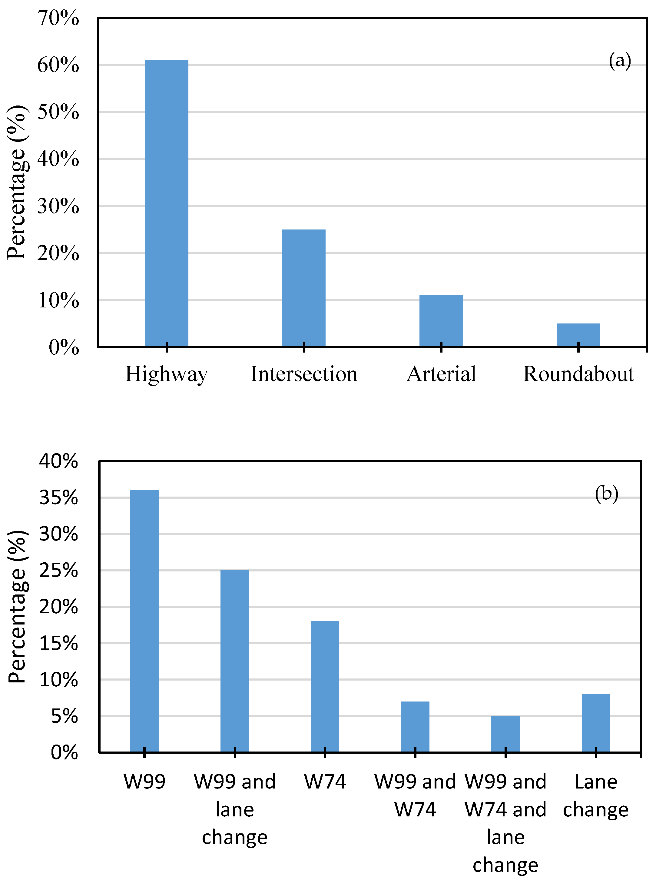
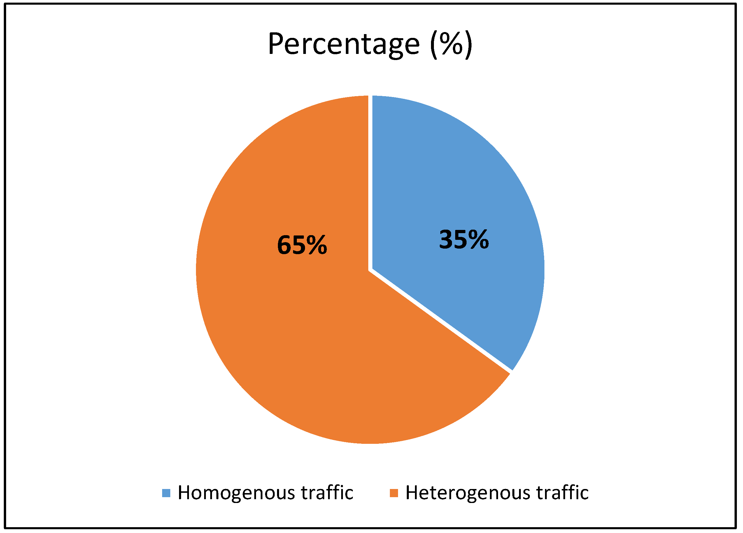
2. Literature Review on Different Parameters Used in PTV VISSIM Microsimulations

2.1. Mobility Impact of AVs

In comparison with other microsimulation platforms, VISSIM has been more widely used in assessing the influence of AVs on traffic flow at intersections, interchanges, and roundabouts using built-in models. According to recent research studies conducted using PTV VISSIM, AVs would help transport networks in several ways. These advantages include reduced traffic congestion, enhanced safety, better traffic flow, and greater traffic capacity for the existing road infrastructure [32,33]. Based on how the human driver and the vehicle technology coordinate the driving task, the Society of Automotive Engineers has divided automated cars into six levels of automation. As shown in Figure 4, in the first three levels, the primary driving tasks are performed by the human driver. Conversely, however, Levels 4 and 5 indicate total automation [34].
Park et al. [35] conducted research by defining 36 different scenarios in VISSIM encompassing diverse traffic volumes and AV penetration rates to examine how the behavior of Level 4 automated vehicles affects the traffic flow of urban roadways. According to their findings, AVs have an optimistic impact on traffic dynamics, lowering travel times and delays while improving vehicle speeds. As AV use increased, these traffic benefits became more noticeable. When AV penetration reached 100%, average travel time decreased by 17%, delays reduced by 31%, and vehicle speeds improved by 21%.
Aria et al. [36] used the PTV VISSIM internal model for automated cars to conduct a simulation study on an Autobahn sector with two scenarios: 100% AVs and 100% CVs. Based on previous research, they altered the speed distribution and driver behavior features in car-following and lane-changing models to simulate the presence of AVs. The results showed that AVs greatly improved traffic performance, particularly in congested areas. The AV situation raised average density by 8.09% during the evening peak hour, increased travel speed on the Autobahn by 8.48%, and resulted in a 9.00% decrease in travel speed. The specialty of modeling AVs is the basic differences in driving behavior, which require variable parameter values and often require unique features. This becomes particularly significant when assessing traffic safety.

2.2. Driving Behavior’s Impact on Safety

The type of vehicle, network characteristics, and driver behavior are three main components that have direct or indirect effects on road transport safety. Driving behavior, which includes a driver’s speed, acceleration, and gear selection, can have a substantial impact on traffic safety. The transport network’s performance is heavily influenced by driver behavior on a given route segment. Similarly, lateral and lane-changing habits have an important influence in determining driving behavior [37]. Driver behavior varies depending on traffic conditions, including free mobility, proximity to other vehicles, adherence to the car ahead, and deceleration [2]. In the last few years, a few studies have examined the safety impacts of connected and autonomous vehicles (CAVs) using the SSAM along with the VISSIM simulation software. Li et al. [38] utilized VISSIM simulation and the SSAM to examine the influence of AV fleets with different driving levels on traffic flow and safety in motorways. The VISSIM platform was used to study the driving behaviors of four AVs. According to the study, excessively cautious AVs could present new risks to the safety and efficacy of traffic. To examine the safety effects of connected and autonomous (CAV) penetration on the road network, Virdi et al. [39] developed a calibrated microsimulation environment in VISSIM. The SSAM was used for safety performance analysis. To simulate CAVs and evaluate their safety using microsimulation testing, this work employed VISSIM to develop a bespoke control algorithm. Morando et al. [32] used VISSIM microsimulation with the SSAM to evaluate the effects of AVs on safety at signalized intersections and roundabouts. VISSIM was used as a traffic microsimulation platform to simulate human-driven and autonomous vehicle behavior, analyzing probable conflicts based on TTC and PET. In this study, simulation was used to assess the AVs’ safety, addressing the lack of empirical evidence on their performance. Tibljas et al. [40] conducted a study to determine if the planned introduction of AVs will increase cyclist safety. The study employed VISSIM and the SSAM to analyze bicyclist behavior during peak hour traffic in the city center and investigate the possible advantages of AVs for their safety. This research was original in that it used VISSIM to simulate cars and bicycles sharing the same lane, which is common in city centers. The models were based on field data. Research by Fan et al. [19] and Zhou and Huang [20] showed that VISSIM and the SSAM may be applied to calculate the safety of a signalized intersection and that improving the simulation model may result in accurate traffic conflict estimates.

2.3. Effect of Weather

2.3.1. Impact of Weather and Driving Conditions on Driver Behavior

Unfavorable weather conditions that include precipitation, strong winds, low visibility, and extremely high or low temperatures can affect how people drive, notably in terms of speed selection and maintaining proper headway distances [41,42]. Ghasemzadeh et al. [43] examined the lane-keeping behavior of drivers in heavy rain by examining Florida and Washington highway traffic statistics from the Road Information Database (RID) and SHRP2 naturalistic driving study (NDS). They discovered that while there are more lane changes in clear weather than in heavy rain, there is also more variability in speed during heavy rain than in clear weather, which may indicate a higher safety risk. Additionally, they investigated the acceleration–deceleration behavior and found that while average deceleration was higher in clear weather, the range and average acceleration were larger under heavy rain. Data are evaluated either in real time or after they have been collected by software-based algorithms taught to detect objects. These methods aim to increase the accuracy and efficiency of object recognition on roads and streets while resolving safety issues. Vehicle-based investigation is a popular method, and subsequently it allows for rapid and effective object inspection. However, autonomous algorithms have always had trouble identifying things in bad weather, including rain, fog, snow, haze, storms, and poor lighting [44]. There are several negative impacts of the weather on traffic flow and transportation. Globally, rainfall happens 11.0% of the time on average [45]. According to studies [46], rainfall can unquestionably raise the risk of accidents by 70% when compared with normal weather. Furthermore, 76% of the world’s countries experience snowfall. For instance, according to U.S. national data, frozen slushy, slippery, or snowy roads account for 24% of weather-related vehicle accidents each year, while actively falling snow or snow combined with sleet accounts for 15%, underscoring the actual dangers of winter weather. Environmental factors such as fog, haze, sandstorms, and intense sunlight significantly impair visibility, which poses serious challenges for drivers [44].
During SHRP2 trips in clear and rainy weather, Mohamed M. Ahmed and Ali Ghasemzadeh [42] discovered a notable variation in driving habits and vehicle performance. Drivers reduced speeds by over five kilometers per hour below the permitted speed limit and kept longer headway lengths in both moderate and heavy rain. Weng et al. [47] assessed how a motorway in Beijing’s traffic flow changed with different snow levels. They concluded that, based on the volume of traffic, heavy snow reduces vehicle speed by 15% to 40%, with the average speed being roughly 28% slower than in clear weather. Furthermore, it was discovered that road capacity dropped by roughly 33% and that the headway time, the amount of time between vehicles, increased by two to four seconds. Druta et al. [48], who gathered weather-related collisions and near-collision incidents from the SHRP2 dataset, found that drivers are generally extra cautious when driving in snow than when it is raining. Khan et al. [41] evaluated how drivers chose their speeds in near and distant fog. They discovered that the average speed decreases more in near fog than in far fog, and that the average speed is significantly slower in foggy weather than in clear conditions.

2.3.2. Modeling Driving Behavior and Traffic Flow in a Variety of Weather Scenarios

Numerous studies have examined the damaging effects of unfavorable weather on road transportation and traffic flow variables (capability, free-flow speed, mean speed, and saturation flow rate); however, very few have made use of trajectory-level information from SHRP2-NDS [49,50] or driving simulators [51,52] to assess traffic flow in various driving situations and develop weather-dependent microsimulation models by carefully analyzing driver behaviors at the microscopic level. Some studies considered various weather conditions along with their respective intensities to calibrate lane-change and weather-dependent vehicle-following models in the PTV VISSIM, and researchers defined diverse adversity levels for each of these weather conditions [53,54]. Hammit et al. [53] used the SHRP2 NDS dataset to determine the ideal velocities and parameter values for the W99 model under various weather situations. Following baseline traffic flow situations, simulations of fog, snow, and rain (from very light to heavy) were conducted. When compared with clear sky conditions, VISSIM simulations revealed no differences in capacity between extremely light and light rain. However, under both moderate and heavy rain, the capacity improved. Speed improved by 22% in fog, very light rain, and light rain, but reduced by 11% in moderate rain, heavy rain, and snow. To assess traffic safety and operation in adverse weather, Anik Das and Mohamed M. Ahmed [54] determined that clear weather and two levels each of rain, snow, and fog were the seven weather scenarios for which the essential and free-lane-change variables were modified based on lane-change frequencies from the SHRP2 NDS. Weather-specific simulation results showed that the overall number of simulated conflicts, including rear-end and lane-change conflicts, increased in extremely bad weather, highlighting the detrimental effects of bad weather on driver performance and behavior.
In order to analyze traffic flow and road capacity, Chen et al. [55] constructed 11 distinct weather conditions in a driving simulator with three distinct traffic flow stages. These comprised two levels of snow, four levels of fog and of rain, and a clear-sky scenario. They suggested the optimum speed in each weather condition and all 10 parameters of the Wiedemann 99 car-following model (CC0–CC9) based on the data collected from the driving simulator. According to the simulation’s output, average speed decreased significantly in snowy conditions (19.2–45.6%), and in additional harsh weather circumstances (heavy rain, dense fog, and very heavy rain), average speed decreased noticeably (7.6–27.5%). In snowy conditions, lesser density has been recognized as the larger headway that vehicles often maintain to avoid rear-end collisions because of reduced visibility and road friction. Furthermore, under snow, the road capacity significantly decreased by 43.7% to 71.1%, and in other extreme weather conditions, it significantly decreased by 11.1% to 20.5%. Jiaqi Ma et al. [56] created three weather situations—normal/clear, snowy, and severe—to depict the different winter weather circumstances of Wyoming’s I-80 for a weather-responsive management system for connected vehicles. For each of the three weather scenarios, 10 parameters of the Wiedemann 99 model (CC0–CC9) in VISSIM were calibrated to simulate improving road conditions after snowplow vehicles were deployed at crucial roadway segments before adverse weather events. Golshan Khavas et al. [57] used loop sensor and meteorological information for I 694 in the Twin Cities, Minnesota, to calibrate nine key VISSIM input parameters for three weather scenarios (icy, dry, and wet) in order to evaluate the impact of unfavorable weather on traffic flow.

2.3.3. Modeling Speed Distribution of Vehicles Under Various Weather Situations

Along with updating traffic flow models, it is critical to add speed distribution into VISSIM to ensure correct calibration of microsimulation models and reflect the unique characteristics of traffic states under various weather situations [42]. A few publications [41,57] addressed the requirement to calibrate the speed distribution in order to simulate traffic flow during bad weather conditions. In the analysis of trajectory-level data on drivers’ speed selection in uncongested traffic under different weather conditions, Khan et al. [41] concluded that while vehicle speeds show a normal distribution in clear weather, they produce a clear Weibull distribution in adverse weather. The researchers chose the right speed distribution for four weather situations (rain, snow, fog, and clear) and found that drivers always slow down significantly in bad weather, with snow having the biggest effect. In a different investigation, Khan et al. [58] adjusted the distribution for two fog levels (near fog and far fog) and speeds in clear weather. According to the study, when compared with clear weather, speed fluctuations are greater in fog but reduced in near fog.

2.3.4. Performance of AVs Under Adverse Weather

AVs and automated driving systems (ADSs) are the most advanced automotive technologies. Despite the numerous benefits, perception and sensing for vehicles equipped with ADSs in unpredictable driving situations are a source of concern, preventing them from progressing to higher autonomy for a prolonged period. To address the immediate challenge of AVs’ ADSs performance in bad weather, a few studies have been conducted using computer simulations or rigorous testing in difficult conditions to concentrate on how AVs perceive and logically sense severe weather. A thorough literature review of the effects of unfavorable climate on advanced sensors, like LiDAR (light detection and ranging), GPS, cameras, and radar, was presented by Zang et al. [59]. They also described in detail how rainfall impacts automotive radar, considering both attenuation and backscatter effects. Song et al. [60] evaluated the ability of a multi-sensor system to identify dynamic barriers and road lanes in a three-dimensional (3D) environment under a variety of simulated weather conditions in the ALEAD digital environment. The researchers simulated these sensing technologies—image sensors, cameras, and infrared cameras—as well as LiDAR technology and examined their performance problems in rainy and foggy environments. According to Rasshofer and Gresseret [61], rainy weather significantly reduces autonomous cars’ capacity to track and avoid moving objects. The study emphasized how more advanced segmentation algorithms, such as deep learning methods, could be used to increase object recognition and tracking accuracy under these unfavorable weather conditions.
According to Zhang et al. [62], increasing perception was considered to be the best technique to lessen the adverse effects of unfavorable weather conditions, which necessitated a thorough evaluation of many machine learning and image processing approaches, including de-noising. The study also looked at other ways for improving sensing, such as classification and localization. The findings demonstrated a growing use of advanced networks, computer vision models, and robust sensor fusion. A thorough analysis revealed that improvements in test equipment and new LiDAR architectural technologies have significantly improved perception and sensing performance in typical wet weather conditions, with the recent improvement in rain and fog situations being primarily due to advances in computer vision. The study stated that future advancements to LiDAR technology are expected, emphasizing the significance of expanding datasets and developing perception enhancement methodologies to meet issues faced by snowy weather.

2.4. Rural Area and Safety Analysis

Small cities and rural areas frequently see mixed flow traffic, which deviates from lane markings. Both motorized and non-motorized vehicles contribute to mixed traffic flow. Non-motorized vehicles include bicycles, rickshaws that are pulled by hand, and carts pulled by animals. Cars, motorcycles, transport vehicles, bicycles, trucks, and auto-rickshaws are examples of motorized vehicles. The size, mobility, control systems, and stationary/moving characteristics of these vehicles vary. Traffic flow is not consistent; instead, there is a lot of lateral motion [3]. Analyzing vehicle-to-vehicle interactions and creating workable results are necessary to comprehend overcrowding and bottlenecks in diverse traffic. The conduct of drivers who follow other vehicles is replicated by car-following models. These models are frequently employed in capacity and safety assessments, in addition to the creation of traffic simulation models [63]. VISSIM’s ability to precisely simulate mixed traffic, including lane-changing, car-following, and lateral behaviors, sets it apart from other traffic flow simulation solutions [64]. Approximately 30% of interstate vehicle miles are driven on rural motorways, which have lower maximum speed limits and truck percentages. Due to the altered roadway environment, rural freeway work areas are characterized by heavy truck traffic and unpredictable vehicular behavior [65]. W 99 was given precedence for highways, with speed restrictions of 80 km/h and higher, while W 74 is appropriate for intersections, roundabouts, and arterials with speed limits under 80 km/h. Depending on the study methodology, lane modifications can be applied to both. Here, the priority was for W99 for rural and small city arterial roads. Jehn et al. [65] created and adjusted the generalizable microsimulation models in VISSIM for lane closures on rural motorways. The results suggested that different time headway distributions be made for trucks and passenger cars, and that the default anticipated acceleration for heavy-duty vehicles would be set between two and three feet per second. They suggested that integrated site capacity estimations with a range of geometric, traffic, and ecological variables may be obtained by extending the methodology provided. Table 2 shows some previous literature based on driver-behavior models in VISSIM software.
Table 3 shows the literature review on the utilization of different parameters like weather, rural or urban areas, mobility, and traffic flow in road networks. Huang et al. [74] concluded that snowy weather had the greatest impact on traffic flow. Fujiu et al. [75] demonstrate that the delay between OD intervals rises with the mixing rate of AVs. Khashayarfard and Nassiri [37] concluded that traffic flow will be lowered if AVs were present in traffic flow. Park et al. [69] suggested that traffic flows increase and delays decrease with an increase in AV penetration rate. Hammit et al. [53] observed that speed and density increase in snow, moderate rain, and heavy rain. Chen et al. [55] concluded that adverse weather affects traffic flow. Zhang et al. [62] proposed the sensor model, and the results showed that intense rains may decrease a millimeter-wave radar’s detection range by up to 55%. Khan et al. [58] studied how fog affected motorway speed selection. This study’s findings may help drivers choose their speeds more wisely in foggy situations, which could enhance some safety measures, such as variable speed restrictions. Morando et al. [32] illustrate that AVs improve safety through high penetration rates and reduce conflict at signalized intersections. Khavas et al. [57] proposed the model to calculate which VISSIM input parameters are most capable of generating a traffic stream related to the weather category. Ghasemzadeh et al. [58] found that, compared with drivers in clear weather, drivers in heavy rain are approximately 3.8 times more likely to have a higher average deviation of lane position. Fan et al. [19] observed that, after two stages of calibration, the mean absolute prevent error (MAPE) for all conflicts was found to have decreased from 78.1% to 33.4%.

2.5. Research Gaps Identified

Despite their strengths, the reliability of VISSIM and the SSAM has several limitations.

2.5.1. Lack of Real-World Validation of SSAM Results

To see whether the simulated traffic conflicts could be utilized to forecast real-world conflicts, linear regression analysis was carried out by Fan et al. [19]. Traffic conflicts are unpredictable and difficult for microscopic traffic simulation models to predict. The discrepancy among the observed and simulated conflicts suggests that the SSAM approach should be used carefully and only in situations when alternative safety evaluation techniques are not appropriate.
Table 4 shows that it is challenging to cross-validate the field observation of traffic conflict results because of the observational approach, and the definition of a dispute varies for various conventional methodologies. Furthermore, observers subjectively register conflicts whether recognizing conflicts by evasive actions or manually analyzing video recordings, and inter- and intra-observer variability pose a significant reliability issue [76]. The field study approach is costly and time-consuming.
Real-world traffic conflicts can be detected objectively and effectively using computer vision techniques. There have been early attempts to connect computer vision techniques to accident observations [17], and the development and use of these approaches is growing [77,78,79]. In the future, these methods have the capacity to greatly enhance the traditional drawbacks of observer-based traffic conflict strategies. Due to ethical and regulatory concerns, naturalistic driving information is safeguarded and not entirely accessible to the research community. Furthermore, because there is so much naturalistic driving information—it contains recordings covering years—extracting traffic conflicts from it is a challenging task. However, because some incidents featured no driver reaction and hence no notable kinematic changes, selecting occurrences based on kinematic triggers may potentially result in selection bias. Recording a collision by a participating vehicle is a risky prerequisite for validating traffic conflict methods that depend on naturalistic driving data. Because random drivers would be less inclined to take part in a thorough monitoring study of their own car, selection bias is another possible problem.
Table 4. Methods to collect traffic conflict used in previous study.
Method UsedAdvantageDisadvantage
Field study [76,80,81]Simple to use; more reliable than many other objective measurements.Variability among and across observers; high expense; labor-intensive.
Computer vision methods [77,78,79,82]Automatically identify traffic conflicts; economical; trustworthy; and effective.High standards for video quality; still in the early stages of development.
Driving in a naturalistic manner [83,84,85]Permits the investigation of uncommon safety scenarios, such as collision and conflict scenarios.Restricted data size: event sorting is time-consuming; data are safeguarded and not entirely accessible to the research community.

2.5.2. Inconsistencies in Weather Impact Modeling

A variety of weather scenarios within each condition category, the total number of trips that constitute each dataset, the particular drivers that are represented in each dataset, the degree of congestion, and other unidentified elements pertaining to the current driving environment, can influence the results in modeling [53]. The author concluded that a comprehensive dataset that encompasses a wide variety of circumstances is susceptible to overfitting. The effect of adverse weather can affect the AV sensors such as camera, LiDAR, and GPS. It is challenging to thoroughly evaluate the impact of weather circumstances, particularly the uncommon severe weather, on traffic flow characteristics because both weather and traffic conditions are unpredictable and nonrepeatable [55].

2.5.3. Limited Work on Mixed Traffic in Developing Countries

Garcia et al. [14] compared manual and automatic calibration techniques in VISSIM on an expressway in Chihuahua, Mexico. Asaithambi et al. [63] investigated the assessment of various vehicle-following models to determine which models were appropriate for mixed traffic situations. Field data were collected from Chennai, India. Huang et al. [74] evaluated AV mobility under adverse weather conditions on the five-lane arterial road in Saratoga Springs, Utah. Mou et al. [86] used T-LSTM to forecast traffic flow on Beijing’s East Fourth Ring Road between the Shibalidian Bridge and Hongyan Bridge. Weng et al. [47] studied the impact of snowy weather on the expressways in Beijing. Chen et al. used driving simulators on Beijing’s Ring Road (an urban motorway) between Zuoanmen Bridge and Xizhimen Bridge to assess the impact of bad weather on traffic flow characteristics. However, there is very little research available on the effect of weather and AVs’ driving behavior on mixed or heterogenous traffic flow in developing countries.

3. Discussion

The fundamental element of VISSIM microsimulation is driving behavior. Highways, which significantly affect traffic operations, were the subject of 60% of the investigation, as Figure 5a,b illustrates. W 99, on the other hand, was utilized by 36% since it contains metrics that show a thorough comprehension of the traffic situation. However, W 99 did not adequately depict traffic problems associated with unusual driving behavior, including forced driver movements that can cause conflict. VISSIM’s lane-change model identifies traffic features that lead to constant changes of lanes. There are issues with the W 99 lane-change model that must be resolved. Driving-behavior simulation could enhance the understanding of lane-change risk and result in more successful road safety programs on rural or small city roads or freeways.
VISSIM does not provide a model for lateral movement within a lane and cannot model two-dimensional traffic flow. In mixed traffic models, lower-speed vehicles often cause bottlenecks, which is uncommon in practice. Additionally, because vehicles in the simulation follow links and connectors, VISSIM cannot precisely simulate vehicle trajectories. Two opposing left-turn connectors can be programmed at a junction without overlap to reduce the likelihood of head-on collisions between left-turning cars. Furthermore, cars driving to the left occasionally deviate from lane lines and make broad or tight bends. To avoid biased SSAM results, these vehicle-turning radius uncertainties must be suitably handled by the simulation tools.
Huang et al. [74] investigated mobility under inclement weather using VISSIM. Unfavorable weather situations, like snowfall, dense fog, and rain, have a tremendous effect on traffic patterns and driving habits. Traffic flow is primarily affected by snowy conditions. Ansarinejad et al. [87] studied the effect of fog on vehicular emissions in mixed traffic flow with AVs and HVs using the VISSIM model. Driving in foggy conditions would have less of an adverse environmental impact if AVs were introduced into the conventional transportation network and their penetration rate was gradually increased. Figure 6a,b show that the average stops and delays in all weather conditions (snow, rain, heavy, dense fog, and clear) are gradually and steadily reduced as the AV penetration rate increases from 0% to 100%, with a fully autonomous network seeing the fewest stops, minimized delays, and enhanced traffic flow. This finding shows a direct correlation between AV use and a decrease in the frequency of stops, which holds true across different weather conditions, indicating that AVs can adapt and behave well in a variety of environmental challenges and are beneficial in reducing stops regardless of weather. The improvements in traffic flow, such as reduced stoppage frequency, diminished delays, and higher average speeds, can be directly credited to the distinct driving behavior of AVs, setting them apart from their human-driven counterparts. The average speed of vehicles increases in all weather circumstances when the proportion of AVs on the road increases steadily from 0% to 100%. When transitioning from 0% to 100% AVs, the most substantial improvement in average speed is observed during snowy weather, followed by heavy dense fog and then rain (Figure 6). Examining the data in Table 5 will allow us to provide a more detailed insight into the driving behavior of these new technologies. When compared with human-driven vehicles, AVs are perceived to be less cautious. They show faster recognition of other vehicles on the road and quicker reaction times when following them.
Traffic flow dynamics are determined by competitive traffic streams with different features that arise from different vehicle behaviors and driver preferences. In a multimodal system, for instance, vehicles, transit fleets, and trucks all share rights-of-way. Different travel lanes, desired speeds, and safety distances are needed for the various vehicle characteristics. Additionally, drivers might exhibit a variety of driving behaviors that can complicate traffic dynamics, like maintaining gaps when chasing a leading car, using brakes repeatedly, and changing lanes continuously. In the same way, real-world traffic flow frequently exhibits variation [88]. The main difference among homogeneous and heterogeneous traffic systems is that the former are mostly caused by the various operational and performance features of automobiles. Figure 7 demonstrates the use of homogenous and heterogenous traffic flows in VISSIM. About 65% of previous researchers used heterogenous traffic flow in VISSIM, while 35% of the literature is based on homogenous traffic flow.
Table 6 demonstrates the comparison between AVs and HVs modeled in VISSIM with default parameters. VISSIM’s Wiedemann 99 car-following model was used to model behavior of HVs using its default settings. Two different sets of AV parameters were taken from Atkins [89] and PTV [90]. More assertive behaviors are reflected in AV parameters, such as shorter safety distances (CC1 and CC2) and shorter standstill distances (CC0). As a result, AVs should have shorter gaps. AVs respond more sensitively to the acceleration or deceleration of the preceding vehicle when the levels of the positive following threshold (CC5) and negative following threshold (CC4) are less. CC6 is set to zero since AVs can precisely maintain the correct speed without oscillating. Because of linked car technologies, AVs can accelerate more aggressively (higher CC7 and CC8) and have more observed vehicles, claims Atkins [89]. The alteration of these factors should be able to represent the expected AV behaviors even though the precise behavior of AVs is still mostly unknown. Table 7 shows the comparison between AV and HV performance under different parameters. As compared with HVs, AV performance on traffic flow shows a decrease in delay, traffic congestion, and accidents, while an increase in speed and dependability of travel duration was observed. AVs can be used in various weather conditions and at any location, such as urban and rural highways. AVs can perform well in adverse weather conditions because of attached sensor equipment like cameras, LiDAR, and GPS. With HVs, driver distractions due to reading or using cellphones while driving is high. If HVs and AVs are used in mixed traffic flow conditions, the delay in original destination (OD) increases. The delay among OD intervals is then progressively lowered as the mixing rate surpasses a particular level [19].

4. Future Research Opportunities

4.1. VISSIM Integration with AI

VISSIM is an isolated system that is comparatively closed. External control algorithms frequently need traffic flow data to be inserted within the simulation system to improve the signal control settings and validate the research model. Nevertheless, VISSIM’s features usually fall short of this criterion. COM interface script files can be executed with VISSIM [90]. The COM interface module extension is used for postprocessing and data preparation. It efficiently oversees the scenario analysis process, which includes developing the control algorithm and retrieving and processing each network feature separately. Additionally, commands can be given to VISSIM via the COM interface, and the control program can be built in accordance with the project needs. It is acceptable to control traffic flow on each route and manipulate the traffic lights [91,92]. The evaluation of artificial intelligence (AI) performance, particularly deep learning ensemble-based models, is heavily impacted by uncertainty quantification (UQ). However, in addition to the need for multiple evaluations to track model instability, the use of UQ through current AI techniques is limited by changes to topology and optimization processes as well as computer resource constraints [93]. Traditional weight update methods of an artificial neural network (ANN) usually have trouble breaking out of local optima and show delayed convergence to ideal solutions [94]. This phenomenon, which results in a subsequent decrease in the predictive power of ANNs, is caused by using optimization techniques such as gradient descent. Researchers have recently suggested a variety of advanced machine learning models as workable substitutes for traffic forecasting. For instance, a stacked auto coder (SAE) and long short-term memory (LSTM) were created for road traffic prediction [95]. Mou et al. [86] used both simulated and real data from VISSIM to validate their suggested models. Temporal information improves the LSTM neural networks (T-LSTM) model, which takes temporal elements into account and acknowledges the importance of temporal data in traffic flow prediction. When compared with other standalone models, the model under examination exhibits greater accuracy. However, deep neural networks usually demand a lot of processing power, which poses challenges for embedded devices. The development of resource-efficient techniques has become crucial to effectively achieving these goals. Future studies should provide both quantitative and qualitative analysis with a strong emphasis on AI computational components. Studies should also include creating behavior prediction models for AVs that use machine learning and deep learning to predict what will happen to cars, pedestrians, and bicycles. These models will work well in inclement weather, enhancing AV decision-making for increased efficiency and safety

4.2. AVs in Heterogenous and Mixed Traffic Environments

Rios-Tores et al. [96] assessed and analyzed CAVs’ performance and impact on fuel usage in mixed traffic at different market penetration rates using VISSIM. They concluded that when the CAVs’ market penetration rates (MPR) surpass 40% in crowded situations, optimum coordination control offers the greatest advantage in terms of fuel efficiency and emissions reduction. Triber et al. [97] investigated how AVs affected mixed traffic. The degree to which the presence of AVs (particularly in platoons) alters the behavior of manually operated vehicles is still unknown. In addition to examining different road surface conditions, the longitudinal automation of vehicles in situations with and without mixed traffic (passenger cars, buses, and large trucks) was also examined by Ioannou et al. [98]. Regardless of the situation, capacity was decreased by between 30% and 40% in the study’s simulations when the road surface was wet. Additionally, dependent on the proportion of buses and heavy trucks, combining different vehicle classes reduced carrying capacity by 11% to 23%. Platooning produced the maximum capacity, particularly when combined with coordinated breaking. Capacity for 10-vehicle platoons reached 7489 vehicles per hour, a significant upsurge over regular traffic. The impact of Cooperative Adaptive Cruise Control (CACC) on mixed traffic flow stability was verified by Schakel et al. [99]. To ascertain the stability of traffic flow, they evaluated the shock wave dynamics using simulations. The study concluded that the stability of traffic flow was only marginally impacted by an increase in headway unpredictability brought on by mixed traffic.
Vandriel et al. [100] suggested that when 10% to 50% of the vehicles are operating automatically in traffic, traffic flow models indicate a 30% or 60% reduction in congestion delays due to increased traffic flow. It is possible that automated driving might decrease traffic by 50%. When vehicle-to-vehicle or vehicle-to-infrastructure communication is employed, this percentage may increase. However, the effect of automation on traffic flow may be greatly influenced by human factors. According to the theoretical framework, human factors have the potential to impact driving behavior [5] as well as system settings. Driving behavior in cars with varying degrees of automation may also be influenced by human factors. Only the automation of the longitudinal control task was considered in most of the recent research. It is necessary to conduct research that takes automated lateral control into account. Lastly, basic mathematical models of driving behavior have been the primary tool employed in simulation investigations. New models that can effectively represent this new realism should be built using the results of empirical investigations on the effect of automation on traffic flow efficiency, including behavioral changes.

4.3. Real-Time SSAM Integration with Live Traffic

The complex nature of real-world circumstances, such as unpredictable human behavior and shifting traffic patterns, can pose further difficulties not well represented in simulated datasets; hence, the simulation environments might not accurately represent real-world driving cases [44]. Implementing approaches using modern methods like computer vision and naturalistic driving has significant potential for creating extensive automated techniques for gathering data on traffic conflicts [26]. Another challenge is determining the validity of the SSAM. The variety of surrogate safety data that the SSAM can extract from comprehensive vehicle trajectory data cannot be gathered by manual (human observer) field investigations. Thus, new insights may be gained by applying the SSAM to the study of conflict events and real-world vehicle trajectory data. Additionally, real-world data for calibration could benefit the efforts to create a suitable composite. In addition to analyzing data from the real world, those data need to be gathered. Comprehensive vehicle trajectory data cannot be recorded by manual (human observer) research. Although more research and development are necessary, efforts to gather information from video image analysis are getting better. This is included as a distinct study direction because it is an ambitious endeavor in and of itself.

5. Conclusions

This study analyzed international studies and practical uses of PTV VISSIM and SSAM software. The study focused on driving behavior, AV performance, and traffic flow in adverse weather environments, as well as traffic safety in urban and rural areas. This literature review also covered recent research on the impact of AV integration on mobility, and the impact of driving behavior on safety in conjunction with the SSAM. Through evaluations, it was observed that the SSAM is the effective model to evaluate traffic safety in rural and small city traffic scenarios. According to this study, with its 10 parameters, the Wiedemann 99 driving behavior model provides a more detailed depiction of traffic field circumstances than the Wiedemann 74 model. One of VISSIM’s unique difficulties is dealing with situations like bad weather and traffic safety on rural or small city freeways. Despite VISSIM’s lack of incident simulation functionality, researchers investigated several approaches to overcome these problems.
An in-depth literature review on the impact of weather on AVs improves understanding of how mixed traffic flow with autonomous vehicles performs across a range of four real-world weather scenarios: clear sky, rain, snow, and heavy dense fog. The study of how weather impacts AVs can improve average speed, reduce frequency of stops, and decrease delay times, all of which subsequently enhances traffic efficiency. An important area of research is assessing and measuring the advantages and effects of CAVs utilizing mixed traffic scenarios, particularly in the interface between small cities and rural areas or freeways.
Although it has been acknowledged that the SSAM is the best tool for safety evaluation, the model has not been calibrated or validated using real-world data to determine realistic frequency values. Nonetheless, there has been apprehension regarding the precision of driver behaviors in the modeling, and it has been proposed that the problem may be resolved by enhancing the simulation model’s calibration. VISSIM merging with the SSAM across present applications may play a significant role in tackling complex issues like adverse weather conditions. To find the most important parameters in VISSIM, sensitive analysis can be used with the SSAM. To determine which characteristics have the greatest impact on vehicle conflicts, this method can be implemented by using vehicle conflicts as measures of effectiveness.
This study also recommends the adoption of real-time data integration, weather-responsive microsimulation calibration, and behavior-based AV parameter optimization. Key future research should prioritize developing dynamic traffic safety frameworks that incorporate sensor feedback, weather analytics, and machine learning into AV behavior modeling.

Author Contributions

Conceptualization, T.A., A.A., Y.H. and P.L.; methodology, T.A., Y.H. and P.L.; formal analysis, T.A., A.A., Y.H. and P.L.; investigation, T.A., A.A., Y.H. and P.L.; resources, Y.H. and P.L.; data curation, T.A.; writing—original draft preparation, T.A. and A.A.; writing—review and editing, T.A., A.A., Y.H. and P.L.; visualization, T.A. and A.A.; supervision, Y.H. and P.L.; project administration, Y.H. and P.L.; funding acquisition, Y.H. and P.L. All authors have read and agreed to the published version of the manuscript.

Funding

The work presented in this paper is conducted with the support from the Upper Great Plains Transportation Institution/North Dakota State University and the Center for Multi-Modal Mobility in Urban, Rural, and Tribal Areas (CMMM), a Tier 1 University Transportation Center funded by the U.S. Department of Transportation. The contents of this paper reflect the views of the authors, who are responsible for the facts and accuracy of the information presented.

Data Availability Statement

The data will be made available upon request.

Acknowledgments

This work was supported by the Upper Great Plains Transportation Institute at North Dakota State University and the Center for Multi-Modal Mobility in Urban, Rural, and Tribal Areas (CMMM), a Tier 1 University Transportation Center funded by the U.S. Department of Transportation. The authors gratefully acknowledge this support. The views expressed in this paper are those of the authors and do not necessarily reflect the official policies or positions of the sponsoring organizations. The authors are solely responsible for the content and the accuracy of the information presented herein.

Conflicts of Interest

The authors declare no conflicts of interest.

References

  1. WHO, Global Status Report on Road Safety 2023. 2023. Available online: https://www.who.int/publications/i/item/9789240086517 (accessed on 28 February 2025).
  2. Al-Msari, H.; Koting, S.; Ahmed, A.N.; El-shafie, A. Review of driving-behaviour simulation: VISSIM and artificial intelligence approach. Heliyon 2024, 10, e25936. [Google Scholar] [CrossRef]
  3. Khodayari, A.; Ghaffari, A.; Ameli, S.; Flahatgar, J. A historical review on lateral and longitudinal control of autonomous vehicle motions. In Proceedings of the ICMET 2010—2010 International Conference on Mechanical and Electrical Technology, Singapore, 10–12 September 2010; pp. 421–429. [Google Scholar] [CrossRef]
  4. Fagnant, D.J.; Kockelman, K.M. The travel and environmental implications of shared autonomous vehicles, using agent-based model scenarios. Transp. Res. Part C Emerg. Technol. 2014, 40, 1–13. [Google Scholar] [CrossRef]
  5. Hoogendoorn, R.; Van Arem, B.; Hoogendoorn, S. Automated driving, traffic flow efficiency, and human factors. Transportation Research Record. 2014, 2422, 113–120. [Google Scholar] [CrossRef]
  6. Campbell, M.; Egerstedt, M.; How, J.P.; Murray, R.M. Autonomous driving in urban environments: Approaches, lessons and challenges. Philos. Trans. R. Soc. A Math. Phys. Eng. Sci. 2010, 368, 4649–4672. [Google Scholar] [CrossRef]
  7. Howard, A. Real-Time Stereo Visual Odometry for Autonomous Ground Vehicles. Available online: https://www-robotics.jpl.nasa.gov/media/documents/howard_iros08_visodom.pdf (accessed on 2 March 2025).
  8. How, J.P.; Bethke, B.; Frank, A.; Dale, D.; Vian, J. Real-Time Indoor Autonomous Vehicle Test Environment. IEEE Control Syst. 2008, 28, 51–64. [Google Scholar] [CrossRef]
  9. Kuwata, Y.; Teo, J.; Fiore, G.; Karaman, S.; Frazzoli, E.; How, J.P. Real-time motion planning with applications to autonomous urban driving. IEEE Trans. Control Syst. Technol. 2009, 17, 1105–1118. [Google Scholar] [CrossRef]
  10. Keymasi, A.; Ali, K.S. Dynamic modeling and tracking control of a car with n trailers. Multibody Syst. Dyn. 2016, 37, 211–225. [Google Scholar] [CrossRef]
  11. Le, S.; Zolfaghari, A.; Polak, J. Autonomous cars: The tension between occupant experience and intersection capacity. Transp. Res. Part C. 2015, 52, 1–14. [Google Scholar] [CrossRef]
  12. Michael, J.B.; Godbole, D.N.; Lygeros, J.; Sengupta, R. Capacity Analysis of Traffic Flow Over a Single-Lane Automated Highway System. J. Intell. Transp. Syst. 1998, 4, 49–80. [Google Scholar] [CrossRef]
  13. Basak, C.; Hetu, S.N.; Li, Z.; Azevedo, C.L.; Loganathan, H.; Toledo, T.; Xu, R.; Xu, Y.; Peh, L.; Ben-akiva, M. Modeling Reaction Time within a Traffic Simulation Model. In Proceedings of the 16th International IEEE Conference on Intelligent Transportation Systems (ITSC 2013), The Hague, The Netherlands, 6–9 October 2013. [Google Scholar] [CrossRef]
  14. Espejel-Garcia, D.; Saniger-Alba, J.A.; Wenglas-Lara, G.; Espejel-Garcia, V.V.; Villalobos-Aragon, A. A Comparison among Manual and Automatic Calibration Methods in VISSIM in an Expressway (Chihuahua, Mexico). Open J. Civ. Eng. 2017, 07, 539–552. [Google Scholar] [CrossRef]
  15. Prakash, A.; Ravinder, R.; Vittalaiah, A.; Munipally, S.K.; Al-Farouni, M.H. VISSIM Based Traffic Flow Simulation Analysis on Road Network. E3S Web Conf. 2024, 529, 3009. [Google Scholar] [CrossRef]
  16. Hill, M.; Pittenger, J.; Ceifetz, A. Development of a Michigan-Specific VISSIM Protocol for Submissions of VISSIM Modeling.” Final Report SPR-1689 Michigan Department of Transportation. 2020. Available online: https://www.michigan.gov/mdot/-/media/Project/Websites/MDOT/Programs/Research-Administration/Final-Reports/SPR-1689-Report.pdf (accessed on 4 March 2025).
  17. Saunier, N.; Sayed, T.; Lim, C. Probabilistic collision prediction for vision-based automated road safety analysis. In Proceedings of the 2007 IEEE Intelligent Transportation Systems Conference, Bellevue, WA, USA, 30 September–3 October 2007; pp. 872–878. [Google Scholar] [CrossRef]
  18. Tarko, A.P.; Songchitruksa, P. Estimating the Frequency of Crashes as Extreme Traffic Events. In Proceedings of the 84th Annual Meeting Transportation Research Board, Washington, DC, USA, 9–13 January 2005; Available online: https://www.researchgate.net/publication/228572277_Estimating_the_frequency_of_crashes_as_extreme_traffic_events (accessed on 10 March 2025).
  19. Fan, R.; Yu, H.; Liu, P.; Wang, W. Using VISSIM simulation model and Surrogate Safety Assessment Model for estimating field measured traffic conflicts at freeway merge areas. IET Intell. Transp. Syst. 2013, 7, 68–77. [Google Scholar] [CrossRef]
  20. Huang, F.; Liu, P.; Yu, H.; Wang, W. Identifying if VISSIM simulation model and SSAM provide reasonable estimates for field measured traffic conflicts at signalized intersections. Accid. Anal. Prev. 2013, 50, 1014–1024. [Google Scholar] [CrossRef] [PubMed]
  21. Rahman, M.S.; Abdel-Aty, M.; Lee, J.; Rahman, M.H. Safety benefits of arterials’ crash risk under connected and automated vehicles. Transp. Res. Part C Emerg. Technol. 2019, 100, 354–371. [Google Scholar] [CrossRef]
  22. Gettman, D.; Pu, L.; Sayed, T.; Shelby, S. Surrogate Safety Assessment Model and Validation: Final Report. Publ. No. FHWA-HRT-08-051. 2008, 1–324. Available online: https://www.fhwa.dot.gov/publications/research/safety/08051/08051.pdf (accessed on 7 March 2025).
  23. Sha, H. Investigating the System-Level Performance of Connected and Autonomous Vehicles Against Transport and Broader Societal Impacts. Ph.D. Thesis, Loughborough University, Loughborough, UK, 2021. [Google Scholar] [CrossRef]
  24. Fyfe, M.R.W. Safety Evaluation of Connected Vehicle Applications Using Micro-Simulation. Postdoctorate Thesis, University of British Columbia, Vancouver, BC, Canada, 2014. [Google Scholar] [CrossRef]
  25. Wang, C.; Stamatiadis, N. Evaluation of a simulation-based surrogate safety metric. Accid. Anal. Prev. 2014, 71, 82–92. [Google Scholar] [CrossRef]
  26. Zheng, L.; Ismail, K.; Meng, X. Traffic conflict techniques for road safety analysis: Open questions and some insights. Can. J. Civ. Eng. 2014, 41, 633–641. [Google Scholar] [CrossRef]
  27. Gettman, D.; Head, L. Surrogate Safety Measures from Traffic Simulation Models, Final Report; FWHA-RD-2003 Office of Safety Research and Development, Turner-Fairbank Highway Research Center: McLean, VA, USA, 2003; Volume 3, pp. 487–4650. Available online: https://ntlrepository.blob.core.windows.net/lib/38000/38000/38015/FHWA-RD-03-050.pdf (accessed on 11 March 2025).
  28. Quddus, M. Exploring the Relationship Between Average Speed, Speed Variation, and Accident Rates Using Spatial Statistical Models and GIS. J. Transp. Saf. Secur. 2013, 5, 27–45. [Google Scholar] [CrossRef]
  29. Bulla-Cruz, L.A.; Laureshyn, A.; Lyons, L. Event-based road safety assessment: A novel approach towards risk microsimulation in roundabouts. Measurement 2020, 165, 108192. [Google Scholar] [CrossRef]
  30. Svensson, Å.; Hydén, C. Estimating the severity of safety related behaviour. Accid. Anal. Prev. 2006, 38, 379–385. [Google Scholar] [CrossRef]
  31. Guo, Y.; Essa, M.; Sayed, T.; Haque, M.M.; Washington, S. A comparison between simulated and field-measured conflicts for safety assessment of signalized intersections in Australia. Transp. Res. Part C Emerg. Technol. 2019, 101, 96–110. [Google Scholar] [CrossRef]
  32. Morando, M.M.; Tian, Q.; Truong, L.T.; Vu, H.L. Studying the Safety Impact of Autonomous Vehicles Using Simulation-Based Surrogate Safety Measures. J. Adv. Transp. 2018, 2018, 6135183. [Google Scholar] [CrossRef]
  33. Boualam, O.; Borsos, A.; Koren, C.; Nagy, V. Impact of Autonomous Vehicles on Roundabout Capacity. Sustainability 2022, 14, 2203. [Google Scholar] [CrossRef]
  34. Surface Vehicle Recommended Practice J3016; Taxonomy and Definitions for Terms Related to on-Road Motor Vehicle Automated Driving Systems. SAE International: New York, NY, USA, 2021. Available online: https://www.sae.org/standards/content/j3016_202104/%0Ahttps://cir.nii.ac.jp/crid/1370861704794099599.bib?lang=en (accessed on 14 May 2025).
  35. Park, J.E.; Byun, W.; Kim, Y.; Ahn, H.; Shin, D.K. The Impact of Automated Vehicles on Traffic Flow and Road Capacity on Urban Road Networks. J. Adv. Transp. 2021, 2021, 8404951. [Google Scholar] [CrossRef]
  36. Aria, E.; Olstam, J.; Schwietering, C. Investigation of Automated Vehicle Effects on Driver’s Behavior and Traffic Performance. Transp. Res. Procedia 2016, 15, 761–770. [Google Scholar] [CrossRef]
  37. Khashayarfard, M.; Nassiri, H. Studying the Simultaneous Effect of Autonomous Vehicles and Distracted Driving on Safety at Unsignalized Intersections. J. Adv. Transp. 2021, 2021, 6677010. [Google Scholar] [CrossRef]
  38. Li, S.; Sui, P.C.; Xiao, J.; Chahine, R. Policy formulation for highly automated vehicles: Emerging importance, research frontiers and insights. Transp. Res. Part A Policy Pract. 2019, 124, 573–586. [Google Scholar] [CrossRef]
  39. Virdi, N.; Grzybowska, H.; Waller, S.T.; Dixit, V. A safety assessment of mixed fleets with Connected and Autonomous Vehicles using the Surrogate Safety Assessment Module. Accid. Anal. Prev. 2019, 131, 95–111. [Google Scholar] [CrossRef]
  40. Tibljaš, A.D.; Giuffrè, T.; Surdonja, S.; Trubia, S. Introduction of Autonomous Vehicles: Roundabouts design and safety performance evaluation. Sustainability 2018, 10, 1060. [Google Scholar] [CrossRef]
  41. Khan, N.; Das, A.; Ahmed, M.M. Non-Parametric Association Rules Mining and Parametric Ordinal Logistic Regression for an In-Depth Investigation of Driver Speed Selection Behavior in Adverse Weather using SHRP2 Naturalistic Driving Study Data. Transp. Res. Rec. 2020, 2674, 101–119. [Google Scholar] [CrossRef]
  42. Ahmed, M.M.; Ghasemzadeh, A. The impacts of heavy rain on speed and headway Behaviors: An investigation using the SHRP2 naturalistic driving study data. Transp. Res. Part C Emerg. Technol. 2018, 91, 371–384. [Google Scholar] [CrossRef]
  43. Ghasemzadeh, A.; Ahmed, M.M. Drivers’ lane-keeping ability in heavy rain: Preliminary investigation using SHRP 2 naturalistic driving study data. Transp. Res. Rec. 2017, 2663, 99–108. [Google Scholar] [CrossRef]
  44. Tahir, N.U.A.; Zhang, Z.; Asim, M.; Chen, J.; ELAffendi, M. Object Detection in Autonomous Vehicles under Adverse Weather: A Review of Traditional and Deep Learning Approaches. Algorithms 2024, 17, 103. [Google Scholar] [CrossRef]
  45. Trenberth, K.E.; Zhang, Y. How often does it really rain? Bull. Am. Meteorol. Soc. 2018, 99, 289–298. [Google Scholar] [CrossRef]
  46. Andrey, J.; Yagar, S. A temporal analysis of rain-related crash risk. Accid. Anal. Prev. 1993, 25, 465–472. [Google Scholar] [CrossRef]
  47. Weng, J.; Liu, L.; Rong, J. Impacts of snowy weather conditions on expressway traffic flow characteristics. Discret. Dyn. Nat. Soc. 2013, 2013, 791743. [Google Scholar] [CrossRef]
  48. Druta, C.; Kassing, A.; Gibbons, R.; Alden, V.A. Assessing driver behavior using shrp2 adverse weather data. J. Safety Res. 2020, 73, 283–295. [Google Scholar] [CrossRef]
  49. Sun, H.; Zhang, W.; Yu, R.; Zhang, Y. Motion Planning for Mobile Robots—Focusing on Deep Reinforcement Learning: A Systematic Review. IEEE Access 2021, 9, 69061–69081. [Google Scholar] [CrossRef]
  50. Geiger, A.; Lenz, P.; Stiller, C.; Urtasun, R. Vision meets robotics: The KITTI dataset. Int. J. Rob. Res. 2013, 32, 1231–1237. [Google Scholar] [CrossRef]
  51. Sakaridis, C.; Dai, D.; Van Gool, L. ACDC: The Adverse Conditions Dataset with Correspondences for Semantic Driving Scene Understanding. In Proceedings of the IEEE/CVF International Conference on Computer Vision (ICCV), Montreal, QC, Canada, 10–17 October 2021; pp. 10745–10755. [Google Scholar] [CrossRef]
  52. Geyer, J.; Kassahun, Y.; Mahmudi, M.; Ricou, X.; Durgesh, R.; Chung, A.S.; Hauswald, L.; Pham, V.H.; Mühlegg, M.; Dorn, S.; et al. A2D2: Audi Autonomous Driving Dataset. arXiv 2020, arXiv:2004.06320. Available online: http://arxiv.org/abs/2004.06320 (accessed on 13 March 2025).
  53. Hammit, B.E.; James, R.; Ahmed, M.; Young, R. Toward the Development of Weather-Dependent Microsimulation Models. Transp. Res. Rec. 2019, 2673, 143–156. [Google Scholar] [CrossRef]
  54. Das, A.; Ahmed, M.M. Adjustment of key lane change parameters to develop microsimulation models for representative assessment of safety and operational impacts of adverse weather using SHRP2 naturalistic driving data. J. Safety Res. 2022, 81, 9–20. [Google Scholar] [CrossRef] [PubMed]
  55. Chen, C.; Zhao, X.; Liu, H.; Ren, G.; Zhang, Y.; Liu, X. Assessing the influence of adverse weather on traffic flow characteristics using a driving simulator and VISSIM. Sustainability 2019, 11, 830. [Google Scholar] [CrossRef]
  56. Ma, J.; Mahmassani, H.; Garrett, J.K.G.; Kim, E.; Neuner, N. Implementation of Analysis, Modeling, and Simulation Tools for Road Weather Connected Vehicle Applications; United States. Department of Transportation. Federal Highway Administration. Office of Operations: Washington, DC, USA, 2020; pp. 1–5. Available online: https://rosap.ntl.bts.gov/view/dot/57285 (accessed on 13 March 2025).
  57. Khavas, R.G.; Hellinga, B.; Masouleh, A.Z. Identifying parameters for microsimulation modeling of traffic in inclement weather. Transp. Res. Rec. 2017, 2613, 52–60. [Google Scholar] [CrossRef]
  58. Khan, M.N.; Ghasemzadeh, A.; Ahmed, M.M. Investigating the impact of fog on freeway speed selection using the SHRP2 naturalistic driving study data. Transp. Res. Rec. 2018, 2672, 93–104. [Google Scholar] [CrossRef]
  59. Zang, S.; Ding, M.; Smith, D.; Tyler, P.; Rakotoarivelo, T.; Kaafar, M.A. The impact of adverse weather conditions on autonomous vehicles: How rain, snow, fog, and hail affect the performance of a self-driving car. IEEE Veh. Technol. Mag. 2019, 14, 103–111. [Google Scholar] [CrossRef]
  60. Song, R.; Wetherall, J.; Maskell, S.; Ralph, J.F. Weather effects on obstacle detection for autonomous car. In Proceedings of the 6th International Conference on Vehicle Technology and Intelligent Transport Systems (VEHITS 2020), Prague, Czech Republic, 2–4 May 2020; pp. 31–341. [Google Scholar] [CrossRef]
  61. Rasshofer, R.H.; Gresser, K. Automotive Radar and Lidar Systems for Next Generation Driver Assistance Functions. Adv. Radio Sci. 2005, 3, 205–209. [Google Scholar] [CrossRef]
  62. Zhang, Y.; Carballo, A.; Yang, H.; Takeda, K. Perception and sensing for autonomous vehicles under adverse weather conditions: A survey. ISPRS J. Photogramm. Remote Sens. 2023, 196, 146–177. [Google Scholar] [CrossRef]
  63. Asaithambi, G.; Kanagaraj, V.; Srinivasan, K.K. Sivanandan, “Study of traffic flow characteristics using different vehicle-following models under mixed traffic conditions. Transp. Lett. 2018, 10, 92–103. [Google Scholar] [CrossRef]
  64. Mohan, R.; Eldhose, S.; Manoharan, G. Correction to: Network-Level Heterogeneous Traffic Flow Modelling in VISSIM. Transp. Dev. Econ. 2021, 7, 1. [Google Scholar] [CrossRef]
  65. Jehn, N.L.; Turochy, R.E. Calibration of Vissim Models for Rural Freeway Lane Closures: Novel Approach to the Modification of Key Parameters. Transp. Res. Rec. 2019, 2673, 574–583. [Google Scholar] [CrossRef]
  66. Farooq, D.; Juhasz, J. Simulation-Based Analysis of the Effect of Significant Traffic Parameters on Lane Changing for Driving Logic “Cautious” on a Freeway. Sustainability 2019, 11, 5976. [Google Scholar] [CrossRef]
  67. Lee, S.M.; Shokri, A.A.; Al-Mansour, A.I. Evaluation of the Applicability of the Ramp Metering to a Freeway Using Microsimulation: A Case Study in Riyadh, Saudi Arabia. Appl. Sci. 2019, 9, 4406. [Google Scholar] [CrossRef]
  68. Anil, R.; Satyakumar, M.; Jayakumar, J. Travel Time Estimation and Routing for Emergency Vehicles under Indian Conditions. In Proceedings of the 2018 3rd IEEE International Conference on Intelligent Transportation Engineering (ICITE), Singapore, 3–5 September 2018; pp. 247–252. [Google Scholar] [CrossRef]
  69. Park, S.; Oh, C.; Kim, Y.; Choi, S.; Park, S. Understanding impacts of aggressive driving on freeway safety and mobility: A multi-agent driving simulation approach. Transp. Res. Part F Traffic Psychol. Behav. 2019, 64, 377–387. [Google Scholar] [CrossRef]
  70. Anagnostopoulos, A.; Kehagia, F. CAVs and roundabouts: Research on traffic impacts and design elements. Transp. Res. Procedia 2020, 49, 83–94. [Google Scholar] [CrossRef]
  71. Raju, N.; Arkatkar, S.; Joshi, G. Evaluating performance of selected vehicle following models using trajectory data under mixed traffic conditions. J. Intell. Transp. Syst. Technol. Plan. Oper. 2020, 24, 617–634. [Google Scholar] [CrossRef]
  72. Weyland, C.M.; Baumann, M.V.; Buck, H.S.; Vortisch, P. Parameters Influencing Lane Flow Distribution on Multilane Freeways in PTV Vissim. Procedia Comput. Sci. 2021, 184, 453–460. [Google Scholar] [CrossRef]
  73. Lu, C.; Dong, J.; Houchin, A.; Liu, C. Incorporating the standstill distance and time headway distributions into freeway car-following models and an application to estimating freeway travel time reliability. J. Intell. Transp. Syst. Technol. Plan. Oper. 2021, 25, 21–40. [Google Scholar] [CrossRef]
  74. Huang, Y.; Ansarinejad, M.; Lu, P. Assessing Mobility under Inclement Weather Using VISSIM Microsimulation—A Case Study in U.S. In Proceedings of the 9th International Conference on Civil Structural and Transportation Engineering (ICCSTE’24), Toronto, ON, Canada, 12–16 June 2024; pp. 1–6. [Google Scholar] [CrossRef]
  75. Fujiu, M.; Morisaki, Y.; Takayama, J. Impact of Autonomous Vehicles on Traffic Flow in Rural and Urban Areas Using a Traffic Flow Simulator. Sustainability 2024, 16, 658. [Google Scholar] [CrossRef]
  76. Glauz, W.D.; Migletz, D.J. Application of Traffic Conflict Analysis at Intersections; Transportation Research Board: Washington, DC, USA, 1980. [Google Scholar]
  77. Ismail, K.; Sayed, T.; Saunier, N. Methodologies for aggregating indicators of traffic conflict. Transp. Res. Rec. 2011, 2237, 10–19. [Google Scholar] [CrossRef]
  78. Autey, J.; Sayed, T.; Zaki, M.H. Safety evaluation of right-turn smart channels using automated traffic conflict analysis. Accid. Anal. Prev. 2012, 45, 120–130. [Google Scholar] [CrossRef]
  79. Sayed, T.; Zaki, M.H.; Autey, J. Automated safety diagnosis of vehicle-bicycle interactions using computer vision analysis. Saf. Sci. 2013, 59, 163–172. [Google Scholar] [CrossRef]
  80. Hauer, E. Design Considerations of Traffic Conflict Surveys. Transp. Res. Rec. 1978, 667, 57–66. [Google Scholar]
  81. Almqvist, S.; Ekman, L. The Swedish Traffic Conflict Technique Observer’s Manual; Lund University: Lund, Sweden, 2001; pp. 1–4. [Google Scholar]
  82. Sayed, T.; Ismail, K.; Zaki, M.; Autey, J. Feasibility of computer vision-based safety evaluations. Transp. Res. Rec. 2012, 2280, 18–27. [Google Scholar] [CrossRef]
  83. Bagdadi, O. Assessing safety critical braking events in naturalistic driving studies. Transp. Res. Part F Traffic Psychol. Behav. 2013, 16, 117–126. [Google Scholar] [CrossRef]
  84. Dozza, M.; González, N.P. Recognising safety critical events: Can automatic video processing improve naturalistic data analyses? Accid. Anal. Prev. 2013, 60, 298–304. [Google Scholar] [CrossRef]
  85. Jonasson, J.K.; Rootzén, H. Internal validation of near-crashes in naturalistic driving studies: A continuous and multivariate approach. Accid. Anal. Prev. 2014, 62, 102–109. [Google Scholar] [CrossRef]
  86. Mou, L.; Zhao, P.; Xie, H.; Chen, Y. T-LSTM: A long short-term memory neural network enhanced by temporal information for traffic flow prediction. IEEE Access 2019, 7, 98053–98060. [Google Scholar] [CrossRef]
  87. Ansarinejad, M.; Huang, Y.; Qiu, A. Impact of Fog on Vehicular Emissions and Fuel Consumption in a Mixed Traffic Flow with Autonomous Vehicles (AVs) and Human-Driven Vehicles Using VISSIM Microsimulation Model. In Proceedings of the International Conference on Transportation and Development, Austin, TX, USA, 14–17 June 2023; pp. 253–262. [Google Scholar] [CrossRef]
  88. Jin, W.L. On the stability of stationary states in general road networks. Transp. Res. Part B Methodol. 2017, 98, 42–61. [Google Scholar] [CrossRef]
  89. Atkins, W.S. Research on the Impacts of Connected and Autonomous Vehicles (CAVs) on Traffic Flow. Stage 2: Traffic Modelling and Analysis Technical Report. 2016, 58p. Available online: https://www.gov.uk/government/uploads/system/uploads/attachment_data/file/530091/impacts-of-connected-and-autonomous-vehicles-on-traffic-flow-summary-report.pdf (accessed on 17 March 2025).
  90. Group, P. PTV VISSIM 2022 User Manual, Kaos GL Derg. 2022, pp. 265–297. Available online: https://www.scribd.com/document/552306439/Vissim-2022-Manual-246-400 (accessed on 17 March 2025).
  91. Cao, J.L.H. Research on VISSIM-MATLAB Integrated Traffic Simulation Platform Based on COM Interface TechnologyIn 2019. In Proceedings of the IEEE 3rd Information Technology, Networking, Electronic and Automation Control Conference (ITNEC), Chengdu, China, 15–17 March 2019; pp. 305–309. [Google Scholar] [CrossRef]
  92. Istiqomah, N.; Qidun, M.B.S. Traffic Simulation in an Intersection by Using Integrated Vissim-MATLAB. In Proceedings of the 2018 International Conference on Sustainable Energy Engineering and Application (ICSEEA), Tangerang, Indonesia, 1–2 November 2019; pp. 122–127. [Google Scholar] [CrossRef]
  93. Shahri, A.A.; Shan, C.; Larsson, S. A Novel Approach to Uncertainty Quantification in Groundwater Table Modeling by Automated Predictive Deep Learning. Nat. Resour. Res. 2022, 31, 1351–1373. [Google Scholar] [CrossRef]
  94. Kushwah, R.; Kaushik, M.; Chugh, K. A modified whale optimization algorithm to overcome delayed convergence in artificial neural networks. Soft Comput. 2021, 25, 10275–10286. [Google Scholar] [CrossRef]
  95. Sroczyński, A.; Czyżewski, A. Road traffic can be predicted by machine learning equally effectively as by complex microscopic model. Sci. Rep. 2023, 13, 14523. [Google Scholar] [CrossRef] [PubMed]
  96. Rios-Torres, J.; Khattak, Z.; Han, J.; Wang, C.; Lim, H. Assessing the Implications of Automated Merging Control in a Mixed and Heterogeneous Traffic Environment. In Proceedings of the 2021 IEEE International Intelligent Transportation Systems Conference (ITSC), Indianapolis, IN, USA, 19–22 September 2021; pp. 1098–1104. [Google Scholar] [CrossRef]
  97. Treiber, M.; Hennecke, A.; Helbing, D. Congested traffic states in empirical observations and microscopic simulations. Phys. Rev. E—Stat. Phys. Plasmas Fluids Relat. Interdiscip. Top. 2000, 62, 1805–1824. [Google Scholar] [CrossRef] [PubMed]
  98. Ioannou, P.A. Automated Highway Systems. 1997. Available online: https://link.springer.com/book/10.1007/978-1-4757-4573-3 (accessed on 2 April 2025).
  99. Schakel, W.J.; Van Arem, B.; Netten, B.D. Effects of cooperative adaptive cruise control on traffic flow stability. In Proceedings of the 13th International IEEE Conference on Intelligent Transportation Systems, Funchal, Portugal, 19–22 September 2010; pp. 759–764. [Google Scholar] [CrossRef]
  100. Van Driel, C.J.G.; Van Arem, B. The impact of a congestion assistant on traffic flow efficiency and safety in congested traffic caused by a lane drop. J. Intell. Transp. Syst. Technol. Plan. Oper. 2010, 14, 197–208. [Google Scholar] [CrossRef]
Figure 1. Concept of the SSAM.
Electronics 14 02046 g001
Figure 2. The most common SSMs derived from traffic microsimulation and their definitions.
Electronics 14 02046 g002
Figure 3. The SSAM conflict analysis tool and VISSIM simulation software workflow.
Electronics 14 02046 g003
Figure 4. Classification of automated cars into six levels of automation.
Electronics 14 02046 g004
Figure 5. (a,b). Use of VISSIM software in driving-behavior models in the previous literature.
Electronics 14 02046 g005
Figure 6. Various levels of automated vehicle adoption under clear sky, rain, heavy dense fog, and snow with (a) 50% and (b) 100% penetration rate.
Electronics 14 02046 g006
Figure 7. Use of homogenous and heterogenous traffic flow parameters in VISSIM in previous literature.
Electronics 14 02046 g007
Table 1. Wiedemann 99 vehicle parameter (CC0–CC9).
Parameter DescriptionImpact
CC0Distance at standstillInfluences minimum spacing between vehicles
CC1Headway timeHigher values imply more cautious following behavior
CC2Following variationAffects longitudinal oscillation in vehicle movement
CC3Threshold for entering followingDetermines perception–reaction threshold
CC4Negative following thresholdDefines lower bound of speed difference for following
CC5Positive following thresholdDefines upper bound of speed difference for following
CC6Speed dependency of oscillationHigher values cause greater speed oscillation
CC7Oscillation accelerationIndicates acceleration during oscillatory movements
CC8Standstill accelerationAcceleration from stationary state
CC9Acceleration at 80 km/hDesired acceleration at higher speeds
Table 2. Review of previous literature on driver behavior models in VISSIM software.
AuthorVISSIM ModelGeometryImportant Conclusions
[37]W99 and lane changeIntersectionExamining how AVs may affect potential conflicts. There will be substantial safety improvements from AVs.
The rate of collisions was found to have decreased.
The network is safer when there are more AVs installed.
[66]W 99
and lane change
FreewayExamining the impact of traffic characteristics on lane change for safety. Setting an immense speed dispersion results in more frequent lane changes, while a small speed distribution results in fewer lane changes.
[67]W 99
and lane change
FreewayInvestigating the application of ramp metering (RM) on a highway.
The average wait time was most successfully decreased by the signal on the ramp with the shortest red time.
The metering rate on highways is influenced by traffic conditions, and this strategy improved average speed the most.
[32]W99Intersections and roundaboutsThe impacts of AV on safety are assessed through simulation. With
increased penetration, AVs greatly improve safety.
[68]W74ArterialPredicting emergency vehicle (EV) routes and travel times. Calibration and validation considerably improved the accuracy of travel time estimation.
EVs’ limited mobility necessitated a more dynamic PCU at high flow rates.
[69]W 99FreewayConsiderate consequences of aggressive driving. Close following, abrupt lane changes, and quick deceleration are examples of destructive driving that raises the possibility of an accident with another car.
[70]W 99
and lane change
IntersectionDetermining different CAV penetration rates. Significant increases in safety are among the advantages of raising CAV penetration rates in traffic flow.
[71]W 99
and
W 74
RoadwaySimulated vehicle behavior in mixed traffic conditions. The trajectories show that the hysteresis phenomenon occurs among vehicles even under mixed traffic conditions. The technique of replicating high-speed roads with W 99 models and urban roads with W 74 models is severely opposed by the study. According to the study’s findings, both theories are very consistent.
[72]W 99
and
W 74
and lane change
FreewayExamined how traffic flow distribution inside a lane is affected by car-following and lane-change characteristics. In Wiedemann’s model, the parameters CC3 and CC1 play a vital role in determining a vehicle’s lane-change headway. In the W 99 scenario, CC1 plays a substantial role, while the bxadd and bxmult parameters have little effect on lane flow distribution in W 74.
[73]W99FreewayThe reliability of route time can be predicted by examining the distribution of time headway and standstill distance. Incorporating stochastic elements for time headway and standstill distance into car tracking models enhances the precision and efficacy of assessing travel time reliability metrics.
Table 3. Review of previous literature based on weather, AV, rural or urban area, and other parameters.
AuthorKey ParameterFindingLimitations
Huang et al. [74]Mobility, inclement weatherWhen compared with clear weather, snowy conditions had the greatest impact on traffic flow, increasing stop counts by 7.5 times and delay times by 2.5 times. When compared with clear weather, heavy, dense fog significantly increases the total amount of stop (1.8 times more) and stoppage durations (2.9 times more). Whereas rainy weather results in a 1.3-fold increase in delay durations and a 2.37-fold increase in the frequency of stops compared with clear weather.Environmental impact on adverse weather conditions not studied.
Fujiu et al. [75]Rural area
delay time
AV
Autonomous vehicles’ effects on traffic flow are highly dependent on the amount of mixing and the type of traffic, such as urban or rural. When compared with simply autonomous vehicles, the combination of non-vehicular traffic, such as cyclists and pedestrians, with AVs increases the OD delay time.Only weekday mornings were analyzed.
Utilizing only delay time as an evaluation
index,
no sensitivity analyses were conducted.
Khashayarfard and Nassiri [37]AV, safetyAccident risk might be lowered by up to 93% if all AVs were present in traffic flow. Use the traffic conflicts TTC and DRAC.Does not employ MTTC or PET or any other surrogate measures. Evaluation of how AVs affect variations in demand and applying them to every situation was not carried out; no sensitivity analysis was conducted.
Park et al. [69]AV, urban road, traffic flow, road capacityTraffic flow improved as AV penetration increased, and the average delay decreased by up to 31%. Connections with three or four lanes also significantly increased the delay, as was to be expected. When AV adoption reached 100%, the roadway network could handle 40% more traffic in terms of increased road capacity.The model’s parameters were not precisely calibrated. Minor passageways were not as well-calibrated, and the main corridors were the focus. The study assumed homogenous behavior of AVs. Does not investigate how adding AVs to microscopic simulation models affects the behavior of human drivers.
Hammit et al. [53]Adverse weather
driving behavior
on NDS SHRP2 trips
Improvement in speed at capacity and density are observed in snowy, moderate, and heavy
rain environments and no capacity change and reduction in density is observed for fog,
very light rain, and light rain.
Excludes considering the variability of drivers within each weather situation. Does not assess how driving behavior changes from favorable to adverse weather circumstances.
Chen et al. [55]Adverse weather
Traffic flow characteristic
The study found that poor weather has a consistent impact on traffic flow characteristics. The developed method can overcome the current limitation of the field data-based methodology.Here only car-following behavior is tested but lane-change and overtaking behavior are not considered. No other traffic parameters are considered; only the volume of traffic is considered.
Zhang et al. [62]Adverse weather conditions
AV sensors
The impact of unfavorable weather conditions on AV sensors including LiDAR, GPS, cameras, and radar is reviewed in this research. Additionally, they suggested a novel model that considers both the backscatter and attenuation effects to describe the rain impact on millimeter-wave radar. According to the modeling results, intense rains may decrease a millimeter-wave radar’s detection range by up to 55%.The radar receiver experiences noise problems due to the radar’s large bandwidth. The radar’s optimum beamwidth, according to the function requirements, should be employed. Adaptable power transmission should be indicated according to the function region and weather circumstances.
Khan et al. [58]Driver behavior in general;
speed selection in clear and foggy weather
Driver speed selection behavior is significantly influenced by weather-related factors such as visibility, fog, and surface conditions, since sensor-based technology (AV) is less vulnerable to bad weather. On motorways, fog can result in rear-end and lane-deviation accidents by affecting a driver’s observation of speed and visibility of objects on the road.Does not use different age group representative sample in speed selection during foggy weather. Driver’s behavior in selection of speed and acceleration during adverse weather is neglected.
Morando et al. [32]SSAM, AVAVs improve safety through high penetration rates, regardless of traveling with shorter headways to increase roadway capacity and reduce delays. AVs reduce conflicts at signalized intersections by 20% to 65%, with penetration rates (PRs) ranging from 50% to 100%. With 100% AV PR, roundabout conflicts decrease by 29% to 64%.Does not investigate the effects of V2V safety technologies. Traffic conflicts in this analysis were solely related to TTC and PET. Consider including more SSMs to reinforce the approach’s validity. Additional testing with diverse network configurations, traffic situations, and AV penetration rates may be necessary.
Khavas et al. [57]Inclement weatherWhich VISSIM input parameters are most capable of generating a traffic stream with the attributes connected to the weather category can be ascertained using the model proposed in this study.Does not utilize the AVs under different traffic flow and inclement weather.
Ghasemzadeh et al. [58]Weather;
driver behavior
Standard deviation of lane location was greatly increased by heavy rain. Compared with drivers in clear weather, drivers in heavy rain are approximately 3.8 times more probable to have a higher average deviation of lane position. They further concluded that drivers are better at maintaining their lanes on roads with greater speeds.Limitations of this study included the limited sample size and the lack of demographic and NDS vehicle data (Naturalistic Driving Research Data).
Fan et al. [19]Freeway merge area
SSAM
After two stages of calibration, the mean absolute prevent error (MAPE) for all conflicts was found to have decreased from 78.1% to 33.4%. In particular, the MAPE value decreased from 79.5% to 35.8% for lane-change conflicts in addition to 76.6% to 33.5% for rear-end conflicts.Does not apply safety assessment study to unsignalized intersections and freeway diverging regions. Does not discover consistency among the simulated and the observed traffic conflicts along with use of calibration process using numerous performance measurements.
Table 5. Comparison of car-following behavior measures in human-driven and autonomous vehicles.
Behavior of AVsCompared to Human-Driven Vehicles Under All Weather Scenerios
Degree of caution based on
CC1 and CC2
Lower
Degree of perception reaction based on CC3Higher
Degree of sensitivity to the dec/acc of following vehicle based on
CC4/CC5
Lower
Speed dependency of oscillation based on CC6Lower
Degree of acceleration oscillation based on CC7Lower
Degree of standstill acceleration based on CC8Higher
Table 6. HVs and AVs modeled with VISSIM’s Wiedemann 99 car-following model with default parameters.
ParametersAV1 [89]AV2 [90]HV
CC00.500.751.5
CC10.500.450.9
CC2024
CC40−0.1−0.35
CC500.10.35
CC60011.44
CC7 0.450.250.25
CC83.93.53.5
Look ahead distance1022
Table 7. Comparison between AVs and HVs under different parameters.
ParametersAVHV
LocationCities, country roads, highways, and urban areasCities, country roads, highways, and urban areas
WeatherCan be used in various weatherCannot be used in adverse weather
SpeedIncreaseDecrease
Delays, stoppage frequencyDecreaseIncrease
Traffic congestion, accidentsDecreaseIncrease
Dependability of travel durationIncreaseIncrease
Driver distractionMinimumHigh
Road capacityincreasedecrease
Disclaimer/Publisher’s Note: The statements, opinions and data contained in all publications are solely those of the individual author(s) and contributor(s) and not of MDPI and/or the editor(s). MDPI and/or the editor(s) disclaim responsibility for any injury to people or property resulting from any ideas, methods, instructions or products referred to in the content.

