
Quantification of Soil Water Retention Capacity in the Protected Water Management Area Žitný Ostrov (Slovakia)


Abstract
1. Introduction
2. Materials and Methods
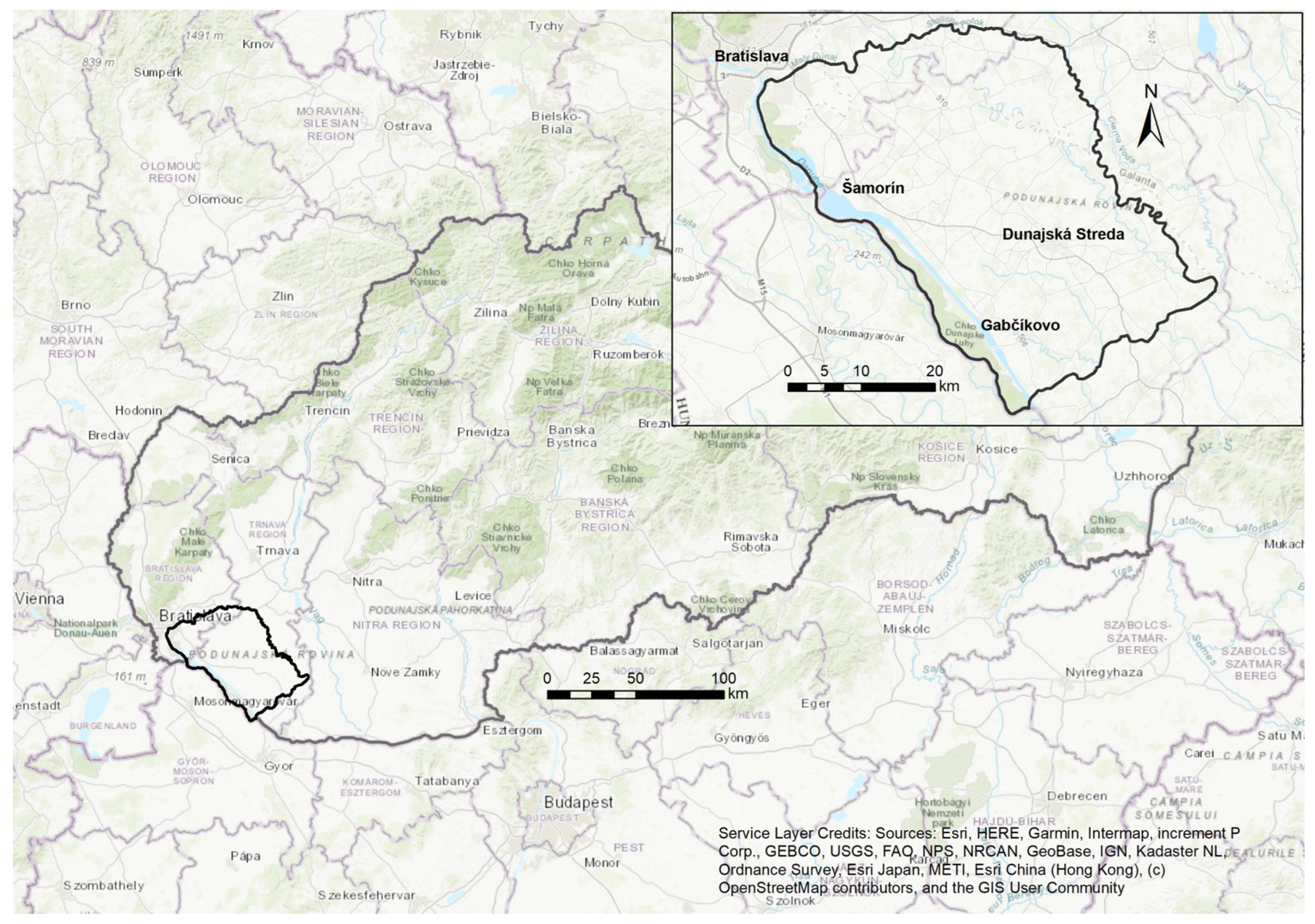
2.1. Study Area
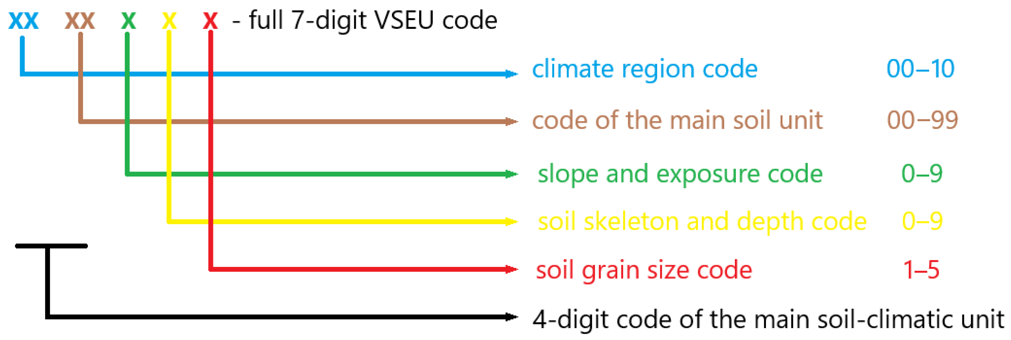
2.2. Methodology
- CWRC soils—Coefficient of soil water retention capacity;
- CQSU—Category quality of soil unit in SEU database;
- CSC—Category of soil skeleton content (skeleton content in %);
- CGS—Category of soil granularity (clay content in %);
- CSD—Category of the soil depth.
3. Results and Discussion
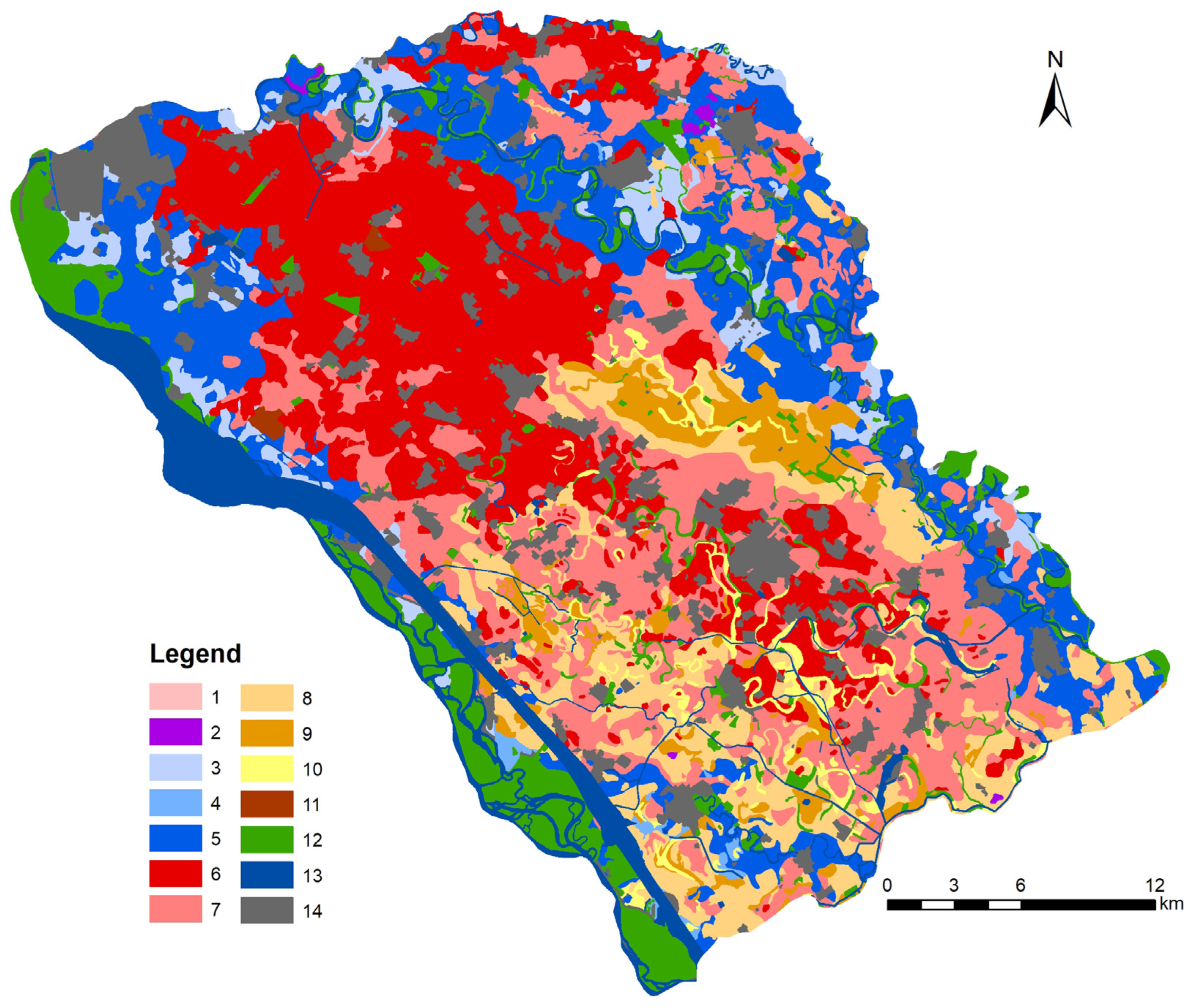
3.1. Spatial Distribution of Cumulative CWRC Soil Categories
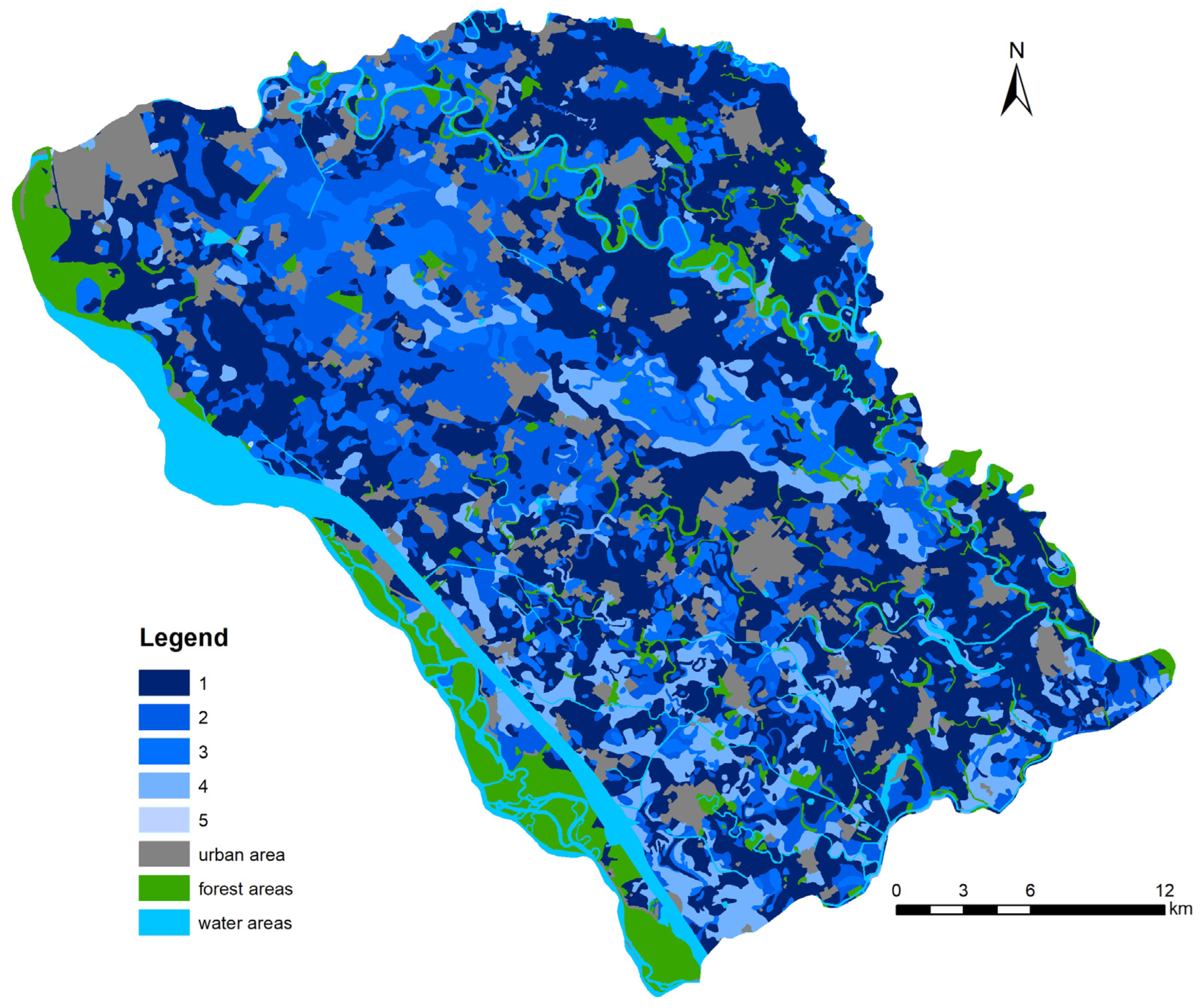
3.2. Systematic Monitoring of Soil Water Limits and Retention Capacity
3.3. Sustainable Landscape Management: Restoring Biodiversity and Stability Through Ecological Practices and Crop Rotation
3.4. Enhancing Soil Water Retention Capacity Through Crop Selection, Rotation, and Sustainable Fertilization Practices
3.5. Regenerative Agriculture and Agroforestry: Strategies for Enhancing Soil Health, Water Retention, and Landscape Sustainability
- Constructing wetlands and retention features
- Where feasible, wetlands or small retention ponds can be established to capture excess water and gradually release it into the surrounding soil.
- Limiting industrial fertilizers, pesticides, and other toxic substances from legacy environmental loads
- Excessive use of chemicals degrades the soil, reducing its ability to bind organic matter and retain water. Regenerative agriculture prioritizes organic alternatives.
- Holistic grazing
- Managed livestock rotation improves soil health, supports the natural nutrient cycle, and enhances the soil’s water retention capacity.
- Agroforestry systems
- Combining the cultivation of trees, shrubs, agricultural crops, or animal grazing offers solutions tailored to highly vulnerable areas such as protected water management zones.
- These systems are designed to promote soil conservation, water retention, biodiversity, and landscape sustainability.
- Windbreaks and shelterbelts protect soil from erosion and enhance water retention.
- Integrated hedgerows
- Hedgerows are dense plantings of native tree and shrub species along field edges or between plots.
- In Žitný ostrov, where soils are predominantly fertile and moist but sensitive to water management, it is important to carefully select species for agroforestry systems with mixed alley cropping.
- This system allows for the combination of crops and trees with the aim of improving soil sustainability, capturing carbon, and enhancing the economic value of farming.
- Integrated livestock management
- Grazing livestock (e.g., rotational grazing) ensures the input of organic matter through manure and leftover feed.
- Regular alternation of pastures with arable land improves the organic matter content in the soil.
4. Conclusions
Author Contributions
Funding
Institutional Review Board Statement
Data Availability Statement
Conflicts of Interest
References
- Rodrigues, A.F.; Latawiec, B.J.; Reid, B.J.; Solórzano, A.; Schuler, A.E.; Lacerda, C.; Fidalgo, E.C.C.; Scarano, F.R.; Tubenchlak, F.; Pena, I.; et al. Systematic review of soil ecosystem services in tropical regions. R. Soc. Open Sci. 2021, 8, 201584. [Google Scholar] [CrossRef]
- AbdelRahman, M.A.E.; Shalaby, A.; Aboelsoud, M.H.; Moghanm, F.S. GIS spatial model based for determining actual land degradation status in Kafr El-Sheikh Governorate, North Nile Delta. Model. Earth Syst. Environ. 2018, 4, 359–372. [Google Scholar] [CrossRef]
- Antal, J.; Špánik, F. Hydrology of Agricultural Landscapes; SPU: Nitra, Slovakia, 2004. (In Slovak) [Google Scholar]
- Schäfer, K.V.R.; Oren, R.; Lai, C.T.; Katul, G.G. Hydrologic balance in an intact temperate forest ecosystem under ambient and elevated atmospheric CO2 concentration. Glob. Change Biol. 2002, 8, 895–911. [Google Scholar] [CrossRef]
- Gahala, A.M.; Seal, R.R.; Piatak, N.M. Hydrologic Balance, Water Quality, Chemical-Mass Balance, and Geochemical Modeling of Hyperalkaline Ponds at Big Marsh, Chicago, Illinois, 2016–17; U.S. Geological Survey Scientific Investigations Report 2019–5078; U.S. Geological Survey: Reston, VA, USA, 2019; 31p. [CrossRef]
- Dominati, E.; Patterson, M.; Mackay, A. A Framework for Classifying and Quantifying the Natural Capital and Ecosystem Services of Soils. Ecol. Econ. 2010, 69, 1858–1868. [Google Scholar] [CrossRef]
- Gomiero, T.; Pimentel, D.; Paoletti, M.G. Environmental Impact of Different Agricultural Management Practices: Conventional vs. Organic Agriculture. Crit. Rev. Plant Sci. 2011, 30, 95–124. [Google Scholar] [CrossRef]
- Bommarco, R.; Klein, D.; Potts, S.G. Ecological intensification: Harnessing ecosystem services for food security. Trends Ecol. Evol. 2013, 28, 230–238. [Google Scholar] [CrossRef] [PubMed]
- Caswell, H. Theory and models in ecology: A different perspective. Ecol. Model. 1988, 43, 33–44. [Google Scholar] [CrossRef]
- Crawley, M.J. Statistical Computing: An Introduction to Data Analysis Using S-Plus; John Michael Wiley & Sons: Chichester, UK, 2002; p. 772. [Google Scholar]
- Guimaraes Couto, E.; Stein, A.; Klamt, E. Large area spatial variability of soil chemical properties in central Brazil. Agric. Ecosyst. Environ. 1997, 66, 139–152. [Google Scholar] [CrossRef]
- Hoosbeek, M.R.; Amundson, R.G.; Bryant, R.B. Pedological modelling. In Handbook of Soil Science; Sumner, M.E., Ed.; CRC Press: Boca Raton, FL, USA, 2000; pp. E77–E116. [Google Scholar]
- Tixier, P. Modelling in agroecology: From simple to complex models, and vice versa. In Proceedings of the International Crop Modelling Symposium (iCROPM 2020), Montpellier, France, 3–5 February 2020; CIRAD: Montpellier, France, 2020. [Google Scholar]
- Murkhart, A. Special Issue “Agroecosystem Modelling”. Plants 2021. [Google Scholar] [CrossRef] [PubMed]
- Mati, R. Influence of environmental conditions on the water regime of soils in the Eastern Slovak Lowlands. In Vplyv Antropogénnej Činnosti na Vodný Režim Nížinného Územia; Ústav Hydrológie Slovenskej Akadémie Vied: Michalovce, Slovakia, 2004; pp. 134–142. (In Slovak) [Google Scholar]
- Mati, B.M.; Mutie, S.; Gadain, H.; Home, P.; Mtalo, F. Impacts of Land-Use/Cover Changes on the Hydrology of the Transboundary Mara River, Kenya/Tanzania. Lakes Reservoirs. Res. Manag. 2008, 13, 169–177. [Google Scholar] [CrossRef]
- Takáč, J. Soil Water Saturation in Slovakia; NPPC: Washington, DC, USA, 2021; pp. 64–66. (In Slovak) [Google Scholar]
- Lal, R.; Shukla, M.K. Principles of Soil Physics; Marcel Dekker: New York, NY, USA, 2004. [Google Scholar] [CrossRef]
- Koch, H.J.; Stockifish, N. Loss of soil organic matter upon ploughing under a loess soil after several years of conservation tillage. Soil Tillage Res. 2006, 86, 73–83. [Google Scholar] [CrossRef]
- Gupta, S.C.; Larson, W.E. Estimating Soil Water Retention Characteristics from Particle Size Distribution, Organic Matter Percent, and Bulk Density. Water Resour. Res. 1979, 15, 1633–1635. [Google Scholar] [CrossRef]
- Papadopoulos, A. Soil Aggregates, Structure, and Stability. In Encyclopedia of Agrophysics; Gliński, J., Horabik, J., Lipiec, J., Eds.; Encyclopedia of Earth Sciences Series; Springer: Dordrecht, The Netherlands, 2011. [Google Scholar] [CrossRef]
- Amelung, W.; Bossio, D.; de Vries, W.; Kögel-Knabner, I.; Lehmann, J. Towards a global-scale soil climate mitigation strategy. Nat. Commun. 2020, 11, 5427. [Google Scholar] [CrossRef]
- Hüttl, R.; Prechtel, A.; Bens, O. (Eds.) Zum Stand der Humusversorgung der Böden in Deutschland. In Cottbuser Schriften zur Ökosystemgenese und Landschaftsentwicklung; Band 7; BTU: Cottbus, Germany, 2008. [Google Scholar]
- Demo, M.; Jureková, Z.; Húska, D.; Ďuďák, J.; Fehér, A.; Galambošová, J.; Halmová, D.; Hanáčková, E.; Kalúz, K.; Kotrla, M.; et al. Designing Sustainable Farming Systems in the Landscape; Slovenská Poľnohospodárska Univerzita: Nitra, Slovakia, 2011. (In Slovak) [Google Scholar]
- Vilček, J. Mapping and assessment of environmental functions of agricultural soils in Slovakia (in Slovak). Geogr. Časopis 2014, 66, 287–304. [Google Scholar]
- Mazúr, E.; Lukniš, M. Geomorphological subdivision of the SSR and CSSR. In Part of Slovakia; Slovenská kartografia: Bratislava, Slovakia, 1986. (In Slovak) [Google Scholar]
- Kočický, D.; Ivanič, B. Geomorphological Subdivision of Slovakia. M 1:50 000 [Online]; Štátny geologický ústav Dionýza Štúra: Bratislava, Slovakia, 2011; Available online: https://app.geology.sk/mapportal/indexn.html#/inspire/24 (accessed on 15 September 2024). (In Slovak)
- Lapin, M.; Faško, P.; Melo, M.; Šťastmý, P.; Tomlain, J. Climatic areas. M 1: 1 000 000 (in Slovak). In Atlas Krajiny Slovenskej Republiky. 1. vyd; Ministerstvo Životného Prostredia: Bratislava, Slovakia; Slovenská Agentúra Životného Prostredia: Banská Bystrica, Slovakia, 2002. [Google Scholar]
- Igaz, D.; Bárek, V.; Halaj, P.; Takáč, J.; Čimo, J. A comparison of measured soil moisture with simulated results obtained by selected models for Danubian lowland. Cereal Res. Commun. 2008, 36, 1619–1622. [Google Scholar]
- Tietje, O.; Tapkenhinrichs, M. Evaluation of Pedo-Transfer Functions. Soil Sci. Soc. Am. J. 1993, 57, 1088–1095. [Google Scholar] [CrossRef]
- Droogers, P.; Bouma, J. Simulation modelling for water governance in basins. Int. J. Water Resour. Dev. 2014, 30, 475–494. [Google Scholar] [CrossRef]
- Pachepsky, Y.A.; Timlin, D.; Varallyay, G. Artificial Neural Networks to Estimate Soil Water Retention from Easily Measurable Data. Soil Sci. Soc. Am. J. 1996, 60, 727–733. [Google Scholar] [CrossRef]
- Lamorski, K.; Pastusyka, J.; Krzyszczak, J.; Slawinski, C. Soil Water Dynamic Modelling Using 631 the Physical and Support Vector Machine Methods. Soil Sci. Soc. Am. 2013, 12, 632. [Google Scholar]
- Houšková, B. Retention Capacity of Agricultural Soils in Slovakia; Vedecké Práce VÚPOP: Bratislava, Slovakia, 2011; Volume 33, pp. 72–78. (In Slovak) [Google Scholar]
- Krnáčová, Z.; Hreško, J.; Vlachovičová, M. An evaluation of soil retention potential as an important factor of water balance in the landscape. Morav. Geogr. Rep. 2016, 24, 44–54. [Google Scholar] [CrossRef]
- Krnáčová, Z.; Kenderessy, P.; Hreško, J.; Kubínsky, D.; Dobrovodská, M. Assessment of Landscape Retention Water Capacity and Hydrological Balance in Traditional Agricultural Landscape (Model Area Liptovská Teplička Settlements, Slovakia). Water 2020, 12, 3591. [Google Scholar] [CrossRef]
- Šútor, J.; Štekauerová, V. Hydrophysical Characteristics of Žitný Ostrov Island Soils; UH SAV: Bratislava, Slovakia, 2000. (In Slovak) [Google Scholar]
- Mališ, J.; Homolák, M.; Orságová, K. Researh of soil moisture by integrated methods at mirobasin level. In Proceedings of Soil Science and Conservation Research Institute; The Soil Science and Conservation Research Institute NPPC: Banská Bystrica, Slovakia, 2009; ISBN 978-80-891128-59-4. [Google Scholar]
- Loke, M.H. Tutorial: 2-D and 3-D Electrical Imaging Surveys. 2001. Available online: https://www.geotomosoft.com (accessed on 15 September 2024).
- Džatko, M.; Sobotská, J.; Granec, M.; Bezák, P. Handbook for the Use of Maps Soil Ecology Units; Výskumný Ústav Pôdoznalectva a Ochrany Pôdy: Bratislava, Slovakia, 2009. (In Slovak) [Google Scholar]
- Bujnovský, R.; Balkovič, J.; Barančíková, G.; Makovníková, J.; Vilček, J. Assessment and Valuation of Ecological Functions of Agricultural Soils in Slovakia; Výskumný Ústav Pôdoznalectva a Ochrany Pôdy: Bratislava, Slovakia, 2009. (In Slovak) [Google Scholar]
- NAFC (National Agricultural and Food Center). Database of Soil-Ecological Units (QSEU) Slovakia; Mierka 1:10 000; NPPC: Lužianky, Slovakia, 2021. (In Slovak) [Google Scholar]
- Džatko, M. Assessment of the Production Potential of Agricultural Soils and Soil-Ecological Regions of Slovakia; Výskumný Ústav Pôdoznalecttva a Ochrany Pôdy: Bratislava, Slovakia, 2002. (In Slovak) [Google Scholar]
- Pišút, P.; Prochádzka, J. Contribution to the Knowledge of Soil Genesis and Land Cover Structure on Žitný Ostrov (Paleomeander Dunaja, Nekyje); Sobocká, J., Ed.; Diagnostika, Klasifikácia a Mapovanie Pôd: Bratislava, Slovakia, 2011. (In Slovak) [Google Scholar]
- Rehák, Š.; Stradiot, P.; Abaffy, D. Evaluation of Water Content in Soils of Žitný Ostrov from the Point of View of Its Exploitation for Biosphere. IOP Conf. Ser. Earth Environ. Sci. 2021, 906, 012095. [Google Scholar] [CrossRef]
- Jabro, J.D.; Evans, R.G.; Kim, Y.; Iversen, W.M. Estimating in situ soil–water retention and field water capacity in two contrasting soil textures. Irrig. Sci. 2009, 27, 223–229. [Google Scholar] [CrossRef]
- Walczak, R.; Ostrowski, J.; Witkowska-Walczak, B.; Slawinski, C. Spatial characteristic of hydro-physical properties in arable mineral soils in Poland as illustrated by field water capacity [FWC]. Int. Agrophys. 2002, 16, 151–159. [Google Scholar]
- Balkovič, J.; Orgánus, T.; Skalský, R. Potential water storage capacity of the root zone of cultural phytoceonoses in the Záhorská nížina—A quantification of soil accumulation function. Ekológia 2004, 23, 393–407. [Google Scholar]
- Šútor, J.; Rehák, Š. Quantification of water reserves in the soil aeration zone of Žitný ostrov. Geogr. Časopis 2007, 51, 61–75. [Google Scholar]
- Lacko-Bartošová, M.; Cagáň, Ľ.; Čuboň, J.; Kováč, K.; Kováčik, P.; Macák, M.; Moudrý, J.; Sabo, P. Sustainable and Organic Farming; Slovenská poľnohospodárska univerzita: Nitra, Slovakia, 2005. (In Slovak) [Google Scholar]
- Berndorfer, T. New Call for Proposals: Support for the Construction of Water Retention Measures in the Urban Landscape (in Municipalities); Slovenská Poľnohospodárska Univerzita: Bratislava, Slovakia, 2018. (In Slovak) [Google Scholar]


| The Range of CWRC Value Intervals Calculated from the Algorithm | Numerical Designation of Categories | CWRC Category |
|---|---|---|
| 1–11.2 | 1 | Very low |
| 11.3–22.4 | 2 | Very low |
| 22.5–33.6 | 3 | low |
| 33.7–44.8 | 4 | low |
| 44.9–56 | 5 | medium |
| 57–67.2 | 6 | medium |
| 67.3–78.4 | 7 | high |
| 78.5–89.6 | 8 | Very high |
| 89.7–100.8 | 9 | Very high |
| 100.9–112 | 10 | Very high |
| Soil Subtypes | VSEU | Numerical Designation of Categories | CWRC Category |
|---|---|---|---|
| Detailed breakdown of soil parameters | |||
| Eutric Fluvisol cultivated, medium deep, sandy-loamy, without skeleton | 0001001 | 5 | medium |
| Eutric Fluvisol cultivated, medium deep, sandy-loamy, weakly skeletal | 0001011 | 4 | medium |
| Eutric Fluvisol cultivated, medium deep, sandy-loamy, weakly skeletal | 0001021 | 4 | medium |
| Eutric Fluvisol cultivated, medium deep, sandy-loamy, moderately skeletal | 0001031 | 5 | medium |
| Eutric Fluvisol cultivated, shallow, loamy-sandy, moderately skeletal | 0001041 | 2 | very low |
| Eutric Fluvisol cultivated, shallow, loamy-sandy, without skeleton | 0014065 | 3 | low |
| Eutric Fluvisol cultivated, deep, loamy, without skeleton, | 0002002 | 9 | very high |
| Eutric Fluvisol cultivated, deep, loamy, moderately skeletal | 0002012 | 8 | very high |
| Eutric Fluvisol cultivated, deep, loamy, moderately skeletal | 0002042 | 8 | very high |
| Eutric Fluvisol cultivated, deep, loamy, without skeleton | 0012003 | 10 | very high |
| Eutric Fluvisol cultivated, deep, loamy-sandy, without skeleton | 0002005 | 9 | very high |
| Eutric Fluvisol cultivated, deep, loamy-sandy, without skeleton | 0015005 | 9 | very high |
| Chernozem cultivated, medium deep, sandy—loamy, weakly skeletal | 0036035 | 6 | medium |
| Chernozem cultivated, deep, loamy, without skeleton | 0018003 | 10 | very high |
| Chernozem cultivated, deep, clayey-loamy, without skeleton | 0034002 | 9 | very high |
| Chernozem cultivated, medium deep, clayey-loamy, moderately skeletal | 0018013 | 7 | high |
| Chernozem cultivated, medium deep, clayey-loamy, moderately skeletal | 0018033 | 6 | medium |
| Chernozem cultivated, medium deep, clayey-loamy, without skeleton | 0036012 | 8 | very high |
| Molic Fluvisol cultivated, deep, loamy-sandy, without skeleton | 0019001 | 8 | very high |
| Lithic Leptosol in complex with Haplic Leptosol, shallow, loamy, strongly skeletal | 0197062 | 1 | very low |
| Code | Category | Field Water Capacity of Water Column in Soil Profile (in mm) |
|---|---|---|
| 1 | Very high | 400> |
| 2 | High | 300–400 |
| 3 | Medium | 200–300 |
| 4 | Low | 100–200 |
| 5 | Very low | <100 |
Disclaimer/Publisher’s Note: The statements, opinions and data contained in all publications are solely those of the individual author(s) and contributor(s) and not of MDPI and/or the editor(s). MDPI and/or the editor(s) disclaim responsibility for any injury to people or property resulting from any ideas, methods, instructions or products referred to in the content. |
© 2025 by the authors. Licensee MDPI, Basel, Switzerland. This article is an open access article distributed under the terms and conditions of the Creative Commons Attribution (CC BY) license (https://creativecommons.org/licenses/by/4.0/).
Share and Cite
Krnáčová, Z.; Barančoková, M.; Labuda, M. Quantification of Soil Water Retention Capacity in the Protected Water Management Area Žitný Ostrov (Slovakia). Agriculture 2025, 15, 563. https://doi.org/10.3390/agriculture15050563
Krnáčová Z, Barančoková M, Labuda M. Quantification of Soil Water Retention Capacity in the Protected Water Management Area Žitný Ostrov (Slovakia). Agriculture. 2025; 15(5):563. https://doi.org/10.3390/agriculture15050563
Chicago/Turabian StyleKrnáčová, Zdena, Mária Barančoková, and Martin Labuda. 2025. "Quantification of Soil Water Retention Capacity in the Protected Water Management Area Žitný Ostrov (Slovakia)" Agriculture 15, no. 5: 563. https://doi.org/10.3390/agriculture15050563
APA StyleKrnáčová, Z., Barančoková, M., & Labuda, M. (2025). Quantification of Soil Water Retention Capacity in the Protected Water Management Area Žitný Ostrov (Slovakia). Agriculture, 15(5), 563. https://doi.org/10.3390/agriculture15050563