Abstract
Research on extreme environmental exploration using unmanned robots has recently attracted significant attention. In particular, unmanned robot exploration in vast areas such as Antarctica requires a system capable of remotely monitoring and controlling multiple robots. This paper proposes an integrated control system designed to monitor, control, and assign exploration tasks to multiple robots operating in extreme environments. This system utilizes GPS-based collaboration to support specific tasks, such as crevasse exploration and automatic battery charging, in Antarctic target areas. The system’s user interface (UI) is designed for efficiency and integrates elements such as remote control and mission execution commands tailored to the Antarctic environment. The proposed system was implemented using three robot platforms, and through performance evaluation tests in Antarctica, it achieved a cumulative driving distance of over 500 km and over 200 h of operation for over a month. The successful execution of simultaneous crevasse exploration by three robots highlights the system’s capability for coordinated multi-robot operations in extreme environments.
1. Introduction
With the rapid advancement of robotics and autonomous systems, increasing attention is being paid to the application of robotic technologies for exploration in extreme environments such as the deep sea, space, and polar regions. Among these, Antarctica presents one of the most challenging environments due to its extremely low temperatures, unpredictable terrain, and limited communication infrastructure. Autonomous robots capable of operating under such conditions must demonstrate robustness in mobility, energy efficiency, communication, and control systems. Robotic systems deployed in Antarctica are expected to navigate over snowfields and crevasses, function reliably in sub-zero temperatures (often below −50 °C), and operate independently over extended periods without human intervention. In addition, communication over long distances and coordination of multiple units present significant challenges in such remote areas. To overcome these difficulties, integrated multi-robot control systems that support autonomous navigation, environmental sensing, and mission execution have become a key focus in recent polar robotics research. In this study, we propose a wide-area multi-robot control system designed for long-range missions around Jang Bogo Station in Antarctica. The system enables GPS-based collaborative exploration, crevasse detection using ground-penetrating radar (GPR), and autonomous battery recharging operations. Field experiments conducted in Antarctica validated the system’s ability to support multi-robot deployment and long-term mission execution within a 50 km radius.
The remainder of this paper is organized as follows: Section 2 reviews the related research on Antarctic robotics, communication strategies, and multi-robot control. Section 3 describes the architecture of the proposed system, including communication and data transmission protocols. Moreover, the section introduces the user interface and control functions. Section 4 presents the experimental results from field deployment in Antarctica. Section 5 concludes the paper and outlines directions for future work.
2. Related Works
2.1. Robotic Exploration in Polar Regions
Robotic platforms have been widely applied in Antarctic missions due to the region’s dangerous and inaccessible terrain. One of the earliest efforts was the NOMAD robot developed at Carnegie Mellon University, which utilized stereo vision, pose sensing, and laser rangefinding for meteorite detection [1,2,3]. The CHINARE program introduced a LiDAR-equipped all-terrain vehicle designed for long-range surveys across the polar landscape [4]. Similarly, the Yeti robot, developed by CRREL, used ground-penetrating radar (GPR) to autonomously detect crevasses during glacial missions [5]. In Korea, the Korea Polar Research Institute developed GENTU, a robot platform specialized for crevasse detection near Jang Bogo Station. GENTU has undergone several upgrades, including a sail-based wind-assist mechanism and power-saving modules [6,7,8]. While these platforms demonstrated autonomous capabilities, they typically lacked integrated architectures to support multi-robot coordination and long-distance communication, which are essential for scalable polar exploration.
2.2. Robot Performance and Environmental Challenges
Robots operating in Antarctica must maintain performance under extreme environmental constraints, such as temperatures falling below −50 °C, strong winds, and unpredictable snow terrains. Studies such as [9,10] emphasize the importance of system level cold resistance, energy management, and robust navigation in field-deployed Antarctic robots. Some robotic systems have undergone long-term tests in the inland Antarctic plateau, showing partial success in extended-duration missions. Moreover, energy-efficient designs, including wind-electric hybrid power systems and snowboarding-based locomotion, have been recently explored to enhance endurance [7,8]. However, such platforms typically remain single-unit systems with limited cooperative functions.
2.3. Long-Range Communication and Networking in Antarctica
Reliable long-distance communication is another critical bottleneck in polar robotics. While Wi-Fi, LTE, and LoRa are used in terrestrial outdoor robotics, their performance severely degrades in Antarctica due to physical obstructions, lack of infrastructure, and dynamic weather [11,12]. Recent research has investigated the use of delay-tolerant networks (DTNs) and satellite communication, including Starlink-based solutions, to overcome these limitations [13,14]. In particular, Michel et al. evaluated the real-world performance of Starlink in remote areas, demonstrating its viability as a high-bandwidth low-latency option. Techniques such as port-forwarding and Starlink bypass mode have been investigated as viable solutions for maintaining low-bandwidth but stable control channels in emergency or disconnected scenarios [14]. Security concerns in remote control and data transmission also arise in distributed IoET (Internet of Exploration Things) environments. For this, blockchain-inspired approaches such as Proof-of-Stake (PoS) have been proposed to enhance communication reliability and data integrity [15].
2.4. Multi-Robot Control, Scheduling, and Task Allocation
Coordinating multiple robots in extreme environments requires robust task allocation, scheduling, and communication frameworks. Recent studies in multi-robot cooperative exploration include both general and Antarctic-specific methods:
- A general review of multi-robot cooperative exploration outlines architecture modules like localization, map merging, task allocation, and communication under constraints of limited bandwidth and harsh conditions [16].
- In Antarctic environments, Kang and Lee proposed a probabilistic task scheduling algorithm that considers crevasse position uncertainties. Their method using nearest-neighbor probabilistic modeling outperformed ACO and GA in cost and computation time [13].
- In addition, broader reviews have examined task scheduling strategies across mobile robot systems in various environments beyond the Antarctic context. A systematic review in Robotics summarizes key trends, identifies underexplored areas, and highlights the need for integrated scheduling and allocation strategies [17].
By integrating these more recent and context-relevant studies, this work situates itself within both established multi-robot frameworks and the unique constraints of Antarctic operations. Unlike prior approaches, our system demonstrates real-world field validation in Antarctica with integrated communication, scheduling, and monitoring capabilities.
3. Multi-Robot Integrated Control System
3.1. Wireless Communication-Based Control for Extreme Environment Robots
The control architecture for extreme environment robots based on wireless communication is illustrated in Figure 1. Two wireless communication methods are employed to ensure robust and long-range control in polar environments: a secure long-range Wi-Fi module, developed specifically for extreme environment missions and capable of transmitting over distances exceeding 50 km [15], and a satellite communication module used as a backup for emergency situations [14]. Robot command hierarchy prioritizes control signals as follows: direct commands from the on-site controller take precedence, followed by commands issued from the remote control center. If no external commands are received, the robot autonomously executes its preloaded driving path and mission sequence.
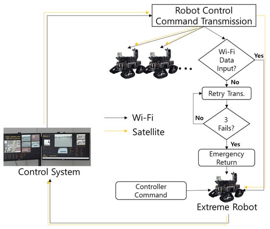
Figure 1.
Robot control command and data transmission flow chart using Wi-Fi and satellite.
The control system continuously monitors the robot’s status and video feed via secure, internal network-based Wi-Fi communication. If the connection is lost, the robot attempts to re-establish the connection up to three times. If all reconnection attempts fail, the system switches to automatic return-to-base (RTB) mode. In the event of a communication outage, the satellite communication module is used for emergency data transmission and minimal status monitoring. This configuration utilizes Starlink’s bypass mode to implement a port-forwarding mechanism, enabling low-bandwidth, long-distance robot data transmission even in hazardous situations.
3.2. Multi-Robot Control System Interface
To enable coordinated operation of multiple robots in the Antarctic environment, a centralized control system with an integrated command structure is essential. The main interface of the proposed control system is shown in Figure 2. The core component of the interface is the map viewer (highlighted with a red box), which displays the current positions and driving paths of all active robots. Within the map viewer, users can interactively assign mission areas or specific waypoints for coverage scheduling by left-clicking on the map. A right-click resets any previously assigned points or zones. In the lower left panel, users can monitor key status data from multiple robots in real time, including current operational status, control mode, battery voltage, GPS coordinates, heading direction, linear velocity, and angular velocity. The lower right panel contains controls for adjusting the map viewer (zooming and panning), selecting specific robots, assigning coverage areas, and accessing the full command menu for robot operations. Additionally, the interface includes a dedicated camera viewer, which allows operators to select and view real-time image feeds from multiple cameras mounted on each robot. This feature enhances situational awareness and supports monitoring in complex or dangerous terrain conditions
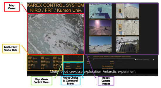
Figure 2.
The main screen of a multi-robot control system.
3.3. Individual Robot Control Interface and Remote Operation
As shown in Figure 3, the system allows users to open an individual robot control window via the robot selection menu on the main interface. This control window provides a comprehensive view of the robot’s sensor data and remote operation options. Within the window, users can monitor 2D scan data derived from 3D LiDAR sensors, front-facing camera feeds, and panoramic (surround-view) images. These sensory inputs help operators assess environmental conditions in real time. Below the sensory displays, the remote control menu enables users to issue commands directly to the robot. The interface also includes a status message panel, which displays important mission updates such as task initiation, completion, and alerts. In addition, users can toggle between different operational modes—status monitoring, autonomous driving, or manual remote control—depending on mission needs. In the upper right corner, a minimap shows the robot’s current position within the operational area. At the bottom of the interface, detailed robot control functions are available, including:
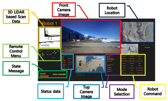
Figure 3.
The control window for each robot.
- Docking and undocking for automated charging at observation stations.
- GPS power reset.
- Activation/deactivation of the GPR (Ground Penetrating Radar) sensor for crevasse detection.
- Return-to-base (RTB) command for safe retrieval.
Figure 4 shows an example of remote control testing conducted in Antarctica. During remote operation, the robot can be controlled using either a joystick or keyboard input, depending on user preference and task requirements.
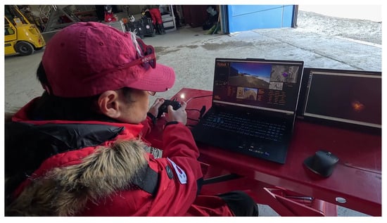
Figure 4.
Remote control testing in Antarctica.
3.4. GPS-Based Monitoring and Positioning Interface
GPS coordinates are required to inform the robot of any exploration area or mission point in a wide area such as Antarctica. Furthermore, Google Earth was utilized to visualize the robot’s trajectory and current location, allowing the controller to intuitively monitor the robot’s path and location in real time. This is achieved by converting NavSatFix (GPS) messages received from the robot’s operating system into a KML (Keyhole Markup Language) file in real time, saving it, and then loading it. Furthermore, the path required for the robot’s exploration and mission execution can be converted into a waypoint list in local UTM offset format from the KML file created by the controller, as shown in Figure 5.
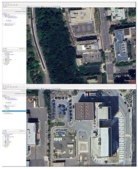
Figure 5.
Google Earth-based monitoring and positioning-based interface. Reprinted/adapted with permission from Ref. [18]. 2015, [396402900917].
4. Multi-Robot Integrated Control System Test Results
4.1. Domestic Testing
To validate the functionality of the proposed multi-robot integrated control system, preliminary tests were conducted at the Pohang Safe Robotics Verification Center in South Korea. Two mission scenarios were designed to simulate Antarctic operations. The first mission involved automated docking for charging at a weather observation station, replicating the real-world use case of charging equipment deployed in the Antarctic field. In this mission, the robot autonomously navigated to a predefined location, reported its arrival to the user, and then successfully executed the docking procedure upon receiving a docking command. The second mission focused on autonomous navigation for crevasse detection in randomly selected areas. This scenario was designed to simulate terrain exploration in unknown environments. As shown in Figure 6, the main interface and control panel of the system clearly demonstrate that the robot successfully identified a designated visual marker and completed the docking procedure. These results confirm that the control system is capable of supporting reliable autonomous operation and precise docking behavior under test conditions similar to those encountered in polar environments.
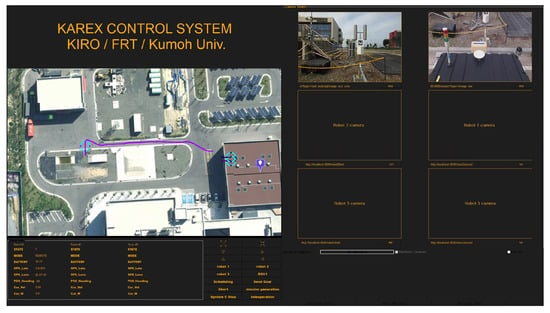
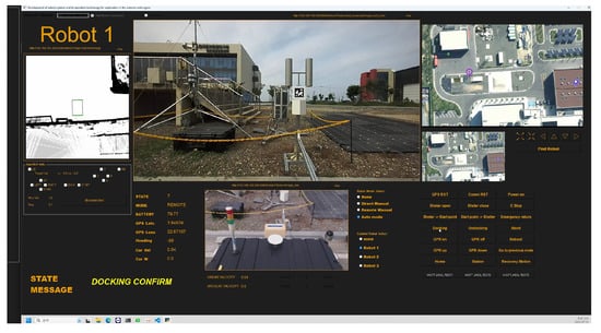
Figure 6.
Results of docking mission for observatory charging.
In the second mission, users designated an exploration area for the robot by either clicking on the main interface’s map viewer or by directly inputting a set of GPS coordinates. As shown in Figure 7 (upper), the defined region was transmitted to the path planner [13,19], which generated an appropriate trajectory considering the robot’s sensor coverage. The planned route was then sent back to the control system, as illustrated in Figure 7 (middle). Finally, the user issued a mission execution command to the robot, prompting it to begin exploration along the assigned path. Upon completion of the mission, the robot reported its status to the user. If a return command was issued, the robot autonomously navigated back to its original starting location (Figure 7 (lower)).
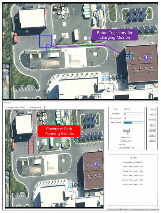
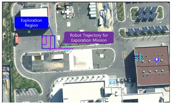
Figure 7.
Results of the exploration mission: (upper) allocate exploration area; (middle) create a scheduler path; (lower) complete the exploration mission and return.
4.2. Antarctic Multi-Robot Field Testing
To evaluate the system under real-world polar conditions, multi-robot field tests were conducted in Antarctica. The robots were transported to the Jang Bogo Antarctic Research Station via the research icebreaker ARAON, and after several months of transit, preliminary maintenance and basic operational checks were conducted on-site prior to testing. The field test focused on two primary objectives:
- Validating long-distance autonomous round-trip navigation to a remote observation outpost.
- Evaluating coverage-based exploration using multi-robot coordination.
For the first objective, a long-range mission was executed where a single robot autonomously traveled from the Jang Bogo Station to a designated observation point located near the Browning Pass region—covering a round-trip distance of approximately 54 km. As illustrated in Figure 8, the robot successfully navigated over a variety of terrain, including rocky surfaces and iceberg-laden paths, and returned to base without manual intervention. Over the course of one month, the robot accumulated more than 200 h of operational time and over 500 km of total driving distance, as verified by logged GPS trajectory data.
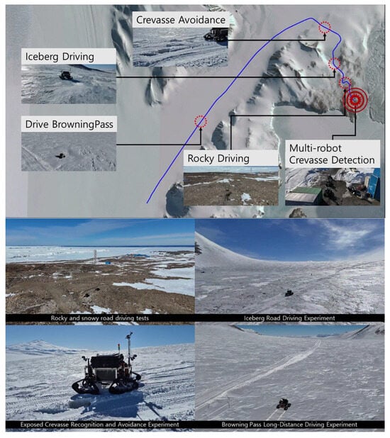
Figure 8.
Long-distance autonomous driving route and section driving experiment.
For the second objective, three robots were deployed simultaneously to conduct area coverage missions. As shown in Figure 9, each robot was assigned an individual exploration area. The mission path was generated using a coverage scheduling algorithm. The robot’s current location, the number of operating robots, the GPR sensing area, and the speed of each robot were input, and the path was distributed to a set of GPS waypoints. Each robot followed the assigned path sequentially and autonomously returned to the base upon mission completion. This test verified the system’s ability to efficiently explore and expand the range by coordinating multiple robots even under extreme conditions.
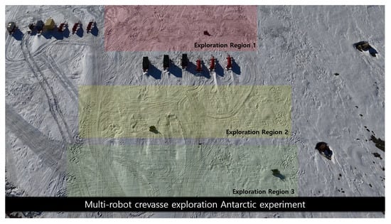
Figure 9.
Allocate exploration area.
Following the proposed system deployment, each robot autonomously navigated to the first waypoint of its assigned exploration route, as shown in Figure 10. The exploration paths were generated with consideration for the sensing range and resolution of the onboard Ground Penetrating Radar (GPR) sensor, which is essential for crevasse detection. The robots successfully followed the designated waypoints and completed their individual missions (Figure 11). Real-time monitoring of the robots’ trajectories was conducted using Google Earth, which provided a visual overlay of GPS-based paths and current positions. Although the arrival times varied depending on the distance from the base to each assigned area, all robots reached their respective zones, conducted exploration tasks, and returned autonomously without failure. As shown in Figure 12, the accumulated GPS data illustrate the full mission trajectories across all robots during the test period. These results confirm that the proposed multi-robot control and monitoring system is effective for Antarctic exploration missions. The system successfully supported over 500 km of total exploration distance and achieved a 100% autonomous return rate, validating both its reliability and operational robustness in extreme environments, as shown in Table 1. Currently, the deployed control system is in active use at Jang Bogo Station, integrated into the station’s internal network infrastructure for real-time operations and long-term monitoring, as depicted in Figure 13.
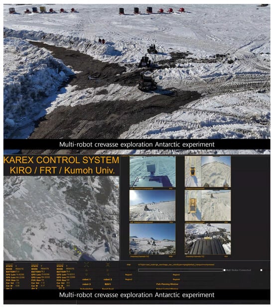
Figure 10.
Autonomous driving to the exploration point.
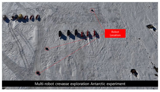
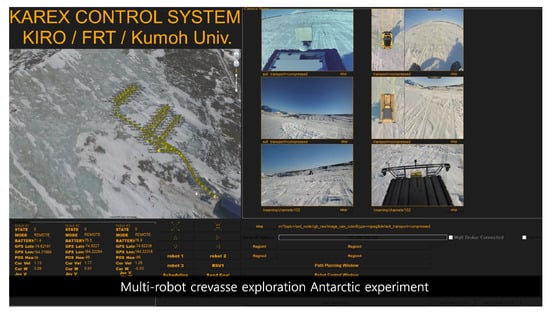
Figure 11.
Multi-robot exploration driving drone view and control system main screen.
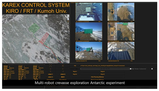
Figure 12.
Results of multi-robot exploration route.

Table 1.
Performance test results of the control system in Antarctica.
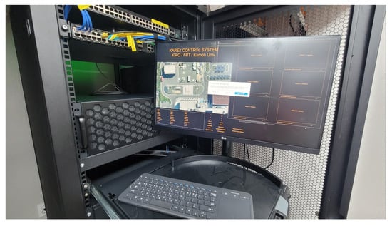
Figure 13.
Deployed control system at Jang Bogo Station.
5. Discussion
The results from both domestic and Antarctic field tests demonstrate that the proposed multi-robot integrated control system can effectively support long-duration autonomous missions in extreme environments. Compared to earlier systems such as NOMAD [1,2,3], Yeti [5], and GENTU [6], which focused primarily on individual mission components such as sensing or navigation, our system integrates multiple mission-critical functions including long-distance communication, cooperative task scheduling, remote monitoring, and autonomous docking within a unified platform. The real-world implementation of coverage-based exploration with autonomous return over 500 km of accumulated distance shows a significant advancement over earlier field-tested systems, many of which remained limited to semi-autonomous operation or short-range missions.
While systems like Yeti demonstrate reliable crevasse detection using GPR, they lack multi-robot coordination capabilities and remote control over wide areas. GENTU addresses energy efficiency but is limited in control interface flexibility and long-range autonomy. Our system extends these capabilities by supporting simultaneous multi-robot operation, GPS-defined area planning, and reliable execution under ultra-low temperatures, providing a scalable foundation for future polar deployments.
Nonetheless, several limitations must be acknowledged. First, although the system achieved a 100% return rate during field trials, the mission environments were still semi-controlled. True inland Antarctic environments, such as deep glacier zones present more severe risks including whiteout conditions, crevasse clustering, and extreme power constraints that were not fully simulated in this work. Second, communication failover mechanisms such as Starlink port-forwarding showed latency tolerance but require further optimization under variable bandwidth.
From a broader perspective, the system directly addresses key challenges outlined in the Introduction, particularly the need for scalable robotic systems capable of long-range autonomous operation, fault-tolerant control, and mission-level scheduling in harsh environments. The success of long-distance autonomous driving and GPS-driven exploration path execution suggests that robotic systems could replace human operators in highly dangerous zones, significantly reducing exposure to crevasse-related risks.
In terms of scientific utility, the system can be adapted to support various sensing payloads beyond GPR, such as seismic, meteorological, or biological sensors, enabling year-round unmanned data collection. Operationally, deploying such systems every 100 km would create a distributed robotic network capable of relaying sensor data, managing mobile observatories, and facilitating inland traverse planning toward the South Pole or between research stations.
6. Conclusions
In this study, we proposed and validated a multi-robot integrated control system designed for autonomous exploration in extreme environments such as Antarctica. This system was developed to address key challenges of polar operations, including long-distance communication, remote monitoring, and mission management for multiple robots. The control interface supports real-time monitoring, path planning, and camera streaming, while also providing robust command and control capabilities even in ultra-low temperature environments. Through domestic testing at the Pohang Safety Robot Verification Center and extensive field trials at the Jang Bogo Antarctic Research Station, the system successfully supported two major mission types: autonomous docking for recharging and multi-robot coverage-based exploration. The system enabled a robot to complete a 54 km round-trip mission, achieving over 500 km cumulative travel and 200 h of continuous operation. Users were able to assign GPS-defined exploration tasks through a mission planner, and the robots successfully conducted GPR-based crevasse detection. These results demonstrate the practicality and reliability of the system for long-term, large-scale autonomous operations in polar regions. Currently deployed at Jang Bogo Station, the system plays a key role in unmanned route scouting and observatory management. Integration with broader inter-station communication networks is expected to support inland exploration within a 100 km radius. Over time, the deployment of such robotic systems in a networked configuration could enable persistent environmental monitoring and fundamentally change how scientific operations are conducted in Antarctica.
Future research directions include extending scheduling algorithms to adapt to dynamic environmental inputs such as real-time weather or terrain data, integrating aerial robots (e.g., unmanned aerial vehicles) for terrain preview or communication relay, and autonomous battery management of hydrogen- or solar-powered support systems for inland winter operations, with the aim of establishing interoperable communications between multiple stations for a seamless robot network with a 100 km radius.
Author Contributions
Conceptualization, T.U.; methodology, T.U. and J.K. (Jiwook Kwon); J.L. and H.L.; software and simulation, T.U., J.K. (Jiwook Kwon) and J.L.; validation, J.K. (Jiwook Kwon) and T.U.; investigation, Y.-H.C.; Data curation, J.K. (Jongchan Kim), J.L. and H.L.; writing—original draft, T.U.; writing—review and editing, T.U.; supervision T.U. and Y.-H.C. All authors have read and agreed to the published version of the manuscript.
Funding
This research was supported by Korea Institute of Marine Science & Technology Promotion (KIMST) funded by the Ministry of Trade, Industry and Energy in 2025 (Project Number 20210630).
Institutional Review Board Statement
Not applicable.
Informed Consent Statement
Not applicable.
Data Availability Statement
The original contributions presented in the study are included in the article, further inquiries can be directed to the corresponding author.
Conflicts of Interest
The authors declare no conflicts of interest.
References
- Apostolopoulos, D.S.; Pedersen, L.; Shamah, B.N.; Shillcutt, K.; Wagner, M.D.; Whittaker, W.L. Robotic Antarctic meteorite search: Outcomes. In Proceedings of the 2001 IEEE International Conference on Robotics and Automation (ICRA), Seoul, Republic of Korea, 21–26 May 2001; Volume 4, pp. 4174–4179. [Google Scholar] [CrossRef]
- Apostolopoulos, D.S.; Wagner, M.D.; Shamah, B.N.; Pedersen, L.; Shillcutt, K.; Whittaker, W.L. Technology and field demonstration of robotic search for Antarctic meteorites. Int. J. Robot. Res. 2000, 19, 1015–1032. [Google Scholar] [CrossRef]
- Wagner, M.D.; Apostolopoulos, D.; Shillcutt, K.; Shamah, B.; Simmons, R.; Whittaker, W.R. The science autonomy system of the Nomad robot. In Proceedings of the 2001 IEEE International Conference on Robotics and Automation (ICRA), Seoul, Republic of Korea, 21–26 May 2001; pp. 1742–1749. [Google Scholar] [CrossRef]
- He, Y.; Chen, C.; Bu, C.; Han, J. A polar rover for large-scale scientific surveys: Design, implementation and field test results. Int. J. Adv. Robot. Syst. 2015, 12, 10. [Google Scholar] [CrossRef]
- Lever, J.H.; Delaney, A.J.; Ray, L.E.; Trautmann, E.; Barna, L.A.; Burzynski, A.M. Autonomous GPR surveys using the polar rover Yeti. J. Field Robot. 2012, 30, 194–215. [Google Scholar] [CrossRef]
- Chung, C.; Kim, H.; Yoon, D.; Lee, J. Development of an unmanned ground robot platform for polar regions: GENTU. Korea Robot. Soc. Rev. 2023, 20, 19–27. [Google Scholar]
- Guo, L.; Liu, G.; Luo, Y.; Jiang, P.; Zhao, J. A wind-electric hybrid polar roaming robot: Design, modeling, and experiments. J. Field Robot. 2024, 41, 131–143. [Google Scholar] [CrossRef]
- Luo, Y.; Liu, G.; Guo, L.; Zhu, Y.; Zhao, J. Scalable wing sailing and snowboarding enhance efficient and energy-saving mobility of polar robot. IEEE/ASME Trans. Mechatron. 2024, 29, 3833–3844. [Google Scholar] [CrossRef]
- Turner, J.; Marshall, G.J.; Clem, K.; Colwell, S.; Phillips, T.; Lu, H. Antarctic temperature variability and change from station data. Int. J. Climatol. 2020, 40, 2986–3007. [Google Scholar] [CrossRef]
- Uhm, T.; Kwon, J.; Noh, K.; Kim, J.; Lee, H.; Choi, Y. Development of robotic system for exploration in extreme cold regions (tested in Antarctica). Electronics 2025, 14, 1983. [Google Scholar] [CrossRef]
- Mallorqui, A.; Zaballos, A.; Serra, D. A delay-tolerant network for Antarctica. IEEE Commun. Mag. 2022, 60, 56–62. [Google Scholar] [CrossRef]
- Uhm, T.; Jung, J.; Cho, S.; Bae, G.; Choi, Y. Multiple wireless networks based control system for unmanned surveillance robot. J. Korea Robot. Soc. 2020, 15, 392–397. [Google Scholar] [CrossRef]
- Kang, S.; Lee, H. Probabilistic Multi-Robot Task Scheduling for the Antarctic Environments with Crevasses. Symmetry 2024, 16, 1229. [Google Scholar] [CrossRef]
- Michel, F.; Trevisan, M.; Giordano, D.; Bonaventure, O. A first look at Starlink performance. In Proceedings of the 22nd ACM Internet Measurement Conference (IMC 2022), Nice, France, 25–27 October 2022; pp. 130–136. [Google Scholar] [CrossRef]
- Lee, W.; Kim, K. Security analysis for applying the proof-of-stake consensus algorithm to IoET network in Antarctica. In Proceedings of the 2023 International Conference on Information and Communication Technology Convergence (ICTC), Jeju Island, Republic of Korea, 11–13 October 2023; pp. 403–405. [Google Scholar] [CrossRef]
- Yasaei, A.; Saeedzadeh, H.; Ardakani, H.D.; Manzuri, M.T. Multi-robot systems for cooperative exploration in unknown environments: A survey. Robotics 2024, 13, 26. [Google Scholar] [CrossRef]
- Golchin, A.; Monfared, P.; Pedram, M.M. Task scheduling with mobile robots—A systematic literature review. Robotics 2023, 14, 75. [Google Scholar] [CrossRef]
- Google Earth Pro. Google LLC, Mountain View, CA, USA. Available online: https://earth.google.com/ (accessed on 7 September 2025).
- Kim, S.; Lee, H. Multi-robot task scheduling with ant colony optimization in Antarctic environments. Sensors 2023, 23, 751. [Google Scholar] [CrossRef] [PubMed]
Disclaimer/Publisher’s Note: The statements, opinions and data contained in all publications are solely those of the individual author(s) and contributor(s) and not of MDPI and/or the editor(s). MDPI and/or the editor(s) disclaim responsibility for any injury to people or property resulting from any ideas, methods, instructions or products referred to in the content. |
© 2025 by the authors. Licensee MDPI, Basel, Switzerland. This article is an open access article distributed under the terms and conditions of the Creative Commons Attribution (CC BY) license (https://creativecommons.org/licenses/by/4.0/).