Article

Administrative Fragmentation and Functional Integration: Quantifying Urban Interstice Dynamics in Jurong Using Mobile Origin–Destination (OD) Flows

by
Pengfei Fang
1,
Ziqing Wang
1,
Yuhao Huang
2,*,
Yile Chen
3,* and
Xiaojin Cao
4
1
School of Architecture and Urban Planning, Nanjing University, Nanjing 210093, China
2
Faculty of Innovation and Design, City University of Macau, Avenida Padre Tomás Pereira, Taipa, Macau 999078, China
3
Faculty of Humanities and Arts, Macau University of Science and Technology, Avenida Wai Long, Taipa, Macau 999078, China
4
College of Architecture and Urban Planning, Tongji University, Shanghai 200092, China
*
Authors to whom correspondence should be addressed.
Appl. Sci. 2025, 15(10), 5675; https://doi.org/10.3390/app15105675
Submission received: 10 March 2025 / Revised: 13 May 2025 / Accepted: 17 May 2025 / Published: 19 May 2025
(This article belongs to the Special Issue Sustainable Urban Green Infrastructure and Its Effects)

Abstract

:
Urban interstices are transitional spaces that emerge between expanding metropolitan regions. Despite increasing scholarly interest, the empirical analysis of these cities’ spatial development and functional integration remains scarce, particularly within the contexts of state-led urbanization, where administrative boundaries significantly shape development outcomes. This study quantitatively investigates urban interstice dynamics through a detailed analysis of Jurong City, which is located between the cities of Nanjing and Zhenjiang in the Chinese Yangtze River Delta. Utilizing mobile phone signaling data and origin–destination (OD) flow analysis, this research study systematically measures the intensity, directionality, and spatial patterns of human mobility flows between Jurong and its neighboring cities. The findings demonstrate that Jurong has a strong functional connection to Nanjing, with nearly 60% of its outbound mobility directed toward the city, despite being governed by Zhenjiang. This misalignment reveals a structural tension between functional integration and administrative hierarchy, fostering distinct subcenters such as Baohua (residential) and Guozhuang (innovation). Overall, the findings highlight the need to move beyond territorially bounded governance toward functionally coordinated regional strategies. Urban interstices can serve as effective connectors across fragmented systems, supporting more balanced and adaptive metropolitan integration. Leveraging real-time mobility data enables planners to identify spatial–functional linkages that transcend administrative boundaries, informing more responsive governance without requiring formal realignment.

1. Introduction

1.1. Research Background

Urbanization processes across the globe have increasingly highlighted the importance of urban interstices, which are defined as transitional urban areas situated between major metropolitan centers [1,2,3,4,5,6]. These spaces, characterized by their unique spatial and administrative circumstances, absorb economic and population spillovers from adjacent core cities, yet they simultaneously maintain distinct local identities and governance structures [7]. We conceptualize urban interstices as full administrative urban units embedded within interstitial zones between metropolitan cores, distinct from traditional urban interstices. Despite growing academic attention being paid to interstitial spaces, systematic quantitative research addressing their spatial dynamics remains limited. In their foundational call for greater scholarly attention to interstitial urban areas, Phelps and Silva (2018) emphasize the need to systematically “mind the gaps”, pointing out that such transitional zones warrant deeper empirical exploration to understand their spatial evolution, governance challenges, and functional roles within broader urban systems [3,8].
Existing research on urban interstices has primarily employed qualitative methodologies or focused on case studies in Western metropolitan contexts. In these settings, interstitial spaces often emerge from market-driven suburban expansion, producing low-density, fragmented landscapes marked by regulatory discontinuities and infrastructural mismatch. Such areas frequently manifest as brownfields, fringe belts, or underutilized buffer zones—embedded in wider patterns of zoning, speculative development, and socio-spatial inequality [9,10,11,12,13,14,15,16,17,18,19]. However, the experience of urban interstices in rapidly urbanizing countries, notably China, differs considerably due to distinct administrative structures and state-led regional planning frameworks [7,9]. In China, administrative boundaries significantly impact urbanization trajectories, creating distinct dynamics compared to market-oriented urban growth common in Western contexts [20]. Chinese urban interstices are typically shaped by a combination of state intervention, administrative jurisdictions, and economic spillovers from adjacent metropolitan cores. Despite this, few studies have quantitatively explored how such administrative fragmentation interacts with functional urban integration, resulting in distinctive spatial development patterns.

1.2. Problem Statement and Objectives

Jurong City, located strategically between Nanjing (a major metropolitan city) and Zhenjiang (its administrative jurisdiction city) in the rapidly urbanizing Yangtze River Delta region of China, provides an exemplary case study for examining these dynamics. Jurong represents a typical urban interstices scenario: it is functionally integrated into the metropolitan economy of Nanjing through substantial commuting flows and economic interactions, yet administratively dependent upon Zhenjiang. This administrative fragmentation creates mismatches in spatial planning and infrastructure investment, potentially limiting development prospects and integration efficiency in Jurong.
This study addresses the critical need for quantitative research into urban interstice dynamics by employing a data-driven approach utilizing mobile signaling data and origin–destination (OD) flow analyses. Specifically, this research aims to carry out the following: (1) quantitatively assess the spatial and functional integration of Jurong City with neighboring cities (Nanjing and Zhenjiang); (2) analyze the influence of administrative boundaries in shaping the spatial structure and intercity connectivity of urban interstices; (3) explore how Jurong balances regional integration pressures with the imperative to maintain local economic and spatial autonomy; and (4) advance international understanding of how interstitial urban areas mediate between fragmented governance and functional integration, offering transferable insights into spatial coordination and adaptive metropolitan governance across diverse global contexts.
Through a detailed empirical analysis based on mobile signaling data, this research provides a replicable methodological framework for quantifying the spatial and functional dynamics of urban interstices. It bridges existing theoretical discussions with empirical findings, offering significant insights into the mechanisms by which administrative boundaries and market forces jointly shape urban interstitial development. The principal conclusions drawn from this study underscore the necessity of coordinated governance mechanisms, targeted infrastructure development, and policy alignment to effectively integrate urban interstices into metropolitan networks without compromising their distinct spatial identities.

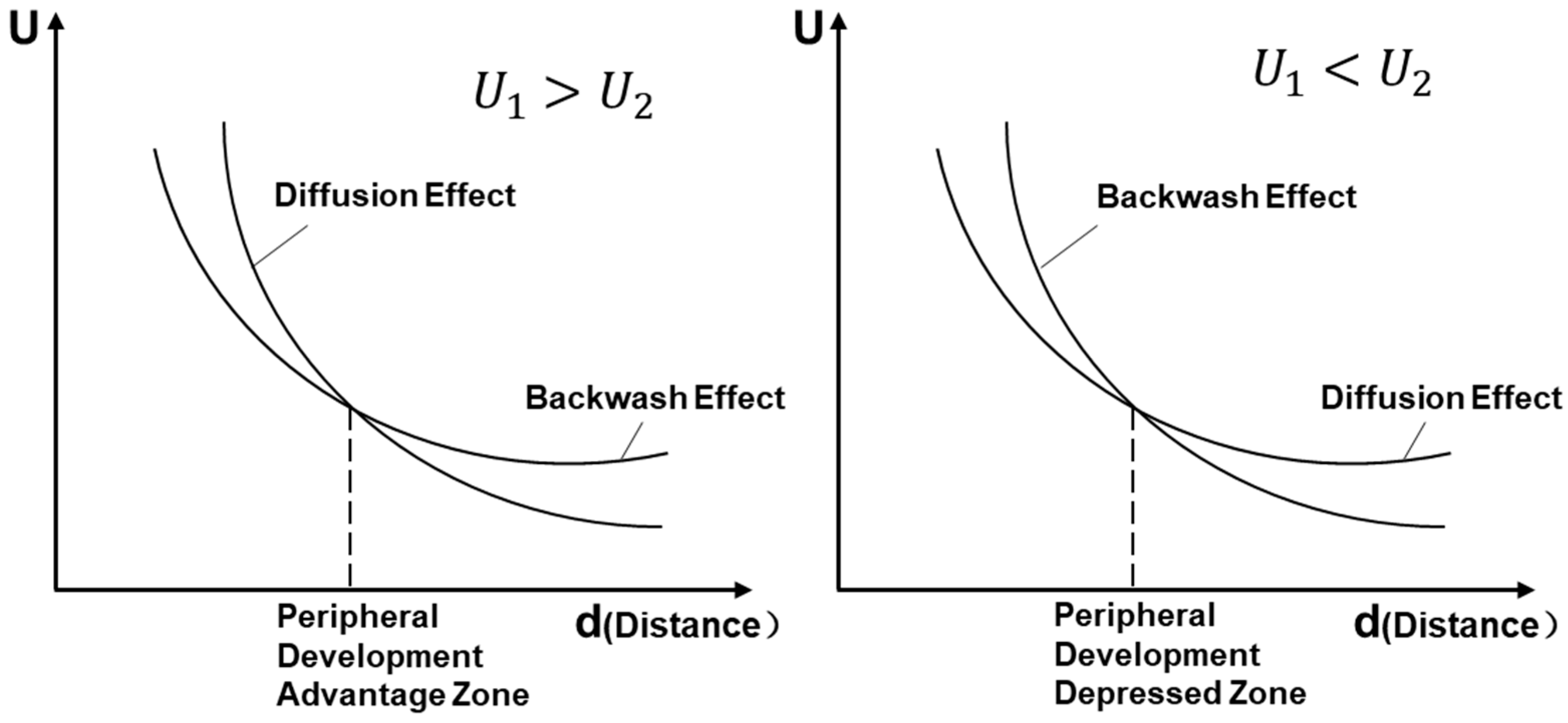
2. Literature Review

Urban interstitial areas, serving as crucial frontiers of urban functional agglomeration and diffusion processes, have increasingly emerged as zones of developmental significance amid ongoing decentralization and regional integration. These transitional spaces, known as “gaps” or “interstices”, simultaneously benefit from positive externalities radiating from metropolitan cores and lower land costs. Initially, urban interstices were seen as passive or residual spaces at the peripheries of major urban centers, and they were often overlooked in mainstream urban theory [3,6,21]. Within contemporary globalization and polycentric urban restructuring, such distinctive spatial entities have attracted interdisciplinary scholarly attention with respect to geography, urban planning, and sociology [4,5,6,8,13,18,22,23,24,25,26].
A key theoretical framework underpinning the development of urban interstitials is the research of Gunnar Myrdal (1957), who is associated with classical regional economic theory; specifically, his concepts of “diffusion” and “backwash” effects are of particular relevance [27]. The research of the Myrdal model describes how urban centers exert both positive externalities (diffusion effects) and negative forces (backwash effects) on the surrounding peripheral areas. Diffusion effects refer to the outward flow of benefits and development from urban cores, while backwash effects describe the inward pull of resources, labor, and capital toward these centers. The balance between these effects helps explain the uneven development of interstitial areas, where peripheral spaces experience either intensified development or underdevelopment depending on the relative strength of diffusion and backwash effects. This framework provides valuable insights into how urban interstices evolve (Figure 1), as they often experience both types of effects simultaneously—being shaped by the external influence of core cities while still maintaining distinct spatial and administrative characteristics [22,28].
Following the research of Myrdal, more scholars have turned to the empirical realities of interstitial urban spaces, revealing that they are far from simply marginal, residual, or vacant [22,29,30,31]. Instead, these spaces are increasingly recognized as loosely regulated yet highly plastic and relational areas that challenge conventional urban models. Their partial formalization, pending status, and embeddedness within infrastructure, governance, and ecological networks make them fertile ground for rethinking urbanization processes beyond traditional center–periphery dichotomies [22,32,33,34,35]. As Phelps and Silva (2018) argue, interstices function across multiple spatial scales and reflect the unresolved tensions between planning and informality, and development and stasis [3]. These attributes position interstitial areas as laboratories for emergent urban forms and key sites for theorizing new urbanity under the conditions of decentralization, fragmented governance, and socioeconomic restructuring [4,8,14,18,36]. The shift from viewing these spaces as “leftover” to understanding them as productive and strategic urban frontiers has given rise to a growing body of interdisciplinary literature that reconceptualizes interstices as central to the contemporary urban condition [37,38,39]. Among this emerging body of work, several scholars have provided foundational conceptualizations that further illuminate the nature and significance of interstitial spaces. Silva, for instance, reconceptualized these areas beyond merely vacant or residual zones, emphasizing their role as dynamic environments characterized by distinct socioeconomic activities, ecological diversity, and functional evolution [18,21]. Similarly, Gandy highlighted the multifunctional nature of urban interstitials, focusing on their role in providing ecological resilience and cultural preservation in the interfaces between cities [30]. Complementing these perspectives, Sieverts’s notion of Zwischenstadt (in-between cities) captures the hybrid spatiality of such zones, which transcend conventional urban–rural divides and embody diverse land-use configurations shaped by regional transportation networks and governance ambiguity [25]. Together, these studies ground the theoretical reimagining of interstitial spaces as complex, dynamic, and integral components of the urban system rather than peripheral anomalies.
The rapid urbanization of China and its distinctive institutional contexts have significantly contributed to the emergence of indigenous theoretical perspectives on interstitial urbanization. Many cities have emerged at the boundaries of metropolitan cores, experiencing administrative fragmentation despite strong functional integration with nearby urban centers. This phenomenon has drawn significant interest from Chinese scholars, who have systematically examined these interstices through the multidimensional analyses of their spatial delineation, structural characteristics, functional attributes, and evolutionary dynamics. Zhang Jingxiang (2000) first introduced the influential concept of “metropolitan shadow regions” based on empirical evidence from the Yangtze River Delta. He demonstrated how administrative barriers and hierarchical governance structures resulted in “polarization-shadow effects”, wherein higher-tier urban centers exert suppressive impacts on neighboring lower-tier areas, effectively restricting their developmental potential [9]. Building on these ideas, Sun Dongqi further examined how urban interstitials in the Beijing–Tianjin–Hebei region could evolve into “developmental opportunity windows” under favorable conditions. Sun argued that, while these regions often faced administrative fragmentation, they also held significant potential for growth if they could leverage infrastructure investments and favorable policies. His work highlighted the transformative potential of these regions, which could bridge the gap between core cities and peripheral areas [40]. In addition to these foundational studies, Sun Jianxin et al. quantitatively explored the effects of administrative boundaries on the mobility of developmental factors in Chinese urban regions. They identified administrative fragmentation as a key barrier to regional integration and the flow of human capital, economic resources, and technological innovation between cities. Their research highlighted the need for more coordinated governance strategies to facilitate the functional integration of urban interstices into broader urban systems [7]. Technological advancements in data collection have also played a significant role in the development of urban interstice research in China. Yang Junyan pioneered an innovative multidimensional identification framework for interstitial spaces using mobile signaling data and POI (point of interest) big data. Yang’s research introduced a dual-dimensional model combining population mobility and commercial activity patterns, which enabled a more nuanced understanding of the spatial and functional characteristics of urban interstices. His research was instrumental in shifting the focus from purely qualitative analysis to a more empirical and data-driven approach to studying urban interstitials [28]. Similarly, Hu Xinyu et al. explored how local land policies and industrial distribution gradients contribute to differentiated morphological development patterns within the interstitial areas of Chinese megacities, reinforcing the importance of administrative governance in shaping spatial outcomes [41]. Such research underscores the fact that urban interstices are not passive recipients of metropolitan spillovers, but dynamic development frontiers that are actively shaped by policy gradients and economic processes.
In the specific Chinese institutional context, the emergence and growth of interstitial urban areas are strongly influenced by administrative jurisdictions, governance fragmentation, and targeted policy interventions. Industrial spillovers from metropolitan cores interact dynamically with administrative boundaries and local policy gradients, including differential land pricing, tax incentives, and flexible land quota allocations [7,9,42,43,44,45]. Such administrative gradients enable interstitial zones to become “positive externality sinks”, capturing technological spillovers and shared infrastructure resources from core urban areas. Over time, these transitional zones evolve into distinct hybrid spaces characterized by low production costs and substantial external benefits, a phenomenon that differentiates Chinese interstitial urbanization from Western models dominated by market-driven processes. The development of Kunshan, a county-level city administratively subordinate to Suzhou, exemplifies this unique interplay [46,47]. Kunshan capitalized upon the electronics industry’s spillovers and its flexible land-transfer policies in Shanghai, successfully developing into a low-cost, high-growth industrial enclave. This strategy, termed “economic stitching across administrative fractures”, highlights the institutional dividends uniquely attainable within fragmented governance structures, ultimately transforming administrative boundaries from barriers into bridges for regional integration and economic growth (Figure 2).
Despite these theoretical and methodological advancements, existing research on urban interstices remains predominantly conceptual or limited to isolated case studies. Few studies systematically quantify the spatial dynamics, connectivity patterns, and evolutionary trajectories of urban interstices at broader metropolitan scales. This methodological limitation has constrained the holistic understanding of interstitial urbanization processes. However, recent technological innovations, especially the application of mobile phone signaling data, have significantly transformed analytical capacities. Mobile signaling datasets, capturing the continuously temporal and detailed spatial patterns of population movements, provide unprecedented opportunities for the quantitative analyses of intercity connectivity and functional integration across extensive geographical scales [48,49,50]. These methodological advancements not only bridge existing research gaps, but also establish robust frameworks for systematically investigating urban interstitial spaces, thereby laying foundations for future comprehensive and comparative analyses.

3. Methodology and Materials

This study adopts a single-case, data-driven empirical design to investigate Jurong City as a representative example of an “urban interstice”. Positioned between the major metropolitan centers of Nanjing and Zhenjiang, Jurong exemplifies the spatial and institutional tension characteristics of urban interstices—cities that are functionally integrated with nearby cores but constrained by administrative fragmentation. This study employs a combination of mobile phone signaling data and origin–destination (OD) flow analyses to capture the directionality, intensity, and spatial selectivity of intercity mobility patterns. This methodological framework enables a quantitative assessment of the integration within the broader regional system in Jurong. The remainder of this section details the data sources, processing techniques, and spatial analytical procedures adopted in this study.

3.1. Methodology

3.1.1. Data Rationale and Technical Superiority

As an indispensable tool in modern life, mobile phones provide a reliable foundation for population data acquisition through signaling records. In China, 99.8% of Internet users access services via mobile devices, ensuring the near-universal coverage of signaling data. Originating from the 1990 studies pioneered by the University of Maryland and INRETS, mobile positioning technology has evolved into a robust tool for mapping population distributions and mobility patterns [51]. Francesco Calabrese et al. demonstrated its efficacy through dynamic OD matrix estimation using 1 million user records in the Boston Metropolitan Area [52]. Chinese scholars like Niu Xinyi established technical frameworks for megacity spatial planning using signaling data, addressing key urban issues including population distribution, commuting patterns, and job–housing balance [53]. This study utilizes mobile phone signaling big data to measure human mobility and comprehensively analyze the development dynamics of interstitial urban spaces, providing scientific support for urban planning. Mobile phone signaling data are collected by telecommunication operators during routine network maintenance, recording the geographical location information of mobile users. Specifically, base stations track user activities—such as powering on/off, making calls, sending and receiving text messages, and other network interactions in real time—generating signaling data at intervals of 5 to 10 min. Each signaling record contains a timestamp, spatial coordinates, and the socioeconomic attributes of the user, forming a complete dataset of individual movement trajectories and stay points.
By aggregating and integrating massive volumes of mobile phone signaling data, a population movement trajectory database with spatiotemporal continuity and comprehensive spatial coverage can be constructed. Compared to traditional static statistics or travel frequency data, mobile phone signaling data exhibit superior real-time characteristics, dynamic adaptability, and continuity [49,50,54]. With a spatial resolution typically ranging from 200 to 1000 m, these data enable the precise localization of users’ actual activity locations, facilitating an efficient mapping of human spatiotemporal behaviors onto geographic space [55]. Consequently, mobile phone signaling data serve as a scientifically robust foundation for quantifying intercity human mobility, offering a precise method to assess developmental linkages between interstitial urban spaces and their surrounding cities.

3.1.2. OD Connection

To evaluate the strength of linkages between Jurong and its neighboring cities, we developed three metrics based on origin–destination (OD) flow analysis: total flow volume, relative intensity, and flow balance.
(1) Total flow volume
The total flow volume measures bidirectional human mobility between cities (Figure 3). For two cities A i and B i , the following equation is used:
V A i B i = V B i A i = T A i B i + T B i A i
where
T A i B i denotes the daily flow from origin A i (primary residence) to destination B i ;
T B i A i denotes the daily flow from origin B i (primary residence) to destination A i .
(2) Relative Intensity
This metric normalizes the flow volume relative to the population scale to assess the linkage strength:
Q A i B i = V A i B i / P A i V B i / P t o t a l
where
V A i B i denotes the total bidirectional flow between A i and B i ;
P A i denotes the permanent population of A i ;
V B i denotes the total bidirectional flows between B i and all A connected cities;
P t o t a l denotes the combined population of all A cities.
(3) Flow Balance
This index quantifies the flow symmetry between cities:
X a = T B i A i T A i B i T B i A i + T A i B i

3.1.3. Kernel Density Estimation

In addition to numerical indices, we conducted a spatial analysis to visualize the distribution of population activity across the region. We applied kernel density estimation (KDE) on the origins of trips (primarily the home locations of core users) to map out the population density pattern from Nanjing to Jurong. KDE is a non-parametric method that creates a smooth surface, highlighting where the concentrations of points (in this case, residents) are highest. Using ArcGIS, we converted the home locations of users into point data and generated a kernel density surface over the study area. This helps illustrate the gradient of the population settlement and activity intensity extending outward from Nanjing to the territory of Jurong. We then overlaid the major OD linkages on this density map to identify key nodal areas—places in Jurong or Zhenjiang that emerge as hotspots of interaction with Nanjing. Moreover, at the township level (Jurong is divided into 12 townships), we summed the OD flow volumes between each Jurong township and Nanjing/Zhenjiang. This allowed us to classify parts of Jurong by their connectivity: for example, which townships have the highest exchange with Nanjing versus which are more isolated. By combining the density and OD connectivity analyses, we can discern spatial patterns and disparities within Jurong, essentially mapping the internal structure of this urban interstice in relation to its neighbors.
h x = 1 n i = 1 n K h x x i = 1 n h i = 1 n K x x i h

3.2. Study Area

Jurong City (118°57′~119°22′ E, 31°56′~32°13′ N), located in central Jiangsu Province along the southern bank of the Yangtze River, serves as the paradigmatic case for this research. Geographically positioned between the regional cores of Nanjing and Zhenjiang (Figure 4), Jurong exemplifies a typical interstitial urban area within the polycentric urbanization framework of the Yangtze River Delta. Administratively subordinate to Zhenjiang, Jurong has strategically aligned its development trajectory toward Nanjing through the “Integration into Nanjing, Coordination with Zhenjiang” regional policy, reflecting both the city of Nanjing’s expanding metropolitan influence and local political–economic ambitions driven by the political achievement tournaments in China [56,57]. Its strategic location presents a distinctive interstitial spatial configuration, characterized by three key functional roles in Jurong:
  • Metropolitan Integration Zone (Gain access via https://www.jurong.gov.cn/jurong/c100278/202111/f0835b2fd71a4a52b9b75f9ecb3482cc.shtml, accessed on 20 February 2025): As the eastern gateway of the Nanjing metropolitan core, Jurong serves as an experimental pilot area for absorbing decentralized urban functions from the urban core of Nanjing City, facilitating metropolitan-scale functional integration.
  • Regional Exchange Hub [58]: Reflecting its central role within the Ning–Zhen–Yang Integrated Development Plan (2018), Jurong is located at the intersection of Nanjing, Zhenjiang, and Yangzhou. It is officially designated as an anchor city along the Ning–Zhen Development Axis.
  • Spatial Frontier for Metropolitan Expansion: Jurong is situated approximately 40 km northeast of the central business district in Nanjing (Xinjiekou CBD), within a 45 min commuting radius, positioning it as a critical frontier for the suburban growth and spatial extension of Nanjing.
These roles encapsulate the complex identity characterized by administrative fragmentation yet strong functional integration in Jurong, providing an ideal setting for analyzing the spatial externalities inherent to urban interstitial zones.
To quantitatively capture real-world spatial interactions and mobility patterns between Jurong, Nanjing, and Zhenjiang, this study utilizes anonymized mobile phone signaling data obtained from the “Wisefoot” (Smart Steps) big data platform of China Unicom. The dataset encompasses a one-month period (1–30 November 2019) and comprises spatial location records from mobile devices within the jurisdictions of Jurong, Nanjing, and Zhenjiang. The raw mobile signaling data were systematically processed into structured origin–destination (OD) travel information following a rigorous three-step methodology (outlined in Figure 5).
  • Core user identification: Initially, we filtered signaling data to define the core population in Jurong. A core user was operationally defined as a mobile device that registered presence within the administrative boundaries for more than ten days within the analysis period (November 2019) in Jurong. This threshold ensures that the identified core users are stable residents or regular commuters rather than transient visitors or incidental passersby. Spatial location data were aggregated onto a standardized grid structure of 1 km × 1 km resolution, balancing spatial precision and computational feasibility. Users identified as present for ten days or fewer were classified as transient visitors and excluded to minimize analytical noise from occasional or short-term mobility events.
  • Derivation of home, work, and other destinations: Subsequently, we derived primary home locations, workplaces, and other significant activity locations for each core user. Home locations were determined by identifying the grid cell with the highest cumulative dwell time during nighttime hours (21:00–08:00). Workplace locations were similarly determined by locating the grid cell exhibiting the longest cumulative daytime dwell time during weekdays (09:00–17:00), excluding home locations. If daytime and nighttime locations coincided—indicative of individuals working from home or those without distinct external workplaces—the second-most frequent daytime location was evaluated. If this secondary location represented a substantial proportion of daytime presence (set by a predefined time threshold), it was designated as the workplace. In cases where no suitable secondary daytime location existed, users were categorized as having no distinct workplace, reflecting patterns characteristic of retirees or home-based occupations. Additionally, other significant activity locations such as shopping areas, educational facilities, or recreational venues were identified using a dwell-time threshold criterion (continuous presence exceeding one hour). By sequencing these locations chronologically, complete daily mobility chains for each user (e.g., Home → Destination 1 → Destination 2 → Home) were constructed, facilitating comprehensive OD trip identification.
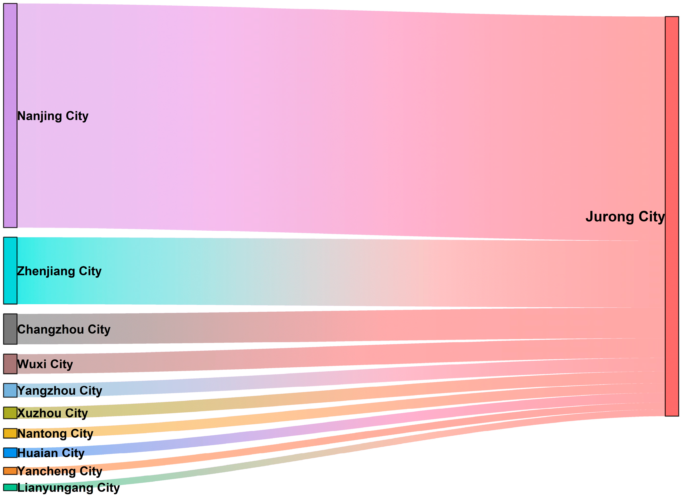
  • Extraction of intercity OD flows: In the final step, we extracted intercity OD trips involving Jurong and its neighboring cities, Nanjing and Zhenjiang. Specifically, trips were selected where either the origin or destination (or both) was located within the administrative boundary in Jurong, with the corresponding origin/destination located in Nanjing or Zhenjiang. Intra-city movements (origin and destination within Jurong only) and trivial movements involving non-core visitors were excluded. This filtering procedure isolated intercity mobility flows within the tri-city area (Jurong–Nanjing, Jurong–Zhenjiang, and, for contextual reference, Nanjing–Zhenjiang). The resulting dataset comprised approximately 1.54 million OD records over a representative week-long sampling period (10–16 November 2019). Among these, approximately 1.22 million OD records directly involved the core users in Jurong. Each OD record included information on the origin grid, destination grid, and an anonymized user identifier, enabling detailed spatial aggregation and mobility pattern analyses.
This refined OD dataset enabled the quantification of precise intercity mobility metrics such as daily commuter volumes from Jurong to Nanjing and Zhenjiang, reciprocal inflows from these cities to Jurong, and the spatial distribution patterns of regional interactions. Consequently, these data provide robust empirical support for analyzing integration dynamics, administrative fragmentation impacts, and spatial–functional roles as an emerging urban interstice in Jurong.

4. Results and Analyses

4.1. Characteristics of Population Flow in Jurong City

The population is highly connected with the surrounding Jiangsu province in Jurong, especially with the neighboring metropolis of Nanjing. Our analysis of approximately 1.54 million intercity trip records highlights that the external population movements of Jurong are predominantly concentrated within the neighboring metropolis, Nanjing. According to the OD flow analysis, Nanjing accounts for approximately 60% of all external trips linked to Jurong, far exceeding interactions with Zhenjiang—the administrative jurisdictional parent city—which accounts for around 15.6% of the total trips. Notably, Shanghai, a nearby megacity, also significantly influences the mobility patterns of Jurong, contributing approximately 15.6% of inbound trips. In total, nearly half (49%) of the visitors to Jurong originate from Jiangsu Province, reaffirming that regional mobility networks dominate population exchanges involving Jurong (Figure 6).
This concentrated mobility pattern indicates that Jurong primarily functions as a recipient and redistribution node for metropolitan spillovers from Nanjing, significantly more so than from its administrative parent, Zhenjiang. Consequently, Jurong has a clear functional dependence on Nanjing, reflecting substantial metropolitan integration despite administrative fragmentation (Figure 7).

4.2. Quantitative Analysis of OD Connectivity

To quantify the connectivity of Jurong with adjacent cities, we calculated three metrics based on OD analyses: total flow volume, relative connectivity intensity, and flow balance (Table 1, Figure 8).
  • Total flow volume: The Jurong–Nanjing connection dominates regional interactions, constituting 45.2% of all OD trips, with approximately 78,900 weekly intercity trips recorded. In contrast, Jurong–Zhenjiang flows total approximately 54,900 trips (31.5% of total flows), while direct flows between Nanjing and Zhenjiang only total about 40,800 trips (23.3%). This pattern reveals the critical intermediary role in regional connectivity in Jurong, capturing interactions that may otherwise bypass its territory.
  • Relative connectivity intensity: The relative intensity index normalizes flows according to population size, enabling an unbiased comparison across city pairs. Jurong–Nanjing has an exceptionally high connectivity intensity of 2.18, significantly exceeding the baseline (1.0) and indicating highly intensive functional integration with Nanjing. The Jurong–Zhenjiang interaction is lower (1.15), reflecting modest integration relative to administrative ties, and the direct linkage between Nanjing and Zhenjiang remains notably weaker (0.59).
  • Flow balance: The flow balance metric quantifies the directionality and symmetry of flows. For Jurong–Nanjing, the balance is −0.082, signifying a moderate net outflow of commuters from Jurong toward Nanjing. Similarly, Jurong–Zhenjiang has a slight net outward flow (−0.048), indicative of the function of Jurong’s dependence on its neighbors for employment and specialized services. Conversely, direct flows between Nanjing and Zhenjiang are nearly symmetrical (+0.009), confirming the centrality of Jurong as an intermediary node in regional interactions.

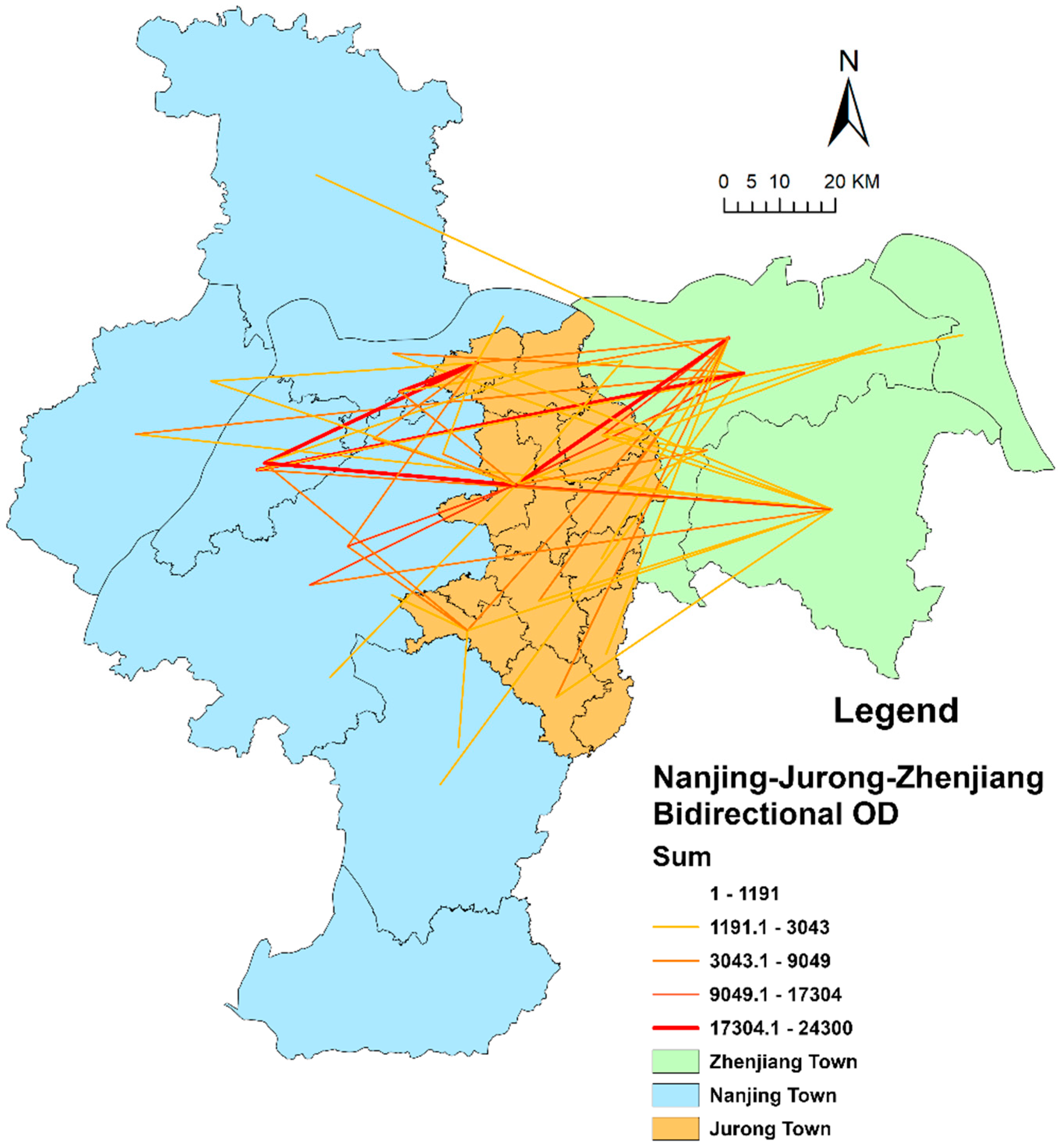
4.3. Spatial Structure of Linkages and Node Identification

Beyond aggregate flows, our analysis examined the spatial distribution of intercity connectivity within Jurong. By mapping the OD flows at the 1 km grid level, we identified specific locations in Jurong that serve as key conduits for travel to and from Nanjing or Zhenjiang. The results reveal a highly uneven internal connectivity geography in Jurong.
Figure 9 illustrates the density of intercity travel origins and destinations across the Nanjing–Jurong–Zhenjiang area. The flows between the three cities tend to concentrate in a few hotspots rather than being uniformly spread. As expected, the highest density of trips linking to Jurong (and Zhenjiang) originates from the main urban core of Nanjing (notably, downtown districts such as Gulou and Xuanwu). This reflects that many of the people traveling to Jurong from Nanjing are based in the city center or major hubs of Nanjing (where jobs and universities are concentrated). In Zhenjiang, there is a modest concentration of trips in the city center connecting to Jurong, but, interestingly, this does not stand out as a high-intensity cluster on the map. In other words, the volume of travel between the core of Zhenjiang and Jurong, while present, is not sufficient for creating a “bright” hotspot that is comparable to those observed in Nanjing or Jurong. This again underscores the secondary nature of the interaction between Zhenjiang and Jurong.
Within Jurong itself, two primary intercity connectivity clusters emerge: Jurong city center and Baohua Town (in the northwestern part of Jurong) (Figure 9). These two areas exhibit the highest density of incoming and outgoing intercity trips. The city center of Jurong, which is the administrative and commercial heart of the city, naturally functions as a collection and distribution point for travel—it is where major roads intersect and where many people live or work; thus, many trips either start or end here. Baohua Town, on the other hand, is a township on the western edge of Jurong, directly bordering the Nanjing metropolitan boundary (near the Qixia District of Nanjing, which includes the Xianlin University Town area). The data reveal that Baohua has developed into a significant gateway for Nanjing–Jurong interactions. In fact, the Baohua area and the adjacent Nanjing Xianlin sub-district together form a continuous high-mobility zone, indicating a seamless spillover of urban influence from Nanjing into the territory of Jurong at that location. This is likely due to the proximity of Baohua to the suburbs of Nanjing and the presence of convenient highways (and possibly a commuter rail station) linking Baohua with the downtown area of Nanjing within a short travel time. As a result, Baohua has attracted residential developments and commuters who effectively live in Jurong but work or study in Nanjing.
To systematically assess and categorize the subregions of Jurong based on their connectivity patterns, we analyzed each of its 12 units, comprising four streets and eight towns, using two key metrics: the total volume of intercity trips (combined flows to Nanjing and Zhenjiang) and the directional balance of these connections (whether flows are predominantly oriented toward Nanjing, Zhenjiang, or both). The findings reveal distinct spatial patterns, which can be summarized as follows (Table 2, Figure 10):
  • High-potential node areas: The central city of Jurong (urban core) and Baohua Town clearly fall into this category. They each have the highest total intercity flow volumes, and they also each maintain multiple strong linkages. The city center of Jurong, for instance, sends and receives large flows from multiple directions—it connects robustly with the main city districts of Nanjing and the central district of Zhenjiang and even has notable interactions with other nearby cities such as Danyang (an adjoining city under the jurisdiction of Zhenjiang). The connections of Baohua Town are somewhat one-sided—primarily oriented toward areas near Nanjing, such as Xianlin and Jiangning District—but due to the high volume of flows, Baohua ranks as a crucial node anchoring the Nanjing–Jurong linkage. Both the central city and Baohua function as major interchange points, where people transition between the local context of Jurong and the broader regional context. For example, a traveler from another part of Jurong might first proceed to the city center before continuing to Nanjing, or vice versa.
  • Moderate connectivity nodes: A number of other towns show intermediate levels of linkage in Jurong. Notably, Guozhuang Town (southwest Jurong) and Xiashu Town (southeast Jurong) have moderate but non-negligible flows connecting them outward. Guozhuang, located along a provincial highway that leads toward Zhenjiang and is also not far from the southern outskirts of Nanjing, has a decent amount of travel, especially relative to Nanjing. Xiashu, closer to the eastern side of Jurong, also has some interactions. These towns each tend to have a stronger connection in one direction; for example, Guozhuang is more oriented to Nanjing due to direct road links, while Xiashu is relatively more oriented toward Zhenjiang. While they participate in regional interchange, we classify these as secondary nodes occurring at a lower magnitude or more one-directionally.
  • Low-connectivity areas: The remaining townships in Jurong, particularly those farther from the Nanjing–Jurong main corridor (e.g., in the far south, such as Maoshan, or the far northeast), exhibit very low intercity flow counts. They neither send nor receive many regional trips. These places are currently not significant players in Nanjing–Jurong–Zhenjiang interactions. They may be more agriculturally oriented or lack major transport hubs and thus continue to function largely outside the daily urban field of the major cities.
This spatial heterogeneity has important implications. It suggests that the integration of Jurong into the regional system is occurring along specific corridors. In particular, the data highlight a primary corridor running roughly west to east through the central area of Jurong: from the main urban core and Xianlin area of Nanjing into Baohua and then to the downtown area of Jurong, further proceeding east toward Zhenjiang (via the town of Biancheng and onward to Danyang, a city under the jurisdiction of Zhenjiang). This pattern aligns with the trajectory of major infrastructure such as the Huning Expressway (Shanghai–Nanjing Highway), which traverses this alignment. Another corridor proceeds from the north to the south, connecting the Tangshan area in eastern Nanjing, through Huangmei (a town in northern Jurong), to the central part of Jurong along Provincial Road S122. These corridors are visualized in Figure 11, identifying the key linkage routes and nodes. Essentially, the role of Jurong as an urban interstice is being solidified along these axes, where infrastructure and spatial proximity facilitate movement.
Based on these findings, we can begin to outline a typology of development nodes and corridors for the Ning–Ju–Zhen region:
  • Core interchange hubs: The main urban area of Nanjing, the central district of Jurong, and the urban area of Zhenjiang constitute the primary functional anchors. Among them, the central district of Jurong functions as the pivotal intermediary hub connecting the other two cities.
  • Secondary gateways: Baohua Town operates as a gateway through which the functional influence of Nanjing extends into Jurong, effectively serving as an extension of the Nanjing metropolitan zone while also directing urban growth into Jurong. In the southwestern part of Jurong, Guozhuang Town plays a similar, albeit smaller, role as a connector to the southern peripheral areas of Nanjing.
  • Supporting nodes: Towns such as Huangmei (north Jurong, on S122), Biancheng (east Jurong, on the highway to Danyang), and perhaps others, such as Xiashu, help connect local areas into the main corridors but have more limited roles.
  • Potential development corridors:
    Tangshan–Huangmei–Jurong City Corridor: This north–south corridor (following S122) is already taking shape as both Nanjing and Jurong develop toward each other along this route.
    Nanjing–Huangmei–Biancheng–Danyang Corridor: An east–west corridor along the expressway linking Nanjing to Danyang (via Jurong) has high accessibility and has the potential to form a continuous development belt connecting the three cities.
    Southern extensions: There is potential to extend connectivity further south within Jurong, for instance, improving linkages from the center of Jurong down to Guozhuang (via provincial road S243) and onward, or extending the S122 corridor southward to better integrate the Maoshan area. These actions could incorporate currently peripheral areas into the regional network.
Identifying these spatial patterns and corridors helps inform where future growth and infrastructure investment could be directed to maximize regional integration. The data-driven connectivity map of Jurong points to the Nanjing-facing side of Jurong (Baohua, Huangmei, etc.) as the key avenue of interaction, which suggests that planning efforts should prioritize those zones for transit improvements, industrial parks, or housing that caters to cross-boundary commuters. Meanwhile, the eastern Jurong connection toward Zhenjiang, while less pronounced, is still significant and could be enhanced, ensuring that Jurong does not exclusively become a suburb of Nanjing but also continues to interface with Zhenjiang in a balanced manner (Figure 11).

5. Discussion

The case of Jurong City, as revealed by the above results, provides a concrete illustration of how an urban interstice evolves and functions under the dual forces of metropolitan expansion and administrative fragmentation. Several key points emerge from the findings that warrant further discussion in light of broader urban theory and planning considerations.

5.1. Quantifying Urban Interstices: Methodological Innovation and Governance Fragmentation

We respond directly to the call by Phelps and Silva (2018) in “Mind the Gaps! A Research Agenda for Urban Interstices”. The publication emphasizes the critical but understudied role of urban interstices in contemporary urbanization processes [3]. This study employs quantitative methodologies, specifically mobile signaling data and origin–destination (OD) flow analysis, to measure spatial connectivity and functional integration in a fragmented governance environment.
Unlike most prior interstice studies that rely on qualitative or conceptual approaches [4,21,36,59], this research quantitatively captures population mobility and spatial interactions, thereby enhancing methodological rigor and comparability across cases.
Secondly, this study highlights the unique characteristics of urban interstices under Chinese distinctive administrative governance systems and state-led urbanization contexts, contrasting with Western models that are primarily driven by market mechanisms. In China, this phenomenon stems from the country’s hierarchical administrative structures and political tournament system, shaping interstitial urban spaces that are distinctly different from those in Western contexts [56,60,61,62]. The development of Chinese urban interstices is heavily mediated by administrative boundaries and local governance priorities. This form of administrative fragmentation results in governance mismatches, where local governments, incentivized by economic competition and political evaluations, strategically align with more economically dynamic metropolitan cores rather than their nominal administrative superiors [63,64]. Thus, this study significantly enriches the global theories of urban interstices by incorporating the critical dimension of governance fragmentation and its interplay with metropolitan spillovers.
Furthermore, the analysis shows that urban interstices are not passive spillover zones, but active agents of regional restructuring. Mobility is concentrated along infrastructure-rich corridors and key transit nodes, notably the city center and Baohua Town, while other areas exhibit weaker connections. Together, these insights contribute to a more nuanced understanding of urban interstices under fragmented governance while offering a foundation for future studies on cross-jurisdictional integration, comparative urban governance, and interstitial dynamics over time.

5.2. Navigating Governance Mismatches: Functional and Strategic Integration of Jurong and Nanjing

The case of Jurong highlights the governance challenges of managing spatial development across fragmented jurisdictions. Despite its administrative subordination to the city of Zhenjiang, Jurong is deeply functionally integrated with the city of Nanjing, as reflected in the high share of cross-city travel. This has created a governance mismatch, where local policies and planning orientations align more with the economic pull of Nanjing than with the administrative structure of Zhenjiang. Field observations and policy documents further show that Jurong consciously embraces this duality: aiming for deeper integration with Nanjing while maintaining formal autonomy within the jurisdiction of Zhenjiang. Strategic areas such as Baohua Town and Guozhuang Town have been positioned to absorb the spillovers from Nanjing—whether with respect to residential demand, innovation functions, or industrial relocation—demonstrating the proactive adaptation strategy of Jurong (Figure 12).

5.3. Re-Evaluating the Role of Urban Interstices

This study reveals that urban interstices such as Jurong are not peripheral bystanders, but active nodes shaping regional spatial structures. The position of Jurong between Nanjing and Zhenjiang enables it to play a strategic mediating role—integrating not only into the metropolitan system of Nanjing, but also bridging two cities that otherwise exhibit weak direct ties.
The empirical findings show that Jurong–Nanjing mobility flows are dominant (45.2%), whereas direct Nanjing–Zhenjiang flows are relatively limited (23.3%). However, Jurong maintains consistent movement with Zhenjiang, suggesting a triangular interaction structure in which Jurong serves as a functional hinge. Its presence absorbs, channels, and redistributes flows that might otherwise bypass Zhenjiang entirely.
However, this integrative function is not a product of coordinated metropolitan planning but a consequence of the development agency of Jurong itself. Despite administrative subordination to the city of Zhenjiang, the local government of Jurong actively aligns with Nanjing, reflecting the gravitational pull of economic opportunities and connectivity. Towns such as Baohua and Guozhuang are positioned to absorb the spillover from Nanjing with respect to residential, technological, and industrial functions. For instance, Baohua is being linked to Xianlin Science City and the Kylin Science and Technology Park, while Guozhuang leverages its proximity to Lukou Airport to connect with the advanced manufacturing base of southern Nanjing. In contrast, the weak institutional incorporation of Jurong by Zhenjiang—due to administrative fragmentation—means that critical infrastructure and development policies often bypass regional coordination. Many of the key projects in Jurong have been realized through self-led financing or cooperation with Nanjing rather than through top-down integration within the planning framework of Zhenjiang. For example, the transportation of the Nanjing–Jurong Intercity Line S6 is the first intercity subway project undertaken by Nanjing, and the education project of the Nanjing Foreign Language School is implemented in Xianlin Branch Baohua Kindergarten. Thus, the functional integration of Jurong outpaces its formal governance alignment, highlighting a common dilemma faced by urban interstices.

6. Conclusions

This study quantitatively examines the interplay between administrative fragmentation and functional integration in Jurong, a typical urban interstice in the rapidly urbanizing Yangtze River Delta. Leveraging mobile OD flow data, we systematically analyze inter-city mobility, regional connectivity, and spatial interaction patterns, providing empirical insights into the dynamics of urban interstices. Jurong exemplifies the dual nature of urban interstices—absorbing metropolitan spillovers from Nanjing while remaining institutionally bound to Zhenjiang. This spatial–functional mismatch reveals how urban flows increasingly transcend administrative boundaries, challenging traditional governance frameworks. The emergence of subcenters like Baohua (residential) and Guozhuang (innovation) along infrastructure-rich corridors reflects a corridor-based, polycentric development mode. Jurong’s alignment with Nanjing, despite limited support from its administrative center, further illustrates how governance fragmentation can prompt bottom-up integration strategies, though often at the cost of formal policy coherence.
Theoretically, this study contributes to the evolving understanding of interstitial urbanization, particularly under state-led governance regimes. It introduces a relational perspective that emphasizes functional flows over static territorial hierarchies, situating urban interstices as dynamic mediators within fragmented spatial structures. Methodologically, the use of mobile signaling data offers a replicable approach to identifying and quantifying inter-urban linkages, providing an evidence-based lens through which to understand the real-time dynamics of urban connection. It also presents the following practical policy implications:
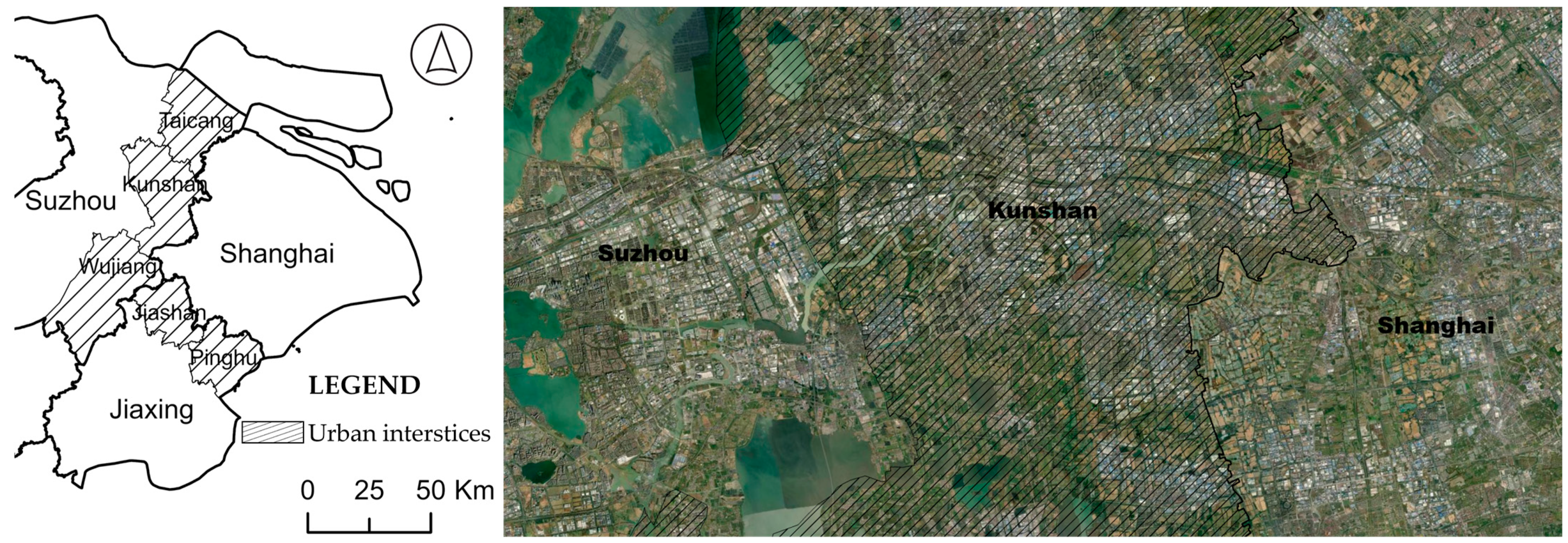
  • In China, the case of Jurong points to the importance of recognizing interstitial cities as strategic actors within larger urban agglomerations. Comparable cases such as Kunshan (Suzhou)–Shanghai and Pinghu (Zhejiang)–Shanghai suggest that governance and planning reforms should more explicitly account for high-mobility corridors that defy existing administrative delineations (Figure 13). This spatial selectivity underscores the necessity for targeted infrastructural investment and highlights the active agency of urban interstices in regional spatial restructuring. Tools such as joint metropolitan planning institutions, cross-jurisdictional zoning schemes, or flexible land-use frameworks can enable these areas to participate more meaningfully in regional coordination and resource allocation.
  • Internationally, these findings are applicable to fragmented metropolitan regions such as Cheshire East and Stockport in the UK, and Greater Tokyo in Japan, where spatial–functional integration is increasingly misaligned with administrative jurisdictions. In such systems, administrative cooperation and functional zoning can help reconcile governance mismatches with emerging spatial interactions shaped by commuting, service use, and cross-border economic flows. For example, the UK’s Localism Act (2011) mandates local governments to engage in strategic planning cooperation through the “Duty to Cooperate” framework [65,66], reflecting institutional efforts to mitigate fragmentation without redrawing boundaries. By employing mobile phone signaling data—similarly to the methods used in this study—planners can quantitatively capture real-time population flows across fragmented governance territories. This enables the evidence-based identification of emerging spatial–functional linkages that may not be visible through traditional administrative datasets and supports more responsive, dynamic governance models. Accordingly, the spatial strategy should match the pattern of human flows and local constraints. In areas with stable, high-volume directional commuting, infrastructure investment (e.g., transit corridors, intercity rail) can consolidate linkages. In contrast, where long-distance commuting reveals regional imbalance or capacity pressure, developing new subcenters closer to residential areas may reduce dependency on core cities and improve spatial equity. Recognizing urban interstices along these corridors as de facto integration nodes allows planners to calibrate interventions to specific spatial realities. This situation calls for new governance frameworks that transcend rigid administrative borders. Regional coordination platforms and cross-jurisdictional policy alignment are essential in enabling interstitial cities to function as effective connectors within polycentric urban systems.
This study has limitations. It centers on a single case, and its reliance on mobility data omits social, institutional, and economic motivations that shape regional integration. Future research should expand toward comparative, multi-scalar studies, combining mobility analytics with socioeconomic and governance indicators. Longitudinal approaches can also shed light on how interstitial spaces evolve under different political and economic trajectories. Moreover, because the data used in this study precede the COVID-19 pandemic, future work should examine how post-pandemic shifts—such as increased remote work, changing commuter behavior, and hybrid urban forms—reconfigure the roles and relevance of urban interstices. Ultimately, interstitial urban areas are not peripheral voids, but emerging nodes of strategic significance within contemporary urban systems. Fully leveraging their integrative potential requires a paradigm shift from territorially bounded governance to spatially adaptive, functionally coordinated planning—both within China and across global urban regions undergoing similar transformation.

Author Contributions

Conceptualization, P.F.; methodology, P.F. and Y.H.; validation, P.F., Y.H. and Y.C.; formal analysis, P.F., Y.H. and Y.C.; investigation, P.F.; resources, P.F.; data curation, P.F. and Z.W.; writing—original draft preparation, P.F.; writing—review and editing, P.F., Y.H. and Y.C.; visualization, P.F., Y.H., Y.C. and X.C.; supervision, P.F., Y.H. and Y.C.; project administration, P.F.; funding acquisition, P.F. All authors have read and agreed to the published version of the manuscript.

Funding

This research was funded by the Major Project of the National Social Science Fund of China: Driving Forces and Mechanisms of Urban Transformation and Development in China (grant number: 24&ZD148).

Institutional Review Board Statement

Not applicable.

Informed Consent Statement

Not applicable.

Data Availability Statement

The anonymized mobile phone signaling data used in this study were obtained through a research agreement with a licensed mobile service provider in China. After cleaning and processing, the dataset comprises approximately 1.54 million intercity origin–destination records over a representative sampling period (10–16 November 2019). Due to the size of the dataset and confidentiality restrictions, the raw or processed data cannot be included in the annex or made publicly available. However, the methodology, data structure, and analytical approach are fully described in the main text. All data used in this study are available from Pengfei Fang (dg20360006@smail.nju.edu.cn) upon reasonable request.

Conflicts of Interest

The authors declare no conflicts of interest.

References

  1. Galster, G.; Hanson, R.; Ratcliffe, M.R.; Wolman, H.; Coleman, S.; Freihage, J. Wrestling sprawl to the ground: Defining and measuring an elusive concept. Hous. Policy Debate 2001, 12, 681–717. [Google Scholar] [CrossRef]
  2. Scott, A.J. A world in emergence: Cities and regions in the 21st century. In A World in Emergence; Edward Elgar Publishing: Cheltenham, UK, 2012. [Google Scholar]
  3. Phelps, N.A.; Silva, C. Mind the gaps! A research agenda for urban interstices. Urban Stud. 2018, 55, 1203–1222. [Google Scholar] [CrossRef]
  4. Keil, R. After Suburbia: Research and action in the suburban century. Urban Geogr. 2020, 41, 1–20. [Google Scholar] [CrossRef]
  5. King, R.; Dovey, K. Interstitial metamorphoses: Informal urbanism and the tourist gaze. Environ. Plan. D Soc. Space 2013, 31, 1022–1040. [Google Scholar] [CrossRef]
  6. Mallo, D.; Schoneboom, A.; Tardiveau, A.; Vigar, G. From non-place to place in post-suburbia: City-edge office parks as loci for nature-based micro-interventions. J. Environ. Plan. Manag. 2020, 63, 2446–2463. [Google Scholar] [CrossRef]
  7. Sun, J.X.; Lin, Y.X. From “Development Shadow Areas” to “Development Frontier Zones”: The Impact of Administrative Division on the Development of Small Cities in Shadow Areas. Urban Plan. Forum 2013, 50–53. [Google Scholar]
  8. Phelps, N.A.; Keil, R.; Maginn, P. Peripheral Centralities: The Lost and Past Urbanity of the Suburbs; Taylor & Francis: Abingdon, UK, 2025. [Google Scholar]
  9. Zhang, J.X.; Zhuang, L.D. Research on the Evolution Mechanism and Countermeasures of Metropolitan Shadow Areas. J. Nanjing Univ. (Nat. Sci. Ed.) 2000, 36, 687–692. [Google Scholar]
  10. Li, B.; Chen, C.; Hu, B. Governing urbanization and the new urbanization plan in China. Environ. Urban. 2016, 28, 515–534. [Google Scholar] [CrossRef]
  11. Shi, L.; Wurm, M.; Huang, X.; Zhong, T.; Leichtle, T.; Taubenböck, H. Urbanization that hides in the dark–Spotting China’s “ghost neighborhoods” from space. Landsc. Urban Plan. 2020, 200, 103822. [Google Scholar] [CrossRef]
  12. Xiong, W.; Yang, J. The Identification and Dynamics of Urban Shadow Areas from the Perspective of People Flows—A Case Study of Nanjing. Buildings 2023, 13, 2934. [Google Scholar] [CrossRef]
  13. Barron, P.; Mariani, M. Terrain Vague: Interstices at the Edge of the Pale; Routledge: London, UK, 2013. [Google Scholar]
  14. Silva, C. The interstitial spaces of urban sprawl: Unpacking the marginal suburban geography of Santiago de Chile. In CREATIVE SPACES: Urban Culture and Marginality in Latin America; Institute of Latin American Studies, School of Advanced Study, University of London: London, UK, 2019; pp. 55–84. [Google Scholar]
  15. Jorgensen, A.; Tylecote, M. Ambivalent landscapes—Wilderness in the urban interstices. Landsc. Res. 2007, 32, 443–462. [Google Scholar] [CrossRef]
  16. Fontanari, E. Lives in Transit: An Ethnographic Study of Refugees’ Subjectivity Across European Borders; Routledge: London, UK, 2018. [Google Scholar]
  17. Fontanari, E.; Ambrosini, M. Into the interstices: Everyday practices of refugees and their supporters in Europe’s migration ‘crisis’. Sociology 2018, 52, 587–603. [Google Scholar] [CrossRef]
  18. Silva, C.; Ma, J. A Sustainable Urban Sprawl? The Environmental Values of Suburban Interstitial Spaces of Santiago de Chile. Disp-Plan. Rev. 2021, 57, 50–67. [Google Scholar] [CrossRef]
  19. Thieme, T.A. Beyond repair: Staying with breakdown at the interstices. Environ. Plan. D Soc. Space 2021, 39, 1092–1110. [Google Scholar] [CrossRef]
  20. Wu, F. Planning for Growth: Urban and Regional Planning in China; Routledge: London, UK, 2015. [Google Scholar]
  21. Silva, C.A. The Interstitial Spaces of Urban Sprawl: Geographies of Santiago de Chile’s Zwischenstadt; Routledge: London, UK, 2022. [Google Scholar]
  22. Brighenti, A.M. Urban Interstices: The Aesthetics and the Politics of the In-Between; Ashgate Farnham: Farnham, UK, 2013. [Google Scholar]
  23. Garreau, J. Edge City: Life on the New Frontier; Anchor; Knopf Doubleday Publishing Group: New York, NY, USA, 2011. [Google Scholar]
  24. Iannizzotto, L.; Santos, R. Linking the In-Between: A Strategy for the Integration of Urban Interstices in Lisbon. 2024. Available online: http://hdl.handle.net/10071/32686 (accessed on 12 March 2025).
  25. Sieverts, T. Cities Without Cities: An Interpretation of the Zwischenstadt; Routledge: London, UK, 2003. [Google Scholar]
  26. Tonnelat, S. Urban interstices: Paris, New York. In Between Control and Mobility, Four Residual Spaces of Urban Planning; City University of New York: New York, NY, USA, 2003. [Google Scholar]
  27. Myrdal, G.; Sitohang, P. Economic Theory and Under-Developed Regions; Harper & Row: Manhattan, New York, NY, USA, 1957. [Google Scholar]
  28. Yang, J.Y.; Ma, B. Research on the Morphological Characteristics and Pattern Mechanisms of Urban Shadow Areas: An Empirical Study Based on Multi-Source Big Data of “People-Land-Industry” in Shanghai. City Plan. Rev. 2019, 43, 95–106. [Google Scholar]
  29. Foo, K.; Martin, D.; Wool, C.; Polsky, C. The production of urban vacant land: Relational placemaking in Boston, MA neighborhoods. Cities 2013, 35, 156–163. [Google Scholar] [CrossRef]
  30. Gandy, M. Interstitial landscapes: Reflections on a Berlin corner. In Urban Interstices; Jovis Berlin: Berlin, Germany, 2011; pp. 149–152. [Google Scholar]
  31. Sousa Matos, R. Urban Landscape: Interstitial Spaces. Landsc. Rev. 2014, 13. [Google Scholar] [CrossRef]
  32. Vidal, R. Fragmentos en tensión: Elementos para una teoría de la fragmentación urbana. Rev. Geográfica Valparaíso 1999, 29, 149–180. [Google Scholar]
  33. Vidal Rojas, R. Fragmentation de la Ville: Et Nouveaux Modes de Composition Urbaine; Editions l’Harmattan: Paris, France, 2002. [Google Scholar]
  34. Félix, L.; Organista, M. Understanding the neighborhoods’ in-between spaces on spatial perception, social interaction, and security. Front. Archit. Res. 2024, 13, 21–36. [Google Scholar] [CrossRef]
  35. Silva Lovera, C.A. The Interstitial Spaces of Urban Sprawl: The Planning Problems and Prospects–The Case of Santiago De Chile; UCL (University College London): London, UK, 2017. [Google Scholar]
  36. Phelps, N.A. Clusters, dispersion and the spaces in between: For an economic geography of the banal. In Clusters in Urban and Regional Development; Routledge: London, UK, 2013; pp. 1–19. [Google Scholar]
  37. Blomley, N. What Sort of a Legal Space is a City? 1. In Urban Interstices: The Aesthetics and the Politics of the In-Between; Routledge: London, UK, 2016; pp. 1–20. [Google Scholar]
  38. Levesque, L. Trajectories of interstitial landscapeness: A conceptual framework for territorial imagination and action 1. In Urban Interstices: The Aesthetics and the Politics of the In-Between; Routledge: London, UK, 2016; pp. 21–63. [Google Scholar]
  39. Borden, I. Automobile interstices: Driving and the in-between spaces of the city. In Urban Interstices: The Aesthetics and the Politics of the In-Between; Routledge: London, UK, 2016; pp. 119–133. [Google Scholar]
  40. Sun, D.Q.; Zhang, J.X.; Hu, Y.; Zhou, L.; Yu, Z.S. Analysis of the Formation Mechanism of “Metropolitan Shadow Areas” Based on Industrial Spatial Linkages: A Comparative Study of the Yangtze River Delta and Beijing-Tianjin-Hebei Urban Agglomerations. Sci. Geogr. Sin. 2013, 33, 1043–1050. [Google Scholar]
  41. Hu, X.Y.; Yang, J.Y. Boundary Definition and Spatial Characteristics of Shadow Areas in the Central Districts of Megacities. J. Southeast Univ. (Nat. Sci. Ed.) 2014, 44, 1093–1098. [Google Scholar]
  42. Xian, S.; Chen, Z.G. Urban Competitiveness and the Co-opetition of Regional Cities: A Theoretical Framework. Econ. Geogr. 2014, 34, 1–5. [Google Scholar]
  43. An, H.S.; Zou, X. Research on the Competition, Cooperation, and Win-Win Mechanisms of Adjacent Cities. Nankai Econ. Stud. 2007, 32–52. [Google Scholar]
  44. Zhang, G.D.; Zhou, Z.X.; Zhu, C.G. A Review of Co-opetition Studies on Interprovincial Edge Cities in China. Reform Strategy 2010, 26, 201–204. [Google Scholar]
  45. Jin, T.J.; Wang, B. Economic Transformation and the Institutional Change of Central–Local Relations in China. Manag. World 2003, 19, 43–51. [Google Scholar]
  46. Guo, L.X.; Wu, W.J. Spatial Planning Mechanisms in Cross-Boundary Areas on the Periphery of Mega Cities: A Perspective of Spatial Governance Processes. Urban Plan. Forum 2019, 8–14. [Google Scholar]
  47. Yu, T.F.; Wu, Z.Q. Conditions and Mechanisms for the Rise of Small and Medium-Sized Cities Around Metropolises. J. Tongji Univ. (Soc. Sci. Ed.) 2004, 15, 50–56. [Google Scholar]
  48. White, J.; Wells, I. Extracting Origin Destination Information from Mobile Phone Data. In Transportation and Control; IEE: London, UK, 2002; pp. 30–34. [Google Scholar]
  49. Chin, K.; Huang, H.; Horn, C.; Kasanicky, I.; Weibel, R. Inferring fine-grained transport modes from mobile phone cellular signaling data. Comput. Environ. Urban Syst. 2019, 77, 101348. [Google Scholar] [CrossRef]
  50. Liu, Y.; Fang, F.; Jing, Y. How urban land use influences commuting flows in Wuhan, Central China: A mobile phone signaling data perspective. Sustain. Cities Soc. 2020, 53, 101914. [Google Scholar] [CrossRef]
  51. Ygnace, J.-L.; Remy, J.-G.; Bosseboeuf, J.-L.; Da Fonseca, V. Travel Time Estimates on Rhone Corridor Network Using Cellular Phones as Probes: Phase 1 Technology Assessment and Preliminary Results; French Department of Transportation: Arceuil, France, 2000. [Google Scholar]
  52. Calabrese, F.; Colonna, M.; Lovisolo, P.; Parata, D.; Ratti, C. Real-time urban monitoring using cell phones: A case study in Rome. IEEE Trans. Intell. Transp. Syst. 2010, 12, 141–151. [Google Scholar] [CrossRef]
  53. Niu, X.Y.; Wang, Y.; Ding, L. Measuring the Hierarchical Structure of Urban Systems Using Mobile Phone Signaling Data. Planners 2017, 33, 50–56. [Google Scholar]
  54. Huang, H.; Xie, H.; Xu, Z.; Liu, M.; Xu, Y.; Zhu, T. GenTrajRec: A Graph-Enhanced Trajectory Recovery Model Based on Signaling Data. Appl. Sci. 2024, 14, 5934. [Google Scholar] [CrossRef]
  55. Uradziński, M.; Bakuła, M. Assessment of static positioning accuracy using low-cost smartphone GPS devices for geodetic survey points’ determination and monitoring. Appl. Sci. 2020, 10, 5308. [Google Scholar] [CrossRef]
  56. Li, H.; Zhou, L.-A. Political turnover and economic performance: The incentive role of personnel control in China. J. Public Econ. 2005, 89, 1743–1762. [Google Scholar] [CrossRef]
  57. Zhou L-a: Governing China’s local officials: An analysis of promotion tournament model. Econ. Res. J. 2007, 7, 36–50.
  58. Zhou, X. Strategies for Integrated Passenger Transport Development in Metropolitan Areas: A Case Study of the Ning-Zhen-Yang Region. Compr. Transp. 2020, 42, 39–42. [Google Scholar]
  59. Stanford, H.R.; Hurley, J.; Garrard, G.E.; Kirk, H. Finding the forgotten spaces: Using a social-ecological framework to map informal green space in Melbourne, Australia. Land Use Policy 2024, 141, 107114. [Google Scholar] [CrossRef]
  60. Zhou, L. Research on the Promotion Tournament Model of China’s Local Officials. Econ. Res. J. 2007. [Google Scholar]
  61. Xu, C. The fundamental institutions of China’s reforms and development. J. Econ. Lit. 2011, 49, 1076–1151. [Google Scholar] [CrossRef]
  62. Zhu, J. Local developmental state and order in China’s urban development during transition. Int. J. Urban Reg. Res. 2004, 28, 424–447. [Google Scholar] [CrossRef]
  63. Ran, R. Perverse incentive structure and policy implementation gap in China’s local environmental politics. In Local Environmental Politics in China; Routledge: London, UK, 2017; pp. 15–37. [Google Scholar]
  64. He, C.; Zhou, Y.; Huang, Z. Fiscal decentralization, political centralization, and land urbanization in China. Urban Geogr. 2016, 37, 436–457. [Google Scholar] [CrossRef]
  65. Jones, T.; Ormston, C. Localism and accountability in a post-collaborative era: Where does it leave the community right to challenge? Local Gov. Stud. 2014, 40, 141–161. [Google Scholar] [CrossRef]
  66. Penny, J. Between coercion and consent: The politics of “Cooperative Governance” at a time of “Austerity Localism” in London. Urban Geogr. 2017, 38, 1352–1373. [Google Scholar] [CrossRef]
Figure 1. Mechanism of the urban function spillover effect.
Applsci 15 05675 g001
Figure 2. Schematic diagram of urban gaps becoming “benefit superposition” areas.
Applsci 15 05675 g002
Figure 3. Origin–destination (OD) flow in cities. A1–A8, B1–B7 correspond to the towns in city A and the towns in city B.
Applsci 15 05675 g003
Figure 4. Location of Jurong City between Nanjing and Zhenjiang.
Applsci 15 05675 g004
Figure 5. Data processing workflow for extracting intercity OD flows.
Applsci 15 05675 g005
Figure 6. Sankey chart of the population flow of Jurong City from other provinces in China in November 2019.
Applsci 15 05675 g006
Figure 7. Sankey chart showing the population of Jurong City visited by residents of cities in Jiangsu Province, November 2019.
Applsci 15 05675 g007
Figure 8. Nanjing–Jurong–Zhenjiang bidirectional OD.
Applsci 15 05675 g008
Figure 9. Space diagram of the number of OD connections.
Applsci 15 05675 g009
Figure 10. Level of population flow in Nanjing–Jurong–Zhenjiang.
Applsci 15 05675 g010
Figure 11. Identification of the Nanjing–Jurong–Zhenjiang Development Corridor.
Applsci 15 05675 g011
Figure 12. Research trajectory of the team in Jurong City (a) and Jurong’s strategic spatial planning structure (b). The Chinese characters in the background of the picture are the place names in the map background and have no specific meaning.
Applsci 15 05675 g012
Figure 13. Urban interstices such as Kunshan (Suzhou)–Shanghai and Pinghu (Zhejiang)–Shanghai.
Applsci 15 05675 g013
Table 1. Human mobility connections between Nanjing, Jurong, and Zhenjiang.
Flow FlumePercentage of Flow VolumeRelative Intensity Flow
Balance
Jurong—Nanjing78,90145.2%2.182−0.0821
Jurong—Zhenjiang54,93431.5%1.153−0.0478
Nanjing—Zhenjiang40,76323.3%0.5950.0092
Sum174,598100.0%
Table 2. Identification of the potential of contact nodes in each township in Jurong.
NameTo NanjingTo ZhenjiangDominant Flows to NanjingDominant Flows to ZhenjiangNode Potential
City CenterHighHigh75High
Baohua TownHighHigher62High
Guozhuang TownHigherMedium42Higher
Xiashu TownMediumHigher22Higher
Biancheng TownLowHigh04Medium
Baitu TownLowHigher03Medium
HoubaiLowMedium02Low
Tianwang TownLowMedium02Low
Maoshan TownLowLow01Low
Disclaimer/Publisher’s Note: The statements, opinions and data contained in all publications are solely those of the individual author(s) and contributor(s) and not of MDPI and/or the editor(s). MDPI and/or the editor(s) disclaim responsibility for any injury to people or property resulting from any ideas, methods, instructions or products referred to in the content.

