
A Method for Assisting GNSS/INS Integrated Navigation System during GNSS Outage Based on CNN-GRU and Factor Graph


Abstract
1. Introduction
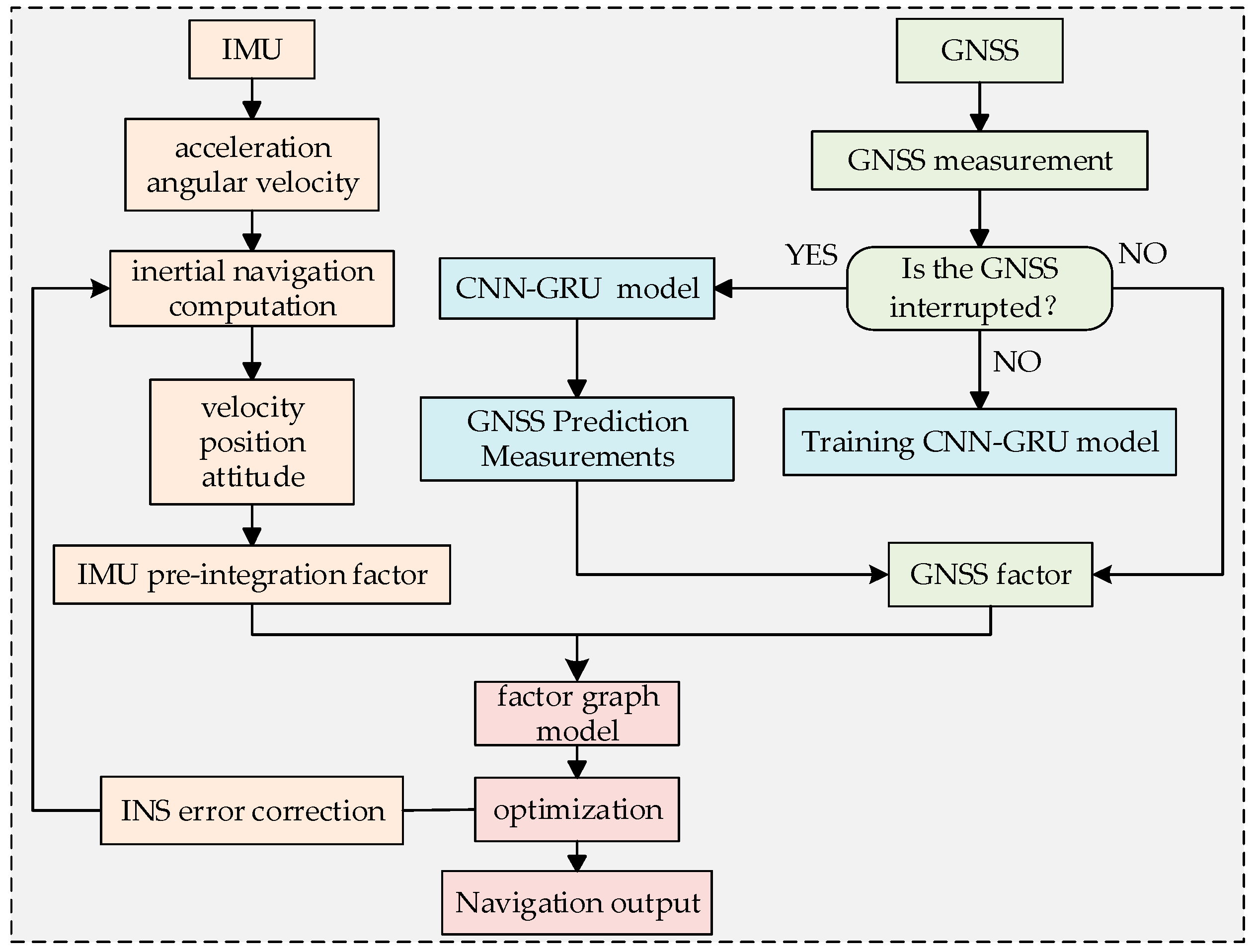
2. Integrated System Solution
3. Factor Graph Integrated Navigation Framework
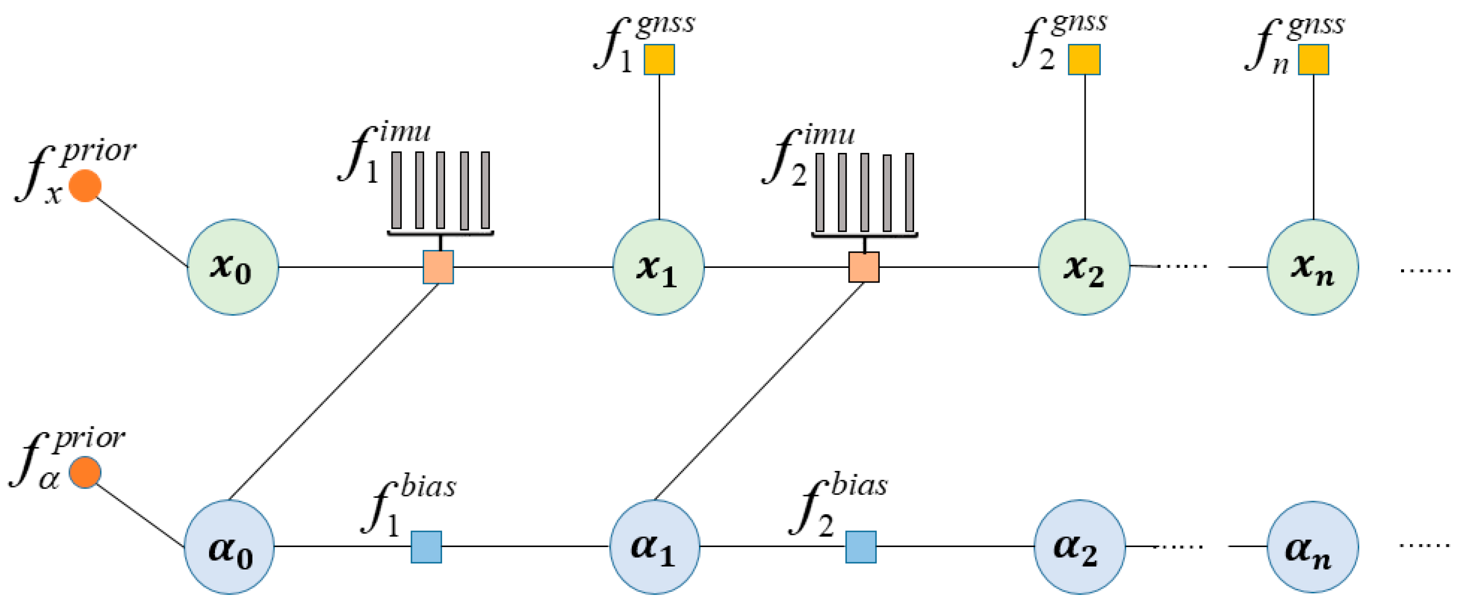
3.1. Factor Graph Information Fusion Theory
3.2. IMU Pre-Integration Factor Node
3.3. GNSS Factor Nodes
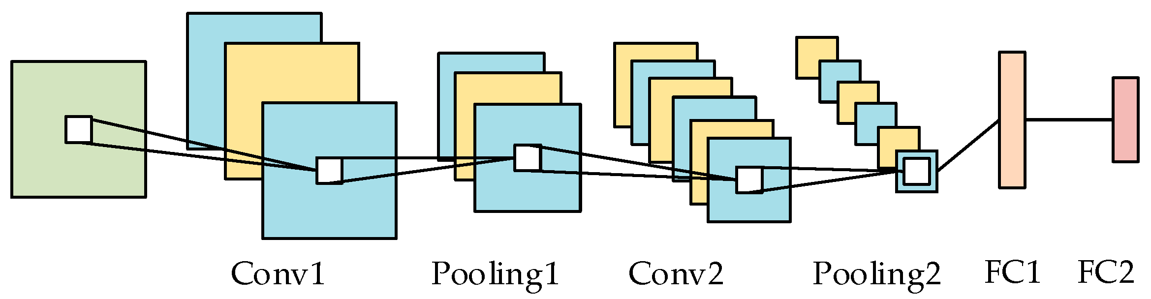
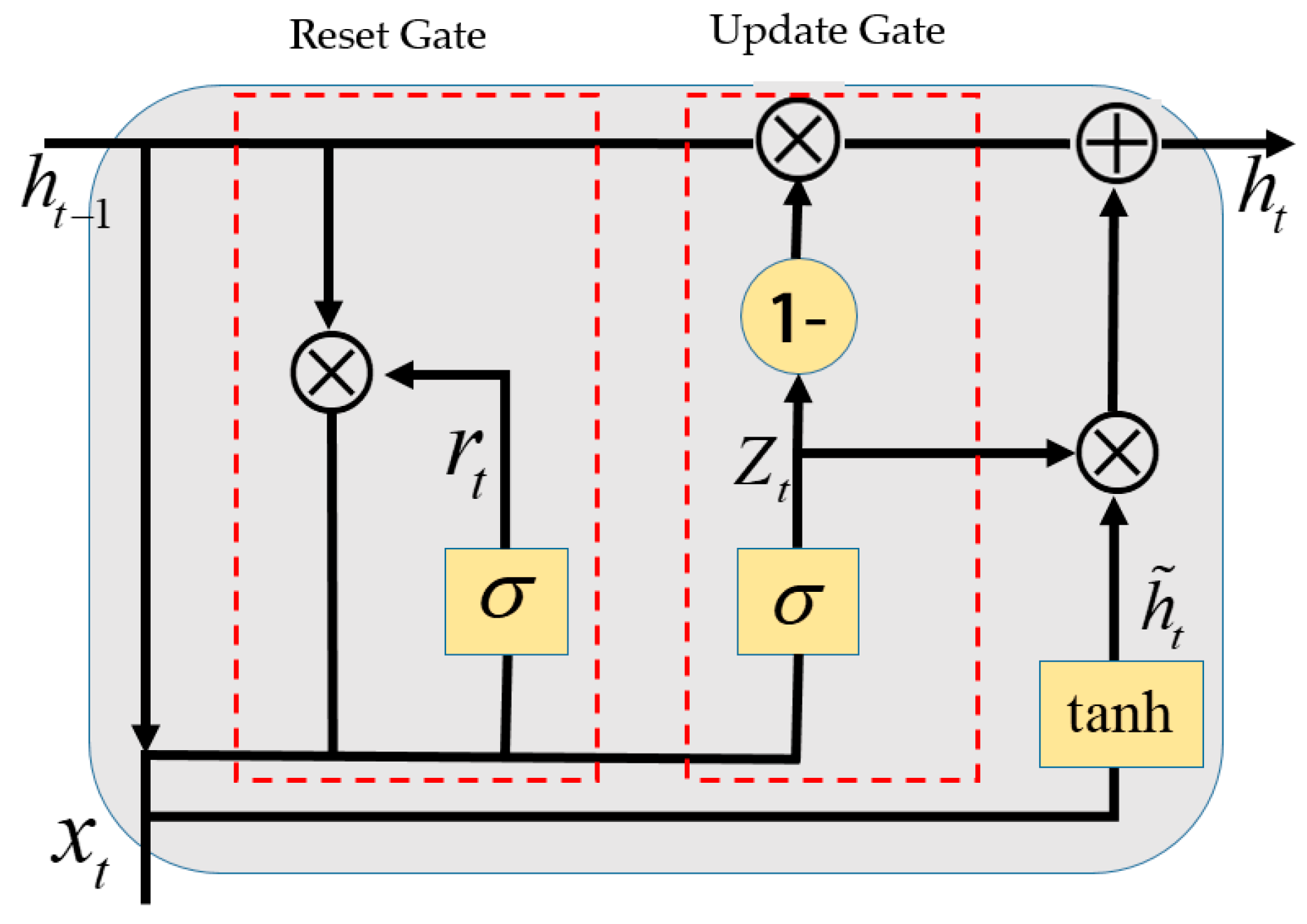
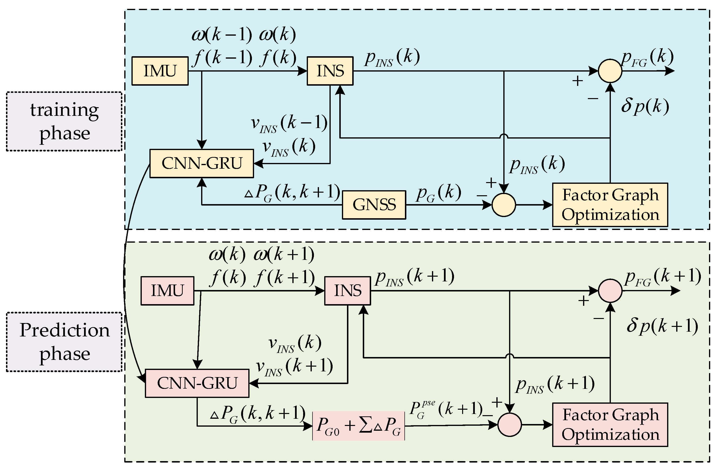
4. CNN-GRU Neural Network Prediction-Assisted Positioning Method
4.1. CNN-GRU Model
4.2. CNN-GRU-Based GNSS Outage Assisted Prediction
5. Experiment
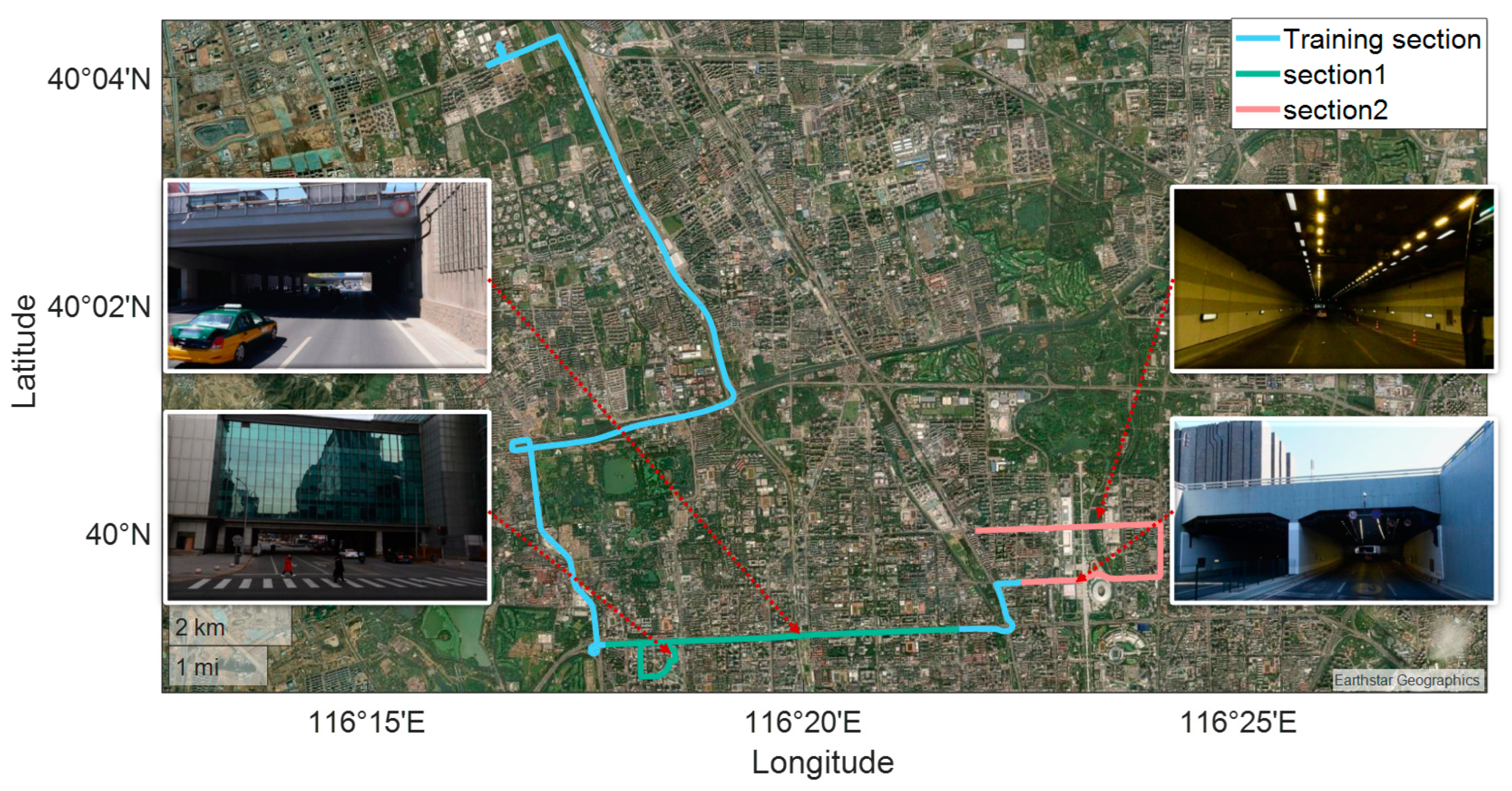
5.1. Experimental Setup and Data Acquisition
- (1)
- FGO: factor graph-based integrated navigation method;
- (2)
- LSTM-FGO: factor graph-based integrated navigation method assisted by a long short-term memory (LSTM) network;
- (3)
- CNN-GRU-FGO: The proposed integrated navigation method, combining convolutional neural network (CNN) and gated recurrent unit (GRU) with factor graph assistance.
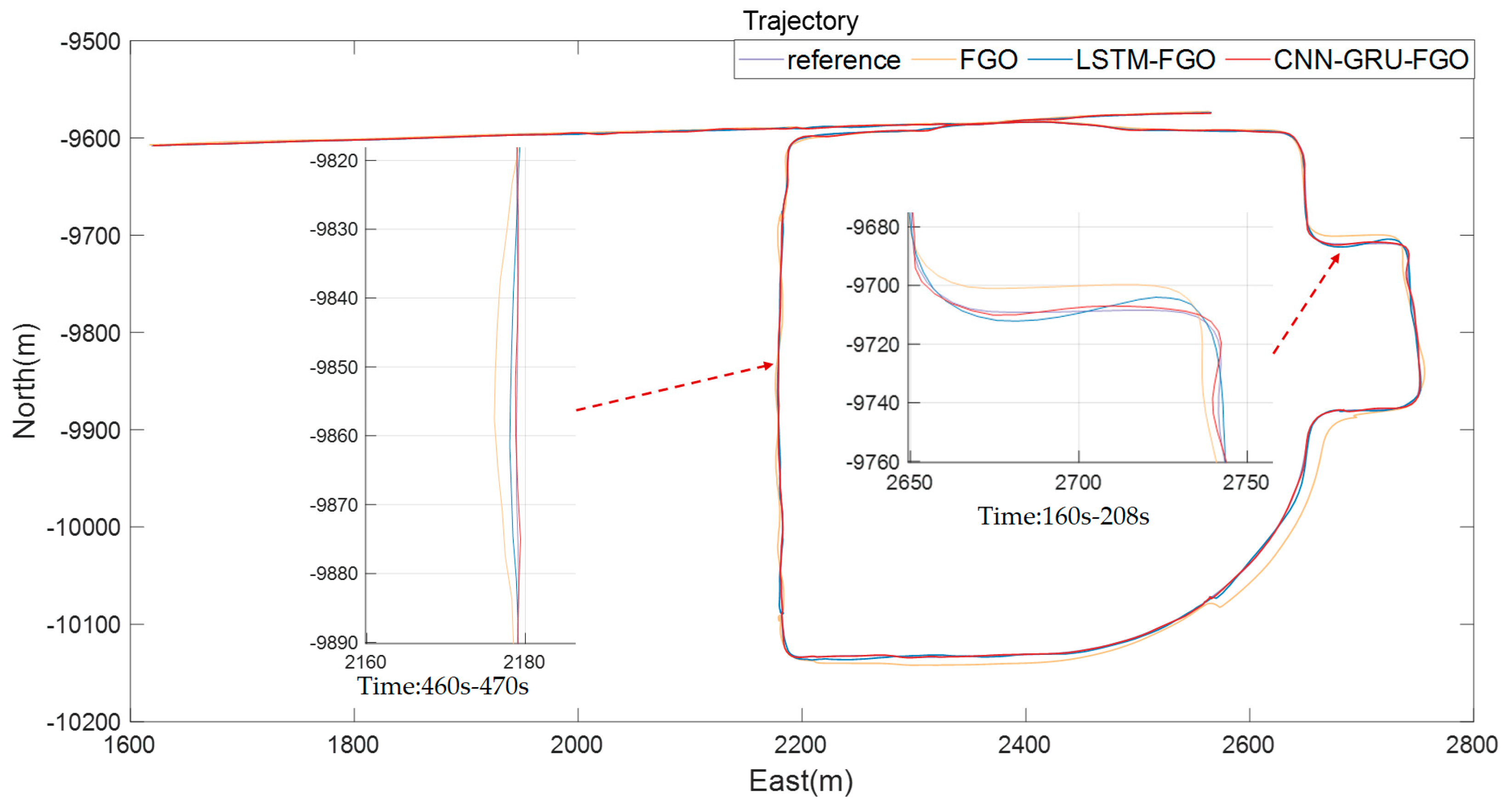
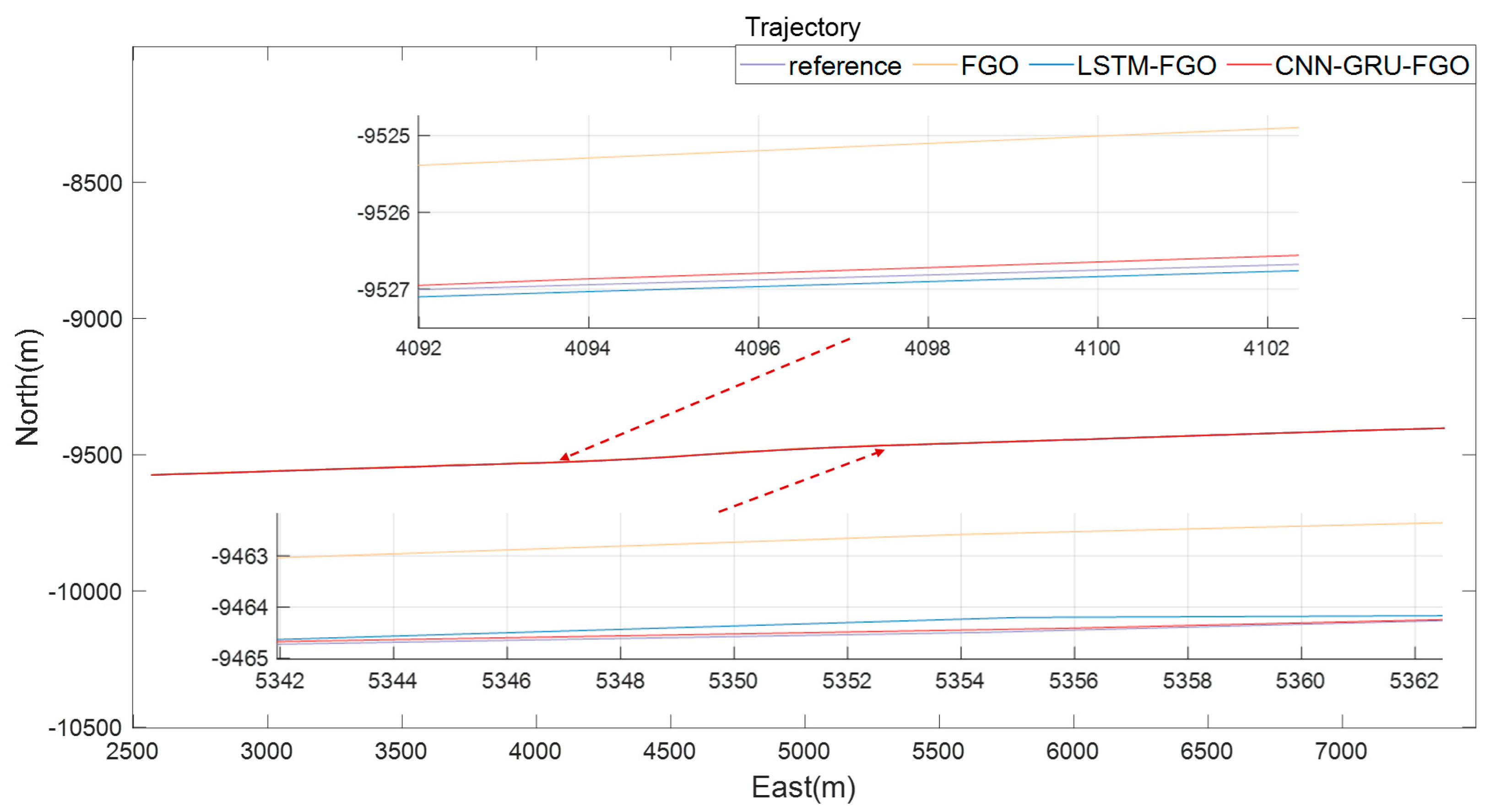
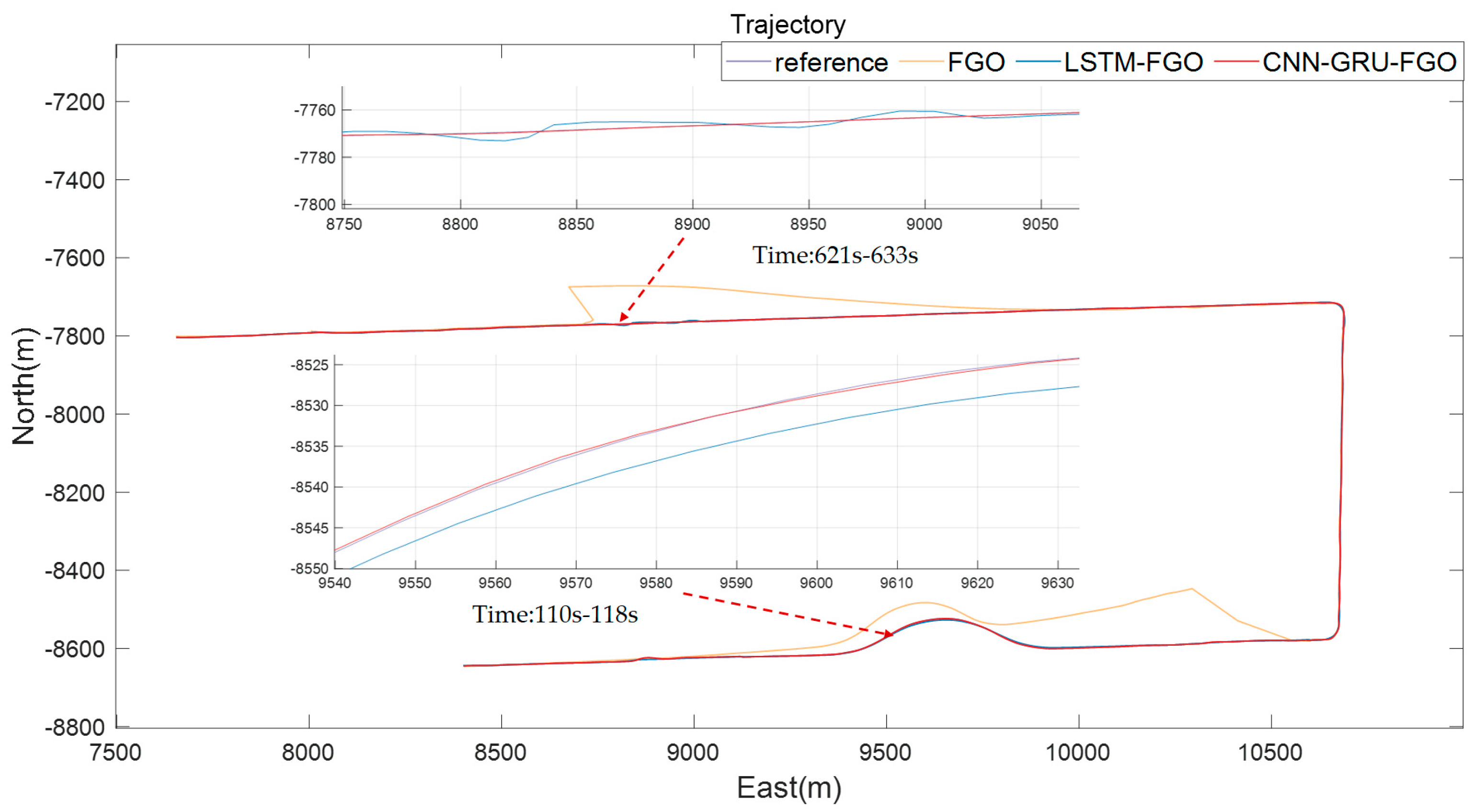
5.2. Experimental Verification and Analysis
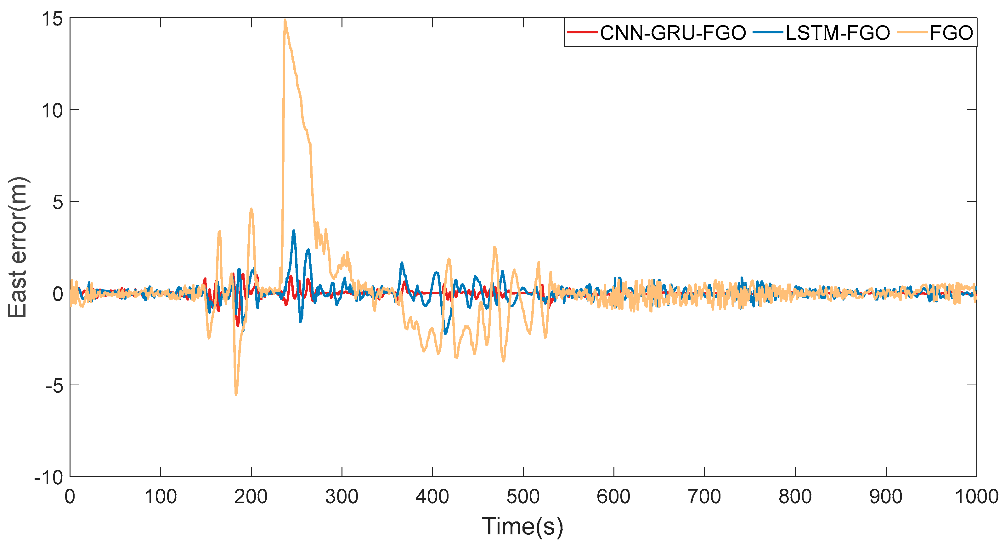
5.2.1. Frequent Interruption Test
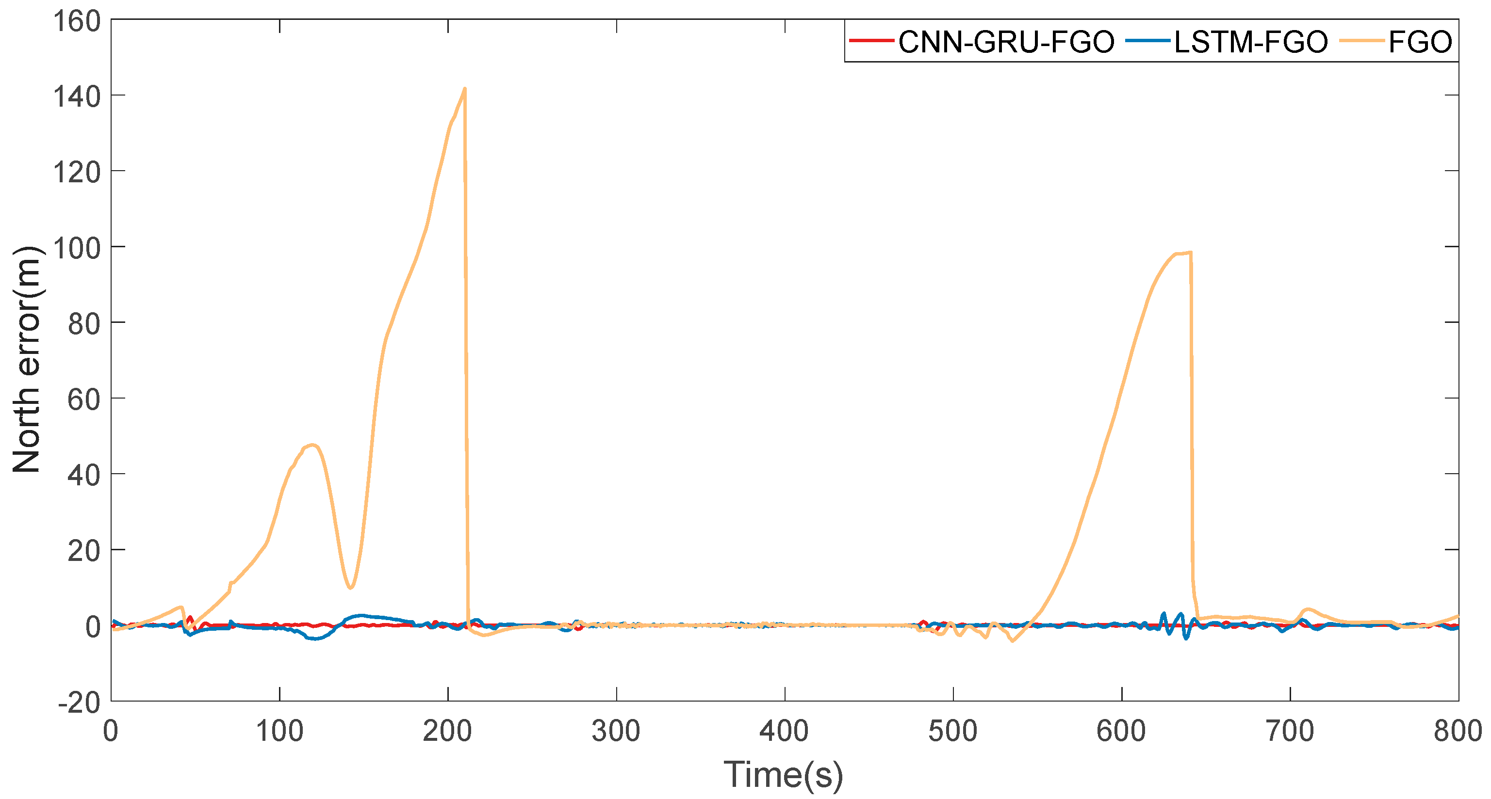
5.2.2. Continuous Interruption Test
6. Conclusions
Author Contributions
Funding
Institutional Review Board Statement
Informed Consent Statement
Data Availability Statement
Conflicts of Interest
References
- Boguspayev, N.; Akhmedov, D.; Raskaliyev, A.; Kim, A.; Sukhenko, A. A comprehensive review of GNSS/INS integration techniques for land and air vehicle applications. Appl. Sci. 2023, 13, 4819. [Google Scholar] [CrossRef]
- He, Y.; Li, J.; Liu, J. Research on GNSS INS & GNSS/INS integrated navigation method for autonomous vehicles: A survey. IEEE Access 2023, 11, 79033–79055. [Google Scholar]
- Hein, G.W. Status, perspectives and trends of satellite navigation. Satell. Navig. 2020, 1, 22. [Google Scholar] [CrossRef] [PubMed]
- Wu, F.; Luo, H.; Jia, H.; Zhao, F.; Xiao, Y.; Gao, X. Predicting the noise covariance with a multitask learning model for Kalman filter-based GNSS/INS integrated navigation. IEEE Trans. Instrum. Meas. 2020, 70, 1–13. [Google Scholar] [CrossRef]
- Abdelaziz, N.; El-Rabbany, A. An integrated ins/lidar slam navigation system for gnss-challenging environments. Sensors 2022, 22, 4327. [Google Scholar] [CrossRef]
- Guo, H.; Liu, H.; Zhou, Y.; Hu, X. Robust state estimation via maximum correntropy ekf on matrix lie groups with application to low-cost ins/gps integrated navigation system. IEEE Sens. J. 2023, 23, 9467–9479. [Google Scholar] [CrossRef]
- Hu, G.; Xu, L.; Gao, B.; Chang, L.; Zhong, Y. Robust unscented Kalman filter-based decentralized multisensor information fusion for INS/GNSS/CNS integration in hypersonic vehicle navigation. IEEE Trans. Instrum. Meas. 2023, 72, 8504011. [Google Scholar] [CrossRef]
- Gao, B.; Hu, G.; Gao, S.; Zhong, Y.; Gu, C. Multi-sensor optimal data fusion for INS/GNSS/CNS integration based on unscented Kalman filter. Int. J. Control. Autom. Syst. 2018, 16, 129–140. [Google Scholar] [CrossRef]
- Wu, X.; Xiao, B.; Wu, C.; Guo, Y.; Li, L. Factor graph based navigation and positioning for control system design: A review. Chin. J. Aeronaut. 2022, 35, 25–39. [Google Scholar] [CrossRef]
- Taylor, C.; Gross, J. Factor Graphs for Navigation Applications: A Tutorial. NAVIGATION J. Inst. Navig. 2024, 71, navi.653. [Google Scholar] [CrossRef]
- Wen, W.; Bai, X.; Kan, Y.C.; Hsu, L.-T. Tightly coupled GNSS/INS integration via factor graph and aided by fish-eye camera. IEEE Trans. Veh. Technol. 2019, 68, 10651–10662. [Google Scholar] [CrossRef]
- Jiang, C.; Chen, Y.; Chen, C.; Jia, J.; Sun, H.; Wang, T.; Hyyppa, J. Smartphone PDR/GNSS integration via factor graph optimization for pedestrian navigation. IEEE Trans. Instrum. Meas. 2022, 71, 8504112. [Google Scholar] [CrossRef]
- Song, Y.; Hsu, L.T. Tightly coupled integrated navigation system via factor graph for UAV indoor localization. Aerosp. Sci. Technol. 2021, 108, 106370. [Google Scholar] [CrossRef]
- Zhang, L.; Hsu, L.T.; Zhang, T. A novel INS/USBL integrated navigation scheme via factor graph optimization. IEEE Trans. Veh. Technol. 2022, 71, 9239–9249. [Google Scholar] [CrossRef]
- Meiling, W.; Guoqiang, F.; Huachao, Y.; Yafeng, L.; Yi, Y.; Xuan, X. A loosely coupled MEMS-SINS/GNSS integrated system for land vehicle navigation in urban areas. In Proceedings of the 2017 IEEE International Conference on Vehicular Electronics and Safety (ICVES), Vienna, Austria, 27–28 June 2017; pp. 103–108. [Google Scholar]
- Çifdalöz, O. Navigation Under GNSS Denied Environments: Zero Velocity and Zero Turning Update. Avrupa Bilim Teknol. Derg. 2022, 38, 360–369. [Google Scholar] [CrossRef]
- Cheng, S.; Cheng, J.; Zang, N.; Cai, J.; Fan, S.; Zhang, Z.; Song, H. Adaptive non-holonomic constraint aiding Multi-GNSS PPP/INS tightly coupled navigation in the urban environment. GPS Solut. 2023, 27, 152. [Google Scholar] [CrossRef]
- Wang, D.; Dong, Y.; Li, Z.; Li, Q.; Wu, J. Constrained MEMS-based GNSS/INS tightly coupled system with robust Kalman filter for accurate land vehicular navigation. IEEE Trans. Instrum. Meas. 2019, 69, 5138–5148. [Google Scholar] [CrossRef]
- Al Bitar, N.; Gavrilov, A.; Khalaf, W. Artificial intelligence based methods for accuracy improvement of integrated navigation systems during GNSS signal outages: An analytical overview. Gyroscopy Navig. 2020, 11, 41–58. [Google Scholar] [CrossRef]
- Jwo, D.J.; Biswal, A.; Mir, I.A. Artificial neural networks for navigation systems: A review of recent research. Appl. Sci. 2023, 13, 4475. [Google Scholar] [CrossRef]
- Siemuri, A.; Selvan, K.; Kuusniemi, H.; Valisuo, P.; Elmusrati, M.S. A systematic review of machine learning techniques for GNSS use cases. IEEE Trans. Aerosp. Electron. Syst. 2022, 58, 5043–5077. [Google Scholar] [CrossRef]
- Yao, Y.; Xu, X.; Zhu, C.; Chan, C.-Y. A hybrid fusion algorithm for GPS/INS integration during GPS outages. Measurement 2017, 103, 42–51. [Google Scholar] [CrossRef]
- Dai, H.-F.; Bian, H.-W.; Wang, R.-Y.; Ma, H. An INS/GNSS integrated navigation in GNSS denied environment using recurrent neural network. Def. Technol. 2020, 16, 334–340. [Google Scholar] [CrossRef]
- Zhang, Y. A fusion methodology to bridge GPS outages for INS/GPS integrated navigation system. IEEE Access 2019, 7, 61296–61306. [Google Scholar] [CrossRef]
- Fang, W.; Jiang, J.; Lu, S.; Gong, Y.; Tao, Y.; Tang, Y.; Yan, P.; Luo, H.; Liu, J. A LSTM algorithm estimating pseudo measurements for aiding INS during GNSS signal outages. Remote Sens. 2020, 12, 256. [Google Scholar] [CrossRef]
- Tang, Y.; Jiang, J.; Liu, J.; Yan, P.; Tao, Y.; Liu, J. A GRU and AKF-based hybrid algorithm for improving INS/GNSS navigation accuracy during GNSS outage. Remote Sens. 2022, 14, 752. [Google Scholar] [CrossRef]
- Wei, X.; Li, J.; Zhang, D.; Feng, K. An improved integrated navigation method with enhanced robustness based on factor graph. Mech. Syst. Signal Process. 2021, 155, 107565. [Google Scholar] [CrossRef]
- Bai, S.; Lai, J.; Lyu, P.; Wang, B.; Sun, X.; Yu, W. An Enhanced Adaptable Factor Graph for Simultaneous Localization and Calibration in GNSS/IMU/Odometer Integration. IEEE Trans. Veh. Technol. 2023, 72, 11346–11357. [Google Scholar] [CrossRef]
- Qin, H.; Wang, X.; Wang, G.; Hu, M.; Bian, Y.; Qin, X.; Ding, R. A novel INS/USBL/DVL integrated navigation scheme against complex underwater environment. Ocean. Eng. 2023, 286, 115485. [Google Scholar] [CrossRef]
- Tang, H.; Zhang, T.; Niu, X.; Fan, J.; Liu, J. Impact of the earth rotation compensation on MEMS-IMU preintegration of factor graph optimization. IEEE Sens. J. 2022, 22, 17194–17204. [Google Scholar] [CrossRef]
- Li, Q.; Zhang, L.; Wang, X. Loosely coupled GNSS/INS integration based on factor graph and aided by ARIMA model. IEEE Sens. J. 2021, 21, 24379–24387. [Google Scholar] [CrossRef]
- Zou, X.; Lian, B.; Wu, P. Fault identification ability of a robust deeply integrated GNSS/INS system assisted by convolutional neural networks. Sensors 2019, 19, 2734. [Google Scholar] [CrossRef] [PubMed]
- Li, D.; Wu, Y.; Zhao, J. Novel hybrid algorithm of improved CKF and GRU for GPS/INS. IEEE Access 2020, 8, 202836–202847. [Google Scholar] [CrossRef]
- Meng, X.; Tan, H.; Yan, P.; Zheng, Q.; Chen, G.; Jiang, J. A GNSS/INS integrated navigation compensation method based on CNN-GRU+ IRAKF hybrid model during GNSS outages. IEEE Trans. Instrum. Meas. 2024, 73, 2510015. [Google Scholar] [CrossRef]
- Al Bitar, N.; Gavrilov, A. A new method for compensating the errors of integrated navigation systems using artificial neural networks. Measurement 2021, 168, 108391. [Google Scholar] [CrossRef]


| Sensor | Parameters | Accuracy |
|---|---|---|
| IMU | Gyroscope Bias | 20°/h |
| GNSS | Gyroscope Random Walk | |
| Accelerometer Bias | 50 mg | |
| Sampling Frequency | 100 Hz | |
| Position Accuracy | 2 m | |
| Sampling Frequency | 1 Hz |
| Start Time (s) | Interruption Duration (s) | Start Time (s) | Interruption Duration (s) | Start Time (s) | Interruption Duration (s) |
|---|---|---|---|---|---|
| 70 | 4 | 450 | 2 | 616 | 6 |
| 96 | 2 | 465 | 5 | 650 | 6 |
| 156 | 8 | 471 | 3 | 662 | 8 |
| 168 | 14 | 474 | 4 | 686 | 12 |
| 183 | 25 | 482 | 10 | 717 | 6 |
| 241 | 25 | 511 | 7 | 730 | 5 |
| 320 | 6 | 543 | 5 | 775 | 7 |
| 366 | 2 | 597 | 11 | ||
| 413 | 9 | 608 | 7 |
| Section 1 | Algorithm | Orientation | RMSE (m) | Maximum Error (m) |
|---|---|---|---|---|
| winding road | FGO | east | 3.06 | 14.91 |
| north | 3.54 | 13.19 | ||
| LSTM-FGO | east | 0.62 | 3.41 | |
| north | 0.90 | 4.48 | ||
| CNN-GRU-FGO | east | 0.27 | 1.81 | |
| north | 0.40 | 1.92 | ||
| long straight road | FGO | east | 0.38 | 0.99 |
| north | 1.35 | 3.67 | ||
| LSTM-FGO | east | 0.26 | 0.85 | |
| north | 0.19 | 0.80 | ||
| CNN-GRU-FGO | east | 0.05 | 0.19 | |
| north | 0.12 | 0.56 | ||
| all road | FGO | east | 2.34 | 14.91 |
| north | 2.84 | 13.19 | ||
| LSTM-FGO | east | 0.50 | 3.41 | |
| north | 0.70 | 4.48 | ||
| CNN-GRU-FGO | east | 0.21 | 1.81 | |
| north | 0.31 | 1.92 |
| Start Time (s) | Interruption Duration (s) | Start Time (s) | Interruption Duration (s) | Start Time (s) | Interruption Duration (s) |
|---|---|---|---|---|---|
| 44 | 144 | 432 | 6 | 789 | 4 |
| 285 | 4 | 469 | 5 | ||
| 310 | 8 | 534 | 108 |
| Section 2 | Algorithm | Orientation | RMSE (m) | Maximum Error (m) |
|---|---|---|---|---|
| winding road | FGO | east | 5.73 | 25.42 |
| north | 41.48 | 141.69 | ||
| LSTM-FGO | east | 0.48 | 1.66 | |
| north | 1.08 | 3.62 | ||
| CNN-GRU-FGO | east | 0.19 | 1.49 | |
| north | 0.28 | 2.18 | ||
| long straight road | FGO | east | 1.33 | 3.81 |
| north | 30.79 | 98.44 | ||
| LSTM-FGO | east | 0.41 | 2.58 | |
| north | 0.62 | 3.54 | ||
| CNN-GRU-FGO | east | 0.13 | 1.08 | |
| north | 0.24 | 1.60 | ||
| all road | FGO | east | 4.16 | 25.42 |
| north | 36.55 | 141.69 | ||
| LSTM-FGO | east | 0.45 | 2.58 | |
| north | 0.88 | 3.62 | ||
| CNN-GRU-FGO | east | 0.16 | 1.49 | |
| north | 0.26 | 2.18 |
Disclaimer/Publisher’s Note: The statements, opinions and data contained in all publications are solely those of the individual author(s) and contributor(s) and not of MDPI and/or the editor(s). MDPI and/or the editor(s) disclaim responsibility for any injury to people or property resulting from any ideas, methods, instructions or products referred to in the content. |
© 2024 by the authors. Licensee MDPI, Basel, Switzerland. This article is an open access article distributed under the terms and conditions of the Creative Commons Attribution (CC BY) license (https://creativecommons.org/licenses/by/4.0/).
Share and Cite
Zhao, H.; Liu, F.; Chen, W. A Method for Assisting GNSS/INS Integrated Navigation System during GNSS Outage Based on CNN-GRU and Factor Graph. Appl. Sci. 2024, 14, 8131. https://doi.org/10.3390/app14188131
Zhao H, Liu F, Chen W. A Method for Assisting GNSS/INS Integrated Navigation System during GNSS Outage Based on CNN-GRU and Factor Graph. Applied Sciences. 2024; 14(18):8131. https://doi.org/10.3390/app14188131
Chicago/Turabian StyleZhao, Hailin, Fuchao Liu, and Wenjue Chen. 2024. "A Method for Assisting GNSS/INS Integrated Navigation System during GNSS Outage Based on CNN-GRU and Factor Graph" Applied Sciences 14, no. 18: 8131. https://doi.org/10.3390/app14188131
APA StyleZhao, H., Liu, F., & Chen, W. (2024). A Method for Assisting GNSS/INS Integrated Navigation System during GNSS Outage Based on CNN-GRU and Factor Graph. Applied Sciences, 14(18), 8131. https://doi.org/10.3390/app14188131