Abstract
The objective of this study is to elucidate the principal determinants influencing the thermal comfort of campus sidewalks, and to discern the nexus between sidewalk planting configurations and thermal comfort. Initially, thermal environment simulations are conducted across various temporal intervals, predicated upon the extant sidewalk planting configuration. Subsequently, an analysis is undertaken to delineate the causative factors contributing to suboptimal thermal comfort within the prevailing milieu. Finally, an evaluation of configurations conducive to enhancing campus thermal comfort through divergent planting design solutions is undertaken, thereby engendering discourse on sidewalk planting design. The findings show that impermeable pavement, encompassing sidewalks and driveways, emerges as the pre-eminent precipitant of diminished thermal comfort within the study locale. The implementation of a double-row staggered tree-planting approach, coupled with multi-layered shrub planting, emerges as the optimal solution for augmenting thermal comfort. Consequently, the outcomes of this study proffer discernibly superior alternatives for ameliorating the heat island effect and fostering the establishment of a sustainable campus paradigm.
1. Introduction
The rapid urbanization and population growth have led to an escalation in human activities within cities, intensifying their impact on the global climate [1]. This phenomenon has resulted in a gradual increase in average surface temperatures, rising sea levels, and the proliferation of extreme weather events. Consequently, these issues have garnered significant attention and concern worldwide. According to the annual global climate report released by the World Meteorological Organization, the period spanning from 2015 to 2021 ranked as the seven warmest years on record since data collection began in 1850 [2]. Furthermore, predictions indicate that global temperatures will continue to rise over the five-year period from 2022 to 2026. The annual average global surface temperature is projected to surpass pre-industrial levels, with an increase ranging from 1.1 to 1.7 °C. Being an island nation, Taiwan is susceptible to the influence of warm, humid air masses and ocean currents, resulting in a hot and rainy climate. Particularly during the summer months, temperatures consistently break new records each year. According to the Global and Taiwan Temperature Trend Analysis Report released by the Central Weather Bureau, data from the past three decades (1991–2020) indicate a temperature trend of a 0.30 °C increase every decade across 13 flat weather stations, surpassing the global average of 0.21 °C per decade. Hence, addressing the ongoing rise in temperatures necessitates attention, alongside the implementation of corresponding measures to mitigate the challenges posed by urban heat islands and alleviate the myriad adverse effects associated with poor thermal comfort on our daily lives [3,4].
Over the past decade, the issue of the heat island effect has garnered considerable public attention. The proliferation of cement buildings, the diminishing presence of open spaces and green areas, and the prevalence of poorly ventilated designs have become increasingly commonplace. These trends have exacerbated the severity of the urban heat island effect, thereby adversely impacting the microclimate of urban areas [5]. Tunghai University’s campus has traditionally served as a mitigating factor for the urban thermal environment within the city. However, with evolving societal needs and increased usage demands, factors such as burgeoning campus infrastructure, diminishing forested areas, expanding impermeable surfaces, and heightened energy consumption have contributed to an artificial increase in heat within the campus environment, consequently affecting its microclimate.
The adverse thermal conditions have profound implications for the physical and mental well-being of students. Additionally, the university’s second campus, once a pasture with sparse tree coverage and primarily grassland, lacks adequate shading. Past studies have highlighted that urban vegetation primarily provides cooling through shading, followed by evapotranspiration [6]. The scarcity of trees leaves the second campus less shaded, thus resulting in inferior thermal comfort compared to the first campus. Moreover, with plans for the establishment of a Taichung MRT station in close proximity to Tunghai University, considerations for the campus’s future development have prompted the redesign of roads on the second campus. The objective is to foster a pedestrian-friendly environment. Notably, the sidewalk along the south side of the Department of Music and Arts Building, situated adjacent to the newly planned east–west main thoroughfare named Tunghai Avenue, currently lacks adequate tree coverage. This renders pedestrians vulnerable to prolonged sun exposure throughout the day, leading to thermal discomfort [7,8].
The objectives of this study are to investigate the impact of various planting configurations on the urban thermal environment and their role in enhancing thermal comfort. To achieve this goal, we conducted thermal environment simulations at different times along the sidewalk on the south side of the Department of Music and Arts Building. The objective is to elucidate the underlying causes of poor thermal comfort in the current setting and propose solutions to ameliorate the existing thermal conditions through the strategic placement of trees and the implementation of multi-layer planting designs. By optimizing plant configurations, we aim to enhance thermal comfort levels. Ultimately, the findings of this research can serve as a valuable reference for future sustainable campus planning endeavors. By providing insights into effective strategies for improving the campus thermal environment, this study empowers campus planners to enhance overall campus environmental quality [9].
2. Related Works
The campus environment serves not only as a space for students to acquire knowledge but also as an area for relaxation and leisure for all individuals. A subpar thermal environment within the campus can detrimentally affect the physical and mental well-being, as well as the learning efficiency, of its occupants. Moreover, it can diminish the public’s inclination to utilize outdoor spaces. Hence, the imperative to enhance campus thermal comfort is increasingly paramount. As such, the literature primarily referenced in this study encompasses topics such as urban microclimate, thermal comfort indicators, and the influence of planting design on thermal comfort.
2.1. Urban Microclimate
The term “climate” finds its roots in the ancient Greek word “Klima”, originally denoting a tendency or trend, which is pertinent to understanding how historical perspectives have shaped our modern concept of climate. As per the World Meteorological Organization’s definition, climate encompasses the average meteorological conditions and their evolving patterns within a specific geographic area over an extended period. This includes parameters such as wind speed, cloud cover, temperature, precipitation, air pressure, and other meteorological elements [10]. Drawing upon Guo’s reference to Professor Yoshino Masatoshi’s work on “microclimate”, the climate spectrum can be categorized into macroclimate, meso-climate, small climate, and microclimate, each delineated by its specific scope. Expanding on the concept of microclimate as elucidated by Oke [11] in Boundary Layer Climates, urban climate emerges as a localized climatic phenomenon shaped by the influence of urbanization and human activities within the broader regional climate context. Surface materials, solar radiation, and air pollution stand as primary factors influencing urban climate dynamics.
The urban canopy’s significant variability results in the formation of multiple microclimates with distinct characteristics within the urban environment, as illustrated in Figure 1. As defined by the Construction Administration of the Ministry of the Interior, “microclimate” pertains to climatic conditions influenced by various urban surface structures, including soil composition, vegetation density, slope, orientation, and openness, among other factors. The influence of microclimate extends vertically from the ground surface to the height of buildings, vegetation, and other objects. Once it reaches the level of vegetation, buildings, or micro-topography, their effects become negligible at approximately four times their height, typically within a range of 12 m above and below the surface and beneath the plant canopy [12,13].
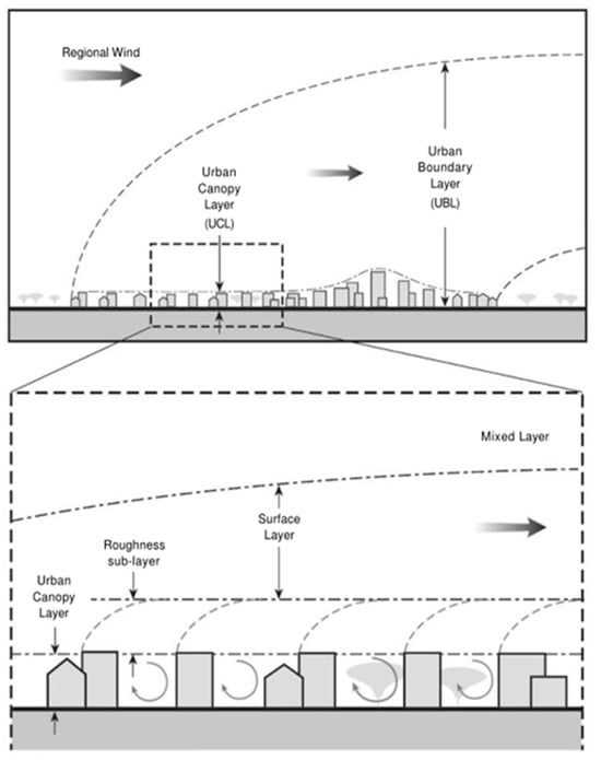
Figure 1.
Schematic diagram of urban atmosphere.
2.2. Thermal Comfort Indicators
Different countries and regions employ various thermal comfort indicators to assess outdoor thermal comfort, such as physiological equivalent temperature (PET), standard effective temperature (SET), and predicted mean vote (PMV) [14]. Among these, physiological equivalent temperature has gained widespread usage in outdoor thermal assessment and has even been adopted as a thermal comfort indicator for urban planners and designers in certain countries. In 1999, the German Peter Höppe team modified Fanger’s indoor thermal comfort indicators PMV and PPD and introduced the physiological equivalent temperature (PET). This metric is based on the Munich Energy Balance Model (MEMI) and serves as a thermal environment evaluation index, akin to the Gagge two-node model. PET primarily simulates the physiological response of the human body under varying thermal conditions, considering factors such as somatosensory temperature, skin temperature, and the thermal balance state of the complex outdoor environment [15,16]. Outdoor ambient temperature is translated into the perceived indoor temperature to express comfort levels, encompassing various climatic parameters (air temperature, relative humidity, average radiation temperature, and wind speed) and physiological parameters (gender, age, weight, height, clothing, and metabolic rate) [17].
2.3. Impact of Planting Design on Thermal Comfort
The impact of planting on the thermal environment can be broadly categorized into shading phenomena and the evapotranspiration effect. Previous research has indicated that trees play a crucial role in mitigating heat by intercepting sunlight and reflecting a significant portion, typically ranging from 10% to 25%, of solar radiation. As a result, tree shade and vegetative cover contribute to lowering air temperatures. Furthermore, trees facilitate transpiration through the stomata of their leaves, a process that consumes latent heat energy and effectively reduces surface temperatures, thereby inducing a cooling effect. Some researchers have noted that a single tree can transpire an average of 100 gallons of water per day through evapotranspiration. The heat energy absorbed by plants during evapotranspiration can be substantial, with its cooling potential likened to that of five standard window air conditioners running for 20 h [18].
The strategic incorporation of plants and trees has long been recognized as a method to mitigate urban heat islands within many urban designs. Recent studies have delved into the nuanced effects of various tree configurations on the microclimate [19,20]. In a study conducted by Zhang, Zhan, and Lan [21], the findings suggested that denser tree planting can lead to more effective regulation of summer climates. Researchers further investigated how the size and density of tree canopies influence shading and cooling, with potential cooling effects reaching up to 4 °C. Prior research has also explored the impacts of impervious pavements, permeable pavements, and ponds on residential area comfort. Through this literature review, it becomes evident that different types of planting yield varied effects on urban cooling. Moreover, the benefits of enhancing thermal comfort via diverse planting configurations vary as well [22,23].
3. Methodology
This study aims to investigate the influence of planting design on the thermal environment and thermal comfort within a campus setting, emphasizing its universal relevance to various urban and landscaped areas. With the advancement of modern science and technology, microclimate analysis methods have evolved. One such method is numerical simulation, which involves transforming complex real-life scenarios into simplified mathematical models, conducting numerical computations, and deriving solutions to gain insights and make predictions. This approach is widely employed in microclimate research [24].
In recent years, there has been a proliferation of commercial general-purpose software derived from Computational Fluid Dynamics (CFD). For instance, Ibrahim highlighted ENVI-met v.5.2 as a tool capable of intricately elucidating the interaction between vegetation and microclimate, making it particularly suitable for this study [25]. ENVI-met is a 3D CFD model that comprehensively considers the interaction among surfaces, vegetation, and air. Current research predominantly utilizes such software for simulating design improvements, predicting outcomes, or conducting before-and-after comparisons. Examples include analyzing outdoor wind environments in residential areas, studying the urban heat island effect, examining indoor natural ventilation, assessing air flow conditions, and monitoring temperature fluctuations within specific spatial domains [26].
In this study, ENVI-met version 5.1.1 was utilized, incorporating features such as the space model (Spaces), material editing library (Manage Projects and Work), climate editor (ENVI-guide), core simulator (ENVI-core), biological simulator (BIO-met, New Taipei City, Taiwan), and result display (Leonardo, Milan, Italy). These components facilitate tasks such as constructing environmental models, setting model parameters, conducting calculations, and visualizing results. The file names reflect data pertaining to temperature, air speed, humidity, and radiation within the defined spatial area. Furthermore, this study employed Biomet within ENVI-met version 5.1.1 to calculate the Physiological Equivalent Temperature (PET) as a thermal comfort index. Biomet serves as a post-processing tool specifically designed for assessing human thermal comfort. The calculation process entails importing a valid ENVI-met simulation output file into Biomet, along with inputting relevant background parameters associated with the simulated human body [27].
3.1. Atmospheric Model Setting
The atmospheric model primarily simulates the interplay among wind speed, temperature, humidity, atmospheric turbulence, and long-short wave radiation. Parameters adjustable within the model encompass wind speed, wind direction, surface roughness, initial temperature, relative humidity, and absolute temperature at a 10 m height. For the simulation, environmental parameters are derived from climate data corresponding to July, the warmest month, in Xitun District, Taichung City. Specifically, data from the four hottest days in July 2022—July 22nd, July 23rd, and July 24th—are utilized. Average values of temperature, humidity, wind direction, and wind speed from July 25th serve as input parameters. The simulation is conducted at 13:00, a peak hot time conducive to outdoor activities, particularly during breaks on the Tunghai University campus, as shown in Figure 2.
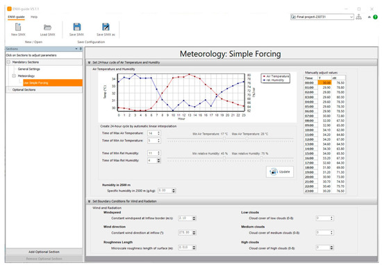
Figure 2.
Interface of atmospheric model setting.
3.2. Surface Soil Model Setting
The surface soil sub-model operates as a one-dimensional model, focusing on pavement parameters such as albedo, emissivity, and water retention, with flexibility for inputting various parameters. Among these parameters, albedo stands out as a critical influencer. It is categorized based on the type of campus pavement, which includes asphalt roads, soil, bricks, and concrete, as shown in Figure 3. Albedo settings are determined by referencing urban surface properties compiled by researchers.
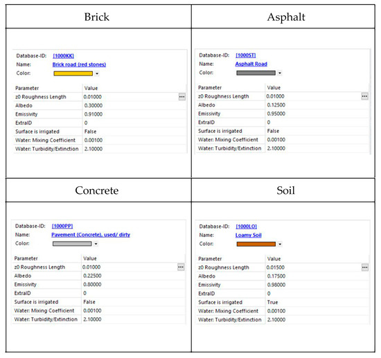
Figure 3.
Interface of surface soil model setting.
3.3. Plant Model Setting
The plant sub-model primarily simulates the heat exchange process between plants and their surrounding environment. Within ENVI-met, plants are simplified into a one-dimensional model, which is further divided into two components: growth height and root depth. Input parameters encompass CO2 fixation type, leaf type, albedo, planting height, root depth, Leaf Area Density (LAD) representing leaf density, and Root Area Density (RAD) indicating the number and distribution of plant roots at various heights or depths. For campus vegetation, the principal street trees within the study area are Taiwanese camphor trees. These are represented in the 3D planting setting as circular tree species, as shown in Figure 4.
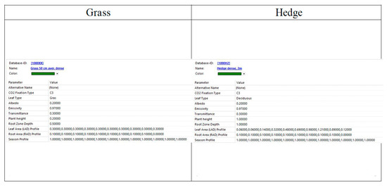
Figure 4.
Interface of plant model setting.
4. Results
Tunghai University partnered with AECOM Engineering Consulting Co., Ltd., to spearhead comprehensive campus planning, ensuring our continued leadership, innovation, and adaptability. The transportation plan introduced two key concepts centered around enhancing the pedestrian experience and separating pedestrian and vehicular traffic. The first concept focuses on enhancing the main street while implementing a refined system for separating pedestrian and vehicle lanes. The second concept involves redefining the roles of school gates and roads. By rerouting existing roads and designating a new thoroughfare as New Tunghai Avenue, and establishing the east gate of the second campus, we aim to alleviate highway congestion and bolster east–west connectivity within the campus. This initiative’s focal point lies at the core of New Tunghai Avenue, situated south of the Department of Fine Arts and Music, as shown in Figure 5.
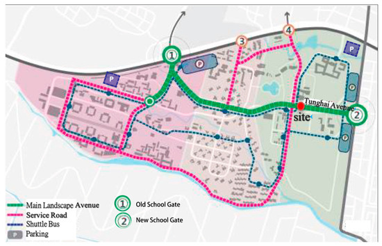
Figure 5.
Site location map.
The focus of this study’s simulation is a segment of the pedestrian walkway on Tunghai Avenue, located south of the Music Department building’s parking lot. The simulation area is 80 m long and 25 m wide. The surrounding area is open with no buildings, and the nearest architecture, the Music Department building, is approximately sixty meters away.
4.1. Thermal Simulation Verifications of the Study Area
- Surface temperature verification
Surface temperature plays a critical role in thermal environment simulations. In this study, we conducted a comparison between the simulation results of pavements made of different materials and relevant historical measured data. At 14:00, the surface temperature of grassland in the current simulation scheme ranged approximately from 31.38 to 48.12 °C, with an average of 35.27 °C. This finding aligns closely with the average surface temperature of grassland recorded by Lin at 14:00 during summer in Taiwan, which was 36 °C. Similarly, the surface temperature of concrete in the current scheme ranged from about 42.67 to 50.84 °C, averaging at 47.35 °C. This result mirrors the average concrete surface temperature of 45 °C measured by some researchers in Taiwan during the summer. In conclusion, the simulation results for surface temperature are consistent with the trends observed in the relevant literature, indicating a certain level of reliability in our simulations.
- 2.
- Air temperature verification
In the current simulation scenario, the air temperature at 13:00 ranges from 34.35 to 37.52 °C, with an average of 35.22 °C. Data from the Taichung Weather Station indicate that the air temperature at noon in July 2022 falls between 33.6 and 34.7 °C, averaging about 34.2 °C (averaging across sunny days with no rain in the preceding days). Similarly, environmental monitoring data from Tunghai University Smart Campus reveal that the air temperature at noon in July 2022 varies between 33.8 and 35.2 °C, averaging around 34.4 °C (averaging across sunny days with no rain in the preceding days). The simulated air temperature for each scheme closely aligns with the actual measured values, indicating that the simulation results provide a reliable reference point.
- 3.
- Relative humidity verification
In the current simulation settings, the relative humidity at 13:00 ranges from 52.07% to 68.59%, with an average of 62.67%. According to data from the Taichung Weather Station, the relative humidity at noon in July 2022 falls between 54% and 78%, averaging about 62% (averaging across sunny days with no rain in the preceding days). Similarly, based on environmental monitoring data from Tunghai University Smart Campus, the relative humidity at noon in July 2022 ranges from 49% to 59.3%, with an average of about 54.23% (averaging across sunny days with no rain in the preceding days). Overall, the simulated humidity for each scenario closely matches the measured values, indicating a reliable level of reference in the simulation results.
4.2. Thermal Changes in Microclimate Parameters of the Study Area
- In terms of surface temperature, the lowest temperatures within the study area are observed in the grassland on both sides of the sidewalk, with a minimum surface temperature of 32.08 °C recorded at noon. Conversely, the highest surface temperatures are predominantly found on asphalt roads, reaching up to 54.68 °C. Notably, impermeable pavements like asphalt roads and interlocking bricks exhibit higher surface temperatures compared to grassland, as shown in Figure 6.
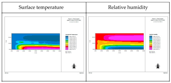 Figure 6. Current microclimate conditions of surface temperature and humidity.
 - Regarding humidity, the average relative humidity in the study area at 13:00 is approximately 62.67%. The lowest humidity within the study area is observed above the asphalt road, with levels dropping to 52.07%. Conversely, the highest humidity is primarily situated on the north side of the trees, above the grass, reaching up to 68.59%, as shown in Figure 6.
- Regarding wind speed, the average recorded at 13:00 was 1.31 m/s. The lowest wind speeds within the study area were primarily observed on the leeward side of the tree group. Conversely, the highest wind speeds were noted at the western edge of the study range, reaching up to 1.58 m/s, as shown in Figure 7.
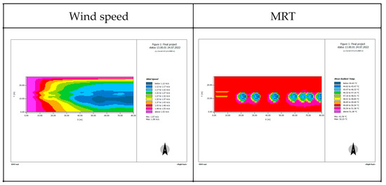 Figure 7. Current microclimate conditions of wind speed and MRT.
 - In regard to mean radiant temperature (MRT), the MRT recorded in the study area at 13:00 is 49.79 °C. The highest MRT within the overall study range is primarily observed on the asphalt pavement on the south side of the trees, with an average of 52.23 °C. Conversely, the lowest MRT is mainly found under the shade of trees, registering at 43.78 °C, as shown in Figure 7.
- Regarding thermal comfort, the current average Physiological Equivalent Temperature (PET) in the study area at 13:00 is as high as 47.09 °C, indicating a “very hot” state according to thermal sensation classifications. The highest PET area is primarily observed on the asphalt pavement, reaching a maximum PET of 49.65 °C. Conversely, the lowest PET within the overall study range is predominantly found under the shade of trees, with a minimum PET of 43.62 °C, as shown in Figure 8.
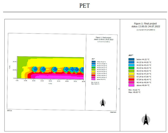 Figure 8. Current PET (*: abbreviation).
Based on the analysis of the microclimate data above, it is evident that impermeable pavement significantly contributes to the poor thermal comfort in this study area. Both asphalt and interlocking brick pavements exhibit the highest surface temperatures. The presence of impermeable pavement elevates the overall air temperature, with a gradual decrease observed in air temperature distribution from the center of the asphalt pavement outward.
Regarding Mean Radiant Temperature (MRT), the data indicate that areas shaded by vegetation experience lower MRT, leading to reduced MRT on local sidewalks. MRT distribution beneath tree shade is notably lower compared to the surrounding areas. Wind speed influences MRT, resulting in higher MRT in the absence of trees. In terms of relative humidity, planting significantly impacts relative humidity, leading to higher levels on sidewalks. Relative humidity decreases outward from the center of grass areas. Wind speed on the sidewalk is influenced by tree arrangement and planting configuration, causing a reduction in wind speed and an eastward decrease along the sidewalk. Overall, the thermal comfort of the sidewalk is notably impacted by the impermeable pavement in the surrounding environment.
4.3. Discussion on the Effectiveness of Different Planting Design Approaches
Throughout this research process, eight distinct planting schemes were proposed for simulation in Envi-met, including the following:
- A single row of trees planted on the north side of the sidewalk without shrubs.
- A single row of trees planted on the north side of the sidewalk with one-meter-high shrubs.
- A single row of trees planted on the south side of the sidewalk without shrubs.
- A single row of trees planted on the south side of the sidewalk with one-meter-high shrubs.
- Aligned planting of double rows of trees along the sidewalk without shrubs.
- Aligned planting of double rows of trees along the sidewalk with one-meter-high shrubs.
- Staggered planting of double rows of trees along the sidewalk without shrubs.
- Staggered planting of double rows of trees along the sidewalk with one-meter-high shrubs.
As a result, the average Physiological Equivalent Temperature (PET) for each scheme is as follows and as shown in Figure 9:
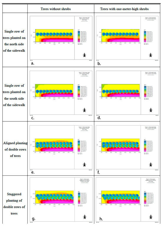
Figure 9.
PET of proposed schemes.
- Scheme a (single row of trees planted on the north side of the sidewalk without shrubs): 46.27 °C
- Scheme b (single row of trees planted on the north side of the sidewalk with one-meter-high shrubs): 46.39 °C
- Scheme c (single row of trees planted on the south side of the sidewalk without shrubs): 45.03 °C
- Scheme d (single row of trees planted on the south side of the sidewalk with one-meter-high shrubs): 45.15 °C
- Scheme e (aligned planting of double rows of trees along the sidewalk without shrubs): 45.23 °C
- Scheme f (aligned planting of double rows of trees along the sidewalk with one-meter-high shrubs): 45.31 °C
- Scheme g (staggered planting of double rows of trees along the sidewalk without shrubs): 44.84 °C
- Scheme h (staggered planting of double rows of trees along the sidewalk with one-meter-high shrubs): 44.87 °C.
Thermal comfort is influenced by factors such as air temperature, humidity, radiant temperature, and wind speed. Based on the data from various design schemes, it is evident that different tree arrangements and planting configurations exert varying impacts on microclimates, thereby indirectly affecting sidewalk thermal comfort. Among these factors, tree arrangement plays a crucial role in microclimate modulation due to the shading effect of vegetation. Consequently, the average PET effect of double rows of trees surpasses that of single rows, indicating better thermal comfort outcomes.
5. Conclusions
On the whole, the average PET of the current thermal environment within the study area is 47.09 °C. The average PET of the eight proposed planting configuration schemes in the simulation ranges from 44.84 °C to 46.27 °C. The most effective in reducing temperature is the seventh scheme, which features a staggered double row of trees without any shrubs. Compared to the current situation, the planting configuration of scheme seven reduces the temperature by 2.25 °C, effectively enhancing thermal comfort.
The analysis also reveals that the campus features a large number of impermeable pavements and suboptimal planting configurations, leading to a continuous rise in outdoor temperatures. For the surface temperature, the lowest within the study area is observed in the grassland on both sides of the sidewalk, with a minimum surface temperature of 32.08 °C recorded at noon. Conversely, the highest surface temperature is predominantly found on asphalt roads, reaching up to 54.68 °C. Additionally, numerical simulation results indicate that impermeable pavement temperatures in the study area gradually escalate under solar radiation exposure. Concrete pavement, being a material with substantial heat capacity and high heat absorption properties, exerts a considerable influence on the thermal environment. Consequently, impermeable pavement emerges as a key contributor to the campus’ poor thermal comfort. To address this issue, this study recommends the installation of more permeable pavements in campus planning, prioritizing pavement materials with lighter colors to reduce surface temperatures. This approach aims to mitigate the impact of impermeable paving on campus thermal comfort.
The effectiveness of planting configurations in improving thermal comfort is influenced by prevailing wind direction and speed, as well as solar radiation. Therefore, the selection of planting configurations should comprehensively consider the campus microclimate environment. It is advisable to avoid planting shrub species too close to sidewalks, allowing smooth airflow to carry away hot air and preventing airflow obstruction by trees, which could impede pedestrian-level wind speed. The current urban greening regulations focus solely on the amount of green space, without considering the cooling benefits brought by different planting configurations. On the other hand, the regulations only encourage the planting of multi-layered vegetation without considering that poor plant configuration might actually block airflow, leading to an increase in temperature. Consequently, the new contribution of this paper is the exploration of the interplay between planting strategies and microclimate changes in the campus environment, and the research results translate scientific empirical research data into design recommendations, ultimately creating comfortable campus spaces for users. For future studies, as the tools and software evolve, additional environmental factor settings can be integrated to more comprehensively analyze changes in the thermal environment within microclimates. The methods used in this study can also be widely applied to other engineering or physical problems, such as issues related to buildings, materials, ecological engineering, and their relationships with the environment.
Author Contributions
Conceptualization, P.-L.W.; Software, S.-J.W.; Formal analysis, P.-L.W.; Investigation, S.-J.W.; Writing—original draft, P.-L.W.; Writing—review & editing, P.-L.W.; Visualization, S.-J.W. All authors have read and agreed to the published version of the manuscript.
Funding
This research received no external funding.
Institutional Review Board Statement
Not applicable.
Informed Consent Statement
Not applicable.
Data Availability Statement
The original contributions presented in the study are included in the article, further inquiries can be directed to the corresponding author.
Conflicts of Interest
The authors declare no conflicts of interest.
References
- Erell, E.; Pearlmutter, D.; Williamson, T. Urban Microclimate: Designing the Spaces between Buildings; Routledge: London, UK, 2012; Available online: https://www.researchgate.net/publication/255989068_Urban_Microclimate_-_Designing_the_Spaces_Between_Buildings (accessed on 20 June 2022).
- Taha, H. Urban Climates and Heat Islands: Albedo, Evapotranspiration, and Anthropogenic Heat. Energy Build. 1997, 25, 99–103. [Google Scholar] [CrossRef]
- Ca, V.T.; Asaeda, T.; Abu, E.M. Reductions in Air Conditioning Energy Caused by a Nearby Park. Energy Build. 1998, 29, 83–92. [Google Scholar] [CrossRef]
- Li, J.; Zheng, B.; Chen, X.; Qi, Z.; Bedra, K.B.; Zheng, J.; Liu, L. Study on a Full-year Improvement of Indoor Thermal Comfort by Different Vertical Greening Patterns. J. Build. Eng. 2021, 35, 101969. [Google Scholar] [CrossRef]
- Chang, C.R.; Li, M.H.; Chang, S.D. A Preliminary Study on the Local Cool-island Intensity of Taipei City Parks. Landsc. Urban Plan. 2007, 80, 386–395. [Google Scholar] [CrossRef]
- Lee, H.; Mayer, H.; Kuttler, W. Impact of the Spacing between Tree Crowns on and the Mitigation of Daytime Heat Stress for Pedestrians Inside E-W Urban Street Canyons under Central European Conditions. Urban For. Urban Green. 2020, 48, 126558. [Google Scholar] [CrossRef]
- Du, H.; Yang, C. Re-Visitation of the Thermal Environment Evaluation Index Standard Effective Temperature (SET*) Based on the Two-Node Model. Sustain. Cities Soc. 2020, 53, 101899. [Google Scholar] [CrossRef]
- Lin, T.P. Thermal Perception, Adaptation and Attendance in A Public Square in Hot and Humid Regions. Build. Environ. 2009, 44, 2017–2026. [Google Scholar] [CrossRef]
- Zhang, S.; Lin, Z. Predicted Mean Vote with Skin Temperature from Standard Effective Temperature Model. Build. Environ. 2020, 183, 107133. [Google Scholar] [CrossRef]
- Gunawardena, K.R.; Wells, M.J.; Kershaw, T. Utilising Green and Bluespace to Mitigate Urban Heat Island Intensity. Sci. Total Environ. 2017, 584, 1040–1055. [Google Scholar] [CrossRef]
- Oke, T.R. The Micrometeorology of the Urban Forest. Philos. Trans. R. Soc. B 1989, 324, 335–349. [Google Scholar] [CrossRef]
- Yang, S.; Wang, L.; Stathopoulos, T.; Marey, A.M. Urban Microclimate and Its Impact on Built Environment—A Review. Build. Environ. 2023, 238, 110334. [Google Scholar] [CrossRef]
- Priya, U.K.; Senthil, R. A Review of the Impact of the Green Landscape Interventions on the Urban Microclimate of Tropical Areas. Build. Environ. 2021, 205, 108190. [Google Scholar] [CrossRef]
- Matzarakis, A.; Rutz, F.; Mayer, H. Modelling Radiation Fluxes in Simple and Complex Environments—Application of the RayMan Model. Int. J. Biometeorol. 2007, 51, 323–334. [Google Scholar] [CrossRef]
- Ketterer, C.; Matzarakis, A. Human-Biometeorological Assessment of Heat Stress Reduction by Replanning Measures in Stuttgart. Landsc. Urban Plan. 2014, 122, 78–88. [Google Scholar] [CrossRef]
- Lin, T.P.; Matzarakis, A. Tourism Climate and Thermal Comfort in Sun Moon Lake, Taiwan. Int. J. Biometeorol. 2008, 52, 281–290. [Google Scholar] [CrossRef] [PubMed]
- Mohan, M.; Gupta, A.; Bhati, S. A Modified Approach to Analyze Thermal Comfort Classification. Atmos. Clim. Sci. 2014, 4, 7–19. [Google Scholar] [CrossRef][Green Version]
- Wang, Y.; Akbari, H. The Effects of Street Tree Planting on Urban Heat Island Mitigation in Montreal. Sustain. Cities Soc. 2016, 27, 122–128. [Google Scholar] [CrossRef]
- Langenheim, N.; White, M.; Tapper, N.; Livesley, S.J.; Ramirez-Lovering, D. Right Tree, Right Place, Right Time: A Visual Functional Design Approach to Select and Place Trees for Optimal Shade Benefit to Commuting Pedestrians. Sustain. Cities Soc. 2020, 52, 101816. [Google Scholar] [CrossRef]
- Abdi, B.; Hami, A.; Zarehaghi, D. Impact of Small-Scale Tree Planting Patterns on Outdoor Cooling and Thermal Comfort. Sustain. Cities Soc. 2020, 56, 102085. [Google Scholar] [CrossRef]
- Zhang, L.; Zhan, Q.; Lan, Y. Effects of the Tree Distribution and Species on Outdoor Environment Conditions in a Hot Summer and Cold Winter Zone: A Case Study in Wuhan Residential Quarters. Build. Environ. 2018, 130, 27–39. [Google Scholar] [CrossRef]
- Chen, T.; Pan, H.; Lu, M.; Hang, J.; Lam, C.K.; Yuan, C.; Pearlmutter, D. Effects of Tree Plantings and Aspect Ratios on Pedestrian Visual and Thermal Comfort Using Scaled Outdoor Experiments. Sci. Total Environ. 2021, 801, 149527. [Google Scholar] [CrossRef] [PubMed]
- Yang, Y.; Zhou, D.; Wang, Y.; Meng, X.; Gu, Z.; Xu, D.; Han, X. Planning Method of Centralized Greening in High-Rise Residential Blocks Based on Improvement of Thermal Comfort in Summer. Sustain. Cities Soc. 2022, 80, 103802. [Google Scholar] [CrossRef]
- Perini, K.; Chokhachian, A. Modeling and Simulating Urban Outdoor Comfort: Coupling ENVI-met and TRNSYS by Grasshopper. Energy Build. 2017, 152, 373–384. [Google Scholar] [CrossRef]
- Elwy, I.; Ibrahim, Y. Outdoor Microclimatic Validation for Hybrid Simulation Workflow in Hot Arid Climates Against ENVI-met and Field Measurements. Energy Procedia 2018, 153, 29–34. [Google Scholar] [CrossRef]
- Naboni, E.; Meloni, M. An Overview of Simulation Tools for Predicting the Mean Radiant Temperature in An Outdoor Space. Energy Procedia 2017, 122, 1111–1116. [Google Scholar] [CrossRef]
- Zhang, Y.; Lin, Z.; Fang, Z.; Zheng, Z. An Improved Algorithm of Thermal Index Models Based on ENVI-met. Urban Clim. 2022, 44, 101190. [Google Scholar] [CrossRef]
Disclaimer/Publisher’s Note: The statements, opinions and data contained in all publications are solely those of the individual author(s) and contributor(s) and not of MDPI and/or the editor(s). MDPI and/or the editor(s) disclaim responsibility for any injury to people or property resulting from any ideas, methods, instructions or products referred to in the content. |
© 2024 by the authors. Licensee MDPI, Basel, Switzerland. This article is an open access article distributed under the terms and conditions of the Creative Commons Attribution (CC BY) license (https://creativecommons.org/licenses/by/4.0/).