
An Analysis of Agricultural Systems Modelling Approaches and Examples to Support Future Policy Development under Disruptive Changes in New Zealand


Abstract
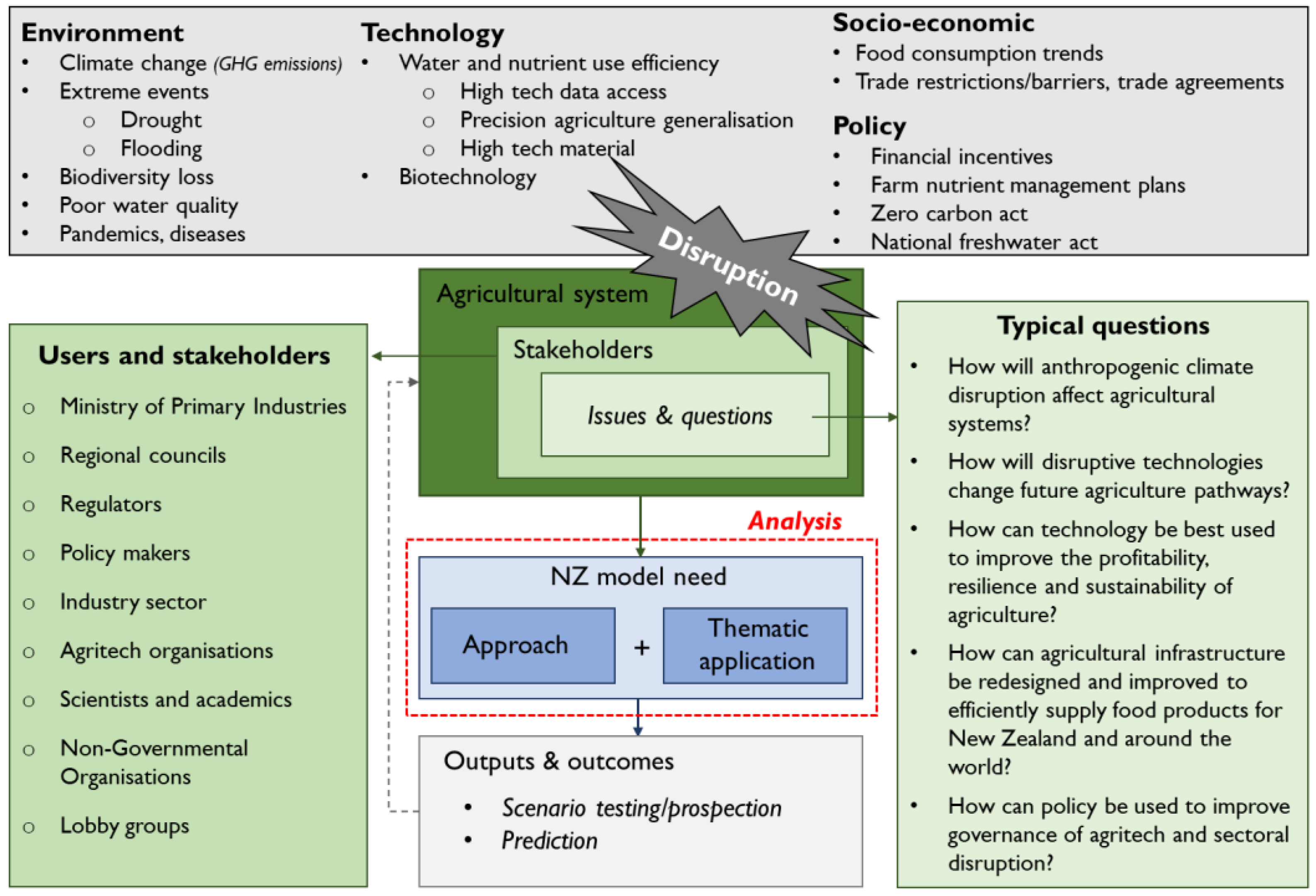
:1. Introduction
2. The New Zealand Context
3. Method
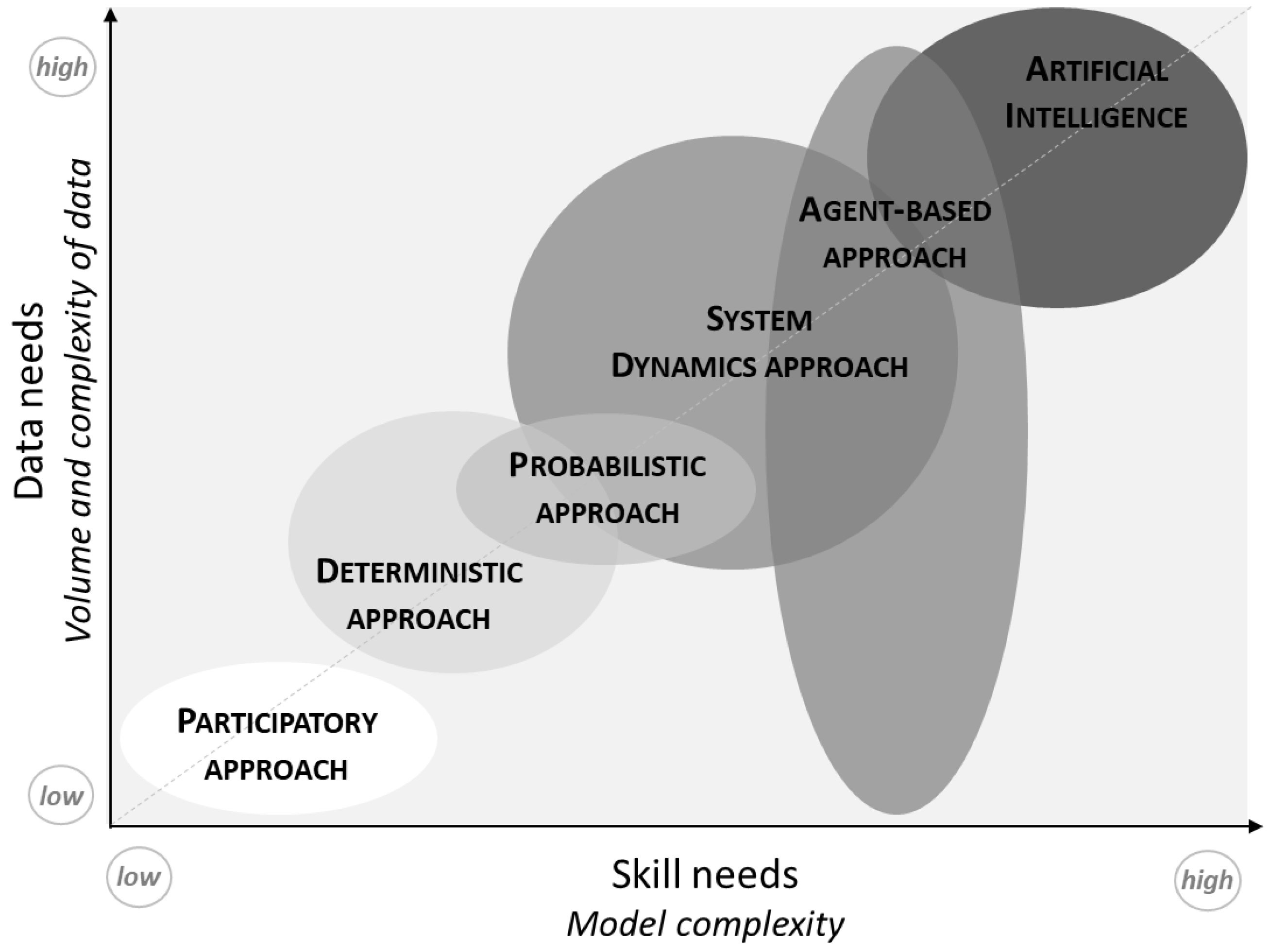
4. Analysis of Approaches to Modelling Agricultural Systems
4.1. Participatory Approach
- At a regional to national scale, the participatory approach is well designed for policy- and decision-making if it is sustained by upstream numerical modelling.
- Expert consultation can be a quicker process than numerical modelling and it does not necessarily need data or modelling skills.
- When coupled with another approach, participatory process has a real benefit to integrate stakeholders’ participation (no data can fill the “real-world” knowledge gap).
- When decision-making is the main aim, the participatory process is fundamental to gaining stakeholder buy-in.
- The participatory approach can suffer several biases, including group think, depending on the point of view of experts/stakeholders.
- It is a qualitative approach and therefore hard to quantify for coupling with other type of approaches.
4.2. Deterministic Approach
- Many models are freely available, while some are free of charge, free of copyright, and free of restrictions for modification (see Section 5). Many of these models are already parameterised for an easier application.
- Models based on deterministic approach can be coupled with all other approaches to add stochasticity or stakeholders’ involvement and be part of different scenario modelling.
4.3. Probabilistic Approach
- With a large amount of data available freely, the probabilistic approach can be easily considered both for statistical and spatial trend analysis.
- Coupling deterministic and probabilistic approaches can lead to powerful modelling of the climate change adaptation for agriculture and land-use strategies.
- Statistical models are inherently unsuited to predict the impact of major disruptions because of the historical data/parameterisation dependency for this approach.
- Analysis tools are freely available (R, Q-GIS), but advanced skills in data processing are needed.
4.4. System Dynamics Approach
- At a regional to national scale, the system dynamics approach is well designed for scenario testing and policy prospection.
- SD approach allows multi-disciplinary and multi-method integration. Other approaches can be coupled/linked with SD (participatory, deterministic, probabilistic approaches) to better emphasise the complexity of agricultural and natural resources issues.
- SD approach is suitable to reproduce agricultural systems’ organisation and to design new strategies or to experiment management/policy scenarios [96].
- The main difficulty in SD approach is validation. Especially when modelling disruptive scenarios, and when internal (model behaviour) and external (outputs) validation possibilities are limited [97]. However, a range of tools can be used to help for validation: the use of local knowledge (participatory-expertise approach) and historical data for calibration (probabilistic approach); running sensitivity analysis of key variables, or analysing scenarios and results in comparison with expert opinions (expert modellers and expert stakeholders).
- There is a risk of formulating erroneous policy by trusting simulations of invalidated models [91].
4.5. Agent-Based Approach
- At a regional to national scale, the ABM approach is well designed to simulate society or stakeholders’ behaviour facing new policy.
- ABM approach allows coupling of models (using additional physical deterministic models like crop or climate models).
- ABM approach allows for the development of conceptual models to test simple agent behaviours or the combination of behaviours under different incentives.
- ABM approach can simulate disruptions and agent adaptation capacities to a system at different organisation levels and scales.
- Like SD, it is difficult to validate ABMs, but a range of tools can be used: the validation of the conceptual framework (by external experts or stakeholders), a robust sensitivity analysis to make sure conclusions fit with the model [104].
- ABMs are not suitable for prediction but powerful for scenario testing.
4.6. Artificial Intelligence
- At a regional to national scale, the AI approach is well designed for big data exploration and sense-making from various datasets that can help to inform policy.
- AI approach is widely used for prediction and management.
- AI allows coupling various types of data and is powerful for big data analysis.
- AI techniques improve classification and prediction.
- AI modelling techniques require high skills, large datasets, and complex training procedures.
- AI approach allows for learning problems very well, but the generalisation is not possible beyond the boundaries of data and model developed (for anything untrained).
5. Analysis of Existing Models by Thematic Applications
- Decision Support Tools (DST) are developed to support decision-makers in addressing policy or conservation questions (Table 1). For example, the Integrated Sustainable Development Goals (iSDG) is a DST that was developed by the UN via the Millennium Institute to analyse the 17 SDG goals and impacts of changes for each country to help in the development of appropriate policies. The European Common Agricultural Policy Regionalised Impact (CAPRI) Modelling System is another DST example that was developed to support decision-making related to the Common Agricultural Policy [41]. The American Trade-Off Analysis-Multidimensional (TOA-MD) impact assessment model simulates economic, environmental, and social impacts of agricultural systems [38]. The Australian Multi-Criteria Analysis Shell (MCAS-S) for Spatial Decision Support allows stakeholders seeing the effects of land-use change decisions [115]. The American Agricultural Conservation Planning Framework (ACPF) identifies site-specific opportunities to install conservation practices across small watersheds [116,117,118]. The Reflexive Interactive Design (RIO) conceptual approach works as an expert consultation guideline [119,120].
- Crop models are simulation models describing the crop growth processes and development for varying weather, soil, and management conditions. Widely used crop models (Table 1) include the Agricultural Model Intercomparison and Improvement Project (AgMip) linking climate, crop, and economic modelling to improve models and project scenarios under climate change conditions for several agricultural sectors [121]. The Agricultural Production System sIMulator (APSIM) [93], the Decision Support System for Agrotechnology Transfer (DSSAT) [122], or Aquacrop model to assess crop growth, crop yield or food security issues [123]. Other crop models not presented in Table 1 included models that are focussed on enhancing scientific understanding, more complex to use, and required a large amount of data and skills.
- General water models (Table 1) are developed to understand or manage water quality and quantity of hydrological processes under different physical and management conditions. Two water models provided by FAO are CropWat, that links crop and water modelling to calculate crop water and irrigation requirements based on soil, climate, and crop data [124], and Aquastats, which monitors the SDG 6 (ensure availability and sustainable management of water and sanitation for all), and in particular on water stress and water use efficiency [125]. Other widely used water models include WaterWorld [126], developed to understand hydrological processes and water resources, and the Soil and Water Assessment Tool (SWAT), a small watershed to river basin-scale model used to simulate the quality and quantity of surface and ground water, and predict the environmental impact of land use, land management practices, and climate change [127,128]. Additionally, many multi-service platforms provide general water modelling tools.
- Greenhouse gas emission (GHG) calculators mostly focus on deterministically estimating carbon and methane emissions (Table 1). Among GHG calculators [129], easy-to-use models that provide great added value on mitigation possibilities include the Ex-Ante Carbon-balance Value Chain Tool (Ex-ACT VC) developed by FAO to increase resilience of populations and ecosystems, and to decarbonize the global economy [130,131], the Agro Chain Greenhouse Gas Emission calculator (ACGE), which estimates total GHG emissions associated with food products [132], and the Climate Change, Agriculture and Food Security-Mitigation Options Tool (CCAFS-MOT), a mitigation options tool estimating GHG emissions from multiple crop and livestock management practices [133].
- Climate models take into account complex atmosphere–ocean–land surface–cryosphere interactions through physics-based knowledge. A full review of climate models is out of the scope of this paper, but the Climate Analogues model provided by FAO [134] caught our attention for its adaptation-focus approach (Table 1). This model identifies areas that experience statistically similar climatic conditions, but which may be separated temporally and/or spatially. The approach allows locating areas whose climate today is similar to the projected future climate of a place of interest, or vice versa. The approach allows comparing agricultural systems working in “future” climate conditions to help define adaptation strategies.
- Multi-service platforms are a shell of models related to Ecosystem Services quantification, mapping, and modelling. They group agricultural production, carbon stock, pollination, water quality, and other models together (Table 1). Multi-service platforms include the widely used Integrated Valuation of Ecosystem Services and Tradeoffs (InVest) [43], the Toolkit for Ecosystem Service Site-Based Assessment (TESSA) [135], or the Co$ting Nature platforms developed to explore how changes in ecosystems can lead to changes in the flows of many different benefits to people [136].

| Model Application | Modelling Approach | Model Name | Spatial Scale | Input Data Needs | Model Aim | Skills Needed | Strengths (+)/ Weaknesses (−) | Comments | References |
|---|---|---|---|---|---|---|---|---|---|
| Decision support tool | System dynamics | Integrated Sustainable Development Goals (iSDG) | National scale, country-based model. | Worldwide data on social, economic, and environmental sectors. | Policy simulation tool designed to help policy-makers and stakeholders make sense of interconnections between the SDGs. iSDG focuses the dynamic interactions within the SDG system to reveal the best paths and progression towards achieving the SDGs. | Model open for collaboration with the iSDG team to develop own country’s example. | +: Already implemented model around the 17 SDGs defined by the Millennium Institute. | Developed first for food security issues; also used for other questions like clean energy use in the USA. Could be interested to develop for a carbon-neutral objective. | [40] https://www.millennium-institute.org/isdg (accessed on 1 December 2021) |
| −: Not agricultural system model only. Wider than agricultural sector. Non-spatial modelling. Indicator scores only. | |||||||||
| System dynamics | Common Agricultural Policy Regionalised Impact (CAPRI) modelling system | European Union (27) +Norway, Western Balkans, Turkey scale, NUTS2 scale (280 regions), and 10 farm types for each region. | Economic data, farm/market balance, unit value prices, policy variables. Data provided by FAOSTAT and Eurostat. | Economic model developed by EU to support decision-making related to the Common Agricultural Policy based on scientific quantitative analysis. | High skills (GIS, programmation). | +: Already developed, stable, and complete process for EU. Spatial modelling. | Multifunctionality indicators analysis (food security, landscape, environment, rural viability), applied to the agricultural sector, with an economic model. | [41] https://www.capri-model.org/dokuwiki/doku.php (accessed on 1 December 2021) | |
| −: Can be adapted to other countries around the world but with heavy development to plan. | |||||||||
| System dynamics | Tradeoff Analysis—Multi Dimensional impact assessment (TOA-MD) | National, regional to local scale. | Whole farm system (crops, livestock, aquaculture, income), simulating economic indicators, threshold indicators for any other quantifiable economic, environmental, or social outcome. | Model developed to improve the understanding of agricultural system sustainability and inform policy decisions. TOA-MD can be used to analyse technology adoption, payment of ecosystem services, environmental change impact, and adaptation. | Medium to high skills. | +: Already developed, stable, and complete process. Free and easy access to the full model. Model link with AgMIP crop model. Spatial modelling. | Developed by Oregon State University/USA Can be requested by registration form online. | [38] https://agsci.oregonstate.edu/tradeoffs/about-toa (accessed on 1 December 2021) | |
| Deterministic/Probabilistic | Multi-Criteria Analysis Shell for Spatial Decision Support (MCAS-S) | International, national, regional, and catchment scale. | GIS data/map layers. | MCAS-S informs spatial decision-making and help with stakeholder engagement. Model shows transparently how mapped information can be combined to meet an objective. Model allows stakeholders to see the effects that their decisions may have. | Medium to high GIS skills. | +: Already developed, stable, and complete process. Free and easy access to the full model. Already used for several resources management and adaptation. Spatial and multi-criteria statistical modelling. | Developed by the Australian Department of Agriculture, Water and the Environment. Download available for free. | [115] https://www.agriculture.gov.au/abares/aclump/multi-criteria-analysis (accessed on 1 December 2021) | |
| Deterministic/Probabilistic | Agricultural Conservation Planning Framework (ACPF) | Watershed to regional scale. | GIS land use and soils. | ACPF informs and engages local producers in agricultural conservation. It helps in engaging with stakeholders and building conservation solutions. | Medium to high GIS skills. | +: ArcGis toolbox module. Users are able to build their own database. Spatial and multi-criteria statistical modelling. | Model available for free as an ArcGis module. Already used by conservation planners, project coordinators, agency staff etc. | [116,117,118] https://acpf4watersheds.org/ (accessed on 1 December 2021) | |
| Participatory approach | Reflexive Interactive Design (RIO) | Aspatial, conceptual process. | Expert consultation approach, need for knowledge, not data. | RIO structurally addresses complex trade-offs and contributes by process and design to change towards sustainable development. | Low skills, but high field or system knowledge needed. | +: First step to design a new system approach. Interesting for stakeholders’ engagement without any skills requested. | – | [119,120] ActionCatalogue-method (accessed on 1 December 2021) | |
| −: No quantification nor spatial analysis. Only conceptual approach. | |||||||||
| Crop Model | Physical/ Deterministic | Agricultural Model Intercomparison and Improvement Project (AgMIP) | World to national scale. | Worldwide data on climate, crops, and economy. | AgMIP was developed to improve agricultural models for assessing impacts of climate variability and change and other driving forces on agriculture, food security, and poverty. | Medium to low computational skills. | +: Use worldwide dataset, good for country comparisons. Online model with data translator. | Developed for food security issues. | [121] https://agmip.org/ (accessed on 1 December 2021) |
| −: Only sectoral applications, no general overview of agricultural systems. | |||||||||
| Physical/ Deterministic | Agricultural Production System Simulator (APSIM) | Global to local scale. | Field data and observation needed. | APSIM is a highly advanced model for modelling and simulation of agricultural systems. It contains a suite of modules that enable the simulation of systems for a diverse range of plant, animal, soil, climate, and management interactions. | High skills on crop modelling needed. | +: Very precise farming model. More than only crops. Online download available for free. | Based on crop model, with other parameters larger than only crops (like livestock, and climate variability effects). Developed in Australia and New Zealand. | [93] https://www.apsim.info/ (accessed on 1 December 2021) | |
| −: Not easy to use. Require very precise agronomic knowledge. No spatial component. | |||||||||
| Physical/ Deterministic | Decision Support System for Agrotechnology Transfer (DSSAT) | Aspatial model. | 42 crops implemented, database management for soil, weather, crop management, experimental data. | The DSSAT crop model simulates growth, development, and yield as a function of the soil–plant–atmosphere dynamics. | High skills on crop modelling needed. | +: already implemented for 42 crops. | Online download available for free. | [122] https://dssat.net/about/ (accessed on 1 December 2021) | |
| −: Crop model only. | |||||||||
| Physical/ Deterministic | AquaCrop | Aspatial model. | Weather data, crop and soil characteristics, management practices. | Crop growth model developed by the Land and Water Division of FAO to address food security and to assess the effect of environment and management on crop production. Crop yield prediction model under vertical conditions. | Medium to high skills in crop modelling and agronomy. | +: Good to assist for management decisions on irrigation or on crop response to environmental changes. | Software available online for free. Provided by FAO. | [123] http://www.fao.org/aquacrop/overview/whatisaquacrop/en/ (accessed on 1 December 2021) | |
| −: No spatial component. | |||||||||
| Water/Crop model | Physical/ Deterministic | CropWat | Aspatial, farmer to landscape resolution. | Crop, soil, climate data. Decade and daily calculation of crop water requirements. | Calculation of crop water requirements and irrigation requirements based on soil, climate, and crop data. CROPWAT can also be used to evaluate farmers’ irrigation practices and to estimate crop performance under both rain-fed and irrigated conditions. | Medium agronomical skills. | +: Software freely available online. Allow the development of irrigation schedule. | Provided by FAO. | [124] http://www.fao.org/land-water/databases-and-software/cropwat/en/ (accessed on 1 December 2021) |
| −: Work firstly at farm scale; can be used at small catchment scale. | |||||||||
| Water/Crop model | Physical/ Deterministic | Soil and Water Assessment Tool (SWAT) | Small watershed to river basin. | GIS topography, land use, soil, climate data. | Simulation of the quality and quantity of surface and ground water. Prediction of the environmental impact of land use, land management practices, and climate change. | High water, GIS and, modelling skills. | +: Spatial modelling. Already widely used in assessing soil erosion prevention and control, non-point source pollution control, and regional management in watersheds. Software available for free with a GIS connection. | Data can be provided online from available world data to help build own model. | [127,128] https://swat.tamu.edu/ (accessed on 1 December 2021) |
| Water | Physical/ Deterministic | AQUASTAT | Global, regional, national scale. | Worldwide data on water resources, water use, and agricultural water management. | AQUASTAT is monitoring of the Sustainable Development Goal 6 that sets out to “ensure availability and sustainable management of water and sanitation for all”, and, in particular, on water stress and water use efficiency. | Medium data analysis skills to collect and bring together information. | +: Model outputs already available. | Provided by FAO. | [125] http://www.fao.org/aquastat/en/ (accessed on 1 December 2021) |
| −: Low resolution, but already processed. | |||||||||
| Physical/ Deterministic | WaterWorld | Large to fine scale. | Data provided from remote sensing or other global sources. Own data sources can be used. | Waterworld aims to understand the hydrological and water resources baseline and water risk factors associated with specific activities under current conditions, and under scenarios for land use, land management, and climate change. | Medium to low as default parameters and data are provided. More complicated to use with own data and precise parameterisation at a local scale. | +: Quick and relatively easy to use. Allow scenarios, spatial model, spatial outputs. | Used detailed spatial datasets at 1 km2 and 1 ha resolution for the entire world. Spatial model for biophysical and socio-economic processes along with scenarios for climate, land use, and economic change. | [126] http://www.policysupport.org/waterworld (accessed on 1 December 2021) | |
| GHG emission calculator | Physical/ Deterministic | Ex-Ante Carbon-balance Tool value chain (EX-ACT VC) | From local to national scale. | Worldwide data provided by FAO. | EX-ACT VC aims to develop sustainable and performant food value chain in order to eradicate poverty in rural areas, to increase resilience of populations and ecosystems, and to decarbonize our global economy. | Medium to low data skills. | +: Works as a decision support tool. Indicators like value added, employment, water use, emissions, food loss and waste, and resilience are monitored by the model. | Excel software/indicators open access and free download. Provided by FAO. | [130,131] http://www.fao.org/tc/exact/ex-act-vc/en/ (accessed on 1 December 2021) |
| Physical/ Deterministic | Agro chain greenhouse gas emission (ACGE) | From world to regional scale, per agricultural production type. | Regional data, specific data on transport and packaging. | ACGE estimates total GHG emissions associated with a food product. It addresses the most common stages of “linear” agro-food chains (chains for fresh and simple processed products: canned, frozen, packaged, and other minimally processed forms). | Low skill, Excel sheet to fill. | +: Default data are already implemented. General indices. Large regional indices. | Very easy to use Excel sheet. Quick to obtain indices on general GHG emission per agricultural production type. Clear guidelines provided. | [132] https://ccafs.cgiar.org/agro-chain-greenhouse-gas-emissions-acge-calculator#.Xvq6hCgzYuU (accessed on 1 December 2021) | |
| −: Not easy to downscale at national scale. | |||||||||
| Physical/ Deterministic | Climate Change, Agriculture and Food Security—Mitigation Options Tool (CCAFS-MOT) | Regional to national scale. | General data on national climate, soil, crop, and grassland management. | Model estimates greenhouse gas emissions from multiple crop and livestock management practices, providing policy-makers with access to reliable information needed to make science-informed decisions about emission reductions from agriculture. | Low skill, Excel sheet to fill. | +: Easy to use. FAO data can provide all the needed inputs. | Very efficient tool providing emissions and mitigation potentials for crops, grasslands, and livestock. | [133] https://cgspace.cgiar.org/handle/10568/67027 (accessed on 1 December 2021) | |
| Climate Models | Probabilistic | Climate Analogues | Worldwide. | Use current climate data from WorldClim aggregated to 2 degrees, (1970–2000). Future climate data come from CCAFS-Climate for all CMIP5 and RCPs. | The models identify areas that experience statistically similar climatic conditions, but which may be separated temporally and/or spatially. The approach allows locating areas whose climate today is similar to the projected future climate of a place of interest, or vice versa. | Medium to low skill. | +: Easy to use data are already implemented. Model is running with R. | Very interesting to compare the future climate of a region of interest with other places in the world and what agriculture can look like. Good for building mitigation options rapidly. Provided by FAO. | [134] https://www.ccafs-analogues.org/ (accessed on 1 December 2021) |
| −: No downscaling allowed. | |||||||||
| Multi-service platform | Physical/Deterministic | Integrated Valuation of Ecosystem Services and Tradeoffs (InVest) | Local to global scale. | Spatial resolution and data input are flexible (wide range of environmental modelling). | Suite of models used to map and value the goods and services from nature that sustain and fulfill human life. It helps explore how changes in ecosystems can lead to changes in the flows of many different benefits to people. | Medium to high. Need GIS and mapping skills to build own data and analyse outputs. | +: Spatial modelling of a wide range of ES. Allow spatial inputs and outputs. Can be used with other model outputs in a GIS. | Almost 20 models available for free such as: carbon, pollination, habitat quality, reservoir hydropower, crop production, habitat risk assessment, sediment retention, water purification, etc. | [43] https://naturalcapitalproject.stanford.edu/software/invest (accessed on 1 December 2021) |
| Physical/Deterministic | Toolkit for Ecosystem Service Site-Based Assessment (TESSA) | Local to global scale. | Land-use data, default parameters provided. | TESSA aims to understand the impacts on natural capital and ecosystem services of actual and potential changes in state at individual sites. TESSA aims to promote better planning decisions to support both biodiversity conservation and ecosystem service delivery. | Medium to low: guides for non-specialist users through various methods for rapidly quantifying a range of ecosystem services. | +: Toolkit, multi-indicators, ES-based, developed for decision-making. Can be used by non-experts. | ES approach, not agricultural approach. Evaluate a range of 10 ES (nutrition, water supply, materials, energy, regulation of biophysical, flow, physico-chemical, biotic environment, 2 cultural ES). | [135] http://tessa.tools/ (accessed on 1 December 2021) | |
| Physical/Deterministic | Co$ting Nature | Worldwide. | Spatial datasets at 1 km2 and 1 ha resolution for the entire world. | A web-based tool for natural capital accounting and analysing the ecosystem services provided by natural environments (i.e., nature’s benefits), identifying the beneficiaries of these services, and assessing the impacts of human interventions. | Medium to low. | +: Online platform with already implemented data. | Spatial models for biophysical and socio-economic processes along with scenarios for climate and land use. | [136] http://www.policysupport.org/self-paced-training/costingnature-english (accessed on 1 December 2021) | |
| −: Target Ecosystem Services, more for conservation and development, less for only agricultural purposes. No downscaling available. |
6. Discussion
6.1. Range of Model Approaches and Thematic Applications
6.2. Limits, Margin of Progress, and Recommendations for Future New Zealand Development
- Clearly identify the question(s) to be answered or the objectives of the modelling initiative.
- Assess the data available for modelling (qualitative, quantitative, statistical databases, field observations, GIS maps, etc.). The data available will help refine the modelling approach to use and model thematic application, and if needed, help identify what additional data needs to be collected.
- Evaluate existing models and their adaptation potential to address the modelling requirements. Consideration for the type of approach needed, model thematic application, and model availability will depend on items 1 and 2 above. Furthermore, consideration should be given to a combination of modelling approaches to address all requirements, if necessary.
7. Conclusions
Author Contributions
Funding
Conflicts of Interest
References
- Keith, H.; Vardon, M.; Stein, J.A.; Stein, J.L.; Lindenmayer, D. Ecosystem Accounts Define Explicit and Spatial Trade-Offs for Managing Natural Resources. Nat. Ecol. Evol. 2017, 1, 1683–1692. [Google Scholar] [CrossRef] [PubMed]
- Rolnick, D.; Donti, P.L.; Kaack, L.H.; Kochanski, K.; Lacoste, A.; Sankaran, K.; Ross, A.S.; Milojevic-Dupont, N.; Jaques, N.; Waldman-Brown, A.; et al. Tackling Climate Change with Machine Learning. arXiv 2019, arXiv:1906.05433. [Google Scholar] [CrossRef]
- Wang, X.; Daigger, G.; Lee, D.-J.; Liu, J.; Ren, N.-Q.; Qu, J.; Liu, G.; Butler, D. Evolving Wastewater Infrastructure Paradigm to Enhance Harmony with Nature. Sci. Adv. 2018, 4, eaaq0210. [Google Scholar] [CrossRef] [PubMed] [Green Version]
- Janssens, C.; Havlík, P.; Krisztin, T.; Baker, J.; Frank, S.; Hasegawa, T.; Leclère, D.; Ohrel, S.; Ragnauth, S.; Schmid, E.; et al. Global Hunger and Climate Change Adaptation through International Trade. Nat. Clim. Chang. 2020, 10, 829–835. [Google Scholar] [CrossRef] [PubMed]
- Porfirio, L.L.; Newth, D.; Finnigan, J.J.; Cai, Y. Economic Shifts in Agricultural Production and Trade Due to Climate Change. Palgrave Commun. 2018, 4, 111. [Google Scholar] [CrossRef]
- Mason-D’Croz, D.; Bogard, J.R.; Herrero, M.; Robinson, S.; Sulser, T.B.; Wiebe, K.; Willenbockel, D.; Godfray, H.C.J. Modelling the Global Economic Consequences of a Major African Swine Fever Outbreak in China. Nat. Food 2020, 1, 221–228. [Google Scholar] [CrossRef] [PubMed] [Green Version]
- Tian, X.; von Cramon-Taubadel, S. Economic Consequences of African Swine Fever. Nat. Food 2020, 1, 196–197. [Google Scholar] [CrossRef]
- Friel, S.; Schram, A.; Townsend, B. The Nexus between International Trade, Food Systems, Malnutrition and Climate Change. Nat. Food 2020, 1, 51–58. [Google Scholar] [CrossRef] [Green Version]
- Burton, R.J.F. The Potential Impact of Synthetic Animal Protein on Livestock Production: The New “War against Agriculture”? J. Rural Stud. 2019, 68, 33–45. [Google Scholar] [CrossRef]
- Collins, C.M.; Vaskou, P.; Kountouris, Y. Insect Food Products in the Western World: Assessing the Potential of a New ‘Green’ Market. Ann. Entomol Soc. Am. 2019, 112, 518–528. [Google Scholar] [CrossRef]
- Mouat, M.J.; Prince, R. Cultured Meat and Cowless Milk: On Making Markets for Animal-Free Food. J. Cult. Econ. 2018, 11, 315–329. [Google Scholar] [CrossRef]
- Wang, X.; Dou, Z.; Shi, X.; Zou, C.; Liu, D.; Wang, Z.; Guan, X.; Sun, Y.; Wu, G.; Zhang, B.; et al. Innovative Management Programme Reduces Environmental Impacts in Chinese Vegetable Production. Nat. Food 2021, 2, 47–53. [Google Scholar] [CrossRef]
- Zhang, P.; Guo, Z.; Ullah, S.; Melagraki, G.; Afantitis, A.; Lynch, I. Nanotechnology and Artificial Intelligence to Enable Sustainable and Precision Agriculture. Nat. Plants 2021, 7, 864–876. [Google Scholar] [CrossRef] [PubMed]
- Roque, B.M.; Venegas, M.; Kinley, R.D.; de Nys, R.; Duarte, T.L.; Yang, X.; Kebreab, E. Red Seaweed (Asparagopsis Taxiformis) Supplementation Reduces Enteric Methane by over 80 Percent in Beef Steers. PLoS ONE 2021, 16, e0247820. [Google Scholar] [CrossRef] [PubMed]
- White, L.N.; White, W.L. Seaweed Utilisation in New Zealand. Bot. Mar. 2020, 63, 303–313. [Google Scholar] [CrossRef]
- Greenland, S.J.; Dalrymple, J.; Levin, E.; O’Mahony, B. Improving Agricultural Water Sustainability: Strategies for Effective Farm Water Management and Encouraging the Uptake of Drip Irrigation. In The Goals of Sustainable Development: Responsibility and Governance; Approaches to Global Sustainability, Markets, and Governance; Crowther, D., Seifi, S., Moyeen, A., Eds.; Springer: Singapore, 2018; pp. 111–123. ISBN 978-981-10-5047-3. [Google Scholar]
- Knickel, K.; Redman, M.; Darnhofer, I.; Ashkenazy, A.; Calvão Chebach, T.; Šūmane, S.; Tisenkopfs, T.; Zemeckis, R.; Atkociuniene, V.; Rivera, M.; et al. Between Aspirations and Reality: Making Farming, Food Systems and Rural Areas More Resilient, Sustainable and Equitable. J. Rural Stud. 2018, 59, 197–210. [Google Scholar] [CrossRef] [Green Version]
- Stephens, E.C.; Martin, G.; van Wijk, M.; Timsina, J.; Snow, V. Editorial: Impacts of COVID-19 on Agricultural and Food Systems Worldwide and on Progress to the Sustainable Development Goals. Agric. Syst. 2020, 183, 102873. [Google Scholar] [CrossRef]
- FAO Sustainable Food and Agriculture-News. Available online: http://www.fao.org/sustainability/news/detail/en/c/1274219/ (accessed on 12 April 2021).
- Lynch, J.; Cain, M.; Frame, D.; Pierrehumbert, R. Agriculture’s Contribution to Climate Change and Role in Mitigation Is Distinct From Predominantly Fossil CO2-Emitting Sectors. Front. Sustain. Food Syst. 2021, 4, 518039. [Google Scholar] [CrossRef]
- Morecroft, M.D.; Duffield, S.; Harley, M.; Pearce-Higgins, J.W.; Stevens, N.; Watts, O.; Whitaker, J. Measuring the Success of Climate Change Adaptation and Mitigation in Terrestrial Ecosystems. Science 2019, 366, eaaw9256. [Google Scholar] [CrossRef] [Green Version]
- Fu, B.; Merritt, W.S.; Croke, B.F.W.; Weber, T.R.; Jakeman, A.J. A Review of Catchment-Scale Water Quality and Erosion Models and a Synthesis of Future Prospects. Environ. Model. Softw. 2019, 114, 75–97. [Google Scholar] [CrossRef]
- Liu, Y.; Engel, B.A.; Flanagan, D.C.; Gitau, M.W.; McMillan, S.K.; Chaubey, I. A Review on Effectiveness of Best Management Practices in Improving Hydrology and Water Quality: Needs and Opportunities. Sci. Total Environ. 2017, 601–602, 580–593. [Google Scholar] [CrossRef] [PubMed]
- Melland, A.R.; Fenton, O.; Jordan, P. Effects of Agricultural Land Management Changes on Surface Water Quality: A Review of Meso-Scale Catchment Research. Environ. Sci. Policy 2018, 84, 19–25. [Google Scholar] [CrossRef]
- Dudley, N.; Alexander, S. Agriculture and Biodiversity: A Review. Biodiversity 2017, 18, 45–49. [Google Scholar] [CrossRef]
- Ortiz, A.M.D.; Outhwaite, C.L.; Dalin, C.; Newbold, T. A Review of the Interactions between Biodiversity, Agriculture, Climate Change, and International Trade: Research and Policy Priorities. One Earth 2021, 4, 88–101. [Google Scholar] [CrossRef]
- Pe’er, G.; Dicks, L.V.; Visconti, P.; Arlettaz, R.; Báldi, A.; Benton, T.G.; Collins, S.; Dieterich, M.; Gregory, R.D.; Hartig, F.; et al. EU Agricultural Reform Fails on Biodiversity. Science 2014, 344, 1090–1092. [Google Scholar] [CrossRef] [PubMed]
- Gil, J.D.B.; Reidsma, P.; Giller, K.; Todman, L.; Whitmore, A.; van Ittersum, M. Sustainable Development Goal 2: Improved Targets and Indicators for Agriculture and Food Security. Ambio 2019, 48, 685–698. [Google Scholar] [CrossRef] [Green Version]
- Lee, K.-H.; Noh, J.; Khim, J.S. The Blue Economy and the United Nations’ Sustainable Development Goals: Challenges and Opportunities. Environ. Int. 2020, 137, 105528. [Google Scholar] [CrossRef]
- MEA. Ecosystems and Human Well-Being: Biodiversity Synthesis; Millennium Ecosystem Assessment: Washington, DC, USA, 2005. [Google Scholar]
- CBD (Convention on Biological Diversity). Aichi Biodiversity Targets of the Strategic Plan 2011–2020. Available online: https://www.cbd.int/sp/targets/ (accessed on 20 August 2020).
- Gao, L.; Bryan, B.A. Finding Pathways to National-Scale Land-Sector Sustainability. Nature 2017, 544, 217–222. [Google Scholar] [CrossRef]
- Bishop, M.L.; Xiaotong, Z. Why Is China a Reluctant Leader of the World Trade Organization? New Political Econ. 2020, 25, 755–772. [Google Scholar] [CrossRef]
- Margulis, M.E. The World Trade Organization between Law and Politics: Negotiating a Solution for Public Stockholding for Food Security Purposes. Transnatl. Leg. Theory 2018, 9, 343–360. [Google Scholar] [CrossRef]
- Urruty, N.; Tailliez-Lefebvre, D.; Huyghe, C. Stability, Robustness, Vulnerability and Resilience of Agricultural Systems. A Review. Agron. Sustain. Dev. 2016, 36, 15. [Google Scholar] [CrossRef] [Green Version]
- Kaddoura, S.; El Khatib, S. Review of Water-Energy-Food Nexus Tools to Improve the Nexus Modelling Approach for Integrated Policy Making. Environ. Sci. Policy 2017, 77, 114–121. [Google Scholar] [CrossRef]
- Kelly (Letcher), R.A.; Jakeman, A.J.; Barreteau, O.; Borsuk, M.E.; ElSawah, S.; Hamilton, S.H.; Henriksen, H.J.; Kuikka, S.; Maier, H.R.; Rizzoli, A.E.; et al. Selecting among Five Common Modelling Approaches for Integrated Environmental Assessment and Management. Environ. Model. Softw. 2013, 47, 159–181. [Google Scholar] [CrossRef]
- Antle, J.M.; Ray, S. Sustainable Agricultural Development: An Economic Perspective; Palgrave Studies in Agricultural Economics and Food Policy; Palgrave Macmillan: London, UK, 2020; ISBN 978-3-030-34598-3. [Google Scholar]
- Jones, J.W.; Antle, J.M.; Basso, B.; Boote, K.J.; Conant, R.T.; Foster, I.; Godfray, H.C.J.; Herrero, M.; Howitt, R.E.; Janssen, S.; et al. Brief History of Agricultural Systems Modeling. Agric. Syst. 2017, 155, 240–254. [Google Scholar] [CrossRef] [PubMed]
- Millennium Institute ISDG Model Documentation 2017. Available online: https://isdgdoc.millennium-institute.org/en/ (accessed on 16 January 2022).
- Mittenzwei, K.; Fjellstad, W.; Dramstad, W.; Flaten, O.; Gjertsen, A.K.; Loureiro, M.; Prestegard, S.S. Opportunities and Limitations in Assessing the Multifunctionality of Agriculture within the CAPRI Model. Ecol. Indic. 2007, 7, 827–838. [Google Scholar] [CrossRef]
- Qu, W.; Shi, W.; Zhang, J.; Liu, T. T21 China 2050: A Tool for National Sustainable Development Planning. Geogr. Sustain. 2020, 1, 33–46. [Google Scholar] [CrossRef]
- Sharp, R.; Chaplin-Kramer, R.; Wood, S.; Guerry, A.; Tallis, H.; Ricketts, T.; Nelson, E.; Ennaanay, D.; Wolny, S.; Olwero, N.; et al. InVEST User’s Guide; The Natural Capital Project, Stanford University, University of Minnesota, The Nature Conservancy, and World Wildlife Fund: Arlington, VA, USA, 2018. [Google Scholar]
- Ministry for the Environment Agriculture Emissions and Climate Change. Available online: https://environment.govt.nz/guides/agriculture-emissions-climate-change/ (accessed on 14 September 2021).
- Arksey, H.; O’Malley, L. Scoping Studies: Towards a Methodological Framework. Int. J. Soc. Res. Methodol. 2005, 8, 19–32. [Google Scholar] [CrossRef] [Green Version]
- Romera, A.J.; Bos, A.P.; Neal, M.; Eastwood, C.R.; Chapman, D.; McWilliam, W.; Royds, D.; O’Connor, C.; Brookes, R.; Connolly, J.; et al. Designing Future Dairy Systems for New Zealand Using Reflexive Interactive Design. Agric. Syst. 2020, 181, 102818. [Google Scholar] [CrossRef]
- Lamarque, P.; Artaux, A.; Barnaud, C.; Dobremez, L.; Nettier, B.; Lavorel, S. Taking into Account Farmers’ Decision Making to Map Fine-Scale Land Management Adaptation to Climate and Socio-Economic Scenarios. Landsc. Urban. Plan. 2013, 119, 147–157. [Google Scholar] [CrossRef]
- Pirotta, E.; New, L.; Marcoux, M. Modelling Beluga Habitat Use and Baseline Exposure to Shipping Traffic to Design Effective Protection against Prospective Industrialization in the Canadian Arctic. Aquat. Conserv. Mar. Freshw. Ecosyst. 2018, 28, 713–722. [Google Scholar] [CrossRef]
- Vannier, C.; Bierry, A.; Longaretti, P.-Y.; Nettier, B.; Cordonnier, T.; Chauvin, C.; Bertrand, N.; Quétier, F.; Lasseur, R.; Lavorel, S. Co-Constructing Future Land-Use Scenarios for the Grenoble Region, France. Landsc. Urban. Plan. 2019, 190, 103614. [Google Scholar] [CrossRef] [Green Version]
- Harrison, P.A.; Dunford, R.; Savin, C.; Rounsevell, M.D.A.; Holman, I.P.; Kebede, A.S.; Stuch, B. Cross-Sectoral Impacts of Climate Change and Socio-Economic Change for Multiple, European Land- and Water-Based Sectors. Clim. Change 2015, 128, 279–292. [Google Scholar] [CrossRef]
- Bohunovsky, L.; Jäger, J.; Omann, I. Participatory Scenario Development for Integrated Sustainability Assessment. Reg. Environ. Change 2011, 11, 271–284. [Google Scholar] [CrossRef]
- Nieto-Romero, M.; Milcu, A.; Leventon, J.; Mikulcak, F.; Fischer, J. The Role of Scenarios in Fostering Collective Action for Sustainable Development: Lessons from Central Romania. Land Use Policy 2016, 50, 156–168. [Google Scholar] [CrossRef]
- Bos, A.P.; Koerkamp, P.W.G.G.; Gosselink, J.M.J.; Bokma, S. Reflexive Interactive Design and Its Application in a Project on Sustainable Dairy Husbandry Systems. Outlook Agric. 2009, 38, 137–145. [Google Scholar] [CrossRef] [Green Version]
- Elzen, B.; Bos, B. The RIO Approach: Design and Anchoring of Sustainable Animal Husbandry Systems. Technol. Forecast. Soc. Change 2019, 145, 141–152. [Google Scholar] [CrossRef]
- Yelapure, S.J.; Kulkarni, D.R.V. Literature Review on Expert System in Agriculture. Int. J. Comput. Sci. Inf. Technol. 2012, 3, 5086–5089. [Google Scholar]
- Kanter, D.R.; Schwoob, M.-H.; Baethgen, W.E.; Bervejillo, J.E.; Carriquiry, M.; Dobermann, A.; Ferraro, B.; Lanfranco, B.; Mondelli, M.; Penengo, C.; et al. Translating the Sustainable Development Goals into Action: A Participatory Backcasting Approach for Developing National Agricultural Transformation Pathways. Glob. Food Secur. 2016, 10, 71–79. [Google Scholar] [CrossRef]
- Kebede, A.S.; Nicholls, R.J.; Allan, A.; Arto, I.; Cazcarro, I.; Fernandes, J.A.; Hill, C.T.; Hutton, C.W.; Kay, S.; Lázár, A.N.; et al. Applying the Global RCP–SSP–SPA Scenario Framework at Sub-National Scale: A Multi-Scale and Participatory Scenario Approach. Sci. Total Environ. 2018, 635, 659–672. [Google Scholar] [CrossRef]
- Nyam, Y.S.; Kotir, J.H.; Jordaan, A.J.; Ogundeji, A.A.; Turton, A.R. Drivers of Change in Sustainable Water Management and Agricultural Development in South Africa: A Participatory Approach. Sustain. Water Resour. Manag. 2020, 6, 62. [Google Scholar] [CrossRef]
- Bergez, J.E.; Raynal, H.; Launay, M.; Beaudoin, N.; Casellas, E.; Caubel, J.; Chabrier, P.; Coucheney, E.; Dury, J.; Garcia de Cortazar-Atauri, I.; et al. Evolution of the STICS Crop Model to Tackle New Environmental Issues: New Formalisms and Integration in the Modelling and Simulation Platform RECORD. Environ. Model. Softw. 2014, 62, 370–384. [Google Scholar] [CrossRef]
- Brisson, N.; Mary, B.; Ripoche, D.; Jeuffroy, M.H.; Ruget, F.; Nicoullaud, B.; Gate, P.; Devienne-Barret, F.; Antonioletti, R.; Durr, C.; et al. STICS: A Generic Model for the Simulation of Crops and Their Water and Nitrogen Balances. I. Theory and Parameterization Applied to Wheat and Corn. Agronomie 1998, 18, 311–346. [Google Scholar] [CrossRef]
- Parker, A.K.; García de Cortázar-Atauri, I.; Gény, L.; Spring, J.-L.; Destrac, A.; Schultz, H.; Molitor, D.; Lacombe, T.; Graça, A.; Monamy, C.; et al. Temperature-Based Grapevine Sugar Ripeness Modelling for a Wide Range of Vitis Vinifera L. Cultivars. Agric. For. Meteorol. 2020, 285–286, 107902. [Google Scholar] [CrossRef]
- Lasseur, R.; Vannier, C.; Lefebvre, J.; Longaretti, P.-Y.; Lavorel, S. Landscape-Scale Modeling of Agricultural Land Use for the Quantification of Ecosystem Services. J. Appl. Remote Sens. 2018, 12, 046024. [Google Scholar] [CrossRef]
- Kollas, C.; Kersebaum, K.C.; Nendel, C.; Manevski, K.; Müller, C.; Palosuo, T.; Armas-Herrera, C.M.; Beaudoin, N.; Bindi, M.; Charfeddine, M.; et al. Crop Rotation Modelling—A European Model Intercomparison. Eur. J. Agron. 2015, 70, 98–111. [Google Scholar] [CrossRef]
- Crouzat, E.; Mouchet, M.; Turkelboom, F.; Byczek, C.; Meersmans, J.; Berger, F.; Verkerk, P.J.; Lavorel, S. Assessing Bundles of Ecosystem Services from Regional to Landscape Scale: Insights from the French Alps. J. Appl Ecol. 2015, 52, 1145–1155. [Google Scholar] [CrossRef] [Green Version]
- Vannier, C.; Lasseur, R.; Crouzat, E.; Byczek, C.; Lafond, V.; Cordonnier, T.; Longaretti, P.-Y.; Lavorel, S. Mapping Ecosystem Services Bundles in a Heterogeneous Mountain Region. Ecosyst. People 2019, 15, 74–88. [Google Scholar] [CrossRef] [Green Version]
- The Intergovernmental Panel on Climate Change (IPCC). History—IPCC. Available online: https://www.ipcc.ch (accessed on 16 January 2022).
- Overview of New Zealand’s Climate. Available online: https://niwa.co.nz/education-and-training/schools/resources/climate/overview (accessed on 29 November 2021).
- Fraga, H.; Costa, R.; Moutinho-Pereira, J.; Correia, C.M.; Dinis, L.-T.; Gonçalves, I.; Silvestre, J.; Eiras-Dias, J.; Malheiro, A.C.; Santos, J.A. Modeling Phenology, Water Status, and Yield Components of Three Portuguese Grapevines Using the STICS Crop Model. Am. J. Enol Vitic. 2015, 66, 482–491. [Google Scholar] [CrossRef]
- Dominique, C.; Hossard, L.; Demarez, V.; Dechatre, H.; Irfan, K.; Baghdadi, N.; Flamain, F.; Ruget, F. STICS Crop Model and Sentinel-2 Images for Monitoring Rice Growth and Yield in the Camargue Region. Agron. Sustain. Dev. 2021, 41, 49. [Google Scholar] [CrossRef]
- Jacob, D.; Teichmann, C.; Sobolowski, S.; Katragkou, E.; Anders, I.; Belda, M.; Benestad, R.; Boberg, F.; Buonomo, E.; Cardoso, R.M.; et al. Regional Climate Downscaling over Europe: Perspectives from the EURO-CORDEX Community. Reg. Environ. Chang. 2020, 20, 51. [Google Scholar] [CrossRef]
- Le Roux, R.; Katurji, M.; Zawar-Reza, P.; Quénol, H.; Sturman, A. Comparison of Statistical and Dynamical Downscaling Results from the WRF Model. Environ. Model. Softw. 2018, 100, 67–73. [Google Scholar] [CrossRef]
- Cornillon, P.-A.; Guyader, A.; Husson, F.; Jegou, N.; Josse, J.; Kloareg, M.; Matzner-Lober, E.; Rouvière, L. R for Statistics; CRC Press: Boca Raton, FL, USA, 2012; ISBN 978-1-4398-8145-3. [Google Scholar]
- Sanders, L. Models in Spatial Analysis; ISTE Ltd.: London, UK; Newport Beach, CA, USA, 2007; ISBN 978-1-905209-09-5. [Google Scholar]
- Baldassarre, G.D.; Schumann, G.; Bates, P.D.; Freer, J.E.; Beven, K.J. Flood-Plain Mapping: A Critical Discussion of Deterministic and Probabilistic Approaches. Hydrol. Sci. J. 2010, 55, 364–376. [Google Scholar] [CrossRef]
- Bacani, V.M.; Sakamoto, A.Y.; Quénol, H.; Vannier, C.; Corgne, S. Markov Chains–Cellular Automata Modeling and Multicriteria Analysis of Land Cover Change in the Lower Nhecolândia Subregion of the Brazilian Pantanal Wetland. J. Appl. Remote Sens. 2016, 10, 016004. [Google Scholar] [CrossRef]
- Hyandye, C.; Martz, L.W. A Markovian and Cellular Automata Land-Use Change Predictive Model of the Usangu Catchment. Int. J. Remote Sens. 2017, 38, 64–81. [Google Scholar] [CrossRef]
- Courtonne, J.-Y.; Longaretti, P.-Y.; Alapetite, J.; Dupré, D. Environmental Pressures Embodied in the French Cereals Supply Chain. J. Ind. Ecol. 2016, 20, 423–434. [Google Scholar] [CrossRef] [Green Version]
- Le Ber, F.; Benoît, M.; Schott, C.; Mari, J.-F.; Mignolet, C. Studying Crop Sequences with CarrotAge, a HMM-Based Data Mining Software. Ecol. Model. 2006, 191, 170–185. [Google Scholar] [CrossRef]
- Kaim, A.; Cord, A.F.; Volk, M. A Review of Multi-Criteria Optimization Techniques for Agricultural Land Use Allocation. Environ. Model. Softw. 2018, 105, 79–93. [Google Scholar] [CrossRef]
- Kourgialas, N.N.; Karatzas, G.P. A National Scale Flood Hazard Mapping Methodology: The Case of Greece—Protection and Adaptation Policy Approaches. Sci. Total Environ. 2017, 601–602, 441–452. [Google Scholar] [CrossRef]
- Martinuzzi, S.; Radeloff, V.C.; Joppa, L.N.; Hamilton, C.M.; Helmers, D.P.; Plantinga, A.J.; Lewis, D.J. Scenarios of Future Land Use Change around United States’ Protected Areas. Biol. Conserv. 2015, 184, 446–455. [Google Scholar] [CrossRef]
- Sterman, J. Business Dynamics, 1st ed.; McGraw-Hill, Inc.: New York, NY, USA, 2000; ISBN 978-0-07-231135-8. [Google Scholar]
- Jones, J.W.; Antle, J.M.; Basso, B.; Boote, K.J.; Conant, R.T.; Foster, I.; Godfray, H.C.J.; Herrero, M.; Howitt, R.E.; Janssen, S.; et al. Toward a New Generation of Agricultural System Data, Models, and Knowledge Products: State of Agricultural Systems Science. Agric. Syst. 2017, 155, 269–288. [Google Scholar] [CrossRef]
- Elsawah, S.; Pierce, S.A.; Hamilton, S.H.; van Delden, H.; Haase, D.; Elmahdi, A.; Jakeman, A.J. An Overview of the System Dynamics Process for Integrated Modelling of Socio-Ecological Systems: Lessons on Good Modelling Practice from Five Case Studies. Environ. Model. Softw. 2017, 93, 127–145. [Google Scholar] [CrossRef]
- Liu, H.; Liu, Y.; Wang, H.; Yang, J.; Zhou, X. Research on the Coordinated Development of Greenization and Urbanization Based on System Dynamics and Data Envelopment Analysis—A Case Study of Tianjin. J. Clean. Prod. 2019, 214, 195–208. [Google Scholar] [CrossRef]
- Sun, Y.; Liu, N.; Shang, J.; Zhang, J. Sustainable Utilization of Water Resources in China: A System Dynamics Model. J. Clean. Prod. 2017, 142, 613–625. [Google Scholar] [CrossRef]
- Beall, A.; Fiedler, F.; Boll, J.; Cosens, B. Sustainable Water Resource Management and Participatory System Dynamics. Case Study: Developing the Palouse Basin Participatory Model. Sustainability 2011, 3, 720–742. [Google Scholar] [CrossRef] [Green Version]
- Pasqualino, R.; Jones, A.W.; Monasterolo, I.; Phillips, A. Understanding Global Systems Today—A Calibration of the World3-03 Model between 1995 and 2012. Sustainability 2015, 7, 9864–9889. [Google Scholar] [CrossRef] [Green Version]
- Ryu, J.H.; Contor, B.; Johnson, G.; Allen, R.; Tracy, J. System Dynamics to Sustainable Water Resources Management in the Eastern Snake Plain Aquifer Under Water Supply Uncertainty1. JAWRA J. Am. Water Resour. Assoc. 2012, 48, 1204–1220. [Google Scholar] [CrossRef]
- Dent, J.B.; Edwards-Jones, G.; McGregor, M.J. Simulation of Ecological, Social and Economic Factors in Agricultural Systems. Agric. Syst. 1995, 49, 337–351. [Google Scholar] [CrossRef]
- Turner, B.L.; Wuellner, M.; Nichols, T.; Gates, R.; Tedeschi, L.O.; Dunn, B.H. Development and Evaluation of a System Dynamics Model for Investigating Agriculturally Driven Land Transformation in the North Central United States. Nat. Resour. Model. 2016, 29, 179–228. [Google Scholar] [CrossRef]
- Ericksen, P.J. Conceptualizing Food Systems for Global Environmental Change Research. Glob. Environ. Chang. 2008, 18, 234–245. [Google Scholar] [CrossRef]
- Holzworth, D.; Huth, N.I.; Fainges, J.; Brown, H.; Zurcher, E.; Cichota, R.; Verrall, S.; Herrmann, N.I.; Zheng, B.; Snow, V. APSIM Next Generation: Overcoming Challenges in Modernising a Farming Systems Model. Environ. Model. Softw. 2018, 103, 43–51. [Google Scholar] [CrossRef]
- Monasterolo, I.; Pasqualino, R.; Mollona, E. The Role of System Dynamics Modelling to Understand Food Chain Complexity and Address Challenges for Sustainability Policies. In Proceedings of the SYDIC (System Dynamics Society) and the FAO “Meeting Urban Food Needs” Project, First Mediterranean Conference on Food Supply and Distribution Systems in Urban Environments, Rome, Italy, 6–7 July 2015. [Google Scholar]
- Tendall, D.M.; Joerin, J.; Kopainsky, B.; Edwards, P.; Shreck, A.; Le, Q.B.; Kruetli, P.; Grant, M.; Six, J. Food System Resilience: Defining the Concept. Glob. Food Secur. 2015, 6, 17–23. [Google Scholar] [CrossRef]
- Turner, B.L.; Menendez, H.M.; Gates, R.; Tedeschi, L.O.; Atzori, A.S. System Dynamics Modeling for Agricultural and Natural Resource Management Issues: Review of Some Past Cases and Forecasting Future Roles. Resources 2016, 5, 40. [Google Scholar] [CrossRef] [Green Version]
- Walters, J.P.; Archer, D.W.; Sassenrath, G.F.; Hendrickson, J.R.; Hanson, J.D.; Halloran, J.M.; Vadas, P.; Alarcon, V.J. Exploring Agricultural Production Systems and Their Fundamental Components with System Dynamics Modelling. Ecol. Model. 2016, 333, 51–65. [Google Scholar] [CrossRef] [Green Version]
- Bonabeau, E. Agent-Based Modeling: Methods and Techniques for Simulating Human Systems. Proc. Natl. Acad. Sci. USA 2002, 99, 7280–7287. [Google Scholar] [CrossRef] [PubMed] [Green Version]
- Kremmydas, D.; Athanasiadis, I.N.; Rozakis, S. A Review of Agent Based Modeling for Agricultural Policy Evaluation. Agric. Syst. 2018, 164, 95–106. [Google Scholar] [CrossRef]
- Caillault, S.; Mialhe, F.; Vannier, C.; Delmotte, S.; Kêdowidé, C.; Amblard, F.; Etienne, M.; Bécu, N.; Gautreau, P.; Houet, T. Influence of Incentive Networks on Landscape Changes: A Simple Agent-Based Simulation Approach. Environ. Model. Softw. 2013, 45, 64–73. [Google Scholar] [CrossRef] [Green Version]
- Guillem, E.E.; Murray-Rust, D.; Robinson, D.T.; Barnes, A.; Rounsevell, M.D.A. Modelling Farmer Decision-Making to Anticipate Tradeoffs between Provisioning Ecosystem Services and Biodiversity. Agric. Syst. 2015, 137, 12–23. [Google Scholar] [CrossRef]
- Morgan, F.J.; Daigneault, A.J. Estimating Impacts of Climate Change Policy on Land Use: An Agent-Based Modelling Approach. PLoS ONE 2015, 10, e0127317. [Google Scholar] [CrossRef]
- Le, Q.B.; Park, S.J.; Vlek, P.L.G. Land Use Dynamic Simulator (LUDAS): A Multi-Agent System Model for Simulating Spatio-Temporal Dynamics of Coupled Human–Landscape System: 2. Scenario-Based Application for Impact Assessment of Land-Use Policies. Ecol. Inform. 2010, 5, 203–221. [Google Scholar] [CrossRef]
- Parker, D.C.; Manson, S.M.; Janssen, M.A.; Hoffmann, M.J.; Deadman, P. Multi-Agent Systems for the Simulation of Land-Use and Land-Cover Change: A Review. Ann. Assoc. Am. Geogr. 2003, 93, 314–337. [Google Scholar] [CrossRef] [Green Version]
- Matthews, R.B.; Gilbert, N.G.; Roach, A.; Polhill, J.G.; Gotts, N.M. Agent-Based Land-Use Models: A Review of Applications. Landsc. Ecol. 2007, 22, 1447–1459. [Google Scholar] [CrossRef] [Green Version]
- Tissot, C.; Neethling, E.; Rouan, M.; Barbeau, G.; Quénol, H.; Le Coq, C. Modeling Environmental Impacts on Viticultural Ecosystems: A First Case Study in a Regulated Wine Producing Area. Int. J. Agric. Environ. Inf. Syst. (IJAEIS) 2017, 8, 1–20. [Google Scholar] [CrossRef]
- Patrício, D.I.; Rieder, R. Computer Vision and Artificial Intelligence in Precision Agriculture for Grain Crops: A Systematic Review. Comput. Electron. Agric. 2018, 153, 69–81. [Google Scholar] [CrossRef] [Green Version]
- Keijsers, N.L.W. Neural Networks. In Encyclopedia of Movement Disorders; Kompoliti, K., Metman, L.V., Eds.; Academic Press: Oxford, UK, 2010; pp. 257–259. ISBN 978-0-12-374105-9. [Google Scholar]
- Misra, N.N.; Dixit, Y.; Al-Mallahi, A.; Bhullar, M.S.; Upadhyay, R.; Martynenko, A. IoT, Big Data and Artificial Intelligence in Agriculture and Food Industry. IEEE Internet Things J. 2020, 1. [Google Scholar] [CrossRef]
- Kouadio, L.; Deo, R.C.; Byrareddy, V.; Adamowski, J.F.; Mushtaq, S.; Phuong Nguyen, V. Artificial Intelligence Approach for the Prediction of Robusta Coffee Yield Using Soil Fertility Properties. Comput. Electron. Agric. 2018, 155, 324–338. [Google Scholar] [CrossRef]
- Jha, K.; Doshi, A.; Patel, P.; Shah, M. A Comprehensive Review on Automation in Agriculture Using Artificial Intelligence. Artif. Intell. Agric. 2019, 2, 1–12. [Google Scholar] [CrossRef]
- Bannerjee, G.; Sarkar, U.; Das, S.; Ghosh, I. Artificial Intelligence in Agriculture: A Literature Survey. Int. J. Sci. Res. Comput. Sci. Appl. Manag. Stud. 2018, 7, 6. [Google Scholar]
- Liakos, K.G.; Busato, P.; Moshou, D.; Pearson, S.; Bochtis, D. Machine Learning in Agriculture: A Review. Sensors 2018, 18, 2674. [Google Scholar] [CrossRef] [Green Version]
- Chlingaryan, A.; Sukkarieh, S.; Whelan, B. Machine Learning Approaches for Crop Yield Prediction and Nitrogen Status Estimation in Precision Agriculture: A Review. Comput. Electron. Agric. 2018, 151, 61–69. [Google Scholar] [CrossRef]
- Lesslie, R.G.; Hill, M.J.; Hill, P.; Cresswell, H.P.; Dawson, S. The Application of a Simple Spatial Multi-Criteria Analysis Shell to Natural Resource Management Decision Making. In Landscape Analysis and Visualisation: Spatial Models for Natural Resource Management and Planning; Lecture Notes in Geoinformation and Cartography; Pettit, C., Cartwright, W., Bishop, I., Lowell, K., Pullar, D., Duncan, D., Eds.; Springer: Berlin/Heidelberg, Germany, 2008; pp. 73–95. ISBN 978-3-540-69168-6. [Google Scholar]
- Tomer, M.D.; James, D.E.; Sandoval-Green, C.M.J. Agricultural Conservation Planning Framework: 3. Land Use and Field Boundary Database Development and Structure. J. Environ. Qual. 2017, 46, 676–686. [Google Scholar] [CrossRef] [Green Version]
- Tomer, M.D.; Boomer, K.M.B.; Porter, S.A.; Gelder, B.K.; James, D.E.; McLellan, E. Agricultural Conservation Planning Framework: 2. Classification of Riparian Buffer Design Types with Application to Assess and Map Stream Corridors. J. Environ. Qual. 2015, 44, 768–779. [Google Scholar] [CrossRef] [PubMed] [Green Version]
- Tomer, M.D.; Porter, S.A.; Boomer, K.M.B.; James, D.E.; Kostel, J.A.; Helmers, M.J.; Isenhart, T.M.; McLellan, E. Agricultural Conservation Planning Framework: 1. Developing Multipractice Watershed Planning Scenarios and Assessing Nutrient Reduction Potential. J. Environ. Qual. 2015, 44, 754–767. [Google Scholar] [CrossRef] [PubMed] [Green Version]
- Bos, A.P. Reflexive Interactive Design (RIO) = Reflexive Interactive Design (RIO); Wageningen UR Livestock Research: Wageningen, The Netherlands, 2010. [Google Scholar]
- Bos, A.P.; Grin, J. Reflexive Interactive Design as an Instrument for Dual Track Governance. In System Innovations, Knowledge Regimes, and Design Practices towards Transitions for Sustainable Agriculture; INRA: Paris, France, 2012; pp. 132–153. [Google Scholar]
- Rosenzweig, C.; Jones, J.W.; Hatfield, J.L.; Ruane, A.C.; Boote, K.J.; Thorburn, P.; Antle, J.M.; Nelson, G.C.; Porter, C.; Janssen, S.; et al. The Agricultural Model Intercomparison and Improvement Project (AgMIP): Protocols and Pilot Studies. Agric. For. Meteorol. 2013, 170, 166–182. [Google Scholar] [CrossRef] [Green Version]
- Jones, J.W.; Hoogenboom, G.; Porter, C.H.; Boote, K.J.; Batchelor, W.D.; Hunt, L.A.; Wilkens, P.W.; Singh, U.; Gijsman, A.J.; Ritchie, J.T. The DSSAT Cropping System Model. Eur. J. Agron. 2003, 18, 235–265. [Google Scholar] [CrossRef]
- Steduto, P.; Hsiao, T.C.; Fereres, E.; Raes, D.; Land and Water Division. Crop Yield Response to Water; FAO Irrigation and Drainage Paper; FAO: Rome, Italy, 2012; ISBN 978-92-5-107274-5. [Google Scholar]
- Smith, M.; Nations, F.; Food & Agriculture Organization. CROPWAT: A Computer Program for Irrigation Planning and Management; Food & Agriculture Organization: Rome, Italy, 1992; ISBN 978-92-5-103106-3. [Google Scholar]
- Siebert, S.; Döll, P.; Hoogeveen, J.; Faures, J.-M.; Frenken, K.; Feick, S. Development and Validation of the Global Map of Irrigation Areas. Hydrol. Earth Syst. Sci. 2005, 9, 535–547. [Google Scholar] [CrossRef]
- Mulligan, M. WaterWorld: A Self-Parameterising, Physically Based Model for Application in Data-Poor but Problem-Rich Environments Globally. Hydrol. Res. 2013, 44, 748–769. [Google Scholar] [CrossRef]
- Bieger, K.; Arnold, J.G.; Rathjens, H.; White, M.J.; Bosch, D.D.; Allen, P.M.; Volk, M.; Srinivasan, R. Introduction to SWAT+, A Completely Restructured Version of the Soil and Water Assessment Tool. JAWRA J. Am. Water Resour. Assoc. 2017, 53, 115–130. [Google Scholar] [CrossRef]
- Tan, M.L.; Gassman, P.W.; Yang, X.; Haywood, J. A Review of SWAT Applications, Performance and Future Needs for Simulation of Hydro-Climatic Extremes. Adv. Water Resour. 2020, 143, 103662. [Google Scholar] [CrossRef]
- Colomb, V.; Bernoux, M.; Bockel, L.; Chotte, J.-L.; Matrin, S.; Martin-Phipps, C.; Mousset, J.; Tinlot, M.; Touchemoulin, O. Review of GHG Calculators in Agriculture and Forestry Sectors. A Guideline for Appropriate Choice and Use of Landscape Based Tools; FAO: Rome, Italy, 2012; p. 49. [Google Scholar]
- Bernoux, M.; Branca, G.; Carro, A.; Lipper, L.; Smith, G.; Bockel, L. Ex-Ante Greenhouse Gas Balance of Agriculture and Forestry Development Programs. Sci. Agric. (Piracicaba Braz.) 2010, 67, 31–40. [Google Scholar] [CrossRef]
- Milne, E.; Neufeldt, H.; Rosenstock, T.; Smalligan, M.; Cerri, C.E.; Malin, D.; Easter, M.; Bernoux, M.; Ogle, S.; Casarim, F.; et al. Methods for the Quantification of GHG Emissions at the Landscape Level for Developing Countries in Smallholder Contexts. Environ. Res. Lett. 2013, 8, 015019. [Google Scholar] [CrossRef]
- Broeze, J. Agro-Chain Greenhouse Gas Emissions (ACGE) Calculator 2019. Available online: https://cgspace.cgiar.org/bitstream/handle/10568/106161/ACGE%20calculator%20guidelines.pdf (accessed on 16 January 2022).
- Feliciano; Nayak; Vetter, S.H.; Hillier, J. CCAFS Mitigation Options Tool, Beta Version. 2018. Available online: www.ccafs.cgiar.org (accessed on 16 January 2022).
- Arango, D.; Jones, E.; Ramirez-Villegas, J.; Bonilla, O.; Jarvis, A. Climate Analogues_2.0 R Package Installation and User Guide. 2014, p. 13. Available online: https://www.academia.edu/23941035/CLIMATE_ANALOGUES_2_0_R_PACKAGE_INSTALLATION_AND_USER_GUIDE?auto=download (accessed on 16 January 2022).
- Peh, K.S.-H.; Balmford, A.; Bradbury, R.B.; Brown, C.; Butchart, S.H.M.; Hughes, F.M.R.; Stattersfield, A.; Thomas, D.H.L.; Walpole, M.; Bayliss, J.; et al. TESSA: A Toolkit for Rapid Assessment of Ecosystem Services at Sites of Biodiversity Conservation Importance. Ecosyst. Serv. 2013, 5, 51–57. [Google Scholar] [CrossRef] [Green Version]
- Silvestri, S.; Kershaw, F. Framing the Flow: Innovative Approaches to Understand, Protect. and Value Ecosystem Services across Linked Habitats; UNEP: Nairobi, Kenya, 2010; ISBN 978-92-807-3065-4. [Google Scholar]
- Rossing, W.A.H.; Zander, P.; Josien, E.; Groot, J.C.J.; Meyer, B.C.; Knierim, A. Integrative Modelling Approaches for Analysis of Impact of Multifunctional Agriculture: A Review for France, Germany and The Netherlands. Agric. Ecosyst. Environ. 2007, 120, 41–57. [Google Scholar] [CrossRef]
- Song, B.; Robinson, G.M.; Bardsley, D.K. Measuring Multifunctional Agricultural Landscapes. Land 2020, 9, 260. [Google Scholar] [CrossRef]
- Mouchet, M.A.; Paracchini, M.L.; Schulp, C.J.E.; Stürck, J.; Verkerk, P.J.; Verburg, P.H.; Lavorel, S. Bundles of Ecosystem (Dis)Services and Multifunctionality across European Landscapes. Ecol. Indic. 2017, 73, 23–28. [Google Scholar] [CrossRef] [Green Version]
- Queiroz, C.; Meacham, M.; Richter, K.; Norström, A.V.; Andersson, E.; Norberg, J.; Peterson, G. Mapping Bundles of Ecosystem Services Reveals Distinct Types of Multifunctionality within a Swedish Landscape. AMBIO 2015, 44, 89–101. [Google Scholar] [CrossRef] [PubMed] [Green Version]
- Hristov, J.; Clough, Y.; Sahlin, U.; Smith, H.G.; Stjernman, M.; Olsson, O.; Sahrbacher, A.; Brady, M.V. Impacts of the EU’s Common Agricultural Policy “Greening” Reform on Agricultural Development, Biodiversity, and Ecosystem Services. Appl. Econ. Perspect. Policy 2020, 42, 716–738. [Google Scholar] [CrossRef] [Green Version]
- Concepción, E.D.; Aneva, I.; Jay, M.; Lukanov, S.; Marsden, K.; Moreno, G.; Oppermann, R.; Pardo, A.; Piskol, S.; Rolo, V.; et al. Optimizing Biodiversity Gain of European Agriculture through Regional Targeting and Adaptive Management of Conservation Tools. Biol. Conserv. 2020, 241, 108384. [Google Scholar] [CrossRef]
- Cormont, A.; Siepel, H.; Clement, J.; Melman, T.C.P.; WallisDeVries, M.F.; van Turnhout, C.A.M.; Sparrius, L.B.; Reemer, M.; Biesmeijer, J.C.; Berendse, F.; et al. Landscape Complexity and Farmland Biodiversity: Evaluating the CAP Target on Natural Elements. J. Nat. Conserv. 2016, 30, 19–26. [Google Scholar] [CrossRef]

| Question Examples | Modelling Process Options |
|---|---|
|
|
|
|
|
|
|
|
|
|
Publisher’s Note: MDPI stays neutral with regard to jurisdictional claims in published maps and institutional affiliations. |
© 2022 by the authors. Licensee MDPI, Basel, Switzerland. This article is an open access article distributed under the terms and conditions of the Creative Commons Attribution (CC BY) license (https://creativecommons.org/licenses/by/4.0/).
Share and Cite
Vannier, C.; Cochrane, T.A.; Zawar Reza, P.; Bellamy, L. An Analysis of Agricultural Systems Modelling Approaches and Examples to Support Future Policy Development under Disruptive Changes in New Zealand. Appl. Sci. 2022, 12, 2746. https://doi.org/10.3390/app12052746
Vannier C, Cochrane TA, Zawar Reza P, Bellamy L. An Analysis of Agricultural Systems Modelling Approaches and Examples to Support Future Policy Development under Disruptive Changes in New Zealand. Applied Sciences. 2022; 12(5):2746. https://doi.org/10.3390/app12052746
Chicago/Turabian StyleVannier, Clémence, Thomas A. Cochrane, Peyman Zawar Reza, and Larry Bellamy. 2022. "An Analysis of Agricultural Systems Modelling Approaches and Examples to Support Future Policy Development under Disruptive Changes in New Zealand" Applied Sciences 12, no. 5: 2746. https://doi.org/10.3390/app12052746
APA StyleVannier, C., Cochrane, T. A., Zawar Reza, P., & Bellamy, L. (2022). An Analysis of Agricultural Systems Modelling Approaches and Examples to Support Future Policy Development under Disruptive Changes in New Zealand. Applied Sciences, 12(5), 2746. https://doi.org/10.3390/app12052746