
Provenance and Tectonic Setting of Formation of Quaternary Sedimentary Successions from the Songhua River, Northeast China

Abstract
:1. Introduction
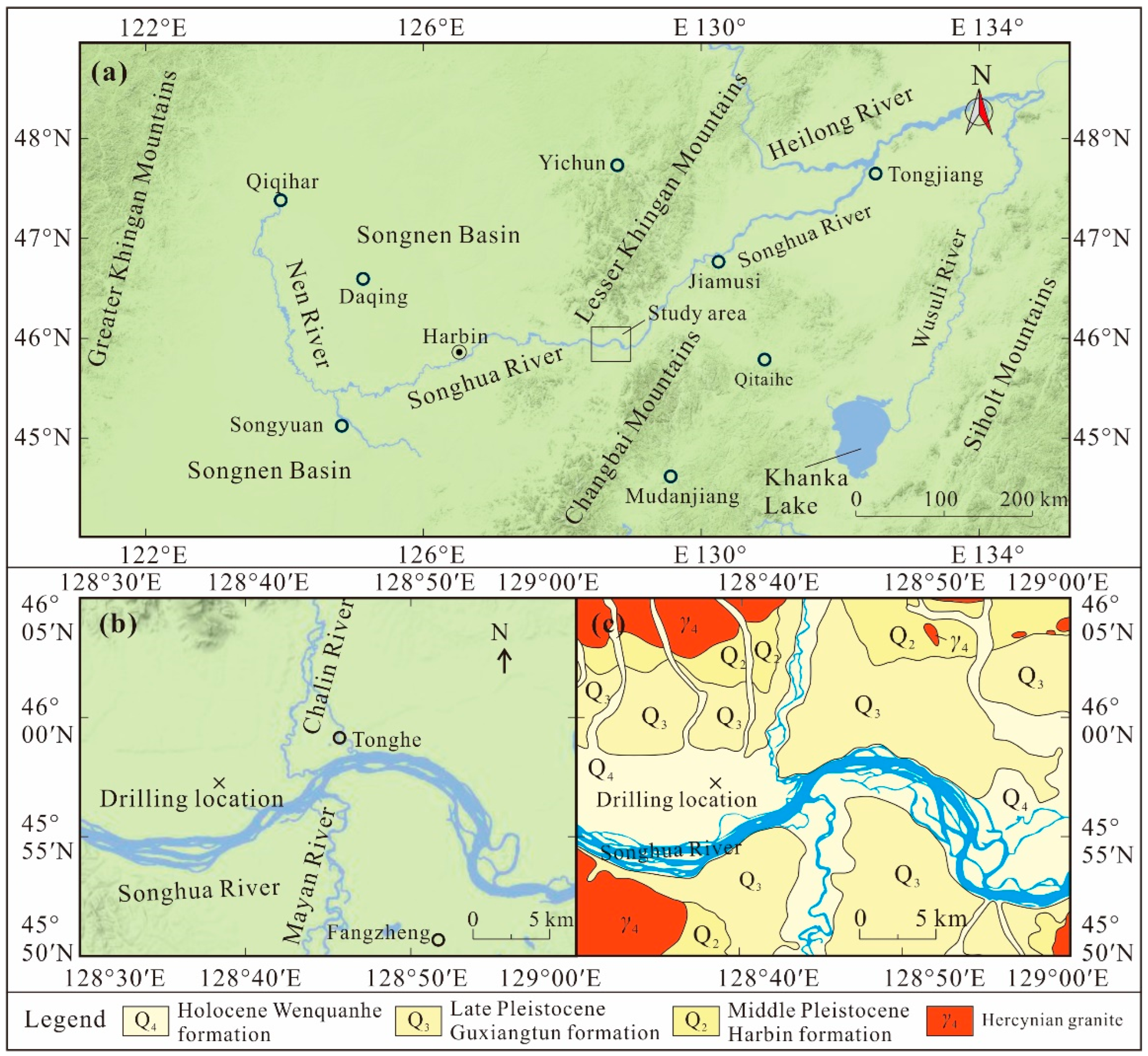
2. Geomorphologic and Geology Setting
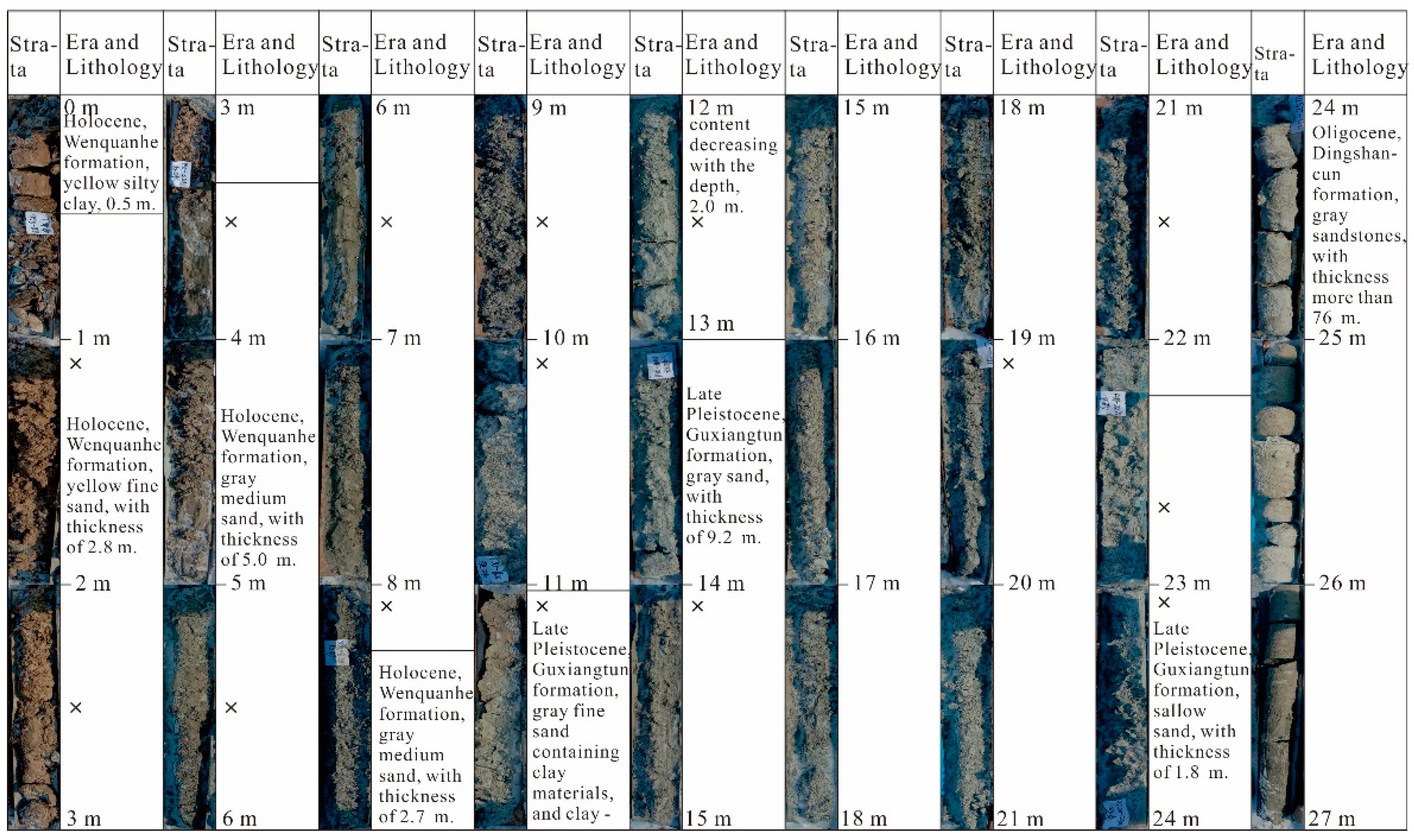
3. Sampling and Analytical Methods
4. Results
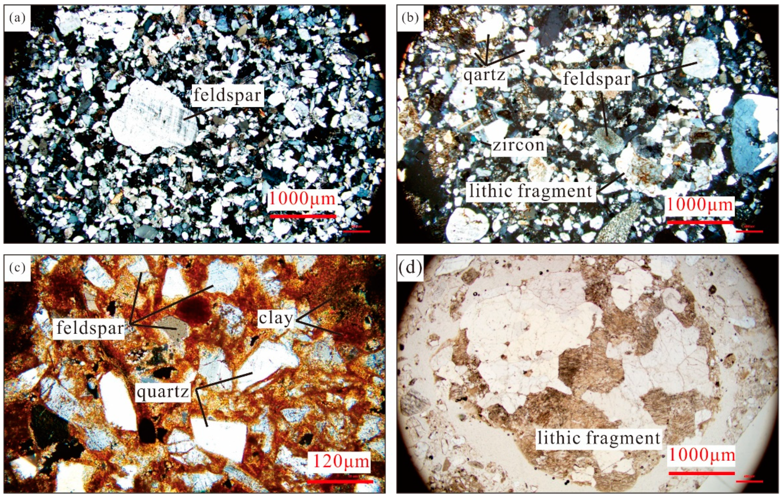
4.1. Petrography
4.2. Major Elements
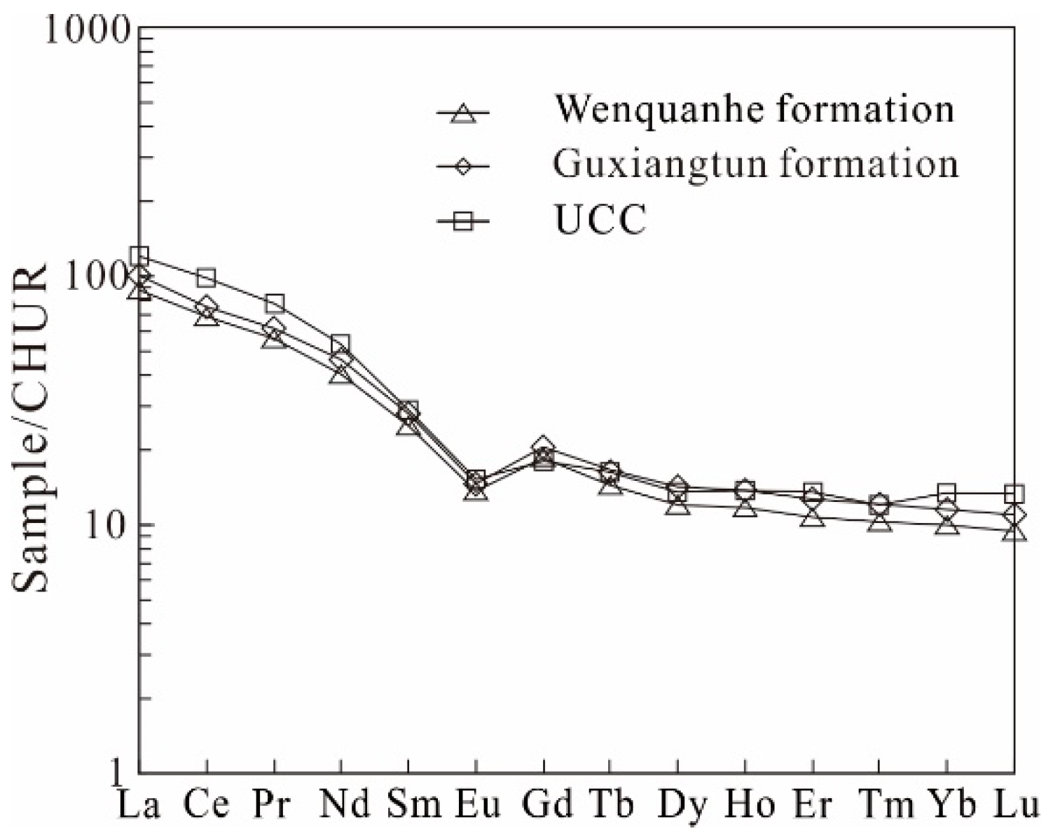
4.3. Trace Elements
5. Discussion
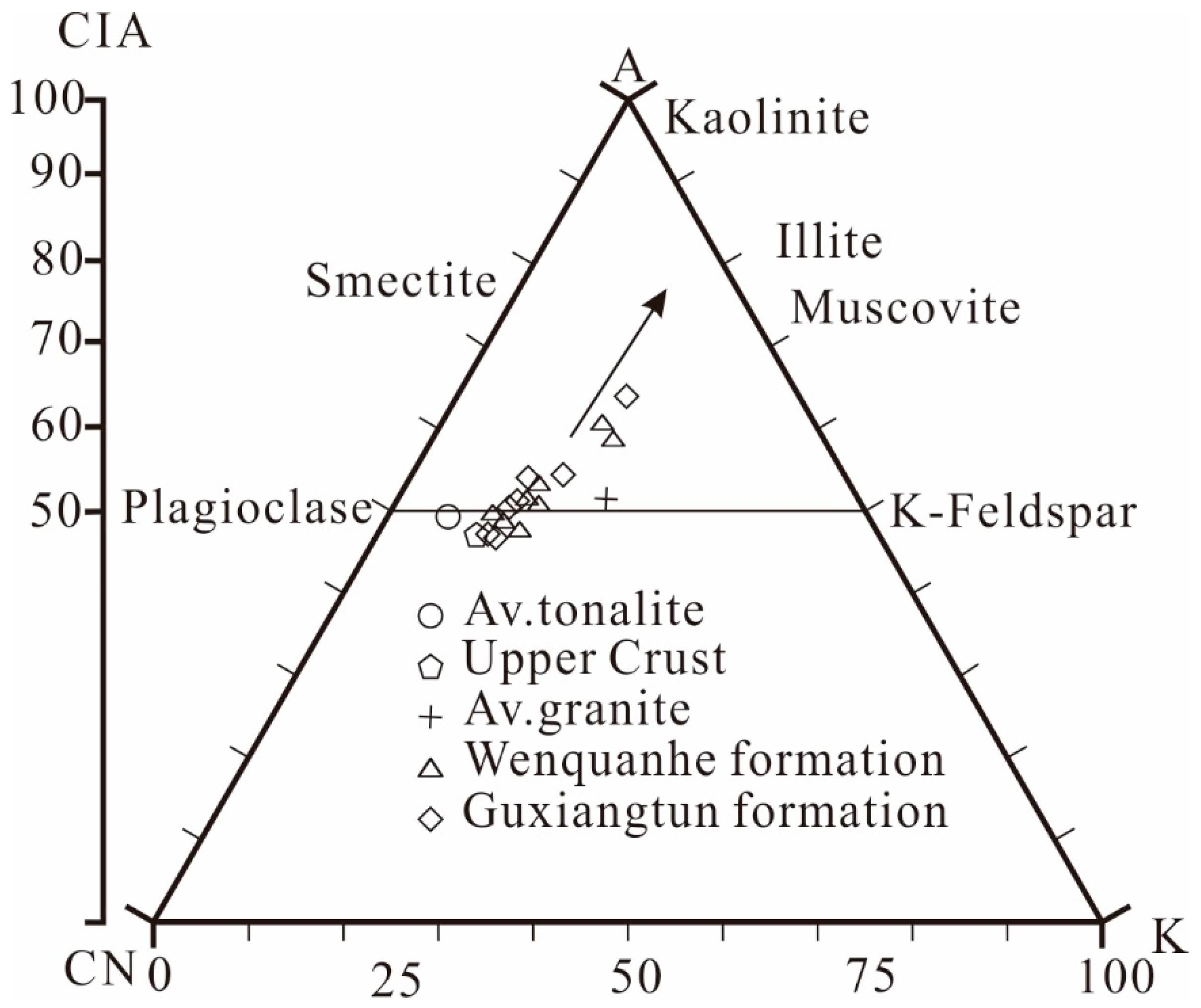
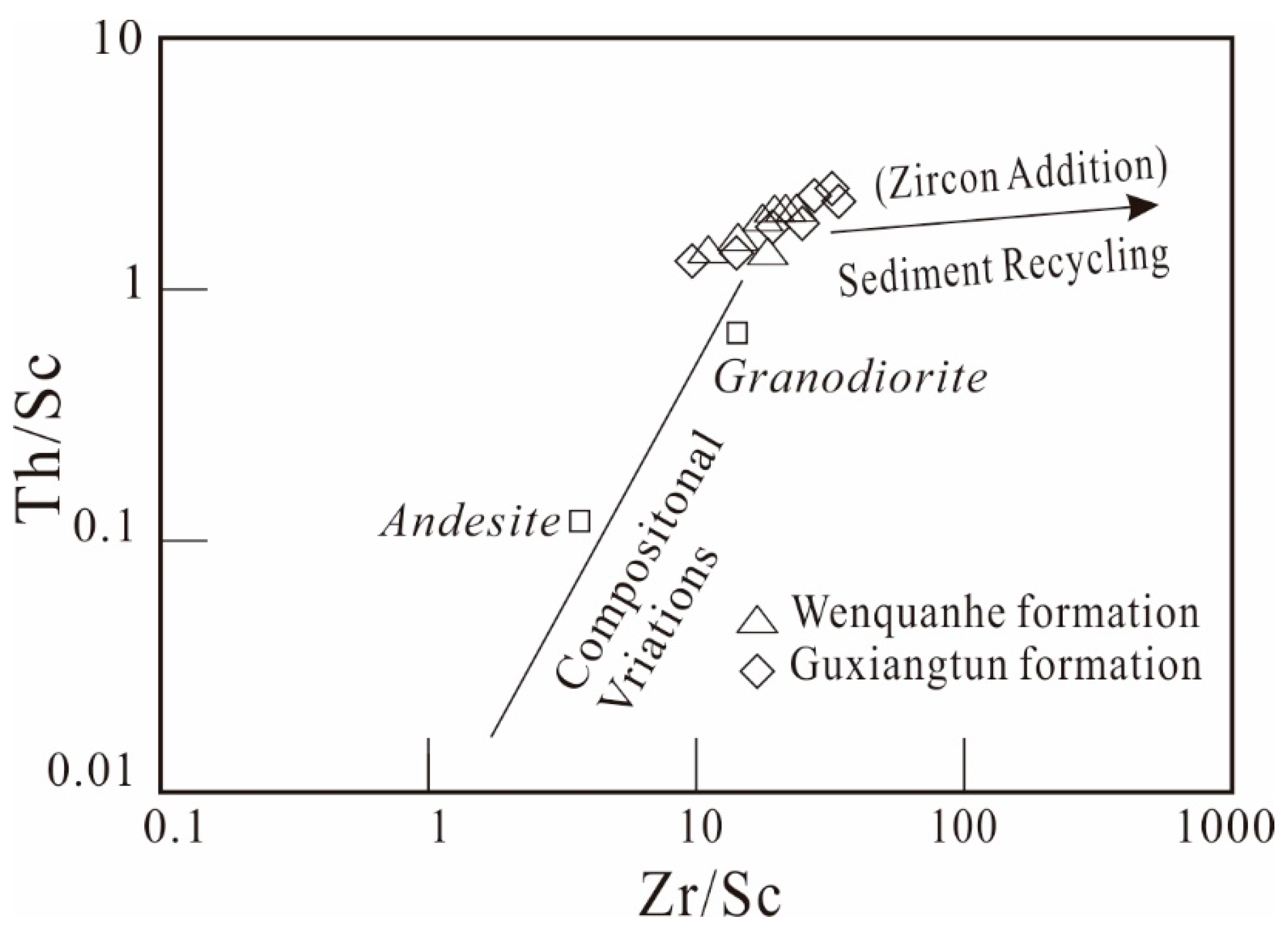
5.1. Sediment Maturity, Weathering and Sorting
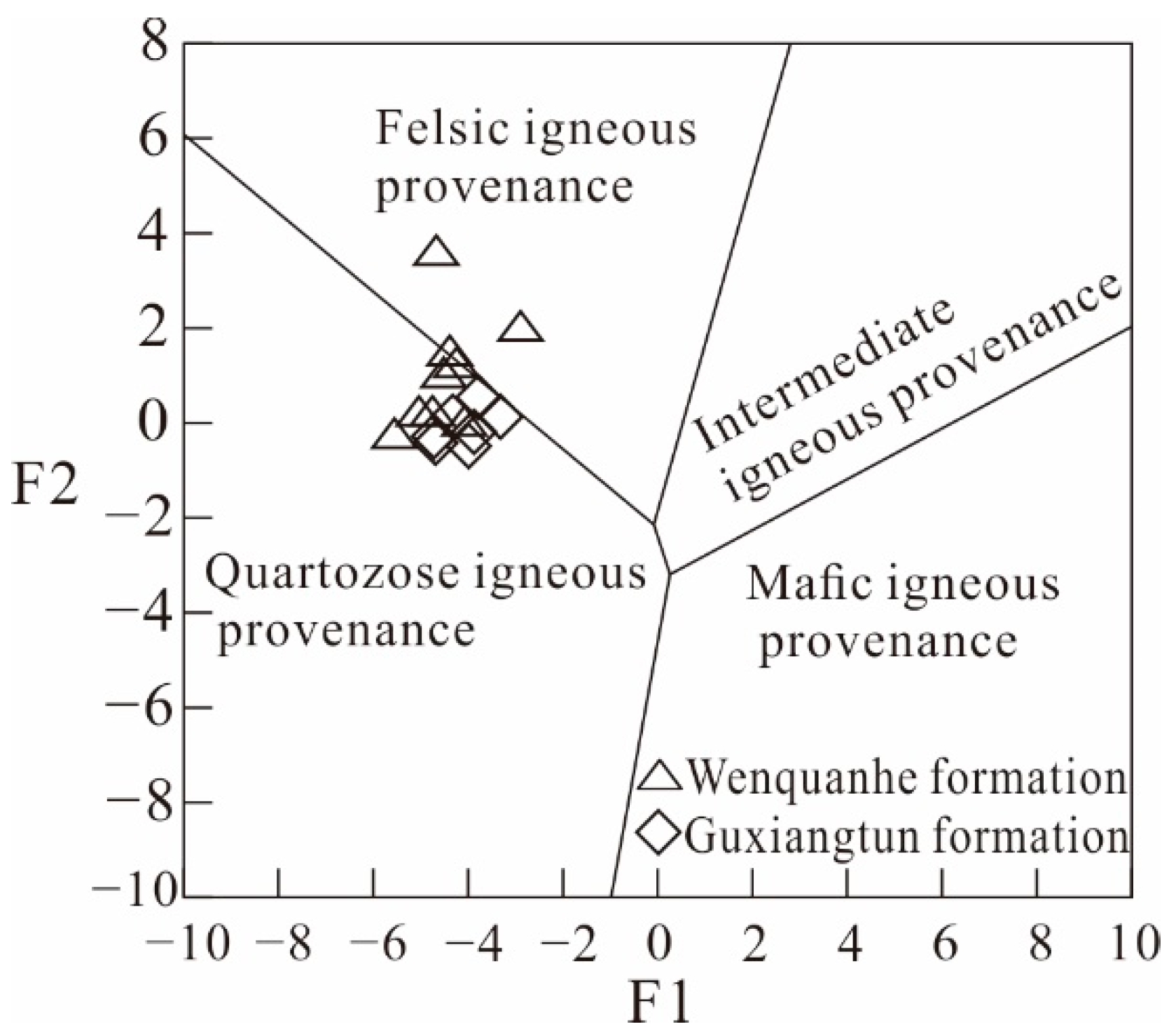
5.2. The Provenance of the Songhua River
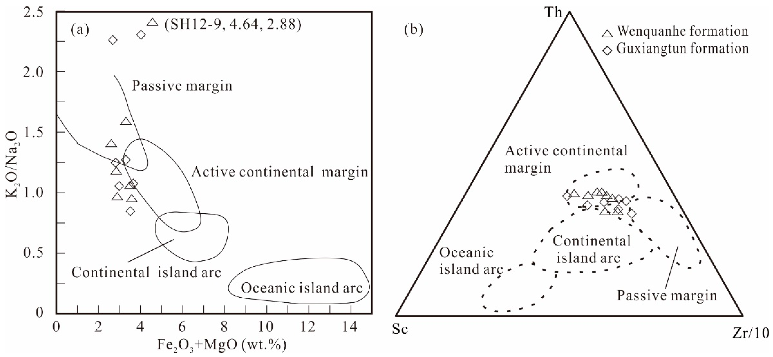
5.3. The Tectonic Setting
6. Conclusions
- (1)
- The sediments from the Guaixngtun and Wenquanhe Formations are composed mainly of quartz and feldspar, with minor mica and clay mineral, and there is no obvious distinction between them.
- (2)
- The CIA values of the sediments from the Songhua River range between 47 and 64, indicating slight chemical weathering. In addition, the sediments are slightly sorted during transport due to uniform Th/Sc and slightly variable Zr/Sc ratios.
- (3)
- Geochemical evidence proves that the provenance of Songhua River sediments is a suite of strongly differentiated rocks, part of which may undergo secondary transport. Both the Lesser Khingan Mountains and Songliao Basin provided the provenance for the Songhua River.
- (4)
- The sediments exhibit characteristics of the active continental margin mainly.
Author Contributions
Funding
Institutional Review Board Statement
Informed Consent Statement
Data Availability Statement
Acknowledgments
Conflicts of Interest
References
- Bhatia, M.R.; Crook, K.A.W. Trace element characteristics of graywackes and tectonic setting discrimination of sedimentary basins. Contrib. Mineral. Petrol. 1986, 92, 181–193. [Google Scholar] [CrossRef]
- Pandey, S.K.; Singh, A.K.; Hasnain, S.I. Grain-size distribution, morphoscopy and elemental chemistry of suspended sediments of Pindari Glacier, Kumaon Himalaya, India. Hydrol. Sci. 2002, 472, 213–226. [Google Scholar] [CrossRef] [Green Version]
- Wang, Y.; Traore, S.; Kerh, T. Monitoring event-based suspended sediment concentration by artificial neural network models. WSEAS Trans. Comput. 2008, 75, 359–368. [Google Scholar] [CrossRef]
- Bhuiyan, M.A.H.; Rahman, M.J.J.; Dampare, S.B.; Suzuki, S. Provenance, tectonics and source weathering of modern fluvial sediments of the Brahmaputra–Jamuna River, Bangladesh: Inference from geochemistry. J. Geochem. Explor. 2011, 111, 113–137. [Google Scholar] [CrossRef]
- Ishiga, H.; Dozen, K.; Sampei, Y. Geochemical constraints on marine invasion and provenance change related to the opening of the Japan Sea: An example from the Lower Miocene shales in the Hoda section, Shimane Peninsula, SW Japan. J. Asian Earth Sci. 1999, 17, 443–457. [Google Scholar] [CrossRef]
- Paikaray, S.; Banerjee, S.; Mukherji, S. Geochemistry of shales from the Paleoproterozoic to Neoproterozoic Vindhyan Supergroup: Implications on provenance, tectonics and paleoweathering. J. Asian Earth Sci. 2008, 32, 34–48. [Google Scholar] [CrossRef]
- Raza, M.; Khan, A.; Bhardwaj, V.R.; Rais, S. Geochemistry of Mesoproterozoic sedimentary rocks of upper Vindhyan Group, southeastern Rajasthan and implications for weathering history, composition and tectonic setting of continental crust in the northern part of Indian shield. J. Asian Earth Sci. 2012, 48, 160–172. [Google Scholar] [CrossRef]
- Saminpanya, S.; Duangkrayom, J.; Jintasakul, P.; Hanta, R. Petrography, mineralogy and geochemistry of Cretaceous sediment samples from western Khorat Plateau, Thailand, and considerations on their provenance. J. Asian Earth Sci. 2014, 83, 13–34. [Google Scholar] [CrossRef]
- Grimes, C.B.; Wooden, J.L.; Cheadle, M.J.; John, B.E. “Fingerprinting” tectono-magmatic provenance using trace elements in igneous zircon. Contrib. Mineral. Petrol. 2015, 17, 46. [Google Scholar] [CrossRef]
- Kassi, A.M.; Grigsby, J.D.; Khan, A.S.; Kasi, A.K. Sandstone petrology and geochemistry of the Oligocene–Early Miocene Panjgur Formation, Makran accretionary wedge, southwest Pakistan: Implications for provenance, weathering and tectonic setting. J. Asian Earth Sci. 2015, 105, 192–207. [Google Scholar] [CrossRef]
- McDonough, W.F.; Sun, S.S. The composition of the Earth. Chem. Geol. 1995, 120, 223–253. [Google Scholar] [CrossRef]
- Singh, P. Major, trace and REE geochemistry of the Ganga River sediments: Influence of provenance and sedimentary processes. Chem. Geol. 2009, 266, 251–264. [Google Scholar] [CrossRef]
- Singh, P. Geochemistry and provenance of stream sediments of the Ganga River and its major tributaries in the Himalayan region, India. Chem. Geol. 2010, 269, 220–236. [Google Scholar] [CrossRef]
- McLennan, S.M. Rare earth elements in sedimentary rocks; influence of provenance and sedimentary processes. Rev. Mineral. Geochem. 1989, 21, 169–200. [Google Scholar]
- Li, S.; Xie, Y.; Chi, Y.; Kang, C.; Sun, L.; Wu, P. Influence of provenance-river process-chemical weathering on heavy mineral composition of the Songhua River sediment. Chin. J. Geol. 2022, 57, 207–229. [Google Scholar]
- Gregory, K.J.; Park, C. Adjustment of river channel capacity downstream from a reservoir. Water Resour. Res. 1974, 10, 870–873. [Google Scholar] [CrossRef]
- Carretier, S.; Nivière, B.; Giamboni, M.; Winter, T. Do river profiles record along-stream variations of low uplift rate? J. Geophys. Res. Earth Surf. 2006, 111, 285–293. [Google Scholar] [CrossRef] [Green Version]
- Gregory, K.J. The human role in changing river channels. Geomorphology 2006, 79, 172–191. [Google Scholar] [CrossRef]
- Singh, M.; Sharma, M.; Tobschall, H.J. Weathering of the Ganga alluvial plain, northern India: Implications from fluvial geochemistry of the Gomati River. Appl. Geochem. 2005, 20, 1–21. [Google Scholar] [CrossRef]
- Zhang, X.; Dalrymple, R.W.; Yang, S.Y.; Lin, C.M.; Wang, P. Provenance of Holocene sediments in the outer part of the Paleo-Qiantang River estuary, China. Mar. Geol. 2015, 366, 1–15. [Google Scholar] [CrossRef]
- Wu, P.; Xie, Y.; Kang, C.; Chi, Y.; Wei, Z.; Wang, J.; Zhang, M.; Zhang, Y.; Liu, L. The capture of the Songhua River system in the late Early Pleistocene: Geochemical and sedimentological records. Acta Geol. Sin. 2020, 94, 3144–3160. [Google Scholar]
- Xie, Y.; Kang, C.; Chi, Y.; Wu, P.; Wei, Z.; Wang, J.; Sun, L. Reversal of the middle-upper Songhua River in the late Early Pleistocene, Northeast China. Geomorphology 2020, 369, 107373. [Google Scholar] [CrossRef]
- Sun, Z.; Jia, C. Discussion on the construction of flood storage and detention area in Songhua River Basin. Northeast Water Resour. Hydropower 2007, 25, 31–33. [Google Scholar]
- Wang, J.; Xie, Y.; Kang, C.; Chi, Y.; Wu, P.; Wei, Z.; Sun, L. The indication of the heavy mineral characteristics of the core in Harbin Huangshan to the Quaternary drainage evolution of Songhua River. Quat. Sci. 2020, 40, 79–94. [Google Scholar]
- Burean of Geology and Mineral Resources of Heilongjiang Province (BGMRHP). Regional Geology of Heilongjiang Province, 3rd ed.; Geological Publishing House: Beijing, China, 1993; pp. 1–190. [Google Scholar]
- Liu, Y.; Liu, H.C.; Li, X.H. Simultaneous and precise determination of 40 trace elements in rock samples using ICP-MS. Geochimica 1996, 25, 552–558. [Google Scholar]
- Liang, X.R.; Li, X.H.; Liu, Y.; Li, J.Y. Ablation microprobe-inductively coupled plasma mass spectrometry: A new method for rapid determination of multiple elements in rock samples. Instrum. Anal. 2000, 19, 33–36. [Google Scholar]
- Li, X.H.; Liu, Y.; Tu, X.L.; Hu, G.Q.; Zheng, W. Precise determination of chemical compositions in silicate rocks using ICP-AES and ICP-MS: A comparative study of sample digestion techniques of alkali fusion and acid dissolution. Geochimica 2002, 31, 289–294. [Google Scholar]
- Herron, M.M. Geochemical classification of terrigenous sands and shales from core or log data. J. Sediment. Petrol. 1988, 58, 820–829. [Google Scholar]
- Taylor, S.R.; McLennan, S.M. The Continental Crust: Its Composition and Evolution, 1st ed.; Blackwell: Oxford, UK, 1985; p. 312. [Google Scholar]
- Das, B.K.; Al-Mikhlafi, A.S.; Kaur, P. Geochemistry of Mansar Lake sediments, Jammu, India: Implication for source-area weathering, provenance, and tectonic setting. Asian Earth Sci. 2006, 26, 649–668. [Google Scholar] [CrossRef]
- Potter, P.E. Petrology and chemistry of modern big river sands. J. Geol. 1978, 86, 423–449. [Google Scholar] [CrossRef]
- Masuda, A.; Nakamura, N.; Tanaka, T. Fine structures of mutually normalized rare-earth patterns of chondrites. Geochim. Cosmochim. Acta 1973, 37, 239–248. [Google Scholar] [CrossRef]
- Dypvik, H.; Riber, L.; Burca, F.; Rüther, D.; Jargvoll, D.; Nagy, J.; Jochmann, M. The Paleocene–Eocene thermal maximum (PETM) in Svalbard—Clay mineral and geochemical signals. Palaeogeogr. Palaeoclimatol. Palaeoecol. 2011, 302, 156–169. [Google Scholar] [CrossRef]
- Harald, G.D. Trends and Composition—A Sedimentological-Chemical-Mineralogical Approach to Constrain the Origin of Quaternary Deposits and Landforms—From a Review to a Manual. Geosciences 2022, 12, 24. [Google Scholar]
- Roser, B.P.; Korsch, R.J. Provenance signatures of sandstone–mudstone suites determined using discriminant function analysis of major-element data. Chem. Geol. 1988, 67, 119–139. [Google Scholar] [CrossRef]
- Roser, B.P.; Ishiga, H.; Lee, H.K. Geochemistry and provenance of Cretaceous sediments from the Eusing block, Gyeongsang Basin, Korea. Mem. Geol. Soc. Jpn. 2000, 57, 155–170. [Google Scholar]
- Abedini, A.; Azizi, M.R.; Dill, H.G. Formation mechanisms of lanthanide tetrad effect in limestones: An example from Arbanos district, NW Iran. Carbonates Evaporites 2020, 35, 1. [Google Scholar] [CrossRef]
- Monecke, T.; Kempe, U.; Monecke, J.; Sala, M.; Wolf, D. Tetrad effect in rare earth element distribution patterns: A method of quantification with application to rock and mineral samples from granite-related rare metal deposits. Geochim. Cosmochim. Acta 2002, 66, 1185–1196. [Google Scholar] [CrossRef]
- McLennan, S.M.; Hemming, S.M.; McDaniel, D.K.; Hanson, G.N. Geochemical approaches to sedimentation, provenance and tectonics. Geol. Soc. Am. Spec. Pap. 1993, 284, 21–40. [Google Scholar]
- Bhatia, M.R. Plate tectonics and geocheical composition of sandstone. J. Geol. 1983, 91, 611–627. [Google Scholar] [CrossRef]
- Ge, M.; Zhang, J.; Liu, K.; Wang, M.; Li, Z. Petrogenesis of the Late Paleozoic to Mesozoic granite from the Xiao Hinggan Mountains-Zhangguangcai Mountains and its geological implications. Acta Petrol. Mineral. 2020, 39, 385–405. [Google Scholar]


| Sample | Wenquanhe Formation | Guxiangcun Formation | |||||||||||||||
|---|---|---|---|---|---|---|---|---|---|---|---|---|---|---|---|---|---|
| SH12-1 | SH12-2 | SH12-3 | SH12-4 | SH12-5 | SH12-6 | SH12-7 | SH12-8 | Mean | SH12-9 | SH12-10 | SH12-11 | SH12-12 | SH12-13 | SH12-14 | SH12-15 | Mean | |
| SiO2 | 70.25 | 69.62 | 74.31 | 75.86 | 76.43 | 74.51 | 76.79 | 77.03 | 74.4 | 67.32 | 73.78 | 76.64 | 77.37 | 75.62 | 78.17 | 77.23 | 75.16 |
| TiO2 | 0.6 | 0.6 | 0.42 | 0.41 | 0.44 | 0.47 | 0.47 | 0.41 | 0.5 | 0.66 | 0.49 | 0.41 | 0.41 | 0.38 | 0.49 | 0.41 | 0.46 |
| Al2O3 | 14.14 | 15.03 | 11.63 | 10.58 | 10.23 | 11.69 | 10.32 | 9.72 | 11.7 | 15.6 | 11.76 | 9.39 | 10.28 | 10.71 | 9.37 | 10.64 | 11.11 |
| Fe2O3(T) 1 | 2.16 | 1.87 | 2.46 | 2.11 | 2.33 | 1.71 | 2.29 | 2.18 | 2.1 | 3.34 | 2.27 | 2.43 | 1.67 | 2.52 | 1.72 | 1.93 | 2.27 |
| MnO | 0.08 | 0.08 | 0.07 | 0.06 | 0.08 | 0.08 | 0.07 | 0.07 | 0.1 | 0.1 | 0.09 | 0.08 | 0.08 | 0.06 | 0.07 | 0.06 | 0.08 |
| MgO | 1.87 | 0.82 | 1.06 | 0.88 | 1.23 | 1.14 | 1.19 | 1.13 | 1.2 | 1.3 | 1.11 | 1.15 | 0.87 | 0.99 | 1.18 | 0.94 | 1.08 |
| CaO | 1.43 | 1.49 | 2.14 | 1.43 | 2.38 | 2.24 | 1.45 | 2.22 | 1.8 | 1.16 | 1.82 | 2.37 | 1.92 | 2.19 | 2.47 | 1.91 | 1.98 |
| Na2O | 1.57 | 2.09 | 3.23 | 2.75 | 2.26 | 2.39 | 2.51 | 2.19 | 2.4 | 1.4 | 1.85 | 2.37 | 1.78 | 2.28 | 2.24 | 1.97 | 1.98 |
| K2O | 3.63 | 4.74 | 2.74 | 2.91 | 2.35 | 2.97 | 2.63 | 2.79 | 3.1 | 4.03 | 2.95 | 2.31 | 2.52 | 2.44 | 2.16 | 2.32 | 2.68 |
| P2O5 | 0.14 | 0.12 | 0.14 | 0.21 | 0.08 | 0.13 | 0.12 | 0.09 | 0.1 | 0.13 | 0.16 | 0.17 | 0.18 | 0.13 | 0.09 | 0.08 | 0.13 |
| LOI | 3.75 | 3.75 | 1.61 | 2.3 | 1.72 | 2.13 | 1.89 | 2.12 | 2.4 | 4.6 | 3.08 | 2.28 | 2.37 | 2.46 | 1.71 | 2.42 | 2.70 |
| Total | 99.61 | 99.19 | 99.81 | 99.5 | 99.53 | 99.46 | 99.73 | 99.95 | 99.60 | 99.65 | 99.36 | 99.6 | 99.45 | 99.78 | 99.67 | 99.91 | 99.63 |
| CIA | 61 | 57 | 49 | 51 | 49 | 51 | 52 | 48 | 64 | 55 | 47 | 53 | 51 | 47 | 53 | 52.82 | |
| SiO2/Al2O3 | 4.97 | 4.63 | 6.39 | 7.17 | 7.47 | 6.37 | 7.44 | 7.92 | 6.55 | 4.32 | 6.27 | 8.16 | 7.53 | 7.06 | 8.34 | 7.26 | 6.77 |
| Na2O/K2O | 0.43 | 0.44 | 1.18 | 0.95 | 0.96 | 0.80 | 0.95 | 0.78 | 0.81 | 0.35 | 0.63 | 1.03 | 0.71 | 0.93 | 1.04 | 0.85 | 0.74 |
| K2O/Na2O | 2.31 | 2.27 | 0.85 | 1.06 | 1.04 | 1.24 | 1.05 | 1.27 | 2.88 | 1.59 | 0.97 | 1.42 | 1.07 | 0.96 | 1.18 | 1.35 | |
| Fe2O3/K2O | 0.60 | 0.39 | 0.90 | 0.73 | 0.99 | 0.58 | 0.87 | 0.78 | 0.69 | 0.83 | 0.77 | 1.05 | 0.66 | 1.03 | 0.80 | 0.83 | 0.85 |
| Sc | 13.4 | 13.2 | 8.78 | 5.92 | 9.27 | 11.64 | 8.31 | 8.21 | 9.8 | 16.2 | 10.7 | 7.85 | 8.21 | 7.23 | 8.74 | 10.38 | 9.90 |
| V | 104.6 | 94.4 | 62.3 | 45.7 | 67.1 | 66.2 | 61.9 | 62.1 | 70.5 | 127.2 | 84 | 64.3 | 60.6 | 52.1 | 59.7 | 52.2 | 71.44 |
| Cr | 31.4 | 29.7 | 19.1 | 23.6 | 31.7 | 60.1 | 26.2 | 37.4 | 32.4 | 29 | 36.5 | 35.2 | 45.2 | 38.7 | 47.1 | 34.5 | 38.0 |
| Co | 9.05 | 10.15 | 10.39 | 8.31 | 9.65 | 8.9 | 10.27 | 9.38 | 9.5 | 8.59 | 8.17 | 8.72 | 7.19 | 10.48 | 9.37 | 9.92 | 8.9 |
| Ni | 21.4 | 19.9 | 14.3 | 20.8 | 19.6 | 21.2 | 19.3 | 31.5 | 21.0 | 17.7 | 23.4 | 31.2 | 21.4 | 15.2 | 24.9 | 25.1 | 22.7 |
| Zn | 69.8 | 70.9 | 35.7 | 40.3 | 42.2 | 57.1 | 56.9 | 65.6 | 54.8 | 89.4 | 62.47 | 43.7 | 54.3 | 41.7 | 40.8 | 38.9 | 53.0 |
| Rb | 141.1 | 135.8 | 97.3 | 111.4 | 102.5 | 99.8 | 102.7 | 100.5 | 111.4 | 171.6 | 127.2 | 102.3 | 107.6 | 98.1 | 90.2 | 97.8 | 113.5 |
| Sr | 128 | 109.4 | 189 | 199 | 172 | 166 | 152 | 154 | 158.7 | 115 | 161 | 191 | 178 | 179 | 154 | 186 | 166.3 |
| Y | 28.4 | 24.4 | 21.5 | 15.2 | 26.1 | 23.6 | 22.4 | 27.1 | 23.6 | 27.9 | 25.1 | 25.7 | 21.8 | 19.3 | 26.6 | 18.4 | 23.5 |
| Zr | 191 | 146 | 171 | 104 | 230 | 214 | 178 | 194 | 178.5 | 156 | 205 | 250 | 208 | 198 | 295 | 146 | 208.3 |
| Nb | 9.51 | 10.35 | 5.78 | 7.49 | 8.04 | 6.91 | 4.19 | 8.44 | 7.6 | 11.33 | 7.87 | 6.08 | 6.21 | 4.72 | 4.17 | 5.2 | 6.5 |
| Cs | 7.62 | 7.12 | 4.59 | 4.48 | 2.01 | 2.59 | 3.21 | 5.82 | 4.7 | 13.5 | 7.7 | 4.15 | 5.45 | 5.18 | 5.97 | 5.23 | 6.7 |
| Ba | 487 | 495 | 289 | 237 | 233 | 256 | 259 | 286 | 317.8 | 560 | 340 | 207 | 253 | 286 | 213 | 225 | 297.7 |
| La | 40.5 | 39.5 | 27.5 | 25.9 | 28.6 | 27.5 | 23.4 | 17.3 | 28.8 | 41.3 | 33.2 | 20.1 | 28.2 | 23.5 | 25.8 | 36.4 | 29.8 |
| Ce | 75 | 78 | 52 | 52.3 | 57 | 48.6 | 53 | 38 | 56.7 | 92 | 62 | 43 | 47 | 45 | 56 | 73.9 | 59.8 |
| Pr | 8.63 | 8.81 | 6.82 | 6.33 | 5.65 | 5.55 | 6.31 | 4.51 | 6.6 | 10.8 | 6.47 | 4.98 | 5.12 | 5.08 | 6.12 | 8.53 | 6.7 |
| Nd | 30.2 | 26.8 | 27.7 | 21.7 | 27.2 | 24.7 | 21.3 | 16.9 | 24.6 | 34.1 | 29.3 | 19.7 | 21.7 | 23.8 | 21.5 | 36.3 | 26.6 |
| Sm | 5.88 | 6.18 | 4.15 | 3.65 | 5.17 | 3.73 | 4.59 | 3.21 | 4.6 | 6.98 | 4.76 | 4.17 | 4.32 | 5.07 | 4.07 | 5.94 | 5.0 |
| Eu | 1.35 | 1.23 | 0.96 | 0.88 | 1.26 | 0.82 | 0.91 | 0.71 | 1.0 | 1.41 | 1.04 | 1.05 | 0.85 | 1.08 | 0.7 | 1.21 | 1.0 |
| Gd | 6.71 | 5.8 | 4.31 | 3.71 | 5.24 | 4.95 | 3.75 | 4.41 | 4.9 | 6.82 | 5.74 | 5.32 | 3.89 | 4.18 | 4.47 | 5.13 | 5.1 |
| Tb | 0.93 | 0.91 | 0.76 | 0.56 | 0.55 | 0.57 | 0.62 | 0.63 | 0.7 | 0.99 | 0.86 | 0.68 | 0.6 | 0.61 | 0.85 | 0.76 | 0.8 |
| Dy | 5.26 | 4.89 | 3.73 | 3.54 | 3.54 | 4.03 | 3.63 | 3.9 | 4.1 | 5.62 | 5.51 | 3.98 | 3.74 | 3.86 | 4.6 | 4.05 | 4.5 |
| Ho | 0.93 | 0.94 | 0.86 | 0.89 | 0.85 | 0.91 | 0.81 | 0.85 | 0.9 | 1.07 | 1.13 | 0.94 | 0.85 | 0.88 | 0.94 | 0.91 | 1.0 |
| Er | 3.06 | 2.72 | 2.2 | 1.94 | 2.88 | 2.03 | 2.15 | 1.97 | 2.4 | 3.01 | 3.16 | 2.34 | 2.54 | 2.38 | 2.89 | 2.44 | 2.7 |
| Tm | 0.4 | 0.41 | 0.4 | 0.31 | 0.36 | 0.32 | 0.31 | 0.31 | 0.4 | 0.45 | 0.44 | 0.35 | 0.39 | 0.36 | 0.37 | 0.38 | 0.4 |
| Yb | 2.79 | 2.63 | 1.98 | 1.81 | 2.1 | 1.93 | 1.96 | 1.84 | 2.1 | 2.73 | 2.62 | 2.06 | 2.08 | 2.26 | 2.51 | 2.37 | 2.4 |
| Lu | 0.39 | 0.36 | 0.33 | 0.27 | 0.28 | 0.28 | 0.31 | 0.26 | 0.3 | 0.41 | 0.39 | 0.32 | 0.33 | 0.31 | 0.35 | 0.35 | 0.4 |
| Hf | 5.34 | 3.42 | 7.16 | 4.23 | 8.14 | 6.34 | 6.02 | 8.4 | 6.1 | 4.35 | 5.66 | 6.83 | 5.81 | 8.36 | 10.98 | 7.11 | 7.0 |
| Ta | 0.93 | 0.96 | 0.96 | 0.74 | 0.8 | 0.66 | 0.83 | 1.05 | 0.9 | 1.02 | 0.89 | 0.88 | 0.76 | 0.6 | 1.04 | 0.77 | 0.9 |
| W | 2.22 | 2.83 | 1.1 | 2.35 | 2.01 | 2.16 | 1.08 | 1.77 | 1.9 | 2.5 | 1.66 | 1.04 | 1.43 | 1.68 | 1.2 | 2.35 | 1.7 |
| Pb | 28.5 | 27.5 | 21.5 | 18 | 12.2 | 19.6 | 23.9 | 18 | 21.2 | 64.9 | 36.7 | 22.5 | 22.7 | 11 | 18.3 | 12.3 | 26.9 |
| Th | 21.4 | 18.8 | 18.2 | 11.3 | 17.1 | 16.3 | 17.3 | 17.6 | 17.3 | 20.7 | 18.7 | 19.6 | 15.7 | 16.9 | 19.4 | 14.3 | 17.9 |
| U | 2.85 | 2.64 | 3.06 | 1.47 | 2.15 | 3.08 | 1.97 | 3.05 | 2.5 | 3 | 2.54 | 2.76 | 1.85 | 1.2 | 2.27 | 1.79 | 2.2 |
| ∑REE | 182 | 179 | 134 | 124 | 141 | 126 | 123 | 95 | 208 | 157 | 109 | 122 | 118 | 131 | 179 | 146 | |
| LaN/YbN | 9.6 | 9.9 | 9.2 | 9.4 | 9.0 | 9.4 | 7.9 | 6.2 | 10.0 | 8.4 | 6.4 | 9.0 | 6.9 | 6.8 | 10.1 | 8.3 | |
| Ce/Ce* 2 | 0.9 | 1.0 | 0.9 | 1.0 | 1.0 | 0.9 | 1.0 | 1.0 | 1.0 | 1.0 | 1.0 | 1.0 | 0.9 | 1.0 | 1.0 | 1.0 | 1.0 |
| Eu/Eu* | 0.67 | 0.64 | 0.70 | 0.74 | 0.75 | 0.59 | 0.68 | 0.58 | 0.63 | 0.62 | 0.69 | 0.64 | 0.73 | 0.51 | 0.68 | 0.64 | |
| CeN/YbN | 6.9 | 7.6 | 6.7 | 7.4 | 6.9 | 6.4 | 6.9 | 5.3 | 6.8 | 8.6 | 6.1 | 5.3 | 5.8 | 5.1 | 5.7 | 8.0 | 6.4 |
| CeN/SmN | 3.0 | 3.0 | 3.0 | 3.4 | 2.6 | 3.1 | 2.7 | 2.8 | 2.9 | 3.1 | 3.1 | 2.4 | 2.6 | 2.1 | 3.2 | 2.9 | 2.8 |
| GdN/YbN | 1.9 | 1.8 | 1.7 | 1.6 | 2.0 | 2.1 | 1.5 | 1.9 | 1.8 | 2.0 | 1.8 | 2.1 | 1.5 | 1.5 | 1.4 | 1.7 | 1.7 |
| ∑LREE | 161.6 | 160.5 | 119.1 | 110.8 | 124.9 | 110.9 | 109.5 | 80.6 | 122.2 | 186.6 | 136.8 | 93.0 | 107.2 | 103.5 | 114.2 | 162.3 | 129.1 |
| ∑HREE | 20.5 | 18.7 | 14.6 | 13.0 | 15.8 | 15.0 | 13.5 | 14.2 | 15.7 | 21.1 | 19.9 | 16.0 | 14.4 | 14.8 | 17.0 | 16.4 | 17.1 |
| ∑LREE/∑HREE | 7.9 | 8.6 | 8.2 | 8.5 | 7.9 | 7.4 | 8.1 | 5.7 | 8.8 | 6.9 | 5.8 | 7.4 | 7.0 | 6.7 | 9.9 | 7.6 | |
| K/Rb | 213.5 | 289.6 | 233.7 | 216.8 | 190.2 | 246.9 | 212.5 | 230.4 | 230.6 | 194.9 | 192.4 | 187.4 | 194.3 | 206.4 | 198.7 | 196.8 | 195.5 |
| Th/U | 7.5 | 7.1 | 5.9 | 7.7 | 8.0 | 5.3 | 8.8 | 5.8 | 6.8 | 6.9 | 7.4 | 7.1 | 8.5 | 14.1 | 8.5 | 8.0 | 8.1 |
| Th/Sc | 1.6 | 1.4 | 2.1 | 1.9 | 1.8 | 1.4 | 2.1 | 2.1 | 1.8 | 1.3 | 1.7 | 2.5 | 1.9 | 2.3 | 2.2 | 1.4 | 1.8 |
| Zr/Sc | 14.3 | 11.1 | 19.5 | 17.6 | 24.8 | 18.4 | 21.4 | 23.6 | 18.1 | 9.6 | 19.2 | 31.8 | 25.3 | 27.4 | 33.8 | 14.1 | 21.0 |
| La/Th | 1.9 | 2.1 | 1.5 | 2.3 | 1.7 | 1.7 | 1.4 | 1.0 | 1.7 | 2.0 | 1.8 | 1.0 | 1.8 | 1.4 | 1.3 | 2.5 | 1.7 |
| La/Sc | 3.0 | 3.0 | 3.1 | 4.4 | 3.1 | 2.4 | 2.8 | 2.1 | 2.9 | 2.5 | 3.1 | 2.6 | 3.4 | 3.3 | 3.0 | 3.5 | 3.0 |
| Sc/Th | 0.6 | 0.7 | 0.5 | 0.5 | 0.5 | 0.7 | 0.5 | 0.5 | 0.6 | 0.8 | 0.6 | 0.4 | 0.5 | 0.4 | 0.5 | 0.7 | 0.6 |
| T1 | 0.06 | 0.16 | 0.07 | 0.11 | 0.10 | 0.11 | 0.17 | 0.09 | 0.11 | 0.20 | 0.09 | 0.04 | 0.11 | 0.09 | 0.12 | 0.02 | 0.10 |
| T2 | 0.03 | 0.03 | 0.11 | 0.15 | 0.27 | 0.22 | 0.06 | 0.11 | 0.12 | 0.04 | 0.06 | 0.19 | 0.09 | 0.12 | 0.10 | 0.11 | 0.10 |
| T3 | 0.09 | 0.06 | 0.13 | 0.04 | 0.05 | 0.04 | 0.05 | 0.05 | 0.06 | 0.01 | 0.04 | 0.03 | 0.06 | 0.06 | 0.09 | 0.03 | 0.04 |
Publisher’s Note: MDPI stays neutral with regard to jurisdictional claims in published maps and institutional affiliations. |
© 2022 by the authors. Licensee MDPI, Basel, Switzerland. This article is an open access article distributed under the terms and conditions of the Creative Commons Attribution (CC BY) license (https://creativecommons.org/licenses/by/4.0/).
Share and Cite
Kan, W.; Yang, Z.; Yu, L.; Sun, M. Provenance and Tectonic Setting of Formation of Quaternary Sedimentary Successions from the Songhua River, Northeast China. Appl. Sci. 2022, 12, 7356. https://doi.org/10.3390/app12157356
Kan W, Yang Z, Yu L, Sun M. Provenance and Tectonic Setting of Formation of Quaternary Sedimentary Successions from the Songhua River, Northeast China. Applied Sciences. 2022; 12(15):7356. https://doi.org/10.3390/app12157356
Chicago/Turabian StyleKan, Wenguang, Zailin Yang, Liangliang Yu, and Menghan Sun. 2022. "Provenance and Tectonic Setting of Formation of Quaternary Sedimentary Successions from the Songhua River, Northeast China" Applied Sciences 12, no. 15: 7356. https://doi.org/10.3390/app12157356
APA StyleKan, W., Yang, Z., Yu, L., & Sun, M. (2022). Provenance and Tectonic Setting of Formation of Quaternary Sedimentary Successions from the Songhua River, Northeast China. Applied Sciences, 12(15), 7356. https://doi.org/10.3390/app12157356