Abstract
San Basilio basin in Baja California Sur (Mexico) exhibits distinct styles of volcanism that interrupted phases of normal sedimentation correlated with the Zanclean Stage (Lower Pliocene). Sea cliffs around a 4-km2 bay opening onto the Gulf of California are dominated by rhyolite, mudstone, sandstone, and limestone. Volcanism associated with re-sedimented hyaloclastite is regionally uncommon and the goal was to investigate interactions between volcanic events and intervals of stability represented by fossil-rich strata. Methods of study involved a combination of microfossil and macrofossil analyses. Relating the basin’s faults to Pliocene development in the greater Gulf of California was a secondary goal. Microfossils Bolivina bicostata and B. interjuncta recovered from mudstone indicate an initial water column of 150 m. An abrupt hydromagmatic explosion ruptured the mudstone cover, followed by banded rhyolite flows inter-bedded with sandstone. Outlying limestone beds with the index fossil Clypeaster bowersi are separated from rhyolite by conglomerate eroded under intertidal conditions. A renewed phase of activity saw eruption of smaller volcanoes in the basin center semi-contemporaneous with pecten limestone deposited on unstable slopes. Normal faults conform to a pattern of extensional rifting in the proto-gulf, followed by cross-cutting faults indicating the onset of transtensional tectonics beginning about 3.5 Ma.
1. Introduction
Examples of volcanic edifices with associated marine sedimentary deposits are rare from within the Gulf of California or along the adjacent peninsular Baja California shore. Forty named islands in the Gulf of California entail some component of igneous rocks, mostly associated with block-faults and the uplift of basement Cretaceous granodiorite or surface flows of Miocene andesite [1]. Among the many gulf islands, however, a few exhibit volcano superstructures. Isla San Luis is a small island (4.5 km2) in the upper gulf region that features a large, half-eroded volcanic crater and a pair of intact rhyolite domes [2]. High-energy hydromagmatic eruptions from the volcano’s earliest stage are regarded as Holocene in age. In the central gulf region, Isla Tortuga (11.4 km2) is a basaltic shield volcano that retains a central crater [3]. A third example is Isla Coronados (7.5 km2), which projects the classic shape of a stratovolcano covering 70% of the island with andesite flows. The youngest of these is about 160,000 years old [4]. In contrast to San Luis and Tortuga, Isla Coronados is notable for extensive fossil deposits that include late Pleistocene coral reefs on the volcano’s south flank [5]. Fossil deposits on San Luis and Tortuga are slim to non-existent.
Larger islands in the Gulf of California reveal paleoshores marked by well-defined unconformities between Pliocene limestone and older igneous rocks [6]. Variations in intertidal to shallow-subtidal limestone deposits are found in relation to such unconformities, but no scenario previously described for fossil beds within the Gulf of California is connected to a Pliocene volcano that was active at the time. Evidence in support of contemporaneous development would include physical proximity between fossil beds and a discernable volcanic structure, as well as possible interruptions by lava flows or ash falls.
This paper is an outgrowth of geological mapping and detailed stratigraphic logs regarding the Pliocene to Pleistocene history of landscape development in the San Basilio basin on the gulf shores of Baja California Sur, Mexico. Located north of the greater Cerro Mencenares volcanic complex [7], heretofore this scenic but remote area has received little attention. Our several goals are inter-related in design in order to: (1) show the extent of effusive volcanism associated with rhyolite domes, (2) sample microfossil foraminiferal content gauging the paleobathymetry of buried volcanics, (3) describe late-stage carbonate facies formed by Pliocene macro-faunas on the periphery of steep-sided volcanic islets and other rocky shorelines, as well as (4) survey the emplacement of faults related to the tectonic evolution of the adjacent Pliocene Gulf of California. Comparisons are made with carbonate deposits from volcanic islands that were contemporaneously active elsewhere in other parts of the world, particularly in open oceanic settings.
2. Geographical and Geological Setting
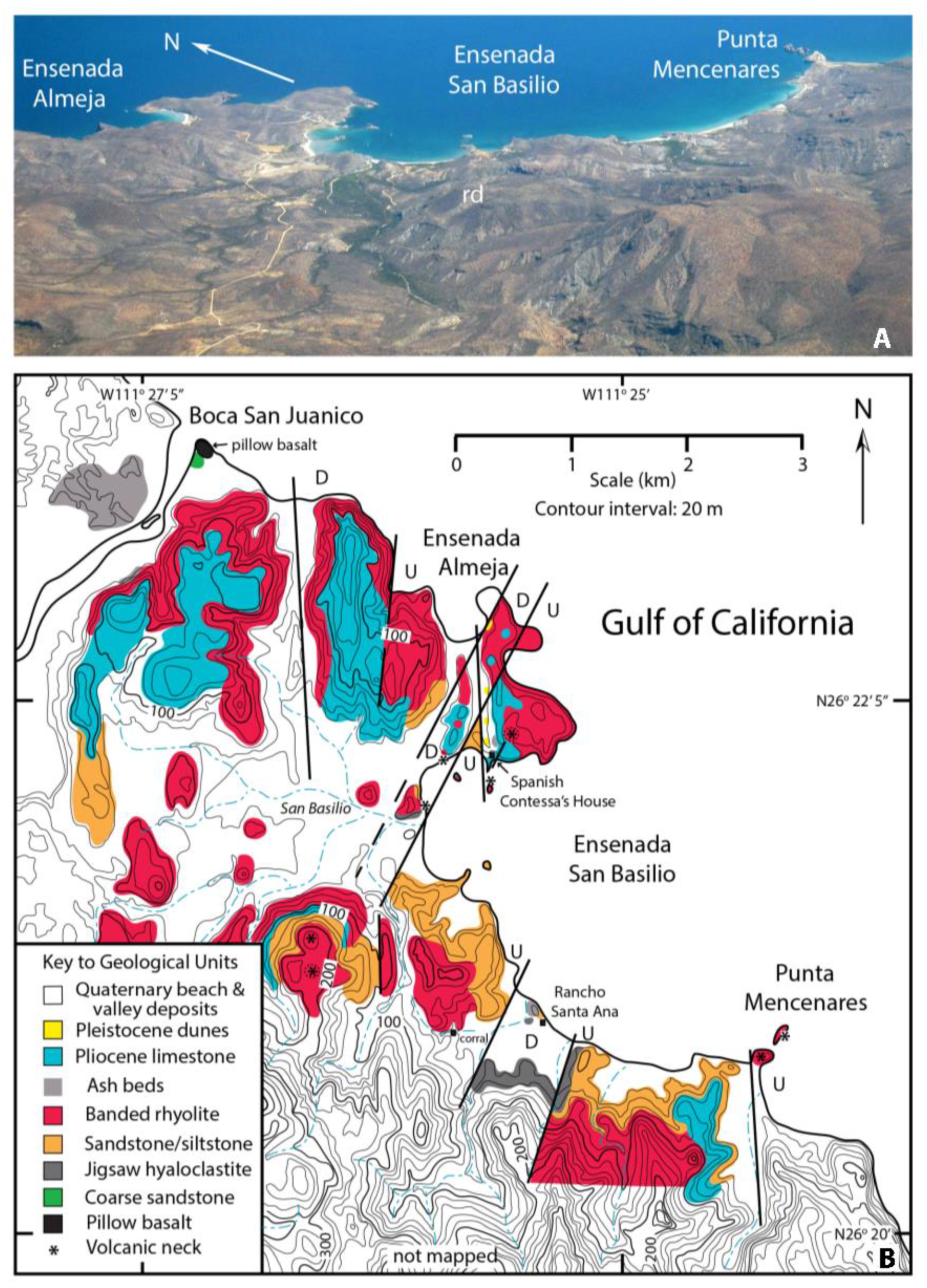
Located 30 km north of Loreto by sea along the Gulf of California (Figure 1A), the San Basilio embayment is surrounded by lands that occupy approximately 25 km2 on the north side of the Cerro Mencenares volcanic complex with its commanding shield rising more than 600 m above sea level (Figure 1B). The region can be reached by boat from Loreto or by land on secondary ranch roads east from Mexican Highway 1. The main bay opens to the southeast into the Gulf of California. It has a coastline ringed by steep rocky bluffs interspersed with sand beaches that collectively trace through an arc of 6 km. Jagged spires of rhyolite are distinctive features both at the coast, most notably at Punta Mencenares, as well as rising through the water within the bay. These reach heights typically four to five meters above the water line. A smaller bay called Ensenada Almeja, opens northward onto the Gulf of California below the outlet of the San Juanico arroyo (Figure 1B). It is framed by massive rhyolite cliffs on opposite shores, but terminates at a wide sand beach. At both ends of the beach, canyons with north-south orientations cross inland toward the large embayment to the south. The central region is heavily dissected by tributaries that converge as arroyos feeding into the San Basilio estuary on Ensenada San Basilio.
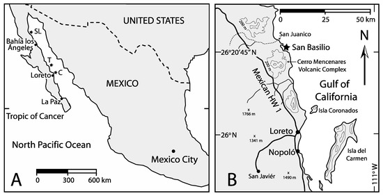
Figure 1.
Regional and local maps: (A) Mexico and the Baja California peninsula, showing sites where volcano superstructures are preserved as islands in the Gulf of California (SL = Isla San Luis; T = Isla Tortuga; C = Isla Coronados), (B) Eastern shore of Baja California Sur between Nopoló and San Juanico, showing the location of San Basilo (star).
Previously published sources on the geology of the San Basilio area are few and incomplete. The Cerro Mencenares volcanic complex (Figure 1B) is the primary focus in the most detailed study by Bigioggero et al. in 1988 [7]. Geologic maps that accompany that study [7] (Figure 2 and Figure 3 therein) extend to San Basilio, where volcanics are assigned to an older Pliocene unit shown as the San Juanico. The treatment of sedimentary rocks is inconsistent, because those mapped at a smaller scale are shown as limestone in the San Basilio basin [7] (Figure 2, therein), whereas the same areas portrayed in a more detailed map [7] (Figure 3, therein) are identified as sandstone. More than a dozen late-stage dome structures and related vents are attributed to a younger Pliocene unit shown as the San Basilio-San Juan. Rhyolitic domes in the peripheral San Basilio basin are generalized without showing eruptive vents. Likewise, a series of north-south oriented faults are mapped across Cerro Mencenares, but none extend into the San Basilio area. Data from detailed stratigraphic logs (including sedimentary rocks) are incorporated into the Cerro Mencenares study [7], but those sections are restricted to the south and more distal flank of the volcanic complex 15 km away from San Basilio.
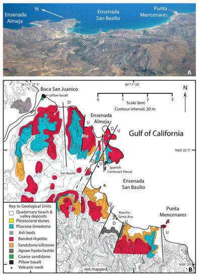
Figure 2.
San Basilio topography: (A) Aerial photo covering 25-km2 between Punta Mencenares and Ensenada Almeja, rd = rhyolite dome, (B) Geologic map.
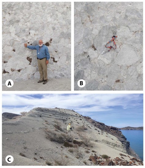
Figure 3.
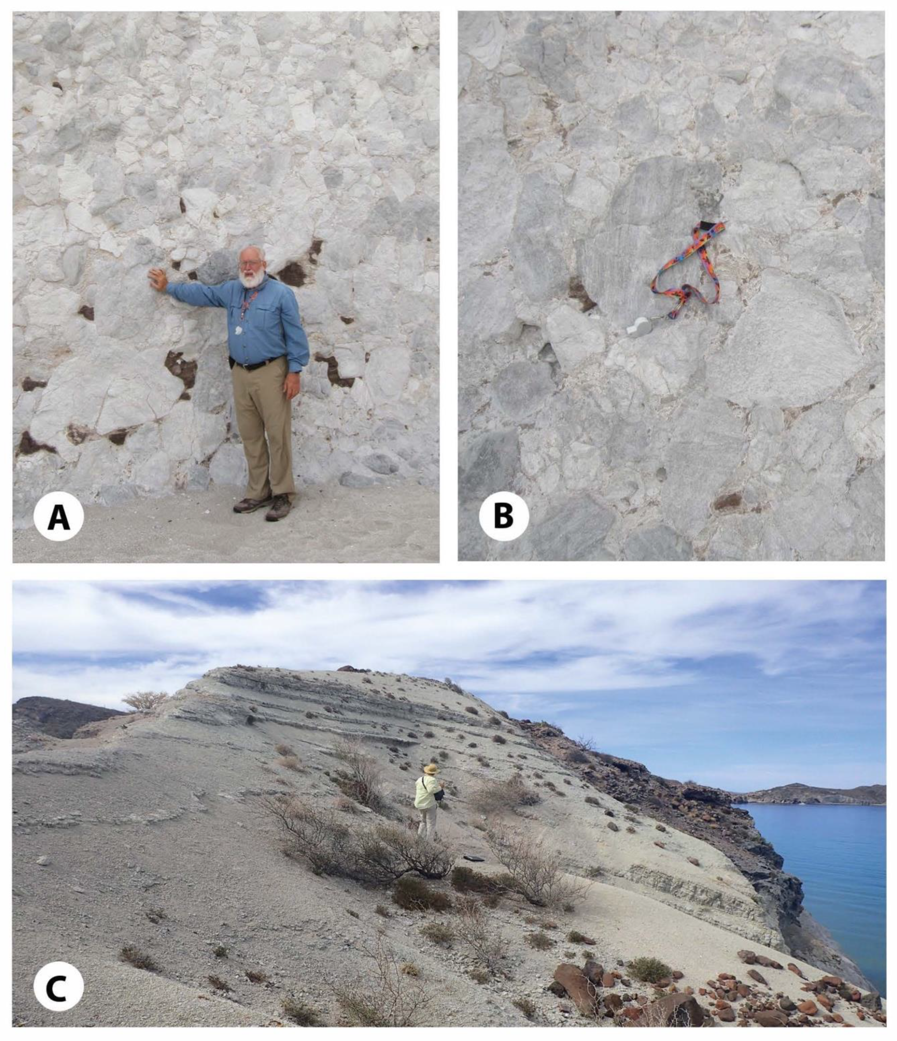
Effusive volcanics from rhyolite domes near Rancho Santa Ana: (A) Re-sedimented hyaloclastite deposit with dark chert inclusions, (B) Closer view of fitted blocks (hand lens and band for scale), (C) Thin-bedded hydromagmatic tuffs above a banded rhyolite flow (person for scale).
The only other available source on San Basilio is a published abstract [8], in which emphasis is given to rhyolitic domes said to have formed under submarine conditions during the middle to late Pliocene. Therein, three stages of volcanism are outlined, including the formation of hyaloclastite breccia, followed by escaping ash, and concluding with bed-load modifications to the substrate by bottom currents and/or tidal action. Analysis using foraminifera to gauge water depth was cited, but without documentation. No mention is made of macrofossils, either for biostratigraphic or facies control.
3. Methods
The methods applied to the present study of San Basilio geology entailed the recording of stratigraphic descriptions and graphic logs to provide details on the intercalation of sedimentary and volcanic rocks at key localities. In addition, volcanic vent locations were mapped and the trend lines of the area’s major faults were traced with attention to fault offsets. Foremost, lithology was mapped during ground traverses with access from roads newly routed during the last few years. In the case of inaccessibility due to the most rugged topography, a drone (Dragon 4™) was flown to film lithotypes and record changes in elevation. All such data were plotted on a base map derived from the Mexican federal government map for Santa Rosa (G12A78). Contour intervals from the government map were scanned and traced to yield a project map with 20-m contours. A 50-gm sample from mudstone in a position above hyaloclastite breccia was collected for microfossils. Foraminifera preparation and interpretation follow the standard techniques [9]. Mega-fossil identifications follow the standard work on Pliocene and Pleistocene paleontology and stratigraphy in the Gulf of California [10].
4. Results of Geologic Mapping
4.1. Volcanic Events
Discerning the overall relationship of igneous rocks, volcanoclastic sediments, and sedimentary strata is complicated by the rugged topography around San Basilio (Figure 2A), but geological mapping confirms the basic outline of key events (Figure 2B). Banded rhyolite is the most pervasive lithology exposed across approximately half the mapped area. High sea cliffs south of Punta Mencenares and around the peninsulas on the north side of Ensenada San Basilio are formed by banded rhyolite. A large rhyolite dome (Figure 2A,B) commands a central position in the basin, rising more than 220 m above sea level.
The region’s most remarkable igneous lithology is demonstrated by hyaloclastite, prominently exposed in low cliffs on the south shore of Ensenada San Basilio around Rancho Santa Ana (Figure 3A). Juxtaposition of individual brecciated blocks of hyaloclastite up to 40 cm in cross-section show variable orientations in the pattern of banding (Figure 3B) typical of re-sedimentation following quench fragmentation. Jigsaw-fitted hyaloclastite is a descriptive term sometimes applied to this condition. Additional outcrops with hyaloclastite deposits also occur below rhyolite flows and intervening siltstones at Rancho Santa Ana (Figure 4A,B). Accumulations of volcanic ash up to 20 m in thickness also cap the hills above Rancho Santa Ana (Figure 3C), segregated well above rhyolite flows (Figure 4A).
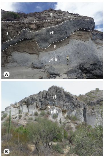
Figure 4.
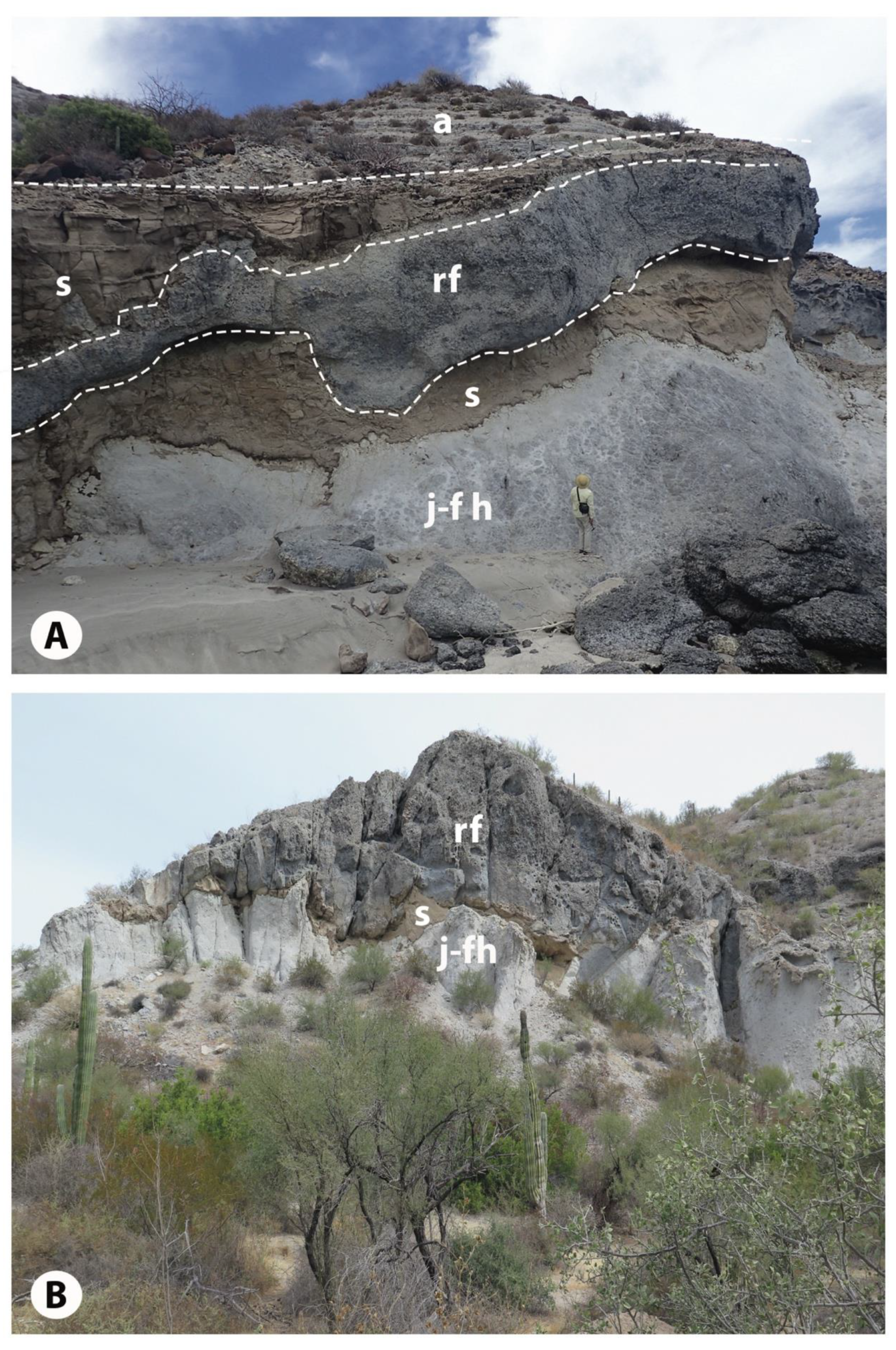
Stratigraphic successions at Rancho Santa Ana: (A) Coastal outcrop with person for scale, showing jigsaw-fitted hyaloclastite (j-fh) at the base, followed by siltstone (s), in turn baked and deformed by banded rhyolite flow (rf), overlain by more siltstone, and capped disconformably by hydromagmatic tuffs (a), (B) Similar sequence with cordon cacti for scale at the Santa Ana corral, showing a lesser amount of siltstone (S) squeezed between underlying hyaloclastite (j-fh) and overlying rhyolite flow (rf).
Volcanic events recorded on the northwest margin of the study area are more difficult to relate stratigraphically to banded rhyolite. Thick ash beds are isolated in laterally extensive cliffs on the north bank of the San Juanico arroyo (Figure 2B). Located eastward on the south shore of the Boca San Juanico, basalt or andesitic basalt shows distinct pillow structures more than a meter in diameter.
4.2. Inter-Relationship of Sedimentary Events
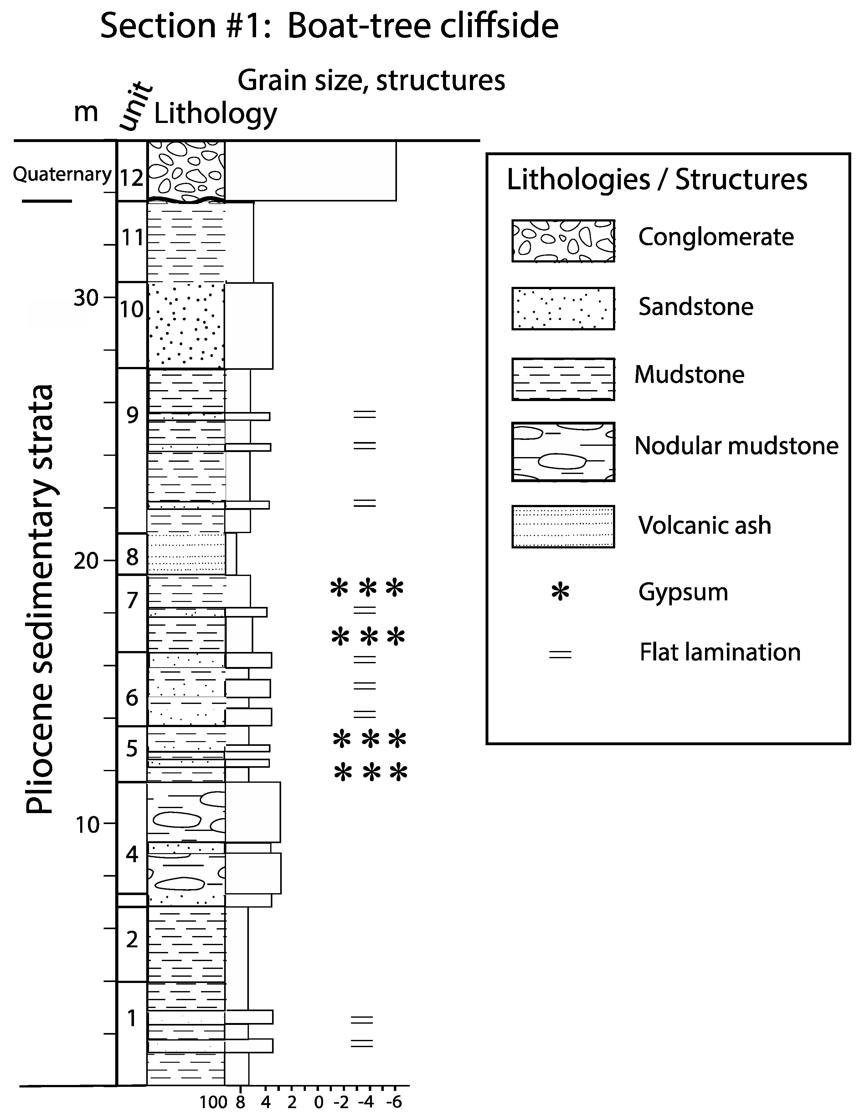
Alternating mudstone and sandstone layers occur on the north side of Ensenada San Basilio exhibited by a thick cliff section above a tree on the shore festooned with boating regalia left by visitors (Figure 5). The detailed description for this section is provided in Appendix A, Section 1.
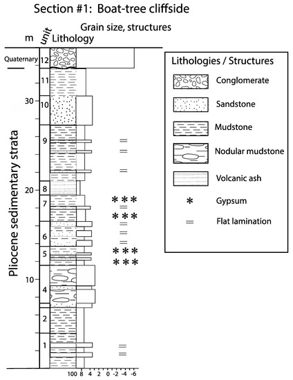
Figure 5.
Stratigraphic succession dominated by interbedded mudstone and sandstone exposed at the Boat-tree cliffside (26°22′18.33″ N; 111°25′48.29″ W). Note: Variations in sediment size are indicated by the phi scale (8 to −6).
The succession is typical of the dominant sedimentary strata across the western and southern shores of Ensenada San Basilio (Figure 2B). In contrast, shore exposures close to the Santa Ana ranch cabin and cliffs above the nearby corral show that sandstone strata with a variable thickness up to 3 m are highly irregular in lateral continuity. Overlying rhyolite flows (Figure 4A,B) demonstrate irregular contacts and local bulges, which suggest that the rhyolite came into sudden contact with cold water or water-saturated sediment. Additionally at the shore, a second sandstone layer is preserved between the top of the rhyolite flow and bottom of ash beds that truncate the sandstone (Figure 4A). In bluffs above the corral, the surface of the rhyolite flow that buried the first sandstone is deeply eroded and there is no surviving evidence of the second sandstone.
Rhyolite flows are localized and laterally discontinuous compared to interbedded sandstone and siltstone strata that dominant exposures along the south shore. A clay-rich sample collected near the base of the thick sandstone–siltstone sequence (500 m east of the Santa Ana ranch cabin) immediately above hyaloclastite yielded a diverse fauna of 28 benthic foraminifera (Table 1) and a lesser fauna of five planktonic foraminifera (Table 2). No age diagnostic planktonic species were detected and, therefore, no age estimation was possible. Relevance of the benthic foraminifera with respect bathymetry at the time of interference by hyaloclastite from below is interpreted in the discussion section. Calcareous nannofossils were noted, but not studied.

Table 1.
Benthic foraminifera species diversity and dominance from a 50-gr. sample collected on the south shore of Ensenada San Basilio (26°20′54″ N and 111°25′ 14″ W). Abbreviations: L = littoral-inner shelf biofacies (0–50 m); O = outer shelf to shelf edge biofacies (50–150 m); U = upper bathyal biofacies (150–500 m).
Table 2.
Planktonic foraminifera species diversity and dominance from the same 50-gr. sample (see Table 1).
Eastward nearly as far as Punta Mencenares (Figure 2B), stretches of sandstone–siltstone bluffs rise between 40 and 50 m above sea level (Figure 6A). Bedding planes exposed near the base of the sequence exhibit extensive networks of horizontal burrows belonging to the trace fossil Thalassinoides sp. (Figure 6B). The sandstone–siltstone succession at this locality is capped by flat-lying limestone beds that thicken southward in excess of 20 m. The Pliocene echinoid Clypeaster bowersi recovered from the base of these limestone beds is an index fossil [10], the relative age significance of which is reviewed in the following discussion section. Limestone strata on the west side of the San Basilio basin (Figure 2B) also are underlain by silty sandstone bearing extensive horizontal burrows of the trace fossil Thalassinoides sp.
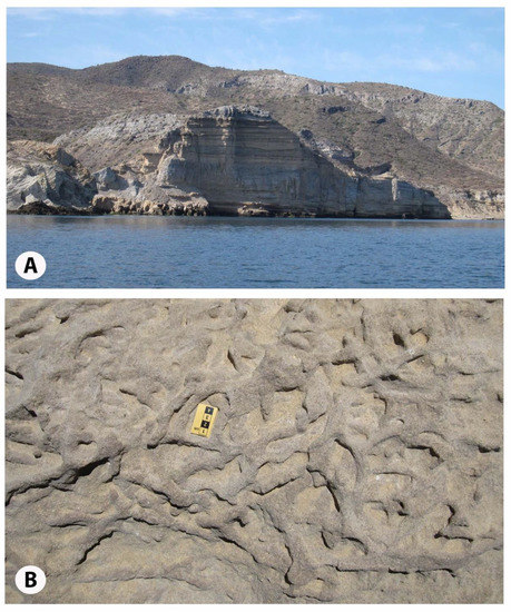
Figure 6.
Coastal outcrops west of Punta Mencenares: (A) Thirty-meter cliff face formed by interbedded siltstone and sandstone with pockets of secondary gypsum, (B) Exposed bedding plane with trace fossils (Thalassinoides) preserved in sandstone.
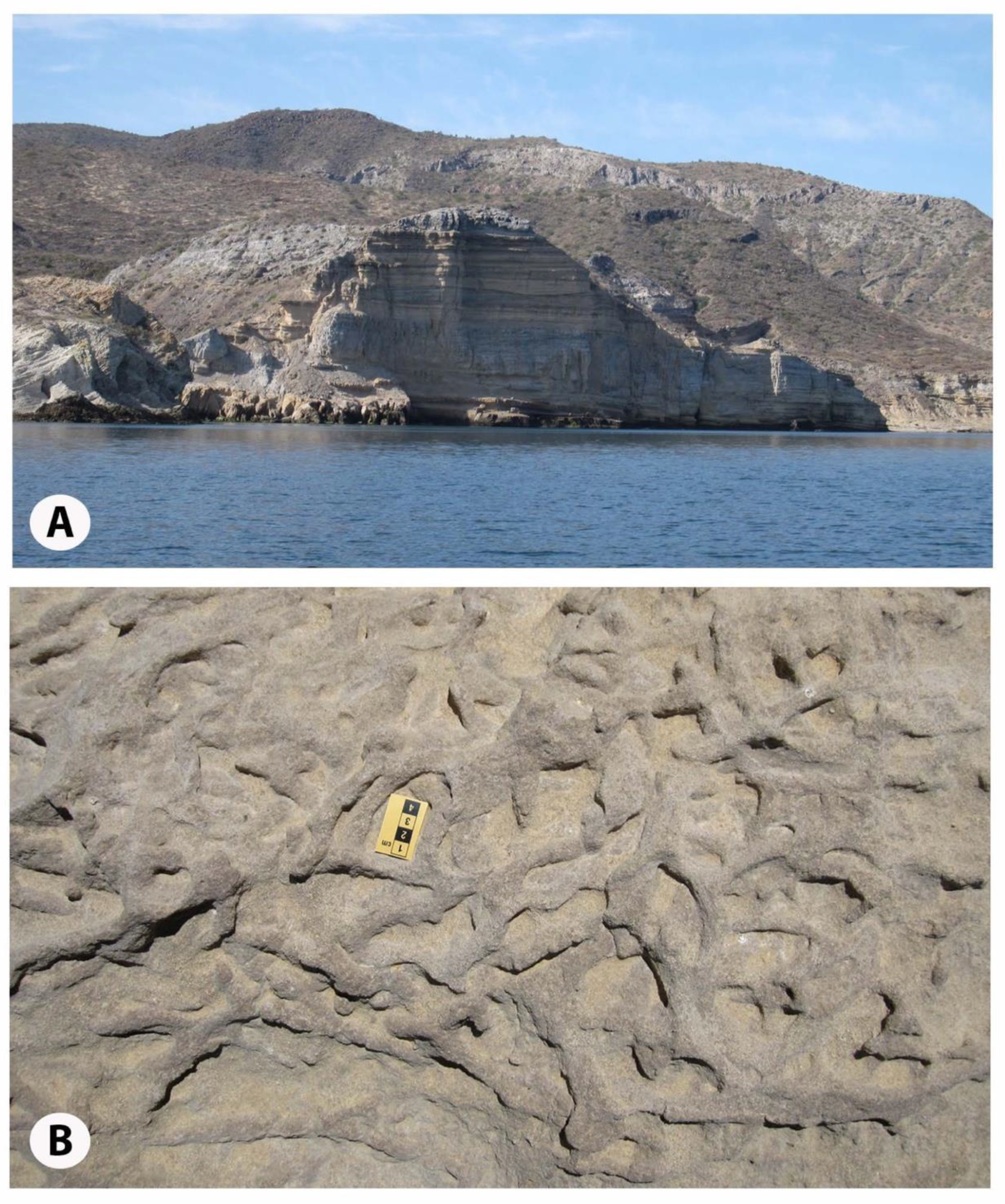
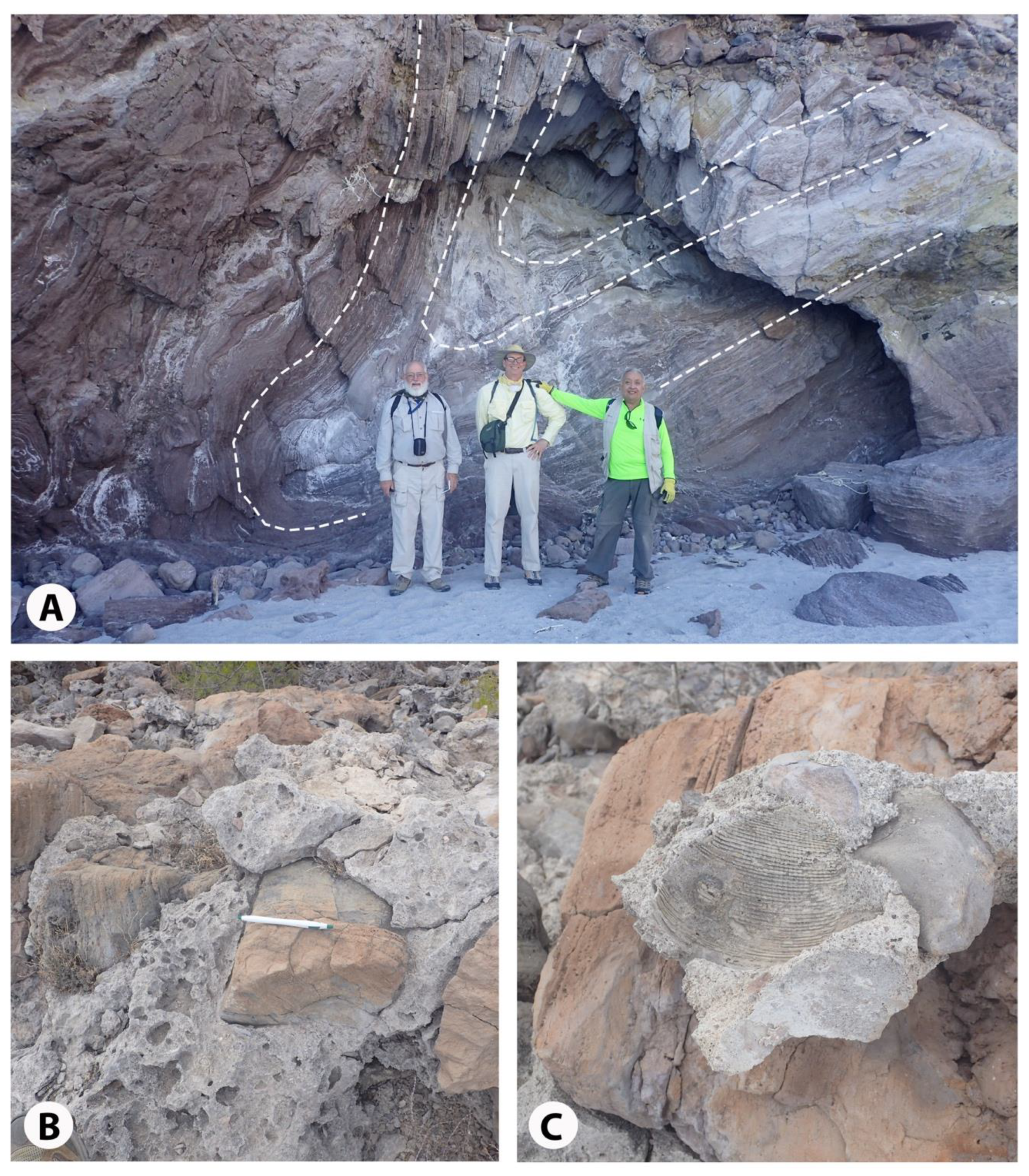
Exposures of rhyolite in the steep side walls of Ensenada Almeja (Figure 2B) rise 40 m above sea level. The extreme plasticity of banded rhyolite is illustrated by a deep fold with a downward-dipping axis ≥ 4 m preserved in a shallow sea cave on the east side of Ensenada Almeja (Figure 7A). Limestone caps the rhyolite massif along a north-south ridgeline that runs 0.5 km inland to the north from the Spanish Contessa’s house. The limestone features a basal conglomerate eroded from the underlying rhyolite. Rhyolite cobbles and boulders from 20 to 50 cm in diameter are encased in a limestone matrix (Figure 7B) that includes external molds of the large bivalve Periglypta multicostata preserved in growth position nestled among rhyolite clasts (Figure 7C). Typically, such a scenario suggests a former rocky shore and the life habit of this extant species is reviewed in the following discussion section. Below the same north-south ridgeline to the east, limestone outliers formed by abundant pecten shells sit on rhyolite as isolated deposits (Figure 2B).
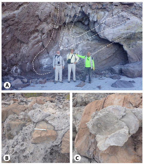
Figure 7.
Details from the east side of Ensenada Almeja: (A) Banded rhyolite at the shore (figures for scale), (B) Basal conglomerate composed of eroded rhyolite cobbles in a limestone matrix (pen = 12 cm), (C) Loose piece of conglomerate with external mold of a large bivalve (Periglypta multicostata preserved in the limestone matrix.
4.3. Exhumed Volcanic Necks and Related Limestone
Several volcanic vents or exhumed volcanic necks are marked on the geological map for the San Basilio basin (Figure 2B). Three examples are represented by spires of vertically fractured rhyolite that rise above the waters of the San Basilio embayment as sea stacks. Two such clusters can be visited at Punta Mencenares on approach by boat from the southeast into the main bay.
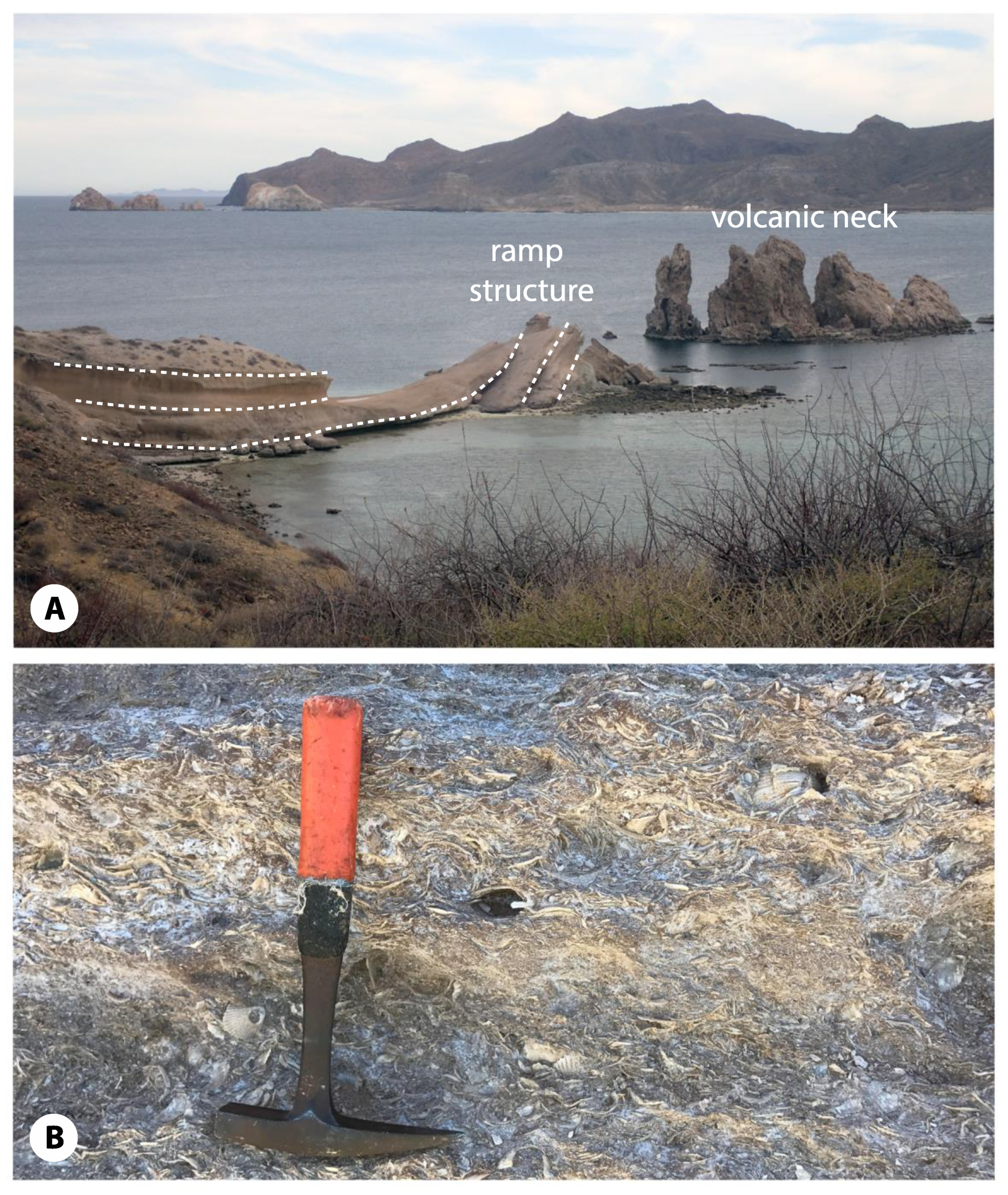
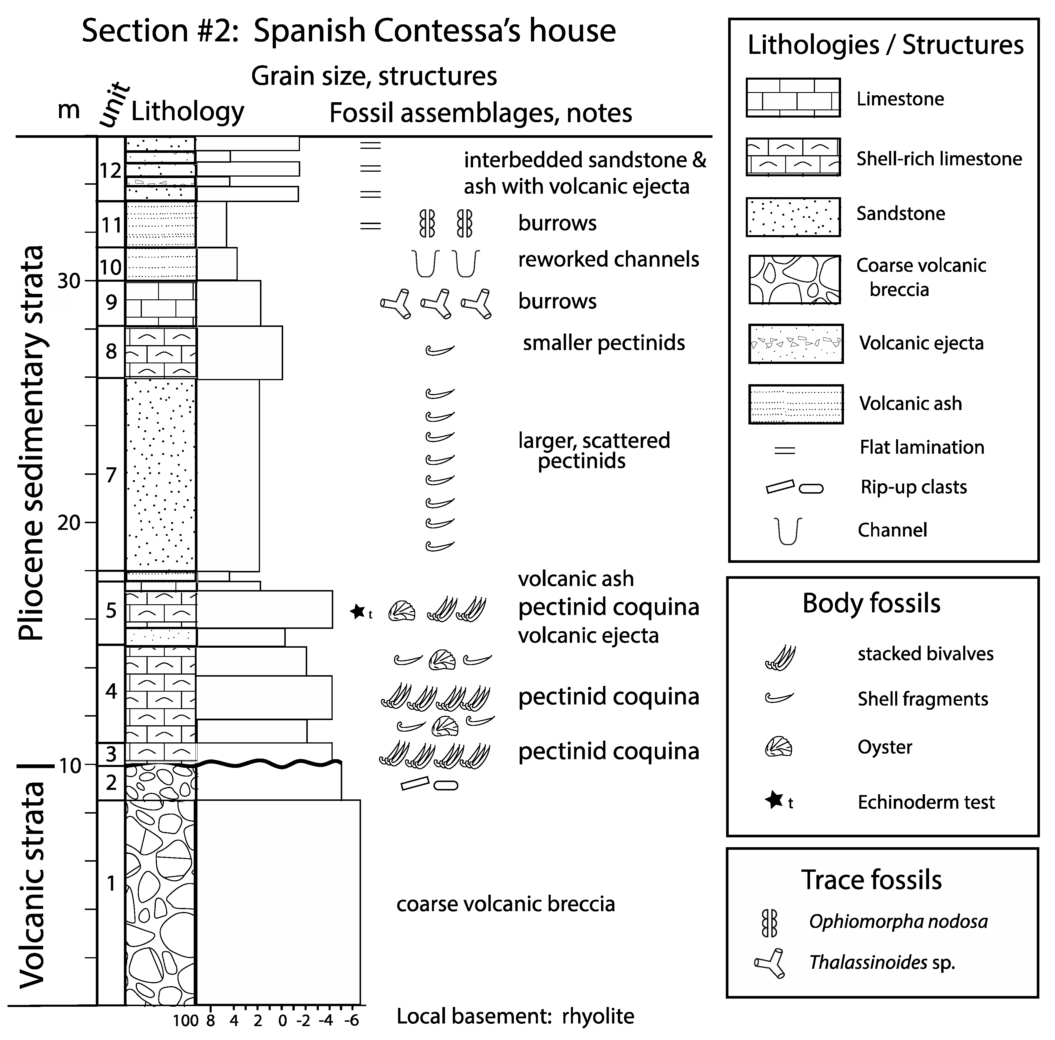
A third example is well within the bay below the Spanish Contessa’s house (Figure 2B), where a bridge of bedded limestone projects outward 125 m from the coast separated from the closest rhyolite spires by 90 m of open water. Carbonate layers that plank the bridge appear flat-lying near the shore, but bend upward at a high apparent angle closer to the rhyolite sea stacks to form a synsedimentary ramp structure (Figure 8A). The exposure at this locality features an unconformity between the local rhyolite basement and overlying Pliocene sedimentary sequence. A detailed description of strata compiled for this site (Appendix A, Section 2) records a dip of 12° about 10 m below the top of the 35-m thick succession. A graphic representation of the rock column is provided in Figure 9.
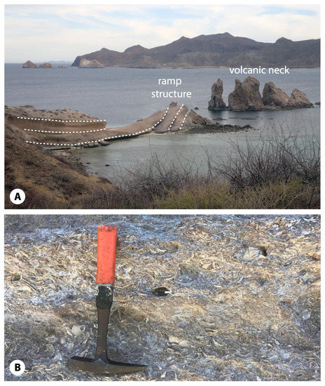
Figure 8.
Rock formations below the Spanish Contessa’s house on the north shore of Ensenada San Basilio: (A) View southeast showing rhyolite spires in the far distance at Punta Mencenares (upper left), more rhyolite spires in the middle ground (right), and a carbonate bridge pointed southward through up-turned layers toward the adjacent volcanic spires (lower left), (B) Densely packed pecten-shell coquinas from bottom of north-dipping ramp (see Appendix A, Unit 4) with rock hammer for scale.
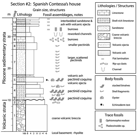
Figure 9.
Shore succession immediately south of the Spanish Contessa’s house (26°22′13.40″; 111°25′44.93″ W). Note: Variations in sediment size are indicated by the phi scale (8 to −6).
Strata in the lower part of the succession are dominated by shell coquinas. Northward dipping basal layers (Figure 8B) consist of disarticulated pecten shells and rare oysters densely packed with evidence of shell imbrication. Unusual examples of pecten shells incorporated within mud balls up to 20 cm in diameter are noted (Appendix A, Section 2, Unit 3). Below the coquinas, a thick volcanic breccia with sub-rounded blocks up to 1.5 m in diameter changes over to a volcanic agglomerate with rounded pebbles to small boulders of rhyolite up to 30 cm in diameter (Figure 9, units 1 and 2). Blocks of welded ash as much as 40 cm in cross-section are found in some upper limestone layers (Appendix A, Section 2, Unit 5). A marker bed formed by volcanic ash interrupts the sedimentary succession at a horizon 6.8 m above the base (Section 2, Unit 6). Layers of sandstone with scattered, small pecten shells follow above the marker bed with interbedded sands and volcanic ash becoming more prevalent, thereafter.
Above the shore about 500 m west of the Spanish Contessa’s house (Figure 2B), another example of vertically fractured rhyolite is exposed in cliffs that offer an east-west cross-section, also including limestone beds formed by abundant fossil pectens on opposite flanks. The scale of this feature is commensurate with the more dramatic scenario of the rhyolite sea stacks and related sedimentary bridge below the Spanish Contessa’s house (Figure 8A).
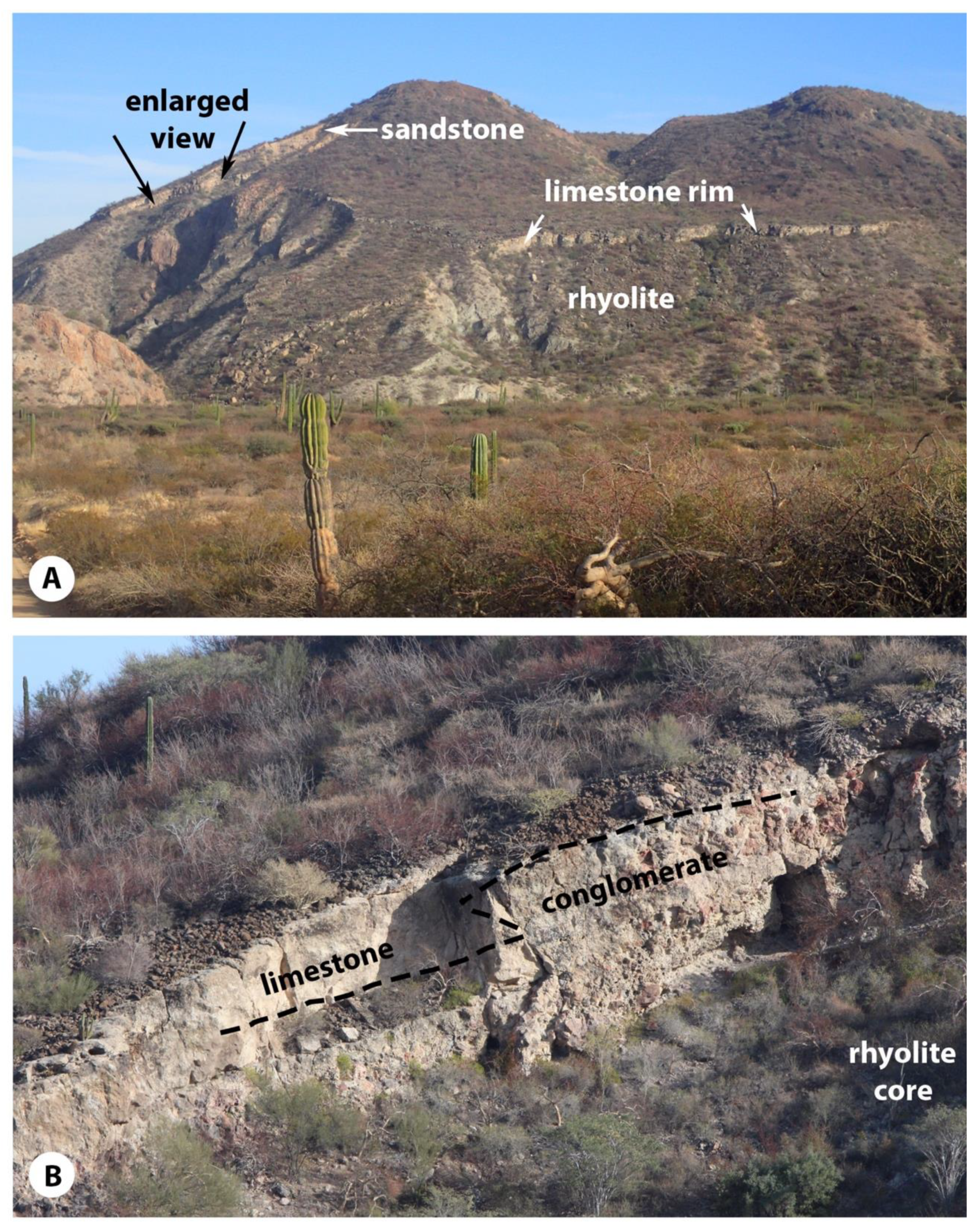
Mostly intact, the largest rhyolite dome in the San Basilio basin exhibits a superstructure that rises more than 220 m above sea level roughly 1 km inland from the bay’s west shore (Figure 2A,B). Viewed from the northwest (Figure 10A), part of the structure’s core is exposed in a cliff face to reveal about 60 m of vertically-fractured rhyolite consistent with sea stacks in the bay. Explored on foot to the 100 m-elevation, the big dome features a limestone rim that follows in a ~4-m thick band around its northern and western slopes. Fossil oysters are a substantial component of the limestone. Closer examination of the vertiginous north wall was performed using a drone, which gave a clear image of conglomerate beds approximately 2-m thick stratigraphically wedged between the top of the rhyolite and the limestone, but also revealing a lateral facies relationship (Figure 10B). As much as 20 m of sandstone and interbedded limestone follow above the interface of conglomerate and limestone (Figure 10A), with horizontal stratification apparent across the north face of the dome structure. In this instance, the superposition of thick sandstone directly above limestone is unusual on a regional basis. If sandstone once blanketed the limestone plateau in the northern part of the San Basilio basin, it was subsequently removed by erosion. The upper part of the big dome features ~15 m of andesite flows. Twin vents (Figure 2B) are discernable at the top of the dome with the aid of drone surveillance. The more southerly vent is apparent as viewed from the northeast from across the bay, as it sits within a distinctly cratered depression.
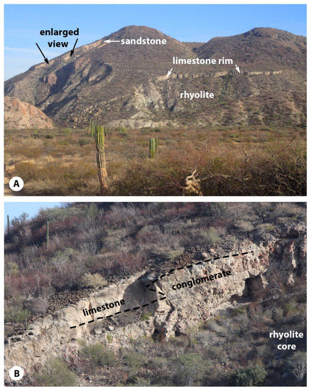
Figure 10.
Rhyolite dome from the central part of the San Basilio basin: (A) View to the southwest toward the dome with the eroded rhyolite slope and overlying limestone rim marked, in addition to an exposure of sandstone (white arrows) in the middle part of the structure. Note area of enlargement (black arrows) shown below. (B) Enlargement (from above), showing the relationship between limestone and rhyolitic conglomerate eroded from the core of the dome.
4.4. Regional Faults
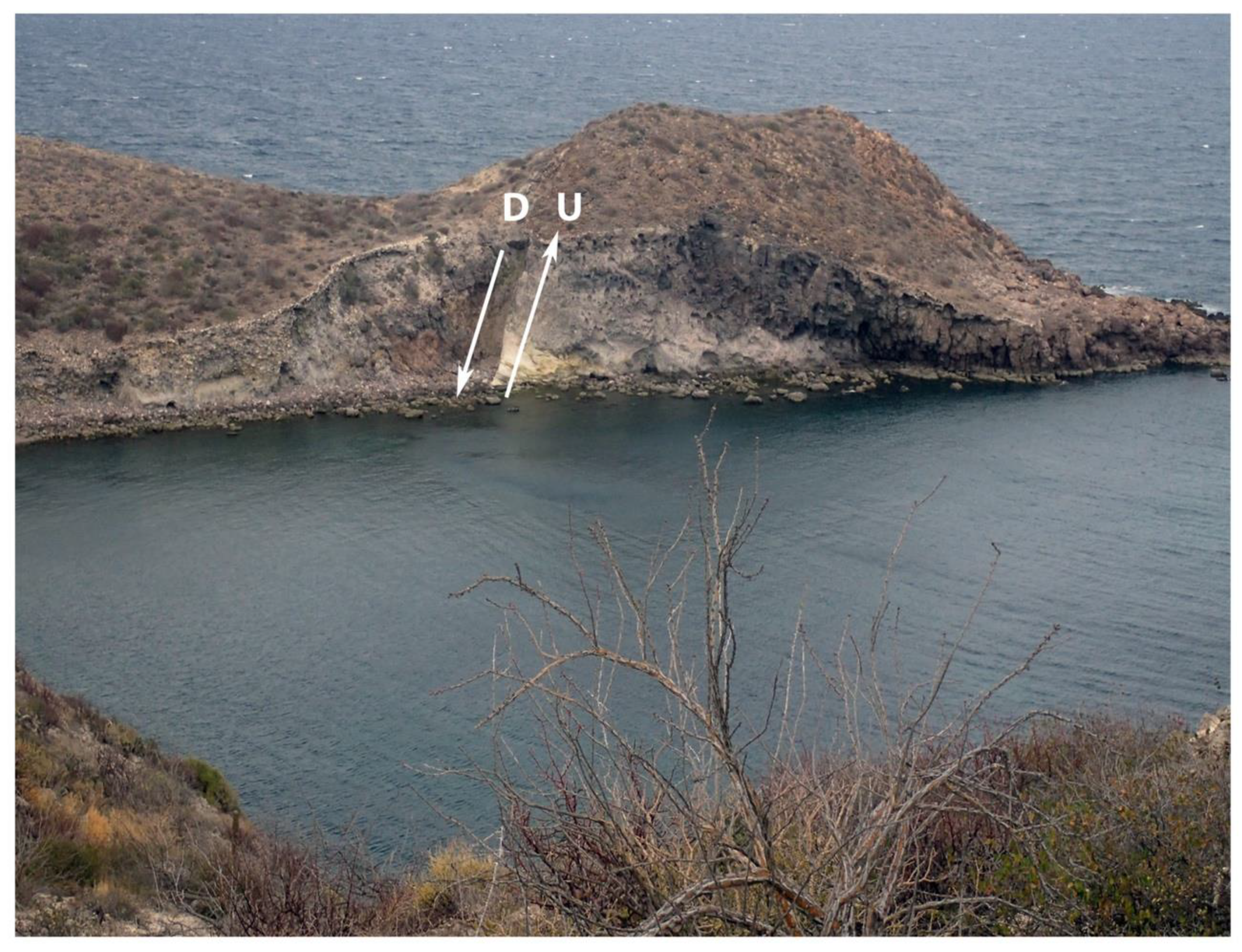
Arroyos that coalesce on the San Basilio estuary at the center of the San Basilio basin are dendritic in organization. Overall, they trace a drainage pattern that empties to the east. In contrast, a strong overprint of fault lines exists on the basin’s periphery that controls narrow valleys with mainly north-south orientations. Two distinct fault patterns cross one another. A north-south fault valley descends to Punta Mencenares in the southeast part of the basin (Figure 2B). On the opposite side of the basin, another north-south valley cuts across the north-east peninsulas to link the Almeja and San Basilio embayments. A parallel north-south valley also runs between adjacent limestone-capped plateaus starting inland from the coast about 1 km east from the mouth of the San Juanico arroyo (Figure 2B).
Two parallel faults that strike from N 28° E to S 28° W cross through the north-east peninsulas (Figure 2B) and may extend to the center of the San Basilio basin. A substantial offset of about 10 m on a normal fault lifted a rhyolite dome on the outer part of the north-eastern peninsula to a higher elevation (Figure 11). Another set of parallel faults follow a similar trend crossing through the south shore of Ensenada San Basilio. Rancho Santa Ana along the southern edge of the bay sits within a half-graben structure that accommodates a broad beach and low coastal plain with superior exposures of re-sedimented hyaloclastite. It is likely these faults continue northeast into the bay.
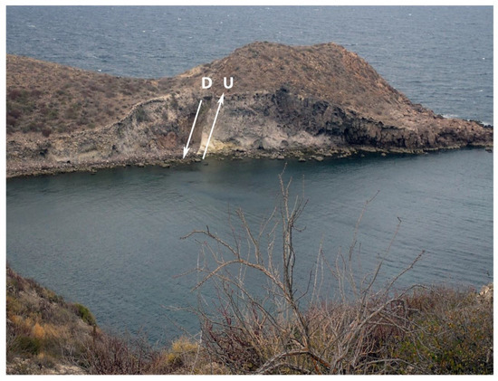
Figure 11.
Normal fault through a rhyolite dome exposed in the side wall of a small embayment east of Ensenada Almeja (see NE-SW trending fault in Figure 2B).
5. Discussion
5.1. Stages of Volcanism and Basin Development
The spatial distribution of hyaloclastite, banded rhyolite, and vertically fractured rhyolite spires suggests multiple stages of development in the San Basilio basin. Ponza and Gavi are islands off the west coast of Italy in the Tyrrhenian Sea, where iconic examples of subaqueous lavas are well described as distinguished by hyaloclastite [11]. There, felsic lavas with high-silica content resulted from effusive submarine eruptions. Hyaloclastite derives from quench fragmentation, where magma is chilled by water to produce fractured glass under thermal stress. Jigsaw-fitted hyaloclastite is exemplified on Ponza, where rotation of quenched clasts relative to one another is interpreted to occur during intrusion of new magma in an expanding submarine lava dome [11]. Laminar flow banding in rhyolite is influenced by migration of gasses released by crystallization during highly viscous extrusion. As observed in the east wall of Ensenada Almeja (Figure 7A), recumbent folds in banded rhyolite are interpreted as the result of lava extruded in a radial pattern under the influence of gravity as it flowed outward from a nearby vent. In contrast, vertically fractured rhyolite spires are exposed by differential erosion as volcanic necks at the center of rhyolite domes.
The earliest widespread phase of volcanic activity in San Basilio bay involved the creation of hyalosclastite as incipient domes grew beneath extensive marine mudstone and sandstone, examples of which are well exposed in discontinuous outcrops around the perimeter of the bay (Figure 2A). Exposures of re-sedimented hyaloclastite are especially well preserved on the south and west shores of Ensenada San Basilio, where overlying sandstone–siltstone strata are left intact. Less well represented on the north shore west of the Spanish Contessa’s house (Figure 2B), a thick wedge of interbedded sandstone and siltstone strata is correlated with the more extensive deposits on the west and south shores (Figure 5; Appendix A Section 1). Likely by means of explosive rupture from below and subsequent submarine erosion, the sandstone–siltstone facies disappeared from the approximately 4 km2 area of present-day San Basilio bay under the influence of strong bottom currents.
The next phase of volcanic activity involved expansion of numerous rhyolite domes in the central and northern parts of the San Basilio basin, typically distinguished by flow banding. Several large domes coalesced, especially in the northern part of the basin. The largest, free-standing dome with two well preserved vents occupies the central part of the basin (Figure 2B). The top of the rhyolite core in the large central dome was exposed to subaerial erosion, as indicated by rhyolitic conglomerate that inter-fingers with limestone around its perimeter. The same facies relationship is found on the flank of another rhyolite dome north of the Spanish Contessa’s house. Smaller domes sat beneath volcanic islets within the yet flooded San Basilio embayment. Sea stacks formed by vertically fractured rhyolite mark the vent locations of those islets today. The final stage of volcanic activity entailed intermittent explosions that sent large amounts of ash into the air recorded by extensive tuff layers both on the north and south sides of the bay. In particular, the large rhyolite dome at the center of the San Basilio basin was the locus of renewed volcanic activity that brought surface flows spilling over the margins of the dome from a pair of vents.
5.2. Paleobathymetry
Following the protocol for Recent and subfossil benthic foraminifera [9], the sample collected from the base of sandstone–siltstone strata east of Rancho Santa Ana was found to be dominated (66.61%) by species characteristic of an outer and inner biofacies (Table 1), most likely deposited near an upper bathyal depth as great as 150 m under conditions of reduced oxygen. This interpretation is based on the presence of almost equal proportions of Bolivina bicostata and B. interjuncta. High abundances of the later species are reported from the upper bathyal oxygen minimum zone along the East Pacific Margin [12], as well as from the outer shelf biofacies (73–152 m) in the Gulf of California [9]. Scarce occurrences of other upper bathyal, low-oxygen species such as Buliminella tenuata, Bolivina pacifica, and B. sp. cf. spissa also support such a depth interpretation. In this case, the abundance of outer-shelf edge species (53.04%) and the presence of rare upper bathyal species places the sample at a maximum depth between 100 and 150 m, probably within an environment with slightly low content of dissolved oxygen. Essentially, this finding also delimits the bathymetric setting soon after the re-sedimented hyaloclastite deposits formed after highly explosive hydromagmatic conditions. Our result is in general agreement with the undocumented bathymetric estimate of 110 m for initial basin development previously reported in abstract form [8].
Extensive sandstone–siltstone strata with abundant Thalassinoides trace fossils are interpreted as having formed within an ecological window below fair-weather wave base but above the level of oxygen starvation that provided sufficient oxygen for the burrow makers [13]. At a maximum water depth of 120 m, burrow inhabitants still had enough oxygen but also were sheltered against severe storms that otherwise might destroy their habitat. Hence, the Thalassinoides habitat is considered to range no deeper than 120 m, an estimate that fits well in position above the sample of benthic foraminifera from the base of the sandstone–siltstone succession in more poorly oxygenated waters.
Capstone carbonate strata in scattered outliers and entire plateaus across the northern part of the study area (Figure 2B) feature abundant bivalves often dominated by fossil pectens. Seventeen pectinid species from Pliocene strata in Baja California have been described [10]. Poor preservation makes it difficult to pin down accurate identifications from any of the Basilio pectenids, although Aequipecten abietis was found to be the most abundant representative from Pliocene strata in the nearby El Mangle area to the south [14]. Living pectens are entirely subtidal in distribution and a common species such as Argopecten circularis with fossil representation in Baja California is known to occupy water depths from 1 to 135 m [15] (p. 87). On the basis of stratigraphic position, the pecten beds that follow after sandstone–siltstone layers with the Thalassinoides facies thrived in shallower waters subject to frequent disturbances above normal wave base.
The basal conglomerate composed of banded-rhyolite cobbles and boulders on the ridgeline north of the Spanish Contessa’s house is especially significant for inclusion of fossil bivalves [10] belonging to the venerid Periglypta multicostata. This species is the largest venerid bivalve living today in coastal habitats from western Mexico to Peru. It is restricted to a sandy substrate nestled among rocks at extreme low tide [15] (p. 161). Hence, there is strong support for interpretation of an inter-tidal rocky shore that commenced with deposition of Pliocene mixed conglomerate and limestone in the San Basilio area.
Unique to the San Basilio basin, the carbonate bridge below the Spanish Contessa’s house (Figure 8A) is of particular interest because nothing like it is reported elsewhere from the Pliocene of Baja California. Evidence from the 35 m succession of interbedded limestone, sandstone, and ash beds within the sequence (Figure 9; Appendix A, Section 2) suggests it accumulated coeval with but subjected to the disruptive growth of a small volcano, the neck of which is exhumed in nearby sea stacks. The upward turn in strata at the end of the broken bridge is interpreted as mainly syndepositonal in origin, but also having been disturbed by magma expansion from below that led to direct volcanic warping of the overlying strata. Hence, the surviving configuration represents the erosional remnants of a sedimentary ramp structure that formerly surrounded the volcano on all sides.
Evidence in support of a steeply inclined surface on the submarine flank of a volcano derives from bands of shell coquina formed by densely imbricated pectens, as well as mud balls that also incorporate pecten-shell debris. Gravity flows were likely to have been caused by shaking in the immediate area during the expulsion of volcanic ash. Although unrelated to a volcanic setting, similar phenomena including transported shell coquinas and mud balls was interpreted as a gravity slide off a pre-existing shelf in the Pliocene of Isla Monserrat [16]. Evidence to support volcanic co-development at San Basilio is credible on the basis of sizable tuff blocks incorporated within limestone layers, in addition to a 30 cm thick ash bed that appears 6.80 m above the base of the sedimentary package. The succeeding limestone and sandstone beds incorporate an increasing fraction of volcanic ash.
The structural integrity of the carbonate bridge and rhyolite sea stacks is preserved in a small half graben topographically below the prominent ridgeline of limestone north of the Spanish Contessa’s house (Figure 2B). As such, the carbonate bridge represents the seaward extension off a rocky shore, interfacing with a small volcano. Elsewhere around the bay, hyaloclastite is intimately related only with overlying beds of sandstone and siltstone (Figure 4A,B) deposited earlier in a deeper-water setting during a more intense phase of volcanic activity.
5.3. Biostratigraphic Correlation
Most of the limestone in the San Basilio basin is regarded as the final stage of basin development prior to dissection by faults, whether in succession above sandstone strata or in direct contact on an erosional surface with rhyolite. The sea urchin index fossil Clypeaster bowersi from basal limestone in the southeast part of the basin has a wide distribution in Pliocene strata throughout Baja California [10]. In the scheme of concurrent range zones from the thick Pliocene succession at Arroyo Blanco on Isla del Carmen, this species has been placed [17] at the top of the Lower Pliocene as previously defined [10]. In formal stratigraphic nomenclature, this level is equivalent to the upper part of the Zanclean Stage in the Lower Pliocene.
On the basis of other considerations including fault relationships, San Basilio limestone was likely to have spanned the lower part of the succeeding Piacenzian Stage (further elaborated in discussion, below).
5.4. Fault Patterns and the Pliocene Gulf of California
North-south faults in the San Basilio basin mirror the many north-south faults previously mapped by Bigioggero et al. [7] (Figure 3, therein) on the Cerro Mencenares volcanic complex adjacent to the south. Moreover, the 5 km long El Mangle lineament [14] (Figure 2, therein) connects with the north-south fault that exits into San Basilio bay near Punta Mencenares (Figure 2B). These north-south faults conform to the pattern of east-west crustal extension during an early tectonic stage in the opening of the proto-gulf that ended as late as 3.5 million years ago [18].
At the south end of the Mangle fault block, an unusual scarp with a fault trend oriented N 55° W to S 55° E, was named El Coloradito [14]. That orientation runs parallel to active transform faults in the present-day Gulf of California and is regarded as an early manifestation of transtensional tectonics in the Gulf of California. No fault trends of this kind are apparent in the San Basilio basin, but faults with an orientation N 28° E to S 28° W through the north-east peninsulas (Figure 2B) are offset from El Coloradito by sixty-three degrees. A full ninety degrees would bring those faults into alignment with spreading zones in the present-day Gulf of California. The short-fall, however, does not eliminate a connection with transtensional tectonics that stressed the basin in another dimension during the earliest stages of a new tectonic regime. In that case, the final events to affect the San Basilio basin occurred no earlier than about 3.5 million years ago. Carbonate ramps at El Mangle prior to offset by El Coloradito fault were dated to 3.3 million years ago on the basis of tuff beds near the base of the ramps [14]. By extension, this approximate date would place the some of the thick limestone beds in the adjacent San Basilio basin within the lower part of the Pliocene Piacenzian Stage.
5.5. Comparisons with Other Volcanoes in the Gulf of California
Rhyolite domes outside the San Basilio basin are rarely found within or adjacent to the Gulf of California. The prime example is Isla San Luis in the upper gulf region (Figure 1A) with a pair of intact rhyolite domes that measure from 0.5 to 1 km in diameter and reach a maximum elevation 175 m above sea level. Surface deposits on the domes include rhyolitic bombs that have an obsidian crust indicative of subaerial activity [2]. Isla Tortuga, located in the midriff area of the gulf (Figure 1A) is a shield volcano composed of Hawaiian-style tholeiitic basalt [3]. The island’s superstructure rises more than 200 m above sea level and exhibits a central crater with a diameter of 1250 m. Including that part of the superstructure below sea level, the complete Tortuga volcano matches the entire San Basilio basin in scale. Closer to Loreto (Figure 1A,B), Isla Coronados is a classic stratovolcano with a superstructure that rises more than 275 m above sea level and features well-preserved andesite flows. It is roughly two-thirds the size of Isla Tortuga above the waterline, more than enough in size to occupy San Basilio bay. No older than Holocene in age, San Luis and Totuga are very young, whereas the youngest lava flows on Coronados date to the later Pleistocene at 160,000 years in age [4].
Among the three island examples, only Coronados includes a substantial fossil record represented by a coral reef in a paleo-lagoon on its southern, leeward side [5]. Given the older, mid-Pliocene status of the rhyolitic domes and volcanoes in the San Basilio basin, it is remarkable so much of the carbonate bridge and related volcanic slope deposits has survived (Figure 7A). Compared to the Pleistocene coral reef on Coronados which dates between 121,000 and 127,000 years in age and reached mean sea level due to upward growth [5], the pecten coquinas and mud balls from gravity slumps on the slope of a small volcano accrued in deeper waters, but still likely close to fair-weather wave base.
5.6. Comparison with Oceanic Volcanoes Elsewhere
Oceanic islands are mostly volcanic in origin composed of basalt. Aside from fossil coral reefs that form the basis of atolls around former volcanic islands, few such volcanoes are well understood from the literature as retentive of marine sedimentary deposits with any paleoecological value. Ponza and Gavi in Italy’s Pontine archipelago are noteworthy for their rhyolitic lava domes [11], for example, but their island flanks preserve no marine sediments or megafossils. Much inspired by the available literature on Italian volcanoes, Charles Darwin was among the earliest naturalists to draw attention to non-reef limestone preserved as shallow, subtidal deposits around basalt islands such as Santiago in the Cape Verde archipelago [19]. Fossil rhodoliths secreted by coralline red algae contributed to substantial Pleistocene deposits against basalt rocky shores on Santiago and other, older islands in the Cape Verde, Madeira, and Azores islands. Much to Darwin’s disappointment, the basaltic Galapagos off the coast of Ecuador failed to reveal similar carbonate deposits during his visit there in 1835. However, island carbonates are present in the Galapagos, as for example Holocene beach sands preserved as over-wash deposits between basalt flows on Isla Sombrero Chine [20]. Perhaps the best example of a volcano-slope deposit similar to the Pliocene shell coquinas and mudballs from San Basilio was described from the middle Miocene of Ilhéu de Baixo in the Madeira archipelago [21]. In particular, a carbonate facies dominated by broken branches of the fossil coral Pocillopora madreporacea occur within a gravity slide on the steep submarine flanks of a volcano with prevalent Surtseyan deposits from frequent ash eruptions.
6. Conclusions
Observations from geologic mapping and interpretations with respect to inter-related patterns of volcanism and sedimentation support the following conclusions at the level of a reconnaissance overview of landscape evolution in the San Basilio basin.
1. The earliest widespread, post-Miocene phase of volcanic activity commenced with submarine domes filled with hyaloclastite that impinged on overlying siltstone and sandstone strata. Examples of re-sedimented hyaloclastite are documented for the first time in Mexico’s Baja California, matching classic textbook examples of hydro-magmatic volcanism in Ponza, Italy.
2. Based on bathymetric analysis of foraminifera with nearly equal proportions of Bolivina bicostata and B. interjuncta from mudstone at the base of the siltstone-sandstone succession above hyaloclastite, seawater at the time of magmatic injection was no more than 150 m deep under conditions of reduced oxygen. Better oxygen levels in silty sediments at a slightly shallower water depth supported organisms that made extensive Thalassinoides burrows.
3. A subsequent phase of volcanic activity occurred with introduction of rhyolite domes characterized by extensive flow banding sometime after destruction and erosion of sandstone and siltstone strata at the center of the paleobay at San Basilio. Substantial domes were emplaced in the central and northern parts of the basin.
4. Widespread Pliocene limestone overlies rhyolite domes exposed to wave erosion that led to intertidal conglomerates inhabited by the venerid bivalve Periglypta multicostata. This large bivalve is extant and dwells nestled among cobbles at extreme low tide. Another carbonate facies off former rocky shores is represented by pecten bivalves that lived in water depths above wave base on rhyolite substrate where sorting and imbrication of disarticulated shells was common.
5. A unique variation on the pecten-shell facies is preserved as a slope cover around a small volcano with an exhumed neck of vertically fractured rhyolite in San Basilio bay. Influenced by magma expansion from below as well as shaking during expulsion of volcanic ash, gravity slumps on a steep slope are indicated by densely imbricated shells and mud balls. Volcanic activity continued apace during carbonate deposition registered by sizable tuff blocks and other volcanic detritus incorporated within the limestone, as well as emplacement of a tuffaceous marker bed.
6. North-south faults define valleys in the present-day landscape that are attributed to east-west extension during an early phase of tectonism in the Gulf of California ending roughly 3.5 million years ago. Residual effects from the changeover to transtensional tectonics are suggested by cross-cutting faults with a trend N 28° E to S 28° W. The sea urchin index fossil Clypeaster bowersi from the base of San Basilio limestones indicates a position in the upper part of the Zanclean Stage (Lower Pliocene). Ongoing limestone deposition prior to transtensional faulting was likely to have concluded at a level equated with the lower Piacenzian Stage (Upper Pliocene) based on dated tuff in strata from the nearby El Mangle to the south.
Author Contributions
M.E.J. and D.H.B. jointly led students during the initial visit to San Basilio in January 2001. D.H.B. organized the first student mapping project at San Basilio in March 2011 and M.E.J. led the second student project in March 2016. They were joined by J.L.V. in March 2017 for field consolidation of the maps, during which M.E.J. took charge of megafossil analysis, D.H.B. supervised stratigraphic logging, and J.L.V. oversaw the mapping of faults in connection with a review of regional tectonics. A.L.C. conducted the analysis of microfossils. Manuscript revisions were orchestrated by M.E.J.
Funding
This research received no external funding for fieldwork. Financial support for analysis of microfossils was provided by the Programa de Apoyo a Proyectos de Investigación e Innovación Tecnológica (PAPIIT), UNAM project IN102314¿Existió el protogolfo de California en el Mioceno medio?
Acknowledgments
Progress in field mapping advanced during successive excursions to the San Basilio basin organized for geology students from Williams College in January 2001, March 2011, and March 2016. Special thanks are due to Tom Woodard in Loreto for arranging visits to the Spanish Contessa’s house overlooking Ensenada San Basilio. Norm Christy, part-time resident of Loreto, helped with logistics during the 2016 excursion providing additional housing in Loreto, as well as field transportation and good company during our March 2017 visit. Ricardo Ramalho (Bristol University and Dom Luiz Institute at Lisbon University) lent his expertise and recommended sources on island volcanism associated especially with hyaloclastite deposits. Richard Emmerson flew his drone (Dragon 4™) in support of aerial reconnaissance over the big rhyolite dome near the center of the San Basilio basin. The authors are grateful for two anonymous reviews that were helpful in revising the manuscript.
Conflicts of Interest
The authors declare no conflict of interest.
Appendix A
Section #1: Boat-tree section (tree branches hung with yachting regalia) located 175 m west of the Spanish Contessa ’s house (north shore of Esenada San Basilio). See Figure 5 for graphic representation.
Section #1: Boat-tree section (tree branches hung with yachting regalia) located 175 m west of the Spanish Contessa ’s house (north shore of Esenada San Basilio). See Figure 5 for graphic representation.
| Thickness (meters) | |
| Unit 12: Conglomerate (reddish brown) composed of well-rounded cobble-to- boulder size clasts of rhyolite and andesite above an undulating unconformity | 2.50 |
| Unit 11: Mudstone (tan). | 3.00 |
| Unit 10: Sandstone (tan to brown), medium to coarse grained | 3.75 |
| Unit 9: Dominant mudstone (yellow-tan) with thin sandstone interbeds (from 10 to 15 cm thick). | 6.25 |
| Unit 8: Volcanic ash (gray) with basal 15-cm thick layer of coarse fragments From 1 to 2 cm in diameter | 1.25 |
| Unit 7: Dominant mudstone (tan) with a single, fn. grained sandstone Layer accounting for 3% of the whole; secondary gypsum veins. | 2.70 |
| Unit 6: Dominant sandstone (yellow), very fn. grained with interbedded Mudstone (tan) in thin layers on average 5 cm thick. | 2.75 |
| Unit 5: Balanced combination of interbedded mudstone (tan) and sandstone (yellow) with layers on average 25 cm thick; secondary gypsum veins. | 2.00 |
| Unit 4: Nodular mudstone (tan) with a single, medium-grained sandstone interbed that accounts for 5% of the whole. | 4.00 |
| Unit 3: Sandstone, (yellow), very fn. grained with a single mudstone inter- bed at base. | 0.4 |
| Unit 2: Dominant mudstone (tan) with a nodular horizon at the top and thicker interbedded sandstones (yellow) from 10 to 13 cm thick that account for 1% of the whole. | 2.75 |
| Unit 1: Dominant mudstone (tan) with thin interbedded sandstones (yellow, from 4 to 10 cm) that account for ≤ 3% of the whole. | 4.00 |
| TOTAL THICKNESS | 35.35 |
Section #2: Rocky point below the Spanish Contessa ’s house (north shore of Ensenada San Basilio). See Figure 9 for graphic representation.
Section #2: Rocky point below the Spanish Contessa ’s house (north shore of Ensenada San Basilio). See Figure 9 for graphic representation.
| Thickness (meters) | |
| Unit 12: Interbedded sand and volcanic ash, pale greenish gray with the basal 5 cm formed by coarse sand (2 mm to 6mm) in a matrix of olive-green ash; following 25 cm formed by thin layers of upwardly fining sand ranging from 2 mm to 4 mm; following 25 cm formed by alternating 5-cm layers of coarse volcanic fragments (2 mm to 4 mm) and 0.5 cm to 5 cm layers of volcanic ash; following 75 cm formed by coarse gained volcanic fragments (2 cm to 3 cm) floating in volcanic ash; ending with upper 1.0 m formed coarse-grained volcanic fragments (3 cm) in a fine-grained matrix. | 2.40 |
| Unit 11: Volcanic ash, light greenish-gray, very fine grained with burrows of Ophiomorpha nodosa at the top (2 cm wide and 10 cm long) filled with pellets. | 1.60 |
| Unit 10: Volcanic ash, tan-gray with coarse-grained, burrowed lenses in N-S oriented channels within the lower part; rare particles (1 mm) of yellow sulfur. | 1.65 |
| Unit 9: Limestone (8–10% clay), brown, medium grained, few shells, horizontal burrows (Thalassinoides). | 2.00 |
| Unit 8: Limestone, tan (matrix 5% clay with rare sand-size clasts), defuse small pecten shells (2 cm to 3 cm). Strike: N 15° E, Dip 12° E. | 2.25 |
| Unit 7: Sandstone, tan, fine grained with defuse pecten shells and scattered red volcanic clasts, rounded from 3 mm to 5 cm in diameter. | 8.00 |
| Unit 6: Volcanic ash, pale green to tan with welded bits from 1 mm to 2 m in diameter and cubic pieces of red-brown tuff from 1.5 mm to 2 mm in diameter. | 0.30 |
| Unit 5: Pecten coquina, the basal 1.25 m of which include blocks of gray- green welded ash with smaller sizes ranging from 5 to 8 cm to the largest from 20 to 40 cm in cross-section; within the next meter, blocks of welded ash range in size from 3 cm by 3 cm to 8 cm by 8 cm in cross-section; the upper 0.25 m interval shows a return to larger blocks of welded ash. The upper- most bedding plane has large pectens and thick-shelled oysters in addition to pieces of echoinoid tests (Clypeaster sp.). | 2.50 |
| Unit 4: Pecten coquina formed by fully disarticulated shells with few whole oysters divided into 20-cm thick layers, some with tightly packed and imbricated shells generally showing a 50/50 ratio between those with concave down vs. concave up orientations. Northerly-directed gravity flow shown by a 20-cm interval with thick cross-bedding. | 4.00 |
| Unit 3: Pecten coquina composed entirely of disarticulated shells with some few oysters, some in rare mud balls (20 cm in diameter) mixed with volcanic clasts (5 cm to 30 cm in diameter) in a matrix of gray-green ash. | 0.3 |
| Unit 2: Volcanic agglomerate, pale green to tan, composed of rounded cobbles and boulders (10 cm to 35 cm in diameter) and red, rhyolitic pebbles (1 cm to 3 cm) in matrix of gray-green welded ash. | 1.5 |
| Unit 1: Volcanic breccia composed of red, sub-rounded rhyolite blocks. | 8.5 |
| TOTAL THICKNESS: | 35.35 |
Basement rocks: Granular rhyolite from volcanic neck.
References
- Carreño, A.L.; Helenes, J. Geology and ages of the islands. In A New Island Biogeography of the Sea of Cortés, 1st ed.; Case, T.J., Cody, M.L., Ezcurra, E., Eds.; Oxford University Press: Oxford, UK, 2002; pp. 14–40. ISBN 0-19-513346-3. [Google Scholar]
- Paz-Moreno, F.; Demant, A. The recent Isla San Luis volcanic center: Petrology of a rift-related volcanic suite in the northern Gulf of California, Mexico. J. Volcanol. Geoth. Res. 1999, 93, 31–52. [Google Scholar] [CrossRef]
- Batiza, R. Geology, petrology, and geochemistry of Isla Tortuga, a recently formed tholeiitic island in the Gulf of California. Geol. Soc. Am. 1978, 89, 1309–1324. [Google Scholar] [CrossRef]
- Bigioggero, B.; Capaldi, G.; Chiesa, S.; Montrasio, A.; Vezzoli, L.; Zanchi, A. Post-subduction magmatism in the Gulf of California: The Isla Coronados (Baja California Sur, Mexico). Ist. Lombardo Acad. Sci. Lett. (Rend. Sci. B) 1988, 121, 117–132. [Google Scholar]
- Johnson, M.E.; López-Pérez, R.A.; Ransom, C.R.; Ledesma-Vázquez, J. Late Pleistocene coral-reef development on Isla Coronados, Gulf of California. Cienc. Mar. 2007, 133, 105–120. [Google Scholar] [CrossRef]
- Johnson, M.E.; Ledesma-Vázquez, J. Pliocene and Pleistocene developoment of peninsular and island rocky shores in the Gulf of California. In Atlas of Coastal Ecosystems in the Western Gulf of California, 1st ed.; Johnson, M.E., Ledesma-Vazquez, J., Eds.; Univ Arizona Press: Tucson, AZ, USA, 2009; pp. 28–44. ISBN 978-0-8165-2229-3. [Google Scholar]
- Bigioggero, B.; Chiesa, S.; Zanchi, A.; Montrasio, A.; Vezzoli, L. The Cerro Mencenares volcanic center, Baja California Sur: Source and tectonic control on postsubduction magmatism within the Gulf Rift. Geol. Soc. Am. Bull. 1995, 107, 1108–1122. [Google Scholar] [CrossRef]
- Skinner, L.A.; Umhoefer, P.J. Submarine volcanism in the north Loreto subbasin, Baja California Sur, Mexico. In Volcanology, Geochemistry, Petrology, Proceedings of the AGU Fall Meeting, San Francisco, CA, USA, 5–9 December 2005; American Geophysical Union: Washington, DC, USA, 2005; V43B-1587. [Google Scholar]
- Bandy, O.L. Distribution of foraminifera, radiolarian and diatoms in sediments of the Gulf of California. Micropaleontology 1961, 7, 1–26. [Google Scholar] [CrossRef]
- Durham, J.W. 1940 E.W. Scripps Cruise to the Gulf of California; Part II, Megascopic paleontology and marine stratigraphy. Geol. Soc. Am. Mem. 1950, 43, 1–216. [Google Scholar]
- Scutter, C.R.; Cas, R.A.F.; Moore, C.L. Facies architecture and origin of a submarine rhyolitic lava flow-dome complex, Ponza, Italy. J. Geophys. Res. Solid Earth 1998, 103, 551–566. [Google Scholar] [CrossRef]
- Ingle, J.C., Jr.; Keller, G. Benthic foramiiferal biofacies of the Eastern Pacific Margin between 40° S and 32° N. In Quaternary Depositional Environments of the Pacific Coast: Los Angeles, California, Pacific Coast Paleogeography Symposium Part 4, Pacific Section, Society of Economic Paleontologists and Mineralogists; Field, M.E., Douglas, R.G., Eds.; SEPM: San Diego, CA, USA, 1980; pp. 341–355. [Google Scholar]
- Jin, J.; Harper, D.A.T.; Cocks, R.M.; McCausland, P.J.A.; Rasmussen, C.M.Ø.; Sheehan, P.M. Precisely locating the Ordovician equator in Laurentia. Geology 2013, 41, 107–110. [Google Scholar] [CrossRef]
- Johnson, M.E.; Backus, D.H.; Ledesma-Vázquez, J. Offset of Pliocene ramp facies at El Mangle by El Coloradito Fault, Baja California Sur: Implications for transtensional tectonics. In Tectonic Evolution of Northwestern México and the Southwestern USA, 1st ed.; Johnson, S.E., Scott, R., Paterson, S.R., John, M., Fletcher, J.M., Girty, G.H., Kimbrough, D.L., Martín-Barajas, A., Eds.; Geological Society of America: Boulder, CA, USA, 2003; Volume 374, pp. 407–420. [Google Scholar] [CrossRef]
- Keen, M.A. Sea Shells of Tropial West America, 2nd ed.; Stanford University Press: Stanford, CA, USA, 1971; pp. 1–1064. ISBN 978-0804707367. [Google Scholar]
- Ledesma-Vázquez, J.; Montiel-Boehringer, A.H.; Backus, D.H.; Johnson, M.E.; Fernández-Diaz, V.Z. Armored mud balls in tidal environments, Pliocene in the Gulf of California. In Proceedings of the 4th European Meeting on the Palaeontology and Stratigraphy of Latin America, Tres Cantos, Madrid, Spain, 12–14 September 2007. [Google Scholar]
- Eros, J.M.; Johnson, M.E.; Backus, D.H. Rocky shores and development of the Pliocene-Pleistocene Arroyo Blanco Basin on Isla Carmen in the Gulf of California Mexico. Can. J. Earth Sci. 2006, 43, 1149–1164. [Google Scholar] [CrossRef]
- Ledesma-Vázquez, J.; Johnson, M.E.; González-Yajimovich, O.; Santamaría del Ángel, E. Gulf of California geography, geologival origins, oceanography, and sedimentation patterns. In Atlas of Coastal Ecosystems in the Western Gulf of California, 1st ed.; Johnson, M.E., Ledesma-Vazquez, J., Eds.; Univ Arizona Press: Tucson, AZ, USA, 2009; pp. 1–10. ISBN 978-0-8165-2229-3. [Google Scholar]
- Johnson, M.E.; Baarli, B.G.; Cachão, M.; da Silva, C.M.; Ledesma-Vázquez, J.; Mayoral, E.J.; Ramalho, R.S.; Santos, A. Rhodoliths, uniformitarianism, and Darwin: Pleistocene and recent carbonate deposits in the Cape Verde and Canary archipelagos. Palaeogeogr. Palaeoclimatol. Palaeoecol. 2012, 329–330, 83–100. [Google Scholar] [CrossRef]
- Johnson, M.E.; Karabinos, P.M.; Mendia, V. Quarternary intertidal deposits intercalated with volcanic rocks on Isla Sombrero Chino in the Galapagos Islands (Ecuador). J. Coast. Res. 2010, 26, 762–768. [Google Scholar] [CrossRef]
- Baarli, B.G.; Cachão, M.; da Silva, C.M.; Johnson, M.E.; Mayoral, E.J.; Santos, A. A Middle Miocene carbonate embankment on an active volcanic slope: Ilheu de Baixo, Madeira Archipelago, Eastern Atlantic. Geol. J. 2014, 49, 90–106. [Google Scholar] [CrossRef]

© 2019 by the authors. Licensee MDPI, Basel, Switzerland. This article is an open access article distributed under the terms and conditions of the Creative Commons Attribution (CC BY) license (http://creativecommons.org/licenses/by/4.0/).