1. Introduction
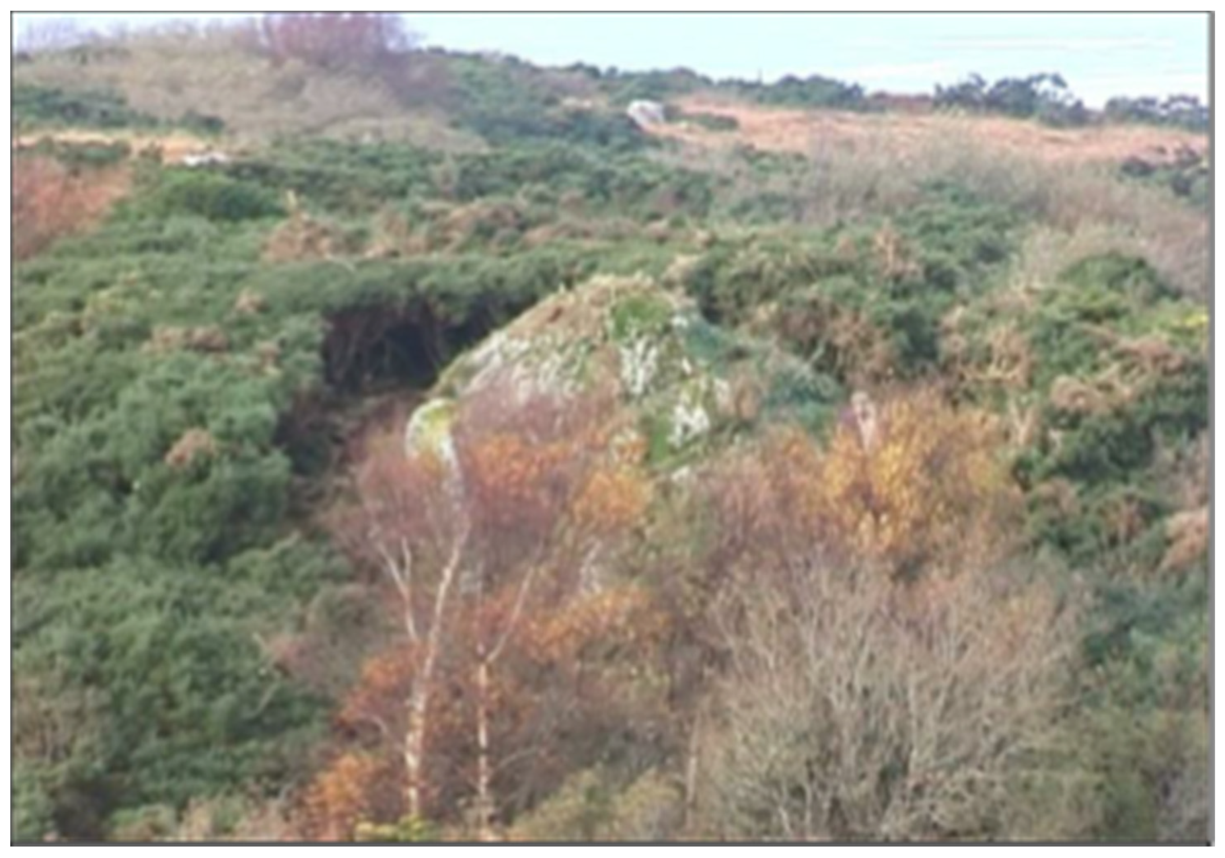
In County Wicklow, south of Dublin (Ireland’s capital city), is a well-known landmark hill called the Sugarloaf, which is a popular amenity spot for family walks at weekends and holidays. The name is used for numerous other similarly isolated conical hills in Ireland, but the important point is that, anecdotally at least, the hill is widely held to be an old volcano. Its shape superficially resembles that of a classic cone-shaped Andean volcano, so it is perhaps not surprising that this weathered Cambrian quartzite peak has been so mistaken, especially since in the Irish education system, Geology or Earth Science has been a negligible component of past school curricula. Although the Earth Science content of the school curriculum has improved slightly in very recent years, there is still a very low level of public awareness of Geology as a science in its own right, or as a foundation component to many other sciences.
It is from this very low base that this contribution is framed, exploring how ancient volcanic rocks and phenomena are presented to the general public across a wide range of geological heritage sites and UNESCO Global Geoparks. The critical point to note here is that the island of Ireland is situated on geologically stable crust, with the opening of the North Atlantic Ocean some 60 million years ago being the last event to leave a volcanic imprint. The Giant’s Causeway, a UNESCO World Heritage Site in County Antrim, Northern Ireland (see
Section 3.3), is the exceptional public face of that significant event. However, most volcanic rocks in the Republic of Ireland (ROI) are much older and have typically been affected by deformation and metamorphism. Apart from the Giant’s Causeway, there are few sites that present obvious volcanic features in the way that a visitor to Mount Teide in Tenerife, Mount Etna in Italy or many other popular holiday destinations with active or recently active volcanoes can experience.
This contribution describes how volcanic geoheritage is being presented and explained in some sites in Ireland (ROI), and how it may be ‘sold’ to the public in other, less obvious places, were there resources available to do so. It is about the stories that can be told to fire the imagination of residents and visitors alike with a vision of past volcanoes at those sites. It is not a systematic review of volcanic sites in Northern Ireland, which has a different legislative scheme for geoheritage sites, (see
Section 2.2), but the Giant’s Causeway has been used to complete the volcanic history of the island of Ireland and to illustrate issues of site interpretation and promotion.
2. Geological Heritage Sites in Ireland
2.1. Ireland’s County Geological Sites (CGS)
Initial approaches to geoconservation in Ireland through the Irish Geological Heritage Programme (Geological Survey Ireland) were described by Parkes and Morris [
1,
2] and further documented in Parkes [
3]. The official status of geological heritage programme efforts was recorded in the ProGEO manual of Geoconservation in Europe [
4]. Original plans for the designation of statutory geological Natural Heritage Areas failed to progress [
5,
6] and County Geological Sites (CGS) have become the only effective current geological heritage site designation in Ireland [
6]. Although non-statutory in character, CGS do receive an effective degree of protection through incorporation into statutory County Development Plans. The inclusion of CGS into statutory County Development Plans and within the planning system means that no significant development may occur without some consultation with Geological Survey Ireland about the site’s geological heritage value. There are no specific restrictions on what a landowner can do in relation to a County Geological Site. Any proposed development that requires planning permissions simply flags the geological heritage interest of the site and allows it to be factored into any decision along with any other competing interests and values.
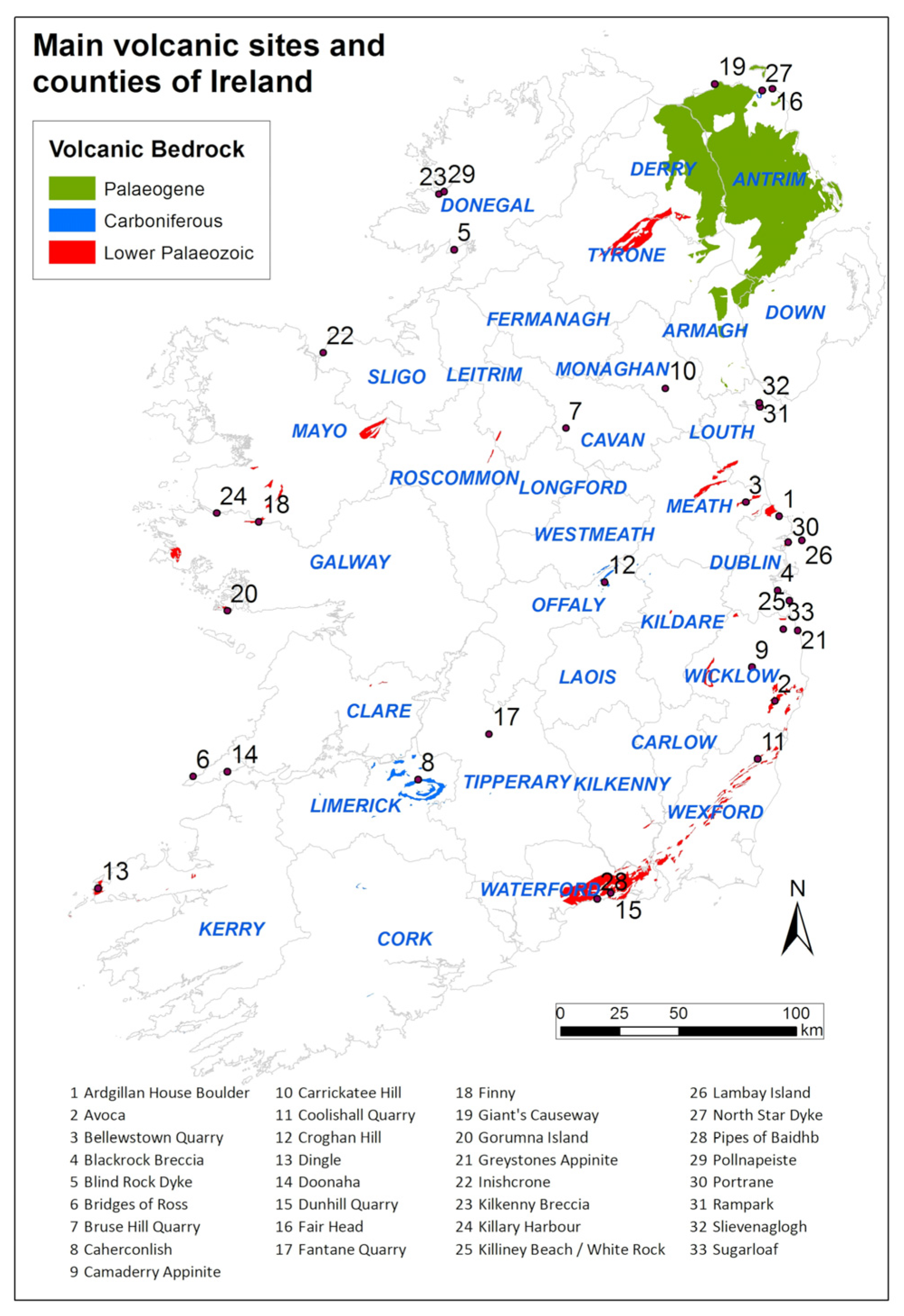
From an initial audit of County Sligo’s geological heritage in 2004 [
7], a programme of county audits has evolved such that after 2020, only three counties, Kerry, Cork and Limerick, remain to be audited (
Figure 1). Whilst there will be a need to revisit some of the earliest audited counties to take account of new geological knowledge, as well as a more expanded view of the CGS criteria applied in the majority of counties, there is already a very good cross-section of volcanic sites identified to provide the examples discussed below.
On the conclusion of a county audit, a geological heritage report on the whole county and individual reports for each County Geological Site (CGS) are published on the Geological Survey Ireland website [
8]. Each CGS report normally has one page of text defining the site and its scientific interest. This page also includes some brief guidance in terms of promotion and management of the site. An additional page of photographs and a page of maps at different scales complete the report. The report provides adequate detail in largely non-technical language for planning professionals in the County Council to use the data in their policies and practice.
The Irish Geological Heritage Programme of Geological Survey Ireland has considered Ireland’s geological heritage under 16 geological themes. Whilst many volcanic-interest sites have been defined as CGS under the IGH11 Igneous Intrusions theme, others fall into the various stratigraphical themes (e.g., IGH4 Cambrian-Silurian, IGH10 Devonian, etc.). Many CGS do of course have an interest across two or more geological themes.
2.2. Northern Ireland’s Areas of Special Scientific Interest (ASSI)
This review covers the volcanic geoheritage mainly in Ireland (ROI). As a part of the United Kingdom, Northern Ireland has its own scheme of statutory ASSIs—Areas of Special Scientific Interest (very similar to the statutory Sites of Special Scientific Interest (SSSI) defined under the Geological Conservation Review in England, Scotland and Wales). There is a range of sites with different interests in Northern Ireland, but in Country Antrim, especially, there are numerous sites associated with the Paleogene volcanism of circa 60 million years ago during an initial phase of rifting related to the opening of the North Atlantic Ocean.
The listing of ASSIs includes 12 sites for Caledonian igneous geology and at least 27 for Palaeogene igneous geology, along with several other igneous sites under other themes. The Earth Science Conservation Review (ESCR) [
9] has also identified numerous other sites that have not yet been designated as ASSIs but which may be in future. The ASSI sites are more integrated as natural heritage sites, with many having biodiversity (plant communities or bird habitats) importance as well as geodiversity. Some are also classified and protected as National Nature Reserves, such as Tardree Quarry, which exposes rhyolite. A review of the many promotional efforts on Northern Ireland’s volcanic sites is outside the scope of this paper but is desirable.
3. Ireland’s Volcanic Heritage
Ireland’s geological heritage stretches back almost two billion years and includes numerous traces of volcanic activity (
Figure 2). Of most significance from a geoheritage perspective are those produced during two periods that saw the closure of one ocean, the Iapetus, and the opening of another, the Atlantic. In between them, the deposition of sediments in the shallow tropical seas of the Carboniferous period was interrupted by a third phase of volcanism, responsible for several significant volcanic heritage sites in Ireland (
Figure 1).
3.1. The Iapetus Ocean: Subduction Zones and Island Arc Volcanoes
The Iapetus Ocean separated the continent of Laurentia, comprising present-day areas of Scotland, the north of Ireland, Greenland and North America, from another large continent to the south, known as Gondwana, and two smaller continents, Baltica and Avalonia. The ocean reached a maximum width of around 5000 km some 500 million years ago before it began to close. Closure occurred over a period of 100 million years and saw the ocean crust subduct beneath the continents, culminating in continental collision. As at tectonic plate margins such as the Pacific Rim today, chains of volcanoes developed above the subduction zones. The volcanic eruptions that occurred as the ocean closed are now part of the volcanic heritage preserved in Ordovician and Silurian rocks on both sides of the former ocean. Continental collision led to the Caledonian orogeny and the intrusion of large volumes of granitic rocks.
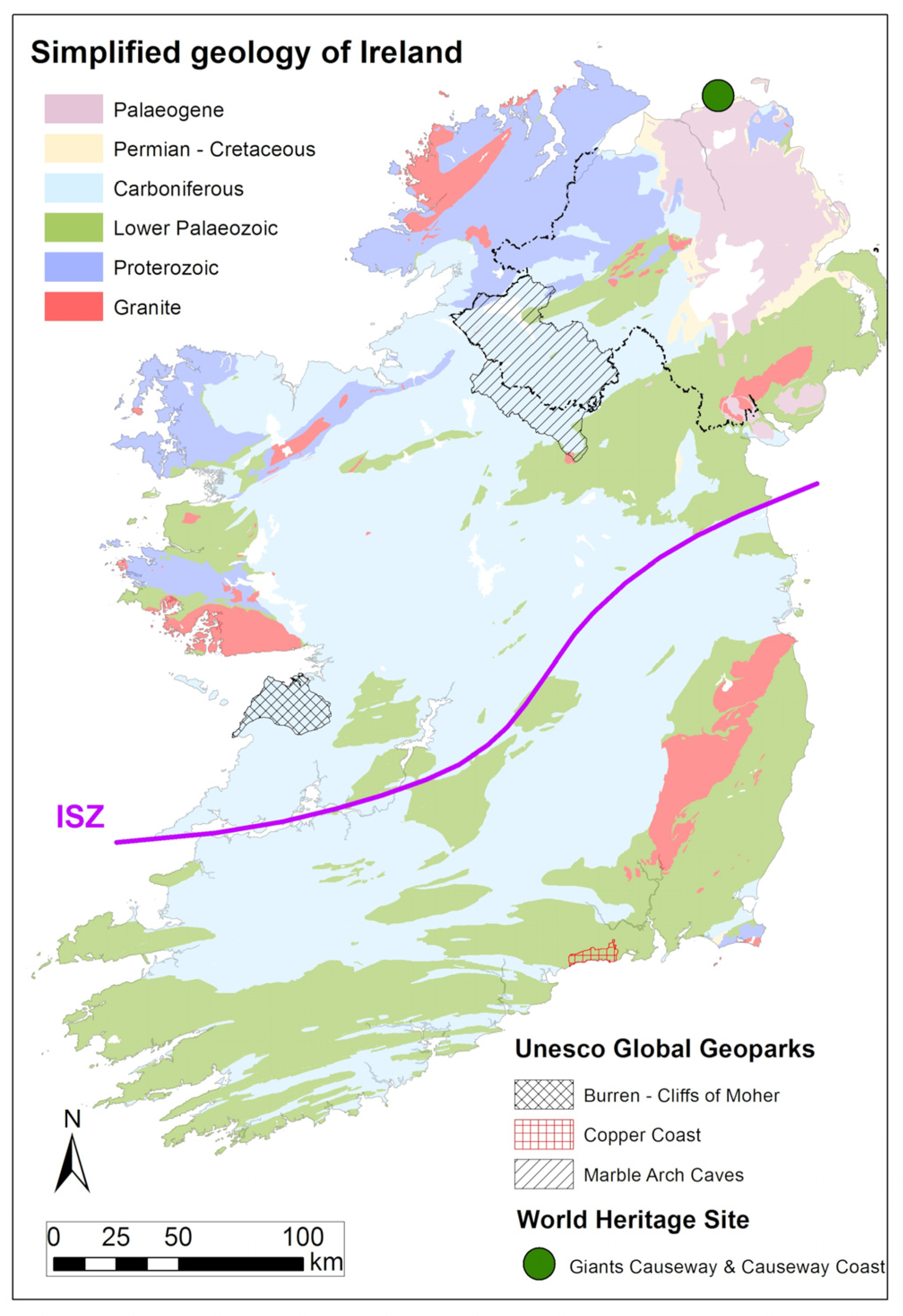
The line of closure, or suture, of the former Iapetus ocean runs northeast-southwest through the centre of Ireland (Iapetus Suture Zone—ISZ,
Figure 2). The volcanic rocks to the north of the suture are found in locations stretching from the east coast to the west coast. Those to the south of the suture occur largely in the east and southeast of the country but can be traced to the west coast.
3.1.1. The Northern Margin of the Iapetus Ocean
The Longford-Down Inlier extends across counties Longford, Cavan, Monaghan and Louth in Ireland and Armagh and Down in Northern Ireland. It comprises Ordovician and Silurian greywackes that were deposited on the Iapetus Ocean floor before being stacked up above the subduction zone as the ocean closed, as well as volcanic rocks erupted from the island arc volcanoes that also developed above the subduction zones. Bruse Hill Quarry in County Cavan [
10] exposes Ordovician green greywackes, red shales and minor spilitic lavas, providing an accessible view of the rocks associated with ocean closure and thought to have been deposited in water depths of over 4000 m. This abandoned quarry is not currently promoted on site for its geological heritage but is cited as part of the ‘Drifting Apart Story’ (see below).
In contrast, Carrickatee Hill in neighbouring County Monaghan [
11] exemplifies some of the difficulty in telling old volcano stories that will capture public imagination and potentially engage them in geoscience, even at a very superficial level. Here, pyroclastic agglomerates are exposed on the sides of a small, wooded hill. They are among possibly the best exposures of Ordovician volcanic rocks in the Longford-Down Inlier. However, Carrickatee Hill is quite remote from any standard tourism sites in the country and does not have other characteristics of heritage value. Aside from any issues of physical access and land ownership, it is arguable that despite the good representation of part of Ireland’s geological history, the complexity of the whole story is quite difficult to simplify for the wider public. Some volcanic stories are more difficult to relate meaningfully and may be better left to geology students and researchers.
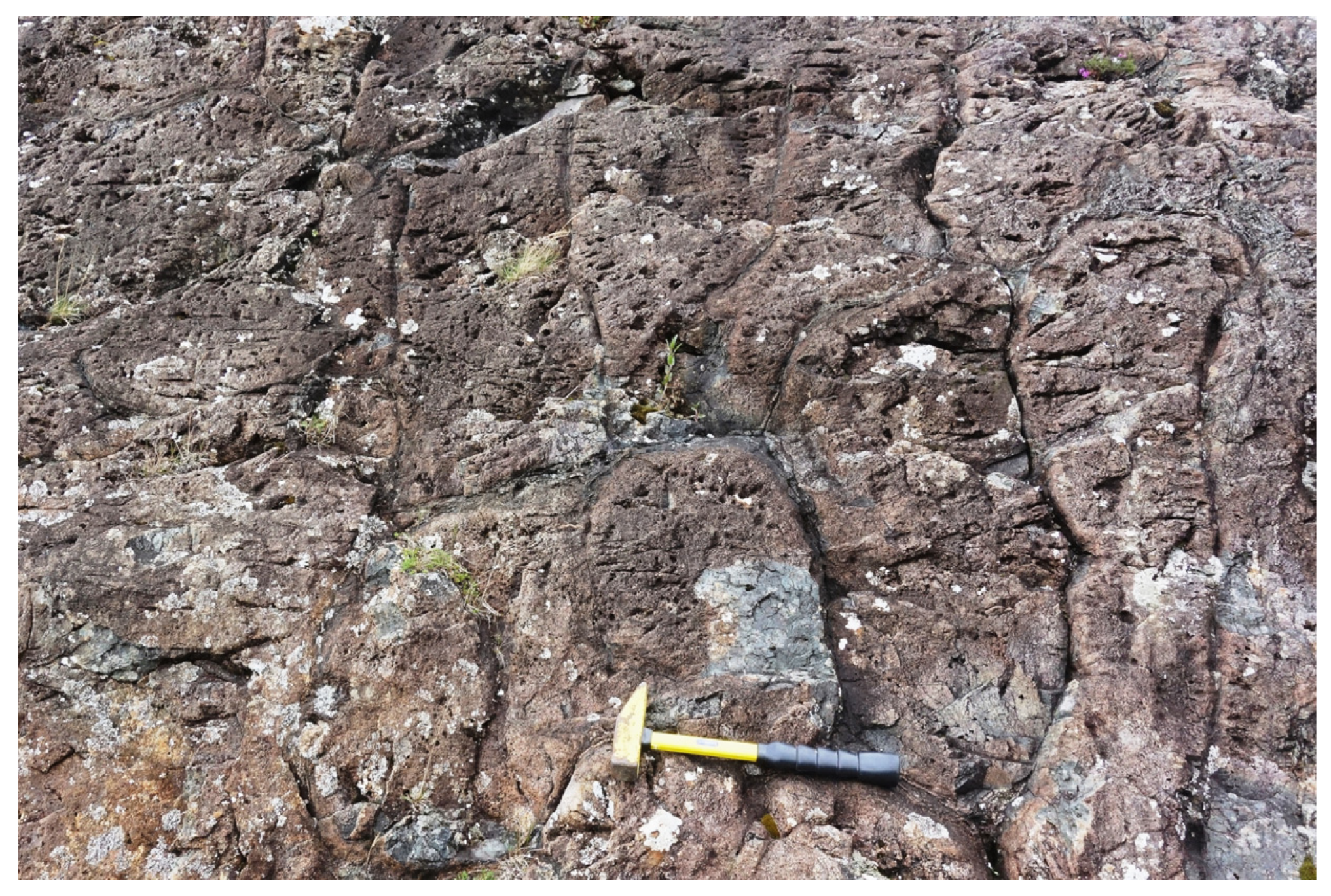
Finny (
Figure 3) is one of the classic stops on geology student field trips in County Mayo [
12]. It displays some easily accessible roadside exposures of Ordovician pillow lavas. These are featured in some geological field trip guides and are an asset for the Joyce Country and Western Lakes geopark project. The shapes of the pillow lavas are sufficiently clear to allow any non-specialist to appreciate that they are tubular lava flows, originally erupted into water, with chilled margins from contact with the water. In addition, adjacent exposures are volcanic agglomerates, adding to the interest in a very small area.
Killary Harbour on the west coast is well known as Ireland’s fjord, and there are numerous other geodiversity interests in and around it. However, there is one place where it would be very easy to tell an exciting volcanic geoheritage story. A small roadcut and roadside quarry near Killary Harbour exposes an Ordovician ignimbrite. Here, the rock itself can be seen close up but when the site is viewed from a distance it is clear that the road cuts through a linear ridge that continues east and west. Further examination shows that on the skyline to the west, there are five prominent ridges. Each of these distinctive landform features is formed by ignimbrite. The whole assemblage is worthy of some interpretation for tourists driving through this popular route. Television images of active pyroclastic flows during volcanic eruptions are perhaps familiar enough to suggest that this would be a good place for visitors to imagine this happening in Ireland some 460 million years ago.
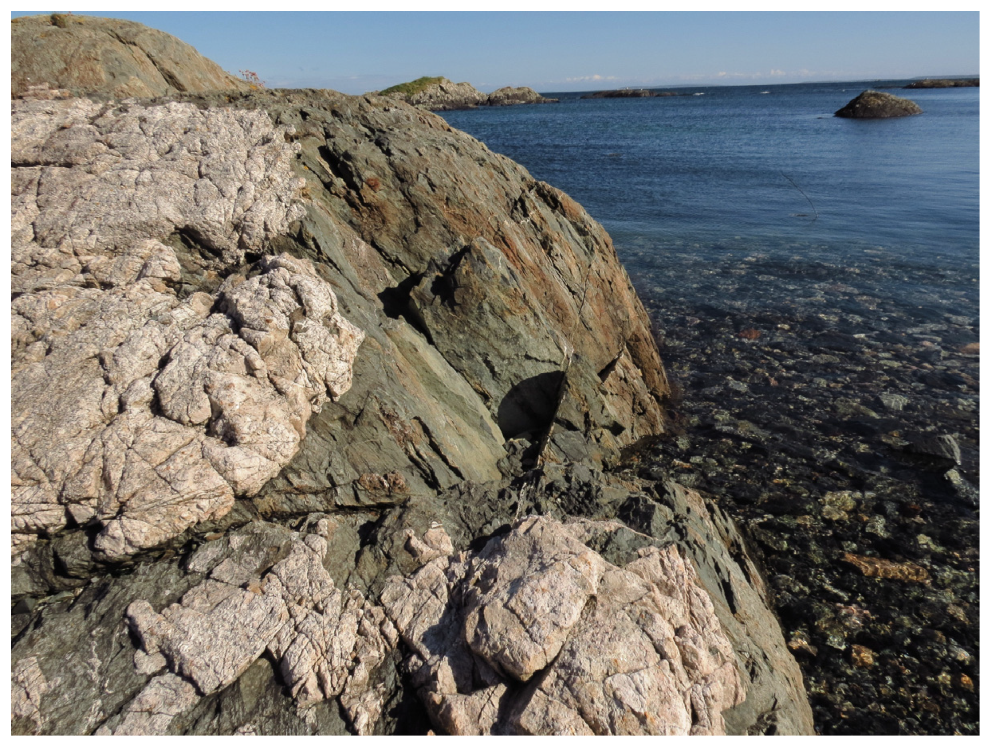
County Galway is one of the most complex and diverse geological areas in Ireland and has many more CGS than most. Of these, there are numerous sites that fall within the Igneous Intrusions Theme (IGH11), with many from the large Caledonian Galway Granite area of south Connemara. However, few of these have been related to volcanic activity and even the quite numerous dyke intrusions in the region are interpreted as being related to late-stage granite intrusion. The one CGS that hosts significant volcanic rocks is Gorumna Island (
Figure 4) [
13], where the well-exposed bedrock comprises a complex sequence of basic volcanic rocks, amphibolite sills and deep-water sedimentary rocks. These are interpreted as having formed in a volcanic arc on the northern margin of the Iapetus Ocean and have been correlated with similar rocks in the Longford-Down inlier. This site, as well as providing relatively rare exposures of volcanic rocks in Galway, also exemplifies how volcanic rocks can contribute to our understanding of large-scale crustal development over millions of years.
3.1.2. The Southern Margin of the Iapetus Ocean
Northeast Ireland (ROI)
One of the easiest single features with which to explain volcanic rocks to the public is found in the grounds of Ardgillan House (
Figure 5) [
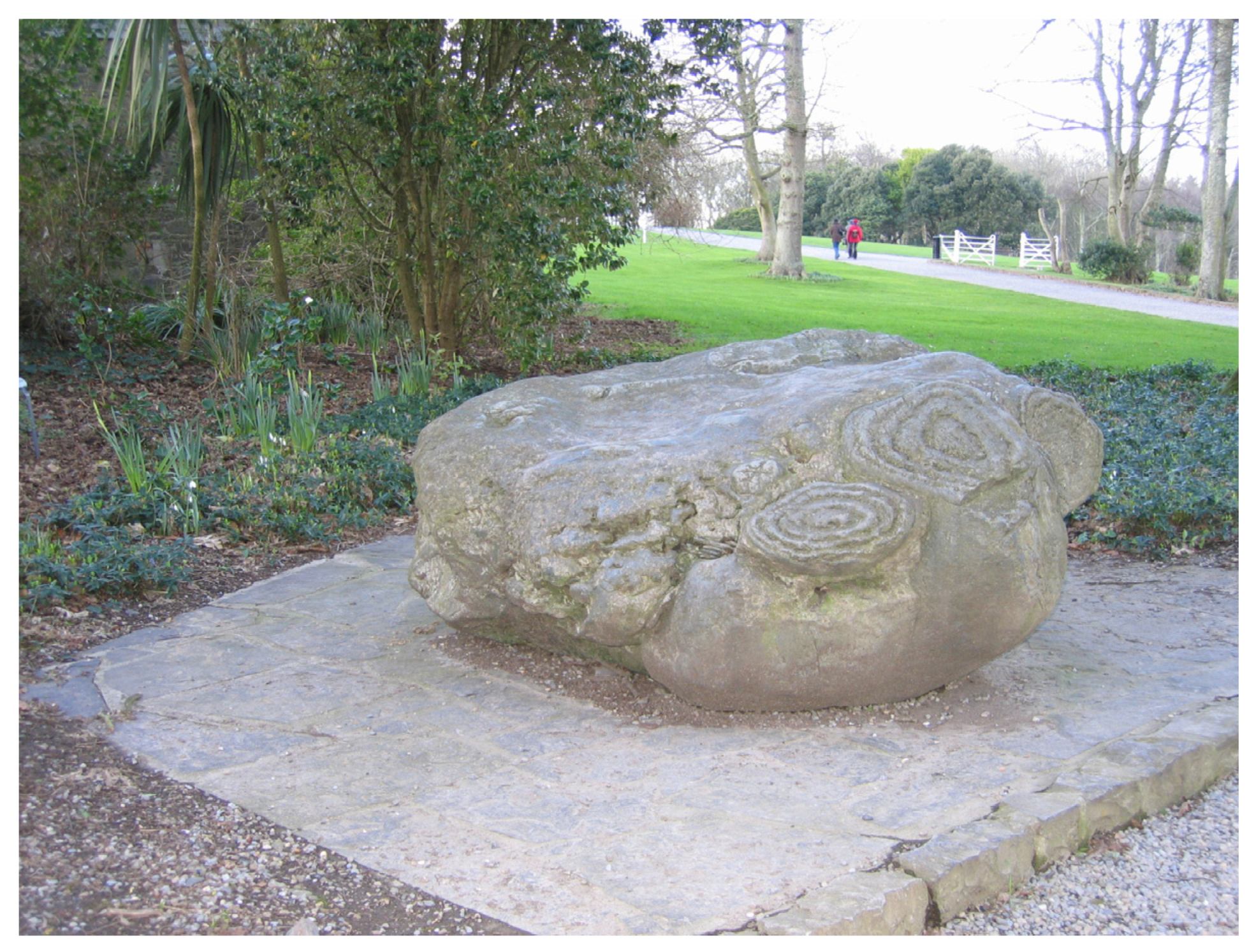
14] on the north coast of County Dublin. The house is owned by Fingal Council and run as a public park and visitor attraction. On the route between the car park and the House is a large boulder which was collected from a nearby beach, in the mistaken impression that its concentric circular patterns were some ancient Celtic carvings. They are in fact the weathering pattern of pillow lavas from Ordovician volcanoes that erupted in the area some 460 million years ago. However, despite suggestions made in the CGS report, no interpretation or explanation is available on site, yet it provides opportunities to tell several fascinating stories in a publicly accessible and eye-catching location. The boulder reveals not only its geological origin as volcanic lava erupted underwater, which is evidence of the closure of the Iapetus Ocean, but also a more recent history of movement at the hands of people.
Lambay Island, situated off the coast north of County Dublin [
14] is the eroded remains of an Ordovician volcano, located on the leading edge of the Avalonian continental plate. Throughout the Ordovician Period, this small continent was moving northwards as the Iapetus Ocean closed. This level of presentation of the geological history of Ireland is comprehensible to ordinary people, and personal experience has shown that many people are fascinated to learn this story, if it is presented well.
Whilst Lambay Island is an understandable story and an important CGS, it presents difficulties too. The island is privately owned and not publicly accessible in general. Therefore, excellent exposures of thin limestone beds with corals draped over andesite lavas, found at the remote eastern tip, are only ever seen by privileged geologists. Furthermore, the island’s somewhat flattened low cone shape, as seen from the mainland, may disappoint those expecting a sight more in keeping with the popular image of a modern volcano.
Fortunately, at Portrane Shore CGS [
14] on the mainland closest to Lambay Island, an excellent coastal exposure reveals most of the same rocks found on Lambay Island or their more distal equivalents, plus slightly younger carbonate rocks. Although access to some features is controlled by the tides, there is always enough of interest visible from the coastal path around the headland, to be able to present the geology through a guided walk or geological fieldtrip. Every degree of understanding can be catered for here, with many levels of detail to be explored, including the limestones and debris flow deposits that overlie the volcanic rocks. Soft sedimentary structures are abundant and their story can be told as one of instability of sedimentary deposits around the former volcano. Whilst the complexity of geology can be investigated and queried by geological field parties, here, there is clear, simple evidence that can be seen, absorbed and understood by a non-specialist visitor. Several simple guides to this CGS have been published and remain popular with local people [
15].
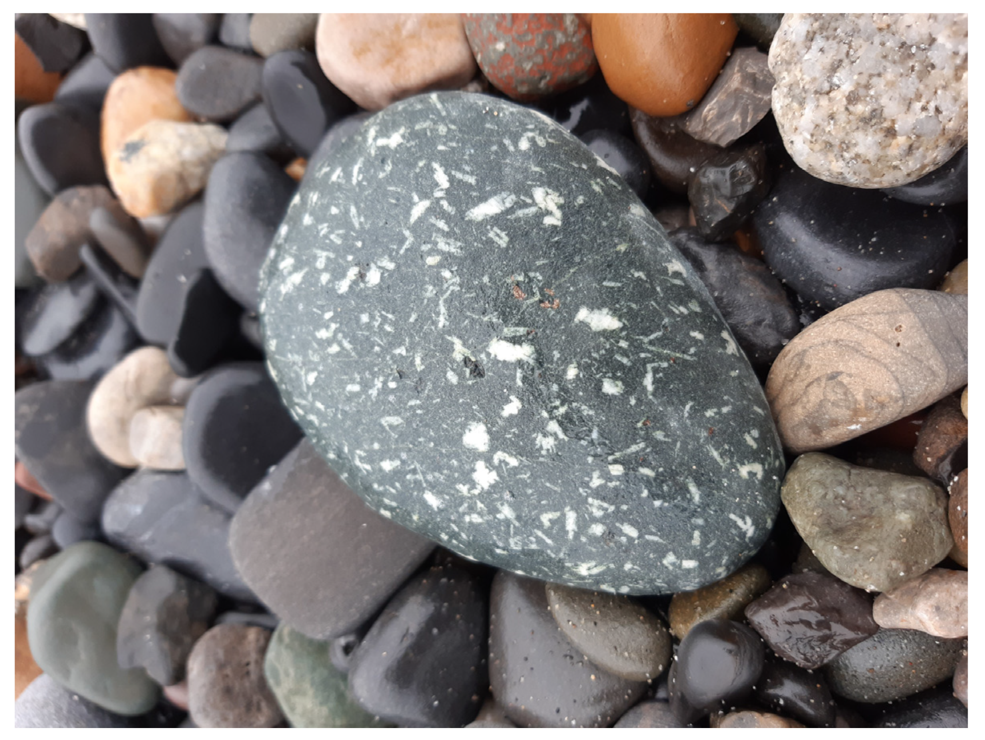
Aside from these sites, pebbles of the distinctive Lambay porphyry (
Figure 6) are common along the east coast of Dublin and in particular on Killiney beach, a popular ‘outdoor classroom’, from where the volcanic stories can be equally well told.
One unique CGS, Bellewstown Quarry in County Meath [
16], exposes an inlier of volcanic and sedimentary rocks that existed as a volcanic island in the middle of Iapetus during Ordovician times. Fossil faunas show affinities with other island faunas whilst younger shales reveal the island had later moved closer to the adjacent continents.
The Kilsaran International operators of this working quarry agreed a formal proposal to permit access for a GSI (Geological Survey Ireland) and NMI (National Museum of Ireland) research team, and their ongoing cooperation has proved a model of best practice for operators of extraction sites of geological heritage importance. Where promotion is not practical in CGS that are working quarries, GSI encourages the inclusion in restoration plans of rock faces left visible and accessible, ideally with interpretation panels and viewing platforms [
17].
Southwest Ireland (ROI)
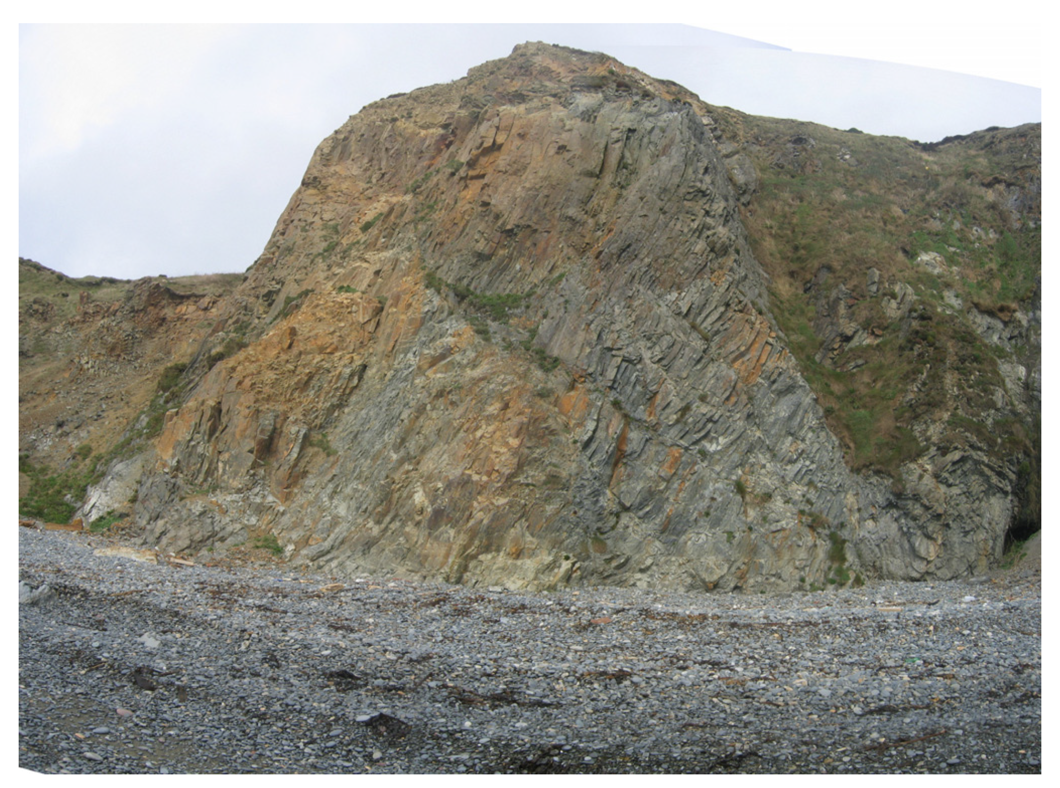
One of the most western occurrences of volcanic rocks south of the Iapetus suture is in Fantane Quarry (
Figure 7) in County Tipperary [
18]. Here, volcanic ash horizons are highly visible as pale green bands against the dark grey Silurian greywackes. The strong folding means they are repeated around fold hinges. However, as with many working quarries, it is not practical to present the volcanic geoheritage to a wider public. In Fantane Quarry, as with other quarries, it would require a specific investment by the quarry operator in public relations to embrace organised visits, such as by school groups, when the stories could be told.
The audit of County Kerry, on the southwest coast, is yet to be completed but some of the potential CGS within the Silurian volcanic rocks of the Dingle Peninsula are given here and more fully addressed in Geological Field Guides such as Meere et al. [
19].
The western end of the peninsula around Clogher Head reveals a sequence of Palaeozoic sedimentary and volcanic rocks accumulated within the small Dingle Basin. Distinctive textures can be seen clearly in the dark green and red volcanic rocks, including sharp ‘glass-like’ shards, forming flattened ‘eutaxitic’ fabrics within fine-grained welded tuffs. These features tell a dramatic story of subaerial porphyritic lava and pyroclastic flows, with hot pumice and ash falling into the lava to become stretched out in their ‘plastic’ state. Later burial at depth compressed the deposit and preserved the pumice fragments as the glass-like shards, known as ‘fiamme’.
In slightly younger rocks immediately to the south, similar but thin, pyroclastic flows in a pre-dominantly red-bed sequence contain volcanic bombs. Adjacent highlands that controlled seasonal flooding and the red-bed deposition are also thought to have been active volcanic centres producing the pyroclastic flows.
Ferriter’s Cove exposes Silurian sandstones and siltstones rich in fossils and interbedded with thin layers of coarse-grained volcanic ash with sharp pale clasts. These are interpreted as pyroclastic flow and ash deposits from a nearby source, reworked in a shallow water environment. An overlying 5 m thick volcanic tuff forms a prominent ridge and indicates a more sustained episode of volcanism.
Southeast Ireland (ROI)
The southeast of Ireland contains the largest extent of volcanic bedrock in Ireland, outside of the Palaeogene of Northern Ireland. The Duncannon Group, a belt of Ordovician felsic and basic volcanic lavas and tuffs, stretches from the east coast in County Wicklow through County Wexford to the south coast in County Waterford. These rocks are products of the volcanic arc that formed on the southern margin of the Iapetus ocean.
On the south coast in County Waterford the Copper Coast UNESCO Global Geopark (see
Section 4) contains numerous CGS that cater to a wide range of geological interests, including Ordovician palaeontology, Quaternary features, coastal geomorphology and significant mining heritage. However, the underlying basis for the Geopark is essentially the Ordovician volcanic succession [
20]. Two examples of specific interest that relate to the volcanic geoheritage theme are the Pipes of Baidhb (
Figure 8) and Dunhill Quarry (
Figure 9) [
21]. The former is an intrusion of rhyolite, seen in the cliffs of Knockmahon and Stage Cove, and accessible to anyone walking along the shoreline. The rhyolite displays columnar jointing, reminiscent of the Giant’s Causeway. The intrusion was named by Des Cowman, a local leading light in the inception and development of the Geopark, as part of a deliberate strategy to promote the Geopark’s assets through its folklore. The ‘Baidhb’ was a ghostly woman, wandering the local roads and screeching an omen of death that echoed from the organ pipes in the cliff.
Dunhill Quarry would be an especially interesting site for public presentation, if the necessary permission and access arrangements could be negotiated. Although presently partly overgrown with vegetation, the face of this quarry displays at least five individual tuff units in a face that looks like it was sawn with a cheese wire. The top of each unit comprises laminated fine-grained tuff with the remainder composed of coarser grained lapilli tuff. The quarry faces display larger blocks of volcanic material that fell directly to the ancient sea floor, indenting the surfaces of the tuff layers. Some units have pumice fragments that were deposited on the top of the layer before eventually sinking after becoming waterlogged. Some good interpretation on site could make this a very visual, safe and easily understood access point to the geological story of Ordovician volcanoes on the Copper Coast.
In County Wexford, the large working quarry at Coolishall [
22] excavates a large rhyolite body, representative of many such volcanic bodies that comprise the Duncannon Group volcanics of SE Ireland. These resistant volcanic bodies form the core of numerous small hills that stretch from County Wicklow to New Ross in southwest County Wexford. Whilst there are many other concerns for an operator to address in the simple process of operating a quarry, it would be highly beneficial if some level of controlled public access were made possible, especially for educational groups. Not only would this enable school children to learn a little about the ancient volcanic history of County Wexford, but it would also teach them about the importance of quarrying to maintaining the lifestyles we currently enjoy in our societies.
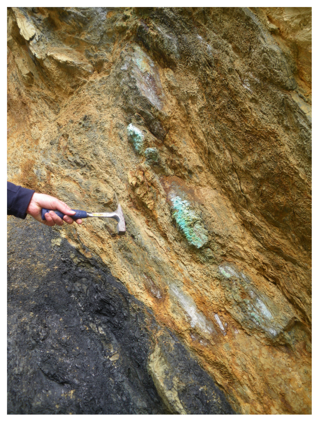
Volcanic rocks contain some of the world’s most important mineral deposits and are particularly associated with copper and gold. The Ordovician volcanic rocks of the Avoca district (
Figure 10) in County Wicklow [
23] hosted a large massive sulphide deposit and Ireland’s most important copper mine. Historical (18th and 19th century) mining in adits and shafts was overprinted by 20th century underground and open pit mining. The mines finally closed in 1982. Large open pit mining has left a significant geoheritage legacy, with excellent exposures of both mineralisation and the volcanic host rocks, as well as iconic Cornish engine houses.
However, Avoca exemplifies some of the difficulties of promoting geological and mining heritage in competition with other viewpoints. Although Avoca’s mining and, by extension, volcanic geological heritage has been the focus of multiple community driven projects to conserve and promote it, with a view to becoming a National Mining Heritage Centre, the site is in state ownership. The state body responsible for management of the site has largely focused on safety issues and on addressing the significant environmental contamination caused by discharge of acid mine drainage from the site. There has been little room for public promotion of mining heritage in recent years.
3.2. The Carboniferous: Tropical Seas and Underwater Volcanoes
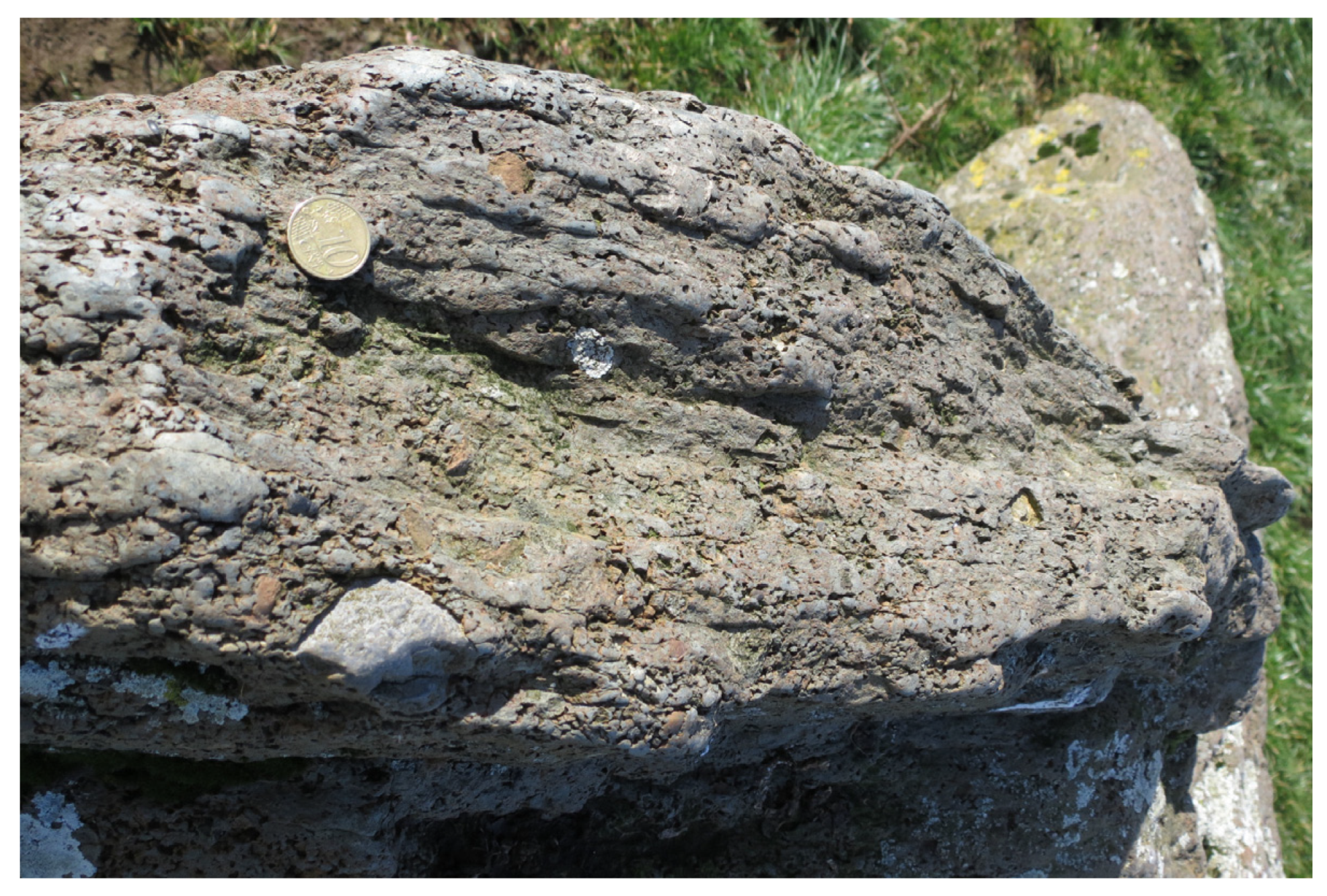
Croghan Hill (
Figure 11) is the remains of an extinct volcano that erupted and emerged from the sea that covered County Offaly [
24] and much of the rest of Ireland during the Carboniferous Period. A variety of volcanic rocks occur on and around Croghan Hill, including alkali basalts, limburgites, pyroclastic agglomerates and tuffs. The rocks are interbedded with the limestones that formed in the warm seas into which the volcano erupted. These rocks record episodes of lava flows and violent explosive eruptions. On the northeastern side of Croghan Hill, some columnar jointing in basalt, formed by a similar process to that in the Giant’s Causeway, suggests ponding and cooling of the lava in a subaerial environment. Gneiss xenoliths have been described [
25,
26] in agglomerate to the west of Croghan village and in basalts south of the village. It has been suggested that these high-grade metamorphic gneisses are derived from the sub-Palaeozoic lower crust in this region. There is a great scope for making more of the old volcano story at Croghan Hill and this should be made easier by the fact that the official tourism Discover Ireland website refers to it in one of its headlines as an old volcano.
County Limerick contains the most extensive development of Carboniferous volcanic rocks in Ireland, part of the Limerick syncline. Extensive ash deposits or tuffs, of basaltic origin, are interbedded with limestone and are in places fossiliferous, evidence of deposition in a shallow tropical sea. Basalt lava flows are also present and in one quarry at Caherconlish a trachyte body displays spectacular columnar jointing. The GSI Public Data Viewer for unaudited sites [
27] shows 11 provisional CGS of volcanic interest, some of which have great potential as volcanic geoheritage sites. The area is the subject of several classic geological descriptions, including Lamplugh et al. [
28] and Geike [
29], but has yet to be surveyed in modern times as part of a CGS audit. Thus, information on the current status of the sites is lacking.
3.3. The North Atlantic: Basalt Lavas, Columnar Jointing, Dolerite Dykes and Cone Sheets
The North Atlantic began opening around 200 million years ago and the ensuing period of crustal rifting eventually led, 65 million years ago, to the creation of the Palaeogene North Atlantic Igneous Province. Then, large volumes of magma were intruded into the crust or erupted through fissures. Traces of Palaeogene volcanism can be found as far south as Dingle in County Kerry but the most important examples are in the northern part of the island. The Giant’s Causeway is the most spectacular example of thick basalt lava flows that covered much of the northern part of the island. The lava flowed upwards through fissures, now preserved as a series of dolerite dykes that extend westwards into today’s Atlantic. Large volumes of magma solidified underground to form granites and gabbros.
3.3.1. The Giant’s Causeway, Geoheritage Interpretation and Visitor Experience
With just under 1 million visitors in 2019 [
30], the Giant’s Causeway World Heritage Site (WHS) in north County Antrim (
Figure 12) is one of the most popular tourist destinations in Northern Ireland and one of the best sites anywhere for viewing volcanic geological heritage. The columnar jointing in the basalt flows is probably its best-known feature but the entire site contains numerous volcanic features of interest. Two thick basalt lava flows are exposed in the cliffs above the shore and between them is the Interbasaltic Formation, a red clay (laterite) formed by tropical weathering of the top of the first lava flow. With 40,000 basalt columns, the distinctive structures are likened to classical architecture, with the most accessible colonnade/entablature junction known as ‘The Organ’. The polygonal columns have resulted from the ponding of thick individual lava flows in river valleys cut into the Lower Basalt landscape.
Several authors [
31,
32] have documented the spectacular features and geological significance of the Giant’s Causeway, and the challenges of implementing a management plan, as required by WHS reporting [
33], for this complex geosite. It is also a dynamic site, subject to ongoing coastal erosion and slope failures, which resulted in the closure of the lower coastal path in the mid-1990’s [
34,
35]. A 2010 study [
34], establishing a database of baseline slope instability and future recording mechanisms, has provided a tool for sustainable management in response to the effects of climate change, as well as proposing innovative choices for virtual tourism experiences.
The WHS is promoted through a state-of-the-art visitor centre, opened in 2012. Historically, interpretation and the tourism experience focused on the aesthetics of the basalt columns, woven in with tales of Irish mythology, which overshadowed its geoscientific significance. Folklore legend of the Giant Finn McCool (Fionn mac Cumhaill) invokes the basalt polygons as his stepping-stones between Ireland and Scotland and likens a range of volcanic features to possessions, such as ‘The Giant’s Boot’.
In response to this imbalance, a 2007 survey [
36] to assess visitor appreciation of the site’s geoheritage value and on-site interpretation showed a relatively limited understanding of its abiotic nature (as opposed to its biodiversity). The recognised need for improved geoheritage interpretive panels and interaction through guided walks were some of the conclusions that also had relevance for other (particularly coastal) geotourism sites. While there is a valid place for folklore ‘enhancement’ at geosites, there is still a need to fully redress the balance at the Giant’s Causeway and to promote the dramatic geological story. Guided walks are now available, although individual ranger guiding and interpretation may be variable in its myth–science balance.
The WHS management plan has also required a balance between promotion and geoeducation, and geoconservation: a dilemma that is not to date necessitated by the lesser known, older, volcanic sites in Ireland (see
Section 4.1). The wider subject of how to convey the geoheritage message in public-friendly language, rather than technical, and how to produce highly engaging interpretative panels through optimal content and location, has been discussed recently by several authors, for example, by Bruno and Wallace and Brilha [
37,
38]. A summary of existing and proposed interpretative and promotional methods for Ireland’s main volcanic sites are given in
Table 1.
There are numerous other sites along the north Antrim coast where Palaeogene volcanic heritage can be seen. Examples include the North Star Dyke at Ballycastle, a probable feeder dyke for the basalt lavas, and two dolerite sills emplaced horizontally into Carboniferous strata to form the promontory at Fair Head.
However, while the fame of the Giant’s Causeway can be seen as reflecting the popularity of volcanic geoheritage, it can also have the effect of overshadowing other, equally relevant geoheritage stories. The Interbasaltic Formation red beds were extensively mined for iron and aluminium, especially during World War 1, leaving a rich mining heritage in the Glens of Antrim. The direct connection of a cultural and economic heritage to the essential geology underfoot should be easy to promote but, in contrast to the international attention focused on the Causeway (for example, the hobby website ‘Volcano Hotspot’ [
39]), there has been only very limited local interest in the history and physical heritage of the mining industry in the Glens of Antrim.
3.3.2. Palaeogene in Counties Louth, Donegal and Sligo
Further south, County Louth has a multitude of Palaeogene igneous CGS, largely within the Cooley Peninsula around Carlingford. The rocks in these sites are part of a wider development of intrusive and extrusive igneous rocks that includes the Mourne Mountains Granite and Slieve Gullion Ring Dyke complex in County Down in Northern Ireland. Some years ago, local bodies in both jurisdictions together commenced a cross-border Geopark project but after County Louth’s withdrawal, the Geopark endeavour is currently restricted to Northern Ireland and has gone forward as an application from within the UK.
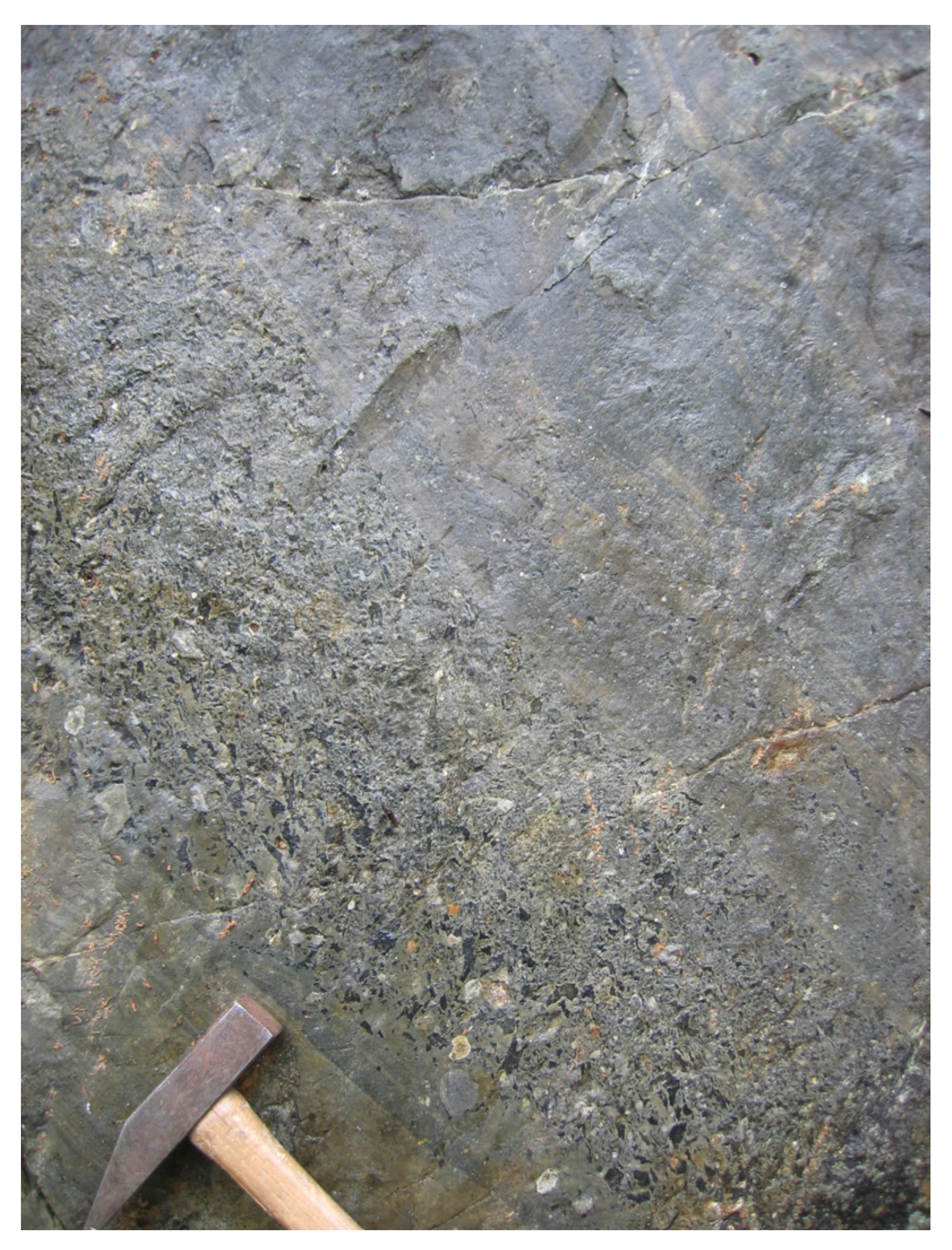
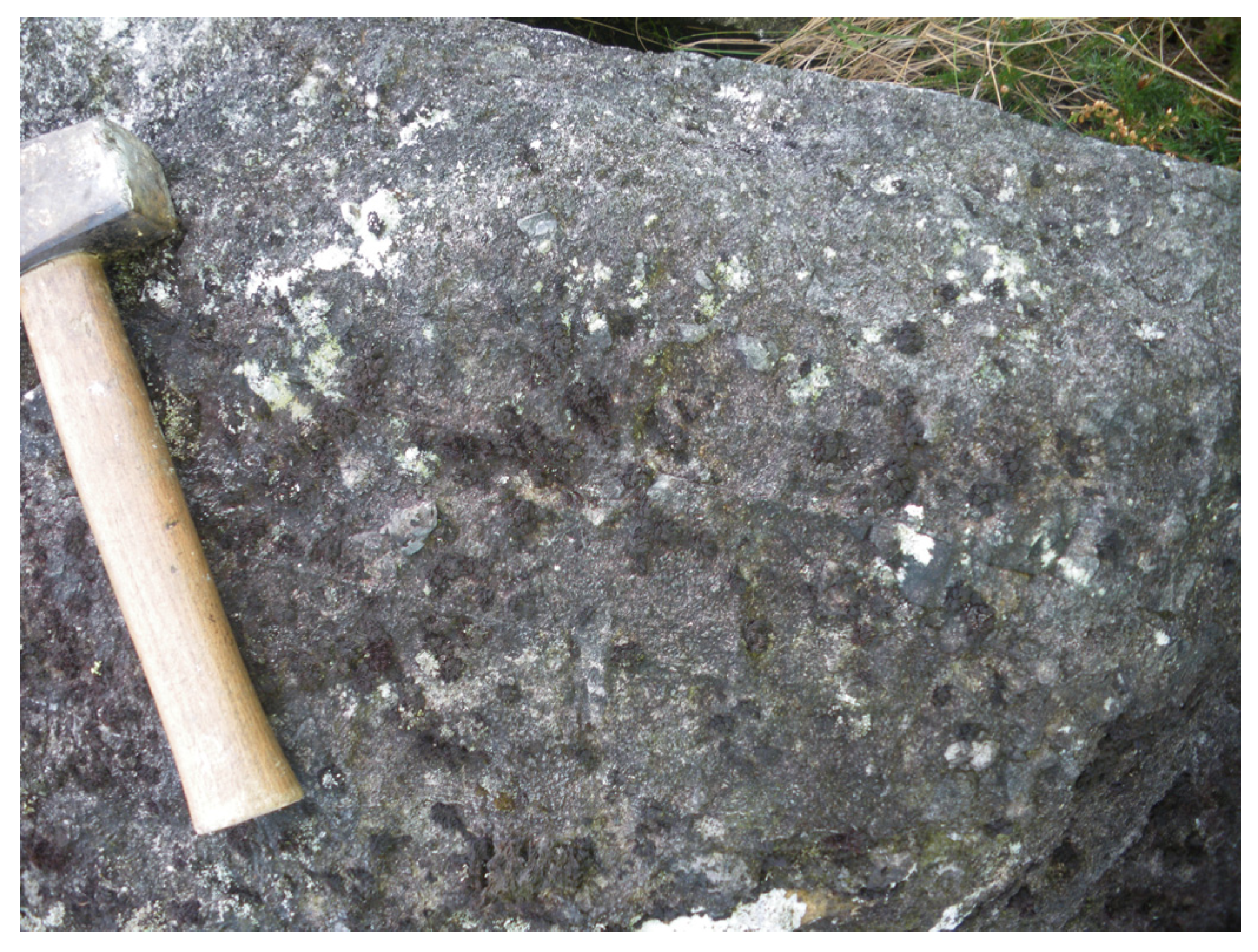
However, there is still much potential for telling volcanic geoheritage stories in County Louth. Most of the relevant volcanic or sub-volcanic sites are of gabbro or granite intrusions, dolerite dykes and cone sheets, but there are also exposures of volcanic agglomerates at Slievenaglogh CGS (
Figure 13) and hawaiite lavas at Rampark CGS [
40]. An excellent field guide for geologists has been published by Baxter [
41], but there is great scope for a more integrated heritage trail for ordinary hillwalkers or cyclists as well as motorists. The visible geology identified in the CGS could be presented in a simple but meaningful way for those untrained in geology, but curious about the natural landscape.
County Donegal has some of the most complex geology in Ireland, dominated by Precambrian Dalradian metasediments and Caledonian granite bodies that were emplaced along major crustal faults. Purely volcanic features are relatively few but new airborne geophysical mapping by Tellus [
42] shows that the northwest–southeast-trending Palaeogene dolerite dyke swarms that are a prominent feature of the Antrim basalt plateau extend across Donegal and into the Atlantic seabed. A notable example is the Blind Rock sub-vertical dolerite dyke on Doorin Point peninsula [
43]. It is interpreted as a composite feeder dyke that supplied now eroded, formerly overlying volcanic rocks, in several pulses of intrusion during the opening of the North Atlantic Ocean. Fittingly, the main exposure of the dyke extends into the Atlantic Ocean in Donegal Bay. Blind Rock is easily accessible and is the best exposure in Ireland of this type of composite dyke. The audit recommends its wider promotion through a visitor information panel.
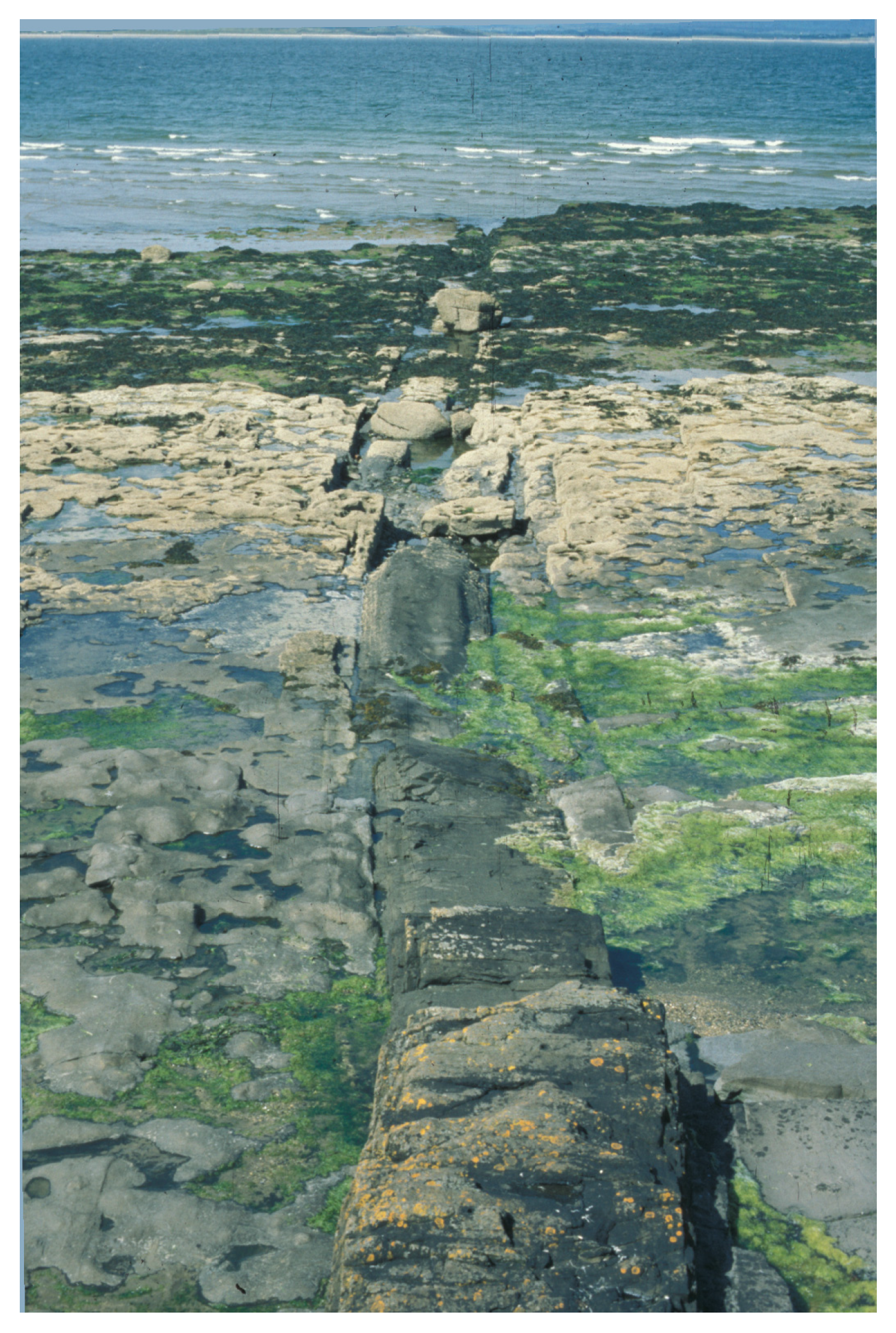
Equally impressive are the very fine exposures of Palaeogene dykes at the eastern side of Inishcrone beach in County Sligo (
Figure 14) [
7]. They feature in a public guide to the geological heritage of the county [
44], which was the first guide derived from an original CGS audit. The site has its own chapter heading, ‘Molten magma rises through the Rocks’, giving context to the dykes. The dykes are numerous on the foreshore, immediately below a popular promenade and traditional seaweed baths. Their form varies considerably with positive and negative relief compared to the Carboniferous Limestone host rock. There are quite variable degrees of baking of the host rock and chilling of the dyke margins and attractive colour contrasts, such that a natural curiosity as to their form and origins ought to be expected. There is certainly scope for more effort to promote them as an interesting feature of the town for visitors.
4. UNESCO Global Geoparks in Ireland
There are currently three UNESCO Global Geoparks in Ireland, the Marble Arch Caves, the Burren and Cliffs of Moher and the Copper Coast. The Marble Arch Caves in County Fermanagh [
45] formed the focus of the first cross-border UNESCO Global Geopark (between County Fermanagh in Northern Ireland and County Cavan in the Republic of Ireland). The Copper Coast UNESCO Global Geopark [
46] is a community driven venture, designated in 2001, and focused on an historic copper mining area of County Waterford in SE Ireland.
There are aspiring Geoparks in other areas, but the Joyce Country and Western Lakes geopark project [
47] is the most likely to meet the stringent requirements for UNESCO approval. Although there are some Ordovician volcanic elements in the district, they are only one aspect of the multiple geodiversity interests here. Another cross-border project that sought UNESCO Global Geopark status for the Mourne Mountains and Ring of Gullion in Northern Ireland, and the Cooley Peninsula in Ireland was unsuccessful. More recently, Mourne Gullion Strangford Aspiring UNESCO Global Geopark [
48] has applied for this status, based on the igneous geology and volcanic geoheritage of the Northern Ireland part of the story. The Antrim geopark project in Northern Ireland is focused on the Palaeogene volcanics and older rocks of the spectacular Causeway Coast AONB and Antrim Coast and Glens AONB (Areas of Outstanding Natural Beauty) [
49].
The Copper Coast UNESCO Global Geopark, based on Ordovician volcanic geology and associated copper deposits, clearly has the most scope for presenting volcanic geoheritage stories to the wider public. Two examples of specific interest were described above, but there are many more potentially available, especially with the facility of the visitor centre in Bunmahon and a dedicated geologist working on public activities.
In the Marble Arch Cave UNESCO Global Geopark, the geological emphasis is on Carboniferous rocks and the upland bogs and karst developed on them. Volcanic rocks do not play any significant part, other than a Palaeogene dyke that crosses Cuilcagh Mountain and plays an influential role in the development of the numerous cave systems, acting as a divide to drainage systems. Whilst this is well known to cavers and influences their systematic approach to cave exploration and dye tracing of water, the dyke is a minor story within the scope of the Geopark and the geological stories they communicate to the many visitors.
4.1. National and UNESCO Global Geoparks
Examples of how to promote palaeovolcanics in geotourism, where storytelling is difficult to relate to a volcanic morphology that has been largely eroded, have been given in several papers on European national and UNESCO Global Geoparks [
50,
51]. These include the extensive Permian lavas and ignimbrites of national Geopark Porphyrland in Germany [
50], where the vast majority of geosites address volcanism as the main theme, which is also promoted through its volcanic stone industry heritage, thematic trails, publicly accessible disused quarries and guided tours. Bohemian Paradise UNESCO Global Geopark (northern Czechia) [
50] explores its volcanic mineralogy theme with a museum dedicated to mineralogy.
Younger volcanic rocks are easier to promote, with their easier to understand geomorphology. The abandoned Hegyestű quarry in Bakony–Balaton UNESCO Global Geopark in western Hungary [
51] shows a nearly 30 m-high wall of columnar jointing in basalt. The Geopark also plans to incorporate a 260 m tunnel carved into Mio-Pliocene volcanic rock at Kopasz Hill, into its Visitor Centre. Columnar jointing is also the focus of some very important geotourism sites around the world, on a par with the Giant’s Causeway, such as the Hong Kong UNESCO Global Geopark, where geotourism, geoconservation, geoeducation and recreation has been successfully integrated in this volcanic setting (e.g., [
52,
53]).
4.2. Drifting Apart Project
Between 2015 and 2018, Ireland, principally through the Causeway, Coast and Glens Heritage Trust and Marble Arch Caves UNESCO Global Geopark, was involved in a Northern Peripheries and Arctic Area Programme ERDF-funded project called ‘Drifting Apart’ [
54] in which numerous UNESCO Global Geoparks and aspiring geoparks on the Atlantic seaboard promoted their shared geoheritage. Much of this related to Palaeogene volcanism, and resources created in the project remain available on the project website for future use.
5. General Issues with Promoting Igneous Geoheritage to the Public
The sites we have described above have been restricted to those showing volcanic rocks sensu stricto and are mostly found under the Geological Heritage Programme’s IGH11 Igneous, IGH4 Cambrian-Silurian, IGH8 Lower Carboniferous and IGH10 Devonian themes, although many CGS having an interest across two or more themes.
However, there are blurred boundaries in geological definitions and in terms of public perception, and there are many sites of a broad igneous nature that can help in demonstrating fundamental principles of geological processes, such as magmatism and chronostratigraphic timelines, to the general public. This blurring can be seen with the strictly-speaking intrusive feeder dykes (e.g., North Star Dyke and Blind Rock) associated with the extrusive Palaeogene lavas.
There are some sites of breccia pipes, appinites and explosion breccias that, although not strictly volcanic in origin, do demonstrate ‘volcanic-type’ mechanisms of upward pipe-like explosive gas and magma intrusions.
Breccia pipes are associated with a suite of Caledonian Appinites that was intruded immediately before the earliest Donegal granite plutons. They were formed through explosive pressure from upward-streaming gas-rich magma, causing fragmentation of the country rock. However, most Donegal sites, such as Kilkenny Breccia Pipe (
Figure 15) [
43], are largely inaccessible (remote, rough ground and/or private farmland) and most likely only of student and specialist interest.
Two County Wicklow sites [
23] with good public access contain Caledonian appinite intrusions. Whilst geological researchers are still working to fully understand these pipe-like intrusions of hornblende rich basic magmas, the simple story can be told that they are coeval basic magmas differentiated from the batholiths of Leinster Granite which dominate this county. Whilst signboards are too intrusive a medium for the Camaderry Appinite in its remote hillside setting overlooking Glendalough, there are other media that could be used (such as geotourism-walking apps), and especially by the hillwalking community who would be the ones passing through exposures on popular walking routes. The Greystones Appinites are along the seafront and could be explained with a signboard to enhance interest for a variety of visitors.
In south County Dublin (Dun Laoghaire-Rathdown) the Blackrock Breccia (
Figure 16) [
55], which occupies a distinctive small area (approximately 30 m by 13 m) in the intertidal zone at Blackrock village, is an explosion breccia, composed of angular fragments of granite set in a matrix of finely broken granite. No junction or boundary with another rock type is seen. The rock is interpreted to have formed in the later stages of the intrusion of the Leinster Granite when an upsurge of an explosive gas phase fragmented granite that had already formed. It is included in some popular guidebooks but there is much more potential to tell the story of this rock which is immediately beside the coastal path. Constant washing by the sea keeps the exposures free of algae, seaweed and other material.
5.1. The Obscure and the Over-Exposed!
So much of the effective promotion of any type of geoheritage depends on easy access for the visitor and the ease with which a guide (in person or by leaflet, app, etc) can point out the features and bring the geological story to life. Two very different sites, at Pollnapeiste in Donegal [
43] and at White Rock in County Dublin [
55], demonstrate contrasting aspects of public accessibility.
Pollnapeiste, is an unusual cave formed in Dalradian marbles, near the mouth of the Gweebarra River near Lettermacaward. The development of the cave has been strongly controlled by the folded amphibolite dykes within the marbles, as they act as impermeable barriers. Since the cave requires rope access to enter, it is a really strong example of just how inaccessible some geological heritage can be to a broader audience, both conceptually and physically.
By contrast, there is a small area of coast at the north end of Killiney Bay that provides interesting geological stories related to igneous rocks but which also exemplifies some of the complexity of promoting geological heritage in competition with other interests. At White Rock, geological students have long been brought to examine the contact between the Dalkey Granite body and the country rock. These metamorphic schists with large andalusite crystal growths are an excellent place to study contact metamorphism by a large igneous intrusion. There is additionally an historical lead mine associated with mineralised fluids from the intrusion. The access to the site is only by one steep path across a railway line. However, the secluded cove at the start of this section has become an unofficial naturist beach in recent years, with sunbathers reclining against the same rocks geological students would wish to examine!
Such sites displaying igneous rocks also highlight the difficulty in bringing to life hard-to-imagine scenarios of huge >600 °C magma chambers of molten liquid rock when gazing upon a weathered bit of cold inert grey granite in County Dublin. Parallels drawn with modern-day volcanoes and the luminous red- and white-hot lavas of Iceland or Hawaii perhaps help in evoking this type of geological image.
5.2. Small Scale Models
As illustrated at the start of this review, the County Wicklow Sugar Loaf’s morphological imitation of a volcano is misleading and is only noted for its cone-like ‘volcanic’ shape.
However, there are small-scale cone-like structures in County Clare that at least have been produced by a process of upward extrusion, albeit in a sedimentary context. These impressive ‘sand volcanoes’, which are only one to two metres in diameter, are found within Upper Carboniferous slumped and deformed siltstones and sandstones at the Bridges of Ross and at Doonaha [
56]. They were formed by the extrusion of fine-grained sediment suspended in water as the sediments were compacted. Featured in a guide derived from the CGS Audit [
57], they offer great opportunities for exploring the topic of volcanoes on a miniature scale, in an easily-accessible and fun way.
6. Conclusions
It is generally accepted that many people are interested in the phenomena of volcanoes and volcanic eruptions for a wide variety of reasons. Many classic tourist destinations actually consist of active or extinct volcanoes and related phenomena. Continuous visitor numbers at accessible volcanoes demonstrate this fascination with the natural world and the enormous power of volcanic phenomena. Based on the unsubstantiated premise that this interest could extend to ancient volcanic rocks and features, in a terrain such as Ireland’s where volcanism ceased many millions of years ago, this review has assessed what volcanic (and broader igneous geology) heritage sites are identified. It has tried to appraise what efforts have been made or are currently in progress to promote the stories behind these sites, as summarised in
Table 1. Clearly in some locations, such as the Copper Coast UNESCO Global Geopark, volcanic rocks and processes are being actively promoted in the core messages of the Geopark. However, in more cases than not, there is little current promotion, and little telling of these old volcanic stories. This review has presented numerous examples to support the view that there is great potential for helping more people to understand the evidence for old volcanoes spread across Ireland.
Author Contributions
All authors (M.P., S.G. and V.G.) contributed to the different parts of the article. All authors have read and agreed to the published version of the manuscript.
Funding
This research received no external funding.
Institutional Review Board Statement
Not applicable.
Informed Consent Statement
Not applicable.
Data Availability Statement
Acknowledgments
The authors would like to thank Michael Dempster (Northern Ireland Environment Agency) for helpful comments on the original manuscript and Eamon Doyle (Burren and Cliffs of Moher UNESCO Global Geopark) for useful clarification on County Clare sites. We are grateful to Brian McConnell for the photograph of the Finny pillow lavas. All observations, data and photographs, except where otherwise stated, are based on CGS audit reports completed as part of GSI’s Geoheritage Programme and published on its website. We especially acknowledge the generous endorsement of Michelle Parkes-Davern in allowing us to complete this paper on behalf of her husband, and our dear friend and colleague, Matthew Parkes, who died unexpectedly in October this year.
Conflicts of Interest
The authors declare no conflict of interest.
References
- Parkes, M.A.; Morris, J.H. The Irish Geological Heritage Programme. In Towards the Balanced, Management and Conservation of the Geological Heritage in the New Millennium; Barettino, D., Vallejo, M., Gallego, E., Eds.; Instituto Tecnológico GeoMinero de España: Madrid, Spain, 1999; pp. 60–64. [Google Scholar]
- Parkes, M.A.; Morris, J.H. Earth Science Conservation in Ireland: The Irish Geological Heritage, Programme. IJES 2001, 19, 79–90. [Google Scholar]
- Parkes, M.A. A history of geoconservation in the Republic of Ireland. In The History of Geoconservation; Burek, C.V., Prosser, C.D., Eds.; Geological Society: London, UK, 2008; Volume 300, pp. 237–248. [Google Scholar]
- Gatley, S.; Parkes, M. Geoheritage in Europe and Its Conservation; Wimbledon, W.A.P., Smith-Meyer, S., Eds.; ProGEO: Oslo, Norway, 2012; pp. 180–187. [Google Scholar]
- Gatley, S.; Parkes, M. Earth Science Conservation in Ireland-a reappraisal. IJES 2016, 34, 79–89. [Google Scholar]
- Gatley, S.; Parkes, M.A. The Selection of and characters of a geosite-examples from Ireland. Geoheritage 2018, 10, 157–167. [Google Scholar] [CrossRef]
- McAteer, C.; Parkes, M. The Geological Heritage of Sligo: An Audit of County Geological Sites in Sligo; Geological Survey of Ireland: Dublin, Ireland, 2004.
- Geological Survey Ireland. Completed Audits. Available online: https://www.gsi.ie/enie/programmes-and-projects/geoheritage/activities/county-geological-site-audits/Pages/Completed-audits.aspx (accessed on 26 December 2020).
- Enlander, I.J. The earth science conservation review: Conserving the earth heritage resources of Northern Ireland. IJES 2001, 19, 103–112. [Google Scholar]
- Parkes, M.; Meehan, R.; Gallagher, V.; Gatley, S. The Geological Heritage of Cavan: An Audit of County Geological Sites in Cavan; Geological Survey of Ireland: Dublin, Ireland, 2013.
- Meehan, R.; Gallagher, V.; Parkes, M.; Gatley, S. The Geological Heritage of Monaghan: An Audit of County Geological Sites in Monaghan; Geological Survey of Ireland: Dublin, Ireland, 2013.
- Hennessy, R.; Feely, M.; Parkes, M.; Gatley, S. The Geological Heritage of County Mayo: An Audit of County Geological Sites in County Mayo; Geological Survey Ireland: Dublin, Ireland, 2019.
- Meehan, R.; Gallagher, V.; Hennessy, R.; Parkes, M.; Gatley, S. The Geological Heritage of County Galway: An Audit of County Geological Sites in County Galway; Geological Survey Ireland: Dublin, Ireland, 2019.
- Clarke, A.; Parkes, M.; Gatley, S. The Geological Heritage of Fingal: An Audit of County Geological Sites in Fingal; Geological Survey of Ireland: Dublin, Ireland, 2007.
- Parkes, M.A. Islands, Coast and Quarries: The Geological Heritage of Fingal; Fingal County Council: Dublin, Ireland, 2012; p. 60.
- Clarke, A.; Parkes, M.; Gatley, S. The Geological Heritage of Meath: An Audit of County Geological Sites in Meath; Geological Survey of Ireland: Dublin, Ireland, 2009.
- Gatley, S.; Parkes, M. Geological Heritage Guidelines for the Extractive Industry; Irish Concrete Federation: Dublin, Ireland, 2008; p. 16. [Google Scholar]
- Gallagher, V.; Meehan, R.; Parkes, M.; Hennessy, R.; Power, S. The Geological Heritage of County Tipperary: An Audit of County Geological Sites in County Tipperary; Geological Survey Ireland: Dublin, Ireland, 2019.
- Meere, P.; MacCarthy, I.; Higgs, K. The Dingle Peninsula, County Kerry. In Geology of Ireland: A Field Guide; Meere, P., MacCarthy, I., Reavy, J., Allen, A., Higgs, K., Eds.; The Collins Press: Cork, Ireland, 2013; pp. 126–153. [Google Scholar]
- Parkes, M.A.; Meehan, R.; Préteseille, S. Corries, Caves and Coast: The Geological Heritage of County Waterford; Waterford County Council: Waterford, Ireland, 2013; p. 104. [Google Scholar]
- Parkes, M.; Meehan, R.; Préteseille, S. The Geological Heritage of Waterford: An Audit of County Geological Sites in Waterford; Geological Survey of Ireland: Dublin, Ireland, 2012.
- Meehan, R.; Hennessy, R.; Parkes, M.; Gatley, S. The Geological Heritage of County Wexford: An Audit of County Geological Sites in County Wexford; Geological Survey of Ireland: Dublin, Ireland, 2018.
- Meehan, R.; Parkes, M.; Gallagher, V.; Hennessy, R.; Gatley, S. The Geological Heritage of Wicklow: An Audit of County Geological Sites in Wicklow; Geological Survey of Ireland: Dublin, Ireland, 2014.
- Hennessy, R.; Meehan, R.; Parkes, M.; Gallagher, V.; Gatley, S. The Geological Heritage of Offaly County: An Audit of County Geological Sites in County Offaly; Geological Survey Ireland: Dublin, Ireland, 2016.
- Strogen, P. The sub-Palaeozoic basement in Central Ireland. Nature 1974, 250, 562–563. [Google Scholar] [CrossRef]
- Van den Berg, R.; Daly, S. Granulite-facies xenoliths as samples of the lower crust beneath Central. In Proceedings of the 44th Annual Irish Geological Research Meeting, Coleraine, UK, 23–25 February 2001; p. 25. [Google Scholar]
- Geological Survey Ireland. Spatial Resources: Public Data Viewer Series: Geological Heritage Unaudited Sites. Available online: https://dcenr.maps.arcgis.com/apps/MapSeries/index.html?appid=a30af518e87a4c0ab2fbde2aaac3c228 (accessed on 26 December 2020).
- Lamplugh, G.W.; Wilkinson, S.R.; Kilroe, J.R.; McHenry, A.; Seymour, H.J.; Wright, W.B. The Geology of the Country around Limerick. In Memoirs of the Geological Survey of Ireland; HM Stationery Office: Richmond, UK, 1907; p. 119. [Google Scholar]
- Geike, A. The Ancient Volcanoes of Great Britain; McMillan & Co.: London, UK, 1897. [Google Scholar]
- Giant’s Causeway Visitor Numbers Northern Ireland. Available online: https://www.statista.com/statistics/1143369/giant-s-causeway-visitor-numbers-northern-ireland/ (accessed on 18 January 2021).
- Smith, B.J. Management challenges at a complex geosite: The Giant’s causeway world heritage site, Northern Ireland. Géomorphologie Relief Process. Environ. 2005, 11, 219–226. [Google Scholar] [CrossRef]
- Lyle, P. A Geological Excursion Guide to the Causeway Coast; Environment and Heritage Service HMSO: Belfast, UK, 1996; p. 90. [Google Scholar]
- Northern Ireland Environment Agency. Giant’s Causeway and Causeway Coast World Heritage Site Management Plan 2013–2019; Northern Ireland Environment Agency (NIEA): Belfast, UK, 2012; p. 57.
- Smith, B.J.; Pellitero Ondicol, R.; Gill, A. Mapping slope instability at the giant’s causeway and causeway coast world heritage site: Implications for site management. Geoheritage 2011, 3, 253–266. [Google Scholar] [CrossRef]
- McDonnell, B.A.M.; Smith, B.J. Slope Failures at the Giant’s Causeway 1995–1998; Report for Environment and Heritage Service; Environment and Heritage Service: Belfast, UK, 2000; p. 55.
- Crawford, K.R.; Black, R. Visitor Understanding of the Geodiversity and the Geoconservation Value of the Giant’s Causeway World Heritage Site, Northern Ireland. Geoheritage 2011, 4, 115–126. [Google Scholar] [CrossRef]
- Bruno, B.C.; Wallace, A. Interpretive Panels for Geoheritage Sites: Guidelines for Design and Evaluation. Geoheritage 2019, 11, 1315–1323. [Google Scholar] [CrossRef]
- Brilha, J. Geoheritage and Geoparks. In Geoheritage: Assessment, Protection and Management; Reynard, E., Brilha, J., Eds.; Elsevier: Amsterdam, The Netherlands, 2018; pp. 323–335. [Google Scholar]
- Volcano Hotspot. Available online: https://volcanohotspot.wordpress.com/2016/10/09/volcanic-northern-ireland-the-antrim-plateau/ (accessed on 26 December 2020).
- Parkes, M.; Meehan, R.; Gallagher, V.; Gatley, S. The Geological Heritage of Louth. An Audit of County Geological Sites in Louth; Geological Survey of Ireland: Dublin, Ireland, 2013.
- Baxter, S. A Geological Field Guide to Cooley, Gullion, Mourne & Slieve Croob; Louth County Council: Louth, Ireland, 2011; p. 96. [Google Scholar]
- Geological Survey Ireland. Tellus Data Viewer: Tellus Magnetic Data Viewer. Available online: https://dcenr.maps.arcgis.com/apps/MapSeries/index.html?appid=6304e122b733498b99642707ff72f754 (accessed on 26 December 2020).
- McClure, M.; Gallagher, V.; Meehan, R.; Gatley, S. The Geological Heritage of South Donegal: An Audit of County Geological Sites in south Donegal; Geological Survey Ireland: Dublin, Ireland, 2019.
- Williams, M.A. Landscapes, Rocks and Fossils, the Geological Heritage of County Sligo; Sligo County Council and Geological Survey of Ireland: Sligo, Ireland, 2008; p. 43.
- Marble Arch Caves Global Geopark. Available online: https://www.marblearchcavesgeopark.com/ (accessed on 26 December 2020).
- Copper Coast UNESCO Global Geopark. Available online: https://coppercoastgeopark.com/ (accessed on 26 December 2020).
- Joyce Country & Western Lakes Geopark Project. Available online: https://joycecountrygeoparkproject.ie/en/ (accessed on 26 December 2020).
- Mourne Gullion Strangford Aspiring UNESCO Global Geopark. Available online: https://www.ringofgullion.org/tourism-in-the-region/mourne-gullion-cooley-geotourism/ (accessed on 26 December 2020).
- Antrim Geopark Project. Available online: https://antrimgeopark.org/ (accessed on 26 December 2020).
- Migoń, P.; Pijet-Migoń, E. late palaeozoic volcanism in Central Europe—Geoheritage significance and use in geotourism. Geoheritage 2020, 12, 43. [Google Scholar] [CrossRef]
- Korbély, B. Diverse Volcanic Features as Dominant Landscape Elements and Pillars of Geotourism in the Bakony-Balaton Geopark, Hungary. In Workshop on Geoparks in Volcanic Regions: Sustainable Development Strategies; Azores Global Geopark: Horta, Portugal, 2014; pp. 35–38. [Google Scholar]
- Ng, Y.C.Y.; Fung, L.W.; Newsome, D. Hong Kong Geopark: Uncovering the geology of a metropolis. In Global Geotourism Perspectives; Dowling, R., Newsome, D., Eds.; Goodfellow Publishers Limited: Oxford, UK, 2010; pp. 179–191. [Google Scholar]
- Ng, S.L. Hong Kong Geopark: A paradigm of urban sustainable tourism. Asian Geogr. 2014, 31, 83–96. [Google Scholar] [CrossRef]
- Drifting Apart. Available online: http://driftingapart.ccght.org/drifting-apart-story/ (accessed on 26 December 2020).
- Gallagher, V.; Meehan, R.; Parkes, M.; Hennessy, R.; Gatley, S. The Geological Heritage of Dún Laoghaire-Rathdown: An audit of County Geological Sites in Dún Laoghaire-Rathdown; Geological Survey of Ireland: Dublin, Ireland, 2014.
- Parkes, M.; McAteer, C.; Engering, S. The Geological Heritage of Clare: An Audit of County Geological Sites in Clare; Geological Survey of Ireland: Dublin, Ireland, 2005.
- Parkes, M. Banner Rocks: The Geological Heritage of County Clare; Clare County Council: Ennis, Ireland, 2014.
Figure 1.
Location of counties and main volcanic sites in Ireland.
Figure 1.
Location of counties and main volcanic sites in Ireland.
Figure 2.
Simplified geology, UNESCO Global Geoparks and World Heritage Site (WHS) in Ireland [ISZ = Iapetus Suture Zone].
Figure 2.
Simplified geology, UNESCO Global Geoparks and World Heritage Site (WHS) in Ireland [ISZ = Iapetus Suture Zone].
Figure 3.
Finny, County Mayo: roadside outcrop of Ordovician pillow lavas.
Figure 3.
Finny, County Mayo: roadside outcrop of Ordovician pillow lavas.
Figure 4.
Gorumna Island, County Galway: Ordovician volcanics (green) cross cut by granite.
Figure 4.
Gorumna Island, County Galway: Ordovician volcanics (green) cross cut by granite.
Figure 5.
Ardgillan House Boulder, County Dublin: weathered Ordovician pillow lavas.
Figure 5.
Ardgillan House Boulder, County Dublin: weathered Ordovician pillow lavas.
Figure 6.
Lambay Porphyry: volcanic pebble common on Killiney beach, County Dublin (Photo: S. Gatley).
Figure 6.
Lambay Porphyry: volcanic pebble common on Killiney beach, County Dublin (Photo: S. Gatley).
Figure 7.
Fantane Quarry, County Tipperary: pale green volcanic ash bands in Silurian greywackes.
Figure 7.
Fantane Quarry, County Tipperary: pale green volcanic ash bands in Silurian greywackes.
Figure 8.
Pipes of Baidhb, County Waterford: polygonal columns in rhyolite intrusion.
Figure 8.
Pipes of Baidhb, County Waterford: polygonal columns in rhyolite intrusion.
Figure 9.
Dunhill Quarry, County Waterford: Ordovician volcanic bedded tuffs.
Figure 9.
Dunhill Quarry, County Waterford: Ordovician volcanic bedded tuffs.
Figure 10.
Avoca, County Wicklow: copper mineralisation hosted in Ordovician volcanic tuffs.
Figure 10.
Avoca, County Wicklow: copper mineralisation hosted in Ordovician volcanic tuffs.
Figure 11.
Croghan Hill, County Offaly: Agglomerate rock forms the Clustaka standing stone.
Figure 11.
Croghan Hill, County Offaly: Agglomerate rock forms the Clustaka standing stone.
Figure 12.
Giant’s Causeway, County Antrim: hexagonal jointing in Palaeogene basalt lavas (Photo: S. Gatley).
Figure 12.
Giant’s Causeway, County Antrim: hexagonal jointing in Palaeogene basalt lavas (Photo: S. Gatley).
Figure 13.
Slievenaglogh, County Louth: vent agglomerate with irregular, unsorted clasts in fine matrix.
Figure 13.
Slievenaglogh, County Louth: vent agglomerate with irregular, unsorted clasts in fine matrix.
Figure 14.
Inishcrone, County Sligo: Palaeogene dyke in Carboniferous Limestone.
Figure 14.
Inishcrone, County Sligo: Palaeogene dyke in Carboniferous Limestone.
Figure 15.
Kilkenny Breccia Pipe, County Donegal: inaccessible site in thick gorse.
Figure 15.
Kilkenny Breccia Pipe, County Donegal: inaccessible site in thick gorse.
Figure 16.
Blackrock Breccia, County Dublin: explosion breccia of granite fragments in granite matrix.
Figure 16.
Blackrock Breccia, County Dublin: explosion breccia of granite fragments in granite matrix.
Table 1.
Selection of the main volcanic sites in Ireland with suggested interpretation and promotion.
Table 1.
Selection of the main volcanic sites in Ireland with suggested interpretation and promotion.
CGS/Geosite
(See Figure 1 for Locations) | County | Age | Primary Heritage Value | Secondary Heritage Value | General Setting | Accessibility | Existing Promotion * | Suggested Promotion * |
|---|
| 1 Ardgillan | Dublin | Ord | Volcanic | | Public Park | Very Good | 5,9 | 1,5 |
| 2 Avoca | Wicklow | Ord | Mining | Volcanic | State owned | Poor, safety issues | 5,9 | 1,2,3,4,6,8,
(10) |
| 3 Bellewstown | Meath | Ord | Fossils | | Q active | By request; supportive | 5,9 | 1,7,8,(10) |
| 5 Blind Rock | Donegal | Palaeo
-gene | Coastal geomorp | Igneous | Coastal | Good | 5,9 | 1,2 |
| 7 Bruse Hill | Cavan | Ord | Strat/Vol | | Q disused | Private | 6,9 | 6,(10) |
| 8 Caherconlish | Limerick | Carb | | | Q | | 5 | 1,6,9 |
| 9 Camaderry | Wicklow | Caled | Igneous | | National Park, Hill | Walking route | 5,9 | 3,5,6, |
| 10 Carrickatee | Monaghan | Ord | Strat/Vol | | Hill Crags, fields | Private | 9 | 6,(10) |
| 11 Coolishall | Wexford | Ord | Strat/Vol | | Q active | By request | 5,9 | 6,(10) |
| 12 Croghan Hill | Offaly | Carb | Volcanic | Carb | Hill | Good | 5,9 | 1,6, |
| 13 Dingle | Kerry | Silur | | | Coastal | Good | 5,6 | 1,2,4,5,6,9 |
| 15 Dunhill | Waterford | Ord | Strat/Vol | | Q disused | Private | 5,9 | 5,6,(10) |
| 17 Fantane | Tipperary | Silur | Strat | | Q active | By request | 9 | 5,6,(10) |
| 18 Finny | Mayo | Ord | Fossils | Strat/Vol | Roadside | Very Good | 4,5,6,9 | 1,3,5,6 |
| 19 Giant’s C | Antrim | Palaeo
-gene | Volcanic | Biodivers | Coastal | Good | 2,3,4,5,6 | 1,2, |
| 20 Gorumna | Galway | Ord | Strat/Vol | Igneous | Coastal | Good | 5,9 | 1,5,6 |
| 21 Greystones | Wicklow | Caled | Igneous | | Coastal | Good | 5,9 | 1,5,6,(10) |
| 22 Inishcrone | Sligo | Palaeo
-gene | Igneous | Quatern | Coastal | Good | 5,9 | 1,5,6 |
| 23 Kilkenny BP | Donegal | Caled | Igneous | | Thick gorse | Very
Poor | 5,9 | 3,5,6,(10) |
| 24 Killary H | Galway | Ord | Strat/volc | | Roadside | Good | 5,9 | 1,5,6, (10) |
| 26 Lambay | N Dublin | Ord | Fossils | Volcanics | Private island | Restricted, by boat | 5,9 | 5,6,(10) |
| 28 P Baidhb | Waterford | Ord | Strat/volc | | Coastal | Safety issues | 1,5,9 | 5,6 |
| 30 Portrane | N Dublin | Ord | Volcanic, Fossils, | Karst,
Quatern | Coastal | Very Good | 5,9 | 1,2,4,5,6
|
| 31 Rampark | Louth | Palaeo
-gene | Volcanic | | Private roadside | Not known | 5,9 | 5,6 |
| 32 Slievenaglogh | Louth | Palaeo
-gene | Volcanic | | Mountain grazing | Good | 5,9 | 1,5,6 |
| Publisher’s Note: MDPI stays neutral with regard to jurisdictional claims in published maps and institutional affiliations. |
© 2021 by the authors. Licensee MDPI, Basel, Switzerland. This article is an open access article distributed under the terms and conditions of the Creative Commons Attribution (CC BY) license (http://creativecommons.org/licenses/by/4.0/).


