Abstract
The Cycladic landscape is characterized by landforms of natural beauty and rarity. Landforms resulting from differential erosion, weathering, tectonics, drainage network, sea level changes, and depositional processes can contribute to the development of geotourism in the area. This can be achieved by supporting conservation, protection and promotion of the geo-environment and nature, educating students, residents, and visitors. The aim of this work is to develop an inventory of the main geomorphosites of Paros and Naxos islands by assessing their scientific and additional values, using qualitative and quantitative criteria. Our results show that, besides the high scientific interest of the 75 geomorphosites, most are also characterized by a high ecological value and can potentially lead to a significant increase in the islands’ tourism. The results of this work aim at raise awareness on the geomorphological heritage of central Cyclades and provide a basis for their promotion, protection, and management.
1. Introduction
During the last decades, there have been several attempts for the promotion and preservation of the geomorphological and geological heritage in several regions [1,2,3]. Interest in geoconservation and geomorphological heritage dates back to the 1990s [4]. Geomorphological heritage refers to the total of geomorphosites of an area [5] and can be a witness of climate change, tectonic evolution and the related changes in the history of life at the surface of the Earth. Geomorphosites are areas of particular geomorphological interest, and several authors state that they can reveal part of the Earth’s history regarding, for instance, the palaeoclimate, the palaeogeography, the palaeoecology, etc. [5,6,7]. Geomorphosites usually include landforms, but several authors [7,8] state that any part of the surface of Earth can be considered as a geomorphosite, as long as it contributes to the knowledge and/or comprehension of the Earth’s history. The conditions under which the geomorphosites have formed, i.e., geological, geomorphological, tectonic, climatic etc., can aid in the knowledge and comprehension of geology and Earth history.
Geomorphosites are usually not only characterized by geomorphological interest, but by geological, ecological, environmental, cultural and/or archaeological, etc. as well, whereas the aesthetic and/or socioeconomic value is also of paramount significance [5,8,9,10]. What is more, a landform cannot be considered as a geomorphosite if its interest is limited to geomorphology. Panizza [5] has therefore suggested that the term “geomorphosite” can have two different definitions. The first one has already been mentioned and only includes the geomorphological interest, while the second one also includes the other aforementioned values (scientific, cultural, economic, etc.).
The assessment of the geomorphological heritage has been developing since the 1990s, and attention is paid to both geotourism, geomorphological–cultural heritage, etc., and the environmental impact [9,11,12]. Yet, although the quantitative assessment of each value follows certain criteria according to the methodology of Reynard et al. [1], the assessment is subjective and is relevant to the assessors’ experience [1,13,14,15]. The assessment of geomorphological heritage and geoheritage in general and the evaluation of individual sites of interest can aid in its promotion, as well as its preservation. This means that an area of geomorphological interest has been greatly studied and it has been assessed regarding its scientific, cultural, aesthetic, etc. value, which is more likely to be promoted, resulting in the attraction of more geotourists and contributing to the economy of the local society, and what is more, it can also be preserved against degeneration due to time, weather conditions, vandalisms by the massive tourism or even by the locals. Geotourism is of paramount importance concerning an area’s economic development, as it regards both the primary tourism and secondary tourism forms [16,17]. Several research groups have developed qualitative and quantitative methods for the assessment of geomorphosites (Reynard et al., 2016b) [18,19,20]. De Lima et al. [21] proposed four criteria to be considered when conducting an inventory: the topic, the value, the scale, and the use. The proposal was accepted by many scientists, but no universal consensus exists on the assessment methods [22]. The research on geomorphosites is currently developed at geoheritage assessment and inventories and geoheritage management at specific geomorphological environments and through the collaboration with other related sectors [23].
The mapping of the geomorphosites is another aspect. However, it has gained much less interest than their evaluation itself [24]. For instance, the corresponding framework, as well as global symbology and other similar mapping aspects have yet to develop [24,25]. Carton et al. [26,27] suggested a differentiation between the map depiction that concerns specialists (e.g., geomorphologists) and non-specialists. Coratza and Regolini-Bissig (2009) have also suggested geomorphosite mapping methods.
One of the countries in Europe that has great potential on geoheritage is Greece. Its interest regarding geomorphology is intense, as it belongs to the active Greek orogenetic arc [28], which shows its unique geological, hydrological and geomorphological features [29]. The complex geological and geomorphological setting and evolution, the great variety in climatic conditions and the numerous islands and indented coastline make Greece a region with a great diversity of natural sceneries [30].
Since 1937, natural areas of specific geological and ecological importance have been placed under special protection. Several geological heritage sites of international value are nationally protected areas and belong to Geoparks. The first two geoparks in Greece were the Lesbos Petrified Forest and the Psiloritis Geopark in Crete [30]. Today there are four more geoparks, Chelmos–Vouraikos UNESCO Global Geopark in the Peloponnese, Vikos–Aoos UNESCO Global Geopark in Epirus, Sitia UNESCO Global Geopark in Crete and Grevena–Kozani UNESCO Global Geopark in Macedonia [31].
In Greece, not many actions have been taken for the assessment of geomorphosites, and this work aims at filling this gap by giving prominence to the geomorphological heritage. More specifically, the two areas of interest are Naxos and Paros islands, Cyclades (Figure 1). These islands have been selected because they are directly related to the active Greek orogenetic arc, whereas there are sufficient data related to their geomorphology. They belong to the Cyclades and are part of the Cycladic plateau, whose morphology has been influenced by climatic conditions since Miocene times and the geomorphology presents some particular characteristics [32].
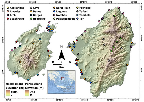
Figure 1.
Naxos and Paros islands. The selected geomorphosites have been classified and are shown in the map.
In the present work, a total of 75 geomorphosites on the islands of Naxos and Paros were selected and assessed according to the methodology proposed by Reynard et al. [1]. In particular, their scientific value was initially graded, referring to integrity, rarity, representativity and palaeogeographical value. Additional assessed values include ecology, economy, culture and aesthetics [1]. All values were synthesized, and thus the final assessment of the geomorphosites was conducted.
2. Study Area
The study area is located in the central Aegean Sea and includes Naxos and Paros islands, both of which belong to the Cyclades complex, Aegean Sea, Greece. The Cyclades consist of about 33 main Islands, the largest being Naxos, while Paros is the third largest. Naxos covers an area of 430 Km2, while its coastal zone extends for 148 Km. The island is mountainous, with a central mountain range trending N-S. The maximum altitude is 1001 m, the top of Zeus. Paros is located to the west of Naxos. It has an elliptical shape with a total area of 196 Km2. The territory of the island is mountainous in the center and flat on the coast. The altitude increases toward the interior of the island and specifically, increases in the central and southern part. The highest point of the island is the peak of Aghios Ilias with an altitude of 771 m [33].
Lithologically, Naxos consists of migmatized gneissic rocks containing marbles, metapelites and amphibolites, while a sequence of schists, gneisses, marbles and metavolcanics surround the migmatite dome [34]. Above the metamorphic series, Miocene–Pliocene sediments are found [35,36], mainly deposited in a fluvial, partly marine environment. The lithology of Paros is dominated by marbles, gneiss and schists, above which Neogene and Quaternary deposits are found [33].
Geomorphological Regime
The islands of the Cyclades form the so-called Cycladic plateau, whose altitudes generally increase eastward (the eastern Cycladic islands are larger in area and higher in altitudes than the western ones). The largest part of the Cycladic plateau is currently located beneath sea level and at an average depth of 100 m. A deep N-S tectonic graben segregates the westernmost islands (e.g., Kea and Kythnos) from the rest of the Cyclades. The marginal slopes of the plateau are located at a depth of approximately 200 m and generally coincide with the continental slope (Figure 2).
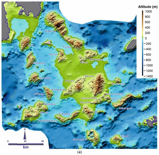
Figure 2.
Representation of the Cyclades region as it was 18,000 years ago and how the individual islands were gradually separated, as the region reached its present form. (a) Palaeogeography 18,000 years ago; (b) 12,500 years ago; (c) today.
The Aegean Sea is located in the convergence zone of the African and Eurasian plates [37]. Naxos and Paros islands are located in the center of the Aegean microplate (which is part of the Eurasian plate) and are relatively seismically inactive, although the regions surrounding the Cyclades are seismically active [37]. During the Eocene, tectonic compression took place, which was succeeded by an extensional regime during Oligocene or Miocene [38,39,40]. The Cycladic region is characterized by a relatively thin continental crust of about 25–26 Km, which is owed to two processes during the Cenozoic and Neogene. During the Cenozoic gravitational collapse of the Aegean crust took place due to the southward retreat of a subduction front, while during the Neogene, the extrusion of the Anatolian block westward took place. These procedures were due to the extensional tectonic regime at the center of the Aegean plate, as the area is behind the modern volcanic arc of Aegean (e.g., [41,42].
During the Quaternary, active tectonics played a significant role in the geomorphology of the Cyclades, but during Late Quaternary, eustasy also played a determining role. During the Last Glacial Maximum (18 Ka BP), most of the Cyclades were part of one single island and were gradually segregated when the sea-level rose. Paros and Naxos were the last islands that were separated, 8 Ka BP (Figure 2).
The current geomorphological landscape of both islands is mainly owed to their lithology, tectonics, drainage system and climate. Most of their landscape is a result of the combination of differential erosion due to frequent lithological alterations and exogenic processes. When it comes to tectonics, in certain areas, planation surfaces can be observed, indicating periods of tectonic stability and uplift. Additionally, downward erosion is notable in both islands, indicating an intense tectonic uplift status and wetter climate periods in the past.
As far as lithology is concerned, differential erosion has played a crucial role to the present-day geomorphology. Typical examples of landforms controlled by differential erosion are hogbacks, which dominate in the mainland, due to the frequent alterations, especially in the center of the islands, of marble, schists and gneisses. Gneisses are more vulnerable to erosion than marbles, thus, upon their erosion, the marbles protrude, revealing the previous relief of the area.
The existence of granodiorite has led to the creation of a unique relief form, due to its weathering. Tafoni are typical landforms owed to the weathering of granodiorites and other crystalline rocks. They consist of cavernous holes resembling honeycombs and are created due to both aeolian erosion processes and chemical weathering [43]. Smaller tafone-type cavities are usually referred to as alveoles [44]. Tafone-type landforms can be found in the western part of Naxos on granodiorite and the north part of Paros on granite. Erosion of the granodiorite produces sediments that end up in the coastal zone, hence the long and wide beaches of western Naxos, which are characterized by a sand composition that is similar to that of the granodiorite. Depositional processes have also born an impact on the landscape of Paros and Naxos. There are several plains, most of which are yet small in area. The plain of Naxos is the largest one in the Cyclades and covers a significant area compared to other plains of the Cyclades.
The western part of Naxos and the eastern part of Paros are characterized by long, sandy beaches, which is quite rare for the Cycladic landscape. In Naxos and Paros, this regime is owed to the lithological structure of the islands and the dominant weathering and erosional processes. The coasts of the islands are mainly steep and rocky, and to a lesser extent sandy, their morphology having mainly been shaped during Late Holocene [33]. They are characterized by a manifold morphology, i.e., bays, capes and several landform types. For instance, erosional landforms such as coastal caves can be found. Coastal cliffs are among the most dominant in both islands and in many cases, they have led to the formation of pocket beaches at their base. Yet, depositional processes also play an important role in shaping the coasts of the islands. Besides pocket beaches, for instance, sandy beaches are also common, in some of which dunes and/or coastal lagoons can be found [36,45,46]. Some rare depositional landforms include tombolos. The submarine landforms of Naxos and Paros, such as notches [47] and beachrocks [48,49], are quite common and generally reveal tectonic subsidence events and the consequent relative sea-level rise, as well as the evolution of the coastal zone [50,51,52] (see Supplementary Material). Beachrocks also act in a protective way for the coasts, as part of the wave energy is consumed on them.
3. Materials and Methods
The data used in the present study have derived from several field trips in the two islands during the last decades. They concern information about geomorphosites of the study area and they were used for their inventory, classification, and evaluation. The inventory of geomorphosites was developed in three stages. Initially, the geomorphological characteristics of the study area were identified and mapped. Consequently, the geomorphosites representing the geomorphology of the area were recorded, and finally, the ones that had scientific value were selected.
The assessment of geomorphosites follows the method proposed by Reynard et al. 2007 [1], which concerns the evaluation of geomorphosites at regional level and provides criteria for their evaluation [1,15]. These criteria are divided into five main categories, which are further divided into subcategories. The basic categories mentioned in the method are general data, descriptive data, scientific value, additional values and synthesis and were used to classify and evaluate the selected geomorphosites.
More specifically, the studied sites were named and categorized according to the method proposed by Reynard et al. [1] and examined regarding two values: scientific and additional values (ecological, cultural, economic and aesthetic value). Each geomorphosite is named with an identification code, which derives from: (a) the abbreviation of its location with capital letters, (b) the main process of its formation and (c) its number. The main processes of our study area and their codes represent the following: WEA = weathering, KAR = karstic, LIT = littoral, FLU = fluvial, EOL = aeolian, DIFR = differential erosion.
The scientific value is divided into four categories, namely: integrity, representativeness, rareness, and palaeogeographical interest [1]. Integrity is related to the state of each geomorphosite conservation. Representativeness is related to geomorphosite exemplarity. Rareness is related to the rarity of the geomorphosite depending on the reference area. Finally, palaeogeographical value is related to the importance of geomorphosite’s location as a component of Earth’s evolution. Each geomorphosite was graded for each of the aforementioned values, with a grade ranging from 0 to 1 [1]. Table S1 presents the assessment criteria and scoring for the scientific value, based on Reynard et al. [1] and Bouzekraoui et al. [53]. The final scientific value derives from the average of integrity, representativeness, rareness, and palaeogeographical interest.
Regarding the additional values, they are composed of the ecological, cultural, economic, and aesthetic value [1]. The ecological value corresponds to the arithmetic mean of two elements: (i) ecological impact, which accounts for the significance of a geomorphosite for the development of a particular ecosystem, and (ii) the protection status of the geomorphosite. The aesthetic values correspond to the arithmetic mean of two elements: (i) the viewpoints of a particular geomorphosite, that is its visibility, and (ii) structure that considers the contrasts and vertical development of a landform, therefore those with color contrasts or high vertical development obtain a higher value. The cultural value is composed of four elements, religious importance, historical importance, artistic or literary importance and geohistorical importance; for this value, the element having the highest value is considered. Lastly, the economic value takes into consideration the qualitative and/or quantitative assessment of the products generated by a particular geomorphosite. Table S2 presents the assessment criteria and scoring for the additional values, based on Reynard et al. [1] and Bouzekraoui et al. [53].
The results from the geomorphological synthesis were presented on GIS. Geomorphosites, the categories of criteria and their evaluations were recorded in a database, which were subsequently incorporated into GIS. After analyzing and processing the data, several maps were created with the use of ArcGIS Pro v.2.8.3 and its modules, which depict the selected geomorphosites categorized.
4. Results and Discussion
4.1. Description of the Geomorphosites
The sites of geomorphological interest that were selected through this research are described in this section. In this research, a total of 75 geomorphosites were selected. Sites referred below may be found in the two interactive maps developed for the purposes of this paper. Specifically, the interactive map of Naxos can be found at https://arcg.is/0LzWrv1 (accessed on 13 December 2021) and for Paros at https://arcg.is/01f09a (accessed on 13 December 2021). The maps in Figure 3 and Figure 4 depict the studied geomorphosites, as well as spider diagrams regarding their scientific and additional values. In these spider diagrams, one can observe the distribution of the individual values (scientific, aesthetic, ecological, economic and cultural) for each geomorphosite. The following link provides this information in a dashboard https://www.arcgis.com/apps/dashboards/a3cf026ba865488eb966407991b2e5b8 (accessed on 13 December 2021). For practical reasons, the selected sites were categorized according to the geomorphological environment/processes that led to their formation. Therefore, the main categories include coastal, karstic, aeolian and erosional landforms (the latter excluding landforms that belong to the previous categories).
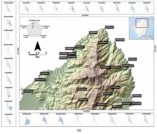
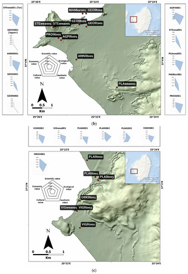
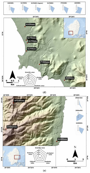
Figure 3.
Terrain map of Naxos Island split into five parts (a–e), where the selected geomorphosites, as well as spider diagrams regarding their values are depicted. Each spider diagram consists of a sequence of equi-angular spokes, with each spoke representing one of the following variables: scientific value, economic value, ecological value, cultural value, and aesthetic value.
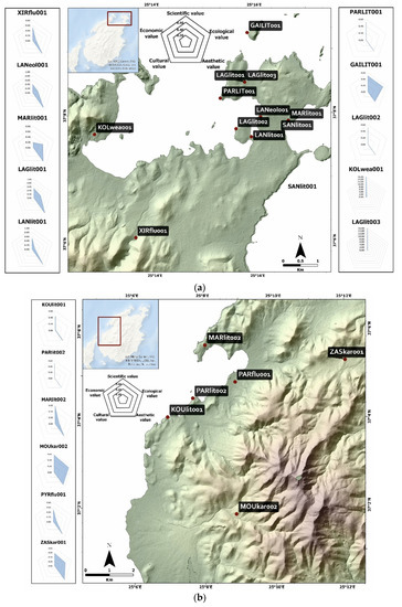
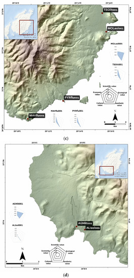
Figure 4.
Terrain map of Paros Island split into four parts (a–d), where the selected geomorphosites, as well as spider diagrams regarding their values are depicted. Each spider diagram consists of a sequence of equi-angular spokes, with each spoke representing one of the following variables: scientific value, economic value, ecological value, cultural value, and aesthetic value.
The Supplementary Table S3 includes the detailed geomorphosites assessment, including the name of each site, location, the landform(s) that can be observed, as well as its grading regarding the individual values discussed above (integrity, representativeness, rareness, palaeogeographical interest, ecological, cultural, economic and aesthetic value) and its final grading. The coastal landforms of Naxos and Paros islands include beachrocks, coastal lagoons, tidal notches, coastal dunes, tombolos and palaeotombolos. Beachrocks are mainly found in the areas of Aghios Georgios, Plaka, Orkos, Mikri Vigla, Glyfada, Ramnos, Martselo and Tsoukalia. Tidal notches can be found in the areas of Galini, Kampos, Northern Paros, Gaidouronisi, Lageri, Koukoumvales, Parasporos, as well as in four different sited near Hilia Vrysi. Tombolos are found in Aghios Georgios and Lageri, whereas a palaeotombolo can be observed in Plaka, Naxos. Coastal lagoons can be found in Mikri Vigla, Glyfada, Aghios Prokopios, Aghios Georgios, Agiasso and Lageri.
Aeolian landforms include one aeolianite site in Manto island, Naxos, as well as coastal dunes found in the areas of Aghios Georgios, Aghia Anna, Plaka, Kastraki, Glyfada, Pyrgaki, Kanaki, Azala, Lageri, Alyki, Molos and Santa Maria. Karstic landforms in Paros and Naxos islands include one cave, two potholes and two karst plains. The former refers to the Cave of Zas mountain near Filoti, Naxos, whereas the two karst plains are located in Korakas Hill, Marathi and Moutsi. The two potholes are located in Koronos-Koronida and Moutsouna, Naxos.
Erosional landforms include gorges, hogbacks, tafonis, tors and alveoles. Four gorges were considered worthy of assessing, namely in Mavros Kavos, Pyrgos Cape, Xiropotamos River and Paroikia. Characteristic hogbacks are found in northern Naxos, whereas the most important tafoni formations are in Stelida, Moni Chrysostomou, Plaka and Kinidaros. Tor sites include the areas of Stelida and Mikri Vigla, Naxos island, whereas a characteristic alveolus site is Kolymbithres in Paros island.
4.2. Quantitative Assessment of the Geomorphosites
The quantitative assessment of the geomorphosites can be seen in the Supplementary Table S3. Overall, the scientific value ranges between 0.38 and 0.81. 47 out of the 75 geomorphosites are graded with at least 0.5. Integrity is high (0.75 or 1) for 61% of them and 0.5 for 30% of them. As far as representativeness is concerned, 42% of the 75 geomorphosites are rated with 0.75 or 1 and 13% with 0.5. When it comes to rareness, 36% of the geomorphosites are rare (0.75 or 1-graded) and another 36% of them medium (0.5). The palaeogeographical value is the lowest ranking among the four aspects of the scientific value, as the highest rate is 0.5 and only refers to a 12% of the total number of the geomorphosites (Figure 5 for Naxos; Figure 6 for Paros). Overall, regarding the scientific value of the studied geomorphosites, the criteria of integrity received the highest values, while the criteria of palaeogeographic value received the lowest ranking. Geomorphosites, such as hogbacks, dunes and beachrocks were among the ones receiving the highest ranking in terms of scientific value overall, while features such as tors or potholes received lower ratings (Table 1).
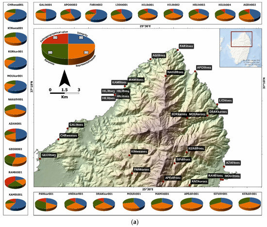
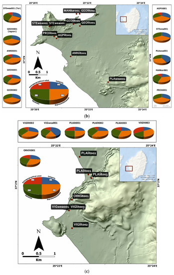
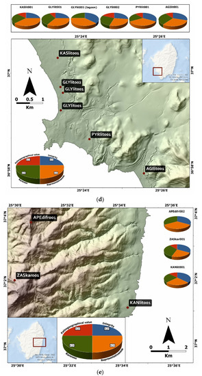
Figure 5.
Map of Naxos split into five parts (a–e) showing the geomorphosites and their scientific value. The diagrams framing the map show the contribution of each parameter (integrity, representativeness, rareness, and palaeogeographical value) to the final calculation of the scientific value for each geomorphosite. The blue section of the pie chart represents the integrity, the green section represents the rareness, the orange section defines the representativeness, and the red section represents the palaeogeographical value.
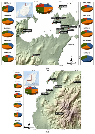
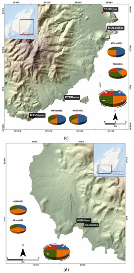
Figure 6.
Map of Paros split into four parts (a–d), showing the geomorphosites and their scientific value. The blue section of the pie chart represents the integrity, the green section represents the rareness, the orange section defines the representativeness, and the red section represents the palaeogeographical value.

Table 1.
Average values of the ratings for the assessed geomorphosites.
As far as the additional values are concerned, 55% of the 75 geomorphosites are highly rated (more than 0.5), whereas 19% of them are rated with 0.5. Regarding ecology, 29% of the selected geomorphosites are graded with more than 0.5 and 7% with 0.5. The other two aspects (economy and culture) do not seem to play an important role in the geomorphological heritage of the two islands, as there is only one geomorphosite whose economical value is 0.5 (the rest being 0-graded), two geomorphosites whose cultural value is 0.75 and another two whose cultural value is 0.5 (the rest being 0-graded) (Figure 7 for Naxos; Figure 8 for Paros). It should however be noted that no quantitative data were available for a direct estimation of the economic value of the studied geomorphosites.
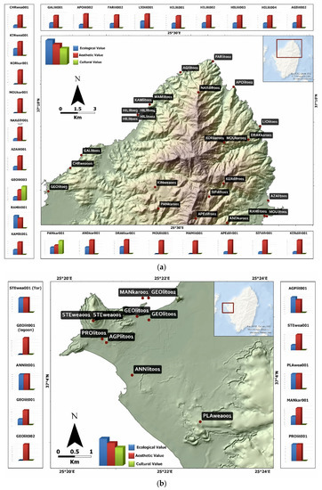
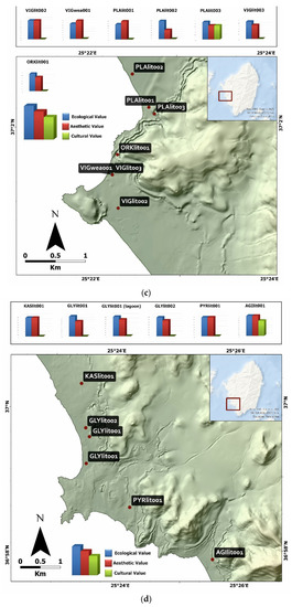
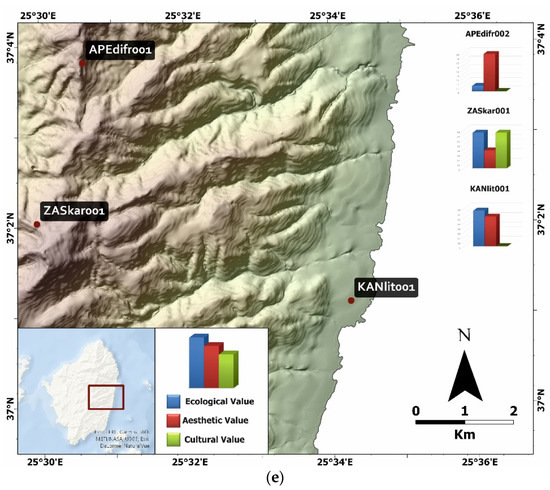
Figure 7.
Map of Naxos split into five parts (a–e), showing the geomorphosites and their additional values. The diagrams framing the map show the relationship between ecological, aesthetic, and cultural value for each geomorphosite. The blue columns represent the ecological value, the red columns represent the aesthetic value, and the green columns represent the cultural value.
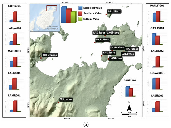
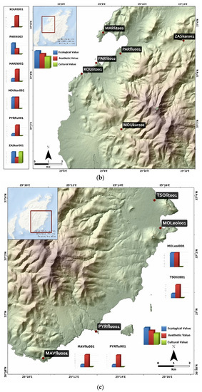
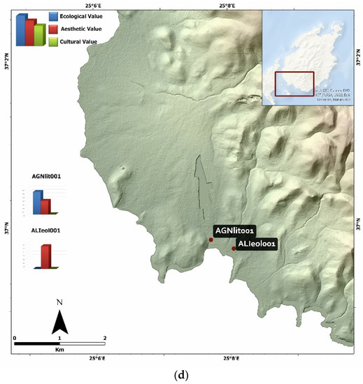
Figure 8.
Map of Paros split into four parts (a–d), showing the geomorphosites and their additional values. The diagrams framing the map show the relationship between ecological, aesthetic, and cultural value for each geomorphosite. The blue columns represent the ecological value, the red columns represent the aesthetic value, and the green columns represent the cultural value.
The aesthetic and the ecological value vary depending on the type of geomorphosite. The aesthetic value maintains high values in the majority of geomorphosites, compared to the ecological value which fluctuates from 0 to 0.875. Unlike the aesthetic value and the ecological value, the cultural value appears only in lagoon (e.g., AGIlit001), beachrock (e.g., GEOlit003, PLAlit003) and cave (e.g., ZASkar001, PANkar001) geomorphosites.
The highest-ranking geomorphosites include the beachrocks in Aghios Georgios, Naxos and the tidal notches NW of Koukoumavles, Paros, the scientific value reaching 0.81. The additional values in these cases are relatively low (generally between 0.1 and 0.6). Besides them, there exist another 11 geomorphosites (18% in total) whose scientific value exceeds 0.6. Regarding their additional values, they are characterized by a high ecological and aesthetic value. A total of 39 geomorphosites (65%) are characterized by medium value, between 0.4 and 0.6. These geomorphosites are generally characterized by a high aesthetic value (more than 0.5), whereas 14 of them are also of high ecological value. A total of 11 geomorphosites (16%) are of low scientific value (less than 0.4), most of which are of high aesthetic value and only three of high ecological value.
4.3. The Geotouristic Potential of Paros and Naxos Islands
Both islands are characterized by special geomorphological and environmental features. Presently, both islands receive most tourists during the summer period and while certain geomorphosites are known and visited, such as the cave of Zas (ZASkar001) or Cave of Panagia (PANkar001), other landforms are either visited, but their particular value is not acknowledged due to lack of information, or they remain completely unknown. Overall, the geotouristic potential of both islands is poorly exploited at present. For the case of Paros, recent efforts include the development of an environmental-cultural park on the north part of the island. However, its most prominent actions are related to cultural activities primarily during the high summer season. In the case of Naxos, the island is visited by many international tourists wishing to experience quitter vacations and more natural landscapes. While both islands have all those elements that can attract the interest of geotourists, they have not exploited this possibility yet, possibly because they accept a lot of tourism in the summer months anyway and feel that they are covered or possibly because they put all their efforts in the summer tourism and lack the energy to expand the touristic season. The effort to develop geotourism needs organization and the right decisions from decision makers and the local society in order to open the tourist product and attract visitors at different times and not only during the summer, hence reducing the intensification of tourism in the summer months, which has reached its limits and often leads to negative comments. Both islands still lack a clear plan for the development of geotourism and the promotion of geotouristic features and activities.
The above call for better promotion and information to the public and perspective tourists on the geomorphological heritage of both islands; such actions could include the inclusion of geomorphosites to tourist guides, the design of geo-routes, the development of StoryMaps, etc. The promotion of geomorphological heritage in the area will clearly contribute to the enhancement of tourism, supporting the environmental and geomorphological beauties of the island and enhancing geotourism and eco-tourism. It is important to emphasize the difference in quality and time of arrival for this category of tourists, which will extend the touristic season, but at the same time will respect the heritage of the islands. The promotion of geomorphological heritage will provide the appropriate tools for informing the public about environmental pressures, their effects, and the need for protection. It will also provide reliable proposals and solutions for geoenvironmental problems and, on the other hand, will promote and promote the concept of geo-conservation.
New generations of tourists are composed of travelers who need nature, they are more educated and looking for alternative tourist destinations. In the list of the most frequent touristic destinations, geological and geomorphological landscapes often stand out, replacing other classic tourist destinations of the past. Among the most famous geotouristic destinations are Yellowstone, the Grand Canyon, Yosemite Valley Park and the Great Barrier Reef [54].
Such destinations, with proper management, contribute to the sustainable development of the areas, i.e., a development that meets the needs of current generations, without compromising the rights and needs of future generations. It is worth mentioning that tourism, due to the intensifying competition, is being modernized and enriched by developing new products. In the global tourism market and especially in the European, in recent years, alternative forms of tourism development are being promoted, especially those that are compatible with the directions of protection of the natural and cultural environment.
5. Conclusions
A total of 75 geomorphosites were selected, mapped and assessed in this research, namely 22 in Paros and 53 in Naxos island, Cyclades, Greece. They were assessed such that their promotion, as well as their geoconservation, can be rendered possible. The assessment of the geomorphosites followed the assessment method proposed by Reynard et al. [1]. Based on field work and the consequent assessment of the visited areas as potential geomorphosites, we have concluded that the islands of Naxos and Paros are of vast geomorphological heritage that is worth conserving and promoting and can lead to the further economic development of the two regions. Both islands are abundant in unique coastal landforms great sea-level and palaeogeography indicators, as well as landforms created in other environments. Besides the high scientific interest of the 63 geomorphosites, most of them are also characterized by a high ecological value and can potentially lead to a significant increase in the islands’ tourism, not in the sense of massive tourism, which usually leads to degradation, but qualitive tourism, for instance geotourism and ecotourism. The promotion and management of these geomorphosites can contribute to the development of the local economy, given that both islands are highly popular and therefore do not lack the corresponding facilities for hosting geotourism.
Supplementary Materials
The following are available online, Table S1: Geomorphosites database. Geomorphological data for Naxos island are available at https://arcg.is/0LzWrv1 (accessed on 13 December 2021) and for Paros at https://arcg.is/01f09a (accessed on 13 December 2021).
Author Contributions
Conceptualization, N.E. and A.K.; methodology, N.E., A.K., M.T. and E.S.; investigation, N.E., A.K., M.T., E.S., A.P. and L.L.; writing—original draft preparation, N.E., A.K., E.S. and A.P.; writing—review and editing, N.E., A.K., M.T., E.S. and A.P.; visualization, M.T.; supervision, N.E. All authors have read and agreed to the published version of the manuscript.
Funding
This research received no external funding.
Data Availability Statement
The data used for this work can be found at the Supplementary Material.
Conflicts of Interest
The authors declare no conflict of interest.
References
- Reynard, E.; Fontana, G.; Kozlik, L.; Scapozza, C. A method for assessing “scientific” and “additional values” of geomorphosites. Geogr. Helv. 2007, 62, 148–158. [Google Scholar] [CrossRef]
- Brilha, J.B. Património Geológico e Geoconservação: A Conservação da Natureza na sua Vertente Geológica; Palimage: Coimbra, Portugal, 2005. [Google Scholar]
- Gray, M. Geodiversity: Valuing and Conserving Abiotic Nature; Wiley: Oxford, UK, 2004. [Google Scholar]
- Martini, G. (Ed.) Actes du Premier Symposium International sur la Protection du Patrimoine Géologique, Digne-les-Bains, 11–16 June 1991; Société Géologique de France: Paris, France, 1994. [Google Scholar]
- Panizza, M. Geomorphosites: Concepts, methods and example of geomorphological survey. Chin. Sci. Bull. 2001, 46, 4–5. [Google Scholar] [CrossRef]
- Panizza, M.; Piacente, S. Geomorphological assets evaluation. Z. Geomorphol. 1993, 87, 13–18. [Google Scholar]
- Grandgirard, V. Géomorphologie, Protection de la Nature et Gestion du Paysage. Ph.D. Thesis, Faculté des Sciences, Université de Fribourg, Fribourg, Switzerland, 1997. (In French). [Google Scholar]
- Reynard, E.; Panizza, M. Geomorphosites: Definition, assessment and mapping. Géomorphologie Relief Process. Environ. 2005, 11, 177–180. [Google Scholar] [CrossRef]
- Panizza, M.; Piacente, S. Geomorfologia Culturale; Pitagora: Bologna, Italy, 2003. [Google Scholar]
- Fassoulas, C.; Zouros, N. Evaluating the influence of Greek geoparks to the local communities. Bull. Geol. Soc. Greece 2017, 43, 896. [Google Scholar] [CrossRef]
- Rivas, V.; Rix, K.; Francés, E.; Cendrero, A.; Brunsden, D. Geomorphological indicators for environmental impact assessment: Consumable and non-consumable geomorphological resources. Geomorphology 1997, 18, 169–182. [Google Scholar] [CrossRef]
- Cendrero, A.; Panizza, M. Geomorphology and environmental impact assessment: An introduction. Suppl. Geogr. Fis. Din. Quat. 1999, 3, 167–172. [Google Scholar]
- Bruschi, V.M.; Cendrero, A. Geosite evaluation: Can we measure intangible values? Il Quat. 2005, 18, 293–306. [Google Scholar]
- Bruschi, V.M.; Cendrero, A. Direct and parametric methods for the assessment of geosites and geomorphosites. In Geomorphosites; Reynard, E., Coratza, P., Regolini-Bissig, G., Eds.; Pfeil: München, Germany, 2009; pp. 73–88. [Google Scholar]
- Reynard, E.; Perret, A.; Bussard, J.; Grangier, L.; Martin, S. Integrated approach for the inventory and management of geomorphological heritage at the regional scale. Geoheritage 2016, 8, 43–60. [Google Scholar] [CrossRef]
- Pralong, J.-P. Géotourisme et Utilisation de Sites Naturels D’intérêt Pour les Sciences de la Terre. Les Régions de Crans-Montana Sierre (Valais, Alpes Suisses) et Chamonix-Mont-Blanc (Haute-Savoie, Alpes françaises); Travaux et Recherches; Institut de Géographie: Lausanne, Switzerland, 2006; Volume 32, 224p. [Google Scholar]
- Reynard, E.; Holzmann, C.; Guex, D. Géomorphologie et tourisme: Quelles relations? In Géomorphologie et Tourisme; Travaux et Recherches; Reynard, E., Holzmann, C., Guex, D., Summermatter, N., Eds.; Institut de Géographie: Lausanne, Switzerland, 2003; Volume 24, pp. 1–10. [Google Scholar]
- Grandgirard, V. L’évaluation des géotopes. Geol. Insubrica 1999, 4, 59–66. [Google Scholar]
- Brilha, J. Inventory and quantitative assessment of geosites and geodiversity sites: A review. Geoheritage 2016, 8, 119–134. [Google Scholar] [CrossRef]
- Giusti, C.; Calvet, M. The inventory of French geomorphosites and the problem of nested scales and landscape complexity. Geomorphol. Relief Process. Environ. 2010, 2, 223–244. [Google Scholar] [CrossRef]
- de Lima, F.F.; Brilha, J.B.; Salamuni, E. Inventorying geological heritage in large territories: A methodological proposal applied to Brazil. Geoheritage 2010, 2, 91–99. [Google Scholar] [CrossRef]
- Mucivuna, V.C.; Reynard, E.; da Glória Motta Garcia , M. Geomorphosites assessment methods: Comparative analysis and typology. Geoheritage 2019, 111, 1799–1815. [Google Scholar] [CrossRef]
- Reynard, E.; Coratza, P.; Hobléa, F. Current Research on Geomorphosites. Geoheritage 2016, 8, 1–3. [Google Scholar] [CrossRef]
- Reynard, E. Scientific research and tourist promotion of geomorphological heritage. Geogr. Fis. Din. Quat. 2008, 31, 225–230. [Google Scholar]
- Bissig, G. Mapping geomorphosites: An analysis of geotourist maps. Geotourism/Geoturystyka 2008, 14, 3. [Google Scholar] [CrossRef][Green Version]
- Carton, A.; Coratza, P.; Marchetti, M. Guidelines for geomorphological sites mapping: Examples from Italy. Géomorphologie 2005, 3, 209–218. [Google Scholar] [CrossRef]
- Carton, A.; Coratza, P.; Marchetti, M. Nota preliminare sulla cartografia dei geomorfositi. In La Memoria della Terra, la Terra della Memoria; Piacente, S., Poli, G., Eds.; L’Inchiostroblu: Bologna, Italy, 2003; pp. 114–120. [Google Scholar]
- Papanikolaou, D.I. Geology of Greece; Patakis: Athens, Greece, 2015. [Google Scholar]
- Goldsworthy, M.; Jackson, J. Active normal fault evolution in Greece revealed by geomorphology and drainage patterns. J. Geol. Soc. 2020, 157, 967–981. [Google Scholar] [CrossRef]
- Zouros, N.C. Geomorphosite assessment and management in protected areas of Greece. Geogr. Helv. 2007, 62, 169–180. [Google Scholar] [CrossRef]
- Hellenic Geoparks Forum. Available online: http://www.hellenicgeoparks.gr/?page_id=46 (accessed on 20 September 2021).
- Gaki-Papanastassiou, K.; Evelpidou, N.; Maroukian, H.; Vassilopoulos, A. Palaeogeographic Evolution of the Cyclades Islands (Greece) during the Holocene; Springer: Dordrecht, The Netherlands, 2009; pp. 297–304. [Google Scholar]
- Evelpidou, N. Geological and Geomorphological Observations in Paros Island (Cyclades) Using Photo Interpretation and GIS Methods. Master’s Thesis, Faculty of Geology and Geoenvironment, National and Kapodistrian University of Athens, Athens, Greece, 1997. [Google Scholar]
- Pe-Piper, G.; Kotopouli, C.N.; Piper, D.J. Granitoid rocks of Naxos, Greece: Regional geology and petrology. Geol. J. 1997, 32, 153–171. [Google Scholar] [CrossRef]
- Angelier, J.; Lyberis, N.; Le Pichon, X.; Barrier, E.; Huchon, P. The tectonic development of the Hellenic arc and the Sea of the Crete: A synthesis (Mediterranean). Tectonophysics 1982, 86, 159–196. [Google Scholar] [CrossRef]
- Jansen, J.B.H. Geological Map of Greece, Island of Naxos (1:50,000); Institute for Geology and Mineral Resources: Athens, Greece, 1973. [Google Scholar]
- Bargnesi, E.A.; Stockli, D.F.; Mancktelow, N.; Soukis, K. Miocene core complex development and coeval supradetachment basin evolution of Paros, Greece, insights from (U–Th)/He thermochronometry. Tectonophysics 2013, 595, 165–182. [Google Scholar] [CrossRef]
- Gautier, P.; Brun, J.P.; Moriceau, R.; Sokoutis, D.; Martinod, J.; Jolivet, L. Timing, kinematics and cause of Aegean extension: A scenario based on a comparison with simple analogue experiments. Tectonophysics 1999, 315, 31–72. [Google Scholar] [CrossRef]
- Gautier, P.; Brun, J.P. Crustal-scale geometry and kinematics of late-orogenic extension in the central Aegean (Cyclades and Ewia Island). Tectonophysics 1994, 238, 399–424. [Google Scholar] [CrossRef]
- Jolivet, L. A comparison of geodetic and finite strain pattern in the Aegean, geodynamic implications. Earth Planet. Sci. Lett. 2001, 187, 95–104. [Google Scholar] [CrossRef]
- Tirel, C.; Gueydan, F.; Tiberi, C.; Brun, J.P. Aegean crustal thickness inferred from gravity inversion. Geodynamical implications. Earth Planet. Sci. Lett. 2004, 228, 267–280. [Google Scholar] [CrossRef]
- Zhu, L.; Mitchell, B.J.; Akyol, N.; Cemen, I.; Kekovali, K. Crustal thickness variations in the Aegean region and implications for the extension of continental crust. J. Geophys. Res. 2006, 111. [Google Scholar] [CrossRef]
- Soukis, K.; Koufosotiri, E.; Stournaras, G. Special Landforms on Tinos Island: Spheroidal Weathering “TAFONI” Forms, 3rd ed.; International Scientific Symposium of Protected Areas and Natural Monuments: Mytilini, Greece, 1998. (In Greek) [Google Scholar]
- Theodoropoulos, D. Honeycomb weathering phenomena (TAFONI) on Tinos Island. Ann. Géologiques Pays Helléniques 1975, 26, 149–158. (In Greek) [Google Scholar]
- Cordier, S.; Schlüchter, M.-L.; Evelpidou, N.; Pavlopoulos, K.; Bouchet, M.; Frechen, M. Morphology and OSL-420 based geochronology of the Holocene coastal dunes fields of Naxos Island (Cyclades, Greece): Preliminary 421 results. In Proceedings of the XVIII INQUA Congress, Bern, Switzerland, 21–27 July 2011. [Google Scholar]
- Evelpidou, N.; Melini, D.; Pirazzoli, P.; Vassilopoulos, A. Evidence of a recent rapid subsidence in the S–E 417 Cyclades (Greece): An effect of the 1956 Amorgos earthquake? Cont. Shelf Res. 2012, 39–40, 27–40. [Google Scholar] [CrossRef]
- Evelpidou, N.; Melini, D.; Pirazzoli, P.A.; Vassilopoulos, A. Evidence of repeated late Holocene rapid subsidence 439 in the SE Cyclades (Greece) deduced from submerged notches. Int. J. Earth Sci. 2013, 103, 381–395. [Google Scholar] [CrossRef]
- Karkani, A.; Evelpidou, N.; Vacchi, M.; Morhange, C.; Tsukamoto, S.; Frechen, M.; Maroukian, H. Tracking 427 shoreline evolution in central Cyclades (Greece) using beachrocks. Mar. Geol. 2017, 388, 25–37. [Google Scholar] [CrossRef]
- Saitis, G.; Koutsopoulou, E.; Karkani, A.; Anastasatou, M.; Stamatakis, M.; Gatou, M.-A.; Evelpidou, N. A multi- analytical study of beachrock formation in Naxos and Paros Islands, Aegean Sea, Greece and their palaeoenvironmental significance. Z. Geomorphol. 2021, 63, 19–32. [Google Scholar] [CrossRef]
- Karkani, A. Study of the geomorphological and environmental evolution of the coastal zone of Central Cyclades. Ph.D. Thesis, National and Kapodistrian University of Athens, Athens, Greece, 2017. [Google Scholar]
- Sakellariou, D.; Galanidou, N. Pleistocene submerged landscapes and Palaeolithic archaeology in the tectonically 451 active Aegean region. Geol. Soc. Lond. Spec. Publ. 2016, 411, 145–178. [Google Scholar] [CrossRef]
- Desruelles, S.; Fouache, É.; Ciner, A.; Dalongeville, R.; Pavlopoulos, K.; Kosun, E.; Coquinot, Y.; Potdevin, J.-L. 447 Beachrocks and sea level changes since Middle Holocene: Comparison between the insular group of Mykonos– 448 Delos–Rhenia (Cyclades, Greece) and the southern coast of Turkey. Glob. Planet. Chang. 2009, 66, 19–33. [Google Scholar] [CrossRef]
- Bouzekraoui, H.; Barakat, A.; Touhami, F.; Mouaddine, A.; El Youssi, M. Inventory and assessment of geomorphosites for geotourism development: A case study of Aït Bou Oulli valley (Central High-Atlas, Morocco). Area 2018, 50, 331–343. [Google Scholar] [CrossRef]
- Gray, M. “Simply the best”: The search for the world’s top geotourism destinations. In The Geotourism Industry in the 21st Century; Sadry, B.N., Ed.; Apple Academic Press: Boca Raton, FL, USA, 2020; pp. 207–226. ISBN 9780429292798. [Google Scholar]
Publisher’s Note: MDPI stays neutral with regard to jurisdictional claims in published maps and institutional affiliations. |
© 2021 by the authors. Licensee MDPI, Basel, Switzerland. This article is an open access article distributed under the terms and conditions of the Creative Commons Attribution (CC BY) license (https://creativecommons.org/licenses/by/4.0/).