Abstract
The increasing availability and sinking costs of unmanned aerial vehicles (UAVs), commonly known as drones, has resulted in these devices becoming relatively commonplace on archaeological sites. The advantages of being able to rapidly obtain bespoke high-resolution images from the air are conspicuous to anyone familiar with archaeological fieldwork; meanwhile the possibilities of subsequently processing such images together with their metadata to obtain digital elevation models (DEMs) and three-dimensional (3-D) models provide additional bonuses to analysis and interpretation. The recent use of a rotary-wing drone by the Western Harra Survey (WHS), an archaeological project co-directed by the author in the “Black Desert”, or Harra, of north-eastern Jordan, showcases these advantages in the context of a landscape that (a) is subject to negligible transformation processes and (b) is difficult to access, both by vehicle and on foot. By using processed drone imagery to record in detail prehistoric basalt structures visible on the surface and their surroundings, morphological site typologies hypothesised from satellite imagery were confirmed, relative dating within sites ascertained, structural features and damage documented, spatial relationships to natural resources established, offsite features traced, modern threats to heritage catalogued, and practically inaccessible sites investigated. Together, these results, most of which were only obtainable and all of which were obtained more rapidly by using a drone, represent significant insights into this underrepresented region, and provide a case-study for the benefits of these devices in other landscapes of a similar nature.
1. Introduction
Archaeology is a discipline that has embraced aerial documentation from its very outset, beginning with balloon and aircraft imagery from at least the early 20th century onwards [1]. Therefore, it is not surprising that the advantages of small-sized unmanned aerial vehicles (UAVs), known as drones, have been recognised and used by numerous projects across the globe since the commencement of their commercial availability and viability [2]. Already in the early 2000s, an unmanned remote helicopter, the forerunners of today’s rotary-wing drones, was being used by a team from the ETH Zürich at the pre-Incan settlement of Pinchago Alto, Peru, to aerially document and create computerised models of its stone walls [3]. Since the mid-2010s, they have become relatively commonplace on archaeological fieldwork sites, greatly facilitating the planning, data recording, and analysis of both surveyed and excavated remains. Broadly, these devices fall into two categories: Fixed-wing and rotary-wing craft. The former is best suited for large-scale landscape documentation, as they can attain a higher altitude and have a much longer range than the latter—however, they require space for take-off and landing and a significant amount of expertise to pilot. Rotary-wing craft, by contrast, are best suited to the documentation of smaller-scale areas (for example, individual archaeological features), take off and land vertically, are easily piloted, and can have their flight trajectories rapidly adjusted for ad hoc documentation of specific details [2,4] (p. 278). Together, drones have greatly increased the possibilities for archaeologists to not only easily record points of interest from the air in extreme detail, but also process their imagery to bring to light data otherwise hidden from view [5].
Aerial archaeology in the country of Jordan is no exception, and commenced at least as early as the 1920s, with the photographs of P. E. Maitland, L. W. B. Rees, and O. G. S. Crawford [6]. With the creation of the Aerial Photographic Archive for Archaeology (APAAME) [7] in 1978, and especially since its commencement of flights for explicit archaeological purposes in 1997 [8], systematic aerial photographs in specific locations and at high enough resolutions to be used for accurate interpretations of archaeological remains became widely available. However, widespread use of UAVs for archaeological work has in Jordan somewhat lagged behind their implementation in other countries for a number of reasons. As is the case in most nations, the laws surrounding the use of these devices has been changing rapidly in the last few years in Jordan, and while some projects had success legally importing and exporting drones in co-operation with its Department of Antiquities in the early 2010s, this became more difficult after a review of the regulations in 2016 [9]. Subsequent attempts were unable to obtain clearance for the import and export of such devices through the expected channels, and for several years no archaeological fieldwork teams made use of them. In 2018, the Western Harra Survey, a project co-directed by the author and located in the north-eastern deserts of the country, contacted the Royal Film Commission, a public organisation responsible, amongst other things, for facilitating and obtaining permits for commercial and private filming in Jordan, including the use of drones [10]. This has resulted in a fruitful collaboration that allowed this project to make use of such a device during its April and September 2019 fieldwork seasons.
The Western Harra Survey (WHS) is a multidisciplinary project co-directed by the author and Dr. Marie-Laure Chambrade, CNRS, Archéorient, in collaboration with the Institut Français du Proche-Orient (IFPO) and the Department of Antiquities of the Kingdom of Jordan. It is located in the so-called “Black Desert”, or Harra, an arid landscape that is part of the Harra’t al-Sham, a 50,000 km2 basaltic plateau stretching from southern Syria to north-western Saudi Arabia (Figure 1). The Jordanian Harra covers 11,400 km2 and consists primarily of lava flows dating from the Oligocene to the Quaternary (most recently ca. 400,000 BP), covered with a silty loess, above which basalt blocks almost completely pave the surface, largely protecting it from aeolian processes (Figure 2) [11]. This makes traversing this region extremely difficult to this day, except along seasonal rainfall valleys (called awdiya; singular: wadi) or mudflats (called qe’an; singular: qa’a). Countless structures built from this local basalt stone exist in the region, and although known to its Bedu nomads for centuries, they were not recorded in either text or image until the 1920s, while their academic study properly commenced in the 1970s with excavations and surveys at the site of Jawa, followed by the same at Dhuweila [12,13,14,15]. Since then, a handful of surveys and excavations have evidenced widespread prehistoric occupation of the area, and despite a lack of consensus on whether the majority of structures were permanent settlements or seasonal camps, both typological and scientific dating indicates a long, though not necessarily continuous, occupation chronology lasting from at least the Middle Palaeolithic (max. ca. 200,000 BP) [16] (p. 629) to the Roman period (3rd century AD) [17].
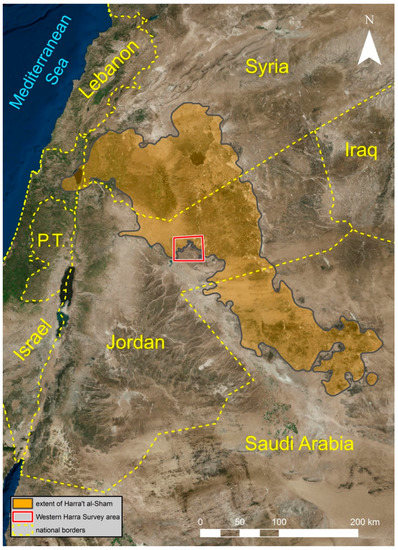
Figure 1.
Map of the location of the Western Harra Survey (WHS) and the extent of the Harra’t al-Sham (32°0′ N, 37°6′ E). Sources: Esri, DigitalGlobe, GeoEye, i-cubed, USDA FSA, USGS, AEX, Getmapping, Aerogrid, IGN, IGP, swisstopo and the GIS User Community. This figure has previously been published in [18].
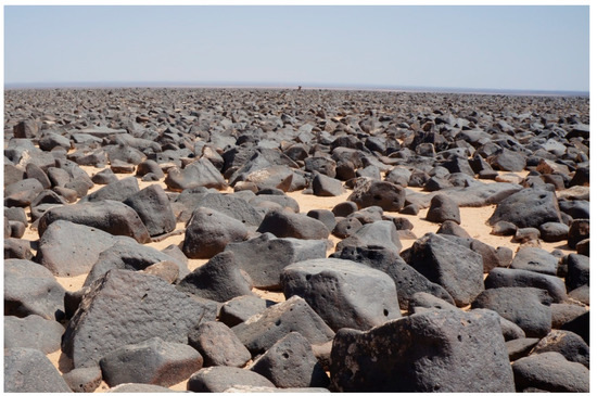
Figure 2.
A view of the typical landscape of dense basalt blocks atop silty loess that makes up the majority of the Harra. This figure has previously been published in [18].
The main goals of the WHS are to explore and study the interior of this landscape, with a focus on the geography, geology, and prehistoric human occupation (emphasising the seventh to early third millennium BC), using a 36 by 32 km survey area located in the western portion of the basalt region as a proxy (Figure 3) [18,19,20,21,22]. Following an intensive remote sensing survey using freely available very high-resolution satellite imagery from the GoogleEarth platform, which identified 2770 individual features in the study area, the first fieldwork season took place in 2015. This consisted of visiting a representative selection of 50 structures and documenting their morphologies and the artefacts visible on their surfaces. Based on preliminary analyses of the collected data, which consisted of abundant lithic artefacts at certain sites, the identification of raw material chert reserves, and the recognition of typological distinctions between features formerly assigned the same morphological descriptors (see below), subsequent seasons were planned in a more targeted manner, with geography and geology becoming increasingly important to the project’s goals. In total, the WHS has thus far conducted four fieldwork seasons (in 2015, 2017, and two in 2019) and one study season (in 2018).
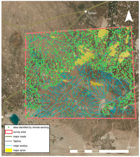
Figure 3.
Map showing all sites within the WHS identified by the satellite imagery survey, with main roads and natural features highlighted. This figure has previously been published in [18].
With one of the main foci of the WHS being the definition of site typologies based on their visible surface morphologies, it became clear that the precise documentation of these structures was of utmost importance. It has long been recognised by explorers and researchers in the Harra that its prehistoric structures can be divided into several distinct varieties, including hunting traps for wild gazelles known as “kites”, burial sites called “pendants”, and features termed “wheels” (sometimes “jellyfish”), which have variously been interpreted as habitation, animal corral, or ritual sites (Figure 4) [11,12,13,23]. However, already the use of very high-resolution satellite imagery showed that certain discrete site types had previously been grouped together and thus required a typological seriation. In particular, the sites known as “wheels” could be classed into two distinct categories—“true wheels”, which comprise a roughly circular or elliptical outline, inside which enclosures are divided by mostly straight walls, arranged like the spokes of a wheel, and “encircled enclosure clusters”, comprised of a randomly clustered set of sub-circular or sub-elliptical enclosures, with an irregular external outline encircled by a series of very small rectangular enclosures with right-angled corners (Figure 5). The identification during the 2017 fieldwork season of anthropogenic, and likely prehistoric, pathways of cleared basalt rock stretching across large distances of the landscape (a phenomenon already recognised by other researchers in the region [24,25]) provided a further research objective that could best be analysed by precise surface documentation [18,22].
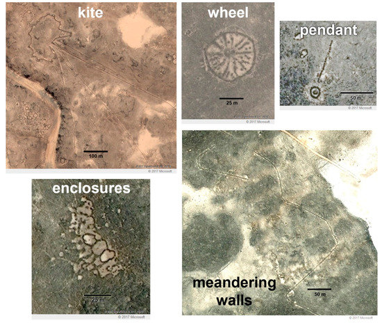
Figure 4.
Representative satellite images of the main previously identified prehistoric feature types found in the Harra. This figure has been modified from one previously published in [18].
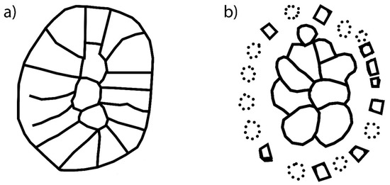
Figure 5.
Representative line drawings highlighting the differences between (a) “true wheels” and (b) “encircled enclosure clusters”. This figure has been modified from one previously published in [18].
The “Black Desert” constitutes a landscape of preservation—“Zone 1” as defined by Tony Wilkinson [26] (pp. 41–42)—featuring negligible natural transformation processes. Thus, the archaeological features in question all strongly impact its surface (in the form of either structural protrusions or anthropogenically caused depressions) in a way that serves as a very close proxy for their original form. Additionally, the relative chronology of anthropogenic impact on this landscape is closely related to its stratigraphy, thus significant data on this can be gathered from surface documentation alone. Furthermore, any disturbance of the surface “paving” of basalt blocks stands out visually due to the particularly high contrast and sharp definitions of black stones atop light brown loess. Finally, the archaeological features of the Harra extend across large distances, are located in areas that are hard to access, and yet are too small to allow for comprehensive analyses using the highest available satellite imagery resolutions. Together, these factors make the benefits of using a drone for their documentation obvious.
2. Materials and Methods
The WHS therefore initiated the process of collaborating with Jordan’s Royal Film Commission in October 2018 and submitted application forms early the following year to be ready for a first season with a drone in April 2019. The device used was a rotary-wing DJI Phantom 4 (2016 version), capable of flight times of around 28 min maximum per battery, a top range of 5 km, and equipped with a camera with 4000 × 3000-pixel photo and 4096 × 2160-pixel (4K) video capabilities [27]. The goals of this season regarding the drone focussed on the aerial documentation of a selection of “true wheels” and “encircled enclosure clusters”, as well as some preliminary attempts at recording pathways and sites’ environmental contexts. In total, seven such sites were vertically photographed in detail by planned flights using the DroneDeploy program, with ground markers recorded by a GPS device and an optical level to calibrate the DEMs derived from the imagery (see below). The environmental contexts of three of these were additionally photographed vertically, and three more were recorded similarly but without the ground markers due to their hard-to-access locations (see Section 4.1). In addition, these sites, and others in their vicinities, were documented by numerous oblique photographs and videos. The subsequent fieldwork season, in September 2019, in part continued this data collection strategy, with a further seven “true wheels” and “encircled enclosure clusters” recorded by vertical imagery with ground markers and one hard-to-access site without. However, a greater focus on environmental contexts meant that not only were the surroundings of four of these sites also recorded, but a further 12 were photographed as part of large-area vertical imaging. In addition, a region with abundant likely anthropogenic paths, clustered around two adjacent qe’an, was recorded in the same fashion, while as before, numerous oblique photographs and videos were also taken. Across both fieldwork seasons, elevations for the planned flights varied between 10 and 140 m. To mitigate the necessarily limited flight times of the device, four batteries were used and a gasoline-powered electricity generator as well as a multiple-battery charger transported in the vehicles used to drive to each site. This enabled the recharging of the drone batteries over the midday period (1.5–2 h), allowing for eight batteries’ worth of flight time per day.
The gathered data were subsequently processed in a number of ways, depending on the research questions wishing to be addressed (see Section 3). All digital manipulations were carried out using Agisoft Metashape Professional version 1.5.2, a photogrammetry tool that, along with its predecessor PhotoScan, has been used by many archaeological and cultural heritage projects for both large- and small-scale geospatial visualisations [28,29]. The most basic processing involved the creation of spatially accurate orthomosaics from the series of vertical images taken at each site, stitched together to form not only a detailed, but also precise, undistorted view of the landscape. Since virtually all photographs feature a degree of curved distortion towards their edges due to the shape of a camera lens, all drone images were taken with a minimum x-axis overlap of 75% and y-axis overlap of 65%. This means that the orthorectification process used at most the centre third of each image, where the distortion is minimal. Furthermore, since each image was geotagged in its metadata with unique GPS co-ordinates, each photograph could be accurately geolocated to create a locationally precise stitched image [30]. The resulting imagery is superior not only in terms of resolution, but also in terms of geometrical precision, to satellite imagery, which can feature significant distortions over small areas such as that of a single archaeological site [31]. The resolution of the orthomosaics processed from the WHS data varies between 1.0 and 4.2 cm/px, depending on the drone flight elevation for each plan.
Using a process called structure-from-motion, the recorded images can further be manipulated by one of a number of algorithms to estimate camera positions in relation to the photographed subject by point-matching multiple images, forming a point cloud from which digital elevation models (DEMs) and three-dimensional (3-D) models can be created [29,32]. The former outputs a shaded, coloured, or contour-lined visualisation of the elevation of the landscape in question. By entering the measured GPS co-ordinates and relative elevations of the ground markers (when they were used), and visually marking them on the imagery, these relative elevation models can be given absolute data in all three dimensions, allowing for an accurate calculation of scale and for their geolocation within the wider landscape [30]. The DEMs processed by the WHS have resolutions of between 2.0 and 33.3 cm/px. Using the point cloud, a digital wireframe mesh can be calculated, and subsequently “draping” the orthomosaic over this creates a photorealistic 3-D model that can be viewed from all sides, allowing for the elucidation of yet further details such as stratigraphic relationships and calculations of structural dimensions, volumes, and quantifiable topographic forms [33]. The technical details of each relevant drone flight and of the models processed from their data are listed in Table 1.

Table 1.
Technical details for each drone flight that produced data referenced in this paper.
3. Results
3.1. Vertical Orthomosaics
The geometrical precision of these created images already generated immensely useful data for the WHS. Since the project is attempting to use morphological site forms to create typologies which in turn could be related to differing time periods or purposes of construction and/or use, and therefore be used to preliminarily map a chronologically or ideas-based spread of human occupation across the Harra [18,21], such data are essential for obtaining the required levels of accuracy for the necessary analyses. They also brought to light interesting details on the forms of several sites—for example, while “true wheel” sites appear to be circular or elliptical with linear internal walls on very high resolution satellite imagery, the drone-derived orthomosaics showed their outlines to comprise a variety of shapes, from rounded pentagons and heptagons to irregular shapes with concave curves, and their internal walls to follow a combination of straight and curved paths (Figure 6). This heterogeneity of form was also found to be present amongst the “encircled enclosure clusters”, as although these sites are by their nature irregularly shaped, they were furthermore found to vary by the presence of very small enclosures adjacent to their walls, which at some sites appear internally, at some externally, at some both, and at others are absent (Figure 7).
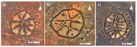
Figure 6.
Orthomosaics of three variant “true wheels”; (a) Site 652: A rounded pentagon with straight internal walls, (b) Site 691: A rounded heptagon with curved internal walls, and (c) Site 1978: An irregular shape with a concave curve on the south-western side and straight internal walls.
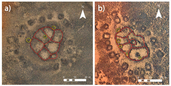
Figure 7.
Orthomosaics of two “encircled enclosure clusters”; (a) Site 2019 and (b) Site 977—highlighting the very small circular enclosures (in yellow), distinct from the main enclosures (in red).
The benefits of these images go beyond ascertaining the precise shapes of prehistoric structures however, as in a landscape such as the Harra they can also give information on relative chronologies. A good example of this is Site 1929, a “true wheel” that abuts the wall of a “kite”—since almost none of the sites in the survey area of the WHS have proper names, the project’s own numbering system is used here to distinguish them. On the orthomosaic, it becomes clear that the wall of the “kite” appears to stop a few metres from each edge of the external wall of the site (Figure 8). The interpretation of this follows straightforwardly: The “true wheel” post-dates the “kite”, and was therefore partly constructed using the readily available loose basalt blocks of its wall, a phenomenon noted at several sites by Kempe and Al-Malabeh [11] (p. 56). This correlates with the relative dating of “kites” conducted by other projects in the region, which place them as some of the oldest anthropogenic structures of the Harra, dating to at least the Early Neolithic, though often subsequently re-used, e.g., [24,34]. “Wheels”, on the other hand, have been dated to various periods between the Late Neolithic and Late Chalcolithic, but no earlier [24,35,36].
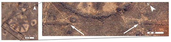
Figure 8.
Orthomosaic of “true wheel” Site 1929 showing the adjacent “kite” wall stopping short (white arrows) where its stones have likely been used to construct the later site.
3.2. Digital Elevation Models
The benefits of the drone-derived data are even more apparent when one examines the created DEMs. On a basic level, specific features of sites that were difficult or impossible to detect on either real-world imagery or on the ground became clearly apparent on the DEM, as has been recognised for several archaeological landscapes across the Near East, e.g., [37]. For example, while the shape of the small enclosures that surround “encircled enclosure cluster” Site 977 are sometimes recognisable as being rectangular on the orthomosaic, especially one example west and one north-west of the main site (see Figure 7b), the DEM makes this form recognisable for practically all of these features (Figure 9). Another example is the presence of cairns on top of walls of sites, which although instantly visible on the ground, do not appear clearly on vertical aerial imagery since they essentially constitute a pile of stones on top of other piled-up stones. On a DEM, however, they distinctly stand out from the background on account of their greater elevation, as illustrated by “true wheel” Site 652 (black circles on Figure 10). A further detail visible on the DEM of that site is a gap in the outer wall on its western side, possibly constituting an entrance, which is practically invisible on the orthomosaic due to the surrounding stone scatter (red circles on Figure 10).
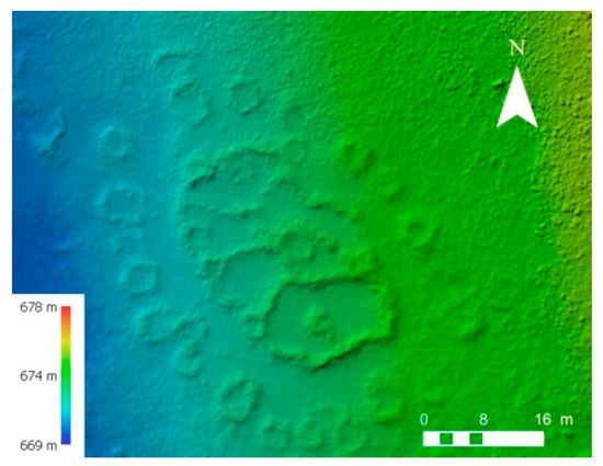
Figure 9.
DEM of Site 977 with the rectangular shapes of the small encircling enclosures clearly recognisable.
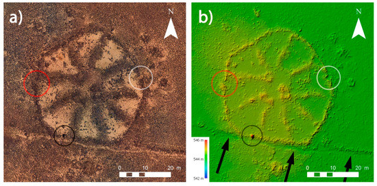
Figure 10.
(a) Orthomosaic and (b) DEM of Site 652. Highlighted features comprise a cairn (black circles), two gaps in the site’s outer wall (red and white circles), and a linear depression indicating a path along the adjacent kite tail (black arrows).
DEMs were also found to be useful for certain aspects of relative dating. In particular, the presence of walls preserved to a higher course of stones usually indicates a later structure that has been subject to fewer transformation processes, or a more recent modification of an earlier construction. A good example of this was found at “encircled enclosure cluster” Site 976, where the central and south-eastern enclosure have walls that are distinctly higher than the rest of the site (Figure 11). The hypothesis that this constitutes evidence for a later modification of the structure is further given weight by the fact that the south-eastern enclosure prominently protrudes from the otherwise relatively uniform outer wall of the site. While this in itself would not necessarily be an indication of a modification of the structure, when combined with the higher wall courses this interpretation can reasonably be made.
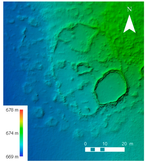
Figure 11.
DEM of Site 976, with the higher walls of the central and south-eastern enclosure clearly recognisable.
Certain sites’ footprints on DEMs revealed features that highlighted both specific features and relative dating evidence. One instance of this is “true wheel” Site 1745, the orthomosaic of which clearly shows a path that appears to abut its south-western edge (black arrows on Figure 12a). On the DEM, however, it is evident that this path runs across the site and emerges from its north-eastern edge to continue across the landscape, indicating that its use at least additionally post-dates the “true wheel” (Figure 12b). This example also highlights the co-directional nature of interpretations using drone-derived data, as once the DEM had been consulted, it became conspicuous that certain gaps in the internal walls of Site 1745, visible on the orthomosaic, constituted evidence for the path, though this had not been recognised before (white arrows on Figure 12). A more striking example of a DEM disclosing multiple datapoints can be found at Site 692, which on the orthomosaic appears as an unusual “true circle” with a linear wall protruding on its north-west side (Figure 13a). The DEM reveals the true nature of this site, however—a “pendant” (which consists of a single large cairn from which a linear arrangement of small cairns emanates – see Figure 4) superimposed upon a regular “true wheel” (Figure 13b). Once again, the benefit of hindsight after having viewed the DEM allowed the researchers to recognise the discrete features on the orthomosaic, despite this not being apparent beforehand. This evidence also ties in with other researchers’ documentations of pendants frequently overlying “wheels” [13] as well as C14 samples from instances of these features in Yemen, which date them to the first millennium BC [38] (pp. 329–335), much later than the Late Neolithic to Early (or even Late) Chalcolithic dates usually associated with “wheels” [24,35,36].
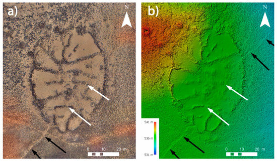
Figure 12.
(a) Orthomosaic and (b) DEM of Site 1745, with the path running through it indicated where visible by black arrows external to the site and by white arrows internal to it.
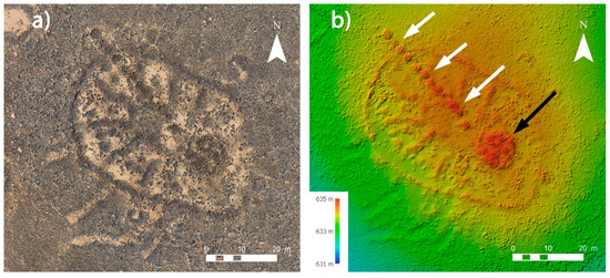
Figure 13.
(a) Orthomosaic and (b) DEM of Site 692. On the latter, the main cairn (black arrow) and linear arrangement of smaller cairns (white arrows) of the superimposed “pendant” site are clearly visible.
3.3. Three-Dimensional Models
The processing of drone imagery from the WHS to create 3-D models is still in its early stages; thus, they have been studied to a lesser degree than the data detailed above. Nevertheless, some preliminary benefits of these models, in ways that set them apart from both orthomosaics and DEMs, are already apparent. Specifically, as noted by Buccellati [39], they allow for particularly clear visualisations of stratigraphic details. One example of this is at Site 652, where to begin with, the cairn discerned on the DEM (see Section 3.2) is clearly visible on the 3-D model as a prominent conical structure (black circle on Figure 14). More impactful is the visualisation of a gap in the north-eastern side of the site’s outer wall, which was already noticeable on the DEM and to a lesser extent the orthomosaic (white circles on Figure 10). On the 3-D model, however, it is clear that this is not simply a gap, but a break created by subsequent digging, as the surface level clearly subsides in a concave form at that point (white circle on Figure 14). Therefore, the 3-D model provides additional information on transformation processes undergone by the site since its construction, and prevents a potentially erroneous conclusion that this gap in the wall was part of its initial construction plan.
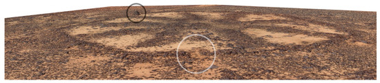
Figure 14.
Snapshot of the 3-D model of Site 652, looking west. The cairn (black circle) and break in the wall created by digging (white circle) are highlighted.
4. Discussion
4.1. Combining Processed Data with Fieldwork Data and Looking Beyond Sites
When used in combination and integrated with raw drone imagery and information recorded by ground-based fieldwork, the processed data detailed in Section 3 can be used to discern and record a number of further aspects related to the archaeological investigation of the “Black Desert”. On a basic level, the visualisation of the environmental contexts of each of the sites recorded by drone imagery, their spatial relationships to each other, and their proximity and accessibility to natural resources greatly aids large-scale landscape interpretations. One example of this is the region around Site 1745, which is located on the edge of a hill close to a wadi, a seasonal water source, and natural access route across the basalt desert. By viewing the orthomosaic in tandem with the DEM of the site’s environs, its prime position of only 70 m from the wadi, whilst being located on high ground not prone to flooding and furthermore directly adjacent to a smaller seasonal watercourse becomes apparent (Figure 15). A closer look at the individual vertical images as well as some oblique drone photographs additionally shows the presence of linear pathways leading from the hill on which Site 1745 lies to the wadi, apparently interspersed with regular stone breaks (white arrows on Figure 15 and Figure 16b,c). Already during the 2017 fieldwork season, this area was visited on the ground and the interpretation was made that this feature constitutes a path with deliberately placed breaks to create stair treads for increasing the ease of movement up and down the hill (Figure 16a) [18]. The drone imagery therefore not only clearly confirms that this hypothesis holds true over the entire trajectory of the path, but also that the path itself is undoubtedly anthropogenic and not hydrological in origin, as it is located uphill from the natural course of water along the small valley (black arrows on Figure 15 and Figure 16b,c).
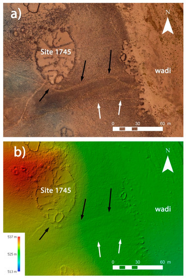
Figure 15.
(a) Orthomosaic and (b) DEM of the environment of Site 1745. The small watercourse (black arrows) and “stepped” anthropogenic path (white arrows) are highlighted.
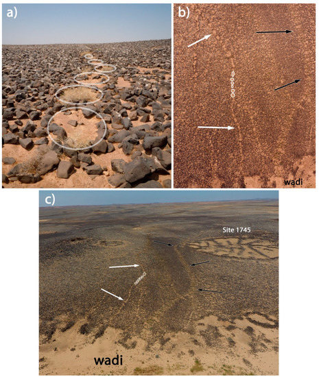
Figure 16.
(a) Ground photograph, (b) vertical drone photograph, and (c) oblique drone photograph of the environment of Site 1745. The small watercourse (black arrows) and “stepped” anthropogenic path (white arrows) are highlighted. The same six representative “stair treads” are circled in white on all images.
Such a visualisation of environmental contexts can also be carried out over multiple sites and across a large area. This was attempted by conducting a planned drone flight at a location comprising a 540-m long and between 100 and 160-m wide promontory of basalt desert that extends like a peninsula into a large qa’a, next to where it is joined by a large wadi. This geographical feature contains at least six sites, including a “kite”, two different locations of enclosures, one location with small double-apsed “ghura huts” (see [40] (pp. 179–181)), and eight large cairns likely representing “tower tombs” (see [41]), two of which are connected by a line of smaller cairns to form a type of “pendant”. The created orthomosaic visualises the plethora of sites present at this location, doubtless desirable due to its accessibility across the qa’a, access to seasonal water from the wadi, and abundant presence of basalt construction material (Figure 17a). The “tower tombs” in particular were not recognised on satellite imagery, but first recorded in the field; thus, the orthomosaic proved useful in retroactively ascertaining their spatial relationships. However, the DEM showed their locations much more clearly, and additionally provided evidence for further “tower tombs” not recognised in the field, and thus not visited (black circles on Figure 17b). With the benefit of hindsight, it would have been beneficial to process the drone data before carrying out the ground fieldwork so as not to miss out on investigating the full corpus of sites. This therefore showcases another use of drone-derived data: For planning fieldwork at locations surmised to comprise sites too small to be recognisable on the highest available resolution of satellite imagery. The orthomosaic and DEM also highlighted a number of other relationships between sites and their environments, such as the locations of enclosures exclusively on the edges of the basalt “peninsula” but “tower tombs” and smaller cairns along the summit of its ridge—a common property of pre-Islamic burial sites in the Harra [41]—and the location of the “kite” in a depression with its southern long wall running directly along the contour of a hill edge (black arrows on Figure 17), thus using the natural landscape to its advantage to aid in directing the movement of wild game into its enclosure—a frequent phenomenon of these features [11] (pp. 54–55).
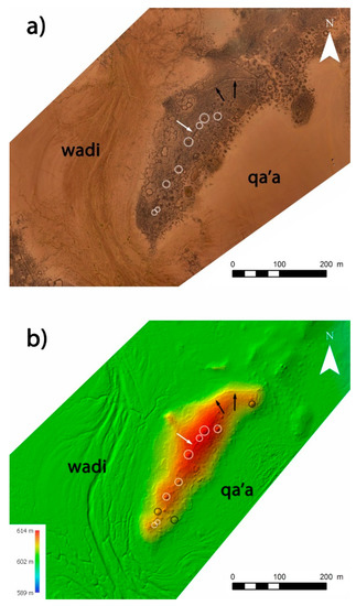
Figure 17.
(a) Orthomosaic and (b) DEM of a basalt “peninsula” jutting into a large qa’a (to the east) and wadi (to the west). The eight probable “tower tombs” identified in the field are circled in white, while three further likely examples subsequently identified on the DEM are circled in black. The line of smaller cairns connecting two of the “tower tombs” (white arrow) and southern wall of a “kite” (black arrows) are also highlighted.
The drone-derived data, and in particular the DEMs, were further found to be useful for the recognition and mapping of the likely anthropogenic paths across the basalt mentioned in Section 1. In their 2018 publication on the use of satellite imagery for informing and complementing the WHS fieldwork, the project directors highlighted the differences between modern roads, “sheep tracks” caused by the modern movement of livestock, and likely prehistoric paths in terms of trajectory, width, and connectivity to ancient sites [18] (pp. 12–15). High-resolution DEMs add a new method for discerning these features from each other due to their differing topographical impacts on the landscape. To begin with, modern roads can be recognised not only by their greater linearity and width than other routes, but also by the continuous presence of small hillocks along their entire course, usually along a single edge (Figure 18). These represent regular piles of basalt stones cleared by bulldozers to create the roads. More significant, however, is the clear difference in topographic signature between “sheep tracks” and likely ancient paths, as despite some variances in width and linearity, these can appear fairly similar on satellite or even drone photographs. A good example can be found at the “true wheel” Site 1129, around which numerous paths are visible on the orthomosaic, some crossing and some closely bypassing the site (Figure 19a). However, only one of these produces a clear linear hollow on the DEM, while the rest appear practically absent in the topography (Figure 19b). This path, when viewed on very high-resolution satellite imagery, is also the only one that can be traced over a longer distance, running roughly eastwards via several small qe’an, awdiya, and sites to finally emerge at a very large qa’a (Figure 20). Whether the topographic signature of this path is entirely due to its more intensive use over longer periods of time than the “sheep tracks” or is owed in part to increased hydrological processes due to its greater age and width cannot be ascertained from this remote sensing data alone. Whichever is the case, however, it speaks for a path that is older, more deliberately created, and with a more uniformly utilised trajectory than the other ones around Site 1129.
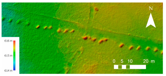
Figure 18.
DEM of a modern vehicle road, with the small piles of bulldozed stones clearly recognisable along its southern edge.
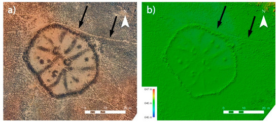
Figure 19.
(a) Orthomosaic and (b) DEM of Site 1129. Although many paths are visible on the former, only the path indicated by black arrows has a significant signature on the DEM.
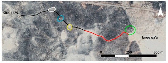
Figure 20.
Satellite image of the landscape east of Site 1129, with the course of the path discernible on Figure 19b traced (black line). Starting from that site and heading eastwards, it crosses a small qa’a (white circle), an enclosure site (blue circle), and a second small qa’a (yellow circle) before joining a slightly larger qa’a and continuing via a wadi (red line) to emerge at a very large qa’a by an “encircled enclosure cluster” site (green circle).
A further example of this can be found along the walls of “kites”. As the presence of linear clearances next to these walls is a self-evident necessity due to the removed stones for their construction, and can be recognised even on high-resolution satellite imagery, the project directors have formerly argued that they could be used for human circulation across the landscape [18] (p. 15). However, the clear presence of linear hollows on DEMs next to some of these walls provides concrete evidence that they have been, and perhaps continue to be, traversed for accessing dense basalt landscapes, such as around Site 652 (black arrows on Figure 10b). As such, it is reasonable to hypothesise that, pending further investigation, DEMs could be used to aid the discerning of ancient paths from modern ones across the Harra, and to determine which kite tails were used as circulation pathways.
Another widely recognised benefit of UAVs is their potential for documenting threats to ancient sites, and therefore contributing to the monitoring of cultural heritage, e.g., [4,37] and specifically in Jordan [42]. This is also the case in the Harra, where possible damage to the prehistoric structures usually comes in the form of bulldozing for road construction or prospective mining activities. Drone imagery of both individual sites and large areas enables not only the recording of this, but also the rapid recognition of any alterations in existing threats. Thus, for example, the orthomosaic of Site 1972 (Figure 21) and an oblique photograph of Site 1326 (Figure 22) show the presence of bulldozed tracks that are in danger of destroying at least part of each site. Since Jordan has a centralised database for the recording and monitoring of its heritage, called MEGA-Jordan [43], these data can be added to that system in the form of “Site Monitoring Reports”, providing a clear visualisation of the damage. Furthermore, should the threat or damage levels have been found to change upon subsequent visits, the nature and extent of the change can easily be ascertained by carrying out another drone flight and directly comparing the new imagery with the old.
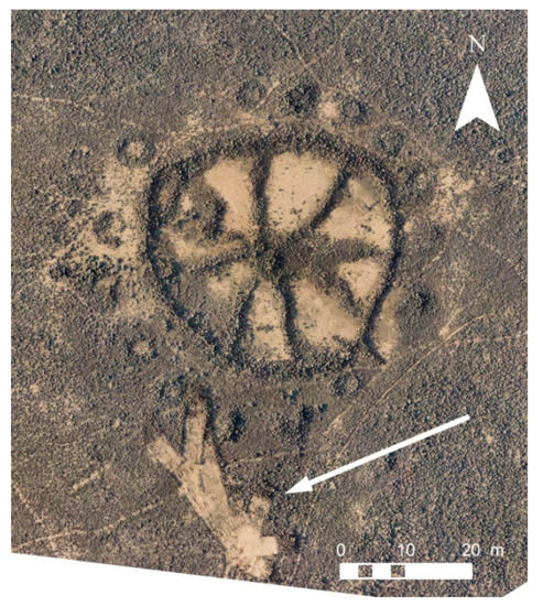
Figure 21.
Orthomosaic of Site 1972 with the modern bulldozer damage and potential threat indicated by a white arrow.
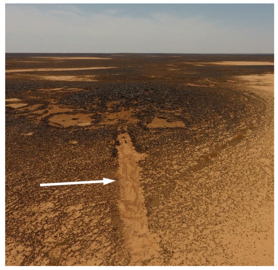
Figure 22.
Oblique drone photograph of Site 1326 with the modern bulldozer damage and potential threat indicated by a white arrow.
Finally, one application of the capabilities of a drone that is of particular use in the “Black Desert” is the documenting of sites that are practically inaccessible on the ground. Traversing the densest basalt landscape of the Harra is impossible by vehicle and very tiresome on foot, requiring a significant amount of human effort and project time. Using satellite imagery, it has been possible to plan vehicle routes to many more locations than expected, but nevertheless around 20% of sites visible on remote sensing remain over one kilometre away from the nearest vehicle-accessible area [18] (p. 16). By sending a drone flying over potentially interesting sites (as determined on satellite imagery), the radius of “accessible” locations in the dense basalt is increased, in the case of the DJI Phantom 4 to a maximum of 5 km, depending on the terrain and length of time required to record the sites in question. A good example of this is Site 652, which has been used several times in this paper to showcase the benefits of drone-derived data (Section 3; Figure 6a, Figure 10 and Figure 14), but is located around 1300 m from the nearest place a vehicle can reach. It should be emphasised that recording a site exclusively from the air is no replacement for an in-tandem ground visit, no matter in how great a detail it can be captured. However, for the production of data for morphological comparisons and for the planning of potential ground visits (in other words, determining if the great effort required to reach the site is likely to be worth it) it is of immense value.
4.2. Future Prospects: Quantification and Statistic Modelling
While the analyses detailed above already provide an in-depth showcase of the great potential of drone-derived data for the WHS, they are not exhaustive. One of the further possibilities that the level of detail provided makes feasible, and is currently being worked on, is that of quantifying the physical shapes of sites. This process would greatly increase the confidence levels of the preliminary mapping of the purpose, chronology, or culture of human spread across the Harra based on the visual appearances of sites. For example, even if a statistically significant correlation could be determined between period of occupation and “true wheels” that differs from that of “encircled enclosure clusters”, the issue of the subjectivity of categorising any given site as belonging to one or the other type remains. By selecting specific aspects of these site types that are considered to define them, quantifying these, and comparing the objective measurements with the perceived categorisations, we can determine the extent of their subjectivity.
For instance, we can consider one supposed property of “encircled enclosure clusters”: That their outlines are irregular compared to those of “true wheels”. This would mean that the longest chord (longest internal straight line from one edge to another) of any site of the former type should show only a weak correlation to its area—specifically, the area should be relatively smaller when compared to a hypothetical “true wheel” with the same chord length (Figure 23). Conversely, the longest chords of the circular or oval “true wheels” ought to show a stronger correlation with their areas. A preliminary analysis conducted by measuring the parameters in question on the orthomosaics of 38 of these sites produced promising results. The length of the longest internal chords of “true wheels” do indeed appear to clearly correlate positively with their areas (with one outlier); conversely, those of “encircled enclosure clusters” show a weaker correlation, while also being almost consistently relatively longer (Figure 24). This analysis, and others made possible by the drone-derived data, is to be a focus of the ongoing WHS project.
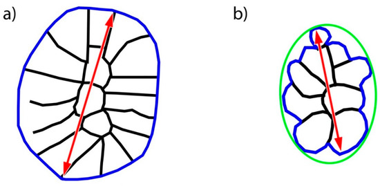
Figure 23.
Representative line drawings of (a) a “true wheel” and (b) an “encircled enclosure cluster”, with their outlines highlighted in blue and longest chord shown in red. It is evident that a hypothetical “true wheel” of the same chord length as site (b) would have a significantly larger area (as indicated by the green ellipse), thus this mathematical relationship can be used to attempt to distinguish these site types.
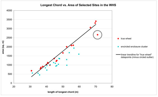
Figure 24.
Graph showing the relationship between longest chord length and area of a selection of “true wheels” and “encircled enclosure cluster” sites. The linear trendline for the former shows a strong correlation of these two datapoints (with the exception of one outlier, circled). By contrast, the “encircled enclosure clusters” show a much weaker correlation and, as expected, mostly have relatively longer chords.
5. Conclusions
The use of a drone in the data-gathering activities of the WHS opens up a large number of possibilities for remote sensing analyses, which in turn are intended to be used to inform further ground-based fieldwork. While some of the factors of this success are fairly unique to Jordan’s “Black Desert”, most of the methodologies will be of benefit to and results replicable in a large variety of landscapes of preservation with low levels of natural and anthropogenic transformation processes postdating the archaeology in question. In regions that are furthermore difficult to access, employing these devices provides an additional bonus for recording and planning fieldwork at remote sites. Therefore, the capabilities of UAVs discussed here are both a case study of the benefits of this transformative technology for the discipline of archaeology in general and a specific example of its practicality for a particular type of landscape where, at least in Jordan, it has thus far been underused.
Funding
The two 2019 fieldwork seasons of the Western Harra Survey were made possible by funding from the Institut Français du Proche-Orient (IFPO), Archéorient—UMR 5133 CNRS, and the Research Foundation—Flanders (FWO). The project in general has received funding from the FWO and the European Union’s Horizon 2020 research and innovation programme under the Marie Skłodowska-Curie grant agreement No 665501.
Acknowledgments
The Western Harra Survey is a co-directed project by the author and Marie-Laure Chambrade, CNRS, Archéorient, Lyon, France. Thanks go to the Department of Antiquities of the Kingdom of Jordan (DoA), the Royal Film Commission, the General Command of the Jordanian Armed Forces, the Institut Français du Proche-Orient (IFPO), and the Council for British Research in the Levant (CBRL) for facilitating the import, storage, transport, and export of our drone. Specific thanks go to our representatives Usama Eid and Bilal al-Boreni (DoA), Ahmad and Musa (Jordanian Army), and Ghazi Hijazi (IFPO). Finally, a special thank you to Bjoern Menze of the Institute of Medical Engineering of the Technical University Munich (IMETUM) for lending us the drone equipment, which made this entire research possible in the first place.
Conflicts of Interest
The author declares no conflict of interest. The funding sponsors had no role in the design, execution, interpretation, or writing of the study.
References
- Bewley, R. Aerial Archaeology. The First Century. In Aerial Photography and Archaeology 2003: A Century of Information; ARGU 4; Bourgeois, J., Meganck, M., Eds.; Academia Press: Gent, Belgium, 2005; pp. 15–35. [Google Scholar]
- Campana, S. Drones in Archaeology. State-of-the-art and Future Perspectives. Archaeol. Prospect. 2017, 24, 275–296. [Google Scholar] [CrossRef]
- Eisenbeiss, H.; Sauerbier, M.; Zhang, L.; Grün, A. Mit dem Modellhelikopter über Pinchango Alto. Geomatik Schweiz 2005, 103, 510–515. [Google Scholar] [CrossRef]
- Themistocleous, K. The Use of UAVs for Cultural Heritage and Archaeology. In Remote Sensing for Archaeology and Cultural Landscapes. Best Practices and Perspectives Across Europe and the Middle East; Hadjimitsis, D.G., Themistocleous, K., Cuca, B., Agapiou, A., Lysandrou, V., Lasaponara, R., Masini, N., Schreier, G., Eds.; Springer Nature Switzerland AG: Cham, Switzerland, 2020; pp. 241–269. [Google Scholar] [CrossRef]
- Fernández-Hernandez, J.; González-Aguilera, D.; Rodríguez-Gonzálvez, P.; Mancera-Taboada, J. Image-Based Modelling from Unmanned Aerial Vehicle (UAV) Photogrammetry: An Effective, Low-Cost Tool for Archaeological Applications. Archaeometry 2015, 57, 128–145. [Google Scholar] [CrossRef]
- Kennedy, D.L. Pioneers above Jordan: Revealing a prehistoric landscape. Antiquity 2012, 86, 474–491. [Google Scholar] [CrossRef]
- APAAME—Finding the Past Frame by Frame. Available online: http://www.apaame.org (accessed on 29 September 2020).
- Kennedy, D.; Bewley, R. Aerial archaeology in Jordan. Antiquity 2009, 83, 69–81. [Google Scholar] [CrossRef]
- Hill, A.; Rowan, Y. Droning on in the Badia: UAVs and Site Documentation at Wadi al-Qattafi. Near East. Archaeol. 2017, 80, 114–123. [Google Scholar] [CrossRef]
- The Royal Film Commission Jordan|Who We Are. Available online: http://www.film.jo/Contents/Who-We-Are.aspx (accessed on 29 September 2020).
- Kempe, S.; Al-Malabeh, A. Hunting kites (‘desert kites’) and associated structures along the eastern rim of the Jordanian Harrat: A geo-archaeological Google Earth images survey. ZOrA 2010, 3, 46–86. [Google Scholar]
- Maitland, P. The ‘Works of the Old Men’ in Arabia. Antiquity 1927, 1, 197–203. [Google Scholar] [CrossRef]
- Kennedy, D. The “Works of the Old Men” in Arabia: Remote sensing in interior Arabia. J. Archaeol. Sci. 2011, 38, 3185–3203. [Google Scholar] [CrossRef]
- Betts, A.V.G. Excavations at Jawa 1972–1986; Edinburgh University Press: Edinburgh, UK, 1991. [Google Scholar]
- Betts, A.V.G. The Harra and the Hamad: Excavations and Survey in Eastern Jordan; Sheffield Archaeological Monographs 9; Sheffield Academic Press: Sheffield, UK, 1998. [Google Scholar]
- Corbett, G.J.; Keller, D.R.; Porter, B.A.; Tuttle, C.A. Archaeology in Jordan, 2012 and 2013 Seasons. Am. J. Archaeol. 2014, 118, 627–676. [Google Scholar] [CrossRef]
- Akkermans, P.M.M.G. Living on the Edge or Forced into the Margins? Hunter-Herders in Jordan’s Northeastern Badlands in the Hellenistic and Roman Periods. J. East. Mediterr. Archaeol. Herit. Stud. 2019, 7, 412–431. [Google Scholar] [CrossRef]
- Smith, S.L.; Chambrade, M.-L. The Application of Freely-Available Satellite Imagery for Informing and Complementing Archaeological Fieldwork in the “Black Desert” of North-Eastern Jordan. Geosciences 2018, 8, 491. [Google Scholar] [CrossRef]
- Smith, S.L. Surveying the Black Desert: Investigating Prehistoric Human Occupation in North-Eastern Jordan. ArchéOrient Blog 2017. Available online: http://archeorient.hypotheses.org/7882 (accessed on 29 September 2020).
- Chambrade, M.-L.; Smith, S.L. Western Harra Survey Project. Archaeol. Jordan 2018, 1, 7–8. [Google Scholar]
- Smith, S.L. The Late Chalcolithic and Early Bronze Age of the Badia and Beyond: Implications of the Results of the First Season of the Western Harra Survey. In Landscapes of Survival. The Archaeology and Epigraphy of Jordan’s North-Eastern Desert and Beyond; Akkermans, P.M.M.G., Ed.; Sidestone Press: Leiden, The Netherlands, 2020; in press. [Google Scholar]
- Smith, S.L.; Chambrade, M.-L.; Alhussain, I. Western Harra Survey Project, Archaeology in Jordan in Press, 2. Available online: http://www.acorjordan.org/archaeology-jordan-aij (accessed on 26 October 2020).
- Betts, A.V.G. “Jellyfish”: Prehistoric desert rockshelters. ADAJ 1982, 26, 183–188. [Google Scholar]
- Akkermans, P.M.M.G.; Huigens, H.O.; Brüning, M.L. A landscape of preservation: Late prehistoric settlement and sequence in the Jebel Qurma region, north-eastern Jordan. Levant 2014, 46, 186–205. [Google Scholar] [CrossRef]
- Huigens, H.O. The identification of pathways on harra surfaces in north-eastern Jordan and their relation to ancient human mobility. J. Arid Environ. 2018, 155, 73–78. [Google Scholar] [CrossRef]
- Wilkinson, T.J. Archaeological Landscapes of the Near East; The University of Arizona Press: Tucson, AZ, USA, 2003. [Google Scholar]
- DJI Phantom 4—Specs, FAQ, Tutorials and Downloads. Available online: https://www.dji.com/phantom-4/info (accessed on 29 September 2020).
- Verhoeven, G. Taking Computer Vision Aloft—Archaeological Three-dimensional Reconstructions from Aerial Photographs with PhotoScan. Archaeol. Prospect. 2011, 18, 67–73. [Google Scholar] [CrossRef]
- Jones, C.A.; Church, E. Photogrammetry is for everyone: Structure-from-motion software user experiences in archaeology. J. Archaeol. Sci. Rep. 2020, 30, 102261. [Google Scholar] [CrossRef]
- Sapirstein, P.; Murray, S. Establishing Best Practices for Photogrammetric Recording During Archaeological Fieldwork. J. Field Archaeol. 2017, 42, 337–350. [Google Scholar] [CrossRef]
- Casana, J.; Cothren, J.; Kalayci, T. Swords into Ploughshares: Archaeological Applications of CORONA Satellite Imagery in the Near East. Internet Archaeol. 2012, 32. [Google Scholar] [CrossRef]
- Green, S.; Bevan, A.; Shapland, M. A comparative assessment of structure from motion methods for archaeological research. J. Archaeol. Sci. 2014, 46, 173–181. [Google Scholar] [CrossRef]
- Buccellati, F. 3D Models as Vehicles for Archaeological Research: Stratigraphy, Emplacement and Construction. Studia Eblaitica 2016, 2, 205–212. [Google Scholar]
- Betts, A.V.G. Dhuweila: Area survey. In The Harra and the Hamad: Excavations and Survey in Eastern Jordan; Sheffield Archaeological Monographs 9; Betts, A.V.G., Ed.; Sheffield Academic Press: Sheffield, UK, 1998; pp. 191–205. [Google Scholar]
- Rollefson, G.O.; Athanassas, C.D.; Rowan, Y.M.; Wasse, A. First chronometric results for ‘works of the old men’: Late prehistoric ‘wheels’ near Wisad Pools, Black Desert, Jordan. Antiquity 2016, 90, 939–952. [Google Scholar] [CrossRef]
- Athanassas, C.D.; Rollefson, G.O.; Kadereit, A.; Kennedy, D.; Theodorakopoulou, K.; Rowan, Y.M.; Wasse, A. Optically stimulated luminescence (OSL) dating and spatial analysis of geometric lines in the Northern Arabian Desert. J. Archaeol. Sci. 2015, 64, 1–11. [Google Scholar] [CrossRef]
- Starková, L. Toward a High-Definition Remote Sensing Approach to the Study of Deserted Medieval Cities in the Near East. Geosciences 2020, 10, 369. [Google Scholar] [CrossRef]
- De Maigret, A. Arabia Felix—An Exploration of the Archaeological History of Yemen, 3rd ed.; Stacey International: London, UK, 2009. [Google Scholar]
- Buccellati, F. What Might a Field Archaeologist Want from an Architectural 3D Model? In How Do We Want the Past to Be? On Methods and Instruments of Visualizing Ancient Reality, Regenerating Practices in Archaeology and Heritage 1; Micale, M.G., Nadali, D., Eds.; Gorgias Press: Piscataway, NJ, USA, 2015; pp. 157–169. [Google Scholar]
- Rowan, Y.; Rollefson, G.O.; Wasse, A.; Abu-Azizeh, W.; Hill, A.C.; Kersel, M.M. The “land of conjecture”: New late prehistoric discoveries at Maitland’s Mesa and Wisad Pools, Jordan. J. Field Archaeol. 2015, 40, 176–189. [Google Scholar] [CrossRef]
- Akkermans, P.M.M.G.; Brüning, M.L.; Arntz, M.; Inskip, S.A.; Akkermans, K.A.N. Desert tombs: Recent research into the Bronze Age and Iron Age cairn burials of Jebel Qurma, north-east Jordan. Proc. Semin. Arab. Stud. 2020, 50, 1–17. [Google Scholar]
- Kersel, M.; Hill, A. The (W) Hole Picture: Responses to a Looted Landscape. Int. J. Cult. Property 2019, 26, 305–329. [Google Scholar] [CrossRef]
- MEGA-Jordan. Available online: http://www.megajordan.org (accessed on 29 September 2020).
Publisher’s Note: MDPI stays neutral with regard to jurisdictional claims in published maps and institutional affiliations. |
© 2020 by the author. Licensee MDPI, Basel, Switzerland. This article is an open access article distributed under the terms and conditions of the Creative Commons Attribution (CC BY) license (http://creativecommons.org/licenses/by/4.0/).