Abstract
Pedestrian accessibility of public space is a crucial basis for ensuring public equality in sharing resources and enhancing spatial vitality and utilization efficiency. This research applied complex network theory to examine pedestrian accessibility in industrial heritage renovated public spaces, integrating the node efficiency model with an improved gravity model to propose the node accessibility model. By taking Xi’an Banpo International Art District as a case study, 13 public spaces were selected and categorized into categories to identify the current characteristics and key deficiencies. The results showed that public space pedestrian accessibility shows a positive correlation with the quality of the spaces, though individual nodes may deviate due to network effects. Correlation analyses indicated that an appropriate road setting in public spaces contributed to positive pedestrian accessibility of the whole district; however, poor spatial environment and lack of arts and cultural atmosphere were key reasons for low pedestrian accessibility. In response, four strategies for improving the pedestrian accessibility of public spaces in industrial heritage renovated districts were proposed, which included industrialization of public transport space, peripheral space integration, entrance space transition, and internal space enhancement. This study provides scientific methodology and theoretical guidance for the optimization of public space in industrial heritage renovated projects and contributes new insights into industrial heritage preservation and urban space renewal.
1. Introduction
In recent decades, China has entered the post-industrialization phase; industry continues to be optimized and upgraded, and with it comes the restructuring and transformation of industrial production space within cities. For the past few years, as inventory optimization has become an inevitable choice for sustainable urban development in China, the abandoned industrial production sites, which have occupied a large amount of urban inventory space, have increasingly attracted attention for its preservation and adaptive reuse. Some of these abandoned spaces contain buildings, architectural spaces, or industrial artifacts with high historical, social, economic, technological, and esthetic values [], which are known as industrial heritage. As an important part of cultural heritage, industrial heritage, with its unique spatial characteristics and cultural connotations, records the results of the interaction between human activities and the natural–social environments during the period of industrial prosperity, as well as the social, economic, political, cultural, and folklore information of that era []. These heritages are not only a precipitation of urban space and social structure, but also a witness of the development of industrial culture, condensing rich memories of the times, and playing a pivotal role in driving economic revitalization and fostering innovation in urban development []. The significance of industrial heritage renewal and reuse in enriching the new industrial culture cannot be ignored []. There is no lack of successful cases of renovation and reuse of industrial heritage in the world, such as the High Line in Manhattan, Zeche Zollverein in Essen, Westergasfabriek of Amsterdam, 798 Art District in Beijing [], Shanghai West Bund [], etc., which demonstrate that the rational revitalization and reuse of industrial heritage have become central to contemporary urban regeneration and will continue to play a critical role in the future development of cities.
Arts and cultural districts are one of the mainstream directions for revitalization and reuse of industrial heritage. Initially, artists were attracted to abandoned industrial sites due to their low rents and spaciousness, repurposing them for reuse [], as seen in case of Beijing 798 Art District and Redtory Art & Design Factory. Over time, these areas accumulated more artistic activities and formed vibrant art communities. At the beginning of the 21st century, such cultural communities attracted widespread attention and became fashionable places to visit. It was also under such market demand that the government increased policy support and financial investment, and arts and culture districts gradually became a typical mode of industrial heritage renovation. Successful renovation projects become not only local cultural landmarks, but also an important part of urban public spaces, playing a crucial role in citizens’ daily lives. However, over time, challenges have emerged. After a period of prosperity with an influx of tourists, some industrial heritage renovated arts and cultural districts have entered a phase of decline. This is characterized by a sharp decrease in visitor numbers, scarce human activity, overgrown weeds in outdoor spaces, as well as dirty and cluttered interior environments filled with piled-up debris. These phenomena lead to the overall inactivation of the entire district and reduced revenue, which in turn results in lethargic management and creates a vicious cycle.
However, as a significant and valuable part of the urban existing stock of spaces, it is essential to address the existing problems in these districts. The fundamental solution lies in re-attracting visitors to the spaces, thereby encouraging them to frequent and utilize the various important public space nodes within the district. In this process, accessibility is a prerequisite for the successful implementation of industrial tourism activities. Internal transportation accessibility within the districts, as a core influencing factor, plays a significant role []. The location resources occupied by different spaces vary: those with higher accessibility indices tend to have better locational advantages, leading to higher utilization rates; in contrast, some public spaces within arts and culture districts, particularly those with low accessibility, exhibit a phenomenon described as “surviving without vitality,” characterized by low utilization rates []. As visitors predominantly access public spaces on foot, analyzing pedestrian accessibility is especially critical []. Therefore, it is necessary to identify spatial nodes within the district that lack adequate pedestrian accessibility, conduct an in-depth analysis of their existing issues, and propose targeted optimization strategies to activate spatial potential and improve user experience overall.
Previous research on the pedestrian accessibility of industrial heritage sites has primarily focused on qualitative rather than quantitative approaches. Predominantly qualitative research focuses on the importance of accessibility from the perspectives of sites’ historical progression [,,], surrounding urban development [,], and local policy making []. Some other studies have also focused on the quantitative perspective, and commonly used approaches include space syntax [,,], the Ga2SFCA method [,,], as well as Social Network Analysis [,,] to conduct quantitative analyses of spatial accessibility. However, space syntax primarily focuses on the spatial configuration itself, calculating metrics such as integration and connectivity through topological relationships, yet it struggles to incorporate non-topological attributes of space such as function, environment, and culture. The Ga2SFCA method, grounded in supply–demand relationships and emphasizing social equity, does not account for the interactions between spatial nodes. In addition, in these studies, industrial heritage sites are generally considered as entire urban plots, with their significance and transportation accessibility discussed as a whole at the urban scale. However, the public space system of industrial heritage is essentially a network of perceived quality composed of multiple heterogeneous subspaces. Existing research paradigms hardly reveal the true accessibility differences among different nodes within the network, nor their structure-related causes. Renovated industrial heritage sites have introduced a wider range of public activities for both residents and visitors to participate in [], which are facilitated by a series of relatively independent yet interconnected public spaces. These public spaces are not only included in industrial heritage sites but also an indispensable part of urban public space systems. Therefore, the core innovation of this study lies in (1) shifting the research scale from the macroscopic “urban plot” level to the microscopic “public space node” level; (2) incorporating interactions between spaces into the analytical framework; and (3) quantifying qualitative perceptual attributes of space, such as historical value, arts and culture atmosphere, and spatial environment, and embedding them into the construction of the network model, thereby integrating the unique humanistic dimensions of industrial heritage into quantitative analysis.
Public spaces refer to outdoor and indoor areas designed for public use in both daily and social life. In the context of industrial heritage renovated arts and culture districts, public spaces are those with public attributes that serve the district and its neighboring communities []. Specifically, this paper focuses on outdoor open spaces within and surrounding the arts and culture district, which can be used by tourists. These spaces are indispensable components, offering a variety of experiences to different groups of people in terms of functionality, humanism, and artistic expression []. In view of the dual nature of public spaces, both independent and interconnected, this study introduces complex network theory for corresponding research. Complex network theory systematically describes the interrelationships between natural, social, and technological systems. It can be defined as systems in which constituent units are abstracted as nodes and interactions between these units are represented as edges, encompassing a large number of constituent units or subsystems. In recent years, the theory is widely applied in the field of transportation networks [,,], as well as the study of spatial structures in urban or regional scale [,]. Additionally, the concept of node accessibility originated from classical location theory. In 1959, the scholar Hansen first introduced the concept of node accessibility in his study of urban land use, defining it as the extent of opportunities for interaction generated by nodes within a transport network []. The pedestrian accessibility discussed in this paper refers to an index that evaluates the ease of walking from one public space node to another within an industrial heritage renovated arts and culture district. It embodies the spatial and temporal relationships between nodes in terms of time distance and mutual accessibility [].
Consequently, this study applies complex network theory to the public spaces within industrial heritage renovated arts and culture districts, conceptualizing both peripheral and internal public spaces as part of a complex network system. This study improves the node efficiency model in complex network theory by incorporating interactions between public spaces and the intrinsic quality of the spaces themselves. By taking Banpo International Art District in Xi’an as a case study, this study examines 13 public spaces, calculates the accessibility of each node, identifies existing problems, and proposes targeted strategies aimed at promoting the overall revitalization of industrial heritage sites and the renewal of urban spaces.
2. Materials and Methods
2.1. Research Framework
This study consists of 6 parts, as shown in Figure 1:
- (1)
- Pedestrian accessibility model construction: This research applied complex network theory to examine pedestrian accessibility in industrial heritage renovated public spaces, integrating the node efficiency model with an improved gravity model to propose the node pedestrian accessibility model.
- (2)
- Data collection: By taking Banpo International Art District in Xi’an as a case study, on-site research was conducted by surveying 124 visitors who walked from nearby transport stations to the public spaces of the art district to define the scope of study area. Based on the definitions of public space provided in the literature, this study selected 13 public spaces within the scope as research subjects. The shortest distance between two spaces was obtained in Baidu Maps V21, with the starting and end points positioned at the center of mass for each public space. Moreover, the evaluation criteria for space quality were based on expert consulting, public opinions, extensive literature reviews [,,,,,], standards and specification [,,], and practical case studies. To test the reliability of this evaluation system, a criticality questionnaire was developed, and 35 industry experts were invited to assess the importance of selected factors across 5 dimensions. The research employed an on-site questionnaire to gather visitors’ evaluations of each space, collecting a total of 124 valid responses.
- (3)
- Data processing: Based on the data obtained above, a public space network was constructed with public spaces as nodes and road connections as lines; the quality evaluation index system of public space and weighting of each impact factor were determined, and the total quality of each public space and the quality in each aspect were calculated; moreover, based on the shortest distance between the two spaces and the average pedestrian speed, the shortest travel time was calculated.
- (4)
- Pedestrian accessibility calculation: Pedestrian accessibility in each space was described by 6 indicators, namely, PAA1 (total quality node pedestrian accessibility), PAB1 (road setting node pedestrian accessibility), PAB2 (historic value node pedestrian accessibility), PAB3 (spatial environment node pedestrian accessibility), PAB4 (arts and culture node pedestrian accessibility), and PAB5 (functional requirement node pedestrian accessibility).
- (5)
- Pedestrian accessibility analysis: Based on the different functions of selected nodes, this study categorized the 13 public spaces in the network into four categories and the pedestrian accessibility of each indicator was analyzed separately.
- (6)
- Optimization strategy proposal: Based on the above analysis, corresponding optimization strategies were proposed to address the pedestrian accessibility challenges faced by different categories of public spaces.
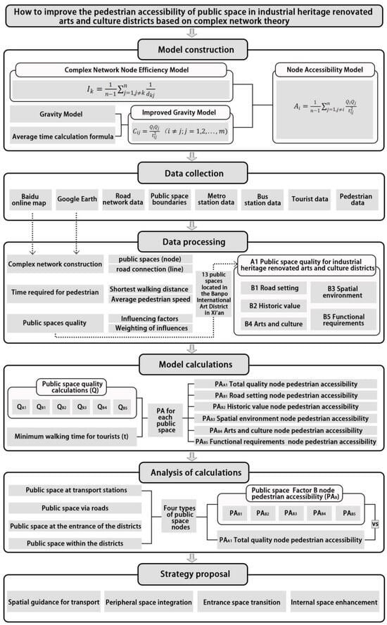
Figure 1.
Methodological framework of this study.
2.2. Method
2.2.1. Node Accessibility of Public Space
In this study, from the perspective of users and their activities, the definition of public space specifically refers to the peripheral and interior open spaces of arts and culture districts that are accessible to tourists. These spaces should be equipped with functions such as rest areas, communication zones, display areas, and leisure and entertainment facilities []. Based on complex network theory, this paper modeled the network of public space of arts and cultural districts renovated with industrial heritage. The center of mass of each public space was selected to form the network node set N, , where i, j, and k represented different nodes, and n was the total number of nodes in the network. In the complex network, nodes are connected by edges. In this study, if two public space nodes were directly reachable from each other without passing through any other nodes, an edge was drawn between them. These edges collectively formed the edge set E,, representing the direct connections between nodes in the network. Thus far, the public spaces were abstracted into a network graph composed of a public space node set N and corresponding edge set E, forming the network G = (N,E) [].
Complex network theory is commonly used to evaluate network nodes with key evaluation metrics including degree centrality, weighted degree centrality, betweenness centrality, neighborhood centrality, and others for quantitative analysis. In this paper, since the study focused on networks related to geographical distance, the node efficiency index was employed to measure the importance of network nodes. Traditional node efficiency index is calculated as the average of the sum of the inverse distances between a given node and all other nodes in the network, as shown in Equation (1):
where Ik represents the network node efficiency of node k; n is the total number of nodes in the network; dkj represents the shortest path from node k to node j. Based on the definition of Ik, node efficiency expresses the average degree of difficulty for a node to reach all other nodes in the network. The higher the efficiency of a node in a network, the easier it is for the node to transmit information to other nodes, consuming fewer resources, and thus indicating the greater importance of the node []. Hence, in the context of the complex network of public spaces within industrial heritage renovated arts and culture districts constructed in this paper, higher node efficiency reflects a more critical role for that node in the network, warranting greater attention in subsequent design improvements.
The original model’s impedance only accounts for the distance, neglecting interactions between spaces. However, people, objects, and information flow between spaces. In the constructed public space network, nodes were interrelated and interacted with each other. The gravity model is a widely used spatial interaction model, functioning as a mathematical equation for analyzing and predicting spatial interaction patterns []. It plays an important role in studying regional spatial interactions and site accessibility. The model is based on Newton’s law of gravitation, which posits that there is an objective interaction between all entities in the universe, and this interaction is referred to as gravity. The gravitational force between two objects depends on their respective mass and the distance between them, exhibiting positive and negative correlations, respectively. This relationship is mathematically expressed in Equation (2):
where Tij represents the amount of interaction between space i and space j; Fi and Fj denote the quality of space i and space j, respectively, often measured using data such as spatial scale, population size, and other relevant factors; dij is the distance between the two spaces; and b is the attenuation parameters. Based on multiple foundational and contemporary studies [,,], the value of b = 2 is widely adopted in distance decay modeling for urban spatial research, as it is recognized to effectively balance the “friction of distance” with the “willingness to overcome it.” The gravity coefficient k is a constant, typically set to 1, and m is the number of spaces [].
As this study focused on the public space accessibility of industrial heritage renovated arts and culture districts, the quality of space is influenced not only by its size, but also by various factors that would have an impact on how difficult it is to reach the space, such as road infrastructure, historical value of the space, spatial environment, etc. Based on this, the concept of total quality of public space Q was introduced. An evaluation system was constructed using the Analytic Hierarchy Process (AHP) combined with the Entropy Weight Method. The total evaluation score of the space was then calculated by considering the values and weights of each factor, which was used as the value for total quality Q.
Based on Equation (2), adjusting the distance dij to the travel time tij, interaction parameter of public spaces can be derived in Equation (3):
where Cij represents the interaction between public space i and public space j; Qi and Qj represent the total quality of spaces i and j, respectively; tij denotes the shortest time required to travel between space i and space j, which is calculated using Equation (4) as follows:
where dij represents the shortest distance between space i and space j, and v denotes the average speed.
Based on above calculation, this study improved the original node efficiency model and integrated it with the gravity model to express the concept of node accessibility, which referred to the average accessibility of a space node i to all other space nodes in the network, reflecting the ease with which a space node can reach another. The core of the two-model integration was to replace the “distance impedance” in Equation (1) with a “gravity interaction” that contained space quality. The node accessibility is calculated using Equation (5) as follows:
where Ai represents the node accessibility of space i in the network; j refers to all other public space nodes except i; n is the total number of nodes in the network; Qi and Qj denote the total quality of space i and space j, respectively; and tij represents the minimum time required to travel between space i and space j.
2.2.2. Quality of Public Space
- (1)
- Quality evaluation index system of public space
In order to make the quality of public space in industrial heritage renovated arts and culture districts more scientific, intuitive and comparable, it is necessary to quantify the affecting factors and construct a corresponding evaluation system, so as to obtain the weight of each factor and quantitatively calculate the quality of each public space. By consulting industry experts, incorporating public opinions, and reviewing the existing literature, this study divided the evaluation index system for public spaces in industrial heritage renovated arts and culture districts into three levels: the first level is target layer A, which defines the quality of public space as the overall goal; the second level is criterion layer B, based on the specific characteristics of these public spaces, including B1 road setting, B2 historical value, B3 spatial environment, B4 arts and culture, and B5 functional requirements; the third level is program layer C, which refines the criteria from each guideline into 23 sub-indicators. The established evaluation index system of public space quality for industrial heritage renovated arts and culture districts is shown in Figure 2.
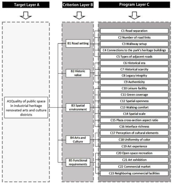
Figure 2.
Public space quality evaluation index system for industrial heritage renovated arts and culture districts.
To test the reliability of this evaluation system, a criticality questionnaire was developed. A total of 35 industry experts were invited to assess the importance of 23 factors across 5 dimensions. The questionnaire employed a five-point Likert scale [], ranging from ‘5’ (very important) to ‘1’ (very unimportant), with intermediate options of ‘4’ (relatively important), ‘3’ (generally important), and ‘2’ (relatively unimportant). The reliability of the scoring results was tested using Cronbach’s alpha []. A Cronbach’s alpha value above 0.8 indicates high reliability []. The collected data were imported into SPSS Statistics 31.0 software for analysis, and the results are displayed in Table 1. The Cronbach’s alpha calue for the questionnaire was 0.814, indicating excellent reliability. Additionally, the average scores for both factors and dimensions were calculated and found to be greater than 3, as shown in Table 2, confirming the importance of each factor. Therefore, the evaluation system can be effectively used to assess the quality of public spaces in industrial heritage renovated arts and culture districts.

Table 1.
Cronbach’s alpha calculation.

Table 2.
Average of expert scores for importance of each factor.
- (2)
- Weighting of impact factors
This study introduced both Analytic Hierarchy Process (AHP) and Entropy Value Method. AHP is commonly used in weight calculation due to its ability to combine quantitative and qualitative characteristics [,]. However, its reliance on expert scoring could introduce subjectivity. To address this, this study incorporated Entropy Value Method, which assessed the importance of different indicators by calculating the entropy value between them and then determining the weight of each indicator []. The arithmetic mean of the results from both methods was taken as a comprehensive weight, combining subjective and objective requirements to enhance the objectivity and accuracy of the results []. Additionally, the score for each factor was obtained through field research, questionnaire and software calculations. Combined with weight calculation, the overall quality of public space in the research site was determined.
In hierarchical analysis process, 12 industry experts were invited to complete a relevant questionnaire, including 3 professors, 4 associate professors, and 5 architects. The questionnaire utilized a 1–9 scale to compare the indicators at the same level pairwise, determining the relative importance of each indicator in relation to a guideline from the previous level. However, the author recognized that expert opinions might be influenced by perceptions of the current state of the site, representing a potential limitation of subjective weighting. Consistency tests were conducted on returned questionnaires, and all passed the validity test. The collected data were then imported into Yaahp V10.3 software for calculation, yielding the weight w1.
Entropy Value Method was applied to scoring data from 35 experts based on previous criticality questionnaire, and the data was imported into SPSS software for calculation, yielding the weight w2. However, the raw data used in the Entropy Value Method was collected in April and May 2024, a period during which the site had already exhibited the unbalanced development described at the beginning of this paper. Consequently, the entropy-weighted results to some extent reflect the existing conditions of that period, representing a potential limitation of the objective weighting approach. Finally, the arithmetic mean of the two weights w1 and w2, was taken as the final weight w. A combination of linear-weighted subjective and objective weights was employed to balance theoretical significance (AHP) with empirical data performance (entropy weight). We tested various weighting ratios (e.g., 0.3:0.7, 0.4:0.6) and found the conclusions to be robust. However, it should be noted that the selection of coefficients itself reflects the researcher’s value judgment, specifically, the relative degree of trust placed in subjective versus objective weights. The calculation results are presented in Table 3.

Table 3.
Weighting of impact factors.
According to the quality evaluation index system, for each public space, total quality of public space QA1 would be evaluated by the weighted sum of five quality values in criterion layer B, namely quality of road setting QB1, quality of historical value QB2, quality of spatial environment QB3, quality of arts and cultural value QB4, and quality of functional requirements QB5, as shown in Equation (6).
QA1 = 0.12QB1 + 0.27QB2 + 0.19QB3 + 0.13QB4 + 0.29QB5
And for each quality value in criterion layer B, it would be evaluated by the weighted sum of corresponding quality values in program layer C, as shown in Equations (7)–(11):
QB1 = 0.15QC1 + 0.16QC2 + 0.27QC3 + 0.17QC4 + 0.25QC5
QB2 = 0.22QC6 + 0.27QC7 + 0.27QC8 + 0.24QC9
QB3 = 0.16QC10 + 0.13QC11 + 0.12QC12 + 0.17QC13 + 0.13QC14 + 0.16QC15 + 0.13QC16
QB4 = 0.32QC17 + 0.2QC18 + 0.48QC19
QB5 = 0.21QC20 + 0.22QC21 + 0.24QC22 + 0.33QC23
2.3. Study Area and Data
2.3.1. Xi’an Banpo International Art District
Xi’an, once an important textile industrial base in northwestern China, has seen many of its industrial production sites fall into disuse due to policy changes and urban transformation. In recent years, Xi’an has issued several documents related to the transformation of industrial heritage. A number of these sites, including West Film Studio, Dahua 1935, and Banpo International Art District, have been revitalized as arts and culture districts, though with varying degrees of success []. This study selected Xi’an’s Banpo International Art District as a case study, as shown in Figure 3.
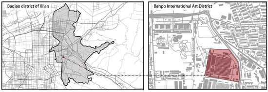
Figure 3.
Location of study area in Xi’an city.
The buildings in Banpo International Art District are predominantly Soviet-style, with the main factory building being a key feature of the district. Characterized by its sawtooth roofs and preserved walls, the surrounding structures, which were formerly used as auxiliary rooms, also hold significant historical value. The district covers a large area, and the diverse architectural layouts have created public spaces in various forms. Inside these spaces, textile instruments and murals with prominent artistic styles remain, showcasing the distinctive industrial culture of Northwest China.
The nearby public transportation options include Banpo Station on Metro Line 1, which experiences a relatively high volume of passengers and is heavily utilized. In recent years, Fangerlu Station on Metro Line 6 has also been newly opened, with various forms of public spaces established around the station to facilitate pedestrian movement and crowd evacuation. In addition, Banpo bus station is located close to the main entrance of the art district, and, to a certain extent, improved accessibility to the site. Based on road connections from public transportation stations to the site, the primary sources of pedestrian flow are concentrated on the east, west, and south sides of the site, as shown in Figure 4. However, public infrastructure in the surrounding area is inadequate, with many buildings being relatively old and few new constructions in progress. Additionally, each public space operates independently and lacks cohesive connections, making it especially important to analyze its construction network.
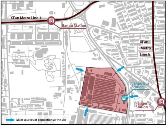
Figure 4.
Public transportation around the site and main sources of pedestrian movement.
2.3.2. Construction of Public Space Network
In determining the scope of the network, we conducted on-site research by surveying 124 visitors who walked from nearby transport stations to the public spaces of Banpo International Art District. The survey revealed that 76% of the visitors arrived via metro. Of these, only 4 people used Metro Line 6, while the remainder traveled on Metro Line 1. Additionally, 24% of the visitors arrived via Banpo bus station. Given the current context, Banpo Station on Metro Line 1 is situated adjacent to railway tracks from the industrial period, providing relatively high historical value. In contrast, Fangerlu Station on Metro Line 6 is located near residential areas and holds less industrial historical significance. Banpo bus station is located at the district entrance, within a public space. Therefore, the public spaces surrounding Banpo Station on Metro Line 1, the public spaces along the path from Banpo Station to Banpo International Art District, and the public spaces within the district itself were selected as the study area and formed the network. Based on research and on-site interviews, the walking routes of tourists from Banpo Station on Metro Line 1 to Banpo International Art District are depicted in Figure 5.
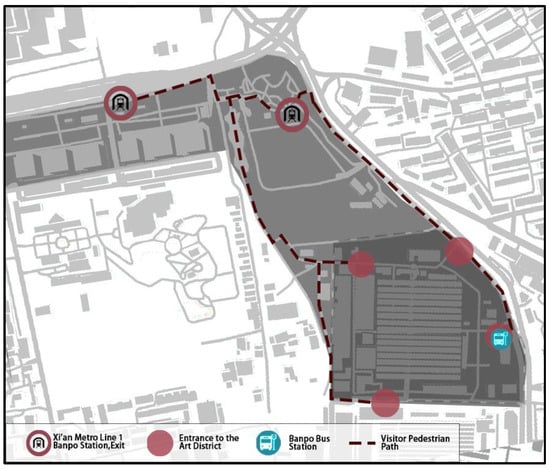
Figure 5.
Walking routes within study area.
According to the definition of public space in the previous section, the selected public space nodes must include multiple functions such as rest, entertainment, gathering, and transportation. Through on-site research, 13 public spaces were selected along these routes, as shown in Figure 6a. The selected public spaces vary in their degree of openness, including both outdoor and semi-outdoor spaces. The boundaries of these public spaces were defined by physical barriers such as fences, walls, gates, or natural features (e.g., rivers, tree lines). In open areas, boundaries were typically defined by pavements, building facades, or specific landmarks. Considering the existing conditions, it can be observed that public spaces No. 2 and No. 4 are designated for transportation near the metro station. Public spaces No. 6, No. 9, No. 11, and No. 13 are internal entrance spaces within the district, with space No. 11 containing the Banpo bus stop. Public spaces No. 1, No. 3, and No. 5 are non-transport spaces located around the district, while public spaces No. 8, No. 10, and No. 12 are situated inside the district.
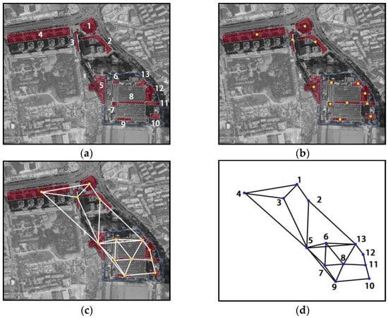
Figure 6.
(a) Thirteen public space locations and outlines; (b) the center of mass for each public space; (c) construction of public space network edges; (d) the network of public spaces in Banpo International Art District.
The center of quality for each public space was selected as node in the network, as shown in Figure 6b. An edge was set up if there was a directly accessible path between two spaces; if the two spaces needed to pass through other public spaces to reach each other, no edge was set up, as shown in Figure 6c. The network of public space in Banpo International Art District was formed, as illustrated in Figure 6d.
2.3.3. Data Collection and Quality Calculation of Public Space
The questionnaire employed a five-point scale, with “very satisfied” corresponding to 100 points and “very dissatisfied” to 20 points. It was distributed to 124 tourists who arrived at Banpo International Art District via public transport during on-site research. The scoring results were then averaged to calculate the arithmetic mean, representing the score for each factor. The assignment of each factor is presented in Figure 7, and the scores obtained for each factor in program layer C are shown in Table 4.
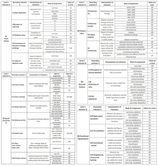
Figure 7.
Criteria for assigning values to factors in program layer C.

Table 4.
Scores of factors in program layer C for each public space.
Based on Equations (6)–(11), and the corresponding scores, a quality score for each public space was produced, as shown in Table 5, and the hot spot maps for each spatial quality are shown in Figure 8.

Table 5.
Quality score of selected public spaces.
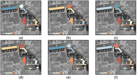
Figure 8.
(a) Total quality hot spot map for 13 public spaces; (b) road setting quality hot spot map for 13 public spaces; (c) historic value quality hot spot map for 13 public spaces; (d) spatial environment quality hot spot map for 13 public spaces; (e) arts and culture quality hot spot map for 13 public spaces; (f) functional requirement quality hot spot map for 13 public spaces.
2.3.4. Walking Time
The shortest path was obtained using Baidu Maps, with the starting and end points positioned at the center of quality for each public space. As the mode of transportation was set as walking, the Baidu Maps automatically planned the shortest suitable route based on physical road network, as shown in Figure 9. Based on field research, the study area features a single-path system with pedestrian and vehicular traffic separated. Intersections exhibit no waiting delays or crossing penalties. In this study, the walking speed of tourists was set to 80 m/min, as referenced in existing studies []. The walking time between any two public spaces was calculated in Equation (4), and the results are presented in Table 6.
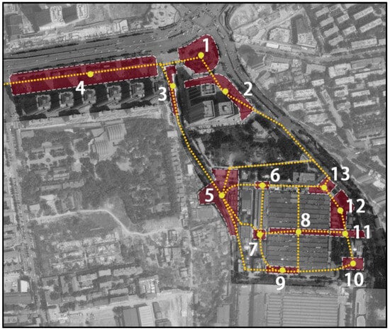
Figure 9.
A route map for the shortest paths between 13 public spaces.

Table 6.
Time taken to walk between two nodes (in units of min).
3. Results
3.1. Node Pedestrian Accessibility
Based on processed data, the pedestrian accessibility of each node in the network of public spaces of Banpo International Art District was calculated according to Equation (5), and the results are presented in Table 7 below.

Table 7.
Public space node pedestrian accessibility of Banpo International Art District.
3.2. Node Pedestrian Accessibility Analysis Based on Functionalized Categorizations
Based on the different functions of selected nodes, this study categorized the nodes of public space network at Banpo International Art District into four categories: public space at the transport stations, public space via roads, public space at the entrance of the district, and public space within the district. Public spaces at the transport stations refer to the spaces where public transport stations are located, corresponding to nodes No. 2, No. 4, and No. 11 in the network, which functionally connect to the city’s public transportation systems. Public spaces via roads refer to nodes that are outside the district and do not serve public transport functions, which include nodes No. 1, No. 3, and No. 5. Public spaces at the entrance of the district are located at the main and secondary entrances within the district and act as linking points between the internal and external site, which are represented by nodes No. 6, No. 9, No. 11, and No. 13. And public spaces within the district refer to internal public spaces, excluding the entrance areas, which include nodes No. 7, No. 8, No. 10, and No. 12.
Given the varying number of nodes with different functions, this paper proposed using the average node pedestrian accessibility of each type of public space as the representative accessibility for that category. The calculation results are presented in Table 8 and illustrated in Figure 10.

Table 8.
Node pedestrian accessibility for four types of public space nodes.
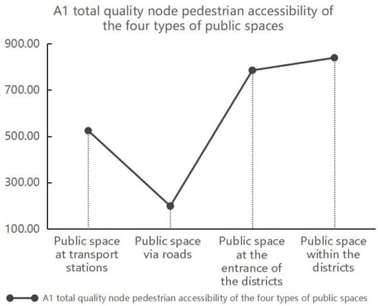
Figure 10.
Pedestrian accessibility of four types of public space nodes. Note: This study is based on an analysis of n = 13 public space nodes, categorized into the four functional types listed above. AA1 Total Quality Node Pedestrian Accessibility: the integrated pedestrian accessibility score, synthesizing all dimensional factors.
As shown in Figure 10, public space within the district shares the highest pedestrian accessibility, indicating that such nodes are most efficient in reaching than other functional nodes and play a more significant role in the existing network. Public space at the entrance of the district is only the second to that of public space within the district, while the other nodes exhibit lower accessibility. The entrances serve as key nodes for visitors navigating the network, highlighting the need to identify and address potential issues to enhance their function. The pedestrian accessibility of public space at transport stations is relatively low, despite their critical role in guiding access to the industrial heritage area, indicating that further improvements are necessary. The pedestrian accessibility of public space via roads is the lowest, reflecting their minimal contribution to the overall network. This is primarily due to the longer walking distance required to reach than other nodes, as indicated by the formula.
3.2.1. Node Pedestrian Accessibility for Public Space at Transport Stations
As shown in Table 8, the total quality of node pedestrian accessibility for public space at transport stations, namely public spaces No. 2, No. 4, and No. 11, is relatively low with a value of 524.41. A comparative analysis of node pedestrian accessibility for public space at transport stations between PAA1 and each PAB reveals that node pedestrian accessibility of road settings (PAB1), historical value (PAB2), and functional requirements (PAB5) are relatively high, all exceeding the total quality of node pedestrian accessibility (PAA1), as shown in Figure 11. It suggests that the existing road network design at these public spaces is well-developed; the historical value of these spaces is significant; and the internal functions generally meet the needs of tourists. However, node pedestrian accessibility of spatial environment, as well as arts and culture remain low.
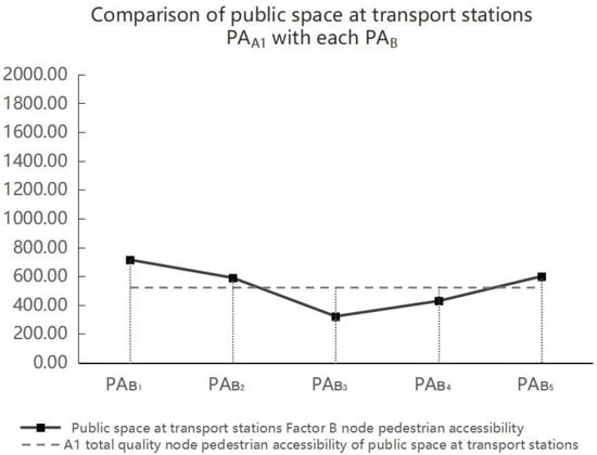
Figure 11.
Node pedestrian accessibility comparison of public space at transport stations between PAA1 and each PAB. Note: This study is based on an analysis of n = 13 public space nodes, categorized into the four functional types: public space at the transport stations, public space via roads, public space at the entrance of the district, and public space within the district. PAA1 Total Quality Node Pedestrian Accessibility: the integrated pedestrian accessibility score, synthesizing all dimensional factors; PAB1 Road Setting Node Pedestrian Accessibility: accessibility influenced by the configuration and connectivity of the surrounding road network; PAB2 Historic Value Node Pedestrian Accessibility: accessibility weighted by the historical significance and heritage value of the space; PAB3 Spatial Environment Node Pedestrian Accessibility: accessibility determined by the quality and design of the immediate spatial environment; PAB4 Arts and Culture Node Pedestrian Accessibility: accessibility enhanced by the presence of arts, cultural features, and programming; PAB5 Functional Requirement Node Pedestrian Accessibility: accessibility driven by the fulfillment of practical needs and functional amenities.
By analyzing the public spaces No. 2, No. 4, and No. 11’s PAA1 value in comparison to each PAB, the lack of cultural and artistic features is a common problem for public space at transport stations, which can be seen in Figure 12, where the arts and culture values (PAB4) are all below the total quality of node pedestrian accessibility values (PAA1). Comparing the PAB4 values for spaces No. 2, No. 4 and No. 11 in Table 7 (70.94, 39.03, and 1176.55, respectively) with the PAB4 value for public space at transport stations in Table 8 (428.84), it can be seen that space No. 11’s arts and culture node pedestrian accessibility is significantly higher than the average for such public spaces, while spaces No. 2 and No. 4 show extremely low arts and culture node pedestrian accessibility, falling at the bottom among all 13 spaces. It is due to the fact that space No. 11 serves not only as a public transportation station but also as an entrance to the art district, with its spatial design placing greater emphasis on cultural and artistic characteristics. In contrast, space No. 2 and No. 4 are merely public transportation stations providing access to the district, located at a certain distance from the art district itself, hence their spatial designs incorporate fewer artistic elements. In subsequent optimization strategies, incorporating cultural and artistic elements into its public space design at public transportation stations farther from the district can enhance the spatial experience and improve its pedestrian accessibility.
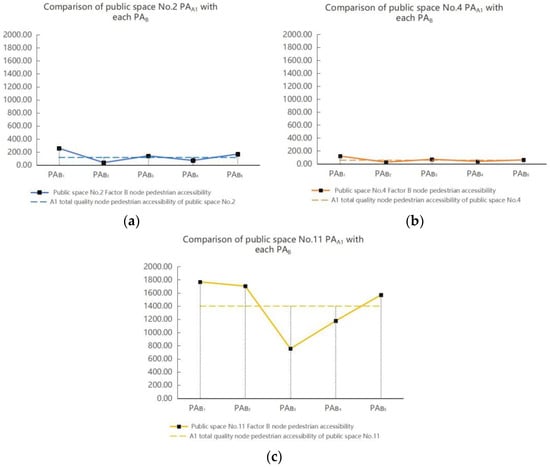
Figure 12.
(a) Node pedestrian accessibility comparison of public space No. 2 between PAA1 and each PAB; (b) node pedestrian accessibility comparison of public space No. 4 between PAA1 and each PAB; (c) node pedestrian accessibility comparison of public space No. 11 between PAA1 and each PAB. Note: This study is based on an analysis of n = 13 public space nodes, categorized into the four functional types: public space at the transport stations, public space via roads, public space at the entrance of the district, and public space within the district. PAA1 Total Quality Node Pedestrian Accessibility: the integrated pedestrian accessibility score, synthesizing all dimensional factors; PAB1 Road Setting Node Pedestrian Accessibility: accessibility influenced by the configuration and connectivity of the surrounding road network; PAB2 Historic Value Node Pedestrian Accessibility: accessibility weighted by the historical significance and heritage value of the space; PAB3 Spatial Environment Node Pedestrian Accessibility: accessibility determined by the quality and design of the immediate spatial environment; PAB4 Arts and Culture Node Pedestrian Accessibility: accessibility enhanced by the presence of arts, cultural features, and programming; PAB5 Functional Requirement Node Pedestrian Accessibility: accessibility driven by the fulfillment of practical needs and functional amenities.
As for spatial environment node pedestrian accessibility, PAB3 value of space No. 11 is much lower than its PAA1, as shown in Figure 12c. However, by comparing the PAB3 values for space No. 2, No. 4, and No. 11 in Table 7 (141.59, 71.51, and 753.78, respectively) with the PAB3 value for public spaces at transportation stations in Table 8 (322.29), the spatial environment node pedestrian accessibility for space No. 11 does not perform poorly among that values of all other spaces, and is even the highest; then, this result can only indicate that the total pedestrian accessibility of public space No. 11 is high, and that the spatial environment here is not as attractive to the population visitors as the other aspects of this space. Conversely, although the PAB3 values for space No. 2 and No. 4 are higher than or approximately equal to their respective PAA1 values, as shown in Figure 12a,b, this does not indicate favorable spatial environmental quality in these spaces, but, rather, their overall low accessibility. Therefore, in subsequent optimization designs, the spatial environment of the public space at public transportation stations should be comprehensively enhanced to improve their pedestrian accessibility. For instance, introducing public leisure facilities for visitors in communal areas, increasing greenery coverage, providing appropriate tree planting along roadways to create shade, removing redundant barriers to open up spaces, and so on.
Meanwhile, the PAB2 values of public space No. 2 and No. 4 are also lower than their respective PAA1 values, indicating that these two spaces are not presenting the historical value of industrial heritage well, as shown in Figure 12a,b; however, public space No. 11 exhibits better historical value relative to other public space at transport stations. Comparing the PAB2 values for spaces No. 2, No. 4, and No. 11 in Table 7 (37.73, 26.9, and 1704.74, respectively) with the PAB2 value for public space at transportation stations in Table 8 (589.79) reveals that the historical value node pedestrian accessibility of space No. 11 is significantly higher than the average for such public spaces, while the historical value node pedestrian accessibility of space No. 2 and No. 4 are extremely low, ranking as the lowest among the 13 spaces. This is because spaces No. 2 and No. 4 are located farther from the industrial heritage district, with virtually no visible industrial historical sites present whereas space No. 11 is adjacent to the district, where industrial remains can be clearly observed.
3.2.2. Node Pedestrian Accessibility for Public Space via Roads
As shown in Figure 10 and Table 8, the total quality of node pedestrian accessibility for public space via roads, namely public space No. 1, No. 3, and No. 5, is the lowest with a value of 199.06. A comparative analysis of node pedestrian accessibility for public space via roads between PAA1 and each PAB indicates that these public spaces obtain better road infrastructures (PAB1) and sufficient functional settings (PAB5), as shown in Figure 13. However, the node pedestrian accessibility of historical value (PAB2), spatial environment (PAB3), and arts and culture (PAB4) remain low, suggesting that the design of these public spaces has less connection to industrial history and arts or culture, and that the spatial environment is underdeveloped.
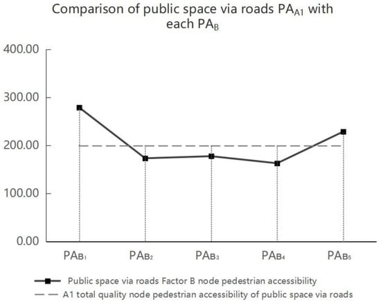
Figure 13.
Node pedestrian accessibility comparison of public space via roads between PAA1 and each PAB. Note: This study is based on an analysis of n = 13 public space nodes, categorized into the four functional types: public space at the transport stations, public space via roads, public space at the entrance of the district, and public space within the district. PAA1 Total Quality Node Pedestrian Accessibility: the integrated pedestrian accessibility score, synthesizing all dimensional factors; PAB1 Road Setting Node Pedestrian Accessibility: accessibility influenced by the configuration and connectivity of the surrounding road network; PAB2 Historic Value Node Pedestrian Accessibility: accessibility weighted by the historical significance and heritage value of the space; PAB3 Spatial Environment Node Pedestrian Accessibility: accessibility determined by the quality and design of the immediate spatial environment; PAB4 Arts and Culture Node Pedestrian Accessibility: accessibility enhanced by the presence of arts, cultural features, and programming; PAB5 Functional Requirement Node Pedestrian Accessibility: accessibility driven by the fulfillment of practical needs and functional amenities.
As shown in Figure 14 and indicated in Table 7, public space No. 5 shows higher values for all PAB among the three public spaces. Combined with the current situational analysis, it can be seen that public space No. 5 is closer to other nodes in the network, with short travel time and strong accessibility. By analyzing the public space No. 1, No. 3, and No. 5’s PAA1 value in comparison to each PAB, a lack of artistic and cultural elements is a common issue for all three public spaces, as shown in Figure 14, where the arts and culture values (PAB4) are all below the total quality of node pedestrian accessibility values (PAA1). Comparing the PAB4 values of public spaces No. 1, No. 2, and No. 5 in Table 7 (90.42, 144.34, and 254.17, respectively) with the PAB4 value of public spaces via roads in Table 8 (162.98), it is evident that the arts and culture node pedestrian accessibility in space No. 1 and No. 3 is below the average for such public spaces, with space No. 1 exhibiting a particularly significant deficiency. Based on the analysis of the current situation, space No. 1 is solely a public urban space with minimal artistic elements incorporated into its design whereas space No. 3, as a locomotive park, though not yet part of the art district, integrates relevant thematic artistic elements into its spatial design.
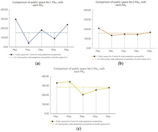
Figure 14.
(a) Node pedestrian accessibility comparison of public space No. 1 between PAA1 and each PAB; (b) node pedestrian accessibility comparison of public space No. 3 between PAA1 and PAB; (c) node pedestrian accessibility comparison of public space No. 5 between PAA1 and each PAB. Note: This study is based on an analysis of n = 13 public space nodes, categorized into the four functional types: public space at the transport stations, public space via roads, public space at the entrance of the district, and public space within the district. PAA1 Total Quality Node Pedestrian Accessibility: the integrated pedestrian accessibility score, synthesizing all dimensional factors; PAB1 Road Setting Node Pedestrian Accessibility: accessibility influenced by the configuration and connectivity of the surrounding road network; PAB2 Historic Value Node Pedestrian Accessibility: accessibility weighted by the historical significance and heritage value of the space; PAB3 Spatial Environment Node Pedestrian Accessibility: accessibility determined by the quality and design of the immediate spatial environment; PAB4 Arts and Culture Node Pedestrian Accessibility: accessibility enhanced by the presence of arts, cultural features, and programming; PAB5 Functional Requirement Node Pedestrian Accessibility: accessibility driven by the fulfillment of practical needs and functional amenities.
In addition, since there is no industrial heritage in public space No. 1, its PAB2 value shows a clear low value. However, public space No. 3 and public space No. 5, which, to varying degrees, have preserved industrial remains such as railroad tracks and structures, show a more noticeable increase in their PAB2 values, as shown in Figure 14b,c, especially public space No. 5, which has been adjacent to the industrial plant, receiving a pretty high historic value score (342.68).
For the spatial environment node pedestrian accessibility, all three public spaces have low PAB3 values, as shown in Table 7. Particularly, as shown in Figure 14c, although public space No. 5 already holds the highest PAB3 value among the three spaces (203.66), it is still a shortfall in its overall pedestrian accessibility. Combined with the previous scores of layer C, as indicated in Table 4, more leisure facilities could be included in public space No. 5, with increased green coverage and appropriate expansion of public area size.
3.2.3. Node Pedestrian Accessibility for Public Space at the Entrance
As shown in Table 8, the total quality of node pedestrian accessibility for public space at the entrance, namely public space No. 6, No. 9, No. 11, and No. 13, is relatively high with a value of 785.08. A comparative analysis of node pedestrian accessibility for public space at the entrance between PAA1 and each PAB reveals that this type of public spaces has higher accessibility in terms of road setting (PAB1) and historic value (PAB2), while the node pedestrian accessibility of spatial environment (PAB3), arts and culture (PAB4), and functional requirements (PAB5) are comparatively lower, as shown in Figure 15. Comparing the PAA1 values of spaces No. 6, No. 9, No. 11, and No. 13 in Table 7 (455.05, 398.74, 1399.7, 886.83, respectively) with the PAA1 value of public space at the entrance in Table 8 (785.08) reveals that the accessibility of space No. 11 and No. 13 exceeds that of space No. 6 and No. 9, aligning with the actual site conditions where space No. 11 and No. 13 serve as the main entrance to the district, space No. 6 functions as a secondary entrance, and space No. 9 operates as a rarely accessible sub-entrance.
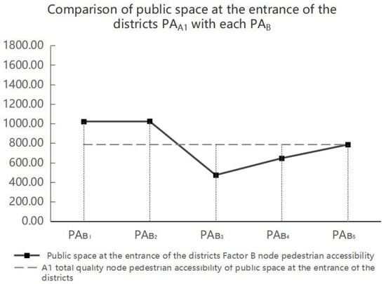
Figure 15.
Node pedestrian accessibility comparison of public space at the entrance between PAA1 and each PAB. Note: This study is based on an analysis of n = 13 public space nodes, categorized into the four functional types: public space at the transport stations, public space via roads, public space at the entrance of the district, and public space within the district. PAA1 Total Quality Node Pedestrian Accessibility: the integrated pedestrian accessibility score, synthesizing all dimensional factors; PAB1 Road Setting Node Pedestrian Accessibility: accessibility influenced by the configuration and connectivity of the surrounding road network; PAB2 Historic Value Node Pedestrian Accessibility: accessibility weighted by the historical significance and heritage value of the space; PAB3 Spatial Environment Node Pedestrian Accessibility: accessibility determined by the quality and design of the immediate spatial environment; PAB4 Arts and Culture Node Pedestrian Accessibility: accessibility enhanced by the presence of arts, cultural features, and programming; PAB5 Functional Requirement Node Pedestrian Accessibility: accessibility driven by the fulfillment of practical needs and functional amenities.
By analyzing the public space No. 6, No. 9, No. 11, and No. 13’s PAA1 value in comparison to each PAB, as depicted in Figure 16, it is found that all PAB values of public space No. 11 are higher than the other nodes, which is in accordance with the current status of public space No. 11 as the most widely recognized main entrance of this district. However, the values for spatial environment node pedestrian accessibility (PAB3) are all below the total quality of node pedestrian accessibility values (PAA1).
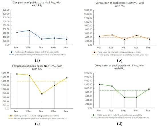
Figure 16.
(a) Node pedestrian accessibility comparison of public space No. 6 between PAA1 and each PAB; (b) node pedestrian accessibility comparison of public space No. 9 between PAA1 and each PAB; (c) node pedestrian accessibility comparison of public space No. 11 between PAA1 and each PAB; (d) node pedestrian accessibility comparison of public space No. 13 between PAA1 and PAB. Note: This study is based on an analysis of n = 13 public space nodes, categorized into the four functional types: public space at the transport stations, public space via roads, public space at the entrance of the district, and public space within the district. PAA1 Total Quality Node Pedestrian Accessibility: the integrated pedestrian accessibility score, synthesizing all dimensional factors; PAB1 Road Setting Node Pedestrian Accessibility: accessibility influenced by the configuration and connectivity of the surrounding road network; PAB2 Historic Value Node Pedestrian Accessibility: accessibility weighted by the historical significance and heritage value of the space; PAB3 Spatial Environment Node Pedestrian Accessibility: accessibility determined by the quality and design of the immediate spatial environment; PAB4 Arts and Culture Node Pedestrian Accessibility: accessibility enhanced by the presence of arts, cultural features, and programming; PAB5 Functional Requirement Node Pedestrian Accessibility: accessibility driven by the fulfillment of practical needs and functional amenities.
Based on on-site research, space No. 6 currently functions as a parking lot with limited versatility; its western-style facade clashes with the industrial heritage surroundings. Consequently, its performance in terms of arts and culture node pedestrian accessibility and functional requirements is also far from satisfactory, as shown in Figure 16a. Space No. 9 exhibits the lowest PAA1 value among spaces of this category. However, as shown in Figure 16b, its accessibility performance in various aspects is relatively balanced, with no particularly pronounced strengths or weaknesses. Based on field research findings, the lack of large-area activity spaces within space No. 9 is the primary reason for its low PAA3 value; moreover, its distance from other nodes results in overall low accessibility. Space No. 11 serves as the most important main entrance to the entire district, while also demonstrating the highest overall accessibility among such public spaces (PAA1 = 1399.7). However, despite its extensive public space area, the lack of recreational facilities and green settings results in low spatial environment node accessibility, as shown in Figure 16c. Space No. 13 also serves as a main entrance to the district, integrating numerous industrial design elements and offering diverse functions such as rest areas, retail, and dining; however, the overall space lacks sufficient greening and shade, and its design employs excessive colors and elements, leading to lower values for both spatial environment node pedestrian accessibility (PAB3) and arts and culture node pedestrian accessibility (PAB4).
3.2.4. Node Pedestrian Accessibility for Public Space Within the District
As shown in Figure 10 and Table 8, the total quality of node pedestrian accessibility for public space within the district, namely public spaces No. 7, No. 8, No. 10, and No. 12, is the highest with a value of 839.24. A comparative analysis of node pedestrian accessibility for public space within the districts between PAA1 with each PAB reveals that, as shown in Figure 17, the historical value node pedestrian accessibility (PAB2) of this type of space is the highest with the value of 1040.25, indicating that the public spaces within the district possess significant historical value, warranting protection and renovation. However, node accessibility related to the spatial environment (PAB3) and arts and culture (PAB4) remains low, suggesting that despite possessing well-preserved industrial heritage, such spaces have failed to effectively convert these elements into cultural and artistic features that could serve as highlights in public space design.
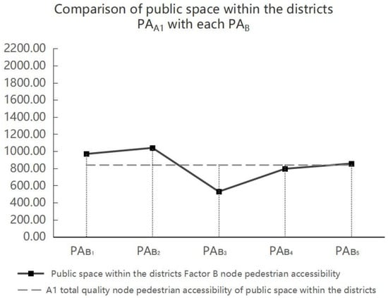
Figure 17.
Node pedestrian accessibility comparison of public space within the districts between PAA1 and each PAB. Note: This study is based on an analysis of n = 13 public space nodes, categorized into the four functional types: public space at the transport stations, public space via roads, public space at the entrance of the district, and public space within the district. PAA1 Total Quality Node Pedestrian Accessibility: the integrated pedestrian accessibility score, synthesizing all dimensional factors; PAB1 Road Setting Node Pedestrian Accessibility: accessibility influenced by the configuration and connectivity of the surrounding road network; PAB2 Historic Value Node Pedestrian Accessibility: accessibility weighted by the historical significance and heritage value of the space; PAB3 Spatial Environment Node Pedestrian Accessibility: accessibility determined by the quality and design of the immediate spatial environment; PAB4 Arts and Culture Node Pedestrian Accessibility: accessibility enhanced by the presence of arts, cultural features, and programming; PAB5 Functional Requirement Node Pedestrian Accessibility: accessibility driven by the fulfillment of practical needs and functional amenities.
By analyzing the public spaces No. 7, No. 8, No. 10, and No. 12’s PAA1 value in comparison to each PAB, poor spatial environment node pedestrain accessibility is a common problem for public space within the districts, as shown in Figure 18, where the spatial environment values (PAB3) are all below the total quality of node pedestrian accessibility values (PAA1). Comparing the PAB3 values for space No. 7, No. 8, No. 10, and No. 12 in Table 7 (396.96, 372.04, 415.35, and 932.02, respectively) with the PAB3 value for public space within the district (529.09) in Table 8 reveals that the spatial environment accessibility of all such spaces except space No. 12 falls below the average for this category of public space. Moreover, regarding space No. 12, spatial environment accessibility is the most deficient among all accessibility aspects. Based on on-site research and analysis, space No. 12 concentrates more functions and activities—such as dining, leisure areas, photo spots, and retail—compared to space No. 7, No. 8, and No. 10, featuring relatively larger areas and richer spatial diversity, attracting more visitors to linger. However, as shown in Figure 18d, the arts and culture node accessibility (PAB4) for space No. 12 is relatively lower compared to other accessibility metrics for that space. Based on the scores for layer C in Table 4, both the color uniformity (C18) and artistic experience (C19) scores for this space are low (36.2 and 47.8, respectively). Based on the findings from the on-site survey, space No. 12 is predominantly occupied by commercial entities, featuring a chaotic style and jarring color schemes. Implementing a unified planning strategy for this space in subsequent optimization efforts—incorporating low-saturation colors that harmonize with the industrial heritage environment while increasing cultural and artistic activities—would significantly enhance its spatial quality and appeal.
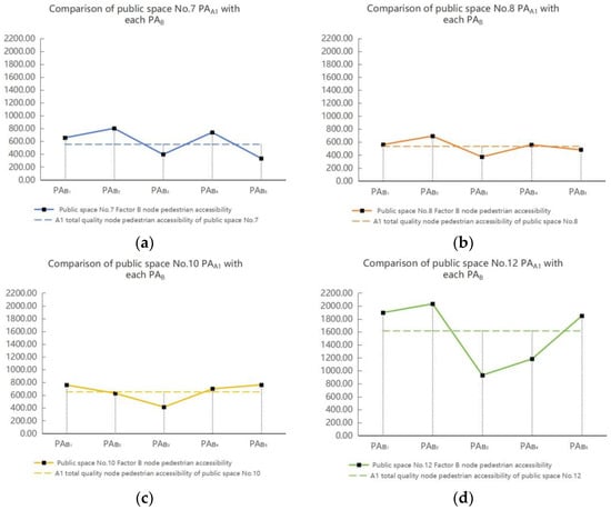
Figure 18.
(a) Node pedestrian accessibility comparison of public space No. 7 between PAA1 and each PAB; (b) node pedestrian accessibility comparison of public space No. 8 between PAA1 and each PAB; (c) node pedestrian accessibility comparison of public space No. 10 between PAA1 and each PAB; (d) node pedestrian accessibility comparison of public space No. 12 between PAA1 and each PAB. Note: This study is based on an analysis of n = 13 public space nodes, categorized into the four functional types: public space at the transport stations, public space via roads, public space at the entrance of the district, and public space within the district. PAA1 Total Quality Node Pedestrian Accessibility: the integrated pedestrian accessibility score, synthesizing all dimensional factors; PAB1 Road Setting Node Pedestrian Accessibility: accessibility influenced by the configuration and connectivity of the surrounding road network; PAB2 Historic Value Node Pedestrian Accessibility: accessibility weighted by the historical significance and heritage value of the space; PAB3 Spatial Environment Node Pedestrian Accessibility: accessibility determined by the quality and design of the immediate spatial environment; PAB4 Arts and Culture Node Pedestrian Accessibility: accessibility enhanced by the presence of arts, cultural features, and programming; PAB5 Functional Requirement Node Pedestrian Accessibility: accessibility driven by the fulfillment of practical needs and functional amenities.
Moreover, as shown in Figure 18a,b, the pedestrian accessibility of nodes within space No. 7 and space No. 8 show similarities, and both exhibit relatively low functional requirement node accessibility. Based on the findings from the on-site survey, it is evident that space No. 7 has a relatively small area and cannot accommodate excessive activities. Meanwhile, the elongated shape of space No. 8 features predominantly private-use functions on both sides, which are not open to the public. Therefore, in subsequent optimization designs, space No. 7 and No. 8 can be integrated to jointly accommodate functions such as art exhibitions and commercial markets, thereby enriching the usage modes of these two spatial nodes.
3.2.5. Quantitative Relationship Verification Between Space Quality and Pedestrian Accessibility
To objectively examine the intrinsic relationship between space quality and pedestrian accessibility, this study employed Pearson correlation analysis to validate the quantitative relationship between the total pedestrian accessibility (PAA1) and its five dimensional components (PAB1–PAB5) of 13 public space nodes, and their corresponding space quality scores (QA1 and QB1–QB5). Based on the data in Table 5 and Table 7, the correlation between space quality and pedestrian accessibility was calculated, with the results presented in Table 9.

Table 9.
Results of Pearson correlation analysis between space quality and pedestrian accessibility.
Correlation analysis confirms that among the five specific quality dimensions examined in this study, four (historical value QB2–PAB2, spatial environment QB3–PAB3, arts and culture QB4–PAB4, functional requirements QB5–PAB5) exhibit statistically significant positive correlations with their corresponding accessibility indicators. This finding not only validates the model’s effectiveness but also reveals the differential impact of various quality factors on pedestrian accessibility, providing crucial evidence for the precise optimization of industrial heritage public spaces.
3.3. Strategies for Pedestrian Accessibility Improving of Public Spaces in Industrial Heritage Renovated Arts and Culture Districts
3.3.1. Industrialization of Transport Public Space
When improving transport public spaces around industrial heritage, the integration of industrial historical elements can enhance the city’s cultural heritage while increasing the recognition and attractiveness of industrial heritage sites through distinctive, space-guided designs. This approach promotes the organic integration of history and modern life. Selecting areas with significant industrial historical value as transport nodes or interchange centers revitalizes the city’s cultural heritage. In the planning phase, public transport spaces could be situated close to industrial heritage art areas, with built transport facilities positioned near these districts to establish additional exits and reduce travel time. In the case of Xi’an Banpo International Art District, it is recommended that the locations of public transportation stops at public spaces No. 2 and No. 4 be slightly shifted along the street where the spaces are situated toward the direction of the industrial heritage site. While placing public transport facilities in areas rich in industrial history allows for a visual display of the city’s industrial development, pedestrians and tourists should also be enabled to naturally encounter this historical information during their daily commutes, as in the case of public space No. 11. By installing industrial heritage exhibition areas, historical timeline walls, or interactive information screens, the transport space transforms from a mere transit point into a vibrant historical education hub. In regions lacking direct industrial heritage, as in the case of public spaces No. 2 and No. 4, an industrial atmosphere can be simulated using colors, materials, and lighting effects reminiscent of the industrial era. For instance, traditional industrial materials such as red bricks, cement, and steel can be employed in spatial construction, alongside imitations of railway tracks, locomotives, and textile machines from the industrial period, creating a time-traveling experience. In the case of Xi’an Banpo International Art District, the corresponding improvement strategies for public spaces at transport stations, specifically public spaces No. 2, No. 4, and No. 11, are shown in Table 10.

Table 10.
Aspects to be improved in public spaces at transport stations and corresponding strategies.
3.3.2. Peripheral Space Integration
The space surrounding an industrial heritage renovation arts and culture district could be designed to integrate industrial elements, activate urban cultural life, and promote community interaction. For instance, the industrial railway tracks adjacent to the art district could be transformed into a railway park, as in the case of public space No. 3, converting what is currently an “industrial rust belt” into an “urban green vein.” This could involve repurposing the original railway lines to create walking or cycling paths. Additionally, small model trains or art installations could be introduced to narrate the story of industrial history in an engaging manner, enhancing the interactivity and educational value of the area. A well-designed wayfinding system, featuring clearly marked signage and artistic road signs, would naturally guide pedestrian traffic between the railway park and the district, fostering a virtuous cycle of interaction between the two spaces. During specific festivals or exhibitions, the railway tracks could serve as a unique exhibition route for themed activities, thereby deepening the public’s understanding of the connection between the art district and industrial heritage. An expanded external space near the entrance of the art district can create a strong visual attraction, stimulating visitors’ curiosity to explore. Moreover, the peripheral wall could become a canvas for industrial esthetics, as in the case of public space No. 5, showcased through murals, installations, or preserved original masonry treated artistically, transforming it into a distinctive urban landscape. This design not only enhances the environment but also allows passersby to experience the rich industrial cultural heritage and artistic atmosphere, even without entering the district. In the case of Xi’an Banpo International Art District, the corresponding improvement strategies for peripheral spaces, specifically public spaces No. 3 and No. 5, are outlined in Table 11.

Table 11.
Aspects to be improved in public spaces via roads and corresponding strategies.
3.3.3. Entrance Space Transition
The entrance plaza, as the initial point of contact, should be designed to be both recognizable and artistically vibrant. Iconic elements such as sculptures (such as public spaces No. 9, No. 11, and No. 13 in the case study), water features, or thematic installations (such as public spaces No. 13) can enhance its appeal. Additionally, an axis extending from the entrance plaza to the core exhibition area can be established to guide visitors seamlessly from the external public space into the interior of the building, as in the case of public space No. 11. This can be achieved through walkways, corridors, or specific visual cues, such as lighting guides and ground markings. Each node along this axis can be designed as a small exhibition area or interactive experience point. For example, touch screens could be installed to provide historical information about the heritage site, or sound devices could recreate the atmosphere of the old workshop, thereby stimulating visitors’ curiosity and encouraging exploration, which can be installed in public spaces No. 11 and No. 13 at the main visitor entrance of the Xi’an Banpo International Art District. The public space at the entrance should also harmonize with the heritage building; this could involve creating an outdoor platform adjacent to the structure or integrating the internal semi-open public space with the entrance area. Such designs would not only serve as guiding features for the building but also enrich the spatial hierarchy of the interface. In the case of Xi’an Banpo International Art District, the corresponding improvement strategies for public spaces at the entrance, namely public spaces No. 9, No. 11, and No. 13, are shown in Table 12.

Table 12.
Aspects to be improved in public spaces at the entrance and corresponding strategies.
3.3.4. Interior Space Enhancement
As walking is the primary mode of transport for tourists in the industrial heritage renovated arts and culture district, renovations should focus on enhancing walking comfort. This can be achieved by increasing green coverage through the addition of street trees, flower beds, and rest areas, which not only beautify the environment but also provide natural shade and improve air quality, thereby creating a pleasant walking atmosphere. In this case, public space No. 10 exhibits low pedestrian accessibility due to insufficient greenery, which can be addressed by increasing vegetation coverage. For public spaces with adequate green coverage, such as public space No. 12 in this example, plant species should be selected to complement the industrial site’s rugged texture and harmonize with the surrounding environment. Additionally, using non-slip, shock-absorbing paving materials such as permeable tiles, wooden walkways, or rubber surfaces can significantly enhance comfort, as applied to the public spaces No. 8 and No. 12 in the case. Furthermore, for public spaces No. 10 and No. 12, which are exposed to prolonged sunlight as in the case, the incorporation of sun-shading structures, such as artistic awnings, pavilions, or vertical green walls, offers shelter from the summer heat while enriching both the functionality and esthetics of public spaces. In planning rest facilities, it is essential to creatively utilize art installations, landscape nodes, and gray spaces at building edges to establish diverse resting areas that cater to visitors’ needs, transforming them into unique landscapes within the arts district and enhancing interactivity and interest, as applied to public spaces No. 8 and No. 12 in this case. Moreover, industrial-style public spaces can serve as platforms for various cultural and artistic activities, including lectures on industrial history, photography exhibitions, and concerts, thereby encouraging community participation and fostering social cohesion. The introduction of interactive art installations, such as sound and light exhibits and inductive sculptures, can create personalized participatory experiences, adding dynamism and vitality to public spaces. In the case of Xi’an Banpo International Art District, the corresponding improvement strategies for public spaces within the district, namely public spaces No. 8, No. 10, and No. 12, are shown in Table 13.

Table 13.
Aspects to be improved in public spaces within the district and corresponding strategies.
3.4. Verification
3.4.1. Robustness Check
To validate the robustness of the constructed pedestrian accessibility model for industrial heritage public spaces, this study re-calculated the accessibility of 13 selected public spaces within the Banpo International Art District using the traditional node efficiency model. The accessibility values Ik from these calculations were then ranked, as shown in Table 14. In this ranking, order 1 represents the highest accessibility, while order 13 indicates the lowest accessibility.

Table 14.
Pedestrian accessibility ranking of 13 selected public spaces in Banpo International Art District calculated using the traditional node efficiency model.
The PAA1 Total Quality Node Pedestrian Accessibility values for the 13 public spaces in Table 7 of this study were ranked, with the results shown in Table 15. In this ranking, order 1 represents the highest accessibility, while order 13 represents the lowest accessibility.

Table 15.
Pedestrian accessibility ranking of 13 selected public spaces in the Banpo International Art District calculated using the industrial heritage public space pedestrian accessibility model.
A comparative analysis of space rankings derived from two space accessibility models reveals that, overall, the rankings of these 13 public spaces exhibit high consistency. Only a few public spaces (such as No. 6, No. 7, No. 8, No. 10, as well as No. 1 and No. 3) show differences in position. However, the relative positions of these spaces within the entire sequence remain largely stable. Further examination of their specific accessibility values reveals that the differences in accessibility scores between public spaces with ranking discrepancies are extremely small, far below the variation levels observed between other spaces. Therefore, it can be concluded that the pedestrian accessibility model for industrial heritage public spaces proposed in this study demonstrates good stability.
In the node efficiency model that considers only distance costs, public spaces No. 1, No. 6, No. 7, and No. 8 show slight improvements due to their non-prominent space quality, while public spaces No. 3 and No. 10 experience declines. This phenomenon clearly demonstrates that the industrial heritage public space pedestrian accessibility model captures accessibility value contributed by the nodes’ intrinsic quality, value overlooked by purely structural analysis methods. This is crucial for evaluating industrial heritage public spaces that emphasize experiential and perceptual dimensions.
3.4.2. Sensitivity Analysis
To assess the robustness of the pedestrian accessibility model for industrial heritage public spaces and quantify the impact of uncertainty in key input parameters, specifically the five dimensional indicators of the B-layer, on output results, this subsection conducted a parameter sensitivity analysis. This analysis aims to identify the parameters most sensitive to model outputs, thereby ensuring the reliability of research conclusions and providing a basis for parameter setting in subsequent model applications.
This study employs a “single-factor analysis method” for sensitivity analysis. Specifically, based on the baseline scenario (with baseline parameter values shown in Table 5), each B-layer dimension is removed while keeping all other parameters constant to isolate the influence of that parameter. The Spearman rank correlation coefficients between the public space accessibility rankings derived from different parameter scenarios and the baseline ranking is shown in Table 16. The analysis reveals that the correlation coefficients for all comparison scenarios exceed 0.7, indicating that the relative ranking structure of public spaces maintains good consistency under different parameter settings. This validates the robustness of the accessibility model proposed in this study.

Table 16.
Spearman’s rank correlation coefficient for B-layer parameters.
4. Discussion
4.1. Public Space in Industrial Heritage Renovated Districts
This study examines public spaces within industrial heritage renovated districts based on complex network theory. By taking pedestrian accessibility as a quantitative indicator, it explores the characteristics and existing challenges of these public spaces and proposes targeted space optimization strategies. The study underscores the pivotal role of public spaces within renovated industrial heritage districts, demonstrating that these spaces serve as vital carriers for diverse social activities and constitute essential components of the district’s spatial fabric. Quantitatively assessing these public spaces will facilitate the revitalization and sustainable development of the entire district.
In research related to industrial heritage renovated districts, studies focusing on public spaces are not lacking. Meng [] took eight industrial heritage conversion and utilization projects in the high-density core area of Beijing’s central city as examples, established an evaluation system for the satisfaction with the spatial reuse through six dimensions, as public space was one of them, and used the IPA method to evaluate the cases. The results of this study revealed that public spaces constituted a vital component of industrial heritage sites and significantly influenced satisfaction with the site’s adaptive reuse. However, this study remains focused on evaluating the industrial heritage district as a whole, without conducting further in-depth exploration or analysis of its public spaces. In contrast, Zhang [] took the “Old market” project as an example, based on spatial production theory, exploring the physical and social transformations of public spaces within industrial heritage revovated districts, revealing patterns of formation, transition, and development. This research not only highlights the significance of public spaces for industrial heritage districts but also transcends mere physical characteristics by incorporating social attributes, offering a comprehensive interpretation of public space []. Zhai employed space syntax theory to conduct an in-depth analysis of public spaces within industrial heritage communities in Taiyuan, China. This research systematically examined the spatial characteristics of such communities, summarized their spatial organization patterns, and concluded that the design of community public spaces effectively promotes collective life and community cohesion. In the meantime, other scholars have interpreted and analyzed the public spaces within industrial heritage districts from perspectives such as place perception [], space narrative [], sharing concepts [], and ecological symbiosis aspect [], proposing strategies for space reuse design based on their findings.
Compared to the aforementioned studies, this research focuses on the public spaces within industrial heritage district, conducting an in-depth examination from the perspectives of historical value, spatial environment, cultural and artistic qualities, and functional design. It encompasses both the physical and social attributes of these spaces, adopting an approach that better aligns with the unique characteristics of industrial heritage sites; at the same time, the study also considers the road settings between different spaces, which establishes connections between them. The selection of public spaces in this study thoroughly considers the connections between the district and surrounding urban facilities and environments. By integrating the public spaces of the industrial heritage district into the city’s public space system and quantifying the spaces from the perspective of pedestrian accessibility for visitors, the research outcomes align more closely with human-oriented space optimization strategies, thereby facilitating the sustainable development and renewal of the industrial district.
4.2. The Interconnectivity Between Spaces
This study provides an in-depth examination of the interconnectivity between spaces when exploring the pedestrian accessibility of public spaces within industrial heritage renovated districts. The research suggests that within an industrial heritage district, the public spaces are both relatively independent and interconnected, with mutual influences existing between them. Therefore, when calculating the pedestrian accessibility of public spaces, the study adopted the node efficiency model from complex network theory as its basic framework, which emphasizes the networking characteristics and systemic properties of public spaces, and improved it with the gravity model—a widely applied space interaction model that employs mathematical equations to analyze and predict space interaction patterns []. This approach highlights the crucial interconnected characteristics between the research subjects.
In existing research on public space accessibility, most scholars still employ Ga2SFCA [,] and space syntax [,,] for computational analysis. Liang employed Ga2SFCA to measure the accessibility of park green spaces at various levels, analyzing their contribution to overall accessibility and further revealing residents’ access patterns to service combinations across different levels of park green spaces; Maimaitizunong focused on the historical district of Shache as the research subject, employing space syntax theory and methodology, and conducted a quantitative deconstruction analysis of the public spaces within the historical district using two analytical dimensions: integration and comprehensibility. The study identified existing issues and proposed recommendations for optimization and improvement; Li addressed the issue of poor utilization of public spaces in coastal villages by conducting a case study of Gangdong Village in Qingdao, employing a combined approach of field research and space syntax analysis. The findings revealed that enclosure, accessibility, and visibility are key factors influencing the utilization of public spaces.
Thus, it is evident that Ga2SFCA and space syntax are the preferred research methods for scholars analyzing space accessibility. However, while space syntax can characterize the connectivity of an entire space network to a certain extent, this method only reflects space structure and establishes topological connections between two spaces, failing to account for the influence of factors such as function, environment, history, and culture on space accessibility. Moreover, Ga2SFCA measures space accessibility based on supply–demand relationships and social equity perspectives, and does not incorporate the crucial characteristic of interconnectivity between spaces. It is noteworthy that this study combines the node efficiency model with an improved gravity model to propose the node accessibility model. It incorporates space quality—which encompasses various non-topological attributes of public spaces—as a key indicator within the gravity model. This approach examines the impact of interconnectivity between spaces on their accessibility from both topological and intrinsic perspectives.
4.3. The Relationship Between Accessibility and Space Quality
This study concludes that the pedestrian accessibility of public space is positively correlated with the quality of the spaces. Moreover, the quality of public spaces depends on multidimensional evaluation criteria, encompassing not only physical attributes such as road settings—that is, the topological connections between spaces—but also other intrinsic qualities including historical value, spatial environment, the expression of arts and culture, and functional requirements. Indicators across various dimensions contribute to the quality of public spaces with differing weights, while also exerting varying impacts on the accessibility of these spaces. Among these, notably, the appropriate road setting between the public spaces contributes to positive pedestrian accessibility, while poor spatial environment and lack of arts and cultural atmosphere are the key reasons for the low pedestrian accessibility of the public spaces in the district.
In studies examining the accessibility of public spaces, most scholars have focused merely on the topological relationships between spaces [,,,,] and the time and distance required to reach one space from another [,,]. For example, Jin [] used Suzhou’s central urban area as a case study, employing Ga2SFCA to analyze differences in accessibility among various types of green spaces. The computational factors included population data for green space usage and travel data—specifically, the time and distance required for residents in different neighborhoods to reach green spaces. Che [] analyzed the accessibility of green spaces in the central urban area of Yantai City, under various transportation modes using network analysis and space syntax. Based on accessibility from the user’s perspective, the study comprehensively evaluated the actual accessibility of these green spaces, with factors primarily derived from space structure relationships. Such studies, grounded in the fundamental theory of accessibility, consider only the costs involved in the process of travel while neglecting the attributes of the destination space itself.
This study improves the original node efficiency model by maintaining the travel impedance inherent in traditional accessibility calculations—represented here as tourist walking time—while simultaneously introducing space quality as a measure of target space attractiveness and incorporating multidimensional evaluation indicators within this space quality framework. The resulting approach to space accessibility better aligns with space-specific characteristics and proves more suitable for accessibility research in related disciplines such as architecture and urban planning.
4.4. Limitations and Future Research Directions
The current study presents several limitations that should be addressed in the future research. First, the methodological approach inherits certain inherent constraints. Data collection relied on questionnaires and on-site surveys, which, despite passing reliability tests, are susceptible to sample bias and the inherent subjectivity of expert scoring within the AHP–Entropy weight model. Furthermore, key parameters in the accessibility model, such as the distance decay coefficient in the gravity model and the average walking speed, were assigned fixed values based on the existing literature. While this standardization ensures the model’s function as a comparative tool, it also means the results are sensitive to these predefined parameters and may not fully capture the nuanced mobility patterns of specific populations. Second, the generalizability and contextual accuracy of the findings require further validation. The spatial quality indicators were developed for a specific case study in a particular socio-cultural context. Consequently, they may not fully capture the unique attributes and complexities of industrial heritage sites in other regions with different social backgrounds and cultural characteristics. Third, the study employs a static and simplified representation of pedestrian movement. The model is based on the shortest path distance, which is a physical optimization. In reality, pedestrian route choice is influenced by a multitude of factors, including scenery, safety, and points of interest, creating a potential discrepancy between the modeled and actual paths. The static nature of the one-off data collection also means the model may not promptly reflect dynamic changes in site conditions over time.
Based on the above limitations, future research may continue in the following areas:
Integrating multi-source data for enhanced objectivity and dynamism. Consider using big data technologies such as mobile signaling data, GPS trajectory data, and social media geolocation data to conduct objective, large-scale dynamic monitoring of population spatiotemporal behavior, effectively addressing the limitations of questionnaire sample size and subjective bias. In addition, future research should explore establishing a “dynamic monitoring-evaluation-feedback” framework. This framework enables routine monitoring of pedestrian density and movement patterns by deploying multi-source sensors (e.g., Wi-Fi/Bluetooth beacons, turnstile counters) at key locations within the Banpo site, combined with periodic GPS trajectory sampling and time-stratified manual counts. These dynamic data streams feed into a cloud computing platform that continuously calibrates and updates the pedestrian accessibility model developed by this institute, revealing underlying patterns in how accessibility evolves across seasons, time periods, and specific events (e.g., art exhibitions, cultural festivals, markets). Ultimately, the system delivers data-driven real-time feedback and scientific basis for site-specific operations, including crowd flow management during festivals and introducing new business formats during off-peak seasons, alongside adaptive optimizations such as facility layout adjustments.
Refining the model through behavioral observation and parameter calibration. Future research may adopt the following behavioral observation approach for triangulation: At the Banpo site, conduct short-duration (e.g., 1 h per period) pedestrian traffic counts during three typical time periods, morning, noon, and evening, on both weekdays and weekends. Focus on four key zones—the main entrance, central plaza, primary scenery area, and industrial heritage exhibition zone. Simultaneously, a small sample of volunteers (e.g., n = 20) could be recruited to wear portable GPS loggers, capturing precise movement trajectories during actual space usage. These data will be directly applied to calibrate the Tij matrix based on network distance in this study, significantly enhancing the model’s accuracy in depicting real-world mobility patterns.
Developing a generalized yet adaptable evaluation framework. To enhance the cross-regional applicability of the research, future efforts should focus on establishing a more generalized and adaptable evaluation indicator system. This can be achieved through cross-regional, cross-cultural comparative case studies to identify core common factors and context-specific factors influencing pedestrian accessibility. The evaluation system can be designed to incorporate modular indicators that reflect local activity patterns, social structures, and cultural preferences, allowing it to be tailored to accurately capture space utilization needs across diverse socio-culturalcontexts.
5. Conclusions
This paper applied complex network theory to examine pedestrian accessibility in industrial heritage renovated public space, integrating an existing node efficiency model with an improved gravity model to propose the node accessibility model. Initially, the AHP–entropy method was employed to construct an evaluation system that determined the weights of each factor affecting public space quality. These weights were supplemented by scores derived from field research and questionnaires, leading to a combined final result. In addition, the shortest path and average speed were used to ascertain time metrics. And Banpo International Art District in Xi’an was selected as a typical case study, where 13 node public spaces were categorized into four types: public space at transport stations, public space via roads, public space at the district entrance, and public space within the district, and individually analyzed.
The results are as follows:
- (1)
- Overall, public space pedestrian accessibility shows a positive correlation with the quality of the spaces, though individual nodes may deviate due to network effects such as walking time and connections to other nodes. In Banpo International Art District, public spaces via roads have the lowest total quality node pedestrian accessibility, while public spaces within the district share the highest, supporting this trend.
- (2)
- The appropriate road setting between the public spaces in Banpo International Art District contributes to positive pedestrian accessibility in this area, which is reflected in an effective road connectivity between the spaces, the paving of sidewalks, and the connection between the public spaces and industrial heritages. However, poor spatial environment and lack of arts and cultural atmosphere are the key reasons for the low pedestrian accessibility of the public spaces in this district. In the subsequent optimization, public spatial environment can be reinforced, such as setting up leisure facilities, adding green coverage, improving walking comfort and enriching space layouts, etc., and incorporating more elements that can manifest the cultural and artistic characteristics of the industrial heritage, so as to promote the tourists’ artistic experience.
- (3)
- According to the node pedestrian accessibility model and the analysis of Banpo International Art District case, the strategies for improving the pedestrian accessibility of public spaces in industrial heritage renovated arts and culture districts were summarized, which included industrialization of public transport space, peripheral space integration, entrance space transition and internal space enhancement.
This study conducted a quantitative analysis of public spaces in industrial heritage renovated arts and culture districts from the perspective of tourists’ pedestrian accessibility, provided scientific methodology and theoretical guidance for the optimization of public space in industrial heritage renovated project, and contributed new insights into industrial heritage preservation and urban space renewal.
Author Contributions
Conceptualization: X.X. and E.D.; data collection: X.X., J.Y. and E.D.; data analysis: X.X. and E.D.; results, interpretation, and visualization: X.X., J.Y., E.D. and L.B.; manuscript preparation: X.X., J.Y. and E.D.; supervision: W.L. and K.Y.; project administration: X.X.; funding acquisition: X.X., W.L. and K.Y. All authors have read and agreed to the published version of the manuscript.
Funding
This research was supported by the National Natural Science Foundation of China (Grant No. 52278047); 2025 Shaanxi Province Fundamental Research Program in Natural Sciences (Grant No. 2025JC-YBQN-555); 2022 Shaanxi Province Philosophy and Social Science Research Specialization (Grant No. 2022HZ1661); and the Fundamental Research Funds for the Central Universities, CHD (Grant No. 300102414103).
Data Availability Statement
The datasets generated and/or analyzed during the current study are available from the corresponding author on reasonable request. The data are not publicly available due to privacy restrictions.
Conflicts of Interest
The authors declare no conflicts of interest.
References
- Chen, X.; Xing, K.; Du, C.; Wang, Y.T.; Chen, H. Implicit Narratives: Theoretical Construction of Design Expression in the Regeneration of Industrial Heritage Landscapes. Chin. Landsc. Archit. 2024, 40, 62–67. [Google Scholar]
- Zhou, B.; Meng, Y.; Li, X.; Liu, S. Study on the Spatial Differentiation and Influencing Factors of Settlement Cultural Heritage in the Grand Canal Cultural Belt (Jiangsu-Zhejiang Section). Resour. Environ. Yangtze Basin 2024, 33, 1942–1952. [Google Scholar]
- Sun, M.; Chen, C. Renovation of industrial heritage sites and sustainable urban regeneration in post-industrial Shanghai. J. Urban Aff. 2021, 45, 729–752. [Google Scholar] [CrossRef]
- Han, H. Cultural Pathways and Implementation Mechanisms of Industrial Heritage Reuse in Serving the Process of New Industrialization. Dongyue Trib. 2024, 45, 50–55. [Google Scholar]
- Ren, X. Building Globalization: Transnational Architecture Production in Urban China; University of Chicago Press: Chicago, IL, USA, 2015. [Google Scholar]
- Xu, A.; Ma, H.; She, Y. Research on the Renovation and Transformation Strategies for Urban Old Industrial Areas—A Case Study of the West Bund in Shanghai. J. Intell. Build. Smart Cities 2021, 12, 54–55. [Google Scholar]
- Zheng, J.; Chan, R. The impact of ‘creative industry clusters’ on cultural and creative industry development in Shanghai. City Cult. Soc. 2014, 5, 9–22. [Google Scholar] [CrossRef]
- Wu, C.; Shao, X.; Shen, Q. Distribution Patterns and Influencing Factors of Online Attention to Industrial Tourism in China. Areal Res. Dev. 2023, 42, 72–78. [Google Scholar]
- Jin, A.; Ge, Y.; Zhang, S. Spatial Characteristics of Multidimensional Urban Vitality and Its Impact Mechanisms by the Built Environment. Land 2024, 13, 991. [Google Scholar] [CrossRef]
- Jonas, V.; Katrin, A.L.; Otsuka, N.; Welsch, J. Determinants and effects of perceived walkability: A literature review, conceptual model and research agenda. Transp. Rev. 2023, 43, 303–324. [Google Scholar]
- Rosa, M.P.; Tavares, I.L.; Loureiro, N.S. Cultural accessible pedestrian ways. The case of Faro historic centre. J. Tour. Herit. Res. 2020, 3, 75–95. [Google Scholar]
- Jiménez, M.D.; Ramírez, S.A.; Ajuriaguerra, E.M.A. Urban Accessibility in World Heritage Cities. Accessibility Considerations in Pedestrian Routes in Historic City Centres. Transforming Our World Through Universal Design for Human Development; IOS Press: Amsterdam, The Netherlands, 2022; pp. 499–506. [Google Scholar]
- Pretto, A. A study on accessibility in an Old Italian City: When the past is worth more than the present. Disabil. Soc. 2022, 37, 496–521. [Google Scholar] [CrossRef]
- Zhu, Y. Shared Waterfront: A Chronicle of Industrial Heritage Along the Suzhou River; Tongji University Press: Shanghai, China, 2022. [Google Scholar]
- Bazazzadeh, H.; Nadolny, A.; Attarian, K.; Safar Ali Najar, B.; Hashemi Safaei, S.S. Promoting sustainable development of cultural assets by improving users’ perception through space configuration; case study: The industrial heritage site. Sustainability 2020, 12, 5109. [Google Scholar] [CrossRef]
- Song, Z.; Wang, L. Research on the Protection and Reuse of Chongqing’s Modern Industrial Heritage. Shanghai Urban Plan. 2022, 5, 131–137. [Google Scholar]
- Chakraborty, S.; Ji, S. A review of integrating space syntax analysis into heritage impact assessment: A comprehensive framework for sustainable historic urban development. Int. J. Urban Sci. 2025, 29, 123–150. [Google Scholar] [CrossRef]
- Jiang, Z.; Qi, Z.; Chen, L.; Xu, L.; Wan, D.; Burak-Gajewski, P.; Zawisza, R.; Liu, L. External spatial morphology of creative industries parks in the industrial heritage category based on spatial syntax: Taking Tianjin as an example. Buildings 2024, 14, 559. [Google Scholar] [CrossRef]
- Yang, Z.; Wang, R.; Gong, X. Comprehensive Assessment of Spatial Regeneration of Industrial Architectural Heritage Based on Spatial Syntax Approach: A Study in Qingdao, China. In Conference on High-Quality Urban Development and Beautiful Countryside Construction; Springer: Singapore, 2024; pp. 525–547. [Google Scholar]
- Jian, L.; Xia, X.; Zhao, Y.; Yang, Z.; Yuanqiao, W.; Yi, T.; Jie, C.; Changliu, W. Evaluating the Accessibility of Urban Public Open Spaces Based on an Improved 2SFCA Model: A Case Study Within Chengdu’s Second Ring Road. Land 2025, 14, 188. [Google Scholar] [CrossRef]
- Jiang, Z. Exploring the spatial dynamics of cultural facilities based on multi-source data: A case study of Nanjing’s art institutions. Open Geosci. 2023, 15, 20220532. [Google Scholar] [CrossRef]
- Chen, Z.; Liu, Q.; Li, M.; Xu, D. A New Strategy for Planning Urban Park Green Spaces by Considering Their Spatial Accessibility and Distributional Equity. Forests 2024, 15, 570. [Google Scholar] [CrossRef]
- Song, J.; Chen, J.; Yang, X.; Zhu, Y. Research on Adaptive Reuse Strategy of Industrial Heritage Based on the Method of Social Network. Land 2024, 13, 383. [Google Scholar] [CrossRef]
- Li, A.; Wahid, W.A. Conservation situation and social network analysis of industrial heritage in Tangshan City, China. Int. J. Art Des. 2023, 7, 16–27. [Google Scholar] [CrossRef]
- Serrano-Estrada, L.; Martí, P.; Bernabeu-Bautista, Á.; Huskinson, M. Mapping heritage engagement in historic centres through social media insights and accessibility analysis. Land 2024, 13, 1972. [Google Scholar] [CrossRef]
- Li, L.; Peng, K.; Han, J.; Shen, H.; Li, X. Research on Methods for the Conservation and Renewal of Industrial Heritage from the Perspective of Value Inheritance. Ind. Archit. 2023, 53, 67–74. [Google Scholar]
- Li, Q.; Peng, S.; Du, H.; Wang, J.; Zhang, J. Research on the Public Space Design Strategy of Industrial Heritage-Type Cultural and Creative Parks Based on the Concept of Symbiosis—A Case Study of Shougang High Line Park. J. Beijing Univ. Civ. Eng. Archit. 2024, 40, 28–36. [Google Scholar]
- Zheng, X.; Chen, T.; Zheng, C.; Heath, T. Unlocking Public Engagement in Reused Industrial Heritage: Weighting Point Evaluation Method for Cultural Expression. Buildings 2024, 14, 2695. [Google Scholar] [CrossRef]
- Pu, H.; Li, Y.; Ma, C. Topology analysis of Lanzhou public transport network based on double-layer complex network theory. Phys. A Stat. Mech. Its Appl. 2022, 592, 126694. [Google Scholar] [CrossRef]
- Wei, M.; Xu, J. Assessing road network resilience in disaster areas from a complex network perspective: A real-life case study from China. Int. J. Disaster Risk Reduct. 2024, 100, 104167. [Google Scholar] [CrossRef]
- Kumar, J.S.; Archana, B.; Muralidharan, K.; Kumar, V.S. Graph Theory: Modelling and Analyzing Complex System. Metall. Mater. Eng. 2025, 31, 70–77. [Google Scholar] [CrossRef]
- Su, S.; Liu, J.; Wang, Y.; Dong, K. Research on Topological Characteristics of Spatial Network Based on Complex Network Theory and Its Applications. Mathematics 2024, 12, 3746. [Google Scholar] [CrossRef]
- Liu, J.B.; Zheng, Y.Q.; Lee, C.C. Statistical analysis of the regional air quality index of Yangtze River Delta based on complex network theory. Appl. Energy 2024, 357, 122529. [Google Scholar] [CrossRef]
- Hansen, W.G. How Accessibility Shapes Land Use. J. Am. Inst. Plan. 1959, 25, 73–76. [Google Scholar] [CrossRef]
- Zhang, Y. Identification of Commercial Spaces and Service Areas in Wuhan’s Main Urban Area Based on Network Data. Master’s Thesis, Wuhan University, Wuhan, China, 2018. [Google Scholar]
- Hong, X.; Li, S.; Chen, T.; Ji, X.; Song, X. Spatial performance evaluation and optimization of integrated aboveground and underground spaces in urban commercial complexes. J. Asian Archit. Build. Eng. 2025, 24, 623–649. [Google Scholar] [CrossRef]
- Samavati, S.; Desmet, P.M.A.; Ranjbar, E. Happy urban public spaces: A systematic review of the key factors affecting citizen happiness in public environments. Cities Health 2025, 9, 112–128. [Google Scholar] [CrossRef]
- Zhu, J. Public space and its publicness in people-oriented urban regeneration: A case study of Shanghai. J. Urban Aff. 2025, 47, 2319–2338. [Google Scholar] [CrossRef]
- Qi, J.; Mazumdar, S.; Vasconcelos, A.C. Understanding the relationship between urban public space and social cohesion: A systematic review. Int. J. Community Well-Being 2024, 7, 155–212. [Google Scholar] [CrossRef]
- Ma, Y.; Su, N.; Tu, T. Urban public space quality evaluation methods and practices in China. Trans. Urban Data Sci. Technol. 2023, 2, 59–80. [Google Scholar] [CrossRef]
- Szczepańska, A.; Pietrzyk, K. An evaluation of public spaces with the use of direct and remote methods. Land 2020, 9, 419. [Google Scholar] [CrossRef]
- National Development and Reform Commission. Implementation Plan for Promoting the Protection and Utilization of Industrial Heritage in Old Industrial Cities; Revitalization and Development No. [2020] 839; National Development and Reform Commission: Beijing, China, 2020. [Google Scholar]
- Ministry of Industry and Information Technology of the People’s Republic of China. Implementation Plan for Advancing Industrial Cultural Development (2021–2025); Ministry of Industry and Information Technology of the People’s Republic of China: Beijing, China, 2021. [Google Scholar]
- Ministry of Industry and Information Technology of the People’s Republic of China. Provisional Rules for the Administration of National Industrial Heritage; Ministry of Industry and Information Technology of the People’s Republic of China: Beijing, China, 2023. [Google Scholar]
- Agryzkov, T.; Martí, P.; Nolasco-Cirugeda, A.; Serrano-Estrada, L.; Tortosa, L.; Vicent, J.F. Analyzing Successful Public Spaces in an Urban Street Network Using Data from the Social Networks Foursquare and Twitter. Appl. Netw. Sci. 2016, 1, 12. [Google Scholar] [CrossRef]
- Cui, X.; Lu, Q.; Li, J. Identification of Key Stations in Urban Rail Transit Based on Network Redundancy. China Saf. Sci. J. 2022, 32, 158–164. [Google Scholar]
- Wang, L.; Lin, Z.; Pan, J.; Yang, K.; Zou, W. Assessing the Robustness of Geographic Grid Networks Using Node Efficiency. J. Hubei Univ. Sci. Technol. 2013, 33, 139–141. [Google Scholar]
- Song, C.; Zhang, K.; Huo, J. Construction and Application of a Regional Passenger Transport Model Based on Urban Gravity. Urban Transp. 2019, 17, 99–104. [Google Scholar]
- Zhao, Y.; Zhang, G.; Zhao, H. Spatial network structures of urban agglomeration based on the improved Gravity Model: A case study in China’s two urban agglomerations. Complexity 2021, 2021, 6651444. [Google Scholar] [CrossRef]
- Zheng, Y.Y.; Shida, Y.; Takayasu, H.; Takayasu, M. Enhancing the gravity model for commuters: Time-and-spatial-structure-based improvements in Japan’s metropolitan areas. PLoS ONE 2025, 20, e0329603. [Google Scholar] [CrossRef] [PubMed]
- Kong, F.; Yin, H.; Nakagoshi, N.; Zong, Y. Urban green space network development for biodiversity conservation: Identification based on graph theory and gravity modeling. Landsc. Urban Plan. 2010, 95, 16–27. [Google Scholar] [CrossRef]
- Wu, H.; Li, L. Study on the Developmental Differences of High-Speed Rail Station Areas in China: Analysis Based on the Gravity Model. Price Theor. Pract. 2018, 9, 159–162. [Google Scholar]
- Li, S.; Wang, H.; Chen, G. Research on Strategies to Enhance the Vitality of Industrial Heritage Based on Post-Occupancy Evaluation—A Case Study of Taigucang in Guangzhou. Decoration 2023, 8, 130–132. [Google Scholar]
- Zhao, W. Research on Evaluation Indicator System of Green Institutional Retirement Buildings. Master’s Thesis, Guilin University of Technology, Guilin, China, 2022. [Google Scholar]
- Navarrete, J.U. Validation of a Satisfaction Survey using Cronbach’s Alpha and Aiken’s V: Improving Data Quality. Prim. Sci. Eng. 2023, 3, 29–31. [Google Scholar]
- Chen, C.; Gong, Y.; Wang, L.; Wang, H.W. Exploring Renewal Models for Inefficient Land Use of Industrial Heritage under the Context of Heritage Conservation—A Case Study of the Dongmao Warehouse District in Shenyang. Shanghai Urban Plan 2023, 5, 119–125. [Google Scholar]
- Duan, C.; Li, L. Constructing a Cultural Corridor-Based Path for the Integrated Protection and Utilization of the Qin Straight Road—A Case Study of the Yan’an Section. J. Arid Land Resour. Environ. 2022, 36, 192–199. [Google Scholar]
- Guo, Y. Comprehensive Evaluation of Urban Flood Resilience Based on AHP-Entropy Method. Urban Archit. 2023, 20, 157–161. [Google Scholar]
- Huang, Z. Research on the Suitability of Public Service Facilities for Epidemic Prevention and Control Based on AHP-Entropy Method. Master’s Thesis, Hunan University, Hunan, China, 2022. [Google Scholar]
- Han, S.H.; Zhang, H. Progress and Prospects in Industrial Heritage Reconstruction and Reuse Research during the Past Five Years: Review and Outlook. Land 2022, 11, 2119. [Google Scholar] [CrossRef]
- Yang, Y.; Qian, Y.; Zeng, J.; Wei, X.; Yang, M. Walkability measurement of 15-minute community life circle in Shanghai. Land 2023, 12, 153. [Google Scholar] [CrossRef]
- Meng, F.; Zhang, X.; Pang, Y. Evaluation of satisfaction with spatial reuse of industrial heritage in high-density urban areas: A case study of the core area of Beijing’s central city. Buildings 2024, 14, 1473. [Google Scholar] [CrossRef]
- Zhang, X.; Ren, Y. Revitalization of urban industrial heritage from a perspective of spatial production theory: The case study of “Old market” project. J. Asian Archit. Build. Eng. 2024, 24, 3440–3456. [Google Scholar] [CrossRef]
- Zhai, Y.K.; Kang, F.; Zhang, Z.B. Analysis of Public Spaces in Unit-Based Communities within Industrial Heritage Sites Based on Spatial Syntax: The Case of Taiyuan Industrial Heritage from the First Five-Year Plan. Chin. Overseas Archit. 2025, 6, 25–28. [Google Scholar]
- Zhang, Q.Z.; Wu, F.W. A Study on Regeneration Strategies for Public Spaces in Beijing’s Industrial Heritage Sites from a Place-Perception Perspective: The Cases of Shougang Park and 798 Art District. Beijing Plan. Rev. 2025, 4, 91–96. [Google Scholar]
- Huo, S.G.; Tian, G.Y.; Zhang, J.D. Multilayered Narratives in Urban Space Design: An Analysis of Narrative Design in Shanghai’s “Huangpu Riverside Public Space”. Art Work 2024, 1, 123–125. [Google Scholar]
- Liu, X.Y.; Wang, L.C.; Bai, C.Q. Strategy for Community Renewal of Industrial Heritage under Sharing Orientation—Taking the Public Space of Luoyang Pneumatic Tool Plant as an Example. Hous. Sci. 2025, 45, 23–30. [Google Scholar]
- Li, Q.; Peng, S.M.; Du, H.; Wang, J.; Zhang, J. Research on Public Space Design Strategy of Industrial Heritage Cultural and Creative Park Under the Concept of Symbiosis: Taking Shougang High Line Park as an Example. J. Beijing Univ. Civ. Eng. Archit. 2024, 40, 28–36. [Google Scholar]
- Zhang, Y.T.; Sun, J.G.; Du, L.Z.; Zhou, L. Analyzing spatial accessibility to secondary education resources in Liupanshan area. Sci. Surv. Mapp. 2019, 44, 52–58+87. [Google Scholar]
- Liang, Y.R.; Liu, Z.Q.; Hong, G.W.; Yu, H. A study on the measurement of spatial accessibility of park green space based on graded perspective: A case study of city center in Suzhou. J. Suzhou Univ. Sci. Technol. (Eng. Technol. Ed.) 2025, 38, 62–70. [Google Scholar]
- Shi, F.A. Study on the Accessibility of Public Spaces in Urban Districts Based on the 2SFCA Method. Hous. Real Estate 2025, 9, 62–64. [Google Scholar]
- Maimaitizunong, K.; Zulihuma, A.; Aishanjiang, A. Research on the Accessibility of the Public Space in Historic Neighborhoods Based on Spatial Syntax: A Case of Shache Historic District. Urban. Archit. 2025, 22, 16–19. [Google Scholar]
- Yang, W.T.; Liao, D.N.; Liu, D.H. Outdoor Space Accessibility of University Campus Based on Space Syntax: A Case Study of Hubei Normal University. Huazhong Archit. 2024, 42, 56–60. [Google Scholar]
- Li, C.; Cao, Z. Research on the optimization of public space in coastal villages based on space syntax and villager evaluation: A case study of Gangdong Village, Qingdao. J. Qingdao Univ. Technol. 2024, 45, 60–68. [Google Scholar]
- Jin, Y.F.; Liu, Z.Q.; Hong, G.W.; Yu, H. Spatial Accessibility of Park Green Space in Suzhou City Center Based on Nested Perspective. J. Chin. Urban For. 2025, 23, 130–137. [Google Scholar]
- Che, Y.X.; Li, C. Accessibility analysis of park green spaces based on network analysis and spatial syntax: Taking the central urban area of Yantai as an example. J. Shandong Jianzhu Univ. 2025, 40, 92–98. [Google Scholar]
Disclaimer/Publisher’s Note: The statements, opinions and data contained in all publications are solely those of the individual author(s) and contributor(s) and not of MDPI and/or the editor(s). MDPI and/or the editor(s) disclaim responsibility for any injury to people or property resulting from any ideas, methods, instructions or products referred to in the content. |
© 2025 by the authors. Licensee MDPI, Basel, Switzerland. This article is an open access article distributed under the terms and conditions of the Creative Commons Attribution (CC BY) license (https://creativecommons.org/licenses/by/4.0/).