Abstract
In the era of stock-oriented development, cultural diversity encourages the sustainable revitalization of old urban areas, which have accumulated rich cultural resources, reflecting complex human–environment relationships. To transform these resources and relationships into planning information, this empirical study of open spaces in the old city of Nanjing, China, designs a cultural map based on the relationship between culture and urban residents, using cultural categories, cultural value scores and land-use types as coordinates for cultural sites. It evaluates the current state and effective use of cultural resources to reveal their presence and operation in old urban open spaces. The current state of cultural resources was evaluated by key indicators—cultural density, cultural resource aggregation patterns, and matching degree between cultural maps and related planning. The results show that the spatial structure derived from cultural density analysis, the aggregation patterns obtained through kernel density analysis, and the matching degree between the cultural mapping and relevant plans provide a reference for adjustments to the development plans in Nanjing’s old city, demonstrating the potential of cultural mapping as a tool for planning and research. The proposed methodology can be applied and evaluated in broader contexts.
1. Introduction
Changes in economic, social, and institutional systems have fundamentally altered the driving forces and mechanisms of urban development, influencing the evolution of the urban space and transforming and developing urban culture [1]. As essential carriers and incubators of urban culture, open spaces in old cities often contain traditional or distinctive cultural elements through architecture, landscape, and activities, holding historical memories and cultural values accumulated over time [2,3]. The international community has consistently placed high importance on the protection and continuity of urban culture. Both the United Nations Educational, Scientific and Cultural Organization Recommendation on the Historic Urban Landscape (2011) and New Urban Agenda (2016) explicitly emphasize preserving urban historical heritage and cultural diversity as a core concern in cultural heritage management and as a pivotal driver for urban sustainable development [4,5]. However, modernization is often overemphasized when developing open spaces in old cities, thus failing to protect and utilize cultural resources [6,7] and contributing to cultural homogenization [8]. Traditional cultural recognition and value assessment rely on textual expressions. These approaches can provide some systematization and theoretical interpretation of culture. However, cultural information scattered across texts, if not applied to specific spaces, lacks a holistic understanding and evaluation. Consequently, these cultural resources are unlikely to be effectively incorporated into urban planning or related development plans. Therefore, we explore how to recognize the materialized outcomes of various cultures in old cities’ open spaces. Evaluation data is presented in a schematic form, revealing the relationship between culture and space and its significance in the development of old cities.
“Urban cultural mapping” provides people with a medium to retrieve textual and graphic materials related to the city’s historical and cultural sites and events. Researchers can use this specialized mapping to explore the city’s historical depth, grasp its cultural characteristics [9], and present cultural resources systematically and visually using intuitive cartographic language. This reflects the distribution, types, and features of resources in different regions. Additionally, cultural mapping can reveal the intrinsic connections and spatial relationships among cultural resources, offering intuitive and comprehensive information support to decision-makers, researchers, and the public. Thus, this study aims to develop a cartographic and evaluative methodology for cultural mapping of old urban open spaces, building upon existing concepts to address the following questions: (1) How can cultural maps reveal the real relationship between culture and community? (2) How can the status and spatial structural characteristics of cultural resources in old urban open spaces be characterized? (3) How can cultural mapping be applied to support sustainable urban planning?
This paper is organized as follows: Section 2 reviews relevant literature, tracing the evolution of the “mapping” concept, assessing the state of current research, and establishing the necessity of this study. Section 3 introduces the study area and methodology, including basic information on Nanjing’s old city, cultural category classification, cultural map construction, and evaluation methods. Section 4 presents data analysis, quantifying evaluations across three dimensions: cultural density, cultural resource aggregation patterns, and the alignment between the cultural map and related plans, followed by conclusions. Finally, the discussion and conclusions are presented.
2. Literature Review
2.1. Theoretical Foundation: Conceptualizing the Evaluation Framework
Conventional studies of culture and heritage have often relied on dualistic frameworks—such as indigenous or historical [10], tangible or intangible [11,12], and official or unofficial—emphasizing grand narratives while overlooking the everyday relationships between people and cultural sites. Recent scholarship, in contrast, increasingly emphasizes human agency, recognizing that the cultural value of urban space emanates from social practices and affective engagement within cultural settings [13]. Urban culture is produced, perceived, and sustained by people; thus, the relationship between culture and communities constitutes a foundational lens for understanding urban cultural significance. This relationship is embodied through continuous bodily practice and daily life, through which people appropriate, interpret, and assign meaning to urban spaces [14]. Culture manifests through three essential attributes: it is (1) produced through practice, emerging not as a preformed entity but through ongoing social interactions, rituals, and commemorations; (2) a medium of memory, materialized in heritage artifacts and sustained through intangible customs and narratives, linking past and present while reinforcing collective identity; and (3) an instrument of identity, enabling individuals and communities to cultivate belonging and sense of place through cultural participation.
Henri Lefebvre’s theory of the production of space [15], which illuminates space as socially constructed—a site not only of physical form but also of social reproduction and transformation—provides a critical foundation for this study. This perspective redirects the research focus from isolated material entities such as buildings and structures to analyzing the dynamic interactions between entities and open spaces, as well as the community cultural practices and values embodied through these dynamics [14,16]. Building on this theoretical foundation, we introduce the operational concept of “cultural site” to articulate the constitutive association between entities and spaces, thus establishing a theoretical framework for exploring the interconnection between culture and community. Cultural value assessment thus aims to operationalize the communal meaning and vitality of a location, translating abstract values into comparable metrics. International efforts such as the UNESCO Culture|2030 Indicators [17] offer frameworks for evaluating culture’s role in sustainable development. Earlier methodological contributions, such as the nine-rectangle-grid framework proposed by Huang et al. [1] identify nine key assessment indicators—including location, generation age, scale, significance of figures and events, uniqueness, cultural and artistic level, visibility, integrity, and facility level—to interpret the richness and depth of urban cultural entities. Recent research reflects a turn toward multidimensional and systematic appraisal, incorporating criteria such as authenticity and integrity [18,19], cultural diversity and revitalization [7,20], and environmental and spatial characteristics [21]. This evolving consensus confirms that cultural valuation must extend beyond material preservation to include perceptual, functional, and emotional dimensions, thereby more fully capturing the contemporary relevance and vitality of cultural heritage.
2.2. Cultural Mapping: Conceptual Origins and Evolving Applications
The concept of “mapping” originates from cartography. This branch of geography focuses on the objective measurement and representation of the Earth’s surface. Mapping has expanded from merely depicting geographic information to a creative practice encompassing cultural symbols and the spiritual realm [22]. Denis Cosgrove emphasized its role as an active instrument for social cognition in his work Mappings [23]. He argued that “mapping” not only reproduces geographic information but also uncovers deeper social, cultural, and political phenomena through observation and analysis of the surrounding environment. Its interpretive and constructive abilities play a crucial role in planning and design. Despite varying interpretations of “mapping” across disciplines, it aims to enhance understanding and reflect on social realities through map-making.
Cultural mapping takes the concept of “mapping” as its theoretical foundation. It originated from the Chicago School’s application of map methods in the study of social space. Later, influenced by the “cultural turn” of geography, some researchers paid attention to the cartographic presentation of daily cultural practice [24]. In 2006, UNESCO issued its first official document on cultural mapping—the Havana Bulletin—as a practical and participatory planning and development tool that can “transform the intangible and invisible into a medium that can be applied to heritage management, education, and intercultural dialogue” [25]. Scholars have defined cultural mapping as “an activity providing new methods for describing, explaining, and dealing with the cultural resources of communities and places” [26]. This not only illustrates the distribution and development status of specific material cultural elements but also renders the stories, practices, relationships, memories, and rituals shaping local identities visible [27,28]. Cultural mapping has become widespread internationally, spanning fields such as tourism geography, arts and culture, and urban planning. In tourism geography, cultural mapping has transcended the limitations of traditional cartography to identify and evaluate the value of cultural resources to tourist destinations. Research has explored the relationship between cultural heritage and marine environments [29,30], ecosystem services [31] and cultural heritage in tourism hotspots [32]. These perspectives aim to expand tourism resources by integrating natural and cultural assets, enhancing the tourism appeal of cultural heritage [33]. In arts and culture, cultural mapping is a crucial medium for exploring and expressing a community’s cultural identity and historical memory. For instance, Mukwidigwi et al. examined how monuments’ spatial characteristics contribute to reconstructing memory and identity [34], particularly within urban public spaces. Other scholars have reignited enthusiasm for historic neighbourhoods by narrating stories associated with landmark buildings or constructing collective memories [35,36]. Additionally, scholars have incorporated artistic and civic engagement to investigate a city’s sense of place [37] and cultural resources.
In summary, cultural mapping has been widely applied across multiple disciplines using both “top-down” and “bottom-up” research methodologies. However, existing studies have often emphasized qualitative analysis. The application of cultural mapping in quantitative analysis and its interdisciplinary integration must be strengthened. Within urban planning, cultural mapping is a participatory tool to foster public engagement and community planning [38,39], specifically in placemaking [40], creative production in urban spaces [41], distribution of urban cultural spaces [42], and cultural policy formulation [43,44], and quantification of information to create cultural indicators [45]. This visual tool enables citizens and planners to showcase local narratives and assess the impact of urban planning on cultural heritage [46], facilitating the effective integration of cultural resources with community needs in urban development strategies. This study aligns with current trends, focusing on the cultural information contained in old urban open spaces, it comprehensively considers the practicality of planning implementation and the feasibility of public involvement in utilizing cultural resources by overcoming the limitations of existing research, which has been generalized or focused on communities, historic districts, or cultural heritage. By focusing on the interplay between culture and communities, this study constructs a cultural map of old urban open spaces to represent the cultural accumulation and preservation status of these spaces visually and systematically. It also portrays the city’s intrinsic historical development and spatial evolution [47], potentially opening new research avenues and applications for cultural mapping.
3. Materials
3.1. Study Area
This study examines the open spaces of Nanjing’s old city, covering an area of approximately 44 km2, which encompasses the core urban sectors of Xuanwu, Qinhuai, and Gulou districts. The area is characterized by high population density, intensely concentrated socio-economic activities, and a significant agglomeration of public cultural facilities (Figure 1). By constructing a cultural map, it systematically assesses the cultural significance of these spaces, demonstrating the value of cultural mapping in the old city’s future development. Nanjing, one of China’s first national historical and cultural cities, has a rich history spanning over 7000 years. It has a city-building history of around 2600 years and served as the capital for nearly 500 years during a pivotal period in modern Chinese history. Nanjing also pioneered urban planning in 1919. The 1929 Capital Plan– the earliest and most comprehensive systematic planning document in modern urban planning for Nanjing—sought to transform the city into “a model city for the nation, comparable to Europe’s and America’s great cities”. This plan laid the foundation for the structure of Nanjing’s old city [48]. William C. Kirby, a professor at Harvard University, praised the historical significance of the Capital Plan. He noted that its advanced planning standards rivaled those of the world’s leading metropolitan cities at the time. The plan emphasized developing open spaces and preserving historical and cultural heritage [49]. Subsequently, the Outline of the Urban Plan for Nanjing introduced the concept of cultural heritage preservation, emphasizing the protection of historical relics and architecture to preserve cultural achievements within open spaces [50]. Therefore, the open spaces of Nanjing’s old city are highly representative subjects of cultural research.
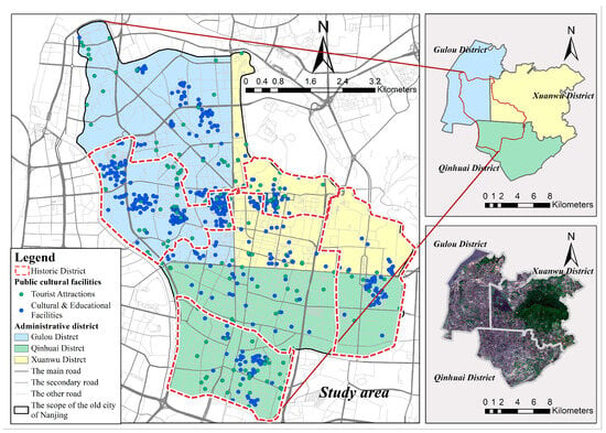
Figure 1.
Overview map of Nanjing’s old city.
3.2. Data Acquisition
We derived the basic cultural map from the satellite map of Nanjing on the BIGEMAP GIS Office (v25.5.0.1). It was imported it into ArcGIS 10.8 for data processing, obtaining the spatial coordinates of 59 cultural sites. These were then matched and calibrated. The road network of Nanjing’s old city was obtained from the Nanjing Vector Road Network on the BIGEMAP GIS Office. We imported it into ArcGIS 10.8 and superimposed it with the old city’s base map after manual data processing, obtaining a complete base map for analyzing cultural information in Nanjing’s old city.
Land-use and historical cultural information was primarily determined from three sources: government planning documents, literary sources (Further details are provided in Supplementary Table S1) and field investigations (Figure 2). The field investigations had two purposes: data collection for mapping; and comparing government planning documents with the investigation results to document the differences. Fifty-nine cultural sites in Nanjing’s old city and its surrounding areas met the inclusion criteria. Selected sites such as Xuanwu Lake, Zhongshan Mausoleum, Wuding-men Park, and Yueya Lake Park are accessible and situated near the old city’s boundary.
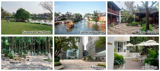
Figure 2.
Field photographs of representative cultural sites in Nanjing’s old city.
4. Methodology
This study employed a hybrid methodology integrating cultural mapping and quantitative evaluation to holistically assess cultural resources within Nanjing’s old urban open spaces (Figure 3). First, we classified the culture of the old urban open spaces as relic, living, or other culture. This provided the foundation for the study. Then, we constructed the cultural map using cultural categories, cultural value scores, and land-use types as coordinates for cultural sites. Utilizing the information from the cultural map, we quantitatively evaluated the current state of cultural resources in Nanjing’s old urban open spaces considering three aspects: cultural density, cultural resource aggregation patterns, and matching degree between cultural maps and related planning. The goal was to reveal the cultural patterns of old urban open spaces and provide a scientific basis for the protection and planning of urban culture. While creating the cultural map and evaluating the current cultural resources, we followed two fundamental principles. First, we examined the relationship between culture and community. Second, we examined the relationship between culture and the old city’s spatial structure.
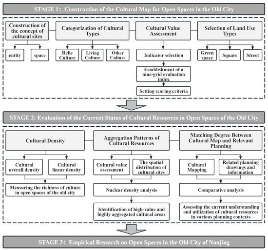
Figure 3.
Flow chart.
4.1. Methodology for Constructing the Cultural Map of Old Urban Open Spaces
4.1.1. Cultural Sites
To observe the relationship between culture and community, we build a concept of cultural site based on open spaces, including both entities and spaces. Entities refer to buildings, structures, and other objects in an open space. Space refers to the open space itself. Two situations can lead to an open space being a cultural site. The first is the existence of cultural entities in an open space; the second is when the entity serves as the boundary of the open space, forming a vertical interface with no separation between the entity and open space. This enables open spaces to comprise all cultural sites in a city. Importantly, open spaces are accessible to community residents. This creates the necessary conditions for community residents to sustain and create culture through bodily practices.
4.1.2. Cultural Categories
The first step in constructing a cultural map is categorizing the culture under investigation. The culture of old urban open spaces is created through long-term social, economic, cultural, and environmental accumulation. It encompasses a wealth of cultural information and activities. Considering the relationship between culture and people, the culture of old urban open spaces can be divided into three categories. The first category is relic culture, which refers to cultural achievements created by predecessors, such as various historical landscapes or open spaces of historical value within old urban open spaces. The second category is living culture, which refers to culture still in development, including both material and immaterial culture. It expresses the vitality of open spaces and reflects community residents’ daily lives. The third category, which we refer to as “other culture”, is related to local cultural psychology or traditions as well as cultures that have not fully formed. The latter spontaneously emerge in open spaces used by community residents in various ways. Living culture and other culture are defined based on the relationship between culture and the community, regarding community residents as both the subjects of cultural practice and evaluation.
4.1.3. Cultural Value Score
The cultural value-scoring criteria for cultural sites are based on the research findings in reference [1]. We examine the sites from three aspects: material elements, perceptual elements, and cultural connotations. We selected 12 evaluation indexes, including generation age, scale, importance of people and events, uniqueness, cultural and artistic level, visibility, integrity, openness, facility level, authenticity, health, and popularity (Table 1).

Table 1.
Evaluation index system of open spaces.
We designed the nine-rectangle-grid evaluation index of open space culture according to the characteristics of different types of culture. Both heritage (Figure 4a) and living (Figure 4b) cultural sites were assessed using the following indicators: generation age, scale, uniqueness, integrity, openness, and facility level. In addition, heritage sites were assessed using the importance of people and events, cultural and artistic level, and visibility. The assessment of living cultural sites also included authenticity, health, and popularity. Other cultural sites were evaluated based on five indicators: integrity, openness, facility level, generation age and scale. Every indicator is evaluated on a 5-point scale (Table 2). Popularity is determined by on-site questionnaires. The questionnaire procedure received formal academic review approval, and verbal informed consent was obtained from all participants. The cultural evaluation score for each site was calculated as the arithmetic mean of all indicator scores, based on the premise that all indicators contribute equally to cultural value. To ensure consistency and minimize subjectivity, ten researchers independently performed scoring following a back-to-back procedure, followed by cross-checking and collaborative resolution of discrepancies.
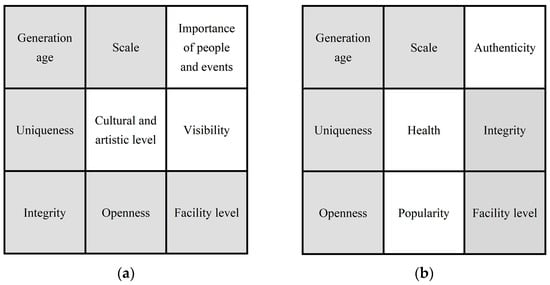
Figure 4.
(a) Assessment indicators of heritage cultural sites; (b) assessment indicators of living cultural sites.

Table 2.
Scale of scores for indicators of cultural sites.
4.1.4. Land-Use Types
Among China’s urban construction land, park green spaces, squares, and streets are the three most open and accessible urban spaces, closely intertwined with citizens’ daily lives and easily quantifiable. Hence, they constitute the primary sample types for this study. Park green spaces, as defined by the Urban Green Space Classification Standard (CJJ/T85-2017) [51] in China, represent a substantial category of green spaces within designated construction areas, essentially functioning as urban parks. Squares fall into two categories: (1) square green spaces, as outlined in the Urban Green Space Classification Standard (CJJ/T85-2002) [52] and (2) small squares formed by the setback of public buildings along streets, which, after landscaping and beautification, serve basic recreational and seating functions. Streets refer to commercial pedestrian streets, historical districts, old streets, and open residential communities that are not enclosed.
4.2. Evaluation of the Current State of Cultural Resources
4.2.1. Cultural Density
Density indicators for urban cultural sites measure the cultural richness of old urban open spaces, including density of overall (1) and linear (2) distributions. Overall density indicates the overall cultural richness of urban open space, while linear density measures the cultural richness of major roads or tourist routes. A higher density value indicates a greater concentration of cultural resources per unit area or unit length. The goal is to observe the spatial structure of cultural sites from the spatial relationship between cultural sites and the community.
Overall Cultural Density = Number of Cultural Sites/Area of Evaluation Including Cultural Sites
Linear Cultural Density = Number of Cultural Sites/Length of a Spatial Route
4.2.2. Cultural Resource Aggregation Patterns
Kernel density analysis (3) can visually reflect the degree of aggregation and distribution patterns of cultural sites by incorporating weights. The kernel function smooths the data points for a more continuous output, revealing the continuity characteristics of cultural resource distribution [53,54]. The analysis was conducted in the ArcGIS 10.8 software. To reflect the aggregation patterns of cultural resources more comprehensively in old urban open spaces, this analysis incorporated value scores. Using the spatial coordinates of the 59 cultural sites as input points and their value scores as the population field, kernel density analysis was applied to generate cultural resource aggregation patterns by category. The search radius used the software’s default value based on Silverman’s rule of thumb [55], which automatically calculates the optimal bandwidth from the input data distribution. The output cell size was set to 10 for high-resolution results. A 9-level equal interval color classification was used to visualize the patterns, with darker colors indicating higher concentration and value of cultural resources, revealing the spatial distribution patterns of cultural value and their impact on the urban cultural landscape.
is the kernel density value at the estimation point, represents the input points; is the bandwidth, in other words, the smoothing parameter ( > 0); is the distance from the estimation point to the cultural sample point. is the cultural value score of each cultural site.
4.2.3. Matching Degree Between Cultural Maps and Plans
The study compared the completed cultural map with the current plans for the sample areas [56]. We considered land spatial planning; historical preservation, tourism, and cultural and creative industry plans, including master plans; planning structures; layouts; and key development areas. This comparison aimed to assess how well the existing plans recognize and utilize cultural resources. The cultural map is not an absolute basis for these plans. However, if these plans capture the regularities displayed in the cultural map, they grasp the true relationship between culture and people in the study’s old urban open spaces. Assuming that the cultural map is accurate and effective, the alignment between the cultural map and relevant plans reflects the degree of utilization and the prospects for cultural resources in the old city.
5. Data Analyses and Results
5.1. Constructing the Cultural Mapping of Nanjing’s Old City
The open spaces with cultural resources in the old city were classified as relic, living, and other cultures. They were marked on the base map, resulting in the cultural map of open spaces in Nanjing’s old city (Figure 5). According to Figure 6, 18 cultural sites are distributed in Xuanwu District, 22 in Qinhuai District, and 19 in Gulou District. One site spans two districts and was classified according to the district in which most of its area lies. 52 samples with relic or living culture were collected, including 16 samples in Xuanwu District, 21 in Qinhuai District, and 15 in Gulou District. 36 sites are relic culture sites, such as the Nanjing Presidential Palace, Jiming Temple, and Zhanyuan Garden. There are 16 living cultural sites, including Xinjiekou, Confucius Temple, and East Zhonghua Gate Historical Culture Block. 7 are considered other culture sites, such as Yuejiang Tower, Daxing Palace Square, and Yueya Lake Park. Among these 59 cultural sites, 33 are park green spaces, 11 are squares, and 15 are streets.
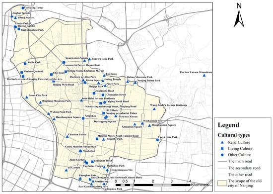
Figure 5.
Cultural types of open spaces in Nanjing’s old city.
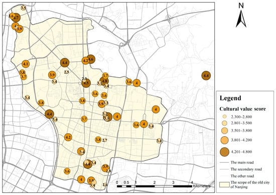
Figure 6.
Cultural evaluation scores of open spaces in Nanjing’s old city.
We evaluated the cultural value information and indicators for the 59 selected cultural sites. Figure 4 summarizes the cultural evaluation factors for relic and living culture open spaces. For other types of open spaces, where culture is not yet fully developed, the evaluation is based on five indicators: integrity, openness, facility level, generation age, and scale. The nine-rectangle-grid score of each cultural site was averaged to obtain a cultural evaluation score (Figure 6).
Based on these results, the “cultural information sheet” formed by the cultural types, cultural value scores, land-use types (Figure 7) and spatial locations are placed on the base map, resulting in the cultural map of open spaces in Nanjing’s old city (Figure 8).
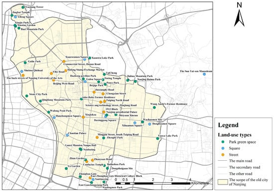
Figure 7.
Land use types of open spaces in Nanjing’s old city.
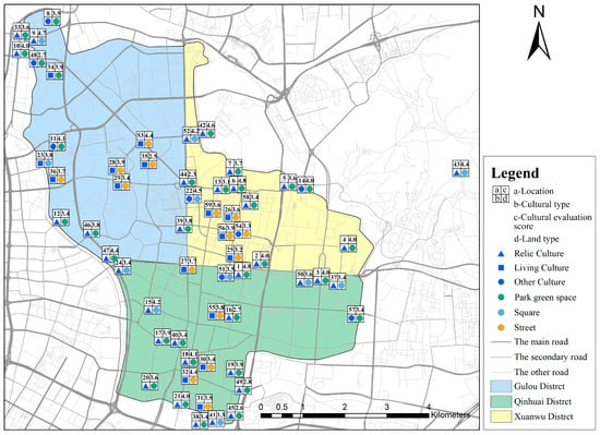
Figure 8.
Cultural map of open spaces in Nanjing’s old city.
The old city’s average score was 3.71. To further analyze the distribution characteristics of the cultural evaluation scores, this study compares the average scores across administrative districts and cultural types. As shown in Figure 9a, the average cultural value scores of Xuanwu (3.78), Qinhuai (3.62), and Gulou (3.76) Districts are relatively close, with Xuanwu slightly higher, indicating a generally balanced level of cultural resource value across the old city. As illustrated in Figure 9b, relic culture exhibits the highest average score (3.75), followed by living culture (3.69), while other culture scores relatively lower (3.57). These results align well with Nanjing’s status as a historical and cultural city, reflecting its abundant historical heritage and successful preservation efforts, while also demonstrating the vitality of living cultural practices.

Figure 9.
Comparison of cultural evaluation scores in Nanjing’s old city. (a) By administrative district; (b) by cultural type.
5.2. Density Evaluation and Analysis of the Cultural Spatial Structure
5.2.1. Overall Density
The overall cultural density of Nanjing’s old urban open spaces is 1.3/km2. The overall cultural densities by district are 1.5/km2 (Xuanwu), 1.3/km2 (Qinhuai), and 0.9/km2 (Gulou). Xuanwu District has the highest density of cultural resources, while Gulou District has a lower density. The open spaces in Nanjing’s old city are mainly concentrated in areas with cultural landmarks, historical sites, and favorable natural resources. Specifically distributed along the Ming City Wall, historical streets and alleys, as well as the moat, the banks of the Qinhuai River (such as Qingliang Mountain and Stone City Park relying on the monuments stored), Yueya Lake Park, and Wulong Pool Park are located along the Qinhuai River. Xinjiekou and Gulou Square are located in the city center, with squares designed to meet nearby residents’ needs. Xuanwu District retains a rich collection of historical relics and cultural sites.
5.2.2. Linear Density
To illustrate the relationship between cultural sites and the community, we used the city’s roads as the connecting lines between cultural sites. We mapped the roads between the 59 cultural sites with the network analysis tool in ArcGIS 10.8 to form the cultural space structure diagram (Figure 10). This was used to determine the spatial connection between cultural sites in Nanjing’s old urban open spaces. The four main cultural axes of Nanjing’s old city connect various cultural sites (relic or living culture) along their paths:
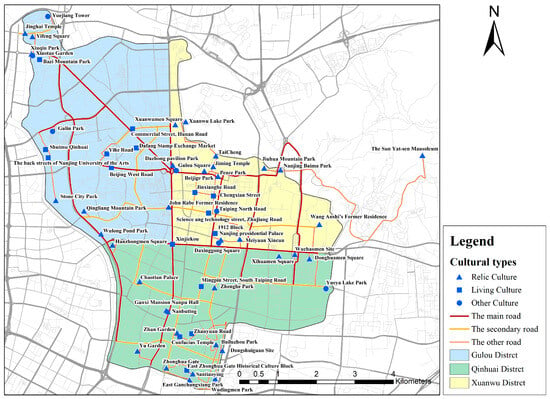
Figure 10.
Cultural space structure diagram of open spaces in Nanjing’s old city.
- Route 1: Taiping Gate Road–Longpan Road–Beijing East Road–Beijing West Road, 6.1 km. Connects six cultural sites; linear density of 1.0/km.
- Route 2: The line of Zhongshan Gate Street–Zhongshan East Road–Hanzhong Road, 6.5 km. Connects seven cultural sites; linear density of 1.1/km.
- Route 3: Central Road–Zhongshan Road–South Zhongshan Road–Zhonghua Road, 8.0 km. Connects 11 cultural sites; cultural linear density of 1.4/km.
- Route 4: Daqiao South Road–Huju North Road–Huju Road, 6.4 km. Connects 10 cultural sites; linear density of 1.6/km.
Linear density analysis further revealed the distribution characteristics of cultural resources along major transportation routes and tourist paths. Route 4 (Daqiao South Road–Huju Road) exhibited the highest cultural linear density, indicating a rich concentration of cultural resources along this axis, with high cultural accessibility and tourism value. However, the uneven overall distribution of cultural resources may lead to insufficient cultural experiences in certain areas, affecting citizens’ and visitors’ overall perception of Nanjing’s culture.
Cultural heritage sites showed some regional clustering. The central area had a higher concentration of cultural heritage sites, including historical cultural districts, modern commercial culture, and event centers. Cultural heritage sites were sparse in the eastern and northern areas, primarily owing to the fragmentation of the Ming City Wall. This has become a blind spot in green space management and lacks large-scale open spaces that can serve the community. Xuanwu District has the highest concentration of cultural sites, distributed linearly along the main roads. Qinhuai District has an uneven distribution. Sites are concentrated in the old city’s southern part but sparse elsewhere. In Gulou District, the western part showed a point-line-surface distribution, while the northern and eastern parts exhibited a clustered pattern.
5.3. Analyzing Cultural Resource Aggregation Patterns
Kernel density analysis, combined with cultural value scores, revealed the aggregation patterns of cultural value in Nanjing’s old city. Compared to living and other cultural sites, heritage cultural sites dominated in terms of quantity and distribution range. This formed a network of relic culture in the old city. The spatial distribution of relic culture exhibited a significant clustering pattern with uneven spatial distribution (Figure 11a). It was sparse in the northwest and southeast and dense in the southwest and northeast. A high-density cluster was formed around Beijige Park, Jiming Temple, and Heping Park. This area is therefore a comprehensive “hotspot” with concentrated and high-value heritage cultural resources in Nanjing’s old city. In the northwest, areas such as Yuejiang Tower, Gan Xi’s former residence in the south, Changxiang Park in the east, and the Wuchao Gate ruins in the east show moderate clustering with a point-based distribution. They exhibit a linear distribution trend from the south to the northwest and northeast. The results revealed the continuity and networked characteristics of the number and value of relic culture in Nanjing’s old urban open spaces. Thus, these heritage sites are not isolated but interconnected through spatial links, forming a relatively organic cultural ecosystem.
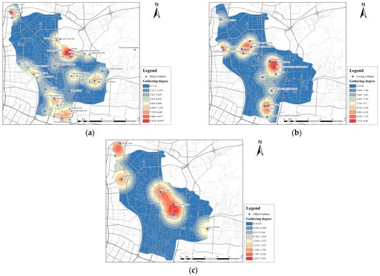
Figure 11.
(a) Aggregation patterns of cultural heritage sites; (b) aggregation patterns of living cultural sites; (c) aggregation patterns of other cultural sites.
Living cultural sites were concentrated in the central area, presenting a “multi-center aggregation” distribution pattern with fewer sites in surrounding areas (Figure 11b). The central area, with historically protected districts such as Yihe Road and Zhujiang Road, formed the core group. High cultural value and density create hotspots for living culture, which are connected through linear extensions to key living culture nodes such as Zhan Garden Road and the Confucius Temple. Most of these living culture sites are active historical neighborhoods, old parks, and squares. They reflect the city’s cultural vitality but are also an integral part of the community residents’ daily lives. The spatial analysis of cultural value further revealed the mobility and adaptability of living culture in the old city’s open spaces. This suggests that these cultural resources dynamically adapt to the development of urban functions and residents’ needs, thus maintaining their cultural vitality.
Other cultural sites had a dispersed spatial distribution showing a point-like discrete pattern, mostly near communities. Areas such as Taiping North Road and Daxinggong Square exhibited concentrated cultural value (Figure 11c). Not only do they provide spaces for daily communication and recreational activities for community, but they also offer potential space for developing new cultures. Relic culture represents the direct use of cultural achievements created by predecessors; living culture reflects citizens’ continuation and contribution to the culture initiated by their predecessors. Other culture signifies the emerging human–environment relationship, with community residents actively forming new cultural identities. The proximity of other cultural sites to communities further emphasized this dynamic.
5.4. Analyzing the Matching Degree Between the Cultural Map and Plans
To further validate the effectiveness of the cultural map as a planning tool, we compared the evaluation results with Nanjing’s existing urban planning, heritage preservation, and other relevant policy documents as follows.
The planned protection and control scope of the key conservation areas largely coincides with the evaluation results of this study. In September 2023, the latest version of the “Nanjing Historical and Cultural City Protection Plan” [57] entered the public consultation phase. The plan “designates four historically significant areas—South of the city, Ming Palace, Gulou—Qingliang Mountain, and Beijing East Road—as historical districts that need focused protection and control”. This designation closely aligns with the distribution of heritage cultural spaces shown on the cultural map (Figure 12).
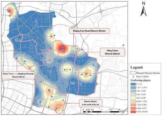
Figure 12.
Comparison of the Relic Culture Distribution.
The official identification of developable resources is largely consistent with the evaluation results of this study. The Nanjing Historical and Cultural City Protection Plan also states the need to “preserve and continue the overall pattern, spatial scale, and historical style of the street districts, maintaining the continuity and vitality of social life in these areas”. Documents such as the “Nanjing “14th Five-Year Plan for Culture and Tourism Development” [58] and “Conservation Plan for the Yilu Road Historical and Cultural District–Revitalization Plan for the Yilu Road Historical and Cultural District” [59], address similar issues, emphasizing the “integrated development of culture and tourism”. This resonates with the high concentration of living cultural resources in historical districts such as Yihe Road and Zhujiang Road, as indicated on the cultural map.
Compared with the assessment of this study, the planning of the cultural network lacks comprehensiveness and attention to residents. The Nanjing Historical and Cultural City Protection Plan further proposes the goal to “fully utilize the Ming city wall, city moat, Qinhuai River, and historical streets to repair, connect, and integrate, building an ancient capital’s cultural ecological network”. This aligns closely with the cultural axes outlined earlier (Figure 13). However, the cultural map and evaluation results indicate that the cultural resources of the old city still lack effective integration and utilization. Unlike the four cultural axes in Nanjing’s old city built upon the existing road network shown on the cultural map, the ancient capital cultural ecological network emphasizes historical corridors, including historical axes, streets, and waterways. It focuses on the logic and cohesiveness of textual planning but lacks attention to the public’s daily life. The reason for this is that these planning documents have not adequately considered other types of living culture, such as historical districts, city walls, and emerging spaces for community cultural development, beyond designated heritage sites. International studies and practices in preserving living heritage emphasize the relationship between heritage sites and communities, which is a crucial aspect overlooked by the aforementioned plans. The significance of constructing the cultural map lies in clarifying the relationship between culture and the public, promoting a comprehensive understanding of the old city’s cultural resources.
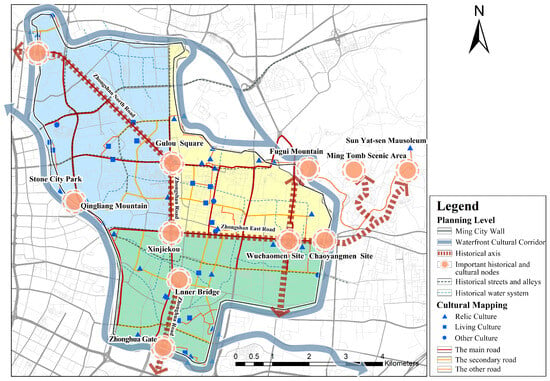
Figure 13.
Comparison of cultural axis planning.
5.5. Evaluation Results
Based on the evaluation data, the cultural map of Nanjing’s old urban open spaces reveals three key findings. First, Nanjing has successfully integrated heritage sites into open spaces like parks and squares. However, most relic culture is concentrated along the city’s scenic belt, serving primarily as static displays rather than fostering new cultural developments. While some living culture has been integrated into residents’ daily lives, challenges remain, including insufficient quantity, uneven distribution, and inadequate protection. For example, traditional districts like the GanXi blocks have been replaced by luxury villas. Other cultures are less evident due to rigid open space designs that lack flexibility and fail to inspire community creativity. Overall, the community has not been fully incorporated into cultural protection and development.
Second, the old city’s spatial structure is clear but imbalanced. Four cultural axes, connected by the Nanjing Circumvallation scenic belt, form a network covering the old city. However, cultural types are unevenly distributed. The overall cultural density varies across administrative areas, and the linear density of the four axes differs significantly. This imbalance suggests room for improvement in community-level cultural development.
Third, the cultural map aligns with Nanjing’s urban planning and heritage preservation goals, serving as an effective visualization tool. It highlights issues such as the limited number and uneven distribution of living culture resources, as well as the lack of integration of other cultural resources. Unlike the planned ancient capital cultural ecological network, which focuses on heritage, the cultural map emphasizes the connection between culture and the community. These issues remain unaddressed in existing plans, and the community has yet to play a central role in the sustainable development of cultural resources.
6. Discussion
6.1. Discussion of Results and Methods
This study, based on the Nanjing case, reveals several less-documented spatial patterns and planning issues. The evaluation results show significant differences in the spatial aggregation patterns of relic, living, and other cultures. This finding refines the “cultural core area” phenomenon observed by Kourtit & Nijkamp [3] at the global city scale, indicating that the spatial aggregation of high-value cultural resources exhibits diverse patterns and requires targeted conservation and activation strategies in planning. The uneven distribution of relic culture is attributed to Nanjing’s complex evolution from an ancient capital to a modernized metropolis, compounded by wartime destruction, which prevented the complete preservation of the urban structure from any single historical period. The insufficiency and uneven distribution of living culture echo the cultural spatial inequality issues highlighted by Currie and Correa [42]. The four cultural axes identified through linear density analysis reveal that cultural resources are primarily clustered along the city’s main transportation arteries, confirming the role of cultural mapping as a visual and dynamically adjustable route planning tool [7]. Furthermore, the matching degree analysis with existing urban planning policies indicates that Nanjing’s historical and cultural conservation plans highly align with the distribution of relic culture identified in this study but pay severely insufficient attention to ongoing living culture and emerging other culture. This resonates with the view of Florentin et al. [40] that urban planning will struggle to maintain sustainable cultural vitality without effectively incorporating bottom-up cultural narratives. Thus, cultural mapping can serve as an effective tool for connecting heritage site culture with the community.
This study presents a methodology for elucidating the real relationship between culture and people, establishing a new concept of cultural site. It divides the cultural aspects of old urban open spaces into relic, living, and other culture, moving beyond the traditional dualistic perspective, and examines the relationship between culture and community, which aligns with scholars’ emphasis on the importance of community participation in cultural policy [28,34,39,60,61]. The stock of heritage-type culture indicates whether the old city’s historical and cultural depth is substantial and whether preservation efforts are appropriate. The stock of living culture reflects the continuity of the old city’s culture and spatial vitality, while the stock of other cultures highlights the community’s role in creating a new urban citizen culture. Compared to previous studies that have employed methods such as the analytic hierarchy process [7,62,63] and system evaluation [64], this study reconstructed a nine-rectangle-grid evaluation system for old urban open spaces, overcoming the limitations of previous single-indicator approaches through multi-dimensional and categorized assessment. It considered three aspects: material elements, perceptual elements, and cultural connotations. The study designed cultural value assessment indicators, incorporating perceptual and cultural elements such as healthiness, authenticity, and popularity, thereby making the evaluation more aligned with the community’s actual usage experience and emotional identification [39], utilized GIS technology, and analyzed the spatial distribution structure and aggregation pattern of cultural resources in conjunction with the urban spatial structure based on cultural-value scoring. This contributes to visualizing, quantifying, and systematizing the cultural-resource value assessment of old urban open spaces. Furthermore, the matching analysis between the cultural mapping outcomes and urban planning documents transcends the traditional scope of cultural mapping applications limited to environmental impact assessment [60] or cultural resource valuation [3,63]. It elevates its application to the level of providing feedback and optimization for urban master planning, offering a more operational policy tool.
6.2. Applications of Cultural Mapping
Cultural mapping contributes to preserving and enhancing the old city’s unique characteristics. By providing a systematic and efficient way to assess the value, quantity, spatial distribution, and land-use status of cultural sites, cultural mapping allows planners to incorporate the social processes required for forming and developing culture into the old city’s planning. This ensures sustainable dynamics for preserving or reshaping the city’s unique character. Extensive data collection, analysis, and evaluation are completed within the cultural mapping process, thus streamlining the work for planners. As a highly integrated tool, cultural mapping significantly reduces time costs and enhances decision-making efficiency.
Second, cultural mapping supports the planning of cultural and creative industries in the old city [41]. The cultural mapping reflects the essential cultural elements required for fostering the growth of cultural and creative industries. This includes their influence, relevance to residents’ daily lives, and current land-use status. When treated as a platform, cultural mapping can be enhanced by integrating cultural geographic information, which translates social science theories into spatial representations. This approach facilitates cluster effects for cultural and creative industries through more effective planning.
Finally, cultural mapping promotes community involvement in the old city’s sustainable development. The methods presented in this study—the classification of cultural sites, cultural value evaluation, cultural density analysis, aggregation assessment, and the analysis of the matching degree between the cultural map and relevant plans—aim to deepen the understanding of the relationship between culture and community. These methods offer essential information to clarify the community’s role, support the establishment of cooperative models, and guide the formulation of sustainable development goals and action plans.
6.3. Limitations and Future Research Directions
This study has several limitations that should be addressed in future research. First, it primarily focuses on the status of cultural resources, lacking an in-depth analysis of their dynamic evolution process and future development trends. Furthermore, while the current methodological framework prioritizes the integration and comparison of cultural attributes, the relationship between cultural sites and their land-use boundaries has not been extensively explored and remains a subject for future research. Consequently, reflecting the dynamic nature and complexity of cultural resources is difficult. Future research should incorporate historical data and dynamic monitoring methods to provide a more comprehensive understanding of cultural resources. A layered approach should be introduced, positioning the open spaces in the old city as dynamic information systems that emphasize cultural diversity. By overlaying cultural maps from different periods, future studies can visualize the quantity and spatial distribution characteristics of cultural changes. At the same time, these studies can plan open spaces as sustainable living entities. Second, evaluation indicators in this study were primarily selected based on expert experience. This involves top-down judgment and may introduce subjectivity. Future studies can validate and optimize the evaluation indicator system. Bottom-up approaches and large-scale sample verification will enhance the objectivity of the evaluation results. Third, we further develop an accurate method to assess the relationship between old city culture and the community, providing a basis for formulating sustainable development plans that involve community participation. Finally, the scope and depth of cultural mapping applications still have room for expansion. In future research, we plan to design the cultural mapping of old urban open spaces as a GIS-based cultural information retrieval platform, further refining the evaluation indicators to provide intuitive and comprehensive information support for decision-makers, researchers, and the public.
7. Conclusions
Grounded in the real relationship between culture and urban residents, this study designed cultural mapping with cultural categories, cultural value scores, and land-use types as coordinates for cultural site information. It proposed an evaluation method for the status of cultural resources in old cities, using cultural density, cultural resource aggregation patterns and the matching degree between cultural mapping and relevant plans as key indicators. The academic contributions of this research are threefold. First, it establishes the concept and classification method of cultural sites in open spaces, fully considering the realistic relationship between culture and community residents. Second, the cultural mapping integrated spatial, categorical, value, and land-use information, providing an analytical base map to acquire useful planning data. Third, evaluating the status of cultural resources reveals their presence and operation in old urban open spaces. The cultural map of Nanjing’s old urban open spaces effectively characterizes the existence state and spatial structure features of three types of culture: relic, living, and other. The evaluation results of the current state of cultural resources show that the spatial structure derived from cultural density analysis, aggregation patterns obtained through kernel density analysis, and the matching degree between the cultural mapping and relevant plans provide a reference for adjustments to the development plans in Nanjing‘s old city, demonstrating the potential of cultural mapping as a tool for planning and research. Beyond old urban open spaces, the approach and methodology presented in this study can be applied and evaluated in broader contexts.
Supplementary Materials
The following supporting information can be downloaded at: https://www.mdpi.com/article/10.3390/buildings15183318/s1, Table S1: List of Government planning documents and literary sources.
Author Contributions
Conceptualization, F.Z. and B.Q.; methodology, F.Z. and B.Q.; software, X.Q. and W.L.; validation, P.S., B.Q. and H.Q.; formal analysis, X.Q. and W.L.; investigation, F.Z.; resources, F.Z.; data curation, F.Z. and W.L.; writing—original draft preparation, F.Z. and B.Q.; writing—review and editing, B.Q., X.Q.,W.L. and P.S.; visualization, X.Q. and W.L.; supervision, P.S. and H.Q.; project administration, B.Q.; funding acquisition, B.Q. All authors have read and agreed to the published version of the manuscript.
Funding
This research was funded by the Social Science Foundation of Jiangsu Province, China (No. 21YSD009); the Ministry of Education Planning Foundation on Humanities and Social Sciences (No. 19YJAZH072); the Seventh Jiangsu 333 High-level Talent Programme Phase Third-tier Cultivation Candidates Project (2024); the General Program of the National Natural Science Foundation of China (No. 31971721) and the Priority Academic Program Development of Jiangsu Higher Education Institutions (PAPD).
Data Availability Statement
The data presented in this study are available on request from the corresponding author. The data are not publicly available due to privacy.
Conflicts of Interest
The authors declare no conflicts of interest.
References
- Huang, L.; Zhao, W.; Xu, J. Urban Cultural Map and Urban Cultural Planning. Planners 2008, 24, 67–71. [Google Scholar]
- Low, S.M. Urban Public Spaces as Representations of Culture. Environ. Behav. 1997, 29, 3–33. [Google Scholar] [CrossRef]
- Kourtit, K.; Nijkamp, P. Urban Cultural Vanguards Why Culture Matters for Urban Success. J. Urban Manag. 2022, 11, 198–213. [Google Scholar] [CrossRef]
- Bandarin, F. Urban Conservation and Sustainable Development. Hist. Environ. Policy Pract. 2020, 11, 444–453. [Google Scholar] [CrossRef]
- Navas-Carrillo, D.; Navarro-de-Pablos, J. World Heritage and Sustainable Development: New Directions in World Heritage Management. Int. J. Herit. Stud. 2019, 25, 1231–1233. [Google Scholar] [CrossRef]
- Veldpaus, L. Reconnecting the City: The Historic Urban Landscape Approach and the Future of Urban Heritage. Cult. Trends 2015, 24, 340–342. [Google Scholar] [CrossRef]
- Zhang, S.; Lin, J.; Feng, Z.; Wu, Y.; Zhao, Q.; Liu, S.; Ren, Y.; Li, H. Construction of Cultural Heritage Evaluation System and Personalized Cultural Tourism Path Decision Model: An International Historical and Cultural City. J. Urban Manag. 2023, 12, 96–111. [Google Scholar] [CrossRef]
- Li, Y.; Sahari, F. The Application of Regional Culture in Urban Public Space Design. Cogent Arts Humanit. 2022, 9, 2116773. [Google Scholar] [CrossRef]
- Zhou, G. A Brief Analysis of Cultural Maps. Bull. Surv. Mapp. 2016, 3, 134–137, 145. [Google Scholar] [CrossRef]
- Brown, S.; Goetcheus, C. Routledge Handbook of Cultural Landscape Practice; Routledge: London, UK, 2023. [Google Scholar]
- Ma, J.J. Traditional Fashion Practice and Cultural Sustainability: A Case Study of Nubi in Korea. Fash. Pract. 2023, 15, 64–90. [Google Scholar] [CrossRef]
- Artese, M.T.; Gagliardi, I. Integrating, Indexing and Querying the Tangible and Intangible Cultural Heritage Available Online: The QueryLab Portal. Information 2022, 13, 260. [Google Scholar] [CrossRef]
- Australia ICOMOS (The International Council on Monuments and Sites). The Burra Charter: The Australia ICOMOS Charter for Places of Cultural Significance; Australia ICOMOS Incorporated: Burwood, Australia, 2013. [Google Scholar]
- Ireland, T.; Brown, S.; Bagnall, K.; Lydon, J.; Sherratt, T.; Veale, S. Engaging the Everyday: The Concept and Practice of ‘Everyday Heritage’. Int. J. Herit. Stud. 2025, 31, 192–215. [Google Scholar] [CrossRef]
- Lefebvre, H. The Production of Space; Blackwell Publishing: Oxford, UK, 1991. [Google Scholar]
- Miles, A.; Gibson, L. Everyday Participation and Cultural Value in Place. Cult. Trends 2017, 26, 1–3. [Google Scholar] [CrossRef]
- The United Nations Educational, Scientific and Cultural Organization (UNESCO). Culture | 2030 Indicators; The United Nations Educational, Scientific and Cultural Organization (UNESCO): Paris, France, 2019; ISBN 9789231003554. [Google Scholar]
- Qiao, W.; Pang, S.; Guo, M. Cultural Heritage Evaluation Based on Analytic Hierarchy Process and Fuzzy Control: Case Study of the South Manchuria Railway in China. Buildings 2025, 15, 102. [Google Scholar] [CrossRef]
- Zhang, Y.; Han, Y. Vitality Evaluation of Historical and Cultural Districts Based on the Values Dimension: Districts in Beijing City, China. Herit. Sci. 2022, 10, 137. [Google Scholar] [CrossRef]
- Dong, W.; Han, W.; Xu, Y.; Wang, J. Evaluation of the Contemporary Cultural Landscape Based on Multi-Dimensional Value Coupling: Case Study on the Grand Canal, Hangzhou Section. PLoS ONE 2025, 20, e0330248. [Google Scholar] [CrossRef]
- Lian, W.; Dimitrijević, B. Analytic Hierarchy Process-Based Industrial Heritage Value Evaluation Method and Reuse Research in Shaanxi Province—A Case Study of Shaanxi Steel Factory. Sustainability 2025, 17, 4125. [Google Scholar] [CrossRef]
- Wang, H.; Ye, M.; Wang, S. Context and Research Origins of Cartography. Archit. Cult. 2015, 8, 194–195. [Google Scholar]
- Teather, E.K. Mappings: Denis Cosgrove (Ed.), Reaktion Books (Critical Views Series), London, 1999, 311pp, ISBN 1-86189-021, Price 16.95, US$27.00(Pbk). J. Rural. Stud. 2000, 16, 510–511. [Google Scholar] [CrossRef]
- Mirowski, P. A Brief History of Neoliberalism, David Harvey. Oxford University Press, 2005, Vii + 247 Pages. Econ. Philos. 2008, 24, 111–117. [Google Scholar] [CrossRef]
- Crawhall, N. The Role of Participatory Cultural Mapping in Promoting Intercultural Dialogue: We Are Not Hyenas; a Reflection Paper; The United Nations Educational, Scientific and Cultural Organization (UNESCO): Paris, France, 2010. [Google Scholar]
- Birge-Liberman, P. Cultural Mapping as Cultural Inquiry. Soc. Cult. Geogr. 2016, 17, 603–604. [Google Scholar] [CrossRef]
- Barnes, A. “Ooh It Were Mucky”: Mapping Memories of New Basford, Nottingham. Cult. Geogr. 2023, 30, 187–203. [Google Scholar] [CrossRef]
- Duxbury, N.; Garrett-Petts, W.F. Re-Situating Participatory Cultural Mapping as Community-Centred Work. In The Routledge Handbook of Cartographic Humanities; Routledge: London, UK, 2024; pp. 329–338. ISBN 978-1-003-32757-8. [Google Scholar]
- Huang, Y.; He, X.; Lian, Z.; Yang, Z.; Jiang, Q. Mapping the Landscape of Marine Cultural Heritage Research from 2000 to 2023: A Bibliometric Analysis. Mar. Policy 2024, 163, 106086. [Google Scholar] [CrossRef]
- Ferguson, R.; Joyce, K.E.; Reepmeyer, C.; Groom, R.; Pollard, K. A Scoping Review of Indigenous Cultural Mapping of Coastal, Island, and Marine Environments. Environ. Sci. Policy 2025, 164, 103991. [Google Scholar] [CrossRef]
- Mouttaki, I.; Khomalli, Y.; Maanan, M.; Bagdanavičiūtė, I.; Rhinane, H.; Kuriqi, A.; Pham, Q.B.; Maanan, M. A New Approach to Mapping Cultural Ecosystem Services. Environments 2021, 8, 56. [Google Scholar] [CrossRef]
- Fusté-Forné, F. Mapping Heritage Digitally for Tourism: An Example of Vall de Boí, Catalonia, Spain. J. Herit. Tour. 2020, 15, 580–590. [Google Scholar] [CrossRef]
- Su, S.; Wu, L.; Du, Q.; Kang, M.; Weng, M. Theoretical Framework and Practical Cases in the Design of Urban Cultural Atlases. Surv. Sci. 2021, 46, 145–152. [Google Scholar] [CrossRef]
- Mukwidigwi, T.; Naidu, M.; Govender, S.; Membele, G. The Spatial Nexus of Monuments, Memorability and Identity Formation in Chatsworth and Durban Central, South Africa. GeoJournal 2023, 88, 5643–5660. [Google Scholar] [CrossRef]
- Cauchi-Santoro, R. Mapping Community Identity: Safeguarding the Memories of a City’s Downtown Core. City Cult. Soc. 2016, 7, 43–54. [Google Scholar] [CrossRef]
- Kong, X.; Chen, P.; Wen, Y. A Preliminary Exploration of the Role of Cultural Maps in Constructing Collective Memory of Urban Neighborhoods: Based on the “Memory Jiangning” Initiative. J. East China Norm. Univ. (Humanit. Soc. Sci.) 2019, 51, 205–213+243–244. [Google Scholar] [CrossRef]
- Savić, J. Sense(s) of the City: Cultural Mapping in Porto, Portugal. City Cult. Soc. 2017, 11, 12–19. [Google Scholar] [CrossRef]
- Sletto, B.; de la Torre, G.B.; Luguana, A.M.L.; Pereira, D. Walking, Knowing, and the Limits of the Map: Performing Participatory Cartographies in Indigenous Landscapes. Cult. Geogr. 2021, 28, 611–627. [Google Scholar] [CrossRef]
- Lettau, M. Participatory Methodological Approaches for Regenerative Cultural Policy. The Case Study of Cultural Mapping in the Public Library of Ravensburg. Int. J. Cult. Policy 2025, 31, 482–496. [Google Scholar] [CrossRef]
- Florentin, K.M.; Onuki, M.; Esteban, M. Cultural Mapping in Smart Sustainable Cities: The Kashiwanoha Monogatari Project. Cult. Trends 2025, 34, 38–61. [Google Scholar] [CrossRef]
- De Abreu Santos, V.Á.; van der Borg, J. Cultural Mapping Tools and Co-Design Process: A Content Analysis to Layering Perspectives on the Creative Production of Space. Sustainability 2023, 15, 5335. [Google Scholar] [CrossRef]
- Currie, M.; Correa, M.M. Tangibles, Intangibles and Other Tensions in the Culture and Communities Mapping Project. Cult. Trends 2022, 31, 88–106. [Google Scholar] [CrossRef]
- Lee, D.; Gilmore, A. Mapping Cultural Assets and Evaluating Significance: Theory, Methodology and Practice. Cult. Trends 2012, 21, 3–28. [Google Scholar] [CrossRef]
- Duxbury, N.; de Castro, T.V.; Silva, S. Culture–Tourism Entanglements: Moving from Grassroots Practices to Regenerative Cultural Policies in Smaller Communities. Int. J. Cult. Policy 2025, 31, 497–516. [Google Scholar] [CrossRef]
- Freitas, R. Cultural Mapping as a Development Tool. City Cult. Soc. 2016, 7, 9–16. [Google Scholar] [CrossRef]
- Huang, Y.; Yang, S. Mapping Suzhou’s Cultural Heritage Sites: Exploring Gusu Prosperous Map through Data Visualization. ACM J. Comput. Cult. Herit. 2025, 18, 1–26. [Google Scholar] [CrossRef]
- Zhang, Z. Bridging Historical Maps to Urban Cultural Maps: A Comparative Analysis of Beijing Cultural Maps. Resour. Dev. Mark. 2014, 30, 59–62. [Google Scholar]
- Fu, Q.; Lu, L. The 1929 “Capital Plan” and Nanjing. Arch. Constr. 2009, 10, 48–50. [Google Scholar]
- Song, Y. Interpreting the Historical and Cultural Ideology of the 1929 Nanjing “Capital Plan”: The Contest of Political, Academic, and Social Forces. Urban Dev. Stud. 2022, 29, 33–38, 48. [Google Scholar]
- Li, B.; Xiong, H. Historical Study on the Urban Transformation and Urban Planning of Modern Nanjing. City Plan. 2003, 27, 46–52, 71. [Google Scholar]
- CJJ/T 85-2017; Standard for Classification of Urban Green Space. China Architecture & Building Press: Beijing, China, 2017.
- CJJ/T 85-2002; Standard for Classification of Urban Green Space. China Architecture & Building Press: Beijing, China, 2002.
- Wang, X.; Zhang, T.; Duan, L.; Liritzis, I.; Li, J. Spatial Distribution Characteristics and Influencing Factors of Intangible Cultural Heritage in the Yellow River Basin. J. Cult. Herit. 2024, 66, 254–264. [Google Scholar] [CrossRef]
- Zhang, W.; Ma, L.; Xu, J.; Peng, Y. Spatial–Temporal Distribution Characteristics and Influencing Factors of Immovable Cultural Heritage in Hubei, China. Sci. Rep. 2025, 15, 24570. [Google Scholar] [CrossRef] [PubMed]
- Silverman, B.W. Density Estimation for Statistics and Data Analysis; Chapman and Hall: London, UK, 1986. [Google Scholar]
- Duxbury, N. Positioning Cultural Mapping in Local Planning and Development Contexts: An Introduction. Cult. Local Gov. 2015, 5, 1–7. [Google Scholar] [CrossRef]
- Nanjing Planning and Natural Resources Bureau. Conservation Plan for the Historic City of Nanjing (Public Consultation). Available online: https://ghj.nanjing.gov.cn/pqgs/ghbzpqgs/202309/t20230927_4021377.html (accessed on 10 September 2025).
- General Office of Nanjing Municipal People’s Government. Notice on Issuing the Nanjing Municipal Plan for Culture and Tourism Development during the 14th Five-Year Plan Period; Ningzhengbanfa [2021] No. 73. Available online: https://www.smejs.cn/policy_show.aspx?id=8705e19cdd4a40aabd577fa5cb05c0ac (accessed on 10 September 2025).
- Nanjing Planning and Natural Resources Bureau. Regulatory Detailed Plan for the Old City of Xuanwu, Nanjing: Revisions to the Regulatory Diagram for Planning Management Unit NJZCa020-13 (Public Consultation). Available online: https://ghj.nanjing.gov.cn/pqgs/ghbzpqgs/202502/t20250207_5070101.html (accessed on 10 September 2025).
- Muir, B.R. Practices, Events, and Effects: Improving Causal Analysis with the Geographic Information from Cultural Mapping in Canada. Environ. Impact Assess. Rev. 2025, 110, 107686. [Google Scholar] [CrossRef]
- Aboulnaga, M.; Abouaiana, A.; Puma, P.; Elsharkawy, M.; Farid, M.; Gamal, S.; Lucchi, E. Climate Change and Cultural Heritage: A Global Mapping of the UNESCO Thematic Indicators in Conjunction with Advanced Technologies for Cultural Sustainability. Sustainability 2024, 16, 4650. [Google Scholar] [CrossRef]
- Wang, Z.; Ma, J. Cultural Value Evaluation of Street-Avenue Modeling Trees in Historic Cities: A Case Study of Ganjiang Road, Suzhou. Garden 2024, 41, 108–116. [Google Scholar]
- Huang, X.; Gee, L.L.S.; Achin, I.A. Research on Cultural Value Evaluation of Ciqikou Architecture Based on AHP Method. Adv. Educ. Humanit. Soc. Sci. Res. 2022, 1, 137. [Google Scholar] [CrossRef]
- Schultz, M.; Jamieson, H.; Piontek, E.; Coon, J.J.; Halsey, S.J. The Importance of Cultural Values in Ecological Restorations: A Systematic Review. Soc. Nat. Resour. 2022, 35, 1021–1039. [Google Scholar] [CrossRef]
Disclaimer/Publisher’s Note: The statements, opinions and data contained in all publications are solely those of the individual author(s) and contributor(s) and not of MDPI and/or the editor(s). MDPI and/or the editor(s) disclaim responsibility for any injury to people or property resulting from any ideas, methods, instructions or products referred to in the content. |
© 2025 by the authors. Licensee MDPI, Basel, Switzerland. This article is an open access article distributed under the terms and conditions of the Creative Commons Attribution (CC BY) license (https://creativecommons.org/licenses/by/4.0/).