Abstract
The spatial relationships of the widely distributed latest Jurassic–Early Cretaceous igneous rocks in the Tethyan Himalaya, northeastern India, and southeastern Australia are crucial for understanding the breakup of eastern Gondwana. However, available paleomagnetic datasets from the central Tethyan Himalaya are limited. To better constrain the distribution of these igneous rocks, new paleomagnetic data were obtained from the Weimei Formation volcanic rocks in the central Tethyan Himalaya. The tilt-corrected site-mean directions for 11 sites is Ds = 315.4°, Is = −58.4°, ks = 17.2, α95 = 11.3°, corresponding to a paleopole at 9.6° N, 297.3° E with dp/dm = 16.7°/12.4° and a paleolatitude of ~39.1 ± 12.4° S for the study area (29.7° N, 83.7° E). A positive regional fold test and the occurrence of dual polarity suggest that the characteristic remanent magnetization is of pre-fold origin. These new results, together with those from the eastern Tethyan Himalaya, northern India, and southwestern Australia, show that the ~147–130 Ma circum-eastern Gondwana large igneous province spans a latitudinal range of ~40.7–58.1° S, centered at ~49.4° S, which is consistent with the present Kerguelen hotspot (~49.0° S). Integrating other evidence, we consider that the Kerguelen mantle plume played a key role in the breakup of eastern Gondwana.
1. Introduction
The links between the breakup of eastern Gondwana and the Kerguelen mantle plume (KMP)-triggered large igneous province (LIP) remain a topic of debate [1,2,3,4]. Eastern Gondwana comprises Antarctica, Australia, and Greater India (present-day India plus a postulated northern extension) [5]. The Tethyan Himalaya (TH) refers to the northern margin of Greater India [5,6]. The oldest seafloor spreading magnetic anomalies between Greater India–Antarctica (M9o, ~130.2 Ma) [7] and Greater India–Australia (M10, ~130.2 Ma) [8] were roughly contemporaneous, implying that the breakup of eastern Gondwana occurred at ~130 Ma. Greater India and Australia host a large number of ~147–130 Ma igneous rocks associated with the KMP (Figure 1), which are mainly distributed at the eastern TH [3,9,10,11,12], northeastern India [13,14], and southwestern Australia [15], collectively referred to as the circum-eastern Gondwana LIP. Although investigations of these igneous rocks have lasted for decades, the relationship between the breakup of eastern Gondwana and the KMP remains tentative [2,3,9,16,17].
There are two perspectives regarding the breakup of eastern Gondwana: (1) the widely distributed ~147–130 Ma mafic rocks in the TH and southwestern Australia derived from the KMP which played a significant role in the breakup of eastern Gondwana [3,9,10,16]; (2) the igneous rocks from southwestern Australia could also be interpreted as the products of decompression melting of an enriched mantle source [15], and passive rifting of Greater India from Australia–Antarctica before ~130 Ma eventually led to the rupture of the continental lithosphere [2,18,19], without the influence of a mantle plume. A key point of the debates arises from the considerable distance (>1000 km) between the paleogeography of the ~147–130 Ma mafic rocks or the breakup nexus and the location of the KMP [2,20].
Previous investigations only identified the ~130 Ma mafic dykes associated with the KMP in the Zhongba area of the central TH [21], while the limited age and spatial distribution led to some suspicion about whether the Early Cretaceous igneous rocks in the central TH are genuinely related to the KMP [17]. Recent investigations have revealed extensive volcanic sequences dated to ~144–124 Ma within the Late Jurassic–Early Cretaceous strata of the central TH, and their Sr–Nd–Hf–Pb–Os isotope data exhibit clear affinities to the KMP [11,18,19,22,23,24]. Importantly, no other igneous rocks of contrasting origin (e.g., subduction-related or syn-collisional) have been reported from the TH for this specific period, effectively ruling out alternative tectonic mechanisms. These consistent geochemical signatures and contemporaneous ages indicate that the ~147–130 Ma mafic magmatism extends continuously from southwestern Australia and northeastern India through the eastern TH to the Zhongba area in the central TH.
However, because of the movements of Greater India and Australia [25,26], the abovementioned igneous rocks associated with the KMP have been widely dispersed from their initial emplacement position. Reconstructing the paleogeography of the circum-eastern Gondwana LIP is therefore essential for understanding the original distribution of these KMP-related igneous rocks. Paleomagnetism could provide crucial clues to the initial paleolatitude of the LIP. To date, however, the relevant research has focused mainly on ~147–130 Ma volcanic rocks from southwestern Australia, northeastern India, and the eastern TH [27,28,29,30,31], with very limited data available from coeval volcanic rocks in the central TH [23].
In this contribution, we present new paleomagnetic data obtained from the volcanic rocks of the Weimei Formation in the central TH. These new results not only confirm previous findings but also help clarify the ~147–130 Ma circum-eastern Gondwana LIP, thereby providing a better understanding of the breakup of eastern Gondwana.

2. Geology and Sampling
The Himalayan Orogeny (Figure 1), located to the south of the Tibetan Plateau and the north of India, consists of four thrust-bounded tectonic units (Figure 2a): the Tethyan Himalaya, the Greater Himalaya (GH), the Lesser Himalaya (LH), and the Sub-Himalaya (SH), which are bounded from north to south by the Indus-Tsangpo Suture Zone (ITSZ), the South Tibetan Detachment System, the Main Central Thrust, and the Main Boundary Thrust [36]. The TH sequence comprises Ordovician to Eocene sedimentary rocks, partially interlayered with igneous rocks [26]. The Himalayan orogen can be divided along its strike into western (66–81° E), central (81–89° E), and eastern (89–98° E) segments [36].
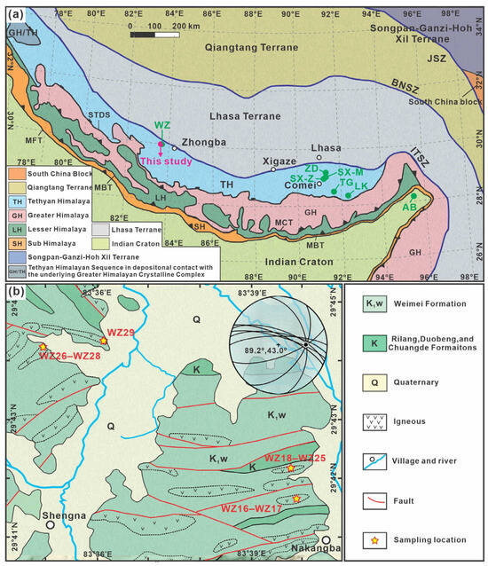
The study area is situated near the Shengna and Nakangba villages of Zhongba county in the central TH, where the Late Jurassic and Cretaceous sedimentary rocks, interbedded with igneous rocks, are widely distributed. The exposed strata include the Early Cretaceous Weimei Formation, and Cretaceous Rilang, Duobeng, and Chuangde Formations (Figure 2b) [21]. The Weimei Formation is composed of sandstones and shales interbedded with igneous rocks. Previous biostratigraphic studies, based on lithological characteristics and radiolarian fossil assemblages, assigned the Weimei Formation to the Late Jurassic [21]. However, recent U–Pb geochronological analyses of igneous rocks within this formation have yielded ages of ~144.3–130 Ma [21,23]. The zircon U–Pb dating results also reveal that volcanic rocks of the Weimei Formation in the eastern TH have an age range of ~138–130 Ma [3,27]. Additionally, the lowest part of the volcaniclastic sandstones of the overlying Rilang Formation in the Zhongba area yielded a U–Pb age peak of 134 ± 4 Ma [37]. The aforementioned geochronological data support the interpretation that the Weimei Formation in the central TH, consistent with the findings from the eastern TH [27], formed during the Early Cretaceous rather than the Late Jurassic as previously proposed [23]. Therefore, this study constrains the age of the Weimei Formation volcanic rocks in the Zhongba area to ~144–130 Ma.
A total of 14 paleomagnetic sites, including 140 oriented samples, were collected from four outcrop localities of volcanic rocks (Figure 2 and Figure 3). Sites WZ16–WZ17 (29.69° N, 83.67° E) were drilled from a hill located ~2 km southwest of the Nakangba village, where the sedimentary strata dip ~70° toward the north. Sites WZ18–WZ25 (29.70° N, 83.67° E) were collected along three exposed outcrops located ∼3 km southwest of the Nakangba village, where the sedimentary strata dip ~65–76° toward the north. Sites WZ26–WZ28 (29.74° N, 83.57° E) and site WZ29 (29.74° N, 83.60° E) were sampled beside the road, located ~5.5 km north of the Shengna village, where the sedimentary strata dip ~48–70° toward the southeast and ~42° toward the east. In general, every paleomagnetic site contains ten core samples (Figure 3i) taken with a portable gasoline-powered drill. The cores are oriented using a magnetic compass and adjusted according to the local magnetic declination. These volcanic rocks contain abundant phenocrysts and volcanic glass, which consists of plagioclase, pyroxene, and secondary altered chlorite (Figure 4).
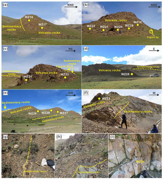
Figure 3.
Photographs showing (a–f) field outcrops of the sampling sections, (g,h) the beddings of adjacent sedimentary rocks, and (i) a representative sampling site.
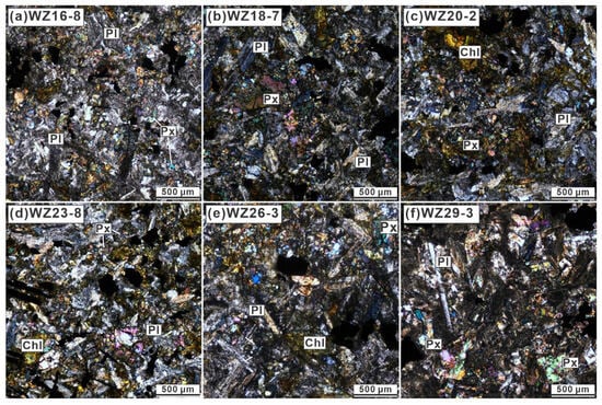
Figure 4.
Photomicrographs of representative samples. Abbreviations: Pl = plagioclase, Px = pyroxene, Chl = chlorite.
3. Methods
Isothermal remanent magnetization (IRM) and back-field demagnetization of saturation IRM were performed using an IM-10-30 impulse magnetizer (ASC Scientific, Narragansett, RI, USA) and were measured using an JR-6A spinner magnetometer (AGICO, Brno, Czech). The three-axis IRM was imparted in successively fields of 2.4 T, 0.4 T, and 0.12 T along three mutually orthogonal directions. The temperature dependence of magnetic susceptibility (k-T curves) for the representative specimens was measured in an argon atmosphere using a KLY-3S Kappabridge (AGICO, Brno, Czech) equipped with a CS-3 high-temperature furnace.
The specimens underwent progressive thermal and alternating field (AF) demagnetization processes. Generally, demagnetization temperature intervals were set to 80–50 °C below 200 °C and subsequently reduced to 30–10 °C until the maximum unblocking temperature in an ASC-TD 48 furnace with an internal residual field of less than 10 nT. The AF intervals were set to 2–10 mT below 60 mT and shifted to 20 mT above 60 mT in a D-2000 ASC Scientific AF demagnetizer. Remanent magnetization was measured using a 2G-755-4K cryogenic magnetometer (2G Enterprises, California, USA) or a JR-6A spinner magnetometer (AGICO, Brno, Czech). All remanence measurements were performed within a shielded room with a residual field of less than 300 nT at the Paleomagnetic and Environmental Magnetism Laboratory, China University of Geosciences, Beijing. The remanence directions of paleomagnetic specimens were determined using principal component analysis [38]. Site-mean directions were calculated using Fisherian statistics [39].
4. Rock Magnetism Results
The representative IRM acquisition curves climb steeply below 160–200 mT and reach saturation at about 500 mT (Figure 5a,c). The back-field demagnetization curves reveal coercivities of 90–100 mT and 30–40 mT. Coercivity component analysis of the former sample indicates a low-coercivity component (91 mT) contributing 45% and a medium-coercivity component (143 mT) contributing 55% to the whole SIRM (Figure 5b). The latter sample is dominated by a low-coercivity component (39 mT, 78%), with a minor medium-coercivity contribution (170 mT, 22%) (Figure 5e). Thermal demagnetization of three-axis IRM curves shows a clear unblocking temperature of ~550–580 °C (Figure 5c,f). The heating curves for both samples exhibit a significant increase in magnetic susceptibility, followed by an abrupt drop at ~560–580 °C (Figure 5g,h), consistent with the Curie temperature of magnetite. The fact that the cooling curve lies above the heating curve indicates the formation of new magnetite during heating. In addition, the heating curves also show subtle losses in magnetic susceptibility during ~580–620 °C (Figure 5g,h), possibly reflecting the presence of maghemite or titanomaghemite. Notably, the complex variations in the heating curve, caused by significant mineral alteration, prevent the effective identification of magnetic minerals.
The representative samples contain a significant proportion of medium-coercivity minerals. However, the fact that their unblocking temperatures remain mostly below 580 °C may indicate the presence of titanomagnetite. Several lines of evidence support this interpretation: (1) Titanomagnetite could increase the coercivity and decrease the Curie temperature [40]; (2) Fe-Ti oxides are commonly found in the LIP [41]; and (3) Previous studies on Early Cretaceous volcanic rocks in the same area have reported titanomagnetite [23]. Therefore, it is likely that the remanence in these samples is carried predominantly by low-coercivity magnetite and medium-coercivity titanomagnetite.

Figure 5.
(a,d) Isothermal remanent magnetization (IRM) acquisition curves, (b,e) the corresponding component analyses of coercivity distributions [42], back-field demagnetization of saturation IRM. (c,f) Thermal demagnetization of three-axis IRM, and (g,h) High-temperature heating (red) and cooling (blue) curves of bulk magnetic susceptibility in argon for the representative volcanic rock specimens of the Weimei Formation.
5. Paleomagnetic Results
Representative demagnetization diagrams are presented in Figure 6. Because most specimens exhibited stable remanent magnetization directions during stepwise thermal and alternating fields demagnetization, few low-temperature and low-coercivity components can be determined. A high-temperature component (HTC) or a high-coercivity component (HCC) toward the origin can be determined between 230 °C and 580 °C, or between 20 mT and 100 mT (Figure 6a–e, Table S1). The HTC and HCC directions, defined as the characteristic remanent magnetization (ChRM) directions, include antipodal normal and reverse polarities (Table 1). Notably, some specimens exhibit scattered demagnetization paths (Figure 6f), and no ChRM was determined. The following filtering criteria were applied for the ChRM and site-mean directions: (a) the ChRM is anchored to the origin and calculated from a minimum of five demagnetization steps, (b) each ChRM direction has the maximum angular deviation value ≤ 10°, (c) each valid site-mean direction was derived from at least five specimens, and (d) the α95 confidence cone around the site-mean direction must have a radius of ≤15°.
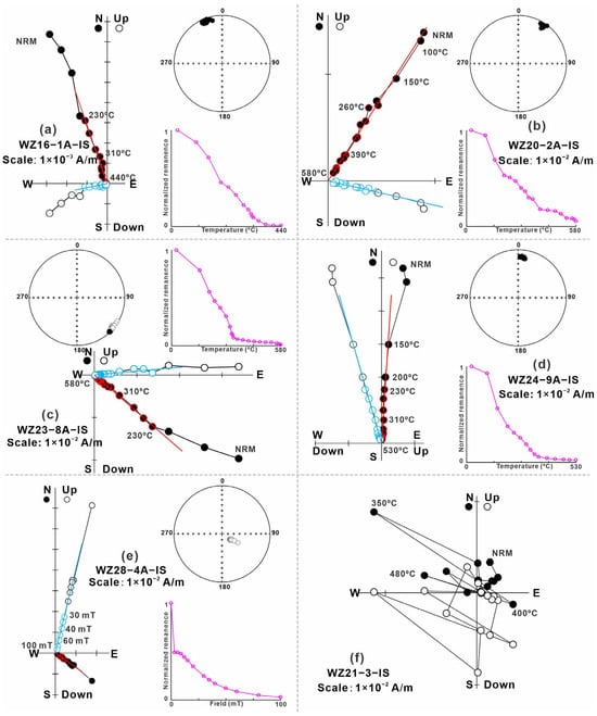
Figure 6.
Representative orthogonal demagnetization diagrams of the Weimei Formation volcanic rocks from the Zhongba area in geographic coordinates, and the corresponding equal-area Stereonets and the normalized demagnetization curves. The solid (open) symbols represent projections onto the horizontal (vertical) plane. NRM, natural remanent magnetization.

Table 1.
Site mean directions of the Weimei Formation volcanic rocks from Zhongba county in the central Tethyan Himalaya.
As a result, 11 paleomagnetic sites, including 70 specimens, provide the individual sample direction and site-mean directions. A comparative analysis confirms that the ChRM directions isolated by the thermal (Ds = 316.5°, Is = −59.6°, ks = 10.0, α95 = 7.0°) and alternating field (Ds = 315.2°, Is = −56.5°, ks = 24.9, α95 = 6.0°) demagnetization methods are consistent within analytical uncertainty (Figure 7a,b). The overall mean direction A from the 11 sites is Dg = 356.2°, Ig = −30.5°, kg = 2.4, α95 = 38.6° in situ, and Ds = 315.4°, Is = −58.4°, ks = 17.2, α95 = 11.3° after tilt correction (Figure 7c,d), corresponding to a paleomagnetic pole at 9.6° N, 297.3° E, with dp/dm = 16.7°/12.4° and a paleolatitude of ~39.1° ± 12.4° S for the study area (29.7° N, 83.7° E). These mean directions pass the McElhinny [43] fold test (ks/kg = 7.28 > F(20,20)95% = 2.12 and F(20,20)99% = 2.94) and the McFadden [44] fold test (in situ ξ1 = 7.63 and ξ2 = 9.20, tilt-corrected ξ1 = 0.42 and ξ2 = 2.53, the critical ξ value = 3.87 and 5.38 at 95% and 99% confidence levels). The Watson and Enkin [45] fold test shows an optimal unfolding at 100% (Figure 7e), indicating a pre-folding origin for the magnetization. The A95 value of 16.1°, calculated from 11 virtual geomagnetic poles (VGPs, Table S2), falls within the expected confidence envelope (4.6–18.1°) for N = 11 [46], supporting that our dataset of 11 sites cannot be rejected by the Deenen et al. [46] criteria and is therefore statistically consistent with other datasets considered to provide a reasonable average of paleosecular variation.
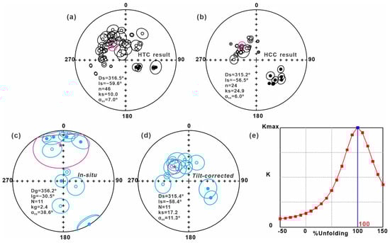
Figure 7.
(a,b) Equal-area projections of the sample-mean directions after tilt-correction. (c,d) Equal-area projections of the 11 site-mean directions before and after tilt-correction. (e) Results of stepwise unfolding of the 11 site-mean directions [45]. HTC, high-temperature component; HCC, high-coercivity component; Red and purple stars indicate the overall mean directions; Solid (open) circles show lower (upper) hemisphere projections; Black circles denote the directions of individual specimens; Blue circles represent the site mean directions.
Given the tectonic complexity of the TH region, we evaluated the impact of the potential plunging folds on the remanence directions. The sampling sections can define a fold axis trending 89.2° with a plunge of 43.0° (Figure 2b). After applying an inclined axis correction, the new site-mean direction B (Dp = 327.8°, Ip = −61.0°, α95 = 14.0°) is statistically indistinguishable from the direction A obtained without the correction (Ds = 315.4°, Is = −58.4°, α95 = 11.3°) at the 95% confidence level. These results suggest that the potential plunging folds have a negligible influence on the observed directions. We therefore adopt the uncorrected site-mean direction for the following discussion.
6. Discussion
Meert et al. [47] proposed seven “R” reliability criteria for evaluating the reliability of paleomagnetic datasets, including the well-limited age (R1), multiple demagnetization methods, and sufficient samples to average the VGPs (R2), rock magnetic and microscopic identification of magnetic carriers (R3), existence of field test (R4), clear tectonic setting (R5), positive reversal test (R6) and no resemblance to younger poles (R7). In this study, the paleomagnetic data used for LIP reconstruction must satisfy criteria R1–R3, R5, and R7, as well as either R4 or R6. All selected paleomagnetic data (Table 2) are associated with products of the KMP, and their ages are constrained by isotopic dating.
Table 2.
Summary of the paleomagnetic data observed from the products of the KMP.
6.1. The Spatial Relationship Between the KMP and the Circum-Eastern Gondwana LIP
As mentioned above, similarities in age, major and trace elements, and Sr-Nd-Hf-Pb-Os isotope ratios of the ~147–130 Ma circum-eastern Gondwana LIP suggest that they are the products of the KMP, including the ~147–130 Ma magmatic rocks from the eastern TH [3,9,10,16,17] to central TH [11,21,22], the ~145–130 Ma Abor igneous rocks in northeastern India [13,14], the ~137–130 Ma Bunbury basalts [15,20] and the ~132–128 Ma Naturaliste Plateau igneous rocks [35] in southwestern Australia.
For the eastern TH (Table 2), Yang et al. [31] obtained a paleomagnetic pole (LK) from the Lakang Formation lava flows, which were initially assigned a Hauterivian (~134–131 Ma) age based on bivalve fossils. However, subsequent U–Pb dating indicates a Late Jurassic–Early Cretaceous age (~147–141 Ma) [16,49], suggesting that the sampled mafic rocks originally erupted at 52.2 ± 5.7° S. Additionally, Bian et al. [27,30] reported two paleomagnetic poles obtained from the Zhela and Weimei Formation lava flows, which yielded paleolatitudes of 53.5 ± 7.0° S at ~138–135 Ma (ZD) and 54.7 ± 12.0° S at ~147–140 Ma (TG). Ma et al. [33] and Zhang et al. [48] reported two paleopoles from the Early Cretaceous Sangxiu Formation volcanic rocks, yielding paleolatitudes of 48.5 ± 6.1° S (SX-M) and 39.7 ± 9.1° S (SX-Z) at ~135–124 Ma. Given that these paleomagnetic data have been obtained from the eastern TH and provide statistically indistinguishable paleolatitudes within the 95% confidence levels, we adopt the small circle fitting method [50] to determine the paleolatitude of the KMP-linked igneous rocks in the eastern TH. The small circle passing through the aforementioned five poles provides a colatitude of 41.9 ± 7.2° (Table 2), suggesting that the KMP-linked igneous rocks in the eastern TH erupted at the paleolatitude of 48.1 ± 7.2° S for the Comei reference point (28.6° N, 91.7° E).
For the central TH, our paleomagnetic results reveal that the Weimei Formation volcanic rocks in the Zhongba area originally erupted at a paleolatitude of ~39.1 ± 12.4° S. Notably, this new site-mean direction (Ds = 315.4°, Is = −58.4°, ks = 17.2, α95 = 11.3°) is well consistent with the previous result (Ds = 303.9°, Is = −58.7°, ks = 37.3, α95 = 4.3°) from the same Weimei Formation volcanic sequences reported by Jiao et al. [23]. To increase the accuracy of our paleomagnetic data, we merge these 11 site-mean directions with the published 31 site-mean directions by Jiao et al. [23] into a new paleomagnetic dataset. The combined 42 sites-mean directions (Table S2) yield an overall mean direction of Dg = 328.4°, Ig = −21.6°, kg = 5.6, α95 = 10.2° in situ, and Ds = 306.9°, Is = −58.7°, ks = 28.7, α95 = 4.2° after tilt correction (Figure 8a,b), and provides a Fisherian site-mean paleopole at 3.8° N, 301.5° E, with A95 = 5.4° and a corresponding paleolatitude of ~40.7 ± 5.4° S for the study area (29.7° N, 83.7° E). The new site-mean directions pass the McElhinny [43] fold test (ks/kg = 5.10 > F(82,82)95% = 1.44 and F(82,82)99% = 1.68) and the McFadden [44] fold test (in situ ξ1 = 21.23 and ξ2 = 36.20, tilt-corrected ξ1 = 4.67 and ξ2 = 1.29, the critical ξ value = 7.54 and 10.66 at 95% and 99% confidence levels), as well as the B-class McFadden and McElhinny [51] reversal test (the angle difference of γ = 5.2° < γ critical = 8.6°) at the 95% confidence level. The unfolding Fisher result shows that the k also reached the maximum value at 100% (Figure 8c), and the Fisherian mean pole does not resemble any younger poles, indicating that the ChRM directions are most likely of primary origin. The A95 of 42 site-mean VGPs (5.4) meets the N-dependent A95 envelope (2.7–7.8°, N = 42) [46], and the calculated elongation parameter (E = 1.41) for the 42 combined directions is compatible with secular variation models, which predict a value of 1.5 for a latitude of 40° [52], supporting that the distribution of VGPs has sufficiently well-sampled paleosecular variation. Based on the present findings, the Zhongba volcanic rocks are the most westerly magmatism linked to the KMP in the TH (Figure 1). This, combined with the fact that the TH was placed in a NE-SW direction, indicates that our paleomagnetic results likely define the northern boundary of the ~147–130 Ma circum-eastern Gondwana LIP (Figure 9).
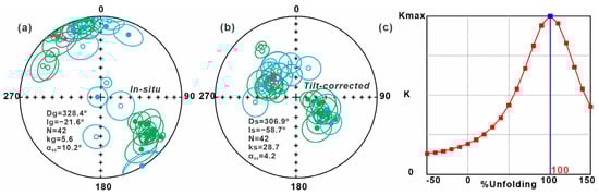
Figure 8.
(a,b) Equal-area projections of the 42 site-mean directions before and after tilt-correction. Paleomagnetic data obtained in this study are shown in blue, alongside published data from [23] in green. (c) Results of stepwise unfolding of the 42 site-mean directions [45]. Red stars indicate the overall mean directions.
For the paleomagnetic data from onshore southwestern Australia and northeastern India, the paleomagnetic pole (BB) indicates that the Bunbury basalts were emplaced at 52.0 ± 4.0° S [28]. However, the Bunbury basalts were assigned a Late Cretaceous age based on the K/Ar dating [53], and later abundant new 40Ar/39Ar dating supported that the Bunbury basalts erupted at ~137–130 Ma [14]. It is worth noting that Ali et al. [29] published a paleomagnetic pole (AB) obtained from the Abor volcanic rocks of the eastern Himalayan Syntaxis. Due to potential within-flow-plane rotations affecting the directional data, Ali et al. [29] suggested a paleolatitude of ~58.1° S calculated by the inclination-only method. The Abor volcanic rocks were initially considered to have erupted during the Permian based on their primary magnetization direction resembling that observed from the Permian rocks [29]. However, recent U–Pb geochronological results confirmed that the Abor volcanic rocks, genetically linked to the KMP, erupted at ~145–132 Ma [13,14]. This southernmost paleolatitude likely defines the southern boundary of the ~147–130 Ma circum-eastern Gondwana LIP.
Collectively, the high-quality paleomagnetic results indicate that the ~147–130 Ma circum-eastern Gondwana LIP had a paleolatitude range from approximately 40.7° S to 58.1° S, with a central paleolatitude of about ~49.4° S. This reconstructed position aligns closely with the present-day latitude of the Kerguelen hotspot (~49.0° S), as deduced from seismic imaging [54].
6.2. The Reconstruction and Breakup of Eastern Gondwana
Prior to the separation of India from eastern Gondwana, it is well established that the eastern TH was situated in proximity to southwestern Australia [5]. Nevertheless, the location of the central TH keeps an open question [8,55,56]. Notably, the submarine Naturaliste Plateau (NP), Wallaby Plateau (WP), and Zenith Plateau (ZP) in southwestern Australia are generally accepted as the crucial boundary of the Indian and Australian plates, and the WP and ZP are connected to the eastern TH [5,8]. This reconstruction (Figure 9), coupled with the consistency in the central paleolatitudes of the LIP and the location of the KMP, indicates that the junction between India and Australia was entirely influenced by the KMP. Previous studies revealed that the orogen lithosphere is considered weaker than the craton, thus they are likely the locations for the manifestation of mantle plumes and the breakup of supercontinents [57]. The interior Kuunga-Pinjarra Orogen between the Australian and Indian plates formed during the assembly of eastern Gondwana [58]. This evidence, combined with our reconstruction, explains the linear distribution pattern of the pre-130 Ma magmatic products.

Figure 9.
The breakup model of eastern Gondwana, created using GPlates [59]. MD, Madagascar; GI, Greater India; ZP, Zenith Plateau; WP, Wallaby Plateau; NP, Naturaliste Plateau; KMP, Kerguelen mantle plume. The magnetic anomaly data (M10, M9o, and M0) are from [8]. The evolution models of the ZP, WP, and ZP are from [8,60].
The arrival of a hot mantle plume at the base of the lithosphere has been predicted to cause a regional uplift, the LIP, and finally continental rifting [61]. According to stratigraphic and geophysical evidence, the uplift has been documented along the northern margin of Greater India (from eastern TH to Nepal) [62] and the entire western margin of Australia [63,64] at the Jurassic–Cretaceous boundary (Figure 9a), followed by subsequent ~147–130 Ma magmatism in these locations, with two peaks at ~141 Ma and ~132 Ma [2,9,10,16,17,21,23]. At ~147 Ma (Figure 9a), the earliest evidence of magmatic activity is recorded in the Lakang Formation within the Comei region of the eastern TH [16]. By ~141 Ma (Figure 9b), the KMP initiated its first major eruptive phase, with magmatic activity extending eastward to the Abor area of India [13,14] and westward to the Zhongba area of the central TH [11,16,23]. A second significant eruptive episode occurred at ~132 Ma [3,4,9,10], which also influenced the Bunbury area in southwestern Australia [2,35]. In addition, the interpretation of the oldest magnetic anomalies between India-Antarctica (M9o, ~130.2 Ma) [7] and India-Australia (M10, ~130.2 Ma) [8] supports that the continental lithosphere was ultimately split at ~130 Ma (Figure 9c). By ~124 Ma (Figure 9d), the latest Early Cretaceous magmatic events associated with the KMP were documented in both the eastern TH [33] and southwestern Australia [65]. This period also marked the onset of the Indian Ocean opening, during which seafloor magnetic anomaly patterns began to record the history of oceanic crustal expansion [8]. These lines of evidence support a typical mantle plume-induced breakup model and indicate that the KMP played an active role in the breakup of eastern Gondwana.
7. Conclusions
We have presented a new paleomagnetic dataset from the Weimei Formation volcanic rocks in the central TH. Our paleomagnetic data satisfy all seven R-score criteria proposed by Meert et al. [47] to appraise the reliability of paleomagnetic data. These new paleomagnetic data, combined with those from the eastern TH, northeastern India, and southwestern Australia, can summarize several conclusions as follows.
- (1)
- The Weimei Formation volcanic rocks of the central TH were emplaced at a paleolatitude of ~39.1° S.
- (2)
- The ~147–130 Ma circum-eastern Gondwana LIP erupted at ~40.7–58.1° S, with a central paleolatitude of about ~49.4° S, which is consistent with the present center of KMP (~49.0° S).
- (3)
- Integrating other evidence, we consider that the Kerguelen mantle plume played a key role in the breakup of eastern Gondwana.
Supplementary Materials
The following supporting information can be downloaded at: https://www.mdpi.com/article/10.3390/min15111224/s1, Table S1: Characteristic remanent magnetization direction of each specimen. Table S2: Site mean directions of the Weimei Formation volcanic rocks from Zhongba county in the central Tethyan Himalaya.
Author Contributions
Conceptualization, X.J. and T.Y.; methodology, X.J. and T.Y.; validation, X.J. and T.Y.; formal analysis, X.J. and T.Y.; investigation, X.J., J.L., T.Y., J.L., Y.Z. (Yabo Zhang) and W.B.; resources, T.Y., W.B., J.D., H.Z., H.L. and H.W.; data curation, X.J.; writing—original draft preparation, X.J.; writing—review and editing, X.J., T.Y., W.B., J.D., H.Z., H.L., H.W., Y.Z. (Yong Zhao) and T.F.; visualization, X.J.; supervision, T.Y.; project administration, T.Y., W.B. and X.J.; funding acquisition, X.J., W.B. and T.Y. All authors have read and agreed to the published version of the manuscript.
Funding
This research was funded by the Open Fund (DGERA20251002) of Key Laboratory of Deep-time Geography and Environment Reconstruction and Applications of Ministry of Natural Resources, Chengdu University of Technology, the Frontiers Science Center for Deep-time Digital Earth, China University of Geosciences (Beijing) (2652023001), State Key Laboratory of Geomicrobiology and Environmental Changes, China University of Geosciences (51830100302), the Fundamental Research Funds for the Central Universities (292021105, 292021106, and 292021107), and the Chinese ‘111’ Project (B20011).
Data Availability Statement
The original contributions presented in this study are included in the article/Supplementary Materials. Further inquiries can be directed to the corresponding author.
Acknowledgments
The author sincerely thanks everyone who helped complete this overview.
Conflicts of Interest
The authors declare no conflicts of interest.
Abbreviations
The following abbreviations are used in this manuscript:
| KMP | Kerguelen mantle plume |
| LIP | Large igneous province |
| TH | Tethyan Himalaya |
| GH | Greater Himalaya |
| LH | Lesser Himalaya |
| SH | Sub-Himalaya |
| ITSZ | Indus-Tsangpo Suture Zone |
| Pl | Plagioclase |
| Px | Pyroxene |
| Chl | Chlorite |
| IRM | Isothermal remanent magnetization |
| AF | Alternating field |
| NP | Naturaliste Plateau |
| WP | Wallaby Plateau |
| ZP | Zenith Plateau |
References
- Torsvik, T.H.; Cocks, L.R.M. Gondwana from top to base in space and time. Gondwana Res. 2013, 24, 999–1030. [Google Scholar] [CrossRef]
- Olierook, H.K.H.; Jiang, Q.; Jourdan, F.; Chiaradia, M. Greater Kerguelen large igneous province reveals no role for Kerguelen mantle plume in the continental breakup of eastern Gondwana. Earth Planet. Sci. Lett. 2019, 511, 244–255. [Google Scholar] [CrossRef]
- Peng, W.; Yang, T.; Shi, Y.; Bian, W.; Ma, Y.; Wang, S.; Jiao, X.; Ma, J.; Kang, Y.; Zhang, S.; et al. Role of the Kerguelen mantle plume in breakup of eastern Gondwana: Evidence from early cretaceous volcanic rocks in the eastern Tethyan Himalaya. Palaeogeogr. Palaeoclimatol. Palaeoecol. 2022, 588, 110823. [Google Scholar] [CrossRef]
- Liang, J.; Bian, W.; Jiao, X.; Peng, W.; Ma, J.; Wang, S.; Ma, Y.; Zhang, S.; Wu, H.; Li, H.; et al. Geochronological results from the Zhela Formation volcanics of the Tethyan Himalaya and their implications for the breakup of eastern Gondwana. Sci. Rep. 2023, 13, 110823. [Google Scholar] [CrossRef] [PubMed]
- Ali, J.R.; Aitchison, J.C. Greater India. Earth-Sci. Rev. 2005, 72, 169–188. [Google Scholar] [CrossRef]
- Jadoul, F.; Berra, F.; Garzanti, E. The Tethys Himalayan passive margin from late Triassic to early Cretaceous (south Tibet). J. Asian Earth Sci. 1998, 6, 173–194. [Google Scholar] [CrossRef]
- Gaina, C.; Müller, R.D.; Brown, B.; Ishihara, T.; Ivanov, S. Breakup and early seafloor spreading between India and Antarctica. Geophys. J. Int. 2007, 170, 151–169. [Google Scholar] [CrossRef]
- Gibbons, A.D.; Barckhausen, U.; van den Bogaard, P.; Hoernle, K.; Werner, R.; Whittaker, J.M.; Müller, R.D. Constraining the Jurassic extent of Greater India: Tectonic evolution of the West Australian margin. Geochem. Geophys. Geosyst. 2012, 13, Q05W13. [Google Scholar] [CrossRef]
- Zhu, D.; Chung, S.; Mo, X.; Zhao, Z.; Niu, Y.; Song, B.; Yang, Y. The 132 Ma Comei-Bunbury large igneous province: Remnants identified in present-day southeastern Tibet and southwestern Australia. Geology 2009, 37, 583–586. [Google Scholar] [CrossRef]
- Chen, S.; Fan, W.; Shi, R.; Xu, J.; Liu, Y. The Tethyan Himalaya Igneous Province: Early Melting Products of the Kerguelen Mantle Plume. J. Petrol. 2021, 62, egab069. [Google Scholar] [CrossRef]
- Yang, K.; Dai, J.; Shen, J.; Jia, X. Episodic continental extension in eastern Gondwana during the mid-late Mesozoic: Insights from geochronology and geochemistry of mafic rocks in the Tethyan Himalaya. Int. Geol. Rev. 2022, 65, 278–295. [Google Scholar] [CrossRef]
- Zhou, Q.; Liu, Z.; Wang, S.; Lai, Y.; Wang, G.; Liao, Z.; Li, Y.; Wu, J.; Wang, S.; Qing, C. Petrogenesis of mafic and felsic rocks from the Comei large igneous province, South Tibet: Implications for the initial activity of the Kergue. Geol. Soc. Am. 2018, 130, 811–824. [Google Scholar] [CrossRef]
- Oinam, G.; Singh, A.K.; Dutt, A.; Khogenkumar, S.; Joshi, M.; Singhal, S.; Bikramaditya, R.K. Magmatic records of Gondwana assembly and break-up in the eastern Himalayan syntaxis, northeast India. Gondwana Res. 2022, 112, 126–146. [Google Scholar] [CrossRef]
- Singh, A.K.; Chung, S.L.; Bikramaditya, R.; Lee, H.Y.; Khogenkumar, S.; Lancaster, P. Zircon U-Pb geochronology, Hf isotopic compositions, and petrogenetic study of Abor volcanic rocks of Eastern Himalayan Syntaxis, Northeast India: Implications for eruption during breakup of Eastern Gondwana. Geol. J. 2019, 55, 1227–1244. [Google Scholar] [CrossRef]
- Olierook, H.K.H.; Jourdan, F.; Merle, R.E.; Timms, N.E.; Kusznir, N.; Muhling, J.R. Bunbury Basalt: Gondwana breakup products or earliest vestiges of the Kerguelen mantle plume? Earth Planet. Sci. Lett. 2016, 440, 20–32. [Google Scholar] [CrossRef]
- Shi, Y.; Hou, C.; Anderson, J.L.; Yang, T.; Ma, Y.; Bian, W.; Jin, J. Zircon SHRIMP U–Pb age of Late Jurassic OIB-type volcanic rocks from the Tethyan Himalaya: Constraints on the initial activity time of the Kerguelen mantle plume. Acta Geochim. 2017, 37, 441–455. [Google Scholar] [CrossRef]
- Zhang, Z.; Li, G.; He, X.; Zhang, L.; Dong, S.; Qing, C.; Liang, W.; Han, S. The evolution of Kerguelen mantle plume and breakup of eastern Gondwana: New insights from multistage Cretaceous magmatism in the Tethyan Himalaya. Gondwana Res. 2023, 119, 68–85. [Google Scholar] [CrossRef]
- Liu, Z.; Zhou, Q.; Lai, Y.; Qing, C.; Li, Y.; Wu, J.; Xia, X. Petrogenesis of the Early Cretaceous Laguila bimodal intrusive rocks from the Tethyan Himalaya: Implications for the break-up of Eastern Gondwana. Lithos 2015, 236, 190–202. [Google Scholar] [CrossRef]
- Zeng, Y.; Xu, J.; Chen, J.; Wang, B.; Huang, F.; Yu, H.; Chen, X.; Zhao, P. Breakup of Eastern Gondwana as inferred from the Lower Cretaceous Charong Dolerites in the central Tethyan Himalaya, southern Tibet. Palaeogeogr. Palaeoclimatol. Palaeoecol. 2019, 515, 70–82. [Google Scholar] [CrossRef]
- Frey, F.A.; McNaughton, N.J.; Nelson, D.R.; deLaeter, J.R.; Duncan, R.A. Petrogenesis of the Bunbury Basalt, Western Australia: Interaction between the Kerguelen plume and Gondwana lithosphere? Earth Planet. Sci. Lett. 1996, 144, 163–183. [Google Scholar] [CrossRef]
- Wei, Y.; Liang, W.; Shang, Y.; Zhang, B.; Pan, W. Petrogenesis and tectonic implications of ∼130 Ma diabase dikes in the western Tethyan Himalaya (western Tibet). J. Asian Earth Sci. 2017, 143, 236–248. [Google Scholar] [CrossRef]
- Lian, D.; Liu, F.; Yang, J.; Xu, Z.; Wu, W. Fingerprints of the Kerguelen Mantle Plume in Southern Tibet: Evidence from Early Cretaceous Magmatism in the Tethyan Himalaya. J. Geol. 2021, 129, 207–231. [Google Scholar] [CrossRef]
- Jiao, X.; Yang, T.; Bian, W.; Wang, S.; Peng, W.; Ma, J.; Ding, J.; Liang, J.; Zhang, Y.; Li, H.; et al. First Paleomagnetic and Geochronological Results From the Early Cretaceous Volcanic Rocks in the Western Tethyan Himalaya: Contribution to the Breakup of Eastern Gondwana and the Paleogeography of Neo-Tethys Ocean. J. Geophys. Res. Solid Earth 2025, 130, e2024JB031095. [Google Scholar] [CrossRef]
- Peng, W. Multi-Stage of Early Cretaceous Mafic Magmatism in the Tethyan Himalaya: Implications for the Breakup of Eastern Gondwana; China University of Geoscience: Beijing, China, 2024. [Google Scholar]
- Metcalfe, I. Gondwana dispersion and Asian accretion: Tectonic and palaeogeographic evolution of eastern Tethys. J. Asian Earth Sci. 2013, 66, 1–33. [Google Scholar] [CrossRef]
- Yin, A.; Harrison, T.M. Geologic evolution of the Himalayan Tibetan orogen. Annu. Rev. Earth Planet. Sci. 2000, 28, 211–280. [Google Scholar] [CrossRef]
- Bian, W.; Yang, T.; Ma, Y.; Jin, J.; Gao, F.; Wang, S.; Peng, W.; Zhang, S.; Wu, H.; Li, H.; et al. Paleomagnetic and Geochronological Results From the Zhela and Weimei Formations Lava Flows of the Eastern Tethyan Himalaya: New Insights Into the Breakup of Eastern Gondwana. J. Geophys. Res. Solid Earth 2019, 124, 44–64. [Google Scholar] [CrossRef]
- Schmidt, P.W. A new palaeomagnetic investigation of Mesozoic igneous rocks in Australia. Teconophysics 1976, 33, 1–13. [Google Scholar] [CrossRef]
- Ali, J.R.; Aitchison, J.C.; Chik, S.Y.S.; Baxter, A.T.; Bryan, S.E. Paleomagnetic data support Early Permian age for the Abor Volcanics in the lower Siang Valley, NE India: Significance for Gondwana-related break-up models. J. Asian Earth Sci. 2012, 50, 105–115. [Google Scholar] [CrossRef]
- Bian, W.; Yang, T.; Deng, J.; Ma, Y.; Peng, W.; Wang, S.; Jiao, X.; Ma, J.; Liang, J.; Jin, J.; et al. Paleomagnetic constraints on the link between the Comei-Bunbury large igneous province and the Kerguelen mantle plume. Gondwana Res. 2024, 134, 30–47. [Google Scholar] [CrossRef]
- Yang, T.; Ma, Y.; Bian, W.; Jin, J.; Zhang, S.; Wu, H.; Li, H.; Yang, Z.; Ding, J. Paleomagnetic results from the Early Cretaceous Lakang Formation lavas: Constraints on the paleolatitude of the Tethyan Himalaya and the India–Asia collision. Earth Planet. Sci. Lett. 2015, 428, 120–133. [Google Scholar] [CrossRef]
- Zhu, D.; Mo, X.; Pan, G.; Zhao, Z.; Dong, G.; Shi, Y.; Liao, Z.; Wang, L.; Zhou, C. Petrogenesis of the earliest Early Cretaceous mafic rocks from the Cona area of the eastern Tethyan Himalaya in south Tibet: Interaction between the incubating Kerguelen plume and the eastern Greater India lithosphere? Lithos 2008, 100, 147–173. [Google Scholar] [CrossRef]
- Ma, Y.; Yang, T.; Bian, W.; Jin, J.; Zhang, S.; Wu, H.; Li, H. Early Cretaceous paleomagnetic and geochronologic results from the Tethyan Himalaya: Insights into the Neotethyan paleogeography and the India-Asia collision. Sci. Rep. 2016, 6, 21605. [Google Scholar] [CrossRef] [PubMed]
- Tian, Y.; Gong, J.; Chen, H.; Guo, L.; Xu, Q.; Chen, L.; Lin, X.; Cheng, X.; Yang, R.; Zhao, L.; et al. Early Cretaceous bimodal magmatism in the eastern Tethyan Himalayas, Tibet: Indicative of records on precursory continental rifting and initial breakup of eastern Gondwana. Lithos 2019, 324, 699–715. [Google Scholar] [CrossRef]
- Direen, N.G.; Cohen, B.E.; Maas, R.; Frey, F.A.; Whittaker, J.M.; Coffin, M.F.; Meffre, S.; Halpin, J.A.; Crawford, A.J. Naturaliste Plateau: Constraints on the timing and evolution of the Kerguelen Large Igneous Province and its role in Gondwana breakup. Aust. J. Earth Sci. 2017, 64, 851–869. [Google Scholar] [CrossRef]
- Yin, A. Cenozoic tectonic evolution of the Himalayan orogen as constrained by along-strike variation of structural geometry, exhumation history, and foreland sedimentation. Earth-Sci. Rev. 2006, 76, 1–131. [Google Scholar] [CrossRef]
- Du, X.; Chen, X.; Wang, C.; Wei, Y.; Li, Y.; Jansa, L. Geochemistry and detrital zircon U–Pb dating of Lower Cretaceous volcaniclastics in the Babazhadong section, Northern Tethyan Himalaya: Implications for the breakup of Eastern Gondwana. Cretac. Res. 2015, 52, 127–137. [Google Scholar] [CrossRef]
- Kirschvink, J.L. The least-squares line and plane and the analysis of palaeomagnetic data. Geophys. J. Int. 1980, 62, 699–718. [Google Scholar] [CrossRef]
- Fisher, R.A. Dispersion on a sphere. Philos. Trans. R. Soc. A Math. Phys. Eng. Sci. 1953, 217, 295–305. [Google Scholar] [CrossRef]
- Butler, R.F. Paleomagnetism: Magnetic Domains to Geologic Terranes; Blackwell Scientific Publications: Oxford, UK, 1992. [Google Scholar]
- Pang, K.N.; Zhou, M.F.; Lindsley, D.; Zhao, D.; Malpas, J. Origin of Fe–Ti Oxide Ores in Mafic Intrusions: Evidence from the Panzhihua Intrusion, SW China. J. Petrol. 2008, 49, 295–313. [Google Scholar] [CrossRef]
- Maxbauer, D.; Feinberg, J.; Fox, D. A web application for unmixing magnetic coercivity. Comput. Geosci. 2016, 95, 140–145. [Google Scholar] [CrossRef]
- McElhinny, M.W. Statistical Significance of the Fold Test in Palaeomagnetism. Geophys. J. Int. 1964, 8, 338–340. [Google Scholar] [CrossRef]
- McFadden, P.L. A new fold test for palaeomagnetic studies. Geophys. J. Int. 1990, 103, 163–169. [Google Scholar] [CrossRef]
- Watson, G.S.; Enkin, R.J. The fold Test in paleomagnetism as a parameter estimation problem. Geophys. Res. Lett. 1993, 20, 2135–3137. [Google Scholar] [CrossRef]
- Deenen, M.H.L.; Langereis, C.G.; Hinsbergen, D.J.J.v.; Biggin, A.J. Geomagnetic secular variation and the statistics of paleomagnetic directions. Geophys. J. Int. 2011, 186, 509–520. [Google Scholar] [CrossRef]
- Meert, J.G.; Pivarunas, A.F.; Evans, D.A.D.; Pisarevsky, S.A.; Pesonen, L.J.; Li, Z.; Elming, S.-Å.; Miller, S.R.; Zhang, S.; Salminen, J.M. The magnificent seven: A proposal for modest revision of the quality index. Tectonophysics 2020, 790, 228549. [Google Scholar] [CrossRef]
- Zhang, Y.; Huang, B.; Zhao, Q. New paleomagnetic positive proof of the rigid or quasi-rigid Greater Indian plate during the Early Cretaceous. Chin. Sci. Bull. 2019, 64, 2225–2244. (In Chinese) [Google Scholar] [CrossRef]
- Hou, C. Zircon SHRIMP U-Pb Age and Geochemistry of the Lakang Formation Volcanic Rocks in Tethyan Himalaya. Master’s Thesis, China University of Geoscience, Beijing, China, 2017. (In Chinese). [Google Scholar]
- Mardia, K.V.; Gadsden, R.J. A Small Circle of Best Fit for Spherical Data and Areas of Vulcanism. Appl. Stat. 1977, 26, 238–245. [Google Scholar] [CrossRef]
- McFadden, P.L.; McElhinny, M.W. Classification of the reversal test in palaeomagnetism. Geophys. J. Int. 1990, 103, 725–729. [Google Scholar] [CrossRef]
- Tauxe, L.; Kent, D.V. A Simplified Statistical Model for the Geomagnetic Field and the Detection of Shallow Bias in Paleomagnetic Inclinations: Was the Ancient Magnetic Field Dipolar? In Timescales of The Paleomagnetic Field; Channell, J.E.T., Kent, D.V., Lowrie, W., Meert, J.G., Eds.; AGU: Washington, DC, USA, 2004. [Google Scholar] [CrossRef]
- McDougall, I.; Wellman, P. Potassium-argon ages for some Australian Mesozoic igneous rocks. J. Geol. Soc. Aust. 1976, 23, 1–9. [Google Scholar] [CrossRef]
- Zhao, D. Seismic images under 60 hotspots: Search for mantle plumes. Gondwana Res. 2007, 12, 335–355. [Google Scholar] [CrossRef]
- Ali, J.R.; Aitchison, J.C. Greater India’s northern margin prior to its collision with Asia. Basin Res. 2014, 26, 73–84. [Google Scholar] [CrossRef]
- Meng, J.; Gilder, S.A.; Wang, C.; Coe, R.S.; Tan, X.; Zhao, X.; He, K. Defining the Limits of Greater India. Geophys. Res. Lett. 2019, 46, 4182–4191. [Google Scholar] [CrossRef]
- Dang, Z.; Zhang, N.; Li, Z.X.; Huang, C.; Spencer, C.J.; Liu, Y. Weak orogenic lithosphere guides the pattern of plume-triggered supercontinent break-up. Commun. Earth Environ. 2020, 1, 51. [Google Scholar] [CrossRef]
- Cawood, P.A.; Martin, E.L.; Murphy, J.B.; Pisarevsky, S.A. Gondwana’s interlinked peripheral orogens. Earth Planet. Sci. Lett. 2021, 568, 117057. [Google Scholar] [CrossRef]
- Müller, R.D.; Cannon, J.; Qin, X.; Watson, R.J.; Gurnis, M.; Williams, S.; Pfaffelmoser, T.; Seton, M.; Russell, S.H.J.; Zahirovic, S. GPlates: Building a Virtual Earth Through Deep Time. Geochem. Geophys. Geosyst. 2018, 19, 2243–2261. [Google Scholar] [CrossRef]
- Williams, S.E.; Whittaker, J.M.; Granot, R.; Müller, D.R. Early India-Australia spreading history revealed by newly detected Mesozoic magnetic anomalies in the Perth Abyssal Plain. J. Geophys. Res. Solid Earth 2013, 118, 3275–3284. [Google Scholar] [CrossRef]
- Anderson, D.L. Hotspots, polar wander, Mesozoic convection and the geoid. Nature 1982, 297, 391–393. [Google Scholar] [CrossRef]
- Sciunnach, D.; Garzanti, E. Subsidence history of the Tethys Himalaya. Earth-Sci. Rev. 2012, 111, 179–198. [Google Scholar] [CrossRef]
- Heine, C.; Müller, R.D. Late Jurassic rifting along the Australian North West Shelf: Margin geometry and spreading ridge configuration. Aust. J. Earth Sci. 2005, 52, 27–39. [Google Scholar] [CrossRef]
- Maloney, D.; Sargent, C.; Direen, N.G.; Hobbs, R.W.; Gröcke, D.R. Re-evaluation of the Mentelle Basin, a polyphase rifted margin basin, offshore southwest Australia: New insights from integrated regional seismic datasets. Solid Earth 2011, 2, 107–123. [Google Scholar] [CrossRef]
- Olierook, H.K.H.; Merle, R.E.; Jourdan, F.; Sircombe, K.; Fraser, G.; Timms, N.E.; Nelson, G.; Dadd, K.A.; Kellerson, L.; Borissova, I. Age and geochemistry of magmatism on the oceanic Wallaby Plateau and implications for the opening of the Indian Ocean. Geology 2015, 43, 971–974. [Google Scholar] [CrossRef]
Disclaimer/Publisher’s Note: The statements, opinions and data contained in all publications are solely those of the individual author(s) and contributor(s) and not of MDPI and/or the editor(s). MDPI and/or the editor(s) disclaim responsibility for any injury to people or property resulting from any ideas, methods, instructions or products referred to in the content. |
© 2025 by the authors. Licensee MDPI, Basel, Switzerland. This article is an open access article distributed under the terms and conditions of the Creative Commons Attribution (CC BY) license (https://creativecommons.org/licenses/by/4.0/).