Abstract
An unprecedented land conservation effort is presently underway in the Gulf of Mexico Coastal Region (GCR) due to an influx of funds from settlements related to the 2012 RESTORE Act. A complete understanding of the priorities of the states in the GCR is critical to ensure that land conservation planning efforts are implemented effectively and efficiently. The paper reviews past, current, and future land conservation priorities in the GCR to inform strategic planning efforts. This review catalogs an extensive list of projects and plans proposed and implemented at federal, state, county, and city levels with direct ties to land conservation during the past 20 years. Comprehensive restoration goals proposed by the Gulf Coast Ecosystem Restoration (Restore) Council were used as a framework for grouping priorities within conservation plans and projects. Plans were first compiled via internet searches and expert sources, then a series of eight stakeholder charrettes were held across the GCR states to validate the catalog and add missing projects and plans. A geospatial web tool was developed using the Restore Council goal framework to allow for the identification and exploration of plans in the GCR.
1. Introduction
The United States (US) Gulf of Mexico Coastal Region (GCR) contains a vast and diverse natural landscape, which includes coastal wetlands, submerged vegetation, bayous, uplands, and offshore marine areas (Figure 1). Encompassing more than 700,000 square km, the GCR harbors over 15,000 species of flora and fauna [1]. This biodiversity is a product of the breadth of ecosystems represented within the GCR landscape. The five adjoining states in the GCR, including parts of Alabama (AL), Florida (FL), Louisiana (LA), Mississippi (MS), and Texas (TX), are also places of rich culture and great natural beauty, with deep socioeconomic ties to the abundant natural resources in the region. Since natural and societal values depend on the ecological richness of the region, conservation is a shared priority among many GCR stakeholders. However, years of ecological degradation [2,3,4,5], including the effects of the 2010 Deepwater Horizon disaster and oil spill, have increased the vulnerability of resources within the region.
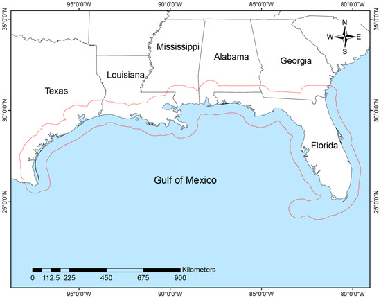
Figure 1.
Overview of the Gulf of Mexico Coastal Region (GCR) along the U.S. Gulf of Mexico. The GCR includes all of the coastal counties, plus 40.2 km inland of the coast including the barrier islands as shown in red outline.
The US has a long history of practicing land conservation at all levels of government resulting in a robust network of protected lands in the GCR [6]. However, a persistent conservation planning challenge is the identification of optimal lands in need of protection and subsequent prioritization of those areas based on ecological and socioeconomic valuations. As it is not possible to protect all the land worth protecting within a region at the same time, a strategic approach must be used to identify the most effective lands to conserve relative to ecological and socioeconomic goals [7]. However, substantial lands remain vulnerable to conversion, and, to date, there is a lack of comprehensive analysis of land conservation planning efforts across the entire GCR geography to improve strategic targeting of land conservation efforts. A holistic understanding of the extent and focuses of existing conservation efforts in the GCR will help planners direct appropriate conservation actions in the future. With private land ownership dominating over 86% of agricultural and forested lands in the GCR, conservation and management decisions involving private landowners has a significant impact on the region’s environment and economy [8]. Proactive engagement with state and federal agencies, private landowners, local communities, and nonprofit organizations that actively conserve land via joint agreements with landowners, direct land purchases, and other methods will be paramount to create a sustainable future for the GCR.
In response to the Deepwater Horizon oil spill of 2010, the US government acted in concert with states to implement coordinated efforts to restore the ecosystems and economy of the GCR. Included in the federal response is the Resources and Ecosystems Sustainability, Tourist Opportunities, and Revived Economies of the Gulf Coast States (RESTORE) Act, signed into law in July 2012 [9]. The RESTORE Act created the Gulf Coast Ecosystem Restoration Council (Council) and the Gulf Coast Restoration Trust Fund (Trust Fund). The RESTORE Council consists of 11 members, including leaders of six federal departments and governors of the five Gulf Coast states. One of the Council’s responsibilities is the development of a comprehensive plan for the restoration of the Gulf Coast. The Trust Fund is responsible for obligating 80 percent of the Clean Water Act penalties generated from the oil spill with the funds going towards accomplishing goals and objectives identified in the RESTORE Council’s comprehensive plan [10]. These goals include Restore and Conserve Habitat (Habitat), Restore Water Quality (Water Quality), Replenish and Protect Living Coastal and Marine Resources (LCMR), Enhance Community Resilience (Community Resilience), and Restore and Revitalize the Gulf Economy (Gulf Economy). For clarity, we will hereafter refer to each RESTORE goal in the text as they appear in parenthesis in the previous sentence. The Strategic Conservation Assessment (SCA) project, funded by the Department of Interior (DOI) via the Council Selected Restoration Component, is focused on developing science-based conservation planning support tools using the RESTORE goal framework to maximize the effectiveness of land conservation investments. In this work, one of these tools is presented that catalogs existing conservation plans in the form of geospatial visualization.
A holistic understanding of the origin of conservation plans and their relationship with respect to RESTORE conservation goals can be useful in understanding and aligning conservation planning efforts to funding opportunities associated with land conservation in the GCR. Similar comprehensive analyses of conservation effort have been conducted in Australia and Europe [11,12]. The outcomes of such research found an uneven representation of habitat protections across their respective regions and characterized the frequency of conservation at different planning extents. While our study has a similar vein of analysis, it is distinguished by our characterization of conservation efforts within the framework of the RESTORE goals which represent the shared priorities of the GCR. We focus on the RESTORE goals framework because of the unique opportunity to fund conservation efforts from the influx of funds from settlements related to the 2012 RESTORE Act. The product of this study will thus summarize how land conservation across the GCR has addressed the RESTORE goals, with the intent that it will help illuminate and guide appropriate conservation actions that provide adequate protections for the region’s diverse landscape, species, and economic activity.
In this study, we compiled and reviewed an extensive inventory of conservation plans in the Gulf of Mexico—from local to regional (i.e., GCR) levels—to catalog priorities identified and efforts undertaken with respect to land conservation. With respect to RESTORE goals, we expect plans to more frequently address Habitat, Water Quality and LCMR. Whereas socioeconomic goals such as Community Resilience and Gulf Economy are not typically addressed through land conservation, we therefore expect these goals to occur less frequently. This study is the first large-scale regional assessment of conservation planning efforts across governmental, nongovernmental, and nonprofit organizations encompassing all ecosystem types in the GCR. This comprehensive analysis is vital to understanding the key factors that may drive existing conservation efforts, as well as identify potential gaps in conservation planning efforts.
The contributions of this study include
- a catalog of conservation plans and projects in the GCR at multiple levels of the jurisdiction from 1998 to 2018;
- the development of an online geospatial tool for exploring conservation plans in the GCR; and
- an assessment of how conservation planning at various political and geomorphological subregions within the GCR associates with the RESTORE Council goals.
2. Materials and Methods
2.1. Scope of the Study
The SCA region of interest aligns with the RESTORE Act-identified GCR, an area of approximately 700,000 square km (Figure 1). The GCR encompasses coastal parts of AL, LA, MS, TX, and all of FL. This geographic extent was created using the coastal management zone area in the five Gulf states, plus a 40.2 km inland buffer. Some of the plans within the catalog extended outside these limits but were included if benefits directly occurred within the SCA region.
2.2. Method for Cataloging Plans
To represent the breadth of planning scales, the conservation plans were categorized in three ways: by (1) individual states in the GCR; (2) political and geomorphological subregions (Table 1); and (3) the goals identified by the RESTORE Council (Table 2). Some plans extended beyond an individual state and were grouped as GCR plans in lieu of belonging to an individual state. The plans were also grouped by political and geomorphological subregions because of the importance of planning scale towards achieving conservation objectives. Plans with political boundary classifications (i.e., city, county/parish, region (within the state), statewide, and GCR), were developed by the representative political entity and incorporated some land conservation actions. Regional plans had focal areas of two or more cities or counties/parishes within a state and GCR plans had planning scales that spanned multiple states within the GCR. Geomorphological classification scales included coastal habitat for plans with focal areas such as barrier islands, estuaries, and other areas within the coastal zone (e.g., beaches, dunes, and salt marshes), and basin/watershed for plans which used watersheds as planning scales.

Table 1.
Political and geomorphological subregions (subregions) considered in the assessment of Gulf Coast plans.
Table 2.
Goals identified in the Gulf Coast Ecosystem Restoration Council [10].
For purposes of this work, we define land conservation as strategic investments in land acquisitions, easements, and stewardship for conservation and/or preservation purposes to protect ecological and socioeconomic values in the GCR. We define acquisition as land acquired from a willing seller who enters into a purchase agreement and sells the title of a property to a land trust or government (i.e., fee title or fee simple). In contrast, easement limits specific uses of the land to achieve specific conservation objectives while keeping the land in the owner’s control. Stewardship is a general term for land management, restoration, and maintenance of lands specifically applied here to fee title acquisitions and conservation easements on private lands.
The RESTORE Council distinguished five goals in their comprehensive plan (Table 2) as a framework for helping to restore the ecosystem and economy of the GCR [10]. For purposes of the SCA project we defined goals as desired ecological and socioeconomic outcomes that can be achieved through land conservation. Priorities are components of a single goal that focus on a specific aspect in achieving the goal. Plans are documents compiled by various organizations or government agencies that outline land conservation actions. Projects are plans that are funded for implementation or already implemented. Conservation targets are areas of land that are of interest for land conservation. The vast majority of identified “conservation targets” are formalized in existing plans and databases.
Classifying land conservation plans based on the values or benefits they provide with respect to RESTORE goals bestows conservation planners with an important understanding of conservation efforts within a region. In this work, the conservation plans within the GCR were classified into five groups that reflect the RESTORE goals (Table 2). These goals provide the framework for an integrated restoration approach at local, state, tribal and federal levels.
The conservation community along the GCR represents a diverse set of stakeholders with wide-ranging interests, priorities, and objectives. In this work, the established conservation targets were identified through the Gulf of Mexico Alliance (GOMA), Landscape Conservation Cooperatives (LCCs), Migratory Bird Joint Ventures (JVs), State Wildlife Action Plans (SWAPs), the Partnership for Gulf Coast Land Conservation (PGCLC), National Estuary Programs (NEPs), and many others to forgo the “priority resource setting” process that so often bogs down similar efforts [13,14]. To collate these priorities, the SCA project team mined available plans and databases and classified priorities and objectives contained therein by a variety of scales and levels (Table 1 and Table 2). This assessment was intended to be extensive, but not exhaustive, as only the primary considerations for conservation needed to be captured for prioritizing the landscape. Cataloging the priorities and objectives in this way enables stakeholders to identify scale mismatches, scale pluralities, and scale omissions that left unresolved would ultimately undermine any overarching effort to unify these individual plans and designs.
Within the study area, an extensive list was created of existing and proposed conservation plans and projects between 1998 and 2018 (see Appendix A). Each plan underwent an initial review which was used to identify the geographic extent of the plan, the conservation strategies (i.e., acquisition, stewardship, and easement) included in the plan, and the RESTORE goal(s) to which the plan is associated (Table 2). To reduce subjectivity, a second reviewer independently recorded the same information for cross-validation. A plan’s review was considered complete if the two reviews were identical. Otherwise, a third reviewer was used to settle differences. Only plans that addressed at least one conservation strategy as part of the plan content were included in the final inventory.
From March to May 2018, the SCA project team held charrettes with stakeholders across the GCR to discuss the inventory of plans and conservation priorities and identify other priorities for land conservation within the framework of the RESTORE goals. Stakeholders in attendance were representatives from various RESTORE member and partner agencies, and organizations that engage in conservation actions. A total of eight charrettes were conducted within the GCR (Austin, Corpus Christi, and Galveston, Texas; New Orleans, Louisiana; Biloxi, Mississippi; Mobile, Alabama; St. Mark’s and St. Petersburg, Florida) where 176 stakeholders worked with the SCA project team to (1) review and discuss priorities that land conservation strategies can address; (2) develop a weighted list of shared priorities; (3) brainstorm a list of measures for each of the priorities; (4) rank the five RESTORE goals with respect to land conservation strategies; and (5) verify the data catalog and report missing plans/projects.
2.3. Online Catalog of Conservation Plans
The dispersed nature and a lack of single portal access make it difficult for people to effectively and efficiently discover and learn about conservation plans in the GCR. Conservation researchers and organizations often have trouble finding these plans due to the distributed nature of the websites that host them. As users increasingly prefer to take advantage of geospatial data visualization methodologies, an online web portal was developed to organize plans that were analyzed in this work (Figure 2). The catalog was published online as a geospatial web tool, which can be accessed at http://bit.ly/sca_gulf, which will serve as an aggregate of plans and projects in the GCR. This portal also allows users to report missing plans. Since the tool was launched in December 2017, it has been accessed 368 times.
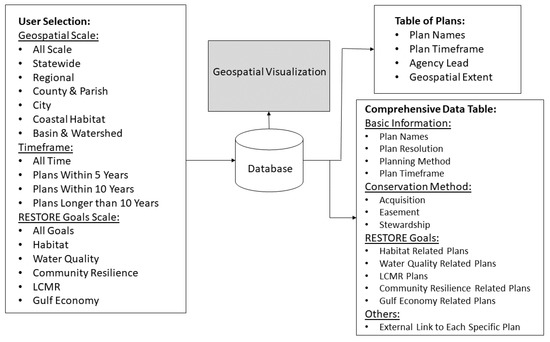
Figure 2.
The site map of the geospatial online visualization tool and catalog detailing the structure, high-level functionality, user options, and navigation scheme.
2.4. Summary of Data
The catalog of plans was summarized by the state of origin, by political and geomorphological subregions (Table 1), and by political and geomorphological subscales within each state, to compare how conservation plans associated with RESTORE goals (Table 2) at each geo-extent. How each geo-extent of conservation planning associates with RESTORE goals was measured by the percentage of plans at each geo-extent that contain objectives that are associated with a particular RESTORE goal. In total, three summaries of conservation plans were made (i.e., by state, by political and geomorphological subscales, and by political and geomorphological subscales within each state) from the catalog that describes the percentage of plans that align with each RESTORE goal. The results of these summaries were then used to understand how consistently RESTORE Goals are addressed by conservation planning throughout the GCR.
3. Conservation Plan Analysis
3.1. RESTORE Goals by State
We gathered 352 plans from communities, NGOs, and state and federal agencies for our initial efforts, and found 293 of those that included some form of land conservation (i.e., acquisition, easement, and stewardship). From the catalog of plans, the majority from each state include LCMR (65–77%) as well as Habitat (53–92%) as conservation priorities (Figure 3). Overall, the minority of plans focus on enhancing community resilience or revitalizing the Gulf economy, with LA-based plans addressing these goals at the highest rate (47% and 43%, respectively). Water quality is addressed in conservation planning at varying rates depending on the state. The majority of FL and LA plans (82% and 57%, respectively) consider water quality conservation targets, while the minority of plans from other states and gulf-wide plans address this goal.
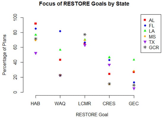
Figure 3.
The focus of conservation plans in states spanning entire GCR categorized into the goals of assessment.
3.2. RESTORE Goals by Subregion
The percentage of plan focus on each RESTORE goal was dependent on political/geomorphological subregion (Figure 4), with the exception of LCMR and Gulf Economy. Across all subregions, LCMR was incorporated as a conservation priority by the majority of plans (60–80%), while Gulf Economy was prioritized by the minority of plans (15–38%). Only 20% of city-level conservation plans focused on Habitat, whereas the majority of plans from all other subregions included the Habitat goal. While Water Quality was a focus of nearly 100% of Basin-Watershed plans, plans from other subregions included Water Quality only 19–59% of the time. The majority of City and County/Parish conservation plans included Community Resilience as a priority, while other subregions prioritized Community Resilience 17–35%.
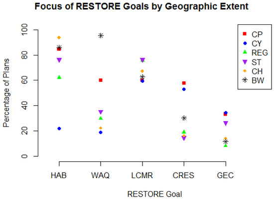
Figure 4.
The focus of conservation plans in the Gulf of Mexico coastal states and entire GCR with respect to CH, BW, CP, CY, REG, and ST. Focus is categorized into the goals of assessment described in Section 2.3.
3.3. RESTORE Goals by State and Subregion
Of the 293 plans, 37 came from AL, 60 from FL, 30 from LA, 57 from MS, 56 from TX, and 53 from the GCR (more than one state). With respect to RESTORE goals, we identified that the majority of plans cataloged in AL focus on Habitat, Water Quality, and LCMR (Figure 5). County/parish and state-level plans in AL contained disproportionately greater priorities related to the Habitat goal relative to other goals. Regional plans focused with greater emphasis on priorities reflecting LCMR goals, whereas basin-wide priorities were the only spatial unit that incorporated elements of Water Quality over priorities in other goals.
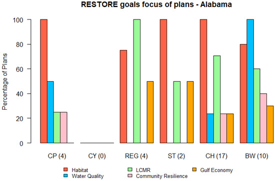
Figure 5.
The focus of conservation plans in the state of Alabama with respect to CH, BW, CP, CY, REG, and ST. Focus is categorized into the goals of assessment described in Section 2.3.
In the state of Florida, we gathered 60 plans that are focused all or in part on some form of land conservation. With respect to RESTORE goals, we identified the majority of plans focus on Habitat, Water Quality, and LCMR, with some emphasis on Community Resilience at the regional and county/parish-level (Figure 6). Coastal habitat, basin and watershed, and county/parish plans contain priorities aligned with Habitat and Water Quality, whereas regional and state-level priorities also emphasize LCMR goals. Gulf Economy was not a substantial priority among FL plans overall, though economic priorities were found in over half of state-wide plans and a quarter of county/parish plans.
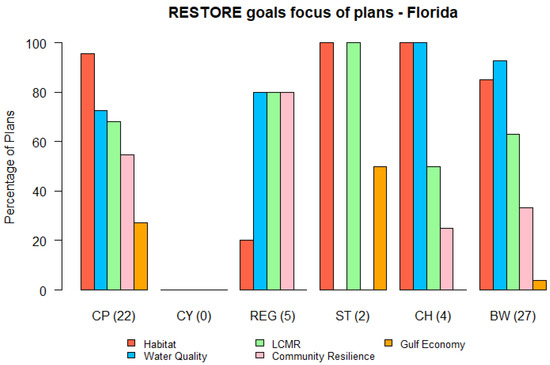
Figure 6.
The focus of conservation plans in the state of Florida with respect to CH, BW, CP, CY, REG, and ST. Focus is categorized into the goals of assessment described in Section 2.3.
In the state of Louisiana, we gathered 30 plans that are focused on some form of land conservation. With respect to RESTORE goals, we identified the majority of plans focus on Habitat, LCMR, Community Resilience, and Water Quality. Basin and watershed and county/parish plans are more aligned in Habitat and Water Quality, though county and parish-level plans prioritize Community Resilience and Gulf Economy over other goal categories (Figure 7). Priorities aligning with LCMR were also found in the majority of state and coastal habitat plans, but also in county/parish-level as well as basin and watershed plans.
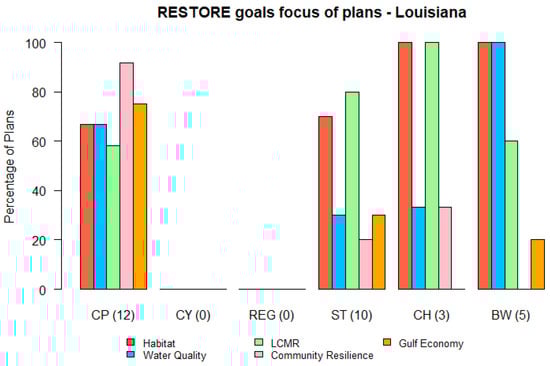
Figure 7.
The focus of conservation plans in the state of Louisiana with respect to CH, BW, CP, CY, REG, and ST. Focus is categorized into the goals of assessment described in Section 2.3.
In the state of Mississippi, we gathered 57 plans that are focused on some form of land conservation. With respect to RESTORE goals, we identified the majority of plans focus on Habitat, Community Resilience, and LCMR (Figure 8). Note that MS had the greatest prevalence of plans that established priorities aligning with Community Resilience across planning scales compared to the remaining states. On the other hand, Water Quality and Gulf Economy priorities were not in the majority across any planning scale.
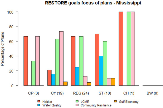
Figure 8.
The focus of conservation plans in the state of Mississippi with respect to CH, BW, CP, CY, REG, and ST. Focus is categorized into the goals of assessment described in Section 2.3.
In the state of Texas, we gathered 56 plans that focused on some form of land conservation. With respect to RESTORE goals, we identified the majority of plans focus on Habitat, LCMR, and Water Quality, though Gulf Economy was a driving force behind city plans (Figure 9). Water Quality priorities were only found in the majority of plans at the basin and watershed-level and state-level. Community Resilience priorities were not substantial across spatial planning scales.
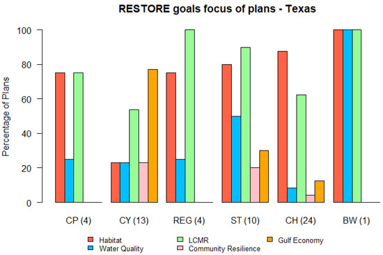
Figure 9.
The focus of conservation plans in the state of Texas with respect to CH, BW, CP, CY, REG, and ST. Focus is categorized into the goals of assessment described in Section 2.3.
4. Discussion
Across all GCR states, land conservation was identified as a strategy for addressing Habitat and LCMR priorities more frequently than Community Resilience and Gulf Economy (Figure 3, Figure 5, Figure 6, Figure 7, Figure 8 and Figure 9). Multistate (GCR-level) plans followed a similar pattern, with Habitat and LCMR priorities in far greater proportion compared to Water Quality, Community Resilience, and Gulf Economy. This is not unexpected, as typical strategies relative to revitalizing the Gulf economy often lean toward resource use, extraction, and workforce development and away from placing land in conservation and limiting development. While open space protection and utilizing green infrastructure is becoming a more recognized tool for enhancing community resilience [15,16,17], the number of plans identifying land conservation as a community resilience strategy was substantially fewer than those aiming to protect habitats, species, or waterbodies. That being said, priorities aligning with Community Resilience were identified in greater abundance in FL and LA compared to the remaining GCR states (Figure 3, Figure 6 and Figure 7). Likewise, Gulf Economy priorities were identified in greater proportion in LA relative to other GCR states.
Plans’ focus on Water Quality was dependent on the state. Many of the conservation plans that target Water Quality reference Section 303(d) of the Clean Water Act and EPA’s Water Quality Planning and Management Regulations (40 CFR Part 130), which requires states to identify impaired waterbodies within their boundaries. The D’Olive Watershed Management Plan (Appendix A—Plan 33) in AL mentions waterbodies listed under Section 303(d) and references urban development and excessive erosion and sedimentation as principal causes for impairment. The high variation in the plan focus on water quality by state may be due to different methods each state uses into assessing waterbody impairments, and differences in the proportion of their waterbodies they assess. For instance, MS has only assessed 7.2% (lowest in GCR) while FL has assessed 20.2% of its waterbodies (highest in GCR) [18]. The high percentage of FL plans focused on water quality is reflective of the state’s emphasis on protecting water resources. FL has five water management districts (WMDs), which serve to manage water use and quality. These WMDs have much of their support and direction from the Florida legislature’s passage of the Water Resources Act in 1972 and the Surface Water Improvement and Management (SWIM) [19]. The importance of Water Quality in FL is further validated by the size of their recreational fishing industry, and the proximity of human development to many waterways and unique ecosystems [20].
Across political and geomorphological subregions (subregions), Habitat and LCMR were high priority goals (Figure 4), which may be partially due to regulatory structures that mandate planning for particular resources by geographic scale. For instance, state wildlife agencies are tasked with drafting State Wildlife Action Plans (SWAPs), which identify both species (LCMR) and Habitat priorities that land conservation as a tool can address. Similarly, water quality and quantity planning are often accomplished at a basin or watershed scale because state Departments of Environmental Quality are required to draft these plans to meet EPA Clean Water Act regulations. It is widely accepted that watersheds should be of sufficient size to achieve economies of scale, take advantage of local government and technical expertise, and be viable for long-term management [21,22]. The same can be said for Hazard Mitigation plans, which are required by the Federal Emergency Management Agency and may identify conservation strategies as tools for addressing flood risk reduction and other Community Resilience priorities at the county or parish level because this is where the planning authority for those programs fall. Thus, priorities identified in plans at different subregions may be confounded with regulatory extents. Recognizing potential confounding effects, priorities aligning with RESTORE Council goals consistently emphasized Habitat and LCMR across most subregions and states.
In contrast, priorities aligning with Community Resilience and Gulf Economy goals were disproportionately underrepresented in plans we reviewed, though more prevalent in plans at the city- and county-level or parish-level compared to other subregions (Figure 4). Across subregions, plans cataloged in LA prioritized Community Resilience and Gulf Economy goals the most compared to the other Gulf States (Figure 7). LA’s relatively strong focus on Community Resilience and Gulf Economy makes sense as many of the plans cataloged refer to subsidence, hurricanes, and sea-level rise as threats to critical community infrastructure, with frequent mention of Hurricane Katrina as a recent example for why investments in conservation and other land-use planning efforts are desirable (Appendix A—Plans 253, 255, and 258). The Lafourche Parish Comprehensive Resiliency Plan mentions strong support by constituents for “the need to preserve wetlands, plan for anticipated future land loss and for coastal restoration” in order to make community resilience and economic prosperity within the parish a reality (Appendix A—Plan 253).
City-level plans show a relatively strong focus on Community Resilience and show little to no focus on ecological goals (i.e., Habitat and Water Quality). The focus on Community Resilience is natural for city planning, and land conservation priorities found within city plans would likely target human welfare (e.g., system resilience to flood risk reduction, human health, and well-being) [15,16,17,23,24]. The number of plans from urban centers reviewed for this work was fewer than nonurban plans; nevertheless, the urban community resilience plans always include increasing urban green space. Planning typically happens at these scales because the lead planning organizations have access/authority over a political boundary, funding source, or tool kit. Conservation decision makers from various federal-, state-, county-, and city-level agencies and profit/nonprofit organizations address different levels of ecological and economic stressors; and they generally work within a constructed management framework. Community Resilience planning is perhaps more effective at smaller extents such as county/parish or city because problems such as infrastructure integrity or protection from natural calamities do not often have solutions that are practical to carry out across large geographic extents. Funding for resilience planning has increased post-Hurricane Katrina in the Gulf. The United States Housing and Urban Development, Federal Emergency Management Agency, National Oceanic and Atmospheric Administration, and others have invested substantial resources in LA and MS to emphasize resilience planning, and this trend appears to be increasing in TX and FL. LA and TX showed priorities more in alignment with the Gulf Economy, which may be potentially linked to strong oil economies and potential for resource-dependent population losses along coastal areas.
The plans’ objectives may reflect the most direct threats, real or perceived, concerning the given scope of the planning area. The distinction between city- and county/parish-level plans may demonstrate differences in how respective economic drivers (urban and rural) connect to their environments. Along the Gulf coast, a substantial portion of urban economies are rooted in commercial, financial, and cultural activities, while many rural economies have foundations in agriculture and natural resources. As such, the economic wellbeing of counties and parishes often have close ties to ecosystem health, whereas city economies are often less dependent on environmental quality. In rural communities, agricultural lands and other natural resources are plentiful, protecting water resources and habitats may be more efficacious. Likewise, for cities, focusing on resilience provides insurance against threats to infrastructure, such as floods and storms, which could undermine their economy.
The associated web application (http://bit.ly/sca_gulf) provides the RESTORE Council, state and federal agencies, NGOs, and private landowners a means to understand and visualize past, existing, and future land conservation actions within their geography of interest and across the GCR. The tool can also provide the associated rationale for each conservation action. The catalog and tool can also be used to explore where and how land conservation can complement currently protected land. This tool, and our methodology of cataloging plans, could be applied to other regions of interest to help understand conservation priorities of the region of interest. The RESTORE framework adapted in this study could be replaced with other goals of conservation that may reflect the desires of the region of interest. Acknowledging that our catalog of plans is not exhaustive, the tool has been built to be dynamic so that users can contribute other existing plans not currently inventoried.
However, there may be bias in this identification of Water Quality priority prevalence in Florida due to the fact that Florida’s Water Management Districts make Surface Water Improvement, and Management plans (Appendix A—Plans 329, 333–337, 340–346, and 349–352) that are easily accessible through centralized websites, while in other states access to watershed planning documents requires a deeper exploration of available internet sources. For example, Watershed Protection Plans in Texas are authorized through multiple authorities including the Texas State Soil and Water Conservation Board as well as the Texas Commission on Environmental Quality and can be difficult to readily locate.
In addition to the aforementioned potential for confounding effects of geo-extent with regulatory jurisdiction, sampling bias toward conservation-oriented planning documents may be causing underrepresentation of local development plans, which by their nature may contain a minimal emphasis on Habitat and LCMR priorities and much more focus on Community Resilience and Gulf Economy. We encourage careful use of these findings, and only with the understanding that this inventory of plans, though extensive, was not exhaustive, and analytical outputs should be interpreted accordingly.
This study mainly focused on the total number of plans as an indicator for the presence of focus of each RESTORE Council goal. However, there are exceptions in the GCR, for example, the state of Louisiana has a master plan that implements a large number of conservation actions each of which could be individual conservation plans in other localities (Appendix A—Plan 245). Another indicator could be the investment of financial resources to address these goals. Since the plans and projects proposed in GCR are cumulative and typically focus on multiple goals, it is challenging to differentiate the information on funds being spent per individual RESTORE goal. Thus the analysis based on a number of plans is a safe alternative, and future research should examine ecosystem services provided by plans and projects at a goal-level to further maximize efficiencies in funding expenditures.
5. Conclusions
This catalog of land conservation plans and its associated online tool is the first of its kind for the GCR and shows the diversity of motivations to conserve land across the region. From our cataloging exercise, we realized a need for a centralized database across the GCR for conservation priorities and planning. One could adapt our tool and methods for cataloging plans to better understand conservation goals in other regions of interest. By developing a catalog with the use of conservation goals that are relevant to the desired region, one could achieve a similar holistic understanding for how the goals are being met in that region.
The observed conservation motives from the catalog provide a baseline, with respect to the RESTORE Council goals, for what land conservation efforts exist in the GCR, and may help clarify gaps in conservation as an impetus for future land protections. Collectively, land conservation efforts in the GCR address all of the RESTORE goals; however, there appear to be strong associations among RESTORE goals and originating geographic extent of the plans. Whereas conservation plans address Habitat and LCMR across the GCR at relatively even rates, focuses on Water Quality, Community Resilience, and Gulf Economy appear to be more dependent on locality. For instance, the state of Florida has a high percentage of plans focused on improving water quality and quantity across multiple subregions, and Louisiana has a very high percentage of county/parish plans with a focus on Community Resilience and Gulf Economy (Figure 7). City and county/parish plans have a similar proportion of focus on LCMR, Community Resilience, and Gulf Economy, but substantially differ in focus on Habitat and Water Quality. These outcomes of our analysis highlight distinctions and similarities in conservation priority across the GCR, and conservation planners may use this information to guide future conservation actions that enhance protections for the region’s diverse landscape, species, and economic activity. Acknowledging the distinctions in percentage of plans focused on RESTORE goals, encouraging better representation of certain priorities from plans across subregions could be accomplished with more integration of ecological and socioeconomic values [25]. For instance, a coastal area may be of interest for conservation not only for its use by a diverse group of species, but also to provide flood mitigation for a nearby community. In this case, the simultaneous consideration of biodiversity and flood mitigation could optimize the value of the conservation action. A follow-up evaluation that examines and evaluates the regulatory framework(s) and resource structures guiding the development of planning efforts within states and across the GCR may help to illuminate geographic differences or goal disparities.
Author Contributions
A.L. conceived the idea of this paper. S.S., A.S., and J.L. performed the writing and analysis. J.R. led the initial inventory and synthesis of plans and contributed to writing. K.E. initiated the project and contributed to writing and revisions.
Funding
This research was funded by the United States Department of Interior, grant number F17AC00267.
Acknowledgments
This paper is a contribution of the Mississippi Agricultural and Forestry Experiment Station and the Forest and Wildlife Research Center, Mississippi State University The authors would like to thank John Tirpak, Ben Wilson, Chris Pease, Matt Snider, David Reeves, and Stephanie Sharuga from U.S Fish and Wildlife Service; Steve Ashby and Wes Burger from Mississippi State University; and Jessica Henkel from the Gulf Ecosystem Restoration Council for their contributions to this work
Conflicts of Interest
The authors declare no conflicts of interest.
Appendix A
Table A1.
Summary of 352 plans that were included in the catalog. The plans are color coded by state or GCR: AL—light green; MS—blue; GCR—yellow; TX—orange; LA—gold; FL—dark green.
Table A1.
Summary of 352 plans that were included in the catalog. The plans are color coded by state or GCR: AL—light green; MS—blue; GCR—yellow; TX—orange; LA—gold; FL—dark green.
| Code | State | Plan Name | ACQ1 | EAS1 | STE1 | |
|---|---|---|---|---|---|---|
| 1 | BI | AL | Alabama Barrier Island Restoration Assessment | 0 | 0 | 1 |
| 2 | BI | AL | Increasing Climate Resilience on Dauphin Island Through Land Use Planning | 0 | 1 | 1 |
| 3 | BI | AL | Dauphin Island Bird Habitat Acquisition and Enhancement Program | 1 | 1 | 1 |
| 4 | BI | AL | Dauphin Island Strategic Plan-A 20-year vision | 1 | 1 | 1 |
| 5 | CZ | AL | Alabama Coastal Area Management Program Section 309 | 0 | 0 | 0 |
| 6 | CZ | AL | Alabama Coastal Impact Assistance Program | 1 | 1 | 1 |
| 7 | CZ | AL | Mobile Bay Shore Habitat Conservation and Acquisition Initiative—Phase II | 1 | 1 | 1 |
| 8 | CZ | AL | Alabama Coastal and Estuarine Land Conservation Program, Program Implementation Strategy | 1 | 1 | 1 |
| 9 | CZ | AL | Alabama Coastal Area Management Program IV | 1 | 1 | 1 |
| 10 | CZ | AL | A roadmap to resilience: Toward A Healthier Environment, Society and Economy for Coastal Alabama | 1 | 1 | 1 |
| 11 | CZ | AL | Gulf Highlands Conservation Acquisition | 1 | 1 | 1 |
| 12 | CZ | AL | Bon Secour National Wildlife Refuge Acquisition | 1 | 1 | 1 |
| 13 | CZ | AL | Lightning Point Acquisition and Restoration Project—Phase I | 1 | 1 | 1 |
| 14 | CP | AL | Gulf Shores Vision 2025 for Sustainability | 1 | 1 | 1 |
| 15 | CP | AL | Mobile County Conservation Acquisition | 1 | 1 | 1 |
| 16 | CP | AL | Baldwin County Wetland Conservation Plan | 1 | 1 | 1 |
| 17 | CP | AL | Baldwin County Multi Hazard Mitigation Plan | 1 | 1 | 1 |
| 18 | ES | AL | Grand Bay Acquisition | 1 | 1 | 1 |
| 19 | ES | AL | Mobile Bay Comprehensive Conservation and Management Plan | 0 | 0 | 1 |
| 20 | ES | AL | Weeks Bay National Estuarine Research Reserve Management Plan | 1 | 1 | 1 |
| 21 | ES | AL | Salt Aire Shoreline Restoration | 1 | 1 | 1 |
| 22 | CY | AL | Bon Secour-Oyster Bay Wetland Acquisition Project | 1 | 1 | 1 |
| 28 | BW | AL | D’Olive Watershed Restoration | 0 | 0 | 1 |
| 29 | BW | AL | Bayou La Batre Watershed Assessment | 0 | 0 | 0 |
| 30 | BW | AL | Fowl River Watershed Restoration | 1 | 0 | 1 |
| 31 | BW | AL | Fowl River Watershed Restoration: Coastal Spits and Wetlands Project | 1 | 1 | 1 |
| 32 | BW | AL | Eightmile Creek Watershed Management Plan | 0 | 0 | 0 |
| 33 | BW | AL | D’Olive Creek Watershed Management Plan | 1 | 1 | 0 |
| 34 | BW | AL | Weeks Bay Watershed Nonpoint Source Prioritization Project and Site Conservation Plan | 1 | 1 | 1 |
| 35 | BW | AL | Fowl River Watershed Management Plan | 1 | 1 | 1 |
| 36 | BW | AL | Dog River Draft Water Management Plan | 1 | 1 | 1 |
| 37 | BW | AL | Weeks Bay Watershed Management Plan | 1 | 1 | 1 |
| 38 | BW | AL | Three Mile Creek Watershed | 1 | 1 | 1 |
| 39 | BW | AL | Bon Secour River, Oyster Bay, Skunk Bayou Watershed Management Plan | 1 | 1 | 1 |
| 40 | BW | AL | Coastal Alabama River Basin Management Plan | 0 | 0 | 0 |
| 41 | REG | AL | Coastal Habitat Restoration Planning Initiative | 1 | 1 | 1 |
| 42 | REG | AL | Bon Secour National Wildlife Refuge Habitat Management Plan | 0 | 0 | 1 |
| 43 | REG | AL | Gulf Coast Joint Venture: Mobile Bay Initiative | 1 | 1 | 1 |
| 44 | REG | AL | Conserving Alabama’s Coastal Habitats: Acquisition and Restoration Priorities of Mobile and Baldwin Counties | 1 | 1 | 1 |
| 45 | ST | AL | Alabama Wildlife Action Plan | 1 | 1 | 1 |
| 46 | ST | AL | State Comprehensive Outdoor Recreation Plan | 1 | 1 | 1 |
| 47 | CY | MS | D’Iberville Comprehensive Plan | 0 | 0 | 1 |
| 48 | CY | MS | Pascagoula Comprehensive Plan | 0 | 0 | 1 |
| 49 | CY | MS | City of Ocean Springs Comprehensive Plan | 0 | 0 | 1 |
| 50 | CY | MS | Waveland Comprehensive Plan | 0 | 0 | 1 |
| 51 | CY | MS | Diamondhead Comprehensive Plan | 0 | 0 | 1 |
| 52 | CY | MS | Biloxi Comprehensive Plan | 0 | 0 | 1 |
| 53 | CY | MS | City of Gautier Comprehensive Plan 2030 | 0 | 0 | 1 |
| 54 | CY | MS | Pass Christian Comprehensive Plan | 0 | 0 | 1 |
| 55 | CY | MS | City of Gautier, Mississippi, Strategic Plan | 0 | 0 | 1 |
| 56 | CY | MS | Moss Point Comprehensive Plan | 0 | 0 | 1 |
| 57 | CY | MS | Bay St. Louis Hazard Mitigation Plan | 0 | 1 | 1 |
| 58 | CY | MS | City of Long Beach Local Hazard Mitigation Plan | 0 | 1 | 1 |
| 59 | CY | MS | Waveland Local Hazard Mitigation Plan | 0 | 1 | 1 |
| 60 | CY | MS | City of Pascagoula Local Hazard Mitigation Plan | 0 | 1 | 1 |
| 61 | CY | MS | Gulfport Hazard Mitigation Flood Protection Plan 2013–2017 | 0 | 1 | 1 |
| 62 | CY | MS | Biloxi Mitigation Floodplain Management Plan 2013–2017 | 0 | 1 | 1 |
| 63 | CY | MS | Long Beach Comprehensive Plan | 1 | 0 | 1 |
| 64 | CY | MS | Hiller Park Environmental Enhancement Project | 0 | 1 | 1 |
| 65 | CY | MS | RESTORE Act-Gautier Program Overview | 1 | 1 | 1 |
| 66 | CP | MS | Jackson County Comprehensive Plan | 1 | 1 | 1 |
| 67 | CP | MS | Harrison County Comprehensive Plan | 1 | 1 | 1 |
| 68 | CP | MS | 2012 Jackson County Multi-jurisdictional Hazard Mitigation Plan | 0 | 1 | 0 |
| 69 | REG | MS | Coastal Wetlands Priority Acquisition Plan for Hancock, Harrison, and Jackson Counties | 1 | 0 | 0 |
| 70 | REG | MS | Mississippi Renewal Forum Summary Report | 0 | 1 | 0 |
| 71 | REG | MS | Mississippi Gulf Coast Water Quality Improvement Program | 0 | 0 | 0 |
| 72 | REG | MS | Gulf of Mexico Restoration: NRCS Strategy for Success | 0 | 1 | 1 |
| 73 | REG | MS | Sea Turtle Recovery Plans | 0 | 1 | 1 |
| 74 | NA | GCR | Gulf of Mexico Restoration: A Private Lands Vision for Success | 0 | 1 | 1 |
| 75 | REG | MS | Habitat Restoration and Conservation in Turkey Creek—Phase I | 1 | 1 | 1 |
| 76 | REG | MS | Habitat Restoration: Federal Lands Program—Phase I | 1 | 1 | 1 |
| 77 | REG | MS | Acquisition of priority tracts for coastal habitat connectivity—Phase I | 1 | 1 | 1 |
| 78 | REG | MS | Gulf Coast Joint Venture: Coastal Mississippi Wetlands Initiative | 1 | 1 | 1 |
| 79 | REG | MS | Pascagoula River Corridor Acquisitions | 1 | 1 | 1 |
| 80 | REG | MS | Coastal Headwaters Protection Due Diligence | 1 | 1 | 1 |
| 81 | NA | GCR | Gulf of Mexico Initiative | 0 | 0 | 0 |
| 82 | NA | GCR | US Fish and Wildlife Service. Vision Document for the Strategic Plan for the Coastal Program | 0 | 0 | 1 |
| 83 | NA | GCR | Gulf Sturgeon Critical Habitat Designation | 0 | 1 | 0 |
| 84 | NA | GCR | Vision for a Healthy Gulf of Mexico Watershed | 1 | 1 | 1 |
| 85 | NA | GCR | Gulf Sturgeon Recovery/Management Plan | 0 | 1 | 0 |
| 86 | NA | GCR | America’s Gulf Coast: A Long term Recovery Plan after the Deepwater Horizon Oil Spill | 0 | 1 | 0 |
| 87 | NA | GCR | National Fish Habitat Action Plan | 0 | 1 | 1 |
| 88 | NA | GCR | Northern Gulf Coastal Program | 0 | 1 | 1 |
| 89 | NA | GCR | Mississippi-Alabama Sea Grant Consortium. 2014–2017 Strategic Plan. | 1 | 1 | 1 |
| 90 | NA | GCR | Gulf Restoration Network United for A Healthy Gulf Strategic Plan | 0 | 0 | 0 |
| 91 | NA | GCR | Southeast United States Regional Waterbird Conservation Plan | 0 | 0 | 0 |
| 92 | NA | GCR | NFHP—National Fish Habitat Action Plan | 0 | 0 | 0 |
| 93 | NA | GCR | Northern Gulf of Mexico Sentinel Site Cooperative Implementation Plan | 0 | 0 | 0 |
| 94 | NA | GCR | Gulf Coast Joint Venture: Mississippi River Coastal Wetlands Initiative | 0 | 0 | 1 |
| 95 | NA | GCR | Southeastern Coastal Plains-Caribbean Region Report: US Shorebird Conservation Plan | 0 | 0 | 1 |
| 96 | NA | GCR | National Wildlife Refuge at Risk Species Report | 0 | 0 | 1 |
| 97 | NA | GCR | Ag Land Easement (ALE) program | 0 | 1 | 1 |
| 98 | NA | GCR | Gulf of Mexico Initiative (GOMI) | 0 | 1 | 1 |
| 99 | NA | GCR | Longleaf Pine Initiative Implementation Strategy | 0 | 1 | 1 |
| 100 | NA | GCR | Migratory Birds Habitat Restoration | 0 | 1 | 1 |
| 101 | NA | GCR | Mississippi River Basin Initiative (MRBI) | 0 | 1 | 1 |
| 102 | NA | GCR | Emergency Watershed Protection Floodplain Easement | 0 | 1 | 1 |
| 103 | NA | GCR | Conservation Innovation Grants | 0 | 1 | 1 |
| 104 | NA | GCR | North American Waterfowl Mgmt. Plan | 1 | 1 | 1 |
| 105 | NA | GCR | Open Pine Landbird Plan West Gulf Coastal Plain/Ouachitas | 1 | 1 | 1 |
| 106 | NA | GCR | Gopher Tortoise | 1 | 1 | 1 |
| 107 | NA | GCR | Gulf Coast Vulnerability Assessment | 1 | 1 | 1 |
| 108 | NA | GCR | Regional Conservation Partnership Program | 1 | 1 | 1 |
| 109 | NA | GCR | Gulf of Mexico Alliance Governors Action Plan III for Healthy & Resilient Coasts | 1 | 1 | 1 |
| 110 | NA | GCR | Audubon Strategic Plan; Extending Our Conservation Reach Together | 1 | 1 | 1 |
| 111 | NA | GCR | Atlantic Coast Joint Venture | 1 | 1 | 1 |
| 112 | NA | GCR | Environmental Quality Incentives Program | 1 | 1 | 1 |
| 113 | NA | GCR | North American Waterfowl Management Plan, Gulf Coast Joint Venture: Mottled Duck Conservation Plan | 1 | 1 | 1 |
| 114 | NA | GCR | Gulf Coast Joint Venture: Chenier Plain Initiative | 1 | 1 | 1 |
| 115 | NA | GCR | Fall Habitat Objectives for Priority Gulf Coast Joint Venture Shorebird Species Using Managed Wetlands and Grasslands | 1 | 1 | 1 |
| 116 | NA | GCR | USFS Forest Legacy Program | 1 | 1 | 1 |
| 117 | NA | GCR | Little Blue Heron Conservation Plan | 1 | 1 | 1 |
| 118 | NA | GCR | Atlantic Flyway Shorebird Initiative | 1 | 1 | 1 |
| 119 | NA | GCR | Restoration, Management, and Monitoring of Forest Resources in the Mississippi Alluvial Valley: Recommendations for Enhancing Wildlife Habitat by the Lower Mississippi Joint Venture, 2007 | 1 | 1 | 1 |
| 120 | NA | GCR | Partners in Flight Landbird Conservation Plan Gulf Coastal Prairie | 1 | 1 | 1 |
| 121 | NA | GCR | Gulf Coast Joint Venture Landbird Conservation Plan Bird Conservation Regions 25, 26, & 27 | 1 | 1 | 1 |
| 122 | NA | GCR | Gulf Coast Joint Venture Conservation Planning for Reddish Egret | 1 | 1 | 1 |
| 123 | NA | GCR | Southeast Conservation Adaptation Strategy (SECAS) | 1 | 1 | 1 |
| 124 | NA | GCR | Vision for a Healthy Gulf of Mexico Watershed | 1 | 1 | 1 |
| 125 | NA | GCR | Gulf Coast Joint Venture: Mississippi River Coastal Wetlands Initiative | 1 | 1 | 1 |
| 126 | NA | GCR | North American Waterbird Conservation Plan | 1 | 1 | 1 |
| 127 | NA | GCR | PGCLCVision Doc | 1 | 1 | 1 |
| 128 | NA | GCR | National Water Quality Initiative (NWQI) | 1 | 1 | 1 |
| 129 | NA | GCR | Gulf Coast Joint Venture | 1 | 1 | 1 |
| 130 | NA | GCR | Agricultural Conservation Easement Program (ACEP) | 1 | 1 | 1 |
| 131 | NA | GCR | 2016 Landbird Conservation Plan | 1 | 1 | 1 |
| 132 | NA | GCR | Healthy Forests Reserve Program (HFRP) | 1 | 1 | 1 |
| 133 | NA | GCR | TNC-Identification of Priority Sites for Conservation in the Northern Gulf of Mexico: An Ecoregional Plan | 1 | 1 | 1 |
| 134 | NA | GCR | Targeted Pollinator Habitat Efforts | 1 | 1 | 1 |
| 135 | REG | MS | Go Coast 2020 Final Report | 1 | 1 | 1 |
| 136 | REG | MS | Mississippi Sandhill Crane National Wildlife Refuge Comprehensive Conservation Plan | 0 | 0 | 1 |
| 137 | REG | MS | Invasive Species Management Plan for the Grand Bay National Estuarine Research Reserve | 0 | 1 | 0 |
| 138 | REG | MS | Project Management Plan for Selected Beneficial Use Projects Along Coastal Mississippi | 0 | 1 | 0 |
| 139 | REG | MS | Mississippi Coastal Nutrient Reduction Strategies | 0 | 1 | 0 |
| 140 | REG | MS | Grand Bay National Wildlife Refuge Comprehensive Conservation Plan | 0 | 1 | 1 |
| 141 | REG | MS | Mississippi Coastal Improvements Program, Comprehensive Plan Elements | 0 | 1 | 1 |
| 142 | REG | MS | Grand Bay National Estuarine Research Reserve Management Plan 2013–2018: | 0 | 1 | 1 |
| 143 | REG | MS | Coastal Wetlands Priority Acquisition Plan for Hancock, Harrison, and Jackson Counties | 1 | 0 | 0 |
| 144 | REG | MS | State Coastal Impact Assistance Plan | 1 | 0 | 0 |
| 145 | REG | MS | Master Plan for the Beneficial Use of Dredge Material for Coastal Mississippi | 1 | 1 | 0 |
| 146 | REG | MS | MS Coastal Preserves Mission, Vision and Goals | 1 | 1 | 0 |
| 147 | REG | MS | Coastal Preserve Program Plan | 1 | 1 | 0 |
| 148 | REG | MS | Draft Land Protection Plan and Draft Environmental Assessment for the proposed expansion of Grand Bay NWR | 1 | 1 | 1 |
| 149 | NA | GCR | Mississippi-Alabama Sea Grant Consortium. 2014–2017 Strategic Plan. | 1 | 1 | 1 |
| 150 | ST | MS | Gulf Mexico Alliance Governor’s Action Plan II: 2009–2014 | 0 | 1 | 1 |
| 151 | ST | MS | Mississippi Gopher Frog Critical Habitat Designation | 0 | 1 | 1 |
| 152 | ST | MS | MS State Management Plan for Aquatic Invasive Species | 0 | 1 | 1 |
| 153 | ST | MS | Mississippi’s Comprehensive Wildlife Conservation Strategy, 2005 | 0 | 1 | 1 |
| 154 | ST | MS | Mississippi’s Basin Management Approach | 0 | 1 | 1 |
| 155 | ST | MS | Draft Environmental Impact Statement, Revised Land and Resource Management Plan National Forests in Mississippi | 0 | 1 | 1 |
| 156 | ST | MS | Mississippi’s Assessment of Forest Resources and Forest Resource Strategy | 1 | 0 | 1 |
| 157 | ST | MS | MS Forest Legacy Program Assessment of Need | 1 | 1 | 0 |
| 158 | ST | MS | State of Mississippi Coastal and Estuarine Land Conservation Program (CELCP) Plan | 1 | 1 | 0 |
| 159 | ST | MS | Mississippi Statewide Comprehensive Outdoor Recreation Plan | 1 | 1 | 1 |
| 160 | CZ | MS | Mississippi-Alabama Sea Grant Research Plan | 0 | 0 | 0 |
| 161 | CZ | MS | Mississippi Coastal Program (MCP) | 1 | 1 | 1 |
| 162 | BI | TX | Galveston Island State Park Marsh Restoration & Protection—Phase III | 0 | 0 | 0 |
| 163 | BI | TX | Smith Oaks Bird Sanctuary Rookery Island Restoration and Enhancement | 0 | 0 | 0 |
| 164 | BI | TX | Dagger Island Restoration Project | 0 | 0 | 0 |
| 165 | BI | TX | Oyster Lake Shoreline Protection and Restoration | 0 | 0 | 0 |
| 166 | BI | TX | Follets Island Land Acquisition and Conservation Program—Phase I | 1 | 1 | 1 |
| 167 | BI | TX | Coastal Heritage Preserve Initiative: Bayside Acquisition and Easement | 1 | 1 | 1 |
| 168 | ES | TX | Galveston Bay Plan | 1 | 1 | 1 |
| 169 | CZ | TX | Mad Island Marsh Preserve Shoreline Protection and Coastal Ecosystem Restoration—Phase I | 0 | 0 | 0 |
| 170 | CZ | TX | Beach-nesting and Wintering Bird Protection and Habitat Stewardship | 0 | 0 | 1 |
| 171 | CZ | TX | Salt Bayou Beach Ridge Restoration—Engineering and Design | 0 | 0 | 1 |
| 172 | CZ | TX | Sabine Ranch Acquisition | 1 | 1 | 1 |
| 173 | CZ | TX | Gulf Coast Migratory Waterfowl Habitat Enhancement | 1 | 1 | 1 |
| 174 | CP | TX | Aransas County Floodplain Management Plan | 0 | 0 | 0 |
| 175 | CZ | TX | Hydrological Restoration of Brazoria National Wildlife Refuge Wetlands—Phase I | 0 | 0 | 0 |
| 176 | REG | TX | Rebuild Flight Cage and Enclosure Complex for Rehabilitated Birds | 0 | 0 | 0 |
| 177 | CZ | TX | Sea Rim State Park Coastal Dune Restoration | 0 | 0 | 1 |
| 178 | REG | TX | Restoring Colonial Waterbirds on the Texas Coast | 0 | 0 | 1 |
| 179 | CZ | TX | Hydrologic Restoration of the Salt Bayou Watershed | 0 | 0 | 1 |
| 180 | CP | TX | Bee Groundwater Conservation District Management Plan | 0 | 0 | 0 |
| 181 | CP | TX | Hays County Regional Habitat Conservation Plan | 1 | 0 | 0 |
| 182 | CP | TX | Comal County Regional Habitat Conservation Plan | 1 | 1 | 0 |
| 183 | CP | TX | Strategic Conservation Plan | 1 | 1 | 0 |
| 184 | CP | TX | Lost Pines Habitat Conservation Plan for Bastrap County, Texas | 1 | 1 | 1 |
| 185 | CZ | TX | Carancahua Bay Habitat Preservation and Enhancement—Phase I | 1 | 1 | 1 |
| 186 | CZ | TX | Bahia Grande Coastal Corridor–Holly Beach Tract Acquisition | 1 | 1 | 1 |
| 187 | CZ | TX | Laguna Atascosa National Wildlife Refuge Coastal Marsh and Dunes Acquisition | 1 | 1 | 1 |
| 188 | CZ | TX | Dollar Bay-Moses Lake Shoreline Enhancement and Restoration | 0 | 0 | 0 |
| 189 | CZ | TX | Powderhorn Ranch Land Acquisition | 1 | 0 | 1 |
| 190 | CZ | TX | Candy Abshier Wildlife Management Area Shoreline Protection and Marsh Restoration | 0 | 1 | 1 |
| 191 | ES | TX | Egery Flats Marsh Restoration | 0 | 0 | 1 |
| 192 | ES | TX | Nueces Bay Rookery Islands Restoration | 0 | 0 | 1 |
| 193 | CZ | TX | Falcon Point Ranch Conservation and Wetland Restoration | 1 | 1 | 1 |
| 194 | CZ | TX | Anahuac National Wildlife Refuge Coastal Marsh Acquisition | 1 | 1 | 0 |
| 195 | ES | TX | Virginia Point Shoreline Protection and Estuarine Restoration | 0 | 0 | 1 |
| 196 | ES | TX | West Galveston Bay Conservation Corridor Habitat Preservation | 1 | 1 | 1 |
| 197 | ES | TX | Greens Lake Protection and Marsh Restoration: Engineering & Design | 0 | 0 | 0 |
| 198 | CZ | TX | Restoration of J.D. Murphree Wildlife Management Area Water Management Infrastructure | 0 | 1 | 1 |
| 199 | ES | TX | Mission-Aransas Reserve Management Plan | 0 | 1 | 1 |
| 200 | REG | TX | Gulf Coast Joint Venture: Laguna Madre Initiative | 1 | 1 | 1 |
| 201 | REG | TX | Gulf Coast Joint Venture: Texas Mid-Coast Initiative | 1 | 1 | 1 |
| 202 | CY | TX | City of Temple Comprehensive Plan | 0 | 0 | 0 |
| 203 | CY | TX | City of Georgetown Comprehensive Plan | 0 | 0 | 0 |
| 204 | CY | TX | Carrollton City Comprehensive Plan | 0 | 0 | 0 |
| 205 | CY | TX | City of Live Oak Comprehensive Plan | 0 | 0 | 0 |
| 206 | CY | TX | City of Heath Comprehensive Plan | 0 | 0 | 0 |
| 207 | CY | TX | City of McKinney Comprehensive Plan | 0 | 0 | 0 |
| 208 | CY | TX | City of Victoria Comprehensive Plan | 0 | 0 | 0 |
| 209 | CY | TX | City of Midland Comprehensive Plan | 0 | 0 | 0 |
| 210 | CY | TX | City of Melissa Comprehensive Plan | 0 | 0 | 0 |
| 211 | CY | TX | City of Cedar Park Comprehensive Plan | 0 | 0 | 0 |
| 212 | CY | TX | City of Flushear Comprehensive Plan | 0 | 1 | 0 |
| 213 | CY | TX | City of Leaque Comprehensive Plan | 0 | 1 | 0 |
| 214 | CY | TX | City of Rosenberg Comprehensive Plan | 0 | 1 | 0 |
| 215 | CY | TX | City of Midlothian Comprehensive Plan | 0 | 1 | 0 |
| 216 | CY | TX | City of Huntsville Comprehensive Plan | 0 | 1 | 0 |
| 217 | CY | TX | City of Sachse Comprehensive Plan | 0 | 1 | 0 |
| 218 | BW | TX | San Bernard River Watershed Protection Plan | 0 | 1 | 0 |
| 219 | CY | TX | City of Sugar Land Comprehensive Plan | 0 | 1 | 1 |
| 220 | CY | TX | Texas City Comprehensive Plan | 0 | 1 | 1 |
| 221 | CY | TX | City of Missouri Comprehensive Plan | 1 | 0 | 0 |
| 222 | CY | TX | City of Fate Comprehensive Plan | 1 | 0 | 0 |
| 223 | CY | TX | City of Fort Worth Comprehensive Plan | 1 | 0 | 1 |
| 224 | CY | TX | City of Magnolia Comprehensive Plan | 1 | 0 | 1 |
| 225 | CY | TX | City of Nolanville Comprehensive Plan | 1 | 1 | 0 |
| 226 | ST | TX | Coastal Bend Mitigation Action Plan | 0 | 0 | 0 |
| 227 | ST | TX | Texas Water Development Board Strategic Plan Fiscal Years 2007–2011 | 0 | 0 | 0 |
| 228 | CZ | TX | Coastal Texas 2020; A Clear Vision for the Texas Coast | 0 | 0 | 0 |
| 229 | ST | TX | Texas Conservation Action Plan: Gulf Coast Prairies and Marshes | 0 | 1 | 0 |
| 230 | ST | TX | Texas Coastal Estuarine Land Conservation Program Plan (CELCP) | 0 | 1 | 0 |
| 231 | TX | TX | Monarch Butterfly Habitat Development Strategy (Working lands for Wildlife) | 0 | 1 | 1 |
| 232 | ST | TX | Texas Wetlands Conservation Plan | 1 | 1 | 0 |
| 233 | REG | TX | Gulf-Houston Regional Conservation Plan | 1 | 1 | 0 |
| 234 | ST | TX | Texas Trustee Implementation Group Restoration Plan | 1 | 1 | 0 |
| 235 | ST | TX | Land and Water Resources Conservation and Recreation Plan | 1 | 1 | 1 |
| 236 | ST | TX | Texas Multiyear Implementation Plan | 1 | 1 | 1 |
| 237 | ST | TX | Texas Conservation Action Plan Handbooks | 1 | 1 | 1 |
| 238 | ST | TX | Texas State Soil and Water Conservation Board Strategic Plan | 1 | 1 | 1 |
| 239 | ST | TX | Texas Genral Land Office Agency Strategic Plan | 1 | 1 | 1 |
| 240 | CZ | TX | Texas Coastal Management Program Section 309 Assessment and Strategies Report 2006–2010 | 1 | 1 | 1 |
| 241 | CZ | TX | Texas Coastal Management Program Final EIS | 1 | 1 | 1 |
| 242 | BI | LA | Elmer’s Island Wildlife Refuge Management Plan | 1 | 0 | 1 |
| 243 | BW | LA | Next Steps for a Healthy Gulf of Mexico Watershed Atchafalaya Landscape at a Glance | 1 | 0 | 1 |
| 244 | BW | LA | Atchafalaya Basin Annual Plan | 0 | 0 | 0 |
| 245 | CZ | LA | Louisiana’s Comprehensive Master Plan for a Sustainable Coast | 0 | 0 | 0 |
| 246 | CZ | LA | Louisiana Coastal and Estuarine Land Conservation Program | 1 | 1 | 1 |
| 247 | ES | LA | BTNEP Conservation Mgmt Plan | 0 | 0 | 1 |
| 248 | CP | LA | New Directions 2025, St. Tammany Land Use Plan | 0 | 0 | 0 |
| 249 | CP | LA | Resilient New Orleans Strategic Actions to Shape our future city | 0 | 0 | 0 |
| 250 | CP | LA | Tangipahoa Parish Comprehensive Plan | 0 | 0 | 0 |
| 251 | CP | LA | Envision Livingston a Comprehensive Master Plan for Investing in Our Future | 0 | 0 | 0 |
| 252 | CP | LA | St. James Government Comprehensive Plan 2030 | 0 | 0 | 0 |
| 253 | CP | LA | Lafourche Parish Comprehensive Resiliency Plan | 0 | 0 | 1 |
| 254 | CP | LA | Terrebonne Parish Vision 2030 | 0 | 0 | 1 |
| 255 | CP | LA | St. Bernard Comprehensive Plan | 0 | 1 | 1 |
| 256 | CP | LA | Vermilion Parish Comprehensive Resiliency Plan | 1 | 1 | 1 |
| 257 | CP | LA | St. Mary Parish Comprehensive Plan | 1 | 1 | 1 |
| 258 | CP | LA | St. John the Baptist Parish Comprehensive Land Use Plan | 1 | 1 | 1 |
| 259 | CP | LA | Plan Ascension the Blueprint for Our Future | 1 | 1 | 1 |
| 260 | CP | LA | Assumption Parish Comprehensive Plan | 1 | 1 | 1 |
| 261 | CP | LA | St. Charles Parish 2030 Comprehensive Plan | 1 | 1 | 1 |
| 262 | CP | LA | Plaquemines Parish Comprehensive Master Plan | 1 | 1 | 1 |
| 263 | CP | LA | St. Charles 2030 Comprehensive Plan | 0 | 1 | 1 |
| 264 | REG | LA | Greater New Orleans Water Management Plan | 0 | 0 | 0 |
| 265 | ST | LA | Resettlement as a Resilience Strategy and the Case of Isle de Jean Charles | 1 | 0 | 0 |
| 266 | CP | LA | St. Bernard and Plaquemines Parish Land use and transportation plan | 1 | 0 | 0 |
| 267 | NA | GCR | Next Steps for a Healthy Gulf of Mexico Watershed Mississippi Alluvial Valley | 1 | 1 | 1 |
| 268 | NA | GCR | Next Steps for a Healthy Gulf of Mexico Watershed Mississippi River Coastal Wetlands and Barrier Islands Landscapes at a Glance | 1 | 1 | 1 |
| 269 | CZ | LA | Louisiana Coastal Management Program Assessment and Strategy 2006–2011 | 0 | 0 | 0 |
| 270 | ST | LA | Louisiana Statewide Forest Resource Assessment and Strategy | 0 | 1 | 1 |
| 271 | ST | LA | Louisiana State Comprehensive Outdoor Recreation Plan (SCORP) | 1 | 0 | 1 |
| 272 | ST | LA | Louisiana Department of Wildlife and Fisheries Strategic Plan 2017–2018 through 2021–2022 | 1 | 1 | 1 |
| 273 | ST | LA | Louisiana Comprehensive Wildlife Conservation Strategy (CWCS) | 1 | 1 | 1 |
| 274 | ST | LA | Louisiana Wildlife Action Plan | 1 | 1 | 1 |
| 275 | ST | LA | Louisiana Forest Legacy Assessment of Need | 1 | 1 | 1 |
| 276 | ST | LA | Louisiana Nutrient Management Strategy | 1 | 1 | 1 |
| 277 | ST | LA | Louisiana Department of Wildlife and Fisheries Master Plan for Wildlife Management Areas and Refuges | 1 | 1 | 1 |
| 278 | ST | LA | LA Coastal Forest Conservation Initiative 2012 | 1 | 0 | 0 |
| 279 | BW | LA | Bayou Lafourche | 0 | 1 | 1 |
| 280 | BW | LA | Bayou Chene Watershed Implementation Plan | 0 | 1 | 1 |
| 281 | BW | LA | Big Creek Watershed Implementation Plan | 0 | 1 | 1 |
| 282 | BW | LA | Bayou Queue de Tortue Watershed Implementation Plan | 0 | 1 | 1 |
| 283 | BW | FL | Lower St. Johns River Basin SWIM Plan | 0 | 0 | 0 |
| 284 | BW | FL | Water Quality Improvements to Enhance Fisheries Habitat in the Lower Choctawhatchee River Basin—Phase I | 0 | 0 | 0 |
| 285 | BW | FL | Comprehensive Everglades Restoration Plan | 1 | 1 | 1 |
| 286 | BW | FL | Northern Coastal Basin SWIM Plan | 1 | 1 | 1 |
| 287 | BW | FL | St. Marys River SWIM Plan | 1 | 1 | 1 |
| 288 | BW | FL | Upper Ocklawaha RIver Basin SWIM Plan | 1 | 1 | 1 |
| 289 | BW | FL | Upper St. Johns River Basin SWIM Plan | 1 | 1 | 1 |
| 290 | BW | FL | Middle St. Johns River Basin SWIM Plan | 1 | 1 | 1 |
| 291 | BW | FL | Orange Creek Basin SWIM Plan | 1 | 1 | 1 |
| 292 | REG | FL | Comprehensive Panhandle Coastal Bird Conservation | 0 | 0 | 0 |
| 293 | CP | FL | Restoration of Florida’s Coastal Dune Lakes | 0 | 0 | 0 |
| 294 | CP | FL | Destin Harbor, Joe’s Bayou, and Indian Bayou Water Quality Improvement | 0 | 0 | 0 |
| 295 | CP | FL | Florida Forest Service: Rural and Family Lands Protection Program (RFLPP) | 0 | 1 | 1 |
| 296 | CP | FL | Bay County Comprehensive Plan | 0 | 1 | 1 |
| 297 | CP | FL | Florida Forest Legacy Program Assessment of Need | 1 | 1 | 1 |
| 298 | CP | FL | Charlotte County 2050 | 1 | 1 | 1 |
| 299 | CP | FL | Citrus County Comprehensive Plan | 1 | 1 | 1 |
| 300 | CP | FL | Collier County RESTORE multi-year implementation plan | 1 | 1 | 1 |
| 301 | CP | FL | Dixie County Comprehensive Plan | 1 | 1 | 1 |
| 302 | CP | FL | Escambia County Comprehensive Plan 2030 | 1 | 1 | 1 |
| 303 | CP | FL | Franklin County RESTORE Act Multiyear Implementation Plan | 1 | 1 | 1 |
| 304 | CP | FL | Gulf County Habitat Conservation Plan | 1 | 1 | 1 |
| 305 | CP | FL | Hernando County Comprehensive Plan 2040 | 1 | 1 | 1 |
| 306 | CP | FL | Jan K. Platt Environmental Lands Acquisition and Protection Program (ELAPP) | 1 | 1 | 1 |
| 307 | CP | FL | Comprehensive Plan 2025 Jefferson County, Florida | 1 | 1 | 1 |
| 308 | CP | FL | Levy County Comprehensive Plan | 1 | 1 | 1 |
| 309 | CP | FL | Manatee County Florida Comprehensive Plan | 1 | 1 | 1 |
| 310 | CP | FL | Monroe County Year 2030 Comprehensive Plan | 1 | 1 | 1 |
| 311 | CP | FL | Okaloosa Comprehensive Plan | 1 | 1 | 1 |
| 312 | CP | FL | 2025 Comprehensive Plan, Pasco County Florida | 1 | 1 | 1 |
| 313 | CP | FL | Santa Rosa County Comprehensive Plan Policy Document | 1 | 1 | 1 |
| 314 | CP | FL | Sarasota County Comprehensive Plan | 1 | 1 | 1 |
| 315 | CP | FL | Wakulla County Comprehensive Plan | 1 | 1 | 1 |
| 316 | CP | FL | Comprehensive Plan to Restore Walton County’s Ecosystems and Economy | 1 | 1 | 1 |
| 317 | ES | FL | Florida Gulf Environmental Benefit Fund Restoration Strategy | 0 | 0 | 0 |
| 318 | ES | FL | Comprehensive Conservation and Management Plan for Tampa Bay | 1 | 1 | 1 |
| 319 | ES | FL | Sarasota Bay Comprehensive Conservation and Management Plan Update | 1 | 1 | 1 |
| 320 | ES | FL | Sarasota Bay Estuary Program Five-Year Habitat Restoration Plan FY 2016–FY 2020 | 1 | 1 | 1 |
| 321 | ES | FL | Charlotte Harbor National Estuary Program Committing to Our Future, A Comprehensive Conservation and Management Plan | 1 | 1 | 1 |
| 322 | REG | FL | Florida Water Management District, Northwest | 1 | 1 | 1 |
| 323 | REG | FL | Florida Water Management Districts, Southwest | 1 | 1 | 1 |
| 324 | REG | FL | Florida Water Management Districts, South | 1 | 1 | 1 |
| 325 | REG | FL | Florida Forever update Suwannee River Water Management District | 1 | 1 | 1 |
| 326 | REG | FL | Florida Water Management Districts, St. John’s | 1 | 1 | 1 |
| 327 | ST | FL | Florida Forever Five Year Plan (2017) | 1 | 1 | 1 |
| 328 | ST | FL | Florida Forest Action Plan | 1 | 1 | 1 |
| 329 | BW | FL | St. Marks River and Apalachee Bay SWIM Plan | 0 | 0 | 0 |
| 330 | BW | FL | Bayou Chico Restoration | 0 | 0 | 0 |
| 331 | BW | FL | Boggy Bayou Watershed Water Quality Improvement | 0 | 0 | 0 |
| 332 | BW | FL | Restoration and Management of Escribano Point Coastal Habitat—Phase II | 0 | 0 | 0 |
| 333 | BW | FL | Rainbow River SWIM Plan | 0 | 0 | 1 |
| 334 | BW | FL | Lake Panasoffkee SWIM Plan | 1 | 0 | 0 |
| 335 | BW | FL | Sarasota Bay SWIM Plan | 1 | 0 | 0 |
| 336 | BW | FL | Charlotte Harbor SWIM Plan | 1 | 0 | 1 |
| 337 | BW | FL | Lake Tarpon SWIM Plan | 1 | 0 | 1 |
| 338 | BW | FL | Peninsular Florida LCC Conservation Planning Atlas | 1 | 1 | 1 |
| 339 | BW | FL | Florida Wildlife Action Plan | 1 | 1 | 1 |
| 340 | BW | FL | Perdido River and Bay SWIM Plan | 1 | 1 | 1 |
| 341 | BW | FL | Choctawhatchee River and Bay SWIM Plan | 1 | 1 | 1 |
| 342 | BW | FL | Ochlockonee River and Bay SWIM Plan | 1 | 1 | 1 |
| 343 | BW | FL | Weeki Wachee SWIM Plan—Approved March 2017 | 1 | 1 | 1 |
| 344 | BW | FL | Crystal River Kings Bay SWIM Plan | 1 | 1 | 1 |
| 345 | BW | FL | Tampa Bay SWIM Plan | 1 | 1 | 1 |
| 346 | BW | FL | Winter Haven Chain of Lakes SWIM Plan | 1 | 1 | 1 |
| 347 | BW | FL | Lake Okeechobee Watershed Project | 1 | 1 | 1 |
| 348 | BW | FL | Florida Water Management Districts, Suwannee | 1 | 1 | 1 |
| 349 | BW | FL | Lake Thonotosassa SWIM Plan | 1 | 1 | 1 |
| 350 | BW | FL | Pensacola Bay System SWIM Plan | 1 | 1 | 1 |
| 351 | BW | FL | St. Andrew Bay SWIM Plan | 1 | 1 | 1 |
| 352 | BW | FL | Apalachicola River and Bay SWIM Plan | 1 | 1 | 1 |
1 ACQ: Acquisition; EAS: Easement; STE: Stewardship.
References
- Felder, D.L.; Camp, D.K.; Tunnell, J.W., Jr. An Introduction to Gulf of Mexico Biodiversity Assessment; Texas A&M Press: College Station, TX, USA, 2009; Volume 1. [Google Scholar]
- Sherwood, M.G.; Meyer-Arendt, K.J.; Wicker, K.M. Land Loss in the Mississippi River Deltaic Plain. Trans. Gulf Coast Assoc. Geol. Soc. 1981, 31, 295–300. [Google Scholar]
- Rabalais, N.N.; Turner, R.E.; Wiseman, W.J. Gulf of Mexico Hypoxia, A.K.A. “The Dead Zone”. Annu. Rev. Ecol. Syst. 2002, 33, 235–263. [Google Scholar] [CrossRef]
- Feagin, R.A.; Sherman, D.J.; Grant, W.E. Coastal erosion, global sea-level rise, and the loss of sand dune plant habitats. Front. Ecol. Environ. 2005, 3, 359–364. [Google Scholar] [CrossRef]
- Strong, A.M.; Bancroft, G.T. Patterns of Deforestation and Fragmentation of Mangrove and Deciduous Seasonal Forests in the Upper Florida Keys. Bull. Mar. Sci. 1994, 54, 795–804. [Google Scholar]
- Reiger, J.F. American Sportsmen and the Origins of Conservation, 3rd ed.; Oregon State University Press: Corvallis, OR, USA, 2001; ISBN 978-0-87071-487-0. [Google Scholar]
- Kamal, S.; Grodzińska-Jurczak, M.; Brown, G. Conservation on private land: A review of global strategies with a proposed classification system. J. Environ. Plan. Manag. 2015, 58, 576–597. [Google Scholar] [CrossRef]
- USDA; NRCS. Gulf of Mexico Restoration—A Private Lands Vision for Success; United States Department of Agriculture: Washington, DC, USA, 2014.
- 112th US Congress. RESTORE Act; Public Law Number 112–114, Code Number 4348, Section 1601–1608; 112th US Congress: Washington, DC, USA, 2012; pp. 184–203.
- RESTORE Council Restoring the Gulf Coast’s Ecosystem & Economy-Gulf Coast Restoration Council Initial Comprehensive Plan. 2013. Available online: https://www.restorethegulf.gov/comprehensive-plan (accessed on 22 May 2019).
- Pressey, R.L.; Whish, G.L.; Barrett, T.W.; Watts, M.E. Effectiveness of protected areas in north-eastern New South Wales: Recent trends in six measures. Biol. Conserv. 2002, 106, 57–69. [Google Scholar] [CrossRef]
- Fisher, M.; Carver, S.; Kun, Z.; McMorran, R.; Arrell, K.; Mitchell, G. Review of Status and Conservation of Wild Land in Europe; The Wildland Reseach Institute, University of Leeds: Leeds, UK, 2010. [Google Scholar]
- Cash, D.W.; Adger, N.W.; Berkes, F.; Garden, P.; Lebel, L.; Olson, P.; Pritchard, L.; Yound, O. Scale and cross-scale dynamics: Governance and information in a multilevel world. Ecol. Soc. 2006, 11, 8. [Google Scholar] [CrossRef]
- Baillie, J.E.M.; Raffaelli, D.; Sillero-Zubiri, C. Levels of approach. In Key Topics in Conservation Biology 2; John Wiley & Sons, Ltd.: Hoboken, NJ, USA, 2013; pp. 23–41. ISBN 978-1-118-52017-8. [Google Scholar]
- Aronson, M.F.; Lepczyk, C.A.; Evans, K.L.; Goddard, M.A.; Lerman, S.B.; MacIvor, J.S.; Nilon, C.H.; Vargo, T. Biodiversity in the city: Key challenges for urban green space management. Front. Ecol. Environ. 2017, 15, 189–196. [Google Scholar] [CrossRef]
- Beyer, K.M.M.; Kaltenbach, A.; Szabo, A.; Bogar, S.; Nieto, F.J.; Malecki, K.M. Exposure to Neighborhood Green Space and Mental Health: Evidence from the Survey of the Health of Wisconsin. Int. J. Environ. Res. Public. Health 2014, 11, 3453–3472. [Google Scholar] [CrossRef] [PubMed]
- Wolch, J.R.; Byrne, J.; Newell, J.P. Urban green space, public health, and environmental justice: The challenge of making cities ‘just green enough’. Landsc. Urban Plan. 2014, 125, 234–244. [Google Scholar] [CrossRef]
- EPA National Summary of State Information. Available online: https://ofmpub.epa.gov/waters10/attains_nation_cy.control (accessed on 25 April 2019).
- Florida Legislature. Florida Surface Water Improvement and Management Act; Florida Legislature; Chapter 373, Section 351, 4595; 1987. Available online: http://www.leg.state.fl.us/Statutes/ (accessed on 25 April 2019).
- NMFS. Fisheries Economics of the United States Report, 2015; US Department of Commerce: Washington, DC, USA, 2015; p. 247.
- Cooke, B.; Langford, W.T.; Gordon, A.; Bekessy, S. Social context and the role of collaborative policy making for private land conservation. J. Environ. Plan. Manag. 2012, 55, 469–485. [Google Scholar] [CrossRef]
- Black, A.E.; Strand, E.; Wright, R.G.; Scott, J.M.; Morgan, P.; Watson, C. Land use history at multiple scales: Implications for conservation planning. Landsc. Urban Plan. 1998, 43, 49–63. [Google Scholar] [CrossRef]
- Mehmood, A. Of resilient places: Planning for urban resilience. Eur. Plan. Stud. 2016, 24, 407–419. [Google Scholar] [CrossRef]
- McPhearson, T.; Hamstead, Z.A.; Kremer, P. Urban Ecosystem Services for Resilience Planning and Management in New York City. AMBIO 2014, 43, 502–515. [Google Scholar] [CrossRef] [PubMed]
- Bodin, O.; Crona, B.; Thyresson, M.; Golz, A.-L.; Tengo, M. Conservation success as a function of good alignment of social and ecological structures and processes. Conserv. Biol. J. Soc. Conserv. Biol. 2014, 28, 1371–1379. [Google Scholar] [CrossRef] [PubMed]
© 2019 by the authors. Licensee MDPI, Basel, Switzerland. This article is an open access article distributed under the terms and conditions of the Creative Commons Attribution (CC BY) license (http://creativecommons.org/licenses/by/4.0/).