Abstract
With the rapid rate of population growth and economic development, cities face enormous challenges that require both optimal and integrated solutions to meet the needs of growth and to protect the environment and sustainable development. These urban dynamics, which change over time, extend not only horizontally and upward, but also downward. Thus, underground space has been utilized increasingly to relieve the urban surface and to ensure the exploitation of underground resources. The purpose of this study is to evaluate the possibilities of using this space in Casablanca as part of urban land-use planning and, consequently, to suggest an integrated model of exploitation of this space that is adapted to the specificities of the study area. Thus, an analysis of the use of underground spaces in a set of European cities has been performed. The study of the characteristics of this space in Casablanca has been realized according to the levels of geology and hydrogeology and two underground infrastructure projects. This work has led to the implementation of a prototype model named “Sub-Urban Information Modeling”. The model’s objective is to gather all the data and knowledge related to the relevant underground space in an integrated platform that can be shared and updated in order to facilitate the understanding of this environment and its interaction with the surface and to ensure the rational and efficient use of its resources.
1. Introduction
As a result of global population growth and economic development, there is an increasing pressure on usable space, particularly in the urban areas where half of the world’s population currently lives. Thus, sustainable urban development has become one of the greatest challenges of the modern world.
These urban dynamics, which change over time, extend not only horizontally and upward, but also downward. Underground space has more often been used to relieve the pressure on the increasingly overcrowded urban surface [1,2,3,4]. Underground construction has replaced surface construction on a wide scale, especially with respect to networks (cables, sewage, and drainage), transportation (subway, tunnels, and passages), and storage (warehouses, cellars, parking areas, and thermal energy), as well as shelter and protection places (nuclear bunkers, bank vaults, and underpasses) [5].
Indeed, the exploitation of the subsurface environment of cities is not only a way to rediscover some space in the urban centers, to create new uses, or to extend the existing ones, but it is also considered to be an important way to optimize the use of space and, thus, to meet the different needs of, and alleviate the pressures on, urban areas [3].
Hence, there is an increased need for sustainable urban subsurface management and the integration of underground information into urban land use planning. However, the use of this space requires a perfect knowledge of this environment and, particularly, the mastery of problems related to land, urban geology, and the interaction of this environment with urban infrastructure [6].
According to the dictionary, underground space is defined as a space below the surface of the earth or below ground. It has been called the final frontier of urban planning [7]. Since the United Nations (UN) agreed upon the new sustainable development goals (SDG), the future of the urban underground has become an integral part of the development of cities [8]. The UN announced that the use of the subsurface can contribute to more than one-third, or 7 out of a total of 17, of the SDGs [2].
The processes involved include the following: the interaction of bedrock geology and surficial deposits to place building foundations, the use of geomorphological and topographic frameworks to create space for new constructions, the implementation of infrastructure projects and tunnels, and the exploitation of underground land, particularly subsurface resources [9].
In Africa, the use of urban underground space remains very weak, in particular for large structural projects, such as transportation networks (subway, tunnels, etc.). This is mainly due to the fact that the costs are considered to be very high and to the lack of knowledge regarding this environment, in addition to the absence of reference databases [10] and updated or newly acquired databases [11].
In this study, we focused on the agglomeration case of Casablanca, which is the economic capital of, and the largest city in, Morocco. The purpose of this study was to analyze the following questions: (i) Why should underground space be taken into consideration in urban land-use planning? (ii) What are the components and the resources of this environment? (iii) How is this area considered in urban land management? (iv) How have some cities managed to develop models integrating underground space into the urban land-use planning processes? (v) Why is the city of Casablanca struggling to exploit its urban underground space? (vi) How should it approach this environment and derive benefits from “the success stories” evidenced in some European cities?
2. Integration of Underground Space in the Urban Land-Use Planning Processes
Because of increasing urbanization and the growing pressure on resources, it is essential to optimize the use of space and its various features. Thus, developing a complete mastery of underground information has become important in land management and strategic urban planning [12]. The resources included in underground spaces must be protected, because they can cause subsidence problems and foundation damage in the case of the exploitation of groundwater, subsidence and regional seismicity in the case of hydrocarbon production, or subsidence and sinkholes in the case of old mining sites. Such spaces may also contain cultural heritage that may need to be protected, either by preventing its in situ degradation or by conducting a careful examination before construction commences [5,6].
The multiple uses of underground resources may generate conflicts and synergies. To achieve sustainability, it is necessary to coordinate the uses of the resources, which requires a global and systemic understanding of the urban subsurface [13], and to rethink the urban landscape, which requires the contribution of underground specialists, because such reflection allows us to accomplish synergies between the elements of the underground land and to redesign a vital urban infrastructure [14].
Use patterns also impose a range of demands on the particular geological formations of such underground spaces, whose essential properties are imperviousness, high capacity, and flexibility. For example, depleted natural gas and oil reservoirs, saline aquifers, and salt caves are suitable geological formations that can serve as reservoirs for natural gas storage. However, the physical impact of an activity, whether it concerns safety issues or the possible deterioration of the impermeability of the rock for gas storage, may hinder or exclude other competing uses [15].
Experiences gained from the integration of underground spaces in the processes of urban land-use planning are multiple and differ from one place to another according to the specificities and the constraints of each city. In Europe, in order to better understand the urban underground space and to identify the best practices concerning the management of this environment, a major research project entitled “COST Action Sub-Urban” was implemented between 2013 and 2017. COST (European Cooperation in Science and Technology) supports this project. This last, in which several European countries participated, was a European network of geological surveys, cities, and research partners working together to improve how the ground beneath cities can be managed [16]. The project aimed at studying the relevant problems and determining how to use urban underground spaces in 12 cities spread across Europe. In-depth analyses, case studies, and feedback from researchers were prepared for each of these cities. The study of the documents produced by this project allowed us to identify the different problems related to urban underground spaces and to see how these cities were able to use their suburban data and to integrate them effectively into the process of urban land-use planning [17].
A summary of the analyses of the 12 European cities cases, including Coruña (Spain), Bergen (Norway), Dublin (Ireland), Glasgow (Scotland), Hamburg (Germany), Helsinki (Finland), Ljubljana (Slovenia), Nantes (France), Novi Sad (Serbia), Odense (Denmark), Oslo (Norway), and Rotterdam (Netherlands), is shown in Figure 1. We have analyzed in detail the cases of three cities where such problems have been treated in depth. These cities are Glasgow, Hamburg, and Helsinki. Our objective was to analyze in depth the efforts, to understand and control underground spaces and the modeling and representation of the different elements and resources of this environment, as well as the integration of this component in urban land-use planning policies [5].
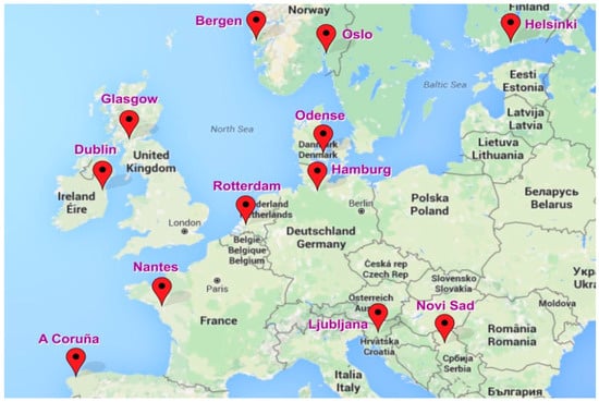
Figure 1.
A map of the main cities studied in the COST Project.
3. Review of Examples of Underground Space Integration in Urban Land-Use Planning in Europe
3.1. Glasgow Case
3.1.1. Issues of Underground Space in Glasgow
Glasgow was the largest city in Scotland in 2014. It has a surface area of 370 km2 and 1.2 million inhabitants.
Its geographical and geological context, combined with its legacy of the mining industry and heavy industry, give rise to a series of problems that affect the development of the city and the urban regeneration of the postindustrial city: instability and subsidence of the soil resulting from the collapse of shallow mining sites, the thickness and composition of glacial units, vulnerability to flooding, and so on [18]. Thus, structural knowledge of the land is one of the fundamental keys to urban planning in Glasgow.
To deal with its underground space, Glasgow developed a three-dimensional (3D) model that fits into the national geological model. The illustration of 3D geometry and an understanding of lithological variability and engineering properties were included in this model. However, planners and geotechnical engineers do not have enough control over the visualization of the 3D geometry of geological units, as they are used to using traditional geological maps [19].
The creation of the model required multiple data sources, including 1:50,000 scale geological maps, digital terrain models created using an airborne radar survey with an elevation reading every five meters, drilling on 11,570 wells in the region, mine plans that provide a vital source of 3D information on multilevel coal-bearing strata, and dissertations and doctoral dissertations that can provide cross-sections and structural information. Recent data were localized (spatially and temporally) and were linked to specific redevelopment projects [20].
The Glasgow model includes bedrock units, unconsolidated sediments, and anthropogenic deposits. Thus, complete 3D models of sediments and bedrock have been created, and a small-scale model of the Clyde River, which runs through central Glasgow, has also been developed for groundwater modeling and contaminant movement [18]. Based on information from 50,000 boreholes, the complex geometry of the shallow aquifer was modeled from the complete geological model of the city.
3.1.2. Integration of Underground Space in Glasgow’s Urban Planning
The Glasgow City Council is involved in the development of a local planning strategic framework that considers the underground land. It deals with the legacy of industry and mining and provides opportunities to identify future energy resources. It also developed, for the first time in Scotland, an underground planning schedule for the city, based in part on 3D modeling [5].
The development of this strategic local planning framework reflects the growing need for proactive approaches to land management [21].
Because there is little groundwater resource data available, a pilot monitoring network has been strategically designed, as a first step, to ensure that groundwater levels are monitored in close proximity and protected from the influence of groundwater resources, rivers, and infiltration systems. Then, a city-wide monitoring network was developed for a better understanding of the general characteristics of the resource.
The goal of this approach is to develop the urban-scale monitoring network, which must adopt existing monitoring boreholes from specific sites and then install a new monitoring infrastructure only in the case of spatial gaps [20]. This network facilitates the sharing and access of data and information [5]. This case study illustrates how a robust conceptual model can be developed to improve the general understanding of urban groundwater resources in case of the absence of significant data on aquifer properties (e.g., groundwater flow patterns and the depth and features of the groundwater).
To manage underground resources and to meet the future legislative requirements of the European Water Framework Directive [20], the city municipality and the Scottish Environmental Protection Agency (SEPA) require a better conceptual understanding of the general characteristics of the urban groundwater resource, such as the general regional pattern of groundwater flow in the city, the depth of the water table, and the seasonal variability of the resource, especially because the need for monitoring in these cities is becoming more and more important due to the increasing use of shallow geothermal energy to meet growing energy needs.
A form of 3D building information modeling (BIM) is being developed to be an effective tool for highlighting such underground data. This urban construction and development project is relevant and can be used to inform the planning and management of the city rather than being just another 3D model [19].
3.2. Hamburg Case
3.2.1. Issues of Urban Underground Space in Hamburg
Hamburg is the second largest city in Germany. It has a surface area of 755 km2 and population of 1.7 million inhabitants (2015).
The main issues faced by the city are flooding problems and the degradation of the quality of the groundwater [22]. Thus, in order to mitigate these problems, the management of public and private water withdrawals is carried out to monitor several challenges, such as the salinization of freshwater resources, increasing the groundwater temperature, and groundwater contamination and depletion. This monitoring uses a variety of maps, available data, and information collected on boreholes. This has resulted in a well-maintained database that is compatible with geographic information systems (GIS) and that is easily interoperable within a national and international framework [20].
Geological data from drilling are stored in the Geological Survey database, and a standardized borehole lithology is used for any new drilled boreholes [5]. These data, combined with other geological and hydrogeological data, were used to construct the 3D geological model of Hamburg. It is a decision support tool for the use of public and domestic groundwater and for the protection of underground resources [22].
3.2.2. Integration of Underground Space in Hamburg’s Urban Planning
Hamburg has large numbers of historical time series to help understand resources and optimize monitoring for future urban planning needs.
To meet current monitoring data needs and reduce operating costs, a program to optimize the groundwater and surface water monitoring network in the city was streamlined from 2000 to 650 sites of quality and quantity and was approved by the groundwater model [22].
Monitoring points were examined based on the quality of construction (boreholes were properly sifted and sieved, and the wellhead had a good seal), age, operating performance, and location in the area aquifer (both spatially and vertically) [5].
In order to develop a coherent and concerted understanding of the aquifer properties in the city, the integration of public and private datasets into the city records and the delineation of the regional groundwater system were key assets. This city is also a reference example of the interaction and cooperation required between several stakeholders. For example, the close collaboration between the State Geological Survey and the water supplier (Hamburg Wasser) has helped to develop a standardized model of the urban groundwater, which has been agreed to by all of the users [22].
3.3. Helsinki Case
3.3.1. Issues of Urban Underground Space in Helsinki
Helsinki is the capital of Finland. It has a population of 1 million inhabitants (2011). It consists of a metropolitan area, including a smaller urban Capital Region, within an area of 716 km2.
In this city, the soft and flat clay areas can cause very difficult construction conditions due to the depth of the support layer of the pillars and the easy settling surface. The level of groundwater, usually very close to the surface, also causes damage to buildings and structures with foundations. To deal with these concerns, the city established a system, managing the elements of the urban underground space. It has thus been able to deal with the various issues raised by the underground environment. In doing so, it has also managed to free valuable land aboveground for more important activities by replacing certain aerial structures with corresponding underground structures [12].
The city of Helsinki has deployed more than 5000 monitoring tubes that provide multiple data and can be easily processed for different models and representations: maps, geotechnical sections, 3D models, etc.
The use of LiDAR (Light Detection and Ranging) scanning technology (both terrestrial and airborne) has resulted in high-resolution point clouds and high-resolution 3D images of the ground surface. Thanks to the combination of geological information with these LiDAR 3D models, new possibilities for interpreting the small-scale features of geological formations have become available [23].
Based on a digital elevation model, a map of quaternary deposits, and soft soil thicknesses, an assessment of the building ability is carried out in order to plan and implement soil improvement. The visualization of these data is done with GIS software, and the input data are converted into an exchange format adapted to the drawing software used by the Geotechnical Division of Helsinki. Thus, the land ability is classified into three main categories: normal soil conditions, demanding conditions, and very demanding conditions [19]. This modeling allowed planners to distinguish soil conditions and to estimate the extent of block areas on soft soils or steep hills.
3.3.2. Integration of Underground Space in Helsinki’s Urban Planning
The law on the use and construction of the territory (2000) presents three types of development plans: the regional plan, the master plan at the city level, and the detailed plan of the individual sites [12].
The city master plan is a land-use zoning map that guides the detailed planning stage and determines land-use changes [5]. In this respect, 30% of the block areas are laid on soft ground [12]. The objective of the master plan revisions is to help planners distinguish areas with normal, demanding, and very demanding soil conditions when optimizing land-use planning activities [23].
As for the detailed plan, it must generally comply with the objectives and policies contained in the master plan at the city level. It is the only plan within the legal sanction that has to establish the development on a site or to change the land-use designation [12]. In addition to these plans, Helsinki has an underground master plan that guarantees the continued use of rock resources in construction and major commercial projects, with 40 new areas reserved as rock resources and 100 new space allocations for future rock construction. It controls the locations, allocations of space, and mutual compatibility of the most recent and largest underground caves, underground tunnel facilities, and tunnels. It also preserves the permanence and functionality of already-built installations. The plan also serves as a guide in the preparation of surface zoning plans. In addition to the space allocations indicated on the master plan map, other constructions are authorized as long as they do not conflict with the main underground functions indicated in the master plan [12].
Thus, Helsinki is the first city in the world to have developed and operated an underground master plan. It is well-suited to underground construction because of the hardness and stability of its bedrock and its proximity to the soil surface. As the urban configuration has become increasingly very dense, the use of rock construction in municipal facilities has allowed for the substitution of aerial structures with corresponding underground structures and thus has freed valuable land above the surface for more important activities [23].
It should also be noted that, in this city, the owner of a plot has control of the corresponding underground area of his plot, although the vertical extent of the property is not specifically defined in the legislation. When interpreting the extent of the plot, the lower limit was restricted to the depth where it can be used technically (in practice, 6 m from the lowest point of the construction lot). Anyone who builds underground facilities must obtain an agreement to use the underground construction site [23].
The city of Helsinki is clearly turning to the use of new technologies and standards, such as BIM and the national standard digital format named “INFRA”. The replacement of two-dimensional (2D) drawings (quaternary maps, cross sections, etc.) is progressively being carried out by 3D visualizations. At present, the largest operators in Finland require the use of the eXtensible Markup Language (XML)-based national exchange format (INFRA model) in their projects to ensure the interoperability of digital information and to motivate the various stakeholders to use BIM. BIM offers the possibility to manage the decentralized maintenance data even in the absence of precise information on numerous pipes and cables buried underground in Helsinki. However, harmonizing 3D datasets from different sources can also reveal problems, such as conflicts between colliding objects [19].
4. Components and Resources of Urban Underground Spaces
The sustainable city must be realized, considering the limited capacities and the richness of its environment. It must ensure a development that guarantees the adequacy of the needs and available resources. In this sense, the principle of multiple uses proposes to supplement the local development strategies at the project scale by reflecting a more general planning of the underground system at the urban scale [24].
Through a systematic analysis of the cases of the cities mentioned above, we have identified the following four families of the urban underground resources: underground land, groundwater, geothermal, and geomaterials.
These items are illustrated in Figure 2.
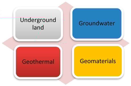
Figure 2.
The resource families of urban underground spaces.
The interaction between these elements requires sustainable planning that promotes their synergy and, therefore, avoids any conflict [25]. It is an open system, because it is in continuous interaction with its environment (exchange of materials and energy). It is dynamic, because flows are governed by environmental complex characteristics and boundary conditions of the system due to the feedback loops that exist at the level of its operation, such as the polluting effects of construction that can have an impact on water management, which, itself, will cause problems of infiltration [26].
This understanding of the underground space as a system makes it possible to identify the uses of its resources, to analyze their interactions, and, consequently, to anticipate the irreversible changes that could result from its exploitation.
4.1. Usages of Underground Space Resource Families
4.1.1. The Use of Underground Land
Underground infrastructure is often used for networks (cables, wastewater, and drainage), transportation (subway, tunnels, and passages), and storage (warehouses, cellars, car parks, and thermal energy). Underground construction frees up surface space for recreational uses or for structural constructions for which natural light is an important criterion (housing, offices) [27].
Underground land uses are described according to the function of the structure, the depth, the method of construction, the geometry, the age, the cost of the construction, and the characteristics of the site. These elements are linked to the geological and hydrogeological conditions and to the urban context in which the infrastructure fits [28].
4.1.2. The Use of Groundwater
As the world’s second largest source of freshwater after glacial waters, groundwater is an important component of the water cycle.
The distribution of the urban groundwater is carried out according to three main destinations [20]:
- The urban distribution network, which is the main network that generally carries most of the drinking water resources;
- Alternative networks, which develop when water resources are limited; and
- Spot captures for individual users (industry, households, etc.).
Groundwater management, in support of sustainable urban development, has improved with a basic understanding of the urban groundwater system and continuous monitoring of groundwater levels [28]. The follow-up is a cyclical process, in which the types of information needed determine the monitoring strategy and design, which allows the data to be collected, analyzed, and translated into useful information. The design of the network supervision is determined by, on the one hand, the urban planning needs and, on the other hand, by the complexity and spatial and temporal variability.
4.1.3. The Use of Geothermal Energy
The exploitation of the geothermal flow and the storage capacity of the underground space are carried out according to three depths [29]:
- Deep geothermal energy: The geothermal flow is operated by open systems at a depth that exceeds 5 km and at a temperature above 100 °C to produce electricity and heat.
- Medium-depth geothermal energy: the exploitation of the geothermal flow is done with an open system to produce heat at depths of 2–2.5 km and temperatures ranging from 60 to 80 °C. Exploitation tests for medium-depth geothermal energy are inconclusive. The exploitation can be done just at lower depths (thermal waters) in case of the presence of a thermal anomaly or from the tunnel drainage water.
- Shallow geothermal energy: Between 0 and 250 m and at temperatures between 10 and 20 °C. The thermal capacity of the subsurface is used to produce heat and cold for air conditioning. A heat pump is coupled with the structures.
Actually, just shallow or shallow structures interact with other subsurface resources in the context of urban underground resource management.
The use of shallow geothermal energy (SGE) offers urban areas a great opportunity to meet growing energy needs (heating and cooling) in the future. It will increase the resilience of cities by reducing their reliance on limited hydrocarbon energy resources.
4.1.4. The Use of Geomaterials
Cities depend on geomaterials that increasingly come from distant areas because of their scarcity. However, the transportation of these materials has a very high economic and environmental cost.
Therefore, to solve this constraint while meeting the objectives of environmental protection, the recycling of excavation materials is of real interest for use in cities [30].
The two main uses for geomaterials in urban areas are as follows:
- Mineral building materials, such as concrete and asphalt aggregates; and
- Backfill materials for road and rail infrastructure, excavation work, and site alterations.
4.2. Interactions of the Uses of Urban Underground Space Resources
The interactions of the uses of urban underground spaces play a decisive role in developing a sustainable management strategy [27]. These interactions are studied in pairs of resources based on the description of the uses of resources.
In most cases, these interactions are in conflict, and the use of a resource often tends to impact negatively the use of other types of resources in underground spaces [20]. This is the case for the impact of groundwater uses on the underground space if the infiltration of groundwater arises in cities where a rebound of the water table occurs [28].
The preservation of the infrastructure then requires a massive amount of pumping in the aquifers to lower the water table. This impact may also result in subsidence and uplift that may be of a different intensity depending on the field parameters and on the extent of their overexploitation or on the corrosion of the infrastructure and the deterioration of the structures in the case of anthropogenic pollutants mobilization. This can have an impact on the quality of drinking water and on the infrastructure in contact with the water table.
There can also be hydrogeological competition when the impact of the underground constructions causes a lowering of phreatic levels by pumping or drainage, a dam effect when the underground structures entering the aquifer change the flow conditions and create a barrier to this flow, hydraulic short circuits when two superimposed aquifers are crossed by the same structure, or pollution by injection materials that are grouts based on cement, silicate gel, or synthetic resin that can migrate over large volumes during the construction of underground structures in aquifers [28].
To ensure the use of upstream groundwater resources and reduce the downstream impacts of their use in some parts of the city, redevelopment plans must be understood and incorporated into land-use planning [24].
5. Modeling of Underground Space Resources and Their Integration into Urban Land-Use Planning
The growing global and systematic knowledge of underground spaces and the multitude of uses of underground resources necessitate the representation and integration of such spaces and resources into strategies of land-use development. Certainly, this requires the transformation of the data into synthetic and coherent information that can be accessible to all actors.
As a result, urban mapping, linked to 3D geological modeling and artificial land modeling, focuses on the management of resources (underground land, groundwater, geothermal, and geomaterials) for the best use and consequently for their integration into planning documents.
5.1. Three-Dimensional (3D) Urban Geological Models
Depending on the needs of the planning and the use of the resources, underground specialists must adapt the process of the modeling. The demand side and the supply side must together define in the planning hierarchy the type of information needed at the right time and place [31]. Planners in their respective cities may identify geological issues that may be specific to each city. These problems can be caused at least in part by the nature of such underground spaces, such as in the case of Glasgow [18].
To control and monitor the urban issues relating to the underground component, the models make use of several sources of input data, including geological descriptions, geotechnical characteristics of boreholes, geotechnical tests, hydrological and hydrogeological data, geophysical data, historical and archaeological data, topography, soil maps, mine and quarry plans, construction drawings, and data regarding underground structures.
All these data sources must be of good quality and must be collected, digitized, and standardized before being used in a 3D model. Some difficulties related to the use of input data from various sources may arise, such as the difference in scales of representation, the lack of up-to-date and good data, and the lack of metadata describing the nature of the data, as well as the lack of semantic and geometric heterogeneity of the data, making interoperability, and the exchange and the combination of geological data with other underground and aerial data, very laborious. This makes the task of compiling urban data for 3D urban modeling more and more constraining [19].
There are two main methods that are currently used to represent 3D geological models:
- Layer modeling: It is the creation of a set of surfaces representing generally stratigraphic geological changes and other elements, such as faults. It is the most used, although it has limitations because of the creation time of the model and the difficulty of illustrating several lithologies [32]. For example, the Dutch spatial planning model has three conceptual layers, namely the occupancy layer with buildings and other major land-use functions, the network layer representing the transport and utility infrastructure networks, and the underground layer with underground constructions, such as tunnels and mines [5].
- Stochastic modeling: This approach uses geostatistical techniques to determine the probabilities of some properties, such as lithology or hydraulic connectivity in 3D spaces. To do this, a 3D grid, in which the simulation can be fulfilled, must be created.
In urban geological models, because of unequal data classifications and distribution problems, lithological modeling is not usually easy to replicate. At first, stratigraphic layers are created. Subsequently, the 3D grid is produced, and the properties are modeled stochastically [33].
5.2. Models of Artificial Land
Geotechnical activities, geothermal facilities, and suburban infrastructures alter the physical properties of the upper parts of the underground space and involve existing tillage. This necessarily leads to general geotechnical problems, such as subsidence, hence the increased need to map the current structure and properties of the subsurface, anthropogenic layers, and pre-anthropogenic layers.
Because the boundaries of cities are expanding, the properties of artificial layers change continuously. This shows the need for dynamic models of the urban underground to model future artificial changes in the subsurface. This, then, requires integration into the modeling and the dynamics of time (4D) and space (5D) that deserve to be studied to capture the evolution and changes operating in the urban underground [19].
As for the multiple input data of the artificial land models (boreholes, excavation data, water level and geophysical gauges, underground infrastructures, pipes, cables, underground building parts, maps of historical sites, etc.), they will be necessary but at a very dense level, because the artificial structures and the suburban infrastructure are generally in decimeters, at the meter scale. This means that the model will have a high level of detail (small scale) and the uncertainties will be greater than in the modeling of the natural deposits [34].
In order to map the artificial layers in the urban underground space, it is important to focus on the needs of the final user and to assess whether the existing data can produce the details of the required model. This is the progressive approach that is commonly used for artificial soil mapping. It includes the initial phase of the model review, the data evaluation phase, the data collection phase, the modeling phase, the model construction phase, and the last phase of updating.
The lack of precise and detailed data, the complexity of the underground space, and the geometry and parameterization of anthropogenic deposits are all specific challenges for the construction of an urban 3D model including artificial soil in urban areas [35].
The visualization of the results of the urban underground model depends on the use of the illustration, the availability of data, and the format of the other combined data sources. It varies between 2D maps, cross-sections reflecting lithological units, or 3D models that can be edited in 2D or 3D formats.
Recently, geological visualization techniques have improved with high-resolution LiDAR terrain models (radiation detection and telemetry). LiDAR can scan and present the details of the unrecognized land surfaces more precisely than traditional methods. High-resolution elevation data also increase the value of surface deposition maps and makes them easier to interpret [19].
6. Usage and Modeling of Underground Space in Casablanca
6.1. Presentation of the Study Area (Casablanca)
6.1.1. Geographic and Socio-Economic Context
The Casablanca region is located in the center-west of Morocco on the plain of Chaouia and about 80 km south of the administrative capital of Morocco (Rabat). Spread on the Atlantic coast for nearly 50 km, it is the main economic, financial, and urban center of the country. Its total surface area is 1615 km2 or 0.16% of the national territory [36]. Figure 3 shows the location of Casablanca.
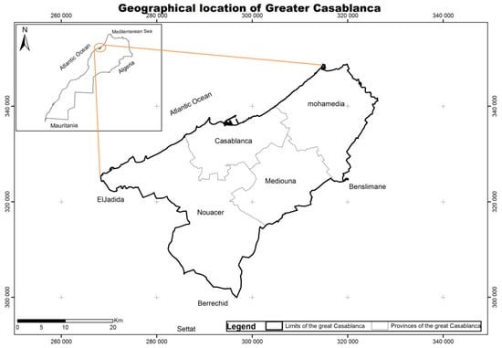
Figure 3.
The geographical location of Casablanca.
The population of the region is approximately 4,270,750 inhabitants, according to the general census of the population of 2014. It encompasses about 12.6% of the population of Morocco. The city of Casablanca covers 386.14 km2 and comprises 3,359,818 inhabitants [37]. It contributes 11.4% of the national employment, and the service sector is the largest provider of jobs in the region, amounting to 64.5% of the total number of jobs. The industry and crafts sector supplies 26.3% of jobs, and the rest is divided between the buildings and public works sector (7.6%) and the agriculture, forestry, and fishing sector (1.3%) [38].
Because of rapid urban growth, major projects have been created and implemented without integrating urban transportation, which is becoming a key issue in this service and industry region [39]. The number of commuter trips within the city is 11 million per day. It will rise, according to 2030 estimates, to more than 13–15 million daily trips [40].
The Casablanca region has the largest airport and port in the country. It is also the nerve center of the national highway and rail transport system [36]. With respect to urban transportation, the city of Casablanca is the second Moroccan city to set up a tramway network that started in 2012. Two other lines are under construction, and public transportation lines with high-level buses are being planned [41].
6.1.2. Horizontal Sprawl of the Urban Planning in Casablanca
With a very high population density, Casablanca is looking for an answer to the demographic explosion that is pushing the limits of the center of the city towards the peripheries, especially as its core becomes increasingly overpopulated with 15,000 inhabitants per sq. km (2014). The urban sprawl is facilitated by the high number of private cars and public transportation (even if it is less prominent in certain peripheries), but also due to the suburbanization of jobs (industries, commerce, leisure, and logistical platforms) developed on larger and cheaper lands outside of the city center.
Certainly, the inhabitants seek to settle on the periphery of the city center not only because of the existence of (available and cheap) land in these more distant zones, but also because of socio-economic factors [36]. In addition to all these factors, public aid and development policies have promoted this urban expansion as a result of certain major projects, namely the creation of new cities or the resettlement of slums.
We evaluated this urban sprawl issue through a diachronic study spread over time (in 1984, 1999, and 2017) [42] to determine the successive enlargements of the urban boundaries through the object-oriented classification of satellite images of Landsat 7 (TM: Thematic Mapper), (ETM+: Enhanced Thematic Mapper Plus) and Landsat 8 (OLI: Operational Land Imager). The classification performance was evaluated through the Kappa index, which is 0.67.
Thus, we had mapped urbanized areas and analyzed the territorial dynamics of the urban development. Figure 4 illustrates the urban expansion (built zones) map by combining maps of urbanized areas in 1984, 1999, and 2017.
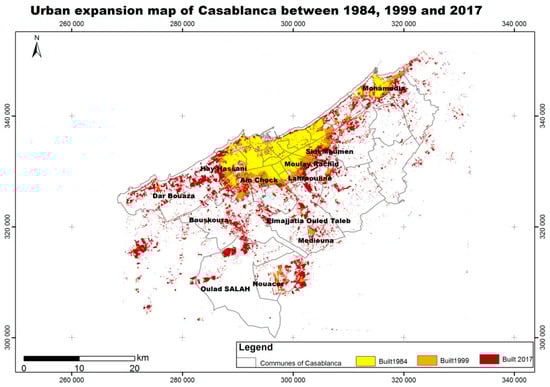
Figure 4.
The urban expansion map of Casablanca in 1984, 1999, and 2017.
The speed of urban expansion during each period of 1984–1999 and 1999–2017 was calculated using the following formula:
where UAi is the building area of the initial year, UAn+i is the building area of the last year of the period, and TAn+i is the total of the years of the period.
UES = (UAn+i − UAi)/TAn+i,
The statistics of the urban expansion of Casablanca are shown in Table 1.

Table 1.
Urban expansion statistics of Casablanca.
The spatio-temporal urban sprawl was initially axial (along El Jadida, Nouacer, Médiouna, and especially along the coast towards Mohamedia) and then later radial towards the peripheries, especially in the southeast (Sidi Moumen, Moulay Rachid, and Lahraouyine), and towards the southwest (Hay Hassani, Ain Chock, Bouskoura, and Dar Bouaza), where urbanized areas are gradually becoming denser with time.
In addition, three urban cores emerged and spread. These are TitMellil (in Lahraouiyine towards Tit Mellil), Mediouna (along the Casablanca–Mediouna road), and Nouacer (more precisely Bouskoura along the Casablanca–Nouaceur road, as well as Dar Bouaza, on three axes parallel to the coastline) [43].
It should also be noted that, in 1984, building in the province of Mediouna was non-existent but was experiencing a slight growth (Figure 4), which left this peripheral center cramped, especially because of the surrounding areas, which were not restructured. As for the municipality of Oulad Saleh, it includes one of the largest quantities of agricultural lands in the region. It has kept, therefore, its rural character, which has remained dominant with light and diffuse urbanization.
Overall, this illustrated urban dynamic has changed from mono-centrism to polycentrism due mainly to the efforts of the political and administrative actions of the stockholders through the realization of large social housing operations aimed at the “eradication” of some large slums [44].
6.2. Urban Underground Space of Casablanca
6.2.1. Geological Context
Geologically, the study area belongs to the coastal tableland or Low North Atlantic Plateau, characterized by an almost horizontal Neogene and Quaternary blanket that covers the metamorphosed Paleozoic. The Cambrian age base (quartzite and schist) is anticlinal, flattened, and covered by a few thick tens of meters of Miocene of ancient Quaternary, presented by marls, ooze, and some sand that is more or less calcified [45].
It is separated from the central tableland by a former accident of direction NNE–SSW. Not active today, it is Hercynian faults that outcrop particularly in the valleys of El Malleh and N’fifikh and around Ain Harrouda [46]. Limestone and Cretaceous limestone marl have been conserved just locally in the El Malleh river and Casablanca [47].
The geological map of the study area, produced by combining different existing maps, is illustrated in Figure 5.
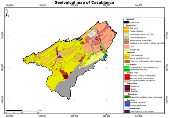
Figure 5.
A geological map of Casablanca.
The morphology of the study area is characterized by a system of great strands called a “quaternary”. It is a system of dune cords and interdunal furrows almost parallel to the present coast. These dunes, covered with red sands, are marked by the asymmetry of their slopes of Aeolian origin. Along the coast, the system of consolidated dune ridges is separated from the present shoreline by a longitudinal “oulja” trough, limited on the mainland side by the Ouljian cliff [46].
Each morphological unit is associated with intertidal to supratidal and dune deposits characteristic of regressive sequences, alteration facies (karsts, paleosols), and reworking. The staging of these platforms can be related to the major stages of high latitude ice-freeing in the northern hemisphere and the corresponding lowering of the level of the global ocean [48].
Miocene deposits exist locally in the form of thin limestone sandstone veneers and fine molassic sand. Above are the plio-quaternary formations in the form of marine terraces [49].
The deposits of these marine terraces are generally composed from bottom to top by lumachell conglomerates, surmounted by marine beach calcarenite, which progressively progress to dune calcarenite, intercalated locally by rusty continental spreading and often altered in pulverulent limestone, crowned by various limestone crusts [46]. For the Paleozoic formations, they show sandstones, schists, and limestone in several stratigraphic layers [47].
On the west of the Nefifikh river, calcarenite appears in small cliffs, and the Paleozoic spur of sandstone and Cambrian quartzite of the cape of Mohamedia advances at the sea in the same way as that of El-Hank in Casablanca.
In addition, in the east of Casablanca, the deposits of the oldest sea (Acadian to the Middle Cambrian) are outcropping in the form of green schists followed by quartzite, which end the Cambrian cycle [47].
The geotechnical study of the various deposits of the consolidated dune cordon of the Casablanca–Mohamedia littoral revealed that they have a bad to average quality and a low resistance to the compression. On the other hand, that of the Acadian deposits has shown that they have very low porosity and very good quality and resistance, especially the quartzite deposits. This suggests that any underground structure or infrastructure is buildable on these different types of soil. The geology of Casablanca is not a limiting factor for the use of its subsurface as an underground space, because everything is geo-technically constructible. It is the expensive implementation that usually poses a problem, especially because the foundations vary according to the type of soil, namely the classical superficial foundations (base plate or base) and semi-deep foundations (wells) or deep foundations (piles or micro-piles) in the case where the resistant soil is deeper when there is a risk of droop.
6.2.2. Resources of the Underground Space
The sustainable development of the study area requires an understanding of the underground space and an identification of the four types of underground resources, namely ground land, groundwater, geomaterials, and geothermal energy.
- Ground land: The first works in the subsoil of Casablanca were conducted for the construction of the port’s quay in 1907 and then its extension in 1913 [50,51]. Low interest was given to the use of the subsoil with the exception of a few tunnels for networks or transportation or a few buildings for storage (cellar, parking). The urban expansion was horizontal and did not consider the waste of valuable land above the surface. The construction of an underground structure depends on the geological and hydrogeological conditions and the urban context in which the infrastructure fits. In practice, the evaluation of the technologies and the means to be implemented to carry out the project is performed by professionals on the basis of geotechnical and geological studies that present the quantitative parameters (direction of dip, mechanical parameters, permeability, etc.) and the qualitative parameters (particle size heterogeneity, heterogeneity of geological formations, etc.) and also on the basis of their expertise.
- Groundwater: The infiltrated rainwater accumulates or transits into groundwater reservoirs. The study area has two water tables and some streams, as shown in Figure 6. The first is the water table of the coastal Chaouia, which extends over 1.200 km² of the coastal strip and is 20 km wide. It is characterized by very low piezometric levels, varying between 8 and 20 m, medium to low permeability over its entire extent, and flows per structure generally not exceeding 4 L/s. It has a potential of 52 million m3 [44]. Of a heterogeneous nature, it is contained at once in the calcareous formations of the plio-quaternary, in the Cenomanian marnocalcaries, and in the primary schistose, sandstone, and quartzitic terrains [52].
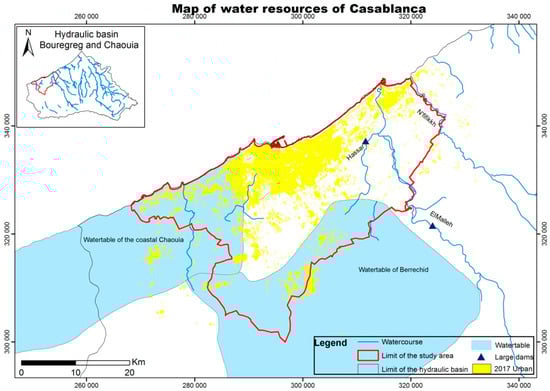 Figure 6. A map of water resources of Casablanca.
The second is the Berrechid groundwater, it has a total area of 1.500 km2. It is characterized by shallow depths ranging from 10 to 20 m and continuous flows up to 30 L/s.
Overall, the study area is characterized by the absence of geological formations susceptible to containing significant water bodies, because the texture and the structure of the grounds do not favor the infiltration and the underground accumulation of the rainwater [53].
These groundwater resources are exposed to various risks, as is the case in the city of Mohammedia, where the salinity and nitrate content are higher compared to the waters of the other sites. These risks are favored by certain factors, such as the shallow depth, the speed of infiltration, the proximity of public landfills, and industrial zones [43,52].
The water of the Berrechid aquifer experiences a continuous deterioration in both the quantity and quality aspect following the heavy exploitation of the aquifer to meet the needs of irrigation, industry, and drinking water supply [44,54]. Overexploitation is 20 hm3/year [53]. Similarly, the Chaouia-coastal water table, which has very high mineralization, has problems with nitrate pollution and marine intrusions [54]. The deficit recorded at this level is estimated at 10 million m3 [53].
- Geomaterials: The development of mining activities is favored by a varied geological structure and its concentration in ores. The mineral potential of the Casablanca region, including the study area, is limited, and it is restricted to antimony, salt, and iron. However, the extraction and exploitation of certain ores is stalled because of their low economic return [44]. As for the extraction of stone and aggregates, many quarries began at several points in the plio-pleistocene marine and dune formations consolidated into storied cords [55].
- Geothermal energy: In the western Morocco basin, the geothermal gradient fluctuates between 19 °C/km and 34 °C/km. These low values are observed in the tectonically stable zones, such as in the case of the western tableland, including our study area [56,57].
There is little interest in geothermal resources in this region, unlike the area of northeastern Morocco, which is promising, according to the geothermal potential [58].
6.3. Underground Space Uses in Casablanca
Casablanca city is more often using underground space for the management of urban development. In the past, such use was focused mainly on the installation of the utilities (drinking water, sanitation, electricity, and telecommunications) and particularly at very small depths. Today, several projects have been implemented in the underground space (hoppers, car parks, etc.). The main purpose is to solve traffic problems, which are a major issue in the city. Although these projects are often localized in space, other projects with a larger scope are in the study or in the implementation phase.
Two large underground projects have marked the city of Casablanca. The first is the subway project (Metro project). The idea emerged in the 1970s but has never been realized. The second is the Bouskoura super collector project, which was built in the underground to deal with the floods affecting the western part of the city of Casablanca. These two projects, with two completely different outcomes, represent concrete examples of the use of urban spaces in Casablanca.
6.3.1. Subway Project: An Example of Failure
The idea of equipping Casablanca with a subway system started in the 1970s, and feasibility studies of the project were subsequently launched. In the mid-1980s, an announcement of the abandonment of the idea of an underground subway was made in favor of an aerial subway because of technical problems, and the study was entrusted to the Japanese. Since then, other studies have been carried out, the last of which date back to 2000 and 2007.
In 2000, a set of consortia of international companies presented to city decision-makers the results of their feasibility studies conducted based on the route defined by the Japanese study of the 1980s. Each offer then proposed an implementation scenario with a preliminary estimate of the project cost. As no follow-up was given to these studies, this effectively put an end to the long debate about whether the geological structure and the water table that passes through Casablanca prevent the feasibility of an underground subway project. The debate on the subway project would be relaunched on the occasion of the launch of the Urban Travel Plan (PDU) of Casablanca. The results of this plan, announced in 2007, stipulated the implementation of an integrated transportation system made up of four tramway lines, a subway line, and a regional express network-type railway line [40]. The subway line was initially designed to link the Bourgone district to Hay Moulay Rachid for a total distance of 21 km (Figure 7). The comparison was then made between an aerial and an underground subway. Studies conducted on this issue and focusing on the cost component have shown that the cost of the underground option exceeds that of the aerial alternative by more than 70% [59]. The underground metro was deemed too expensive, and the choice was made to construct an aerial subway.
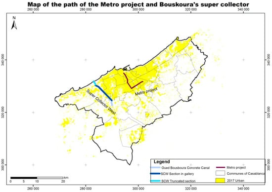
Figure 7.
A map of the path of the Metro project and Bouskoura’s super collector.
In 2013, the topographic and geotechnical studies of the aerial subway project, focused on 15 km, were launched; however, this option was also abandoned in 2014 due to the high cost of the project and the lack of funding. The idea of the subway project was ultimately rejected, and it was replaced by the introduction of a tramway [59].
6.3.2. Underground Super Collector Project: An Example of Success
The risk of flooding is the main natural risk for the Casablanca region due to its construction on rivers [40]. The example of the Bouskoura stream, crossing the western part of the city, is a concrete illustration of this risk, which has caused enormous human and material damage over time. The recurring overflow of this river generates the flooding of several neighborhoods and sensitive establishments, and it forced the city to think about the installation of a super underground collector to convey the water directly to the sea, passing a very dense urban area of a distance of more than 5.5 km [60]. This hydraulic tunnel, launched in 2014 and completed in 2018, also collects rainwater from crossed watersheds.
The Bouskoura tunnel was dug by a specific tunnel-boring machine of 6.5 m in diameter and 87 m in length (Figure 8). The drilling was carried out at a depth of 12–40 m and crossed several geological configurations, namely the Cretaceous limestone, the psammites, and the quartzite [60].
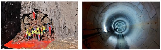
Figure 8.
Construction works of the Bouskoura underground super collector (Source: Casa Amenagement).
This flood protection structure of the Bouskoura stream has three distinct parts: an open-air upstream canal of 3 km long, the 5.5-km tunnel including 800 m of water table, and the downstream trench backfilled with a length of 700 m (Figure 5, figure of the path mentioned above in the subway project section). Before the underground digging began, a building inspection system was introduced, as the tunnel layout was developed below a very dense urban area. This allowed for the control of the movements of the ground and the buildings during all the periods of the development [60].
The success of this first gigantic underground project in Casablanca has demonstrated the possibility of the use of the urban underground space to solve some major issues, such as flooding. It proved that the subsurface of Casablanca does not present insurmountable technical or geological problems and that the major obstacle to the exploitation of this space is the cost factor, which can be cushioned in the future with technological development and techniques of digging and adopting a long-term problem-solving strategy.
6.4. Proposal for an Integrated Model of Urban Underground Space Use in Casablanca
6.4.1. Planning and Management of Urban Land-Use Planning in Casablanca
The purpose of urban planning is to plan and organize how a territory will evolve at the city level. To do this, urban planning relies on a set of regulatory documents, called planning documents, developed for time and space scales. Thus, the agglomeration of Casablanca has a master plan of urban development that was established in 2008 and covers the entire study area (Figure 9).
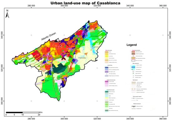
Figure 9.
The urban land-use map of Casablanca.
On a finer spatial scale, urban land-use planning is managed through “development plans” that fix the land uses at the level of the various districts, while respecting the provisions of the master plan. The development plans define the zones of habitat, those dedicated to green space, those of equipment, and the roads, as well as the zones where construction is prohibited, all within a horizon of 10 years. A derogation procedure to the applicability of these documents has been introduced in the planning process to make urban management more flexible and to meet the needs and constraints not foreseen by these plans. However, the use of this procedure in Casablanca is very widespread given the economic and demographic development of the city and the pressure exerted on the land use.
The urban sprawl in the city’s oil spot, highlighted in Figure 10, is delimited in the new urban land-use map of 2030 by opening new spaces to urbanization in peripheral municipalities. The choice of extension sites for urbanization takes into consideration the natural risks that have been analyzed and mapped, while protecting sensitive and fragile areas (wadi beds, the coastal strip, and resources such as deposits).
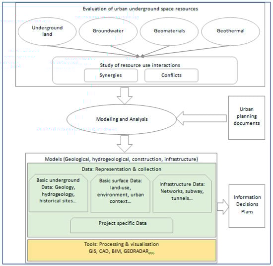
Figure 10.
The structure of Sub-Urban Information Modeling (SURBIM).
The trend is towards the development of intermediate housing and reducing the density of very high-density neighborhoods, such as the medina. On the other hand, the goal set out in the new SDAU: Master plan of urban planning for informal or precarious settlement areas is to completely eradicate unhealthy housing and slums by 2030.
As major structural projects, we find the development of clusters of economic activities, such as the development of the former Aerodrome Anfa, the business park of Nouaceur, and two ports are being extended.
Nevertheless, the overall and sectoral assessment shows a degree of achievement that is well-below the forecasts shown (40% of the rate of completion of development routes, for example) [61].
The reasons for the mixed assessment are multiple: legal, institutional, land, and financial. The most important element is the absence of a governance of implementation and a coordination structure. This leads public actors to act in a dispersed manner.
Normally, planning consists of plans and the institutions that realize and implement such plans. However, in Casablanca, the specific legal rules (urban planning documents) are the only components present in the state framework. Behind the pluralism of this urban planning between public and private actors, there is a heavy state centralism that seems to have been weakening for some time (the development of the SDAU of 2010). This regulatory urban planning cannot properly implement urban development, leading to the need for strategic planning that places a special emphasis on civil society.
At present, none of these urban planning documents in Casablanca consider underground spaces. They focus mainly on the horizontal distribution of space, and, in some cases, the vertical dimension pointing upwards. However, the city confronts a series of risks, some of which can only be dealt with and resolved through the consideration of underground spaces.
The risk of flooding is a concrete example, as just presented above in the case of the Bouskoura stream. Groundwater is another problem in the city, given the overexploitation of these resources and the continued decline of groundwater levels. The city is also at risk of building collapse in some areas, such as in the old medina or in old quarries and abandoned mines.
The prehistoric heritage of the city must also be taken into consideration. It represents a rich geological heritage for its sequence of quaternary deposits developed particularly in some major sites, such as the quarries of Sidi Abderrahmane (0.2–0.6 million years (Ma)), Thomas (0.5/1 Ma), the Ahl Al Oughlam site (2.5 Ma), and Rhinoceros cave in Oulad Hamida (0.6/1 Ma). The safeguarding of these sites and their scientific and cultural enhancement are essential [51].
Thus, in order to ensure the sustainable urban development of Casablanca, all the components of space (horizontal and vertical in both directions) must be taken into account in order to provide the optimal and sustainable solutions and responses to the different problems caused by urban development and demographic growth, which constantly put great pressure on the urban territory and its resources.
6.4.2. Towards a Model Integrating the Underground Space in Urban Land-Use Planning
A systemic approach to the underground space and its resources makes it possible to better understand the dynamics of the underground system and, thus, to make a diagnosis of the natural environment and the potential use of each resource, including their potential for multiple uses. It is an approach that helps, according to the needs of the city, to develop the usage of the underground space within the land management projects.
The starting point of this approach is the mastering of information. Indeed, to plan and manage the space according to its various dimensions, it is essential to have data on all these components. The data must be complete, reliable, and up-to-date. However, concerning urban issues, the actors are multiple, and the data are often dispersed among these contributors, who exploit them according to different strategies and tools. The sharing of information and the standardization of data are, therefore, fundamental elements for the sustainable and optimal management of the territory [62].
Considering that the underground component requires information on geology, hydrogeology, underground resources, geothermal energy, geomaterials, underground infrastructure, etc., interactions between pairs of these elements must also be studied and structured as derived information that can improve the knowledge and the understanding of this environment. This data and knowledge must then be collected and integrated into a framework where the procedures and methods for processing and managing this data will also be implemented.
For this purpose, and in order to integrate the underground component into the urban planning process of Casablanca, we propose the model illustrated in Figure 10, which describes the different elements of the underground space and their interactions, as well as the analysis and modeling of the corresponding information. This model, called “Sub-Urban Information Modeling” (SURBIM), represents all of the entities of Casablanca’s urban underground, as well as their physical implementation through representative data that are grouped and shared in a spatial database updated by the actors according to the scope of intervention of each.
The geological model presents the geological context of the study area. It provides a mapping of the geological formations at different scales [62] and describes the geological and geotechnical properties of the sites. Other information can be attached, such as field surveys and stratigraphic sections.
The hydrogeological model is integrated into the geological model. It is used to interpret the evolution of hydrogeological conditions over time and mainly in the aquifers and the formations with which they interact. It provides a mapping of the extent of the aquifers and the piezometric level of water, as well as the description of boreholes and wells.
The construction model describes the environment of the land use. It will be used for the study of the problems of housing collapse or for the construction of underground land (Level-1, Level-2, or even more) buildings that are beginning to spread in Casablanca for the sake of optimization and valorization of land that is very expensive. This model can be reconstructed in 3D using BIM techniques, such as in the Glasgow and Helsinki models.
The infrastructure model targets to help set up infrastructure projects, such as transportation, sanitation, rainwater drainage, and the passage of the medium- and high-voltage electricity network. The integration of these infrastructures into the urban underground information system will make it possible to coordinate the field interventions, avoid accidents and conflicts, and will also reduce the costs of moving underground networks that operate each time a new project is implemented (e.g., the tramway).
In addition to the underground database, the urban planning documents, such as the urban development plan of Casablanca, will also be integrated into the model to combine both the surface and subsurface information and to take into consideration the synergies and the conflicts between these two spaces.
The model will be based on a set of tools. The main one is the GIS that will serve as a basic tool for processing, manipulating, and visualizing data. Other tools can also be added into the framework, such as BIM, computer aided design (CAD), or Georadar (a tool for studying and understanding the subsurface geometry and managing the underground urban infrastructure, such as pipe detection or auscultation of concrete works).
The target of the SURBIM model is to produce and consolidate all types of data regarding the underground space in order to set up a policy framework that should deliver the information and plans regarding this space and guide the stakeholders’ decisions. Otherwise, the use of this space would be tenuous and unsustainable. Probable conflict over the increased use of underground space could potentially increase pressure on this valuable resource [63]. This decision-making framework helps maintain a balance between exploitation and preservation. In the case of exploitation, another balance must be found between the four underground resources [2].
In Morocco, it becomes necessary to regulate the use of underground spaces in a global and non-fractional way, such as by certain laws related to mines or the extraction of groundwater.
The development of the underground space in a sustainable way can be done by reserving the space for future uses, as in the case of Helsinki (various tunnels and underground installations have been created over the years). The reason this could be achieved in Helsinki is that the soil property below the surface is public, the companies involved in the various tunnels and underground facilities are public, and the geology is made up of competent rocks.
The major challenge for town planners is not only the understanding of geology but also the regulation of land ownership for the exploitation of the subsurface. Also, an in-depth dialogue with all of the stakeholders to create a vision and strategy of the best way to achieve the future of the urban underground is important. The development of the underground space utilization requires regulation and management during its implementation [2].
The proposed SURBIM model is intended as an integrated framework in which the various elements relating to the urban underground space of Casablanca will be grouped together. It will enable the various actors to benefit from the data and the knowledge of others, to share the costs of data acquisition and exploitation, and to study all the issues and questions related to this environment in a coherent, integrated, and multidimensional context.
Thus, the use of this space to implement the part of the buildings or infrastructure to relieve the pressure on the urban surface can be done in an enlightened and rapid way because of the control of the information regarding the underground, its interactions, and its reaction with the surface. Similarly, the exploitation of underground resources (water, energy, and materials) can be done by respecting the requirements of sustainable urban development and by providing answers to the various natural and anthropogenic risks that urban agglomerations face.
7. Conclusions
With population growth and economic development, cities are facing enormous challenges with respect to sustainable development. They must meet the needs of socio-economic growth while preserving the environment. These urban challenges are developing on both a horizontal and a vertical scale, affecting both the top and the bottom of the urban surface. Thus, the urban underground space is being increasingly utilized to meet these needs and the requirements of development.
The purpose of this study was to analyze the reasons for using urban underground spaces and the related issues in urban land-use planning, to determine the components and resources of such spaces, to investigate how underground spaces have been integrated into urban planning, and to study the possibilities of utilizing this space in the city of Casablanca.
Thus, an analysis of cases of the use of urban underground spaces in several European cities was realized by examining the components, resources, and modeling of suburban spaces.
A study of the characteristics of the urban underground of Casablanca was carried out on several levels and resulted in the proposal of a model called “Sub-Urban Information Modeling (SURBIM)”. Its objective is to gather all the data and knowledge related to this space in an integrated platform, shared and updated in order to facilitate the understanding of the elements of this space and their interactions, as well as to ensure a rational and efficient use of its resources.
The development and the application of this model can be carried out on the basis of the data and the information identified in the framework of this study (geology, groundwater, underground infrastructures, models, etc.) by using a sample of geographical data in a geographic information system.
Author Contributions
Conceptualization, A.F., M.H., and M.Z.; data curation, M.H.; methodology, A.F., M.H.; formal analysis, A.F. and M.H.; software, M.H.; validation, A.F. and M.H.; investigation, A.F. and M.Z.; resources, M.H. and A.F.; writing—original draft preparation, M.Z.; writing—review and editing, A.F. and M.Z.; visualization, A.F. and M.H.; supervision, A.F. and M.H.; project administration, A.F. and M.Z.; funding acquisition, M.Z.
Funding
This research received no external funding.
Acknowledgments
I would like to thank all of the professors and organizations who contributed to donations and the collection of the database.
Conflicts of Interest
The authors declare no conflict of interest.
References
- Chow, F.C.; Paul, T.; Vähäaho, I.T.; Sellberg, B.; Lemos, L.J.L. Hidden Aspects of Urban Planning: Utilisation of Underground Space. In Proceedings of the 2nd International Conference on Soil Structure Interaction in Urban Civil Engineering, Zurich, Switzerland, 7–8 March 2002; pp. 1–7. [Google Scholar]
- Admiraal, H.; Cornaro, A. Why underground space should be included in urban planning policy—And how this will enhance an urban underground future. Tunn. Undergr. Space Technol. 2016, 55, 214–220. [Google Scholar] [CrossRef]
- Gogu, C.R.; Gaitanaru, D.; Boukhemacha, M.A.; Serpescu, I.; Litescu, L.; Zaharia, V.; Mihailovici, M.J. Urban hydrogeology studies in Bucharest City, Romania. Procedia Eng. 2017, 209, 135–142. [Google Scholar] [CrossRef]
- Jamalludin, N.A.; Zaini, F.; Hussin, K. Development of Underground Land in Malaysia: The Need for Master Plan of Urban Underground Land Development. Procedia-Soc. Behav. Sci. 2016, 219, 394–400. [Google Scholar] [CrossRef]
- Van Der Meulen, M.J.; Diarmad, S.; Campbell, G.; Lawrence, D.J.; Lois Gonzalez, R.C.; Van Campenhout, I.P.A.M. Out of Sight Out of Mind? Considering the Subsurface in Urban Planning—State of the Art; COST TU1206 Sub-Urban Report TU1206-WG1-001; NGU (Geological Survey of Norway): Trondheim, Norway, 2016. [Google Scholar]
- Ronka, K. Underground space in land-use planning. Tunn. Undergr. Space Technol. 1998, 13, 39–49. [Google Scholar] [CrossRef]
- Zaini, F.B.; Hussin, K.B.; Arrifin, A.B.; Ali, N.B. The Future Use of Underground Space in Malaysia: A Literature Review. Int. J. Estate Stud. 2012, 7, 16–27. Available online: https://www.researchgate.net/publication/261667011 (accessed on 9 November 2018).
- United Nations. Post-2015 Sustainable Development Agenda; United Nations Development Program: New York, NY, USA, 2015; Available online: http://www.undp.org/content/undp/en/home/mdgoverview/post-2015-development-agenda.html (accessed on 9 November 2018).
- Pratesi, F.; Tapete, D.; Del Ventisette, C.; Moretti, S. Mapping interactions between geology, subsurface resource exploitation and urban development in transforming cities using InSAR Persistent Scatterers: Two decades of change in Florence, Italy. Appl. Geogr. 2016, 77, 20–37. [Google Scholar] [CrossRef]
- Ndaw, M.F. Study on valuing the potential of ICT in the water sector, Sanitation and Hygiene. Summary of Conclusions and Recommendations; Public Disclosure Authorized Ouagadougou 01. Burkina Faso, 2015. Available online: http://documents.worldbank.org/curated/en/838971468188667235/pdf/100297-WSP-FRENCH-Box393228B-PUBLIC.pdf (accessed on 9 November 2018).
- De Pas, A. The BRGM abroad: Geosciences at the service of the States, Press file. BRGM Geosci. Sustain. Land 2016, 1–7. Available online: http://www.brgm.fr/sites/default/files/dossier_presse_brgm_igc2016.pdf (accessed on 9 November 2018).
- Vahaaho, I. Underground resources and master plan in Helsinki. Adv. Undergr. Space Dev. 2013, 1528–1539. [Google Scholar] [CrossRef]
- Seither, A.; Ganerød, G.V.; De Beer, H.; Melle, T.; Eriksson, I. Bergen; COST TU1206 Sub-Urban Report WG1-003; NGU (Geological Survey of Norway): Trondheim, Norway, 2016. [Google Scholar]
- Hooimeijer, F.L.; Lafleur, F.; Trinh, T.T. Drawing the subsurface: An integrative design approach. Procedia Eng. 2017, 209, 61–74. [Google Scholar] [CrossRef]
- Bartel, S.; Janssen, G. Underground spatial planning—Perspectives and current research in Germany. Tunn. Undergr. Space Technol. 2016, 55, 112–117. [Google Scholar] [CrossRef]
- Money, S.; Gap, T.H.E.; Reus, T. Sub-Urban Planning Pathways & Pitfalls to Better; COST Action TU1206 Sub-Urban; NGU (Geological Survey of Norway): Trondheim, Norway, 2016; ISBN 9788273852014. [Google Scholar]
- Lois González, R.C.; Ulloa, B.M.; Otón, M.P. The underground of European cities in planning documents: The case of A Coruña (Spain). Procedia Eng. 2017, 209, 42–48. [Google Scholar] [CrossRef]
- Whitbread, K.; Dick, G.; Campbell, D. Glasgow; COST TU1206 Sub-Urban Report TU1206-WG1-005; NGU (Geological Survey of Norway): Trondheim, Norway, 2016. [Google Scholar]
- Schokker, J.; Sandersen, P.; De Beer, H.; Eriksson, I.; Kallio, H.; Kearsey, T.; Pfleiderer, S.; Seither, A. 3D Urban Subsurface Modelling and Visualization; TU1206 COST Sub-Urban WG2.3-004 Report; NGU (Geological Survey of Norway): Trondheim, Norway, 2017. [Google Scholar]
- Bonsor, H.C.; Dahlqvist, P.; Moosmann, L.; Classen, N.; Epting, J.; Huggenberger, P.; Garica-Gil, A.; Janźa, M.; Laursen, G.; Stuurman, R.; et al. Groundwater Geothermal Modelling and Monitoring at City-Scale. Reviewing European Practice and Knowledge Exchange; COST Sub-Urban Report TU1206-WG2.4-005; NGU (Geological Survey of Norway): Trondheim, Norway, 2017. [Google Scholar]
- Campbell, D.; De Beer, J.; Mielby, S.; Van Campenhout, I.; Van Der Meulen, M.; Erikkson, I.; Ganerodb, G.; Lawrencea, D.; Bacicg, M.; Donaldh, A.; et al. Transforming The Relationships Between Geoscientists and Urban Decision-Makers: European Cost Sub-Urban Action (TU1206). Procedia Eng. 2017, 209, 4–11. [Google Scholar] [CrossRef]
- Taugs, R.; Moosmann, L.; Classen, N.; Meyer, P. Hamburg; COST TU1206 Sub-Urban Report TU1206-WG1-006; NGU (Geological Survey of Norway): Trondheim, Norway, 2016. [Google Scholar]
- Ikävalko, O.; Satola, I.; Hoivanen, R. Helsinki; COST TU1206 Sub-Urban Report TU1206-WG1-007; NGU (Geological Survey of Norway): Trondheim, Norway, 2016. [Google Scholar]
- ISOCARP. Think Deep: Planning, Development and Use of Underground Space in Cities; ISOCARP: Pijnacker, The Netherlands, 2015; ISBN 978-94-90354-34-3. [Google Scholar]
- Li, X.Z.; Li, C.; Parriaux, A.; Liu, C. Multiple resources and their sustainable development in Urban Underground Space. Tunn. Undergr. Space Technol. 2016, 55, 59–66. [Google Scholar] [CrossRef]
- Kishii, T. Utilization of underground space in Japan. Tunn. Undergr. Space Technol. 2016, 55, 320–323. [Google Scholar] [CrossRef]
- Li, H. An Integrated Strategy for Sustainable Underground Urbanization. Ph.D. Thesis, Federal Institute of Technology, Lausanne, Switzerland, 2013. [Google Scholar]
- Attard, G.; Rossier, Y.; Winiarski, T.; Eisenlohr, L. Urban underground development confronted by the challenges of groundwater resources: Guidelines dedicated to the construction of underground structures in urban aquifers. Land Use Policy 2017, 64, 461–469. [Google Scholar] [CrossRef]
- Possemiers, M.; Huysmans, M.; Batelaan, O. Influence of Aquifer Thermal Energy Storage on groundwater quality: A review illustrated by seven case studies from Belgium. J. Hydrol. Reg. Stud. 2014, 2, 20–34. [Google Scholar] [CrossRef]
- Huggenberger, P.; Epting, J. Urban Geology—Process-Oriented Concepts for Adaptive and Integrated Resource Management; Springer: Basel, Switzerland, 2011; Volume XVI, p. 216. [Google Scholar]
- Stafleu, J.; Maljers, D.; Gunnink, J.L.; Menkovic, A.; Busschers, F.S. 3D modelling of the shallow subsurface of Zeeland, The Netherlands. Neth. J. Geosci. 2011, 90, 293–310. [Google Scholar] [CrossRef]
- Schokker, J.; Bakker, M.A.J.; Dubelaar, C.W.; Dambrink, R.M.; Harting, R. 3D subsurface modelling reveals the shallow geology of Amsterdam. Neth. J. Geosci. 2015, 94, 399–417. [Google Scholar] [CrossRef]
- Kearsey, T.; Williams, J.; Finlayson, A.; Williamson, P.; Dobbs, M.; Marchant, B.; Kingdon, A.; Campbell, D. Testing the application and limitation of stochastic simulations to predict the lithology of glacial and fluvial deposits in Central Glasgow, UK. Eng. Geol. 2015, 187, 98–112. [Google Scholar] [CrossRef]
- Chen, Z.L.; Chen, J.Y.; Liu, H.; Zhang, Z.F. Present status and development trends of underground space in Chinese cities: Evaluation and analysis. Tunn. Undergr. Space Technol. 2018, 71, 253–270. [Google Scholar] [CrossRef]
- Kessler, H.; Mathers, S.J.; Sobisch, H.-G. The capture and dissemination of integrated 3D geospatial knowledge at the British Geological Survey using GSI3D software and methodology. Comput. Geosci. 2009, 35, 1311–1321. [Google Scholar] [CrossRef]
- Regional Inspection of Housing, Urban Planning and Spatial Planning of Greater Casablanca. Greater Casablanca Region. Territories: Challenges and Ambitions. SIPAMA, Casablanca. 2010. Available online: http://casainvest.ma/sites/default/files/etudes/Amenagement_Casa_defis_ambitions.pdf (accessed on 7 August 2018).
- High Commissioner for Planning, Regional Directorate of Casablanca. Activity, Employment and Unemployment. 2015. Available online: www.hcp.ma/reg-casablanca (accessed on 7 June 2018).
- High Commissioner for Planning, Regional Directorate of Casablanca. General Census of Population and Housing 2014. Presentation Note of the First Results Greater Casablanca Region. 2014. Available online: www.hcp.ma/reg-casablanca/attachment/673642/ (accessed on 7 June 2018).
- German Cooperation and German Society for International Cooperation (GIZ). Moroccan Network of Public Transport. State of the Synthetic Places of Transport in the REMA-TP Member Cities; CoMun-Municipal Co-Operation, Local and Participative Governance in the Maghreb: Rabat, Morocco, 2014.
- Ministry of the Interior, Urban Agency of Casablanca. Schema Director of Urban Planning; Urban Agency of Casablanca: Casablanca, Morocco, 2008; pp. 1–25.
- Draiss, Y. Plan of Urban Transport Casablanca: Balance Sheet, Education and Perspectives; Casa Transports SA: Casablanca, Morocco, 2016.
- Zerhouni, M.; Hakdaoui, M.; Fadil, A. Combined Approaches for the Automatic Detection of Urban Areas: Application to the Study of Urban Sprawl of Casablanca. Int. J. Adv. Res. 2016, 4, 30–43. [Google Scholar] [CrossRef]
- World Bank. Adaptation to Climate Change and Natural Disasters in Coastal Cities of North Africa; CMI (Marseille Center for Mediterranean Integration): Marseille, France, 2011; p. 165. [Google Scholar]
- Ministry of the Interior; General Directorate of Local Communities. General Monograph of the Casablanca-Settat Region; Ministry of the Interior; General Directorate of Local Communities: Casablanca-Settat, Morocco, 2015.
- Regional Observatory of the Environment of Sustainable Development. State of the Environment. Greater Casablanca Region. Integrated Environment Assessment; Regional Observatory of the Environment of Sustainable Development: Casablanca, Morocco, 2013. [Google Scholar]
- Chabli, A.; Akil, M.; Chalouan, A.; Ruano, P.; Bargach, K. Neotectonic Deformations in the Plio-Quaternary Deposits of the Casablanca-Mohammedia Region (Meseta Cotiere, Morocco). Revista Sociedad Geológica de España 2005, 18, 169–178. [Google Scholar]
- Destombes, J.; Jeannette, A. Explanatory Memorandum of the Geotechnical Map of the Coastal Meseta East of Casablanca at 1/50,000, Mohammedia Area, Bouznika and Ben Slimane. Notes and Memories, Geological Survey of Morocco; Editions of the geological service of Morocco: Rabat, Morocco, 1966; p. 103. [Google Scholar]
- Raynal, J.P.; Lefevre, D.; Geraads, D.; El Graoui, M. Contribution of the paleontological site of Lissasfa (Casablanca, Morocco) to a new interpretation of the Mio-Pliocene of the Meseta. Report of the Academy of Sciences, Paris. Sciences de la Terre et des Planètes 1999, 329, 617–622. [Google Scholar]
- Biberson, P. Quaternary Classification Test of Atlantic Morocco. Summary Accounts of the Meetings of the Geological Society of France. Int. J. Fr. Quat. Assco. 1958, 4, 67–70. [Google Scholar]
- Deloncle, P. The ports of Morocco. Casablanca. In Revue Maritime; 1921; pp. 775–776. [Google Scholar]
- Raynal, J.-P.; Alaoui, F.S.; Mohib, A. Review of recent research on the Paleolithic of Casablanca (Morocco). Les Nouvelles de l’archéologie 2010, 120–121, 102–109. [Google Scholar] [CrossRef]
- Laaouan, M.; Aboulhassan, M.A.; Bengamra, S.; Taleb, A.; Souabi, S.; Tahiri, M. Comparative study of the groundwater contamination of the cities of Mohammedia, Temara and Dar Bouazza by nitrates (Meseta of Morocco). J. Mater. Environ. Sci. 2016, 7, 1298–1309. [Google Scholar]
- Agency Bouregreg Water Basin and Chaouia. Plan Director of Integrated Management of Water Resources Basin Hydraulic Bouregreg and Chaouia. Rapport Synthesis. 2012. Available online: http://abhbc.com/images/documents/Synthese-PDAIRE-%20francais.pdf (accessed on 7 June 2018).
- Ministry Delegated to the Ministry of Energy, Mines, Water and Environment. Indicators of Sustainable Development in Morocco; 4th National Report: Rabat, Morocco, 2014; p. 165.
- Belkhattab, H.; Zahour, G. Geological Heritage of the Greater Casablanca Region. State of Play, Safeguarding and Valorization, 1st Scientific Days of the Center for Doctoral Studies and Applications, Casablanca, Morocco. June 2010. Available online: https://www.researchgate.net/publication/277212624_Patrimoine_geologique_de_la_region_du_grand_casablanca_Etat_des_lieux_sauvegarde_et_valorisation (accessed on 6 June 2018).
- Zarhloule, Y. The deep geothermal gradient of Morocco: Determination and mapping. Bulletin of the Scientific Institute, Rabat. Sect. Sci. Terre 2004, 26, 11–25. Available online: www.israbat.ac.ma/html/PublicationsIS/BIS_ST_26 (accessed on 5 June 2018).
- Rimi, A. Map of the geothermal gradient in Morocco. Bulletin of the Scientific Institute, Rabat. Sect. Sci. Terre 2001, 23, 1–6. [Google Scholar]
- Zarhloule, Y.; Rimi, A.; Boughriba, M.; Verdoya, M.; Correia, A.; Carneiro, J.; Lahrach, A. The geothermal province of north eastern Morocco. Revue Des Energies Renouvelables, CER’07. 2007, pp. 89–94. Available online: https://www.geothermal-energy.org/pdf/IGAstandard/WGC/2010/0110.pdf (accessed on 30 August 2018).
- Quand les « Marges » Territoriales, Sociales et économiques Bougent. Available online: https://journals.openedition.org/emam/1078?lang=en (accessed on 30 August 2018).
- Public laboratory for testing and study. LPEE Magazine—4th Quarter 2017; N° 81; LPEE Magazine: Casablanca, Morocco, 2017. [Google Scholar]
- Urban Planning in Casablanca. Available online: http://mohamedhassanouazzani.org/la-planification-urbaine-a-casablanca/#1482505907070-126deb5c-1df3 (accessed on 28 October 2018).
- Available online: https://eurogeologists.eu/european-geologist-journal-41-from-engineering-geosciences-mapping-towardssustainable-urban-planning/ (accessed on 30 August 2018).
- Bobylev, N. Underground space as an urban indicator: Measuring use of subsurface. Tunn. Undergr. Space Technol. 2015, 55, 40–51. [Google Scholar] [CrossRef]
© 2018 by the authors. Licensee MDPI, Basel, Switzerland. This article is an open access article distributed under the terms and conditions of the Creative Commons Attribution (CC BY) license (http://creativecommons.org/licenses/by/4.0/).