Abstract
The presented article is focused on a spatial analysis and identification of high and medium risk areas and their impact on potential for geotourism development in the Central Spiš region in Slovakia. To achieve this goal, we used a combination of two methods: the multi-hazard assessment method and the quantitative Geosite Assessment Model. The research results show that the geosites with the highest potential for the development of geotourism are also located in the low treat zone. These are mainly GS9 adit Pavol (overall point value 16.25), GS1 adit Rochus (15.25) and GS8 adit Peter (14.00). On the other hand, geosites with a low point value for the development of geotourism, such as GS10 sinkhole Baniská (7.75) and GS5 tailings impoundment Markušovce (10.50), are located in the high treat zone. The obtained results show that even in the significantly anthropogenically burdened and economically underdeveloped post-mining landscape of the studied area, it is possible to identify positive impulses for further development. This concerns in particular the use of evaluated geosites in geotourism, with the aim of simultaneously supporting the protection of local cultural heritage, the natural environment and the socioeconomic development of the local community.
1. Introduction
Slovakia has a rich mining history and traditions. Several mining sites have prospered economically for a long time, but over time, mining has declined and subsequently ceased. There are several reasons for this, such as the exhaustion of deposits, the unprofitability of mining as well as environmental and social factors. These mining sites were important for the national economy, but at the same time, they had a significant negative impact on all components of the environment. After mining ceased, they experienced a severe economic and social decline.
While the post-mining landscape is greatly disturbed, it is important to continue to care for it and to exploit its potential. First, however, we need to assess the level of environmental stress and the risk of threats to human activities in this type of landscape. Multi-hazard assessment is a comprehensive tool that can be applied to different risk areas. It is a relatively new research tool in the field of multi-hazard risk assessment and came into use in the 1990s. Interest in multi-hazard assessment has increased at global and European levels in recent decades. Separate hazard/risk management increases costs and reduces the effectiveness of prevention as well as the effectiveness of interventions. Delmonaco et al. [1] define multi-hazard analysis as “the implementation of methodologies and approaches aimed at assessing and mapping the potential occurrence of different types of natural hazards in a given area”. Mavrommatis et al. [2] provide a comprehensive framework for analyzing multiple climate change risks and provide operational recommendations for managing the interaction between mining industries and natural hazards associated with climate change. Sigtryggsdottir et al. [3] use a correlation matrix to identify interactions between geohazards that may affect hydropower projects and to optimize the monitoring system. Since this methodology takes a comprehensive approach, the analysis must be preceded by studying the literature focusing on all affected landscape components. First of all, these are works focused on long-term monitoring of the contamination of all environmental components, of the transformation of the landscape and the negative impact of these activities on the health of the population [4,5,6]. Furthermore, there are geological reports of the studied territory and works focused on the assessment of mineralogical and geochemical conditions of selected mining landforms [7,8,9]. Other important impulses for the use of this methodology are field research and long-term monitoring of individual forms [10,11,12,13,14,15,16,17]. We have been conducting field research in the study territory for more than two decades, which is a sufficiently long period of time to identify and analyze changes in the landscape and also individual mining landforms.
Mining objects will not disappear from the landscape after the end of active mining. Their natural degradation and destruction occur, and many of them represent a source of environmental stress to the area [18,19,20,21,22]. The term brownfield is typical for such objects, which is generally defined as “a property (land, building, site) that is insufficiently used, neglected and possibly contaminated; it cannot be used appropriately and efficiently without undergoing a process of regeneration, and occurs as a remnant of industrial, agricultural, residential, military or other activity” [23].
In landscape planning, in areas with sites of former mining or industrial activities, it is necessary to resolve their further status and use. It is possible to stabilize and rehabilitate such brownfields [24,25], or to further use them in various sectors of human activity. One such area is the use of brownfield sites in geotourism and education [14,26,27,28,29] or, in mining tourism [30,31,32,33,34,35,36].
In the context of geotourism, objects of tourists’ interest are called geosites [37,38,39]. At the same time, it is important to note that geosites are geoheritage sites; they point to the geological–geomorphological development of our planet. As Earth heritage sites, they support the development of geotourism in a given area. The usual subdivisions and classifications of geosites are based on various indicators, among which qualitative criteria such as genesis, form, location and nature of occurrence, complexity, etc., are usually used. According to these [40], different groups of geosites are generally specified in the literature: structural, petrological, geochemical, mineralogical, paleontological, hydrogeological, sedimentological, pedological and geomorphological. Some anthropic objects (e.g., mines) are also considered as geohistorical sites. On this basis, relics of mining and other anthropogenic activities and brownfields can be considered as geohistorical geosites usable in geotourism [41].
In this context, the main objective of this work is to assess the level of risks in the former mining landscape of the Central Spiš region (Slovakia) using the multi-hazard method and to analyze the potential of this area for geotourism development using a quantitative model called the Geosite Assessment Model.
2. Study Area
The Central Spiš region is a traditional mining area where there were rich reserves of mineral resources, especially copper and iron ore. A number of enterprises focused on the processing and extraction of mineral raw materials were located in this region, which had an important position in the mining industry of the former Czechoslovakia. The primary extraction of mineral resources was linked to the processing industry (mainly metallurgical), which further processed copper and iron ore. Such enterprises were located in Slovinky, Rudňany and Krompachy. Despite the gradual improvement of technology with an emphasis on minimizing the burden on the environment, these plants were a significant polluter not only of the region itself, but also of the more distant surroundings. After 1989, the mining and processing industry in the region began to decline and, gradually, as a result of the depletion of reserves and the unprofitability of mining, the mines were shut down and closed. The year 1993 is considered to be a landmark, when mining ceased in Rudňany and Slovinky and the critical operations that contributed most to environmental pollution were shut down.
In the detailed analysis, we focused on the location Rudňany-Poráč (Figure 1). A mining map from 1758 is proof of several centuries of mining in the area under study. There were once 12 mining companies working here, five of which formed an association called Funffacher (Pätoraká). The first mercury smelting plant was also built here, operating until 1927. Rudňany experienced its greatest development after 1945 when a new industrial plant for the complex processing of iron ores was built while the former mercury smelting plant created a monopoly in the whole of Czechoslovakia. During almost 700 years of mining, approximately 42 million tons of ore were mined in Rudňany. In the 1970s and 1980s, it was the largest underground ore plant in the former Czechoslovakia [42].
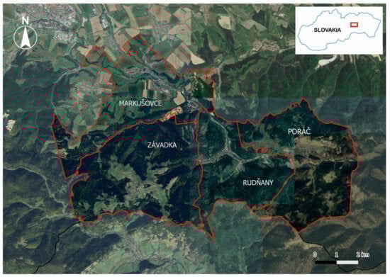
Figure 1.
Location of the study area.
The cadastral territory of Rudňany, with an area of 1363 ha, belongs, according to the geomorphological division of Slovakia, within the geomorphological area of Slovenské rudohorie to the unit Volovské vrchy, subunit Hnilecké vrchy and the northern part to the geomorphological part Galmus. Its altitude ranges from 475 to 959 m a.s.l. The village of Poráč lies at the water adit of the stream Poráčský potok and the stream Zlatník in the Hnilecké vrchy mountains, which are part of Slovenské rudohorie. It is the highest village in the Spišská Nová Ves district with an altitude of 778 m a.s.l. Administratively, the village belongs to the district of Spišská Nová Ves in the Košice Region. Rudňany has 4186 inhabitants (2024) and a population density of 256.1 inhabitants per km2. Poráč has 1009 inhabitants (2024) and a population density of 53.5 inhabitants/km2 [43].
The geological structure of the investigated area (Figure 2) is composed of two pre-Upper Cretaceous (palealpine) nappe units: the Gemericum and the Silicicum. These units are overlain to varying degrees by younger Paleogene and Quaternary sediments [44,45]. The Gemericum is represented by the Dobšiná Group of Late Paleozoic age and by the Rakovec and Gelnica groups of Early Paleozoic age. The dominant lithologies include sandstones, conglomerates, phyllites, products of basaltic volcanism and metamorphosed volcanic rocks, predominantly from the Devonian–Permian periods. The Silicicum is characterized by thick complexes of Middle Triassic limestones and dolomites, which were key factors in the development of the karst landscape of the region. In the northern part of the area, the Central Carpathian Paleogene of the Sub-Tatra Group is present. The most significant lithological types within the Borové Formation of this group comprise breccias, conglomerates, sandstones, sandy limestones, claystones and siltstones. Quaternary sediments in the study area exhibit a specific evolutionary history, closely controlled by the underlying geological structure. These sediments rest upon Paleozoic rocks, but more extensively upon Mesozoic complexes and Paleogene formations. Following the classification of [44,45], the Quaternary deposits are assigned to the undivided Quaternary, the Middle and Upper Pleistocene, and the Holocene. They are composed of a diverse range of fluvial, deluvial, proluvial and anthropogenic sediments.
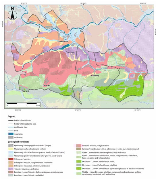
Figure 2.
Geological structure of the study area [44].
Studied Geosites
In the study area, within the cadastral territories of the municipalities of Rudňany, Poráč and Markušovce, 10 geosites were selected as the objects of research and evaluated using the GAM methodology. The investigated geosites are evidence of long-standing mining and processing activities with an assumed differentiated potential use in geotourism. There are no purely natural geosites amongst them; all are relics of anthropogenic activities in former mining landscapes.
GS1 Rochus adit, Rudňany (Figure 3)—its entrance portal is located at an altitude of 468 m a.s.l. The adit was first dug in 1795 and it was completed in 1925. It is the oldest preserved mining object in the region. It is connected to the Mier, Krížová, Pätoracké and Poráč adits. The adit is 4300 m long and has been protected as a national cultural monument since 1973. Its entrance portal has been reconstructed and equipped with information boards. It is the first stop of the Rudňany Mining Nature Trail (completed in 2017). There are plans to make 1500 m of it accessible by a mining train. In front of the adit is the new mining open-air museum, opened on 4 October 2024.
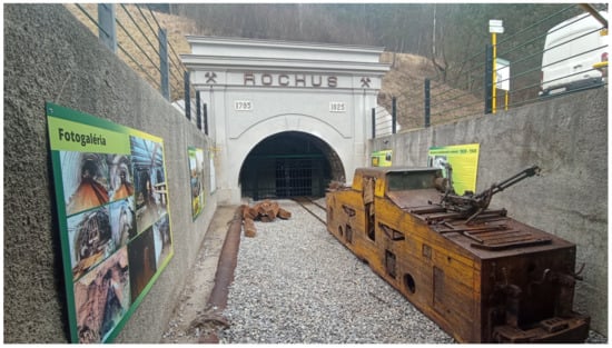
Figure 3.
Entrance portal to the adit Rochus. It is the oldest preserved mining object in the region. It is still in use today as the main ventilation and drainage tunnel, although mining is no longer taking place.
GS2 Mining Archive Rudňany—the archive building is located near the center of the village at an altitude of 495 m a.s.l. It is the sixth stop on the 3000 m long Rudňany Mining Nature Trail and was opened on 9 September 2004 with the help of the municipality and the Rudňany Miners’ Association. The exposition of the archive is divided into three parts (1. professional mining geological and measurement literature, 2. protective equipment, mining reinforcement, drilling equipment, 3. samples of ores and minerals).
GS3 headframe of Mier adit, Rudňany (Figure 4)—it is registered as a national cultural monument as of 9 February 2005. It is located in the area of the Mier mining pit. It was the central adit for vertical transport from the deep horizons to the Rochus adit, which was directly connected to the ore finishing plant. It was also used to transport miners from the surface to the underground. The altitude of the geosite is 511 m a.s.l. and it is the seventh stop on the Rudňany Mining Nature Trail. The tower is illuminated at night and thus forms a distinctive scenic and luminous landmark of the village.
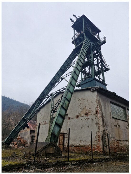
Figure 4.
Headframe of adit Mier has a plan of a double rectangle; the height of the tower is 26 m. The adit was deepened several times to other horizons until it reached its current depth of 484 m in 1981.
GS4 adit Krížová, Rudňany—the portal of the adit was restored and reconstructed in 2006. It was dug in 1835 and was used for the opening of the thick vein. In 1854, it was 80 m deep and in 1925, it was connected to the Rochus corridor. In 1909, petrol locomotives were first used in this adit to transport ore from the adit to the cableway in the adit yard, and from there to the ore sorting plant. The altitude of the portal is 549 m a.s.l. The adit is the last—the ninth—stop on the Rudňany Mining Nature Trail.
GS5 tailings impoundment Markušovce—the central part of the geosite is situated at an altitude of 474 m a.s.l. The shape of the tailings impoundment copies the relief of the lower part of the valley of Markušovský potok, the surface morphology modeled by the sedimentation of flotation sludge. Of the potentially toxic elements, Cu, As, Hg, Mn, Sb are present in the sediments of the tailings impoundment in higher concentrations. The tailings impoundment has a total length of approximately 1085 m and a width of 160–340 m. The area of the tailings impoundment in 1980 was about 10 ha; currently, it is 35 ha. The thickness of the deposited materials varies, the largest being at the lower dam, where it reaches 38 m. The current volume of sludge deposited is approximately 9.9 million tons. The tailings impoundment was in operation between 1963 and 2004.
GS6 Tunnel Orenburg, Markušovce (Figure 5)—it is a 550 m long tunnel at an altitude of 470 m a.s.l. It was dug by miners in the limestone massif of the Hôrka hill to divert the water of the Markušovský potok stream into the neighboring valley of Korytné. The reason for the tunneling and the diversion of Markušovský potok was the expansion of the Markušovce tailings impoundment. The tunnel was completed in 1975. It is passable, and it is a tourist attraction. At the bottom of the tunnel, there is an artificial concrete basin that joins the stream in the Korytné valley. Trout live in the water flowing through the tunnel, and the body of the tunnel itself is a habitat for various species of spiders, gastropods, reptiles and bats.
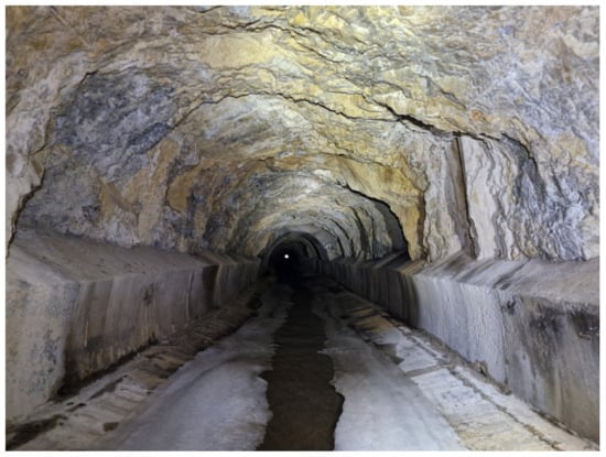
Figure 5.
Tunnel Orenburg is 550 m long, completed in 1975 with the purpose of the diversion of Markušovský potok from the valley Markušovské údolie. The main reason was the expansion of tailings impoundment Markušovce.
GS7 water reservoir Poráčska dolina, Poráč—it was built in 2019 on the site of the former outdoor swimming pool, which was part of the Poráč Park recreational facility. It is located at an altitude of 600 m a.s.l. In close proximity is the mining museum in the Poráčska dolina valley and the ski slope of the Poráč-Park ski area. The main purpose of building the reservoir was to ensure a sufficient water supply for the needs of the near ski resort. As it lies adjacent to the mining museum, it tends to be part of the tour and explanation of water use in mining, even when its construction is not related to that activity. On this basis, we have included it among the geosites studied.
GS8 adit Peter, Poráč—the entrance portal of the adit is at an altitude of 627 m a.s.l. The corridor heads south under the Suchý vrch hill. At present, about 120 m of the straight corridor is accessible. In the first meters, the corridor is supported with wooden reinforcement and later with trapezoidal iron reinforcement, while the rest of the corridor is without reinforcement, only in stone. At the end, the corridor is blocked by not very solid hanging rock. It is the second stop on the Poráč Mining Nature Trail—circuit 1 (following the adit Pavol in the mining museum in the Poráčska dolina valley).
GS9 adit Pavol, Poráč—the portal of the adit is a part of the mining museum in Poráčska dolina, which was opened in September 2018 due to the activity of Tovarišstvo Poráčskeho baníctva (Poráč Mining Association). The museum houses exhibits from the mining industry, such as mining tools, equipment and documents, a guided tour of the interior and exterior of the museum taking 30–45 min. The altitude of the mouth of the tunnel itself is 603 m a.s.l. It is part of the museum tour and also the first stop of the Poráč Mining Nature Trail—circuit 1; the reconstructed route in the adit is 130 m long. It was deepened at the end of the 18th century.
GS10 sinkhole Baniská, Poráč-Rudňany—it is located at an altitude of 825 m a.s.l. It is approximately one kilometer long and its width varies from 15 to 65 m. It was formed near the road leading to Poráč, which had to be moved three times due to the spreading of the cave-in zone. As a result of the subsidence process, the massive sinkhole can be seen in the area as a system of interconnected sinkholes forming a significant longitudinal depression. A total of 158 cracks have been documented in this subsidence zone. The whole area is characterized by more or less intense development of a cracking zone with varying degrees of activity, which indicates that the area is still active in terms of stability. Part of the cracking zone has been used to deposit waste of various kinds, including toxic waste.
3. Materials and Methods
The post-mining landscape is a specific type of landscape significantly affected and disturbed by mining activities. All components of the landscape are affected and, at the same time, the influence of several factors is visible. In order to achieve maximum evaluation effect, we used a combination of two methodological approaches.
In assessing the environmental risks of the area, we used the multi-hazard method [46], which can maximally encompass the individual risks and associated external factors, and also track the direction and intensity of the interactions. We slightly modified the methodology to fit the specificities of the study area. Its application for mining regions brings several benefits. Evaluating each single hazard separately can increase the cost of mitigation. In exceptional cases, a cascading effect may occur, creating a catastrophic scenario with serious social and economic consequences. A full multi-hazard assessment should consider all possible hazard sources and identify all possible interaction scenarios, including chain or domino effects. Unlike other methodologies, in this analysis, it is important to identify which hazard is the trigger. The occurrence of the first hazard triggers, amplifies or modifies the second and may create a chain reaction of several hazards. Dependent hazards can lead to a domino effect.
In this methodology [46], we used two tools: the matrix of interaction and the interaction diagram, which complement each other. The process of preparing for a multi-hazard assessment is divided into three main steps. In the first step, three major groups of hazards are described: mining, natural and technological. The second step deals with the potential interaction based on the common factors of hazards and the conditions of occurrence of hazards. Interactions between hazards are based on their nature—triggering or aggravating. We can visualize potential interactions using both tools: an interaction matrix and an interaction diagram. The third step is aimed at identifying the level of interactions between hazards. The level of interaction is based on the intensity of each hazard and their level of interaction.
The post-mining landscape is a highly disturbed type of landscape, but it is also a type that can be used in a specific kind of tourism, namely geotourism in the form of specific geosites created by mining activities. Evaluation methods based on different criteria are used to assess them. Reynard et al. [47] state that the evaluation methods used mainly include the values of rarity, representativeness and integrity of the feature. Other values, such as scientific, ecological, educational and cultural, vary between methods depending on the objectives of the research.
In this context, Erhartič [48] presented in his work several methods of geosite assessment, each using a specific combination of criteria and indicators. The first so-called Swiss method based on the work of [47] used the following evaluation criteria—scientific value (rarity, representativeness, integrity, palaeogeographic value) and additional value (ecological value—ecological impact, protected sites; aesthetic value—view points, contrast, vertical development; cultural value—religious importance, historical importance, artistic and literary importance, geohistorical importance; economic value—qualitative, quantitative). The Portuguese method in the work of [49] presents the geomorphological value (scientific value; additional value) and management value (use value; protection value). Another method used, referred to as the Spanish method, based on the work of [50], used the scientific or intrinsic value (genesis, morphology, dynamics, chronology, lithology, geologic structures), the cultural or added value (aesthetic value, cultural value, educational value, scientific value, tourist value) and the use and management value (accessibility, vulnerability, sensitivity, intensity of use, risk of degradation, state of conservation, impacts, quality of view, limits of acceptable change). The fourth approach, titled Method for Assessing Tourist Potential, developed in the work by [51], relied on the following criteria: the tourist value (scenic/aesthetic value, scientific value, cultural/historical value, social/economic value) and the exploitation value (degree of exploitation, modality of exploitation). According to [48], all of the above methods and approaches have one common goal, namely, to reduce the subjective factor in the evaluation by means of numerical evaluation and thus to increase the level of objectivity in the comparison of individual geosites.
The Geosite Assessment Model—GAM—was used to assess the geosites in the area. The above model based on the above approaches was elaborated in [52] and slightly modified by [53]. The GAM model used uses 5 groups of indicators divided into two main parts; namely, main values—scientific/educational value (VSE), scenic/aesthetic value (VSA), protection value (VPr) and additional values—functional value (VFn), touristic Value (VTr).
Thus, the main values group (VSA, VSE, VPr) included 15 indicators and the additional values group (VFn, VTr) also included 15 indicators (Table 1). Thus, each of the 10 monitored geosites was assessed using 30 indicators, each of which was assigned a score value ranging from 0 to 1 on a numerical scale of 0–0.25–0.5–0.75–1.0. The resulting total value of the observed geosite was calculated based on the following formula:
GAM = Main Values (VSE + VSA + VPr) + Additional Values (VFn + VTr)

Table 1.
Structure of indicators of the GAM model.
Based on the results of the applied GAM model, it is possible to make a matrix of main and additional values similar to the ones analyzed by [52,53]. The X-axis shows the main values, the Y-axis the additional ones. The final matrix is then divided into 9 zones marked Z1 to Z9, with the main grid lines that form the zones for both the X and Y axis having a value of 5 units. If the assessed geosite was located, for example, in zone Z1, the main values and additional values would be low; if in zone Z5, both the main and additional values would be at a medium level. A high level of the main and additional values would move the geosite up to zone Z9.
4. Results
4.1. Analysis of the Study Region Using the Multi-Hazard Interaction Matrix Tool
For the assessment of the study area, we used the multi-hazard interaction matrix tool, which allows us to visualize the interactions between individual hazards and also to consider the level of interaction. As this is a mining landscape, we identified mining hazards as triggers. At the same time, we also considered external factors, namely the human factor and the technical infrastructure, specifically transport (Figure 6).
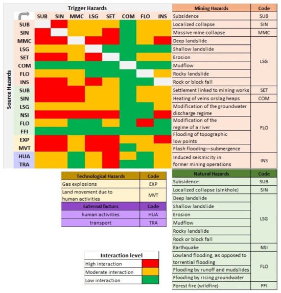
Figure 6.
Multi-hazard interaction matrix of study area.
In the studied locality Rudňany-Poráč, intensive mining activity went on for several decades, its impact visible both on the surface and underground. On the surface, all human and economic activities conformed to mining activities. Even in the past, surface mining shaped the spatial distribution of human activities (housing, transport, etc.). With the gradual expansion of mining below the surface, large mining complexes were created—Starý banský areál (old mining compound), Nový priemyselný závod (new industrial plant), compound of Mier adit, compound of Západ adit, compound of RP II adit, compound of Poráč adit, etc.
A major problem in the territory is the contamination of all environmental components with heavy metals, mainly mercury, arsenic, manganese and cadmium. More than 30 years have passed since mining ceased, but the negative effects of mining are still visible. In the Rudňany ore field, there are many sources of hazardous constituents that can be released into the environment by weathering processes and spread by water transport or wind. These are natural geochemical anomalies (ore deposits), piles of mined rubble (ore, spoil), waste dumps after ore treatment by milling and roasting, flotation sludge dumps—tailings compound, area soil anomalies contaminated by emissions from technological gases and dust fallout from thermal treatment of ores. The above sources of contamination are concentrated mainly along the outlets of the veins to the surface, the mouths of the main mine workings to the surface and in the area of Nový priemyselný závod (new industrial plant), where treatment of the mined ore was carried out for a long time [16,54].
The highest level of risk of the cascade effect occurring is a result of two factors: the geological instability of the area in the Pätoracké section, where part of the inhabited area is located in the caving-in area and the spread of heavy metals through the hydrological network. The hydrothermal–metamorphic vein of siderite–sulphide–barite deposit at Rudňany–Poráč has been flooded since 2006 up to the hereditary Rochus horizon, by which it is also naturally drained by gravity. The recipient of the mine water flowing by gravity through the Rochus adit to the surface is the Rudnianský potok stream [55]. The results of periodic measurements indicate irregular exceeding of heavy metal limits in Rudnianský potok. The problem becomes more serious during heavier rains when the tailings impoundment is “water-washed” and heavy metals are washed into the river network. There is also a risk to the health of the residents as some of the local community use the water from the stream as drinking water.
Another significant problem is the Baniská sinkhole and its geological instability. A mining technique called cave-in mining without backfill was used here and it is this which has caused a large sinkhole to form. Its gradual expansion has also affected the only access road to the village of Poráč. The former adit compound RP II is located nearby, where the built-up part of the village (Roma settlement Pätoracké) is located. Its existence in the cave-in zone is a mistake from the managing authorities. The paradox is that in this part, low-cost houses have been built for people from socially disadvantaged backgrounds and this community is growing, which leads to an increased risk of a cascading effect. Natural seismicity as well as human activities on the surface and underground may trigger further sinkholes that may destroy human dwellings on the western side of the cave-in zone or even the only access road on the eastern side.
4.2. Analysis of Selected Mining Landforms Using the Interaction Diagram Tool
4.2.1. Sinkhole Baniská
Baniská sinkhole is a highly negative element in the landscape and extends from the Poráč adit westwards to the Sv. Duch adit. Linear in character, it is located at an altitude of 825 m a.s.l., is approximately one kilometer long and its width varies from 15 to 65 m. A total of 158 cracks have been documented in this cave zone and regular geological monitoring is carried out in the area. The consequences of the method of reclamation, which appear to be questionable, are a problem. The entire area that collapsed has been filled in with fly ash from a power station. During transport, however, fly ash was blown from the trucks and covered houses, vegetation and property of the local inhabitants. It also had a negative impact on the air quality in the village. Even though the ash is partially covered with soil, it still ends up in the air in strong winds and makes life unpleasant for local residents.
The results of geological reports [6,55,56] show that the zone is still active. In the past, this zone was geologically very unstable and the risk of subsidence and caving-in was very high. Today, only the eastern part is geologically unstable, but due to its extent, there is still a high risk of further subsidence. There is also a risk of landslides. The impacts of mining activities have recently manifested themselves in some parts of the cave-in zone, causing sinkhole extension, most often in the form of secondary retrograde slope deformation into the wider vicinity of the sinkholes by gravitational loosening and disintegration of rock blocks, block rockfalls, rock slides, etc. [55].
The western part of the sinkhole can be morphologically seen in a stretch about 100 m in length. In terms of activity of sinkhole boundary extension, no observable changes were detected in the 2021 field reconnaissance compared to the previous period. Considering that no expansion or formation of new sinkholes has been observed here in the last few years, this part of the cave-in zone can be characterized as temporarily stabilized in terms of long-term development [55].
It is important to consider the high degree of interaction between mining hazards and external factors (Figure 7). The human factor is the most intense and this interaction is two-sided. In the past, there were premises of adit 5 RP II and human dwellings in the vicinity of the undermined zone of the mine. After the area became active and unstable and subsidence and caving-in occurred, the local inhabitants were relocated to other parts of the village. The biggest problem, however, was that these abandoned areas started to be occupied by the Romani community, which continues to increase in space and population. Despite the fact that it is a geologically unstable area and environmentally burdened, the Romani community still lives there and construction of low-cost housing blocks continues. The inhabitants of the local community enter underground spaces, dismantle iron reinforcements and thus contribute to the instability of the underground spaces, while at the same time endangering their own dwellings which are built in this zone.
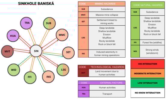
Figure 7.
Interaction diagram of sinkhole Baniská.
A moderate level of impact of the sinkhole can be seen on the local road. The village of Poráč is a terminal village and that is the only access road, which runs in close proximity to the sinkhole under study. The gradual expansion of the cave-in area has led to the road being shifted several times for safety reasons. Currently, the road runs along sloping terrain where maintenance is difficult during the winter months. Should the cave-in area expand further, the configuration of the terrain no longer provides room for further shifting.
4.2.2. Mining Tailings Impoundment “Markušovce”
This tailings impoundment has been used to store sludge from ore processing since the 1960s. It extends from the outlet of the valley of the Markušovský potok stream to the valley of the Rudnianský potok stream. The tailings impoundment has a total length of approximately 1085 m and a width of between 160 and 340 m. The area of the tailings impoundment in 1980 was approximately 10 ha; currently, it is 35 ha. The thickness of the deposited materials varies, with the largest being at the lower dam at 38 m. The size of the impoundment was once insufficient, so the local stream was diverted by the tunnel called “Slovenský Orenburg” under the mountain so that the sludge flooded the whole valley. Groundwater pumped from the Mier adit also flows here. The water seeping from the tailings impoundment is subsequently diverted into Rudnianský potok. The tailings impoundment has a complex internal structure, due to the different distribution of constituents and grain size fractions present. The composition of the tailings impoundment is influenced by the development of treatment technologies and their efficiency and changes in the composition of the mined ores.
The tailings impoundment of Markušovce represents a significant environmental burden with its high concentration of heavy metals, especially mercury, arsenic and lead, which are highly toxic and dangerous to all components of the environment and to all living organisms, including humans. As can be seen in Figure 8, there are significant interactions between the tailings impoundment and the surrounding environment. The sludge was transported to the tailings impoundment using a sludge pipeline and was in the form of a liquid mixture. After the water evaporated, it was deposited as a very fine and highly toxic sludge. In drier months, it would end up in the air and subsequently cover vegetation and crops. Heavy metals are deposited in the human body and show slow changes that can cause cancer as well as certain mental disorders.
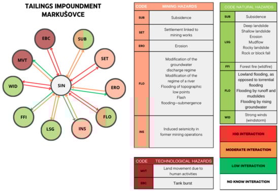
Figure 8.
Interaction diagram of tailings impoundment Markušovce.
Based on the results of the hydrogeological surveys, it can be concluded that there is a high risk of impact on the groundwater flow and quality. The impact of the excavated mine workings on the hydrogeological conditions of the site consists in the modification of the original circulation and groundwater regime of the hydrogeological massif of the Palaeozoic metamorphic rocks of the Gemericum. The results of the analyses have shown that the limits of heavy metals (Hg, Sb) in soil sediments and groundwater have been exceeded and pose a high cumulative risk to both adult and child inhabitants of the village [55].
Another problem is the spread of heavy metals through the hydrological network. In the early days of mining, mine workings were dewatered by gravity discharge through the opening adits. As mining progressed in depth, mining pits were excavated, requiring a more sophisticated method of dewatering by pumping. Pumping stations at individual pits pushed mine water from the lowest horizons to the level of the Rochus horizon (461 m a.s.l., the level of the local erosion base), through which it flowed by gravity to the surface and was discharged onto the tailings impoundment. At present, virtually all the water of the deposit concentrates in the Mier pit, where it is pumped to the level of the Rochus horizon. Measurement and evaluation of variations in the intensity of mine water inflows in relation to precipitation and surface flows in the central part of the RRP (veins Droždiak and Hrubá) were the center of attention of several authors [55,57,58,59,60]. Based on the results of their measurements, they found a rapid response of mine water inflows to precipitation (most often from a few days to one week) in places where the caves extend to the surface and no response in inflows from deeper unmined parts of the deposit. A problem arises during periods of heavier rainfall, when torrential rains wash heavy metals from the tailings into Rudnianský potok and not only the bottom sediments but also the surface water are polluted. Long-term research [57,58,60] and recent measurements [55] show that the water quality in the streams is risky due to the high content of Mn, As, Mg, SO4 and TDS. The quality of water in Rudnianský potok, which receives water from the mine, is particularly threatened by manganese; the surface water quality limit is usually exceeded 180 days per year. The investigated mine water is not suitable for drinking purposes due to the persistently high TDS, Mn, Mg and SO4 contents, as well as arsenic and antimony contents, which are occasionally present and exceed the limit values. The Romani settlement of Zabíjanec is located close to the outlet of the hereditary Rochus adit, which discharges mine water. The local inhabitants have difficult access to drinking water and therefore often use water from the stream as drinking water. A higher morbidity rate of local inhabitants, especially children, is often observed here than in the rest of the village [55].
4.3. Analysis of Geosites Using the Geosite Assessment Model (GAM)
Based on the results of the assessment of the potential of individual geolocations for geotourism (Table 2, Figure 9, Figure 10 and Figure 11) using the GAM methodology, the following facts can be stated. Three geosites have high potential (15.1 p. and more) in the assessed area, namely GS9 Pavol adit, Poráč with 16.25 points (p.), GS7 Poráčska dolina reservoir with the value of 16.00 p. southeast of the village of Poráč and GS1 Rochus adit (15.25 p.) to the north of Rudňany. Two geosites directly in the residential area of Rudňany—GS2 Mining Archive Rudňany (13.25) and the nearby GS3 headframe of Mier adit (12.50), as well as GS8 Pavol adit, Poráč (14.00) in Poráčska dolina and GS5 tailings impoundment of Markušovce in the western part of the area—all have medium potential (10.1–15.0 p.) for geotourism. Low potential (0–10.0 p.) was recorded by GS10 Baniská sinkhole (7.75) to the south of Poráč, GS6 Tunnel Orenburg (8.75) near the tailings impoundment of Markušovce and GS4 Krížová adit (9.75) in Rudňany.
Table 2.
Point values of individual geosites and their affiliation to the field in matrix.
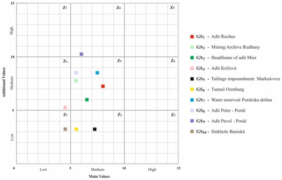
Figure 9.
Matrix of individual geosites and their values.
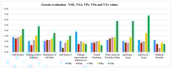
Figure 10.
Point values of geosites for individual value groups.
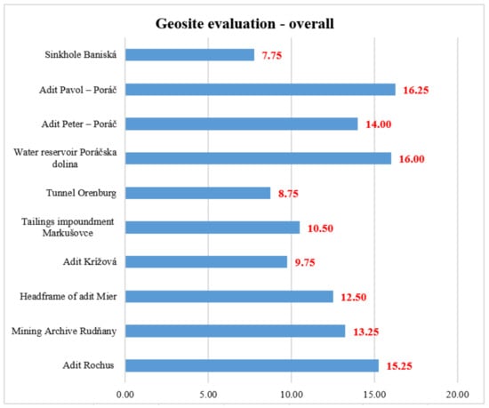
Figure 11.
Total point value of individual geosites.
The highest total point value (16.25) is achieved by GS9 Pavol adit in Poráč. Within the matrix, it is located in field Z8, which represents a high level of additional and medium level of main values. The geosite scored particularly highly within the VTr. It is part of the compound of the Mining Museum in the Poráčska dolina valley, easily accessible to tourists, and includes a guided tour. The necessary tourist infrastructure (accommodation, catering facilities, parking, wellness, resting places, etc.) is located in close proximity. The entrance to the adit has been renovated and the route is easy and safe. There are also educational boards near the adit, forming part of the Mining Nature Trail. Organized visits arranged by telephone are popular and, during the summer months, a guide is available in the building of the Mining Museum compound. The disadvantages of the geosite (reflected in the lower scores for the main values) are the remoteness of the main transport routes, the small area of the geosite for a large number of visitors and the existence of several similar geosites in the region.
The greatest number of assessed geosites are within the Z5 field, representing a medium level of both additional and main values. Of these geosites, the highest overall score value (16.00) is achieved by geosite GS7 Poráčska dolina reservoir in Poráč. Similar to geosite GS9, it has a high score, especially within the tourist values (VTr). It is usable all year round as a resting and recreational site. The necessary tourist infrastructure (accommodation, catering facilities, parking, wellness, resting places, ski resort, etc.) is located in close proximity. It is a habitat for several animal species which can be safely observed. The main disadvantages of these geosites are the remoteness of the main transport routes and poor promotion. In the Z5 field, the GS1 Rochus adit in the Rudňany geosite has the second highest overall point value (15.25) and the third highest within all the fields. The curve for all five sets of values is more even for this geosite, indicating predominantly intermediate point values (interval 0.5). The exception is the tourist value group (VTr), which scores slightly more highly. The geosite is easily accessible by car and bus, can receive more visitors due to the size of its underground spaces, and its substantial length is artificially brightened. It is protected as a national cultural monument, its entrance portal has been restored and there are information boards in close proximity to the portal of the adit and the Mining Open-Air Museum. The geosite is part of the Mining Nature Trail and is quite well promoted. Its disadvantage is its proximity to heavily burdened environmental areas and emission centers and localities with a maladjusted population. It should also be pointed out that although the geosite is being prepared for public access, it is still only open to people with a special permit.
In the matrix, there are three more geosites (GS8, GS2 and GS3) in field Z5. The fourth highest overall point value (14.00) of all geosites is achieved by GS8 Peter adit in Poráč, with especially high values in VTr. The necessary tourist infrastructure (accommodation, catering facilities, wellness, resting places, etc.) is located in relative proximity. The entrance to the adit is reconstructed and it takes about 5–10 min on foot to reach the portal of the adit. The adit passage itself is 120 m long, and the route is easy and safe. There is also an educational board near the adit and the geosite is also part of the Mining Nature Trail. The disadvantages of the geosite (reflected in the lower scores for the main values) are the remoteness of the main transport routes, the small size of the geosite for a large number of visitors and the existence of several similar geosites in the region. The portal of the adit, unlike GS9, is not located in the Mining Museum compound in Poráčska dolina; hence, it is less visited. The fifth highest overall point value (13.25) of all geosites is achieved by GS2 Mining Archive Rudňany. The geosite achieves lower point values in both VSA and conservation value (VPr) whereas it scores highly in VTr. The geosite is suitable for organized visits and for lectures and educational events. As it is indoors, it is also usable in bad weather and throughout the year. In one place, there are important artefacts and exhibitions explaining the history of mining activity in the region. The sixth highest overall point value (12.50) of all geosites is achieved by the GS3 headframe of Mier adit. For the first four values, it achieves a relatively even score, with a higher tourist value. The geosite itself is easily accessible by car and bus and is visible from afar even at night, as it is illuminated. It forms a distinctive landscape landmark in the village. It is also suitable for organized visits by many tourists, and the Mining Archive is relatively close by. The geosite is protected as a national cultural monument and is one of the stops on the Mining Nature Trail. The disadvantage of the geosite is its proximity to heavily burdened environmental areas and emission centers. Currently, climbing the ladder to the top of the headframe itself is not possible. Making it accessible would significantly increase the scenic (aesthetic) value of the geosite.
There are two geolocations (GS5 and GS6) in the Z2 field with low levels of additional and medium levels of main values. The GS5 tailings impoundment of Markušovce has the seventh highest overall score (10.50) of all geosites. It is the largest geosite in area with multiple viewpoints; the area is suitable for organized visits and large numbers of visitors. It scores the highest in scientific (educational) value (VSE) as it provides a good demonstration of various geomorphological, chemical and successional processes. Its disadvantages are more difficult transport accessibility, remoteness, proximity to emission centers, extreme environmental load and toxicity of the environment. The ninth highest overall score (8.75) of all geosites is achieved by the GS6 Orenburg Tunnel. It is located in close proximity to the previous geosite and has a balanced curve in its first four values, the lowest being its tourist value. Its disadvantages are more difficult transport accessibility and its greatest remoteness from all other geosites, as well as its proximity to emission centers as well as to the extremely environmentally burdened geosite GS5, which, however, is not reflected in the environmental quality of geosite GS6. Due to its nature and remoteness, the geosite is not suitable for large, organized groups of visitors and requires torchlight to pass through. However, it is suitable for more adventurous people and offers a wide range of animal species.
In the Z4 field, with a medium level of additional and low level of main values, is the geosite GS4 Krížová adit, which scores the third lowest total point value (9.75) of all geosites. It has a low score for scenic/aesthetic value, is not visible from the main access road and there are other similar sites and an emission center in its vicinity. It scores highest on tourist value; its entrance portal has been restored and there is an educational board adjacent to the adit portal. The geosite is part of the Mining Nature Trail and is suitable for small organized tourist groups.
In the Z1 field, with low level of additional and main values, is GS10 Baniská sinkhole. Of all the geosites, it has the lowest total point value (7.75). It has the highest score for scientific/educational value, as it is a suitable example of geomorphological processes in an undermined area. The geosite is thus usable both in scientific research and in the educational process. It has a distinctly linear character but its disadvantages are difficulty of access and lack of promotional or other professional or educational materials. The geosite is still significantly active in terms of geomorphological processes, which means a lower level of visitor safety. It is not visible from the main access road between Rudňany and Poráč and, in addition, is used as a dump for various types of waste, including toxic waste.
The map (Figure 12) spatially shows the results of both analyses used. Using the GAM method, the selected geosites were evaluated and, at the same time, using the scoring methodology, we can see their suitability and potential for the development of geotourism. Given the specificity of the post-mining landscape, it is also necessary to assess the full range of risks that may limit or even completely prevent the development of geotourism. Therefore, using the multi-hazard assessment method, we monitored the direction and level of interaction of each hazard and based on this, we designated the risk zones. This is important for proper planning and management of individual geohazards. It also reduces the risk of hazardous situations during the implementation of individual geotourism activities. The results of the analyses show that there are two geosites in the zone of greatest danger—the GS5 tailings impoundment of Markušovce and GS10 Baniská sinkhole. At the same time, these localities reached medium and lower GAM scores. Given that these study sites represent significant environmental burdens, we also assessed them separately using the interaction diagram method. There is one site in the zone of medium threat—GS6 Orenburg Tunnel, which also has a low point value of potential. The main factor is its relatively poor accessibility and lower public awareness of its existence. In the low threat zone are the following sites—GS1 Rochus adit, GS2 Rudňany Mining Archive, GS3 headframe of Mier adit, GS4 Krížová adit, GS7 Poráčska dolina reservoir, GS8 Peter adit in Poráč and GS9 Pavol adit in Poráč. These sites have a medium to high GAM potential score, good transport accessibility, nice landscape and information boards. The last three geolocations—GS7, GS8 and GS9—are located in Poráčska dolina, where there are also two ski resorts and accommodation and catering facilities available.
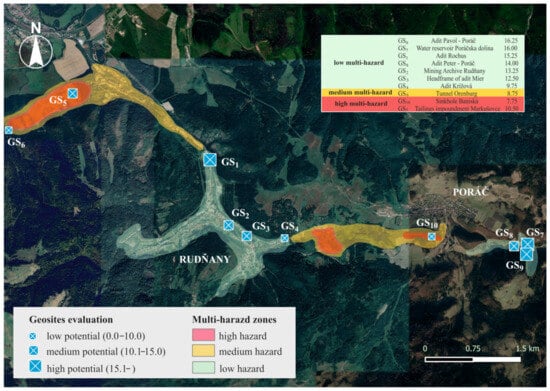
Figure 12.
Multi-hazard zones and geosites.
5. Discussion
The post-mining landscape represents a specific type of landscape, all of whose components are heavily impaired and many of which are irreversibly transformed. Visible manifestations on the surface are mining landforms, which may show varying degrees of reclamation, many of which have been left without human intervention. Another manifestation which is not as visually obvious but is all the more dangerous, is the contamination of individual components by heavy metals. The process of environmental recovery takes several decades with air quality parameters improving the fastest. The quality of groundwater and surface water also gradually improves but the soil, which is often used for growing agricultural crops even if the established limits of heavy metals and harmful substances are exceeded, is the longest contaminated. In spite of these negative features, this post-mining landscape still holds great and often untapped potential for the development of geotourism. It is important to preserve the historical heritage of these regions and to exploit their potential for tourism, science and education. Given the specific nature of the landscape, however, it is first and foremost important to analyze its risks, particularly environmental risks, and to ensure the safety of individual geosites. For this reason, we have opted for a combined approach in the analysis. We used the multi-hazard risk assessment methodology [46], which is recommended for mining regions. The most intense level of interaction is between mining hazards that act as triggers; natural hazards have a predominantly medium level of interaction while the lowest level of interaction is between mining and technological hazards. There have, as of yet, been no recovery activities taking place after mining ended nor is there any other industrial activity in the surrounding area. There is also a risk of cascading effect, but it is not permanent. Heavy rainfall, natural or induced seismicity may be risky but the greatest risk for a domino effect is human activities. During the preparation of individual geosites, especially during underground work, the statics of the adits may be disturbed, which could trigger a cascade reaction.
For the assessed geosites in the analyzed post-mining landscape, according to the GAM model, tourist value (VTr) was a critical determinant influencing their overall high ranking. This had a significant influence with the two highest ranked geosites: the Pavol adit in Poráč and the Poráčska dolina reservoir with 6.75 p. (41.5% share of the total score) and 5.75 p. (35.9%), respectively. Both geosites are part of the Mining Museum in Poráčska dolina, which benefits from the presence of tourist infrastructure, specifically accommodation and catering facilities, car parks, wellness facilities, resting places, etc. The high VTr value (5.75 p., 41.1% share) is also reflected in the high rating of the third geosite in Poráčska dolina, namely the Peter adit (Figure 13). The VTr value also had a significant impact on the overall rating of the Rudňany Mining Archive and the Rochus adit, which has the potential to become a major geotourism attraction in the area once the ongoing refurbishment is completed and it is open to the public. On the contrary, the determinant of a low evaluation of geosites was their scenic/aesthetic value, which significantly contributed to the overall poor evaluation of the Krížová adit, Baniská sinkhole and the tailings impoundment of Markušovce. The low VTr value of the two geosites contributed significantly to their low rating, which was also reflected in the poor rating of the Orenburg tunnel due to its remoteness and poor transport accessibility. Scientific/educational value as a determinant of a higher rating was particularly evident in the tailings impoundment Markušovce geosite (Figure 14) with 3.75 p. (demonstration of various geomorphological, chemical and successional processes) and the Baniská sinkhole with 2.25 p. (demonstration of geomorphological processes in the undermined area).
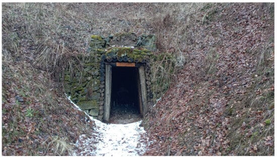
Figure 13.
The adit Peter is a 120 m long straight corridor, which is accessible. It was first mentioned in writing in 1839. This geosite has the high touristic value (5.75 p.).
Figure 14.
Tailings impoundment Markušovce was in operation between 1963 and 2004. The current volume of sludge deposited is approximately 9.9 million tons. It has the high Scientific/educational value (3.75 p.).
In the final matrix of main and additional values of geotouristic potential, the largest representation of geosites is observed within the middle level of values, namely the Z5 field, where five geosites can be found. This is in line with several other works using the GAM methodology, or a related methodology using a matrix of values [61,62,63], where one of the fields is also dominant. In the case of GS7 and GS8, their position in the Z5 field is a reflection of their medium level main values (VSE, VSA, VPr). As for the additional values, we can speak of a middle level in the group of VFn values, while the group of VTr values is high. In the case of GS1, GS2 and GS3, the curve of all five groups of values is more balanced; the predominance of VTr values is not as significant as in the case of GS7 and GS8. The exception with a medium level of values is the VSA group of values in GS2, the low level of which is because the geosite itself is located in the building.
By comparing the areas of the allocated risk levels with the location of the individual geosites (Figure 12), several relations can be identified. The high multi-hazard areas contain geosites with low to medium potential for geotourism. One example is GS10 (with the lowest overall potential score), where the concerned risks apply to all five groups of potential values for geotourism. In the case of GS5, due to the scientific/educational value, the geosite has been attributed medium potential for geotourism even though it belongs to an area with a high degree of multi-hazard. This premise was also confirmed in reverse, concerning the occurrence of geosites with a high potential for geotourism in areas with a low degree of multi-hazard. This group includes the GS1, GS7 and GS9 geosites, where the low degree of multi-hazard is reflected in a more intensive use of the area, which was particularly evident in the tourist value scores of the geosites in question.
The post-mining landscape provides many possibilities for use in geotourism or geoeducation within the framework of the presentation of cultural heritage [64,65]. A significant part is also the geosystem services provided by our geological heritage [66]. The results of the risk assessment as well as the assessment of individual geolosites confirm the suitability of using both methodologies in this type of research. The multi-hazard assessment methodology used can also be found in the works of other authors [1,46,67]. Their results support our findings on the suitability of applying this methodology for the post-mining landscape. Since its first use [52], the GAM model has become one of the frequently used methodologies for evaluating geosites in terms of their potential for geotourism [53,68]. The increasing number of works with this methodology is in itself proof of its suitability for a given type of research. One of the forms of upgrading this methodology is its modification into the form of the so-called Modified M-GAM model [69,70,71]. The use of the multi-hazard assessment methodology in our work has a more applied dimension and its added value is its combination with the GAM methodology—other authors also point out the suitability of combining methodologies in this area [72].
6. Conclusions
The main contribution of the work is the combination and use of two relatively separate assessment methods for the purpose of risk analysis and the subsequent potential of the studied area for geotourism in relation to these risks. This study highlights the potential for tourism development in former mining landscapes that are significantly anthropogenically transformed and environmentally stressed. In this type of landscape, it is possible to identify potential points or area geosites, reflecting many years of human activity and carrying cultural and historical significance, mining/industrial traditions of the territory and allowing to identify the “genius loci” of the territory. Tourists with an interest in history and artefacts of anthropogenic activity can help to develop the former mining landscape in terms of its alternative use from the perspective of geotourism (in this case, a specific form—mining tourism). The mapping and analysis of the primary geotourism offer, in terms of the occurrence of geosites, is one way to support regional development as well as to optimally manage the area. The next step is the implementation of the acquired knowledge into important development documents and support from the decision-making authorities, including the identification of financial resources.
The area in question is a good example of a territory impacted by mining and subsequent processing activities which can be used for educational and scientific purposes. The individual geosites are unique in their own way, illustrate the history of mining and the whole region; the mining techniques and procedures used and at the same time show the condition of the mining landscape and the negative consequences that occur after the end of active mining. Once adequate engineering and technical modifications of the geological sites have been carried out, it is possible to visit them “in situ”, both on the surface and underground. It is possible to demonstrate and present directly on site the whole range of processes that take place in this specific type of landscape, from geomorphological (erosion, subsidence and landslides), socio-economic (change in demographic and economic structure) to environmental changes (succession of vegetation, gradual return of indigenous biota and non-indigenous species). The specificity and uniqueness of the mining landscape also encourages the discovery of new scientific knowledge, which is the result of the intersection of several scientific fields and is a space for coordinated cooperation in the restoration and conservation of this environmentally disturbed environment.
There are certain limits within the research carried out. One of them is the relative speed of changes in anthropogenic geosites over time, which change more dynamically than in the case of geosites of a natural nature. Another limitation is the more difficult accessibility of some geosites in terms of their exposure (Tunnel Orenburg) or the level of environmental risks (tailings impoundment Markušovce). A certain limit is also the degree of subjectivity in connection with the evaluation of individual criteria for geosites, which is eliminated by using the quantitative GAM model.
For the further development of geotourism in the concerned area, it is necessary, first of all, to ensure the safety and minimization of risks associated with former mining activities, to implement the necessary restoration activities and measures to reduce environmental burdens. At the same time, it is necessary to invest in supporting infrastructure and promotion of geosites, as well as to increase awareness of the local residents about development activities and risks, which are directly related to the geosites in the region. It is also necessary to promote a sustainable model of geotourism with respect to the protection of the environment, cultural heritage and the local community.
Author Contributions
Conceptualization, V.Č. and R.K.; methodology, R.K. and J.K.; software, J.V.; validation, V.Č. and J.K.; formal analysis, V.Č. and R.K.; investigation, V.Č., R.K., J.K. and J.V.; resources, V.Č. and J.K.; data curation, J.V. and R.K.; writing—original draft preparation, J.K., R.K. and V.Č.; writing—review and editing, V.Č. and R.K.; visualization, J.V.; supervision, V.Č. and R.K.; project administration, V.Č.; funding acquisition, V.Č. All authors have read and agreed to the published version of the manuscript.
Funding
This research was funded by VEGA; Ministry of Education, Research, Development and Youth of the Slovak Republic, under grant number 1/0271/25.
Data Availability Statement
The data presented in this study are available on request from the corresponding author.
Conflicts of Interest
The authors declare no conflicts of interest.
References
- Delmonaco, G.; Margottini, C.; Spizzichino, D. Report on a New Methodology for Multi-Risk Assessment and the Harmonisation of Different Natural Risk Maps. Deliverable 3.1; ARMONIA: Rome, Italy, 2006. [Google Scholar]
- Mavrommatis, A.; Damigos, D.; Mirasgedis, S. Towards a comprehensive framework for climate change multi-risk assessment in the mining industry. Infrastructures 2019, 4, 38. [Google Scholar] [CrossRef]
- Sigtryggsdottir, F.G.; Snæbjörnsson, J.T.; Grande, L.; Sigbjörnsson, R. Methodology for geohazard assessment for hydropower projects. Nat. Hazards 2015, 79, 1299–1331. [Google Scholar] [CrossRef]
- Hancuľák, J.; Bobro, M.; Šestinová, O.; Brehuv, J.; Slančo, P. Ortuť v prostredí starých banských záťaží Rudnian a Merníka. Acta Montan. Slovaca 2006, 11, 295–299. [Google Scholar]
- Bajtoš, P.; Záhorová, Ľ.; Rapant, S.; Pramuka, S. Geological monitoring of mining influence on the environment in risk-bearing slovak areas in years 2007–2011. Miner. Slovaca 2012, 44, 375–392. [Google Scholar]
- Liščák, P.; Bajtoš, P.; Mašlár, P.; Mašlárová, I. Vplyv Ťažby Nerastov na Životné Prostredie. Podsystém 04: Vplyv Ťažby Nerastov na Životné Prostredie; GÚDŠ: Spišská Nová Ves, Slovakia, 2015; 77p. [Google Scholar]
- Petrák, M.; Kučerová, G.; Tóth, R.; Lalinská-Voleková, B.; Šottník, P.; Jurkovič, Ľ.; Hiller, E.; Vozár, J. Mineralogické a geochemické hodnotenie materiálu odkaliska Markušovce. Miner. Slovaca 2011, 43, 395–408. [Google Scholar]
- Šottník, P.; Jurkovič, Ľ.; Vozár, J.; Lalinská-Voleková, B. Geochemical and mineralogical evaluation of Slovinky tailing impoundment material (Slovakia). In Proceedings of the 11th International Multidisciplinary Scientific Geo Conference, Albena, Bulgaria, 20–25 June 2011; STEF92 Technology Ltd.: Sofia, Bulgaria, 2011; pp. 375–380. [Google Scholar]
- Tóth, R.; Hiller, E.; Petrák, M.; Jurkovič, Ľ.; Šottník, P.; Vozár, J.; Peťková, K. Tailing impoundments Markušovce and Slovinky: Application of the methodology for evaluation impoundment sediments from ore processing on the model impoundments. Miner. Slovaca 2013, 45, 125–130. [Google Scholar]
- Čech, V.; Krokusová, J.; Kunaková, L. Odkalisko Slovinky pri Krompachoch: (geografické aspekty environmentálnej záťaže). Folia Geogr. 2011, 17, 64–81. [Google Scholar]
- Čech, V.; Michaleli, E.; Krokusová, J.; Ivanová, M. Contamination of selected components of environment in the middle Spiš region (Slovak republic). Int. Sci. Conf. Geobalc. 2015, 1, 43–49. [Google Scholar]
- Michaeli, E.; Krokusová, J.; Solár, V.; Ivanová, M. Flotation tailings pond as the environmental load in the middle Spiš at the village Markušovce and the proposals on the remediation. In Ecology, Economics, Education and Legislation, Proceedings of the 16th International Multidisciplinary Scientific Geoconference SGEM, Albena, Bulgaria, 30 June–6 July 2016; STEF92 Technology: Sofia, Bulgaria, 2016; pp. 311–318. [Google Scholar]
- Krokusová, J.; Pasternák, T. Potenciál bývalých baníckych obcí stredného Spiša (Rudňany a Slovinky) pre vznik ekomúzea. Folia Oecol. 2016, 8, 58–71. [Google Scholar]
- Čech, V.; Krokusová, J. Utilisation of environmentally degraded area by mining activity: A case study of Slovinky tailing impoundment in Slovakia. Acta Montan. Slovaca 2017, 22, 180–192. [Google Scholar]
- Hronček, P.; Čech, P.; Krokusová, J.; Demková, L. Analýza obsahu ťažkých kovov v Slovinskom potoku v Strednospišskej zaťaženej oblasti. Geogr. Cassoviensis 2017, 11, 111–123. [Google Scholar]
- Čech, V.; Hrončeková Gregorová, B.; Krokusová, J.; Košová, V.; Hronček, P.; Molokáč, M.; Hlaváčová, J. Environmentally degraded mining areas of eastern Slovakia as a potential object of geotourism. Sustainability 2020, 12, 6029. [Google Scholar] [CrossRef]
- Čech, V.; Krokusová, J. Challenges and risks of geotourism development on the example of the former mining region of the central Spiš in Slovakia. In Ecology and Environmental Protection, Proceedings of the International Multidisciplinary Scientific Geoconference: Science and Technologies in Geology, Exploration and Mining, Albena, Bulgaria, 1–7 July 2024; Trofymchuk, O., Rivza, B., Eds.; STEF92 Technology Ltd.: Sofia, Bulgaria, 2024; pp. 33–40. [Google Scholar]
- Etigemane, H.; Muniswamy, D. Spatial Distribution of Heavy Metals around the Gold Mine Ore Tailings of Hatti, Karnataka State, India. Landsc. Environ. 2018, 11, 35–44. [Google Scholar]
- Gutierrez, M.; Collette, Z.; Mcclanahan, A.; Mickus, K. Mobility of Metals in Sediments Contaminated with Historical Mining Wastes: Example from the Tri-State Mining District, USA. Soil Syst. 2019, 3, 22. [Google Scholar] [CrossRef]
- Wang, P.; Sun, Z.; Hu, Y.; Cheng, H. Leaching of heavy metals from abandoned mine tailings brought by precipitation and the associated environmental impact. Sci. Total Environ. 2019, 695, 133893. [Google Scholar] [CrossRef]
- Zhang, X.; Yang, L.; Li, Y.; Li, H.; Wang, W.; Ye, B. Impacts of lead/zinc mining and smelting on the environment and human health in China. Environ. Monit. Assess. 2011, 184, 2261–2273. [Google Scholar] [CrossRef]
- Sarker, S.K.; Haque, N.; Bhuiyan, M.; Bruckard, W.; Pramanik, B.K. Recovery of strategically important critical minerals from mine tailings. J. Environ. Chem. Eng. 2022, 10, 107622. [Google Scholar] [CrossRef]
- MPAO. Ministerstvo Průmyslu a Obchodu. Národní Strategie Regenerace Brownfieldů; MPAO: Praha, Czech Republic, 2008; 12p.
- Chen, X.W.; Wong, J.T.F.; Leung, A.O.W.; Ng, C.W.W.; Wong, M.H. Comparison of plant and bacterial communities between a subtropical landfill topsoil 15 years after restoration and a natural area. Waste Manag. 2017, 63, 49–57. [Google Scholar] [CrossRef]
- Pełka-Gościniak, J. Restoring nature in mining areas of the Silesian Upland (Poland). Earth Surf. Process. Landf. 2006, 31, 1685–1691. [Google Scholar] [CrossRef]
- Gregorová, B.; Hronček, P.; Tometzová, D.; Molokáč, M.; Čech, V. Transforming Brownfields as Tourism Destinations and Their Sustainability on the Example of Slovakia. Sustainability 2020, 12, 10569. [Google Scholar] [CrossRef]
- Kantor-Pietraga, I.; Zdyrko, A.; Bednarczyk, J. Semi-natural areas on post-mining brownfields as an opportunity to strengthen the attractiveness of a small town. An example of radzionków in southern Poland. Land 2021, 10, 761. [Google Scholar] [CrossRef]
- Hajduková, R.; Sopirová, A. Perspectives of Post-Industrial Towns and Landscape in Eastern Slovakia—Case Study Strážske. Land 2022, 11, 1114. [Google Scholar] [CrossRef]
- Rostański, K.M. Contaminated Areas as Recreational Places—Exploring the Validity of the Decisions Taken in the Development of Antonia Hill in Ruda Śląska, Poland. Land 2021, 10, 1165. [Google Scholar] [CrossRef]
- Lamparska, M. Post-mining tourism in Upper Silesia and Czech-Moravian country. J. Geogr. Politics Soc. 2019, 9, 57–68. [Google Scholar] [CrossRef]
- Różycki, P.; Dryglas, D. Mining tourism, sacral and other forms of tourism practiced in antique mines—Analysis of the results. Acta Montan. Slovaca 2017, 22, 58–66. [Google Scholar]
- Rybár, P.; Hronček, P. Mining tourism and the search for its origins. Geotourism 2017, 50–51, 27–66. [Google Scholar] [CrossRef]
- Guo, S.; Yang, S.; Liu, C. Mining Heritage Reuse Risks: A Systematic Review. Sustainability 2024, 16, 4048. [Google Scholar] [CrossRef]
- Pavolová, H.; Bakalár, T.; Molokáč, M. Management of Mining Brownfields for Support of Regional Tourism. Sustainability 2024, 16, 7986. [Google Scholar] [CrossRef]
- Koudelková, J.; Urbanec, V.; Korandová, B.; Hummel, M. Geomontaneous tourism and the possibilities of utilizing abandoned mine workings in the Czech Republic. Geoheritage 2022, 14, 29. [Google Scholar] [CrossRef]
- Saputra, B.; Fajri, H.; Pegi, A.L.; Halawa, H.S.; Renaldi, I.; Syolendra, D.F. From mining to tourism: Sustainable management of the former mining area of Tebing Breksi. IOP Conf. Ser. Earth Environ. Sci. 2025, 1438, 012036. [Google Scholar] [CrossRef]
- Wimbledon, W.A.P. Geosites, a new conservation initiative. Episodes 1996, 19, 87–88. [Google Scholar] [CrossRef]
- Brilha, J. Inventory and Quantitative Assessment of Geosites and Geodiversity Sites—A Review. Geoheritage 2016, 8, 119–134. [Google Scholar] [CrossRef]
- Ruban, D.A.; Kuo, I. Essentials of geological heritage site (geosite) management: A conceptual assessment of interests and conflicts. Nat. Nascosta 2010, 41, 16–31. [Google Scholar]
- Reynard, E. Geosite. In Encyclopedia of Geomorphology (2 Volume Set); Goudie, A.S., Ed.; Routledge: London, UK; New York, NY, USA, 2004; p. 440. [Google Scholar]
- Miśkiewicz, K.; Waśkowska, A.; Małgorzata Welc, E. Documentation and Assessment of Geosites for Geotourism and Geoparks; E-textbook; AGH University of Krakow: Kraków, Poland, 2024; 111p. [Google Scholar]
- Malatinský, K.; Popovič, M. Z Dejín Baníctva v Rudňanoch; Východoslovenské Vydavateľstvo: Košice, Slovakia, 1985; 136p. [Google Scholar]
- Available online: www.statistics.sk (accessed on 24 April 2025).
- Mello, P.; Filo, I.; Havrila, M.; Ivanička, J.; Madarás, J.; Németh, Z.; Polák, M.; Pristaš, J.; Vozár, J.; Koša, E.; et al. Geologická Mapa Slovenského Raja, Galmusu a Hornádskej Kotliny 1:50,000; MŽP SR—ŠGÚDŠ: Bratislava, Slovakia, 2000. [Google Scholar]
- Mello, J.; Filo, I.; Havrila, M.; Ivan, P.; Ivanička, J.; Madarás, J.; Németh, Z.; Polák, M.; Pristaš, J.; Vozár, J.; et al. Vysvetlivky ku Geologickej Mape Slovenského Raja, Galmusu a Hornádskej Kotliny 1:50,000; ŠGÚDŠ: Bratislava, Slovakia, 2000; 303p. [Google Scholar]
- Al Heib, M.M.; Franck, C.; Djizanne, H.; Degas, M. Post-mining multi-hazard assessment for sustainable development. Sustainability 2023, 15, 8139. [Google Scholar] [CrossRef]
- Reynard, E.; Fontana, G.; Kozlik, L.; Scapozza, C. A method for assessing “scientific” and “additional values” of geomorphosites. Geogr. Helv. 2007, 62, 148–158. [Google Scholar] [CrossRef]
- Erhartič, B. Geomorphosite assessment. Acta Geogr. Slov. 2010, 50, 295–319. [Google Scholar] [CrossRef]
- Pereira, P.; Pereira, D.; Caetano Alves, M.I. Geomorphosite assessment in Montesinho Natural Park (Portugal). Geogr. Helv. 2007, 62, 159–168. [Google Scholar] [CrossRef]
- Serrano, E.; González-Trueba, J.J. Assessment of geomorphosites in natural protected areas: The Picos de Europa National Park (Spain). Géomorphol. Relief Process. Environ. 2005, 11, 197–208. [Google Scholar] [CrossRef]
- Pralong, J.P. A method for assessing tourist potential and use of geomorphological sites. Géomorphol. Relief Process. Environ. 2005, 11, 189–196. [Google Scholar] [CrossRef]
- Vujičić, M.D.; Vasiljević, D.A.; Marković, S.B.; Hose, T.A.; Lukić, T.; Hadžić, O.; Janičević, S. Preliminary geosite assessment model (gam) and its application on Fruška gora mountain, potential geotourism destination of Serbia. Acta Geogr. Slov. 2011, 51, 361–376. [Google Scholar] [CrossRef]
- Kudla, M.; Javorská, M.; Vašková, J.; Čech, V.; Tometzová, D. Inventory and Evaluation of Geosites: Case Studies of the Slovak Karst as a Potential Geopark in Slovakia. Sustainability 2024, 16, 7783. [Google Scholar] [CrossRef]
- Angelovičová, L.; Fazekašová, D. Contamination of the soil and water environment by heavy metals in the former mining area of Rudňany (Slovakia). Soil Water Res. 2014, 9, 18–24. [Google Scholar] [CrossRef]
- Bajtoš, P. Use of analysis of seasonal hydrochemical regime for better understanding of mine water genesis and more accurate estimate of its impact on stream water quality at flooded Rudňany ore mine (North-Gemeric zone, Slovakia). Miner. Slovaca 2022, 54, 47–68. [Google Scholar] [CrossRef]
- Bajtoš, P.; Mašlár, P.; Mašlárová, I. Vplyv Ťažby Nerastov na Životné Prostredie. Podsystém 04: Vplyv Ťažby Nerastov na Životné Prostredie; GÚDŠ: Spišská Nová Ves, Slovakia, 2020; 124p. [Google Scholar]
- Bajtoš, P. Severná Časť Rudnianskeho Rudného Poľa, Hydrogeologická Štúdia; Manuskript—Archív GS SR: Bratislava, Slovakia, 1993; 141p. [Google Scholar]
- Bajtoš, P. Novoveská Huta—Banské Vody. Záverečná Správa; Manuskript—Archív GS SR: Bratislava, Slovakia, 1993; 150p. [Google Scholar]
- Krásný, J. Hydrogeological environment in hard rocks: An attempt at its schematizing and terminological considerations. First Workshop on “Hardrock hydrogeology of the Bohemian Massiť” 1994. Acta Univ. Carol. Geol. 1996, 40, 115–122. [Google Scholar]
- Bajtoš, P. Podmienky tvorby banských vôd Rudnianskeho rudného poľa. Podzemn. Voda 1999, 5, 21–33. [Google Scholar]
- Tamang, L.; Mandal, U.K.; Karmakar, M.; Banerjee, M.; Ghosh, D. Geomorphosite evaluation for geotourism development using geosite assessment model (GAM)—A study from a Proterozoic terrain in eastern India. IJoGaP 2022, 11, 82–99. [Google Scholar] [CrossRef]
- Antić, A.; Tomić, N.; Marković, S. Applying the show cave assessment model (SCAM) on cave tourism destinations in Serbia. Int. J. Geoherit. Parks 2022, 10, 616–634. [Google Scholar] [CrossRef]
- Antić, A.; Tomić, N.; Đorđević, T.; Radulović, M.; Đević, I. Speleological Objects Becoming Show Caves—Evidence from the Valjevo karst area in Western Serbia. Geoheritage 2020, 12, 95. [Google Scholar] [CrossRef]
- Rybár, P.; Sasvári, T.; Hvizdák, L.; Hvizdáková, J.; Baláž, B. Geotouristic excursion to selected historical mining sites developed by Slovak and German miners in the Gelnica-Smolník region, Slovakia. Geotourism/Geoturystyka 2010, 20, 23–30. [Google Scholar] [CrossRef]
- Tost, M.; Ammerer, G.; Kot-Niewiadomska, A.; Gugerell, K. Mining and Europe’s World Heritage Cultural Landscapes. Resources 2021, 10, 18. [Google Scholar] [CrossRef]
- Urban, J.; Radwanek-Bąk, B.; Margielewski, W. Geoheritage concept in a context of abiotic ecosystem services (geosystem services)—How to argue the geoconservation better? Geoheritage 2022, 14, 54. [Google Scholar] [CrossRef]
- Haske, B.; Al Heib, M.; Inojosa, V.; Bouaziz, M. Spatial Decision Support System for Multi-Risk Assessment of Post-Mining Hazards. Mining 2025, 5, 17. [Google Scholar] [CrossRef]
- Pál, M.; Albert, G. Examining the Spatial Variability of Geosite Assessment and Its Relevance in Geosite Management. Geoheritage 2021, 13, 8. [Google Scholar] [CrossRef]
- Tomić, N.; Božić, S. A modified geosite assessment model (MGAM) and its application on the Lazar Canyon area (Serbia). Int. J. Environ. Res. 2014, 8, 1041–1052. [Google Scholar]
- Božić, S.; Tomić, N.; Pavić, D. Canyons as potential geotourism attractions of Serbia—Comparative analysis of Lazar and Uvac canyons by using M-GAM model. Acta Geotur. 2014, 5, 18–30. [Google Scholar]
- Jonić, V. Comparative analysis of Devil’s town and Bryce canyon geosites by applying the modified geosite assessment model (M-GAM). Res. Rev. Dep. Geogr. Tour. Hotel Manag. 2018, 47, 113–125. [Google Scholar] [CrossRef]
- Zorlu, K.; Dede, V.; Zorlu, B.S.; Serin, S. Quantitative assessment of geoheritage with the GAM and MEREC-based PROMETHEE-GAIA method. Resour. Policy 2023, 84, 103796. [Google Scholar] [CrossRef]
Disclaimer/Publisher’s Note: The statements, opinions and data contained in all publications are solely those of the individual author(s) and contributor(s) and not of MDPI and/or the editor(s). MDPI and/or the editor(s) disclaim responsibility for any injury to people or property resulting from any ideas, methods, instructions or products referred to in the content. |
© 2025 by the authors. Licensee MDPI, Basel, Switzerland. This article is an open access article distributed under the terms and conditions of the Creative Commons Attribution (CC BY) license (https://creativecommons.org/licenses/by/4.0/).