Abstract
A biotope map provides ecological and spatial information that reflects the natural and ecological features and values of a city. In South Korea, efforts have been made to create a map that includes grades based on evaluating the ecological value of a specific surface space. However, plans for applications have not been established, except for development restrictions or regulations for biotopes with high ecological value ratings. The aim of this study was to promote environmentally friendly and sustainable urban management through ecological land use management for all biotope types that are influenced by anthropogenic land use. Strategies for maintenance, protection, recovery, improvement, creation, and reduction based on ecological restoration principles were set as management goals. To achieve these management goals, evaluation items and indicators were suggested for minor-classification types and applied to Dongducheon City. Management strategies were suggested for target sites based on grades and thematic maps of biotope types to be utilized, such as urban ecological axes, river naturality restoration, and wetland and forest preservation. These findings support sustainable and environmentally friendly urban development by providing fundamental data for ecological and environmental management, including the preservation and restoration of natural environments and the creation of urban ecological networks.
1. Introduction
The word biotope is derived from the Greek words “bios,” meaning life and species, and “topos,” meaning place and space [1]. Biotope refers to a spatial unit of habitat for a specific biotic community with spatial boundaries [2,3]. Since the 1970s, when urban densification and expansion accelerated, the balance between natural ecological system and anthropogenic development started to break; consequently, efforts have been made to have a landscape perspective that further encompasses ecological aspects to restore the imbalance of urban ecological systems and human behavioral aspects [4]. From this perspective, biotope maps offer a valuable perspective by visually presenting species distributions and habitats. This visual representation helps identify and determine areas to be protected and identify patterns of the areas. In Germany, biotope types are determined by analyzing aerial photographs. The natural environment of research target sites is not investigated individually, but the current status of the entire area is examined through biotope-type classification [5]. A biotope map mainly consists of biotope-type classification and evaluation. Biotope-type classification is used to classify similar areas with ecologically unique and persistent environmental conditions for flora and fauna [6]. Biotope evaluation involves assigning grades to evaluation targets using an objective scale that can be utilized to compare the importance of relationships with humans against other values [7]. Biotope evaluation criteria have been studied by Ractliffe [8], Auhagen and Sukopp [9], Johnston [10], Placher [11], Marsh [12], Caldecott et al. [13], and Dießen and Roweck [14]. These authors suggested the following criteria: rarity, naturality, typicality, recuperative ability, vulnerability, ecological functionality, and usefulness. In South Korea, research has been conducted by Choi [15], Kwon [16], Kim [17], Choi [18] and naturality, diversity, rarity, potential, representativeness, and area have been commonly utilized as criteria.
In Korea, the need for urban environmental management through biotope maps for sustainable urban management has been increasing [19]. Amidst concerns about insufficient consideration of natural environments during urban planning, the Land Planning-Environmental Planning System was introduced in 2014 (Enactment of the joint order between the Ministry of Land, Infrastructure and Transport, and the Ministry of Environment); if ecological and spatial information is insufficient, it is difficult to obtain a balance between development and conservation and thus the application of a biotope map becomes essential [20]. Since the 2017 amendment of the Natural Environment Conservation Act (Article 34-2: Drafting and Utilization of Urban Ecological Maps), it has been required to create a biotope map for each city [21].
Although each city has created a biotope map, it has primarily been utilized as a tool to restrict and regulate development by identifying biotope types with high ecological value [22]. This limited utilization of biotope maps may overlap with ecosystem and nature maps (provided by the Ministry of Environment, the Korean government ministry) or other data for ecologically protected areas, which may undermine the intended purpose of introducing a biotope map. This is due to the lack of consideration of utilization while creating a biotope map. A biotope map enables the classification and evaluation of biotope types. However, before this can be achieved, it is essential to establish classification criteria that consider resource utilization when classifying biotope types. Without these classification criteria, a simple classification based on biotic and abiotic differences makes it challenging to anticipate future utilization. Additionally, the evaluation of classified biotope types typically does not include recommendations for increasing their environmental value. Biotopes are evaluated and assigned grades ranging from 1 to 5, where 1 represents the highest ecological value. Biotope types assigned to Grade 1 are mainly utilized for conservation. It is difficult to suggest a utilization plan for biotope types rated as Grades 2 to 5 because the purpose for utilization remains unclear. Therefore, it is crucial to develop biotope maps that can be utilized for various plans and policies, such as environmental ecology plans tailored to their objectives [23], as well as the necessary research to support their creation.
The scope of biotope maps has expanded beyond abiotic environments, such as biological habitats with high species diversity, soil, water, and climate conservation spaces, to spaces with sociological and aesthetic significance for humans, such as spaces for urban leisure and recreational activities, spaces providing visual and aesthetic comfort, and areas designated for educational purposes [24]. When assessing a natural environment, which is generally considered to be excellent, it is crucial to consider biological and abiotic factors. Abiotic factors, such as soil conditions, topography, surface temperature, human use, and cultural human behavioral factors, should be thoroughly evaluated alongside these biological factors. A biotope map is closely related to human land use. As a concept based on which data on ecological environments are spatialized, it is necessary to identify which areas should be conserved, restored, and improved [25]. Thus, a more comprehensive utilization plan for environmentally friendly urban development is required. This plan can be established using ecological improvement plans for each biotope evaluation grade, which are appropriate for urban characteristics, including biotope types with low and high ecological values.
The aims of this study were (1) to clarify the purpose of each biotope type to obtain a balance between development and conservation in the entire city instead of limited utilization of biotope maps for development regulation only, and (2) to derive evaluation indicators for each purpose. We established a method that can be utilized to create a biotope map that includes the purpose of each biotope type and corresponding evaluation indicators. The new biotope map creation method was applied to a target site. We present evaluation results for different biotope types that can be used for environmentally friendly urban development, utilization plans for each evaluation grade, and a thematic map for environmental improvement based on the biotope type.
2. Materials and Method
2.1. Site Selection in Previous Studies
It can be easily applied when precisely setting purposes to be obtained through biotope categorization and evaluation. After collecting a list of biotope types and evaluation results from previous studies, we derived management goals for each biotope type as well as evaluation indicators for the goals. In this study, the Gyeonggi Province, which experiences the highest levels of urbanization and development pressure in South Korea, was selected as the study site. We collected data from urban ecological maps (biotope maps) for six cities: Siheung City, Goyang City, Gwangju City, Pyeongtaek City, Hwaseong City, and Guri City. These cities were chosen because they represent the country’s environment, encompassing new and old cities, coastal and inland areas, industrial and agricultural areas, and forested and plain regions (Figure 1), (Table 1).
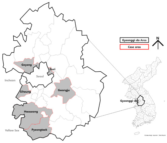
Figure 1.
Map of the locations of previous study sites.

Table 1.
Characteristics of previous study sites.
2.2. Biotope Meso-Classification Type Evaluation Grades for Previous Study Sites
Overall, a biotope map was used to evaluate the conservation value of biotopes while considering their relationship with humans [26]. The biotope taxonomy is designed to have a major-, meso-, and minor-classification system. Major- and meso-scale classifications follow the types specified by the Guidelines on Standardized Maps at the regional and national levels [23]. Therefore, it is necessary to review the grade of the meso-classification type when arranging common biotopes in order of ecological importance. First, we examined the average grade of biotope meso-classification types in six regions in the Gyeonggi Province, which experiences the highest urbanization and development pressure in South Korea. We observed the following trends: biotopes with Grade 1, which are the most stable ecosystems, including green biotopes (e.g., Natural river, Natural wetland, Natural coast, and Natural forest), to Grade 5, including urban biotopes with the lowest preservation value, tend to be rated similarly in regions (Table 2).
Table 2.
Biotope meso-classification type evaluation grade for each site.
2.3. Naturality Categorization for Each Biotope Meso-Classification Type Evaluation Grade
Table 3 presents the average grade of meso-classification biotopes in Siheung, Goyang, Gwangju, Pyeongtaek, Hwaseong, and Guri in the Gyeonggi Province. The grading system ranges from Grades 1 to 5 and is based on ecological value. Accordingly, naturality can be classified into three categories: nature, near-nature, and semi-nature.
Table 3.
Naturality categorization setting for each biotope meso-classification type evaluation grade.
- (1)
- Nature: Nature refers to an original ecosystem with significant value or potential as a biological habitat. It falls under the meso-classification biotope evaluation Grade 1, necessitating absolute preservation due to the absence of anthropogenic disturbance or long-term stability.
- (2)
- Near-nature: Near-nature characterizes an area with low intensity of land use and a close proximity to natural conditions. This category corresponds to meso-classification biotope evaluation Grades 2 and 3. Near-nature biotopes experience human interference and are sensitive to damage. However, they possess a certain level of naturality and a high potential for enhancing their ecological value through restoration efforts.
- (3)
- Semi-nature: Semi-nature denotes areas constantly affected by human interference and influence. These areas can be classified as a form of human-created nature. Semi-nature biotopes are examples of meso-classification biotope evaluation Grades 4 and 5. Their potential for regeneration into natural ecosystems is low. They exhibit excessive energy utilization and disconnected circulation systems.
2.4. Management Objectives Based on Naturality Category
In the context of landscape ecology, nature can be defined as a compilation of diverse biotopes with distinct environmental characteristics and varying spatial scales and boundaries [33]. Given the broad spectrum of biotope types, from those heavily impacted by human activities to those that are minimally disturbed, it becomes imperative to establish appropriate management goals that correspond to the level of degradation. It becomes feasible to implement ecological restoration principles based on the proximity to natural conditions, that is, based on the categorization into nature, near-nature, and semi-nature, as determined by the meso-classification evaluation grade.
Ecological restoration refers to the process of returning an ecosystem to its original state before it was impacted by external factors. This process can be categorized into different types and stages depending on the level of change and current conditions. In other words, considering the two axes necessary for an ecosystem to play an independent role in terms of function and structure, it can be divided into several types depending on the extent to which the damaged ecosystem can be restored (Figure 2) [34]. Terms commonly used to describe the preservation and restoration of biotopes are preservation, restoration, and creation [35]. The term restoration was originally derived from the term recovery; currently, various terms are used to refer to different levels of ecological restoration [36,37]. Thus, to establish management goals for different biotope types based on their naturality (i.e., nature, near-nature, and semi-nature), we propose using the concepts of preservation, restoration, and improvement within the naturality category based on ecological restoration strategy theory correlating with the function and structure of ecosystems (Table 4).
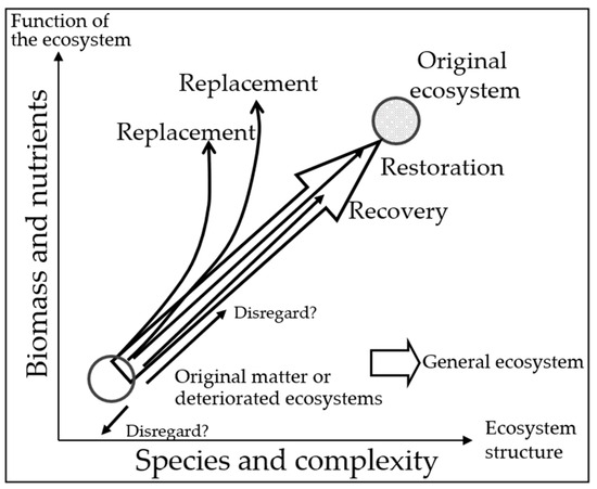
Figure 2.
Stages and types of ecological restoration [38].
Table 4.
Management goals based on the naturality category.
2.5. Biotope Meso-Classification Type Evaluation Criteria with Management Goals
After analyzing the biotope meso-classification type per grade according to the naturality category, we established the grade criteria and management goals for each type (Table 5).
Table 5.
Biotope meso-classification type evaluation grade criteria and management goal setting.
Grade 1 areas are mostly in an intact natural state and have value or high potential as biological habitats; therefore, the management goals for these areas are maintenance, protection, and recovery. Grades 2 and 3 are near-nature categories with low land use intensity, but they also include rare green biotopes, which are threatened by urbanization or haphazard development and may disappear due to high development pressure. Management goals for these grades therefore include protection, recovery, improvement, and creation. Grades 4 and 5 belong to semi-nature categories and are areas that are continuously subjected to human interference and influence. The management goals for these grades focus on improvement, creation, and reduction, such as improving urban environments, creating green spaces, and reducing pollutants.
2.6. Biotope Minor-Classification Type Evaluation Indicators
The biotope minor-classification type is based on a more detailed classification than the meso-classification type because it reflects regional characteristics of the major- and meso-classification types. The biotope meso-classification type represents standardized biotope types in a large area. The biotope minor-classification type can vary according to the unique environmental characteristics of corresponding regions. Before classifying biotope minor-classification types, evaluation criteria must be considered, that is, evaluation purposes and types corresponding to purposes must be set.
Based on the review of previous studies, we extracted the evaluation factors of minor classification types for Si-heung City, Goyang City, Gwangju City, Pyeongtaek City, Hwaseong City, and Guri City in the Gyeonggi Province and reconstructed the data using evaluation indicators. During this process, we initially sought out commonalities among the terms used in related data and utilized Hancom Office 2022 and Microsoft Excel to establish a common language. Items were grouped based on these terms, and detailed evaluation indicators were derived for each assessment item. These evaluation indicators were classified into a total of 11 evaluation items using an expert FGI (Focus Group Interview). Based on the use of a secondary FGI, the 11 evaluation items were grouped into five biotope management goals: maintenance, protection, recovery, improvement, creation, and reduction (Table 6 and Table 7).
Table 6.
FGI (Focus Group Interview) outline.
Table 7.
Setting of biotope minor classification type evaluation indicators.
The management goal for maintenance requires evaluation indicators in the category of naturality, and the management goal for protection is based on the categories of naturality, rarity, and connectivity. The management goals for recovery require the categories of recuperative ability, diversity, and vulnerability. The management goals for improvement involve the categories of ecological functionality and risk of damage. The management goals for creation are based on the categories of potential habitat, availability, and urban environment improvement functionality and the management goals for reduction involve the categories of urban environment improvement functionality. The use of evaluation indicators as the criteria for categorizing biotope minor classification types will help to clarify evaluation purposes.
2.7. Biotope-Type Classification and Evaluation Method
Biotope-type classification was used to sort out identical or similar biotopes by identifying the attributes of individual biotopes. Biotope-type classification is based on biotope attributes and environmental spatial data. Biotopes in urbanized and green areas in Dongducheon City were classified into major-, meso-, and minor-classification types based on the classification hierarchy shown in Figure 3.
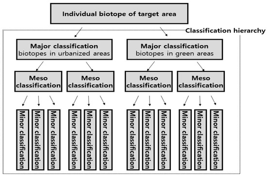
Figure 3.
Biotope type classification hierarchy.
Biotope evaluation was used to evaluate the biotope value, which is mainly expressed using a grade [39]. Grading was conducted in two steps (Figure 4): biotope meso-classification type evaluation and biotope minor-classification type evaluation. Biotope meso-classification types were assigned Grades I–V (five-grade system). Criteria for each grade are listed in Table 5. Subsequently, the purpose for each minor classification type was set (Table 7) and minor-classification type evaluation (evaluation items, evaluation indicators, and evaluation criteria) was carried out for each purpose. The minor classification type was evaluated using a three-grade system and decision tree method (Figure 5). Finally, meso- and minor-classification type evaluations were combined to categorize the final minor-classification type in Grades I–VII.
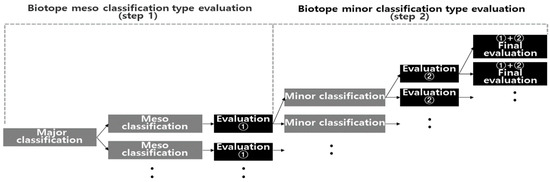
Figure 4.
Phases of biotope-type evaluation.
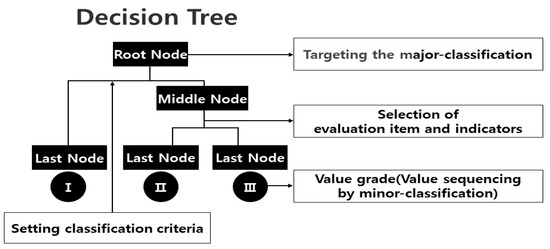
Figure 5.
Decision tree method.
2.8. Application to the Study Site
We applied the biotope map to Dongducheon City, Gyeonggi Province, including the purpose derived for each type and evaluation indicator for each purpose. The map scale is 1:5000. We created the map using the Geographic Information System (GIS) program by classifying biotope types and visualizing biotope evaluation data. The boundaries of biotopes were established by comparing with land cover map (2020), ecological and natural map (2018~2020), aerial photographs (2018, 2020), land register map (2021), topographic map (2018), building management ledger (2021), land use map (2020), urban planning map (2021), and satellite image (Google Earth Pro, 2023). Then, polygon shapes were created manually using a GIS program (Figure 6).
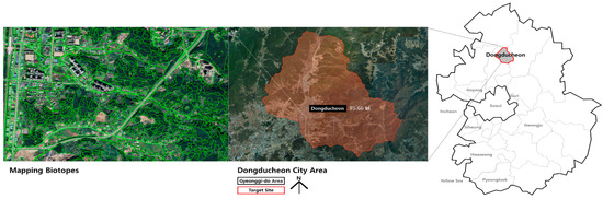
Figure 6.
Map showing the location of the study site.
We chose Dongducheon City in the Gyeonggi Province as our study location because of the lack of biotope maps available for this city. Meso-classification type evaluation, which is a standard used at local and national levels, was applied as a five-grade system and the minor-classification type evaluation (final type evaluation), which reflects the ecological characteristics of the region based on the results of the meso-classification evaluation, was applied as a seven-grade system (Figure 7).
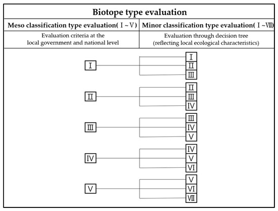
Figure 7.
Biotope-type evaluation system.
Setting management goals is crucial for the evaluation system because it determines the indicators and standards used in the evaluation [7]. For the naturality category, management goals were set in the following order: maintenance > protection > recovery > improvement > creation > reduction. The range of types, evaluation indicators, and evaluation grades were established based on these goals (Table 8).
Table 8.
Biotope-type evaluation system for Dongducheon City.
The meso-classification type evaluation grade standard suggested in Table 5 was applied. It was adjusted to fit the environmental features of Dongducheon City. The city has abundant forests. Initially, it had abundant wetlands and rice paddy fields in the lowlands. However, this area has considerably decreased due to rapid urbanization. Therefore, the grades of artificial wetland (scarce) and wet farmland (paddy fields) were raised from 2 to 1 and 3 to 2, respectively. In addition, artificial forest with low scarcity was lowered from Grade 2 to 3. Because small rivers originating from forests have excellent naturality, the small river type was upgraded from Grade 3 to 2.
3. Results
3.1. Biotope Types and Evaluation Results for Dongducheon City
The land use map, based on existing data, was revised by comparing aerial photographs, land register maps, building management ledgers, urban planning maps, and satellite images. This map and the results from the creation of the vegetation, altitude analysis, slope analysis, and aspect analysis maps required for biotope categorization are shown in Figure 8.
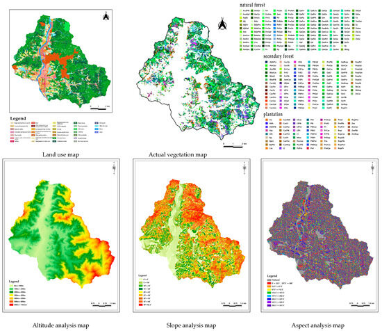
Figure 8.
Basic thematic maps for the creation of biotope maps.
Based on the biotope-type classification for Dongducheon City, 16 major, 23 meso, and 123 minor classification types were identified (Figure 9). The biotope minor classification type evaluation (final type evaluation) showed that 8, 15, 16, 18, 26, 24, and 14 biotopes belong to Grades 1, 2, 3, 4, 5, 6, and 7, respectively. Two biotopes (Construction site and development-prearranged area, Site that could not be surveyed) were excluded from the evaluation.
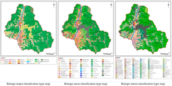
Figure 9.
Biotope-type thematic maps.
Figure 10 shows an evaluation thematic map with colored grades for the biotope minor-classification type evaluation. With respect to the proportion of the area per grade, Grades 1, 2, 3, 4, 5, 6, and 7 account for 31.27%, 12.22%, 17.20%, 12.90%, 5.61%, 7.64%, and 3.60% of the area, respectively (Table 9).
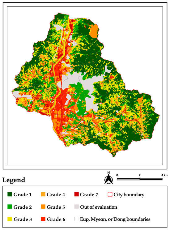
Figure 10.
Minor-classification type evaluation map (final type evaluation) for Dongducheon City.
Table 9.
Areas and percentages for each biotope minor classification type evaluation grade.
The thematic maps for biotopes according to grade are shown in Figure 11. Biotope minor-classification type evaluation Grade 1 was evaluated in 8 types, such as mountainous stream and natural forest in meso-classification. In terms of location, they are distributed where there is a high altitude and steep slope within the forest, thus maintaining its intact natural state.
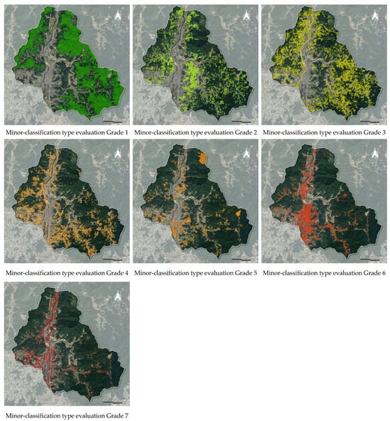
Figure 11.
Biotope minor-classification type evaluation map for each grade.
Biotope minor-classification type evaluation Grade 2 was evaluated in 15 types, such as mountainous streams in land treated for erosion control, natural wetlands, abandoned paddies, doombungs, created wetlands, natural-artificial forests, wet forests among the mountainous forests, forests with dominant natural vegetation, and large hill lands. These types are gradually decreasing and exhibit rarity. They are isolated from the city or the inside of the forest in terms of location, but they can be identified by large dots.
Biotope minor-classification type evaluation Grade 3 was evaluated in 16 types, such as water surface of artificial rivers, natural green space in the artificial rivers, artificial small rivers, small rivers for use, small rivers in land treated for erosion control, debris barriers, artificial–natural forests, forests with dominant artificial vegetation, and small hill lands. They have naturality but are damaged by humans. They are located along forest edges, while rivers pass through the city.
Biotope minor-classification type evaluation Grade 4 was evaluated in 18 types, such as created green spaces in the artificial rivers, secondary grasslands, shrub vegetation areas, dry farmland, urban parks, and buffer green spaces. They are located on the outskirts of the city and have the potential for development due to future urban expansion.
Biotope minor-classification type evaluation Grade 5 was evaluated in 26 types, such as ditches, vinyl greenhouses, campsites, golf courses, or urban areas with relatively high permeability such as residential areas, as well as commercial and business areas. Located in the city, many of these types feature green spaces created along with buildings.
Biotope minor-classification type evaluation Grade 6 was evaluated in 24 types, most of which cause urban environmental problems due to excessive energy consumption and extensive impervious pavements.
Biotope minor-classification type evaluation Grade 7 was evaluated in 14 types, such as abandoned buildings, factories, sewage treatment plants, and roads without tree-lined streets that cause the urban environment to deteriorate.
3.2. Detailed Results of Biotopes in Urbanized Areas according to Management Goals
As a result of setting the reduction management goal, meso-classification types were rated as Grade 5, classified into 9 total types. Minor-classification types were ultimately rated as Grades 5–7, classified into 20 total types. Reduction was evaluated using indicators to improve urban-environmental functions, such as installing pollution purification facilities, planting street trees, applying pervious pavement materials, and adopting green space (see Table 10 and Figure 12).
Table 10.
Biotope types and evaluation results after applying reduction (biotopes in urbanized areas).
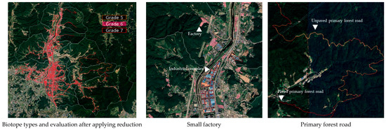
Figure 12.
Detailed biotope maps after applying reduction.
As a result of setting the management goal as creation, meso-classification types were rated as Grades 4–5, classified into 14 total types. Minor-classification types were ultimately rated as Grades 5–6, classified into 26 total types. Creation was evaluated using indicators to improve urban-environmental functions and availability, such as the ratio of permeable area through which rainwater can infiltrate, the adoption of gardens, and the provision of open spaces, green areas, and cultural functions (see Table 11 and Figure 13).
Table 11.
Biotope types and evaluation results after applying creation (biotopes in urbanized areas).
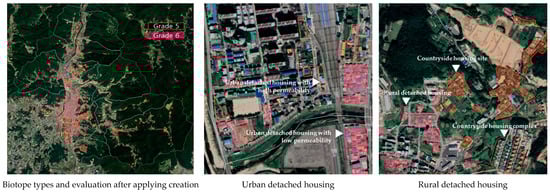
Figure 13.
Specific biotope maps after applying creation (biotopes in urbanized areas).
3.3. Specific Results of Biotopes in Green Areas According to Management Goals
As a result of setting the management goal as creation, meso-classification types were rated as Grade 4, classified into 4 total types. Minor-classification types were ultimately rated as Grades 5–6, classified into 7 total types. Creation was evaluated using indicators of reducing damage risk and increasing potential as biological habitats. These indicators included pollutant emissions, the use of area management in urban planning, and the adoption of green spaces (see Table 12 and Figure 14).
Table 12.
Biotope types and evaluation results after applying creation (biotopes in green areas).
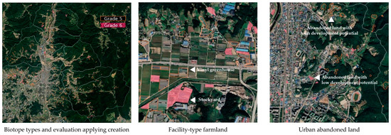
Figure 14.
Specific biotope maps after applying creation (biotopes in green areas).
As a result of setting a management goal of improvement, meso-classification types were rated as Grades 3–4, classified into 8 total types. Minor-classification types were ultimately rated as Grades 4–5, classified into 21 total types. Improvement was evaluated using indicators of improved ecological functionality and reduced damage risk, such as topography damage, green space size, use intensity, location, and wild animal movement (see Table 13 and Figure 15).
Table 13.
Biotope types and evaluation results after applying improvement (biotopes in green areas).
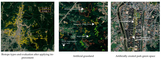
Figure 15.
Specific biotope maps after applying improvement.
As a result of setting recovery as a management goal, meso-classification types were rated as Grades 2–3, classified into 5 total types. Minor-classification types were ultimately rated as Grades 3–4, classified into 13 total types. Recovery was evaluated using indicators of reduced vulnerability and improved recuperative ability, such as artificial management strength, autogenous dominant species, and vegetation naturality (see Table 14 and Figure 16).
Table 14.
Biotope types and evaluation results after applying recovery (biotopes in green areas).
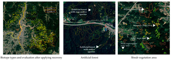
Figure 16.
Specific biotope maps after applying recovery.
As a result of setting a protection management goal, meso-classification types were rated as Grades 1–2, classified into 7 total types. Minor-classification types were ultimately rated as Grades 2–3, classified into 24 total types. Protection was evaluated using indicators of protected areas being highly rated according to naturality, rarity, connectivity, and ecological axis. These indicators include river naturality, number of polygons, hydrological control, naturality of dominant species, habitat rarity, forest size, and topography damage (see Table 15 and Figure 17).
Table 15.
Biotope types and evaluation results after applying protection (biotopes in green areas).
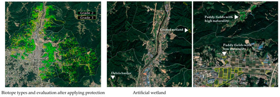
Figure 17.
Specific biotope maps after applying protection.
As a result of setting a maintenance management goal, meso-classification types were rated as Grade 1, classified into 2 total types. Minor-classification types were ultimately rated as Grades 1–2, classified into 9 total types. Maintenance was evaluated based on high naturality along with high grades in terms of preservation (see Table 16 and Figure 18).
Table 16.
Biotope types and evaluation results after applying maintenance (biotopes in green areas).
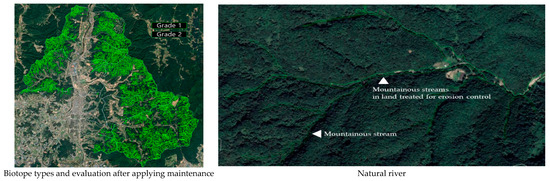
Figure 18.
Specific biotope maps after applying maintenance.
3.4. Creation of Thematic Maps Using Biotope Minor-Classification Types
If the evaluation indicators are also applied to the criteria for categorizing biotope minor-classification types, usability can be enhanced. In other words, the classification of biotope types itself can become biotope evaluation, and confirming good and bad types becomes straightforward when these types are visually represented (Figure 19). For example, in the thematic maps of urban impervious surfaces, the meso-classification types such as urban detached housing, low-rise apartment complexes, mid-rise apartment complexes, low-rise commercial business districts, and mid-rise commercial business districts were evaluated based on permeability to enhance urban environmental functions. By mapping the minor-classification types with high and low permeability, it is possible to identify areas that require improvements in permeability. Furthermore, if biotope types that positively affect the urban environment—such as wind corridors, carbon sequestration, microclimate control, groundwater content, and green corridors—are visually presented, they can be utilized for various environmental thematic maps in the future.
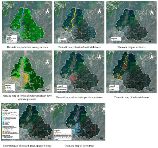
Figure 19.
Thematic maps for different biotope types.
4. Discussion
The meaning of each evaluation grade for the previous study sites was evaluated from a perspective of naturally superior biotopes (Table 17). The closer to Grade 1, the closer to conservation. Although conservative significance was confirmed, methods to manage and utilize the areas with low-graded naturality were lacking. In other words, since diverse applicability was not considered in the process of producing biotopes, they have been utilized primarily for policies that restrict development.
Table 17.
Meaning of evaluation grades for previous study sites.
Biotope maps are constructed in two stages: biotope-type classification followed by biotope evaluation. Biotope-type classification identifies the characteristics of biotopes and classifies them into major-classification → meso-classification → minor-classification [40]. The standard for classification in subdividing biotopes from meso-classification to minor-classification types is referred to as examining classification indicators. Setting the classification indicators to be the same as or similar to the evaluation indicators will facilitate biotope evaluation. In other words, biotope classification itself can be regarded as biotope evaluation. Thus, it is necessary to consider how to perform evaluation at the stage of biotope-type classification.
This study set the management goals for biotope evaluation according to type at the stage of biotope-type classification and provided a biotope-type classification and evaluation method by applying evaluation indicators to meet the management goals.
The results of the biotope evaluation after applying the management goals for each type were as follows. Biotope types for maintenance were rated as Grade 1. Although Dongducheon City belongs to the Gyeonggi Province, which includes large cities and active development, 65% of the city is covered by forest. These forests exist on a large scale above a certain size, and large patches have important ecological value because they create diverse microhabitats that protect water quality, connect water systems, maintain populations of internal species, provide a habitat for wild animals, and serve as a source of species [41]. Numerous valuable biotope types were identified in the province including natural forests, which are in pristine state and account for 50.61%. They also include habitats with natural rivers flowing within forests, leading to a high biodiversity. Most of them are located at high altitudes. Therefore, they are difficult to access and are managed based on various development regulations. These types will likely remain in their current state.
Biotope types for protection were rated as Grades 2 or 3. The number of these biotope types is gradually decreasing despite their ecological values. Kim [42] analyzed the fragmentation levels of green space biotopes through biotope maps and found a gradual increase in small green space biotope patches, indicating habitat fragmentation. Hwang [43] noted that corresponding types have high carbon storage capacity, and Kim [44] identified them as places generating cold air in a city or serving as wind corridors. Examples include lowland wetlands, forest edges close to cities, and forests fragmented by roads and cities. These types require protection measures because they are at risk of damage due to their proximity to cities. Therefore, we applied evaluation indicators that can reduce or recover from damage. If wetlands naturally retain water, forest edges restore damaged vegetation, and fragmented forests are connected, they were assigned to Grade 2. Otherwise, they were categorized as Grade 3.
Biotope types for recovery were evaluated as Grades 3 and 4. These types retain naturality to some extent. Examples include rivers in urban centers and forests or grasslands that have been damaged. We applied evaluation indicators that should be recovered to a state similar to nature by reducing artificial factors. Rivers are pivotal in the urban environment, but most rivers in Dongducheon City are artificially damaged. River biotopes can serve as habitats for birds, and Chae [45] found that river biotopes support diverse types of birds due to abundant insects. Han [46] confirmed a higher number of individuals in larger biotopes. Kim [47] indicated that these biotopes are crucial for regulating the urban microclimate. Therefore, evaluations can be based on the intensity of anthropogenic management. Grade 3 was assigned if the area of artificial structures was smaller or that of natural vegetation was larger and Grade 4 was used if the area of natural vegetation was smaller.
Biotope types in which the ecological quality should be improved were rated as Grades 4 and 5. Typical examples are urban parks and man-made green spaces. Grade 4 was assigned if the green spaces were larger, green spaces were connected or created, wild animals could move, and buffer functions existed related to the risk of damage to the surroundings. Otherwise, they were evaluated as Grade 5.
Biotope types for the creation category were rated as Grades 5 and 6. These types enhance environments based on the creation of green areas along with artificial elements in a city to improve the urban environment. Kang [48] suggested that there should be measures to increase groundwater storage, and Yoon [49] indicated that these types can lower temperatures and increase thermal comfort in a city. Grade 5 was assigned if green areas were identified around buildings or facilities, such as residential, commercial, and business buildings; the percentage of green areas was high, and rainwater collection and infiltration were possible. Otherwise, Grade 6 was assigned.
Biotope types for the reduction category were rated as Grades 6 and 7. Because these types are affected by contamination that degrades the environmental quality, measures should be implemented to reduce negative impacts. Examples include factories, power generation facilities, roads, parking lots, and railroads, which generate pollutants. Grade 6 was assigned if a purification facility was identified or a buffer function existed based on green areas. Otherwise, the biotope type was rated as Grade 7.
This study has several limitations. First, the management goals for each biotope type could be more diverse. It is difficult to generalize the management of biotope types because of regional, environmental, and institutional differences. However, considering that appropriate management targets were established for each damage level in correlation with the ecological value, it is important to emphasize how a biotope map that includes purposes can be created. Second, it is necessary to develop and supplement new indicators for the evaluation of each management goal. In this study, biotope evaluation factors were extracted from previous studies. All biotope types require indicators that can be used to clearly evaluate their status. Third, more objective evaluation criteria should be utilized when evaluating biotope types using indicators. Because biotope types are diverse and field surveys are limited, the coverage of accurate attributes for all biotope types is restricted. Therefore, it is necessary to reduce the intensity of fieldwork, add verifiable attribute data to biotope objects, and supplement criteria for evaluation with objective figures based on attribute data.
5. Conclusions
This study attempted to suggest a biotope mapping method to utilize the biotope map for environmentally friendly urban development in various ways.
First, we derived the management goals for each biotope type with ecologic value. The biotope types were categorized into nature, near-nature, and semi-nature according to the damage level. Because several types can easily be returned to their original state and other types cannot be returned to their original state due to severe damage, it was necessary to establish strategies according to the ecological value. Therefore, biotopes were reorganized based on low and high ecological values, and management goals were derived in the following order: maintenance, protection, recovery, improvement, creation, and reduction.
Second, we derived evaluation indicators for each management goal. They can be easily applied when setting purposes through biotope evaluation. Evaluation indicators were required to achieve the management goals of maintenance, protection, recovery, improvement, creation, and reduction. We extracted biotope evaluation factors from previous studies and processed the data with evaluation indicators. The derived indicators were categorized into 11 evaluation items by conducting an expert FGI: diversity, urban environment improvement functionality, recuperative ability, potential habitat, ecological functionality, connectivity, availability, naturality, vulnerability, risk of damage, and rarity. These evaluation items were classified into the five management goals of biotopes using the second FGI. Thus, the previous study suggested evaluation of Grades 1 to 5, but this study evaluated them more broadly from Grades 1 to 7 and improved the usefulness by further segmenting grades 4 and 5 of the previous study (mostly developed or in urban areas where biotopes are important to the urban environment, but are undervalued in the evaluation of biotope-type). The directions for the utilization of each grade were presented by reflecting the evaluation grade and management goals.
Third, the suggested biotope mapping method was applied to the biotope map of Dongducheon City, Gyeonggi Province. Biotope types were classified into 16 major-, 23 meso-, and 123 minor- classification types. The biotope evaluation showed that 8 (31.27%), 15 (12.22%), 16 (17.20%), 18 (12.90%), 26 (5.61%), 24 (7.64%), and 14 (3.60%) biotope types belong to Grades 1 through 7, respectively. Two types (9.56%) were excluded from the evaluation. The biotope type for maintenance was classified as Grade 1, the biotope type for protection as Grades 2 and 3, the biotope type for improvement as Grades 4 and 5, the biotope type for creation as Grades 5 and 6, and the biotope type for reduction as Grades 6 and 7; the management direction for each biotope-type was also presented.
This study suggested a biotope mapping method for all biotope types comprising the biotope map to be applied in various ways from the perspective of environmentally friendly urban development. Previous studies primarily focused on deriving an excellent natural environment by evaluating the conservation value, which led to a limitation: limited utilization as a means of development restriction and regulation. This study is significant in that it set management goals and suggested evaluation indicators for achieving these goals at the biotope-type classification phase, which is the biotope production process. This approach can facilitate the implementation of future management measures per type. Moreover, this study considered biotope mapping methods for a biotope map to be applied to environmental planning in a city.
Author Contributions
Conceptualization, T.K. and G.K.; methodology, T.K. and G.K.; software, T.K. and G.K.; data curation, T.K.; writing—original draft preparation, T.K. and G.K.; writing—review and editing, T.K. and G.K.; visualization, T.K.; supervision, G.K.; project administration, G.K. All authors have read and agreed to the published version of the manuscript.
Funding
This research received no external funding.
Data Availability Statement
The data presented in this study are available upon reasonable request from the corresponding author. The data are not publicly available due to privacy restrictions.
Conflicts of Interest
The authors declare no conflicts of interest.
References
- Keller, D.R.; Golley, F.B. The Philosophy of Ecology: From Science to Synthesis; University of Georgia Press: Athens, GA, USA, 2000; p. 114. [Google Scholar]
- Sukopp, H.; Weiler, S. Biotope mapping and nature conservation strategies in urban areas of the Federal Republic of Germany. Landsc. Urban Plan. 1988, 15, 39–58. [Google Scholar] [CrossRef]
- Schaefer, M. Ökologie. In Wörterbücher der Biologie, 3rd ed.; Gustav Fischer: Stuttgart, Germany, 1988; p. 433. [Google Scholar]
- Hwa, R.J. A study on the urban mapping (UBM) and a building of biotope information system (BIS) as a specialized tool in urban landscape planning. J. Korean Inst. Trad. Landsc. Archit. 1997, 15, 133–145. [Google Scholar]
- Arbeitsgruppe Methodik der Biotopkartierung im besiedelten Bereich. Flächendeckende Biotopkartierung im besiedelten Bereich als Grundlage einer am Naturschutz orientierten Planung. Programm für die Bestandsaufnahme, Gliederung und Bewertung des besiedelten Bereichs und dessen Randzonen. Nat. Landsch. 1993, 68, 492–526. [Google Scholar]
- Blab, J.; Riecken, U.; Ssymank, A. Proposal on a criteria system for a National Red Data Book of Biotopes. Landsc. Ecol. 1995, 10, 41–50. [Google Scholar] [CrossRef]
- Spellerberg, I.F. Evaluation and Assessment for Conservation: Ecological Guidelines for Determining Priorities for Natural Conservation; Champman & Hall: London, UK, 1992; p. 260. [Google Scholar]
- Ratcliffe, D.A. A Nature Conservation Review; Cambridge University Press: Cambridge, UK, 1977; Volume 1, pp. 6–10. [Google Scholar]
- Auhagen, A.; Sukopp, H. Ziele, Begründungen und Methoden des Naturschutzes im Rahmen der Stadtentwicklungspolitik von Berlin. Nat. Landsch. 1983, 58, 9–15. [Google Scholar]
- Johnston, J. Nature Areas for City People. A Guide to the Successful Establishment of Community Wildlife Sites; Ecology Handbook 14; London Ecology Unit: London, UK, 1990; p. 116. [Google Scholar]
- Plachter, H. Methodische Rahmenbedingungen für synoptische Bewertungsverfahren im Naturschutz. Z. Ökol. Naturschutz. 1994, 3, 87–106. [Google Scholar]
- Marsh, S. Nature Conservation in Community Forests; Ecology Handbook 23; London Ecology Unit: London, UK, 1994; p. 64. [Google Scholar]
- Caldecott, J.O.; Jenkins, M.D.; Johnson, T.; Groombridge, B. Priorities for Conserving Global Species Richness and Endemism; World Conservation Monitoring Centre (WCMC) Biodiversity Series No. 3; World Conservation Press: Cambridge, UK, 1994; p. 36. [Google Scholar]
- Dierßen, K.; Roweck, H. Bewertung im Naturschutz und in der Landschaftsplanung. In Integrative Umweltbewertung; Theorie und Beispiele aus der Praxis; Theobald, W., Ed.; Springer: Berlin/Heidelberg, Germany, 1998; pp. 175–192. [Google Scholar]
- Choi, S. Study of Environmental Impact Assessment Techniques for Forest Ecosystems: Focus on the Evaluation of the Naturality of Green Spaces. Ph.D. Thesis, Graduate School of University of Seoul, Seoul, Republic of Korea, 1996; p. 149. [Google Scholar]
- Kwon, J. A Study on the Ecological Evaluation for the Nature-Friendly Residential Site Development Planning. Ph.D. Thesis, Graduate School of University of Seoul, Seoul, Republic of Korea, 2003; p. 281. [Google Scholar]
- Kim, J. Ecological Land Use Planning Considering the Characteristics of Urban Ecosystem: A Case Study of Hanam, Kyeonggi Province. Ph.D. Thesis, Graduate School of University of Seoul, Seoul, Republic of Korea, 2005; p. 271. [Google Scholar]
- Choi, J. Development of Classification and Evaluation Process of Biotope Type by Suitable Regional Characteristics in Seoul. Ph.D. Thesis, Graduate School of University of Seoul, Seoul, Republic of Korea, 2009. Metropolitan Area: Korea. pp. 161–162. [Google Scholar]
- Seoul Metropolitan Government. Biotope Status Survey and Establishment of Ecological City Creation Guidelines for Application of Urban Ecology Concept to Urban Planning for Seoul; Seoul Metropolitan Government: Seoul, Republic of Korea, 2001. [Google Scholar]
- Kim, H.; Lee, Y.; Choi, J.; Kwon, H. A Study of the Creation and Operation Method of Urban Ecological Maps for Basic Local Governments in Gyeonggi Province; Gyeonggi Research Institute: Pangyo, Republic of Korea, 2020; p. 135. [Google Scholar]
- National Institute of Ecology. Natural Environment Survey-Related System and Operation Casebook of Germany; National Institute of Ecology: Seocheon County, Republic of Korea, 2019. [Google Scholar]
- Song, I. Environmentally Friendly Urban Management Using Biotope Maps; The Seoul Institute: Seoul, Republic of Korea, 2016; p. 2. [Google Scholar]
- Ministry of the Environment. Guidelines on How to Create an Urban Ecological Map; Ministry of the Environment: Sejong, Republic of Korea, 2021; p. 19. [Google Scholar]
- Sukopp, H.; Kunick, W.; Schneider, C. Biotope mapping in the built-up areas of West Berlin. Part II. Field methods and evaluation. Gart Landsch. 1980, 7, 565–569. [Google Scholar]
- Cairns, J., Jr. Is restoration ecology practical? Restor. Ecol. 1993, 1, 3–7. [Google Scholar] [CrossRef]
- Kim, H. Classification Biotope Type and Evaluation Value of Individual Biotope: Landscape Ecological Approaches. Ph.D. Thesis, Graduate School of Dongguk University, Seoul, Republic of Korea, 2012; p. 46. [Google Scholar]
- Siheung City. Service for Ecological Survey and Urban Ecological Map Creation; Siheung City Council: Siheung, Republic of Korea, 2020; pp. 147–171. [Google Scholar]
- Goyang City. Urban Ecological Map Reorganization Service for Goyang City; Goyang City Council: Goyang, Republic of Korea, 2022; pp. 207–218. [Google Scholar]
- Gwangju City. Academic Service for Creating Gwangju City Urban Ecological Map; Gwangju City Council: Gwangju, Republic of Korea, 2021; pp. 303–311. [Google Scholar]
- Pyeongtaek City. Service for Pyeongtaek City Urban Ecological Map Creation and Web GIS System Construction; Pyeongtaek City Council: Pyeongtaek, Republic of Korea, 2021; pp. 262–274. [Google Scholar]
- Hwaseong City. Service for Hwaseong City Ecological Urban Map Creation; Hwaseong City Council: Hwaseong, Republic of Korea, 2021; pp. 241–252. [Google Scholar]
- Guri City. Research Service for Creating Guri City Urban Ecological Map; Guri City Council: Guri, Republic of Korea, 2022; pp. 266–275. [Google Scholar]
- Knickrehm, B.; Rommel, S. Biotoptypenkartierung in der Landschaftsplanung. Anforderungen an Einen Kartierschlüssel vor dem Hintergrund der Lokalen Landschaftserfassung. Bachelor’s Thesis, Leibniz University of Hanover, Hannover, Germany, 1994; p. 169. [Google Scholar]
- Cho, D. Concept and Considerations of Ecological Restoration. 1990, p. 34. Available online: https://search.naver.com/p/crd/rd?m=1&px=408&py=216&sx=408&sy=216&p=iCf5twpzLiwssvCzd1ZssssstsC-253891&q=%EC%83%9D%ED%83%9C%EB%B3%B5%EC%9B%90%EC%9D%98+%EA%B0%9C%EB%85%90%EA%B3%BC+%EA%B3%A0%EB%A0%A4%EC%82%AC%ED%95%AD&ie=utf8&rev=1&ssc=tab.nx.all&f=nexearch&w=nexearch&s=%2BKfPVsyv6RqwSa3belyiow%3D%3D&time=1715767562645&abt=%5B%7B%22eid%22%3A%22PTC-DEL-FEAT%22%2C%22vid%22%3A%226%22%7D%5D&a=web_gen*w.pdf&r=0&i=a00000fa_c5e090857a7c6e2196b711d0%5EDG&u=http%3A%2F%2Fwww.koreascience.or.kr%2Farticle%2FJAKO200251922814768.pdf&cr=1 (accessed on 13 May 2024).
- Seoul Metropolitan Government. Measures to Promote Biodiversity per Biotope Type for Seoul; Seoul Metropolitan Government: Seoul, Republic of Korea, 2004. [Google Scholar]
- Kim, G.; Jo, D. Principles of Natural Environment and Ecological Restoration; Academy Book: Seoul, Republic of Korea, 2004. [Google Scholar]
- Lee, E. A Planning for Substitute Habitats by the Habitat Types in Urban. Acad. Present. Pap. Korean Soc. Plant Environ. Des. 2008, 129–131. [Google Scholar]
- Bradshaw, A.D. The biology of land restoration. In Applied Population Biology; Jain, S.K., Botsford, J.W., Eds.; Kluwer Academic Publishers: Dordrecht, The Netherlands, 1992; pp. 25–44. [Google Scholar]
- Seoul Development Institute. A Detailed Survey Study on Excellent Ecosystem Areas in Seoul; Seoul Metropolitan Government: Seoul, Republic of Korea, 2001; p. 641. [Google Scholar]
- Ministry of the Environment. Urban Ecological Map Creation Manual; Ministry of the Environment: Sejong, Republic of Korea, 2019; p. 3. [Google Scholar]
- Hansson, L.; Angelstam, P. New ecological processes in small reserves. In Nature Conservation; Svensson, L., Ed.; National Swedish Environmental Protection Board, Research Secretariat: Solna, Sweden, 1988; pp. 25–32. [Google Scholar]
- Kim, J.H.; Na, J.H.; Lee, S.J.; Gwon, O.S.; Lee, E.J. Analysis of Green Spaces Biotope Fragmentation Patterns in Daejeon Metropolitan City via Landscape Indexes and Visualization Techniques. J. Korean Soc. Environ. Restor. Technol. 2016, 19, 29–44. [Google Scholar] [CrossRef][Green Version]
- Jeon, S.-W.; Hwang, J.-H.; Jang, R.-I. A Study on the Estimation Method of Carbon Storage Using Environmental Spatial Information and InVEST Carbon Model: Focusing on Sejong Special Self-Governing City—Using Ecological and Natural Map, Environmental Conservation Value Assessment Map, and Urban Ecological Map. J. Korea Soc. Environ. Restor. Technol. 2022, 25, 15–27. [Google Scholar]
- Kim, Y.M.; An, S.M.; Moon, S.Y.; Kim, H.S.; Jang, D.H. Wind corridor analysis and climate evaluation with Biotop map and airborne LiDAR data. J. Korean Instit. Landsc. Architect. 2012, 40, 148–160. [Google Scholar] [CrossRef][Green Version]
- Chae, J.H.; Koo, T.H. Development of Biotope evaluation indexes for improving bird diversity. J. Environ. Policy 2005, 4, 113–127. [Google Scholar]
- Han, B.H.; Choe, J.U.; Kim, J.S.; No, T.H. A study of Wildbird habitat characteristics on Biotope type of stream—In case of Seom River and Wonju stream, Wonju. Acad. Present. Pap. Korean Soc. Environ. Ecol. 2009, 2, 177–181. [Google Scholar]
- Kim, J.H.; Yoon, Y.H.; Joo, C.H. Biotope Map Utilization Plan for Urban Management in Response to Climate Change Impacts (1): Analysis of thermal environment change factors per biotope type. Acad. Present. Pap. Korean Environ. Sci. Soc. 2011, 20, 477–478. [Google Scholar]
- Kang, D.H.; Park, I.H.; Kim, J.H.; Lee, S.J.; Kwon, O.S. Ecosystem service valuation on groundwater storage capacity by Biotope type. J. Korea Soc. Environ. Restor. Technol. 2017, 20, 1–13. [Google Scholar]
- Yoon, Y.-H.; Joo, C.-H.; Kim, J.-H. Improvement of environmental comport by land-use using bioclimatic chart. J. Korean Reg. Dev. Assoc. 2011, 23, 39–58. [Google Scholar]


Disclaimer/Publisher’s Note: The statements, opinions and data contained in all publications are solely those of the individual author(s) and contributor(s) and not of MDPI and/or the editor(s). MDPI and/or the editor(s) disclaim responsibility for any injury to people or property resulting from any ideas, methods, instructions or products referred to in the content. |
© 2024 by the authors. Licensee MDPI, Basel, Switzerland. This article is an open access article distributed under the terms and conditions of the Creative Commons Attribution (CC BY) license (https://creativecommons.org/licenses/by/4.0/).