Abstract
This paper explores the relationship between territory and urban space, discussing the joint development processes of urban and territorial morphologies. The paper argues that territorial structure is a precursor to urban design. It also discusses how landscape architecture can respond to the morphological needs of contemporary urban design as the boundaries between city and territory merge. The introduction and framework review section examines various approaches to studying the relationship between urban morphology and interstitial spaces or unbuilt geographies, which are often still considered empty spaces, physically incorporated but excluded from urban design. It also briefly discusses the role that green spaces and territorial morphologies have played, or not played, in defining urban form from antiquity to modernity. The paper then focuses on the role of hydromorphologies in shaping the urban form of Rome, Boston and Bari. These cities are analyzed as case studies to discuss 20th-century approaches to urban planning in relation to territorial layout. Finally, this study analyzes a marginal area of the metropolitan city of Bari in order to propose possible landscape morphologies of reconnection for the resulting interstitial areas.
1. Introduction
At a time when growing urbanization has erased the boundaries between the city and its surroundings, urban and metropolitan landscapes appear as vast natural and man-made networks in which all elements participate in the making of the urban form. This new dimension opens up urban layouts intertwined with territorial morphologies that periodically claim the boundaries or interstitial spaces of metropolitan agglomerations. In this framework, the changing declinations of the relationship between cities and landforms raise complex issues, not only in terms of urban morphology but also in terms of ecological and hydrogeological order, which are becoming increasingly relevant due to human-induced climate change. Today’s urban landscape seems to be characterized by the dispersed urbanization of the urban sprawl within the metropolitan dimension, urban–rural fringes, interstices, urban agriculture, green belts, wilderness [1], and by the presence of several different uses and forms of agricultural and natural fabrics, including—but not limited to—farmlands, geographical buffers, brownfields, historic parks, rivers, seashores and lakes or wetlands that have been left within the urban area as part of its development.
All these urban areas are often classified according to their functions (infrastructure, agriculture, public facilities, protected ecosystems, safety buffers, or brownfields), and in planning, these areas are mainly considered as suburban gaps [2]. In recent decades, several terms have emerged to define them, including non-places [3], terrain vague [4,5], non-urbanized areas [6,7], wildscapes [8], drosscapes [9], wastelands [10], urban interstices [11] and interstitial landscapes [12,13]. Although these categories of spaces are often described as voids or unconnected interstices without potential, the morphology of the 21st-century city is increasingly shaped by their presence.
The contemporary urban landscape establishes new relationships with the countryside and with the natural elements that innervate the sparse urban landscape of the suburbs [14], and it is characterized by a mixture of built fabrics and pieces of natural and agricultural fabrics that punctuate them, especially along rivers, lakes or seashores or where, for hydrogeological reasons, it is difficult to settle. This defines apparently disordered urban and metropolitan landscapes, which are in fact rich in resources, values and elements to be valorized, reconsidered and reconnected to the urban fabric, within a sustainable and ecological urban vision.
The urban landscape is now a complex and multidimensional phenomenon, encompassing and linking built, undeveloped, agricultural and natural spaces; it is also defined by increasing patterns of multifunctionality, polycentricity and self-sufficiency, especially in light of adaptation to climate change [15].
This new dimension and complexity opens up the need for new coherent relationships with the surrounding territory, with the interstitial rural and natural fabrics, as well as with the numerous ecosystems that permeate the urban layout. In addition to ecological, social or economic issues [15] and hydrogeological aspects, which are becoming increasingly relevant due to the ongoing climatic changes [16], the new urban dimension reconnects with the landscape and induces spatial transformations that assign new forms and roles to open spaces in interstitial or marginal areas. Therefore, the project for the city of the 21st century cannot be conceived only in relation to the morphology of the urban fabrics, but it must be conceived in relation to the characteristics of the surrounding territorial organism [17], whose structure, invariable and difficult to modify, has defined and directed the expansion and the limits of the existing urban fabric over time. Within this framework, the role of landscape design becomes increasingly important in the creation of healthy and multilayered urban landscapes, as well as in the design of public spaces at the interface between urban and rural areas, with the aim of combining environmental and urban form, natural and built environment in a unique morphology that gives order to the metropolitan dimension.
In these marginal and interstitial areas, landscape architecture and urban design are intimately linked, so that the quality of one also depends on the value of the other: urban design focuses on the design and shaping of the built areas of urban and territorial spaces; landscape architecture also considers issues of environmental and ecological value and the inter-scalar interconnection of natural and anthropic resources. Dealing with the analysis and design for the management and transformation of landscapes and open spaces, landscape architecture requires a keen understanding of urban and territorial morphology [17], as well as of a wide range of subjects, ranging from physical geography to ecology and water management [18], with the aim of creating sustainable and inclusive cities. Therefore, it can play an important role in defining the urban form, especially when the city meets with intermediate or peripheral rural areas, and correlates with sustainable processes of change in social, economic and environmental development.
The aim of this paper is to focus on the relationship between territory and urban space, describing the origins, theories and examples of a common design between urban and territorial morphologies. It also aims to show how the design of interstices and peripheries can contribute to the definition of urban landscape forms adapted to the local environment and thus become the new hubs of the city of the 21st century. Accordingly, the set of natural and rural areas embedded in metropolitan morphologies are considered not only as voids but as structural components of the territorial layout, which were later incorporated into the sprawl of the 21st-century city, and which today contribute to the definition of its multilayered and multicomposed urban morphology. Therefore, the paper assumes that the understanding of the characteristics of the territorial structure is a prodromal act of design. Evidence related to the origin of the apparently disordered urban morphology of the case studies of Rome, Boston and Bari (Figure 1) will describe how the presence of rivers, coastlines, or hydrogeological constraints define diverse connections between city and landscape. To understand the apparent anomalies in the urban morphology of their metropolitan areas, we need to analyze these conditions and clarify their implications for urban and landscape design.
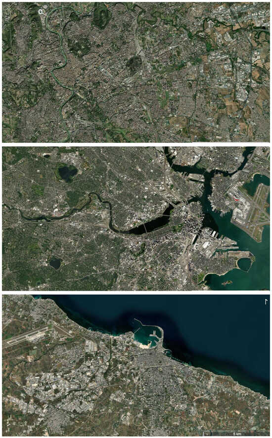
Figure 1.
General satellite view of Rome, Boston and Bari on a metropolitan scale.
New urban morphologies and visions proposed by landscape design for parks and mixed-use areas, related to the case study of Bari, will show how the presence of rivers, lakes, seashores or hydrogeological constraints can enrich the connections between city and territorial layout, opening to new morphologies for the 21st-century city.
With a focus on open spaces and the transdisciplinarity between landscape design and morphological studies, this paper ultimately aims to shift the perspective from urban to urban landscape morphology as a tool for understanding urban growth, adaptation and future transformation.
A sound urban landscape design means dealing with territorial processes, understanding their formative and transformative processes, and consciously moving beyond the boundaries of cities and territories to face this complex urban dimension.
2. Materials and Methods
2.1. Framework Review: Terms and Definitions
In research on urban morphology and design, there is still a lack of attention to unbuilt geographies: undeveloped land and open spaces are often seen as gaps that are physically embedded but excluded from urban morphology.
These interstitial spaces often define the fragmented nature of sprawl, within urban landscapes that emerge as somehow undetermined or unplanned, as the result of less controlled planning processes, or as reclaimed land to be urbanized. In the understanding of sprawl [19], they remain as undefined elements, as unexplored ecosystem services [6,20], as informal green infrastructure [21], or simply as vacant land [22].
Also, the definition of urban sprawl, a dispersed growth where traditional suburban development is enriched by economic and functional self-sufficiency [23], is mainly related to the impact of built areas on the urban form, rather than encompassing unbuilt geographies, agricultural or natural areas scattered in the urban fabric, which instead define morphological and functional aspects of the surrounding environment: Pieces of countryside, brownfields, farmlands, forests, geographical restrictions and protective buffers, green corridors and other entities are still defined as urban gaps between planned and unplanned areas.
In fact, these interstitial spaces are often triggered by different territorial factors and have different impacts on the urban form to which they are concretely linked. A deeper understanding of the territorial organism reveals them as active elements in the definition of urban and territorial sustainability, connecting separated territorial units and often bringing resources to the urban area.
In the city of the 21st century, the understanding of the behavior of the territorial organism is one of the most important tests of the new morphological discipline: at a moment when the city and the territory are merging, the design of interstitial morphologies, together with environmental and ecological studies, has become the essential tool for urban sustainability, with the aim of collecting, preserving and sustainably using locally available resources. Moreover, at a time when the energy crisis is driving a growing social awareness of individual responsibility in the sustainable use of local resources, a landscape morphology approach is needed to provide effective tools for finding new site-specific solutions, with the aim of fully exploiting all the possibilities offered by the development of techniques and environmental analysis.
This is particularly relevant in the case of metropolitan areas and medium-sized cities, which are in direct contact with natural territorial structures and fragments of agrarian fabrics that seem to have an unplanned urban form or layout, often derived from underlying territorial conditions. Here, the mix of values (urban, rural, environmental, cultural, heritage) that characterizes the urban morphologies creates apparently sprawling metropolitan landscapes that are in fact urban environments rich in resources and elements that need to be enhanced, reconnected and rethought within a consistent perspective of the relationship between urban and territorial form that has open space design at its core.
In these cases, urban analysis can help to understand and reveal the hidden territorial layout and to adopt and implement integrated strategic plans to improve the relationship between the different systems of the urban environment [24]. This mixture is the result of different planning ideas and spontaneous growth [25] that followed, overlapped and juxtaposed each other over time, in relation to different cultures and societies, and defined the urban form until the 20th century, when the urban sprawl began to be guided by the territorial layout. Although the project of the twentieth-century city envisaged an urban development based on formal research, often indifferent to the territorial context [26], its implementation had to collide and adapt to the territorial layout, and in particular to hydrogeological and orographic constraints. Over time, this has defined the irregular morphology of the contemporary city, with which the design of public spaces must now contend.
2.2. Background: From the Compact City to Landscape Urbanism
Therefore, in order to develop strategies, theories and techniques aimed at proposing an integrated development between urban and rural areas, built and natural environment, it may be useful to briefly trace the links between urban form and territorial environment in urban design.
To date, urban historiography has probably not sufficiently emphasized the primary role that gardens and natural areas have played in defining urban form. While it is clear that urban civilization rose with agriculture, and that this relationship of dependence of urban areas on the surrounding territory has been described quite well enough for the eastern cities [27,28], especially in relation to water supply, there is still a lack of interest in studying the relationship of dependence between urban form and the surrounding territorial layout in the western regions. Instead, this is quite strong, especially in relation to the availability of agricultural land and environmental resources, including water flows, orographic structures, coastal morphology, or constraints such as wetlands and surface hydrographic systems [25,26].
In other words, in order to face with greater awareness the design of the city of the 21st century, it is now time to rethink the history of urban development, emphasizing the role that agricultural areas and natural elements within cities, together with the surrounding resources, have played in defining and shaping the urban form.
Recent archaeological research is increasingly revealing traces of green or agricultural areas, orchards, vineyards, gardens and parks, within or just outside the walls of ancient and medieval cities.
This is the case, for example, of the Forum Boarium in Pompeii (Figure 2), which (despite its current name) was actually a vineyard located near the city walls and several domus with large gardens.
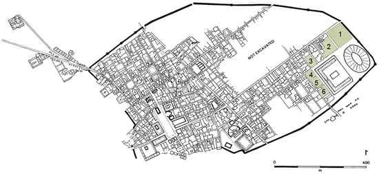
Figure 2.
Map of the excavated area of Pompeii. 1. Forum Boarium; 2. House of Octavio Quartio; 3. Praedia of Giulia Felice; 4. House of the Triclinium outdoor or summer; 5. House of Floral Lararium; 6. House of the Garden of Hercules.
It is also the case of the system of Arab–Norman parks in Palermo, where the Muslims, during their rule over Sicily, transformed the rich agrarian landscape of the valley into a vast productive garden made up of agricultural areas and a series of royal urban parks (Figure 3), thanks to the use of agricultural techniques widely developed and shared in the Arab and Persian world [29].
Figure 3.
The system of parks in the Arab–Norman Palermo in relation to the river and the sea. The map shows in dark grey the urban fabric extension of the Norman Palermo; in blue the Kemonia and Papireto torrents; in green the hypothetical area of the three main parks of the Norman–Arab Palermo, which occupied a wider area than the city itself (Diagram after [29]).
While within the medieval city walls of many European cities one can still read the traces of the private gardens that were used as reserves of forced seclusion, and along the city walls one can still see the traces of the fields and vineyards that surrounded the monasteries located on the outskirts of the city, the densification of the urban fabric erased most of the traces of these areas, thus increasing the gap between city and countryside, often leaving only the green areas that were difficult to settle for hydrological reasons unbuilt.
Nineteenth-century urban development resulted in the configuration of the industrial city, where, except for a few reformist utopias, the presence of trees and greenery in public spaces was rare.
Finally, the twentieth-century city was the final result of urban development at the expense of the rural fabric, and the neighborhoods were embedded in extra-urban boulevards that connected urban nuclei to rural villas and farms, often aligned along these territorial routes, which are still interspersed with agricultural areas.
In general, nineteenth- and twentieth-century urban theories did not pay much attention to the role and impact of the territorial layout on urban development; rather, they interpreted the landscape as a kind of backdrop against which to set their visionary projects.
The pioneer of urban ecology, Patrick Geddes, would lay the groundwork for a humanistic matrix of urbanism (Figure 4) embedded in the context of the land [30]. At a time when ecology was developing as an autonomous discipline, Geddes invented concepts such as bioregionalism, the conurbation, or the educational garden, emphasized the need to cultivate and maintain green belts, and greatly influenced the garden city movement founded by Ebenezer Howard.
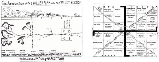
Figure 4.
Diagrams after “Cities in Evolution” by Patrick Geddes.
Nevertheless, even in the theories of the Garden City [31] at the end of the 19th century (Figure 5), the utopian diagram did not resolve the relationship with the environment and had to be adapted to the chosen site without further specifications. The abstraction of the Concentric Zone Model [32] in the 1920s, the Sector Model [33] in the 1940s, and the Multiple Nuclei Model [34] in the 1950s was no different. All these urban utopias described the structure of the urban form without mentioning possible adaptations to environmental and territorial morphologies.
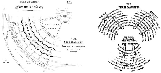
Figure 5.
Diagrams after “The Garden City” by Ebenezer Howard.
Also for the City of Tomorrow [35] and the Broadacre City [36] (Figure 6), the surrounding flat territory was kept as a given framework, focusing on architecture and urban design without developing models, taking into account a series of possible adaptations to variants of territorial morphology.
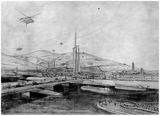
Figure 6.
A view of the “Broadacre City” by Frank Lloyd Wright.
On the other hand, in the United States, at the turn of the century, the city beautification movement developed with public works, parks, gardens, public and private buildings of remarkable architectural commitment. Although everything was designed in an urban context overseen by the means of architectural design, in the 1909 Plan of Chicago (Figure 7), Daniel Burnham and Edward H. Bennett, assisted by Frederick Law Olmsted for landscape design, sought to beautify Chicago and improve the efficiency of commerce and transportation. The plan also called for the improvement of the city’s 25 miles of lakefront as public parkland, the acquisition of an outer park system, and the creation of parkway circuits linking otherwise unconnected urban and metropolitan areas [37].
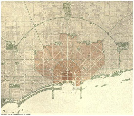
Figure 7.
Chicago. “Plan of the city, showing the general system of boulevards and parks” by Daniel Burnham and Edward H. Bennett.
This lack of connection between city and territory, architecture and landscape, which essentially disappeared in the postwar period with the exponential growth of the metropolis, further faded in the context of the geographical development of the so-called “megacities” [38], which are a more substantial urbanization phenomenon, where the urban organization affects the territory traditionally considered as non-urban.
Accordingly, the definition of “rural landscape” has lost its coherence in relation to urban areas, being therefore translated into “suburban”, with the consequent critical and negative connotations related to a disorder that is not only visual but also environmental. Also for this reason, the word “urban landscape” began to take on new meanings.
Within this framework, a diverse perspective of interpretation of the relationship between urban design and territorial morphology emerged, based on a new approach: the theory of landscape ecology [39] proposed new concepts such as eco-fabric, ecotopes or landscape units, and emphasized biological processes in the urban environment. Accordingly, environmental concepts were linked to urban planning within an ecological vision. In particular, the study of eco-fabrics, in which complex adaptive processes are integrated into an urban environment, allowed for the interpretation of the urban landscape not as a mere geographical support but in its intrinsic integration of characteristics and behaviors between natural and built areas. This ecological vision opened new perspectives in the analysis and design of metropolitan urban landscapes, not only for the manifold and peculiar ways of spatial configurations that ecosystems assume in the urban system. It also opened up a scientific approach to the study of the urban landscape, since landscape ecology radically challenges the perceptual component of landscape interpretation [39,40], since a landscape exists regardless of whether anyone perceives it.
At the end of the 1990s, landscape urbanism took shape, a theory aimed at integrating natural processes and artificial development into an urban ecology, which sees landscape design as a tool to reformulate the cognitive frameworks on the existing urban landscape and to assume the city as a hybrid organism [41]. Landscape urbanism also anticipated the discourse of the European Landscape Convention of the Council of Europe [42], which recognized the territory as a place of condensation of natural, historical, cultural and symbolic values and called for restoring the overall balance between the urban system and the surrounding environment. Accordingly, urban landscapes have been defined as the set of areas where the human population lives or permanently manages, where it is possible to find natural and anthropic elements, and therefore as consistent with the concept of eco-fabric. This is particularly important for the understanding of the contemporary city, since in metropolitan areas, the interstices and fringe belts are characterized by a mixture of urban and rural conditions [43], and, therefore, they connect natural and urban spaces through ecological zones [7,44].
Finally, more recently, with the expansion of the scale to reach the metropolitan dimension of the city of the 21st century, research on urban and metropolitan areas began to link these issues of landscape design with aesthetic governance.
Since then, landscape architecture has been the subject of further awareness to adapt the city to contemporary society, to connect the agricultural fabric with the urban landscape, and to include the natural environment in the urban dimension. Public green urban areas began to be designed with methods based on scientific environmental knowledge and linked to the contemporary activities of urban society. By dealing with the ecological, symbolic and phenomenological meaning of open spaces, and thus with the formation of an urban scene, landscape design addresses the territorial recovery and transformation as a stratification of socio-environmental and human processes that can define new hybrid urban spaces (interstices, peri-urban, open) linking city and territory.
2.3. From Analysis to Design: A Landscape-Based Approach
Since the urban landscape is the mirror of the stratification of natural and anthropic processes that are resolved in the territorial organization [17,45], the urban landscape design for the 21st-century city should aim at defining urban environments that are consistent with their surrounding territory.
Therefore, this paper focuses on the relationship between territory and urban space, describing issues and reasons for a common design between urban and territorial morphologies, based on the reading of the territorial structure as a prodromal act of design.
After describing the ways in which urban design has interpreted, misconceived or reconsidered and embedded the relationship with the surrounding territory, it analyzes, as case studies, the transformation of the urban landscape morphology of the cities of Rome and Bari in Italy and Boston in the USA, which are quite different in size and urban history, and therefore can reflect a wide range of possibilities of the way in which urban and territorial morphology have merged in the metropolitan dimension of the 21st-century city.
The following empirical section is therefore divided into two parts:
The first section discusses the 20th-century urban transformations of the cities of Rome, Boston and Bari in relation to the characteristics of their territories. Evidence from the understanding of the relationship between urban development or design and territorial layout will show how the presence of rivers, hills or hydrogeological constraints have defined various urban interstices and apparent anomalies of their urban landscapes that characterize their current metropolitan morphology.
In particular, the case of Rome is discussed because of the hydromorphological and heritage constraints of the hilly territory and the presence of several villas and parks that were incorporated into the urban sprawl defining the current metropolitan layout interspersed with wide parks and green areas (Figure 8).
Figure 8.
Map showing the urban layout and the systems of valleys in the metropolitan area of Rome in the 1950s.
The case of Boston is discussed in relation to Olmstead’s landscape design of the Emerald Necklace, a system of parks and green spaces along the river that defined the development of the metropolis in the 20th century (Figure 9).
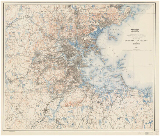
Figure 9.
Map showing the urban layout and the water systems in the metropolitan area of Boston in 1923.
Finally, the case of Bari is discussed in relation to the 20th-century master plans proposed to control urban growth, which did not take into account the surrounding terrain and hydromorphological constraints (Figure 10).
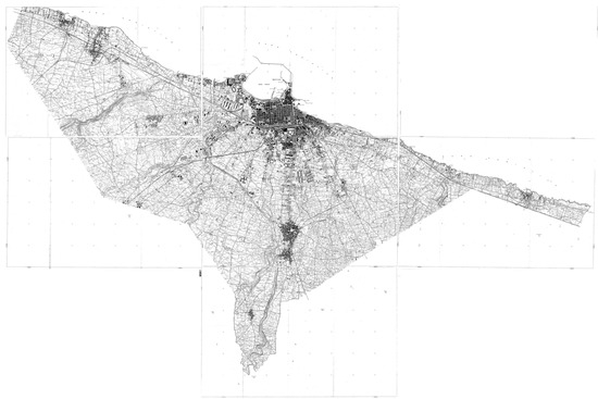
Figure 10.
Maps showing the urban layout and agriculture parcels in the metropolitan area of Bari the 1950s.
In the second section, the case of Bari, which is the most common example of metropolitan urban development among the three mentioned above, is analyzed in more detail, focusing on the area of the southern waterfront. This section provides analysis and examples of possible landscape design for urban parks and public spaces and presents different approaches to reconnecting urban and rural morphologies, peripheries and agricultural or natural areas. To this end, it analyzes the characteristics of urban interstices in this sprawling area and shows how landscape design can solve the need for morphological reconnection and meet the socio-ecological demands of the contemporary city. Finally, it discusses possible paths for urban design based on the formalization of the agrarian and natural interstices to be transformed into the new hubs of the 21st-century city.
The aim of this section is to show that landscape design for the 21st-century city should not aim at completely anthropomorphizing urban development by transforming empty spaces in the background of the built environment, nor at completely naturalizing the city by recreating urban wilderness or enclaves or enclosures opposed to urban life within the built environment. Rather, the centrality of landscape architecture in contemporary urban planning lies in its ability to establish relationships that make it possible to visualize, interpret and invert the urban figure with its background, with the aim of establishing new connections between urban areas, between city and territory; to give order to inhomogeneous areas, fitting them into the torn and discontinuous web of the contemporary city; as well as to solve emerging and urgent hydrogeological and environmental problems.
Therefore, spanning from analysis to design, the second part of this section aims to present a series of possible approaches to the urban landscape reconfiguration of the southern waterfront of Bari, based on the formal reconstruction of linkages between urban, natural and rural areas, aimed at strengthening the relationship between landscape architecture and urban morphology, as well as between territorial analysis, interpretation of local forms and sustainable use and reuse of environmental resources.
3. Results
The analysis of the urban development of the cities of Rome, Boston and Bari, which expanded from the urban scale to the metropolitan dimension, opens up the understanding of how territory influenced and determined urban form.
In the course of their twentieth-century urban development, these cities incorporated agricultural and natural areas into their dimension in very different and peculiar ways, planned and spontaneous, and produced similarly interwoven metropolitan forms.
3.1. The Relationship between the Territorial Layout of the Valleys and the Presence of Historic Villas and Parks, and the Urban Development of Rome
The current conformation of the metropolitan area of Rome is just one of several examples that can clarify the relationship between urban design and territorial structure, where elements of the natural and rural environment have contributed to shaping its urban form (Figure 11).
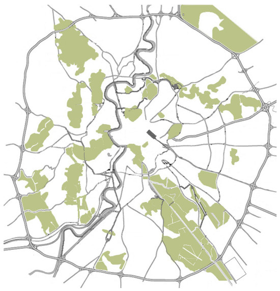
Figure 11.
Map of the urban parks of Rome, within the limits of the Grande Raccordo Anulare.
Today, the city is the largest agricultural municipality in Europe, with 50 thousand hectares of cultivated land, to which must be added the urban green areas of various typologies and functions (parks, historic villas, public and private gardens), which cover 67% of the municipal territory, or 85 out of 129 thousand hectares [46]. In addition to the quantitative data, the qualitative data seem to be significant: the parks and natural reserves that permeate the urban center of Rome include 18 protected areas (including Castel Fusano, the Insugherata, Monte Mario or Marcigliana natural reserves; the Vejo and Del Pineto Park; the Valle dei Casali and the Tenuta dei Massimi) and several parks of historic villas (including Villa Doria Pamphili, Villa Ada and Villa Borghese), which were founded as country estates and later incorporated into the urban fabric [47]. This mixture of values (urban, rural, environmental, cultural) defines an apparently disordered metropolitan landscape, which has been addressed by hydromorphological and heritage constraints, and which is rich in resources and elements to be enhanced, reconnected and reconsidered within a coherent vision of the relationship between urban and territorial form of the hilly area along the river axis.
3.2. The Relationship between Landscape Reconnection of Natural Areas along the River and Boston’s Urban Development
From the late 19th century to the early 20th century, the city of Boston, Massachusetts, experienced significant expansion, growing dramatically from a small town of 25,000 to approximately 93,000 inhabitants, and thus transitioning from a colonial town to an urban metropolis [48]. The metropolitan growth and annexation of the city were based on the development of the park system under the City Beautiful Movement and driven by Frederick Law Olmsted [49].
Initially, the landscape architects Olmsted and Eliot were involved in the restoration of the colonial-era Boston Common, which they transformed into a visible part of the urban environment. But over the next few decades, Olmsted envisioned a citywide system of public parks called the “Emerald Necklace” (Figure 12), a 450-acre chain of parks linked by parkways and waterways through Boston and Brookline that would connect the Common and the Public Garden to Franklin Park. The project began in the 1870s with efforts to reclaim and control the marshy area that became the Back Bay and the Fens. In 1880, Olmsted proposed incorporating the Muddy River, which flowed from Jamaica Pond through the marshes, into the park plan by dredging its flow into a meandering stream that emptied into the Charles River. By the turn of the century, a series of walkways along the river connecting small ponds was completed, and this corridor became the linear park system that remains the backbone of the New Boston urban area.
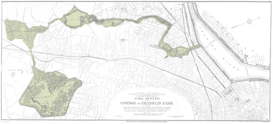
Figure 12.
Boston. Olmsted’s plan for the Emerald Necklace, 1894.
3.3. The Relationship between the Natural Hydromorphology and the Urban Planning of Bari
If we trace the urban transformations of Bari through its twentieth-century regulatory plans, we find a series of master plans designed by the Municipal Technical Office that have largely ignored the natural territorial hydromorphological structure of the so-called “lame”, dry rivers that carry rainwater during heavy rains [50].
Nevertheless, the presence of these watercourses has influenced the growth of the city, marking the footprints of urban parks and gardens (as in the case of the 1938 master plan by Concezio Petrucci or the 1954 master plan by Alberto Calza Bini and Marcello Piacentini), or dictating the limits of the various phases of urban development. In fact, the aerial photogrammetric survey of Bari in 1963 shows that, despite the provisions of the master plans, the urban development was stopped in some areas by the presence of the lame, and therefore large areas of urban agriculture were left in their footsteps, reaching the city center.
This resulted in a radial urban layout along the main territorial routes, interrupted by these agricultural spaces. It is no coincidence, therefore, that in the 1960s, the general plan drawn up by Ludovico Quaroni neglected the development of these areas in the less steep sections, where they were hidden under the urban soil and covered by the suburban sprawl, and that in the following years, the City Council had to draw up a hydrogeological plan in order to protect these areas from further urbanization and the floods and disasters associated with it (Figure 13).
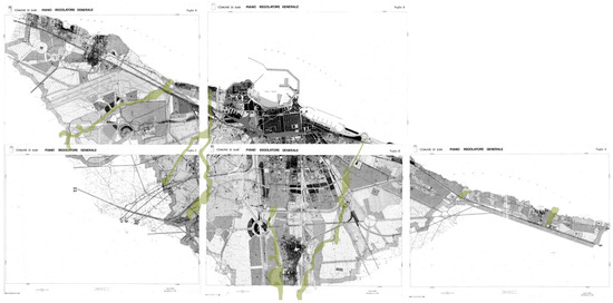
Figure 13.
Superimposition of the “lame” layout on the 1960s general master plan by Ludovico Quaroni.
Recent urban and territorial plans are finally beginning to integrate these complex ecological and environmental structures into metropolitan and regional planning processes.
4. Discussion
Understanding and Designing Urban–Rural Recovery and Regeneration
Today, landscape design actions can decipher and valorize these forms, thus addressing the characteristics of the urban morphology of the 21st century, where the contemporary activities of urban society, including production and leisure, can take place in the interstices and peripheral areas.
The southern coastline of the metropolitan area of Bari seems to be an interesting test bed for the analysis of these conditions because of the coexistence of urban sprawl, scattered urbanization, urban–rural fringes, interstices, urban agriculture and wilderness.
The area is reached by the end sections of two main “lame”, ecological corridors that define an urban extension that faces the shoreline and has the agricultural hinterland at its back. Along these water corridors, fragments of scattered urban fabric are interspersed with pieces of urban agriculture and naturalistic areas (Figure 14 and Figure 15).
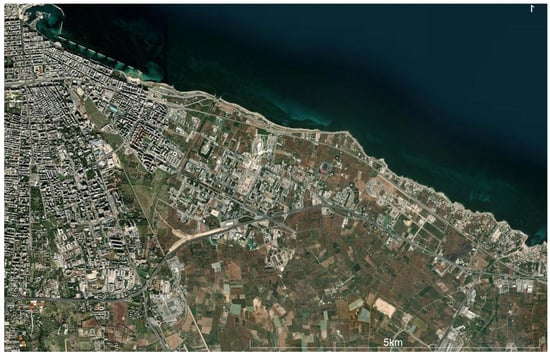
Figure 14.
The southeastern area of the metropolitan city of Bari. Satellite view of the coastline and its hinterland between the two main “lame”.
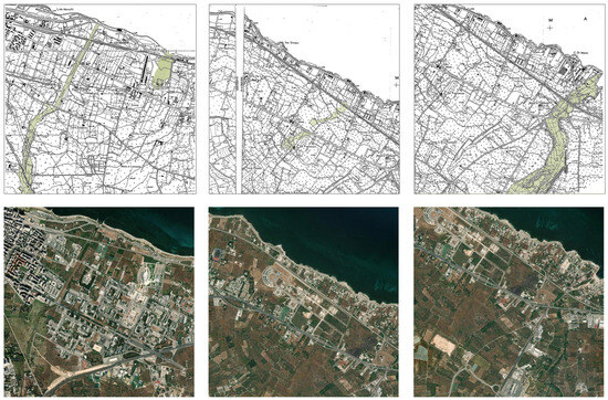
Figure 15.
The southern coastline of the metropolitan area of Bari. Urban and rural fabrics in the cadastral 1960′s map (in green the main “lame”) and the nowadays Satellite view.
The analysis carried out to understand the possible elements of connection between urban and landscape morphology was aimed at interpreting the following characteristics (Figure 16):
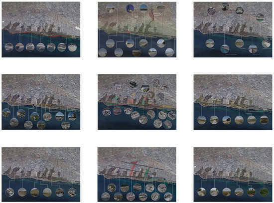
Figure 16.
Analysis of the characteristics and potentials of the area. The study area of the southern waterfront is marked in darker brown. After Landscape Design Studio 2020_2021.
- Characteristics of the coastline. This geomorphologic analysis has led to proposals for several possible uses of the different parts of the area, also for different purposes (leisure, sport, naturalistic).
- Hydrogeological and urban constraints. This analysis was aimed at understanding the different areas for landscape design and urban development.
- Characteristics of public buildings and urban nodes. This analysis was aimed at defining the boundaries of the urban and peri-urban areas.
- Connections between the agricultural and urban hinterland and the coastline. The aim of this analysis was to identify the areas to be improved and strengthened through landscape and urban design.
- Presence of abandoned agricultural areas. The aim of this analysis was to identify areas that have been reclaimed by ruderal species, often endemic, and that today constitute a kind of “third landscape” [44] between urban and agricultural areas.
- Presence of naturalistic areas, protected areas and natural water resources linked to the coastline or to the waterbeds, which are at the basis of the sustainable development of the area. This analysis was aimed at improving and protecting these areas in order to link them to agricultural and natural resources.
- Presence of dispersed urbanization. This analysis was aimed at understanding where the urban morphology lacks coherence and needs to be improved and reinforced.
- Visual axes. This analysis was aimed at understanding where to establish connections between the main nodes of the area located in the hinterland or along the coast.
- Characteristics of the agricultural areas in use. The aim of this analysis was to understand how and where to connect the scattered urban fabric with the peri-urban countryside behind the shoreline.
While the analysis is essential for understanding the characteristics and vocation of the area, the design was aimed at providing new visions for the link areas between urban and rural, agriculture and sea, built and natural environment.
The landscape design proposals for the metropolitan dimension of Bari were therefore aimed at transforming this interface between the countryside and the sea into multifunctional public spaces, where the agricultural landscape is re-knitted with the coastal urban forms, and where the new vision for the public spaces of the peri-urban fabrics is linked to the characteristics of the surrounding territory. In this new consistent approach between sea, urban and agricultural territory, the design actions aimed at defining a complex landscape where green infrastructures and urban agriculture could become the new hubs of urban life, connected to the physical structure of the surrounding territory. Within this framework, the multifunctional value of the urban space is combined with the typical structures of the local agricultural landscape, restoring the physical coherence with the territorial morphology and the connection with the newly emerging environmental urban needs, also in the light of climate change. This approach was therefore aimed at defining landscape forms appropriate to the local climatic, constructive and settlement layout, and at designing new centralities for the civic life of the peripheral and intermediate districts, where agriculture is transformed into multifunctional open spaces. In other words, in new links between urban landscape as the main unifying principle, landscape architecture should aim at transforming the urban spaces and boundaries into multifunctional public spaces, where the agrarian and territorial layout is capable of connecting, in a coherent way, the form of the countryside to the urban context (Figure 17, Figure 18 and Figure 19).
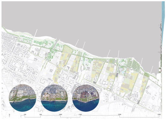
Figure 17.
Landscape design proposal for the morphological re-knitting of the Bari Costa Sud area, based on the mixture of public and agricultural parks. After Landscape Design Studio 2020_2021.
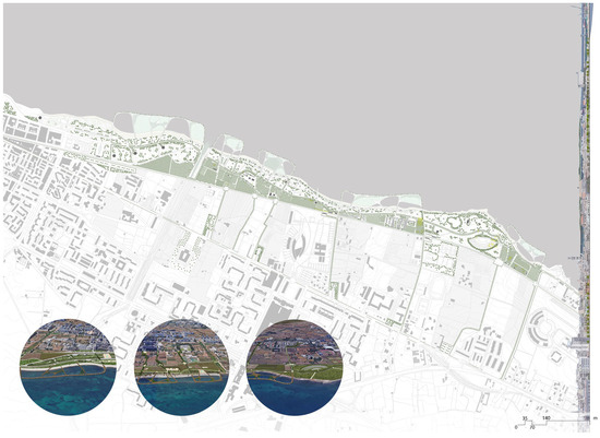
Figure 18.
Landscape design proposal for the morphological re-knitting of the Bari Costa Sud area, based on the connection between the coastline and the agricultural landscape. After Landscape Design Studio 2020_2021.
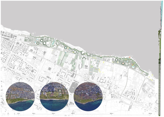
Figure 19.
Landscape design proposal for the morphological recovery of the Bari Costa Sud area, based on the recovery of the dunes, to protect the agricultural and urban areas. After Landscape Design Studio 2020_2021.
Based on the theme of formalizing, the agrarian landscape is reconnected to the peripheral urban forms, and the new vision for peri-urban areas is strongly linked to the surrounding territory identity [51].
5. Conclusions
Throughout the history of cities, gardens and parks have always been part of a sustainable development strategy consistent with the practice of urban design and have played an important role in defining the urban form [29]. In the urban regions that have historically been characterized by a strong continuity between city and countryside, such as the Mediterranean regions, this theme has been one of the cornerstones of their historical urban development.
This paper explores the relationship between territory and urban space, discussing the joint development processes of urban and territorial morphologies, from ancient to modern times. The paper argues that territorial structure is a precursor to urban design, especially in interstitial spaces or unbuilt geographies. Focusing on the role of hydromorphologies in shaping the urban form of Rome, Boston and Bari, it analyzes a marginal area of the metropolitan city of Bari to propose possible landscape morphologies of reconnection for the resulting interstitial areas, which are still considered empty spaces excluded from urban design.
The aim of the paper is to show that the urban gaps and boundaries resulting from the hydrogeological constraints included in the urban sprawl can be transformed into multifunctional public spaces, where the agricultural landscape is reconnected to the peripheral urban forms, and where the new vision for the marginal areas is strongly linked to the characteristics of the surrounding territory. This can be addressed through the medium of landscape architecture. The landscape design proposal for the morphological re-knitting of the Bari Costa Sud area proposed different morphological layouts: based on the mixture of public and agricultural parks (Figure 16); based on the connection between the coastline and the agricultural landscape (Figure 17); or based on the recovery of the dunes to protect the agricultural and urban area (Figure 18).
In the first case, the possibility of giving value to the spaces in between was strengthened; in the second, the possibility of revaluing the form of the coastline was enhanced; and finally, in the third case, the natural form of the dune was transformed into an architectural form, while still using vegetal and landform materials.
Today, in an ecological and urban foresight of urban development, adaptation and transformation, it is particularly necessary to design in response to the ongoing phase of profound climate change, consistent with territorial and environmental conditions.
The challenges that contemporary urban design poses to us must be met by anticipating a landscape design that increasingly moves towards a long-term concept of sustainability; towards projects that are deeply linked to the characteristics, materials and morphology of places, so as to capture local resources and potentials and make them available as a driving force for design. To this end, the analysis phase, the understanding of the territorial layout and the role of the territory in defining the urban morphology, takes on a significant weight, comparable to that of the design.
Funding
This research received no external funding.
Data Availability Statement
Data sharing is not applicable. No new data were created or analyzed in this study. Data sharing does not apply to this article.
Acknowledgments
Landscape design proposals for the morphological recovery of the Bari Costa Sud area were developed during the Landscape Design Studio 2020_2021 at the School of Architecture of the Polytechnic University of Bari (G.A.N.).
Conflicts of Interest
The author declares no conflicts of interest.
References
- Jorgensen, A.; Tylecote, M. Ambivalent landscapes—Wilderness in the urban interstices. Landsc. Res. 2007, 32, 443–462. [Google Scholar] [CrossRef]
- Gallent, N.; Shaw, D. Spatial planning, area action plans and the rural-urban fringe. J. Environ. Plan. Manag. 2007, 50, 617–638. [Google Scholar] [CrossRef]
- Augé, M. Non-Places. Introduction to an Anthropology of Supermodernity; Verso: London, UK; New York, NY, USA, 1995. [Google Scholar]
- De Solá-Morales, I. Territorios; Gustavo Gili: Barcelona, Spain, 2002. [Google Scholar]
- Mariani, M.; Barron, P. Terrain Vague: Interstices at the Edge of the Pale; Routledge: New York, NY, USA, 2013. [Google Scholar]
- La Rosa, D.; Privitera, R. Characterization of non-urbanized areas for land-use planning of agricultural and green infrastructure in urban contexts. Landsc. Urban Plan. 2013, 109, 94–106. [Google Scholar] [CrossRef]
- La Greca, P.; La Rosa, D.; Martinico, F.; Privitera, R. Agricultural and Green infrastructures: The role of non-urbanized areas for eco-sustainable planning in metropolitan region. Environ. Pollut. 2011, 159, 2193–2202. [Google Scholar] [CrossRef] [PubMed]
- Jorgensen, A.; Keenan, R. Urban Wildscapes; Routledge: London, UK, 2012. [Google Scholar]
- Berger, A. Drosscape: Wasting Land Urban America; Princeton Architectural Press: New York, NY, USA, 2007. [Google Scholar]
- Gandy, M. Marginalia: Aesthetics, ecology, and urban wastelands. Ann. Assoc. Am. Geogr. 2013, 103, 1301–1316. [Google Scholar] [CrossRef]
- Brighenti, A.M. Urban Interstices: The Aesthetics and the Politics of the In-Between; Ashgate: Surrey, UK, 2013. [Google Scholar]
- Gandy, M. Urban Constellations; Jovis: Berlin, Germany, 2011. [Google Scholar]
- Sousa Matos, R. Urban Landscape: Interstitial Spaces. Landsc. Rev. 2009, 13, 61–71. [Google Scholar]
- Donadieu, P. Campagnes Urbaines; Ecole Nationale Superieure Du Paysage: Versailles, France, 1998. [Google Scholar]
- UN-Habitat. Urban-Rural Linkages: Guiding Principles Framework for Action to Advance Integrated Territorial Development; United Nations Human Settlements Programme: Nairobi, Kenya, 2019. [Google Scholar]
- Zorzi Mühlmann, U. Progettare il Cambiamento. Stormwater Management; AIAPP: Florence, Italy, 2019. [Google Scholar]
- Muratori, S. Civiltà e Territorio; Centro Studi di Storia Urbanistica: Rome, Italy, 1967. [Google Scholar]
- McHarg, I. Design with Nature; John Wiley & Sons Inc.: New York, NY, USA, 1969. [Google Scholar]
- Gillham, O. The Limitless City. A Primer on the Urban Sprawl Debate; Island Press: Washington, DC, USA, 2002. [Google Scholar]
- Van Leeuwen, E.; Nijkamp, P. The Urban-Rural Nexus: A study on Extended Urbanization and the Hinterland. Stud. Reg. Sci. 2006, 36, 283–303. [Google Scholar] [CrossRef][Green Version]
- Thomas, K.; Littlewood, S. From Green Belts to Green Infrastructure? The Evolution of a New Concept in the Emerging Soft Governance of Spatial Strategies. Plan. Pract. Res. 2010, 25, 203–222. [Google Scholar] [CrossRef]
- Meyer-Cech, K.; Seher, W. Preservation of Farmlands in the Urban Fringe. A critical review of Planning Instruments Implemented. In Land Management: Potential, Problems and Stumbling Blocks; Hepperle, E., Lenk, H., Eds.; European Academy of Land Use and Development: Zürich, Switzerland, 2013. [Google Scholar]
- Silva, C.A. Urban sprawl and interstitial spaces: A conceptual definition for undeveloped areas and their morphological implications in planning. In Proceedings of the International Conference on Changing Cities II: Spatial, Design, Landscape & Socio-Economic Dimensions; Gospodini, A., Ed.; Grafima Publ: Porto Heli, Greece, 2015. [Google Scholar]
- Caniggia, G. Strutture dello Spazio Antropico; Florence: Uniedit, Italy, 1976. [Google Scholar]
- Sica, P. L’Immagine della Città. Da Sparta a Las Vegas; Laterza: Bari, Italy, 1991. [Google Scholar]
- Benevolo, L. Le Origini dell’Urbanistica Moderna; Laterza: Bari, Italy, 1968. [Google Scholar]
- Cuneo, P. Storia dell’Urbanistica. Il Mondo Islamico; Laterza: Bari, Italy, 1986. [Google Scholar]
- Gaube, H. Iranian Cities; New York University Press: New York, NY, USA, 1979. [Google Scholar]
- Neglia, G.A. Tutto è Giardino. Paradigmi di Paesaggi Sostenibili tra Mediterraneo e Medioriente; Aion: Florence, Italy, 2018. [Google Scholar]
- Geddes, P. Cities in Evolution. An Introduction to the Town Planning Movement and to the Study of Civics; Forgotten Books: London, UK, 2012. [Google Scholar]
- Howard, E. Garden Cities of To-Morrow; Swan Sonnenschein & Co.: London, UK, 1902. [Google Scholar]
- Park, R.E.; Burgess, E.W.; McKenzie, R.D. The City; University of Chicago Press: Chicago, IL, USA, 1925. [Google Scholar]
- Hoyt, H. The Structure and Growth of Residential Neighborhoods in American Cities; Federal Housing Administration: Washington, DC, USA, 1939.
- Harris, C.D.; Ullman, E.L. The Nature of Cities. Ann. Am. Acad. Political Soc. Sci. 1945, 242, 7–17. [Google Scholar] [CrossRef]
- Le Corbusier. The City of Tomorrow and Its Planning; Dover Architecture: Mineola, NY, USA, 2013. [Google Scholar]
- Pfeiffer, B.B. (Ed.) The Disappearing City. In Frank Lloyd Wright. Frank Lloyd Wright Collected Writings, Volume 3: 1931–39; Rizzoli International Publications, Inc.: New York, NY, USA, 1993. [Google Scholar]
- Smith, C. The Plan of Chicago: Daniel Burnham and the Remaking of the American City; University of Chicago Press: Chicago, IL, USA, 2006. [Google Scholar]
- Gottmann, J. Megalopolis: The Urbanized Seaboard of the United States; The MIT Press: Cambridge, MA, USA, 1961. [Google Scholar]
- Ingegnoli, V. Ecologia del Paesaggio. In Paesaggi: Una Storia Contemporanea; Giammattei, E., Ed.; Treccani: Rome, Italy, 2019; pp. 295–338. [Google Scholar]
- Romani, V. Il Paesaggio; Franco Angeli: Milan, Italy, 2008. [Google Scholar]
- Waldheim, C. (Ed.) The Landscape Urbanism Reader; Princeton Architectural Press: New York, NY, USA, 2006. [Google Scholar]
- Council of Europe. The European Landscape Convention; Florence Convention: Florence, Italy, 2000. [Google Scholar]
- Young, D.; Wood, P.; Keil, R. In-Between Infrastructure: Urban Connectivity in an Age of Vulnerability; Praxis (e)Press: Toronto, ON, Canada, 2011. [Google Scholar]
- Clément, G. Manifeste du Tiers Paysage; Éditions Sujet/Objet: Paris, France, 2004. [Google Scholar]
- Sereni, E. Storia del Paesaggio Agrario Italiano; Laterza: Bari-Rome, Italy, 1961. [Google Scholar]
- Cavallo, A.; Di Donato, B.; Guadagno, R.; Marino, D. Cities, Agriculture and Changing Landscapes in Urban Milieu: The Case of Rome. Riv. Studi Sulla Sostenibilità 2015, 1, 79–97. [Google Scholar] [CrossRef]
- Insolera, I. Roma Moderna. Un Secolo di Urbanistica Romana 1870–1970; Einaudi: Turin, Italy, 1993. [Google Scholar]
- Penna, A.N.; Wright, C.E. (Eds.) Remaking Boston: An Environmental History of the City and Its Surroundings; University of Pittsburgh Press: Pittsburgh, PA, USA, 2009. [Google Scholar]
- Beveridge, C.E.; Rocheleau, P. Frederick Law Olmsted: Designing the American Landscape; Universe Publishing: New York, NY, USA, 1998. [Google Scholar]
- Storia della Citta: Rivista Internazionale di Storia Urbana e Territoriale Bari Moderna 1790/1990; Electa: Milan, Italy, 1989; Volume 51.
- Neglia, G.A. Giardini Produttivi. Nuovi Modelli per Gli Spazi Pubblici delle Città Mediterranee; AFG: Bari, Italy, 2016. [Google Scholar]


Disclaimer/Publisher’s Note: The statements, opinions and data contained in all publications are solely those of the individual author(s) and contributor(s) and not of MDPI and/or the editor(s). MDPI and/or the editor(s) disclaim responsibility for any injury to people or property resulting from any ideas, methods, instructions or products referred to in the content. |
© 2023 by the author. Licensee MDPI, Basel, Switzerland. This article is an open access article distributed under the terms and conditions of the Creative Commons Attribution (CC BY) license (https://creativecommons.org/licenses/by/4.0/).