

Is Historical Cartography a Useful Tool for Landscape Analysis? A Perspective from Inland Spain (Zorita de los Canes, Guadalajara) from the Middle Ages to the Present

Abstract
1. Introduction
2. Theoretical and Analytical Framework for an Early Middle Ages Landscape
3. Methodology
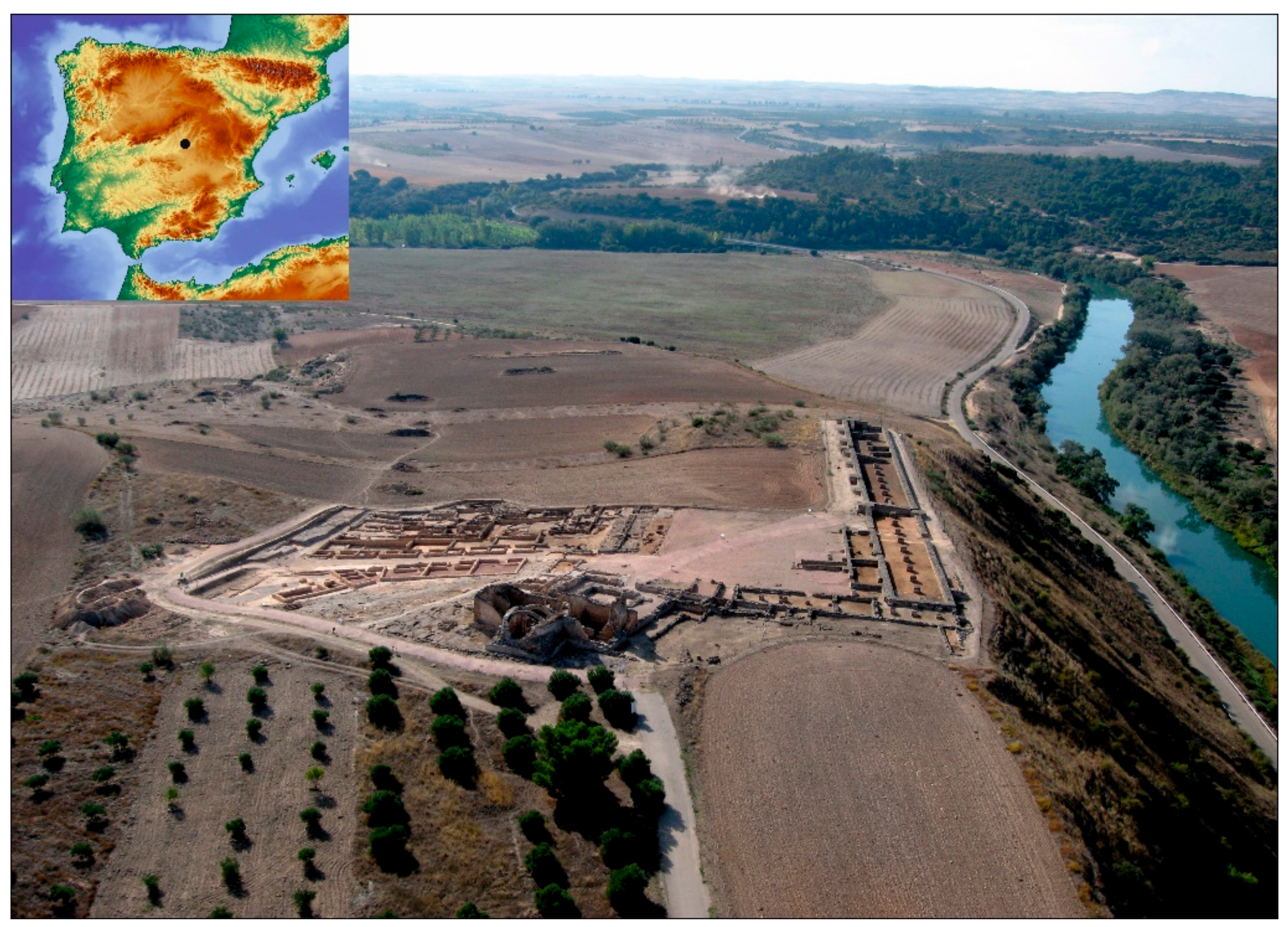
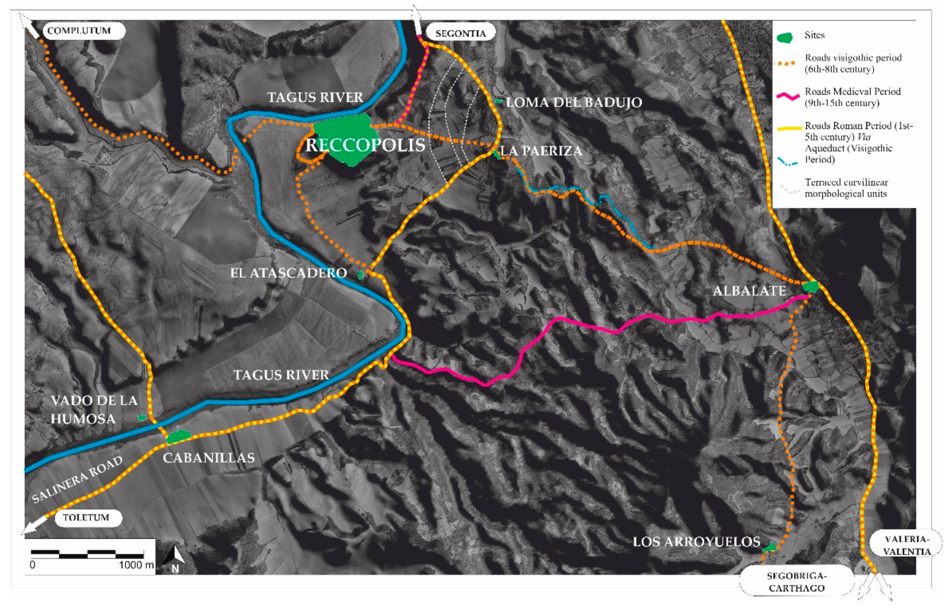
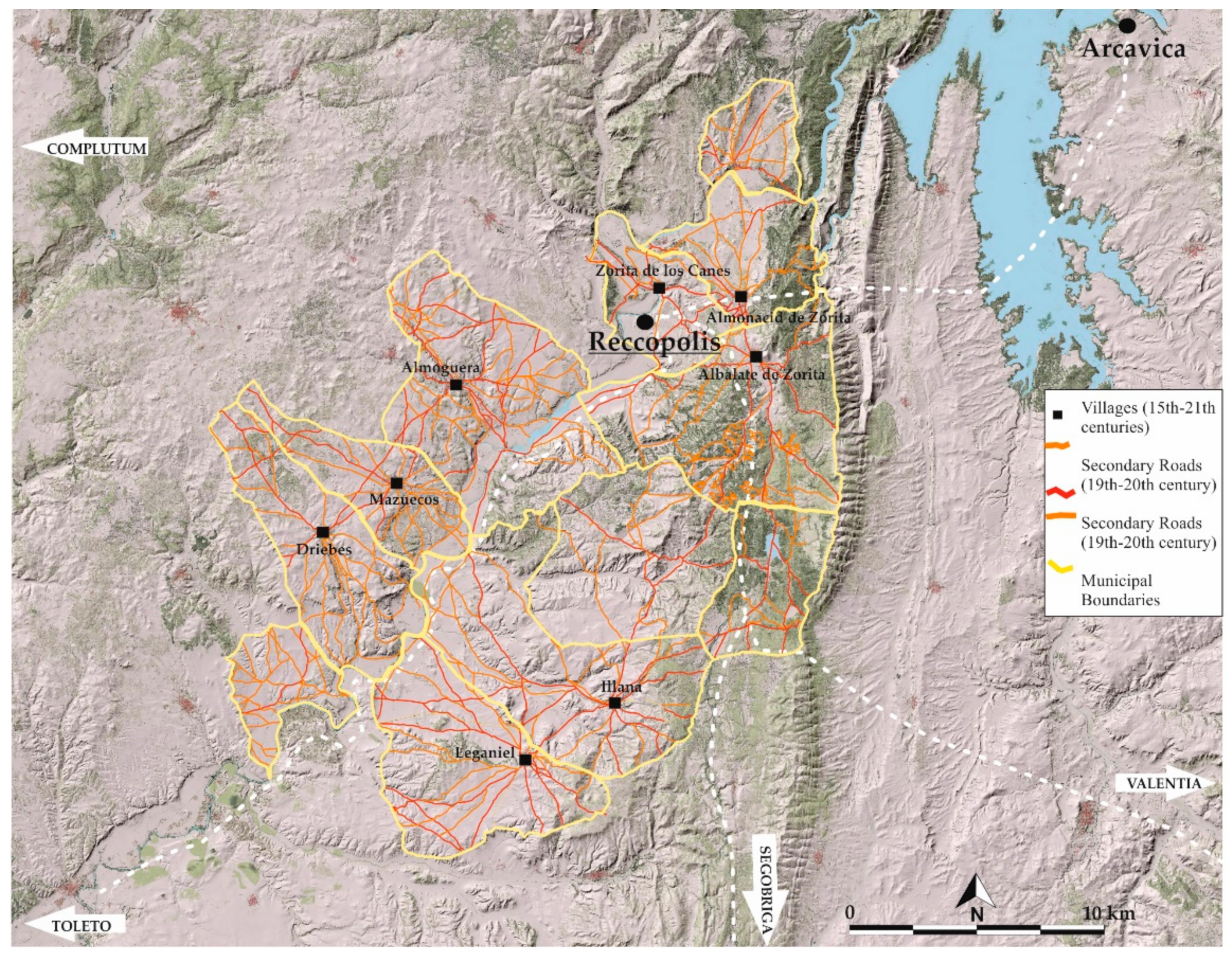
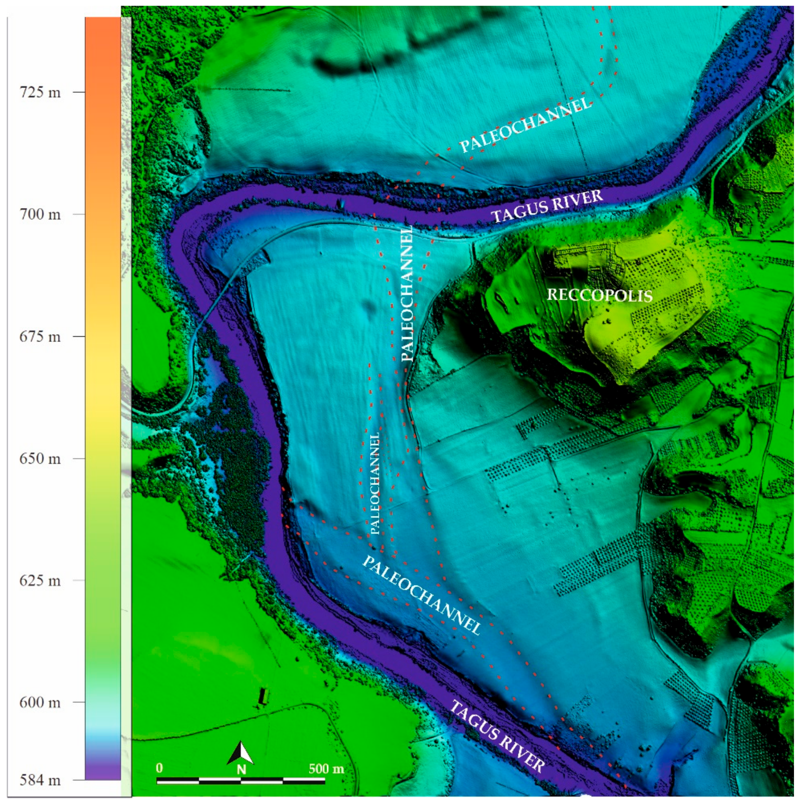
3.1. Study Area
3.2. Sources of Information and Regression Map Analysis
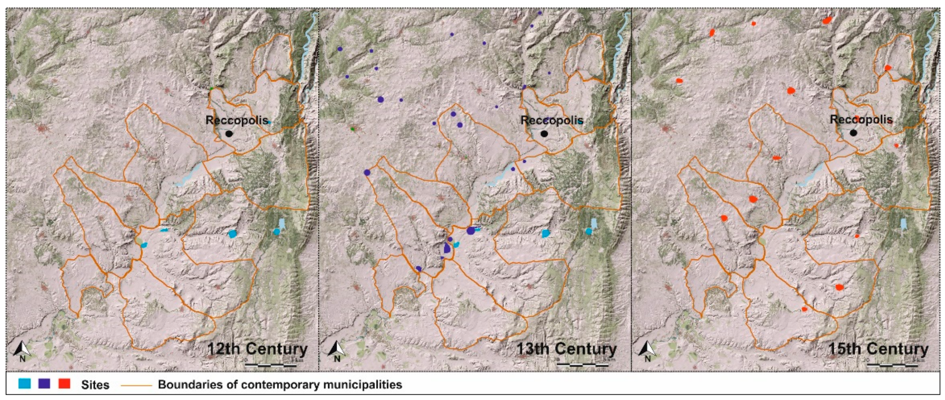
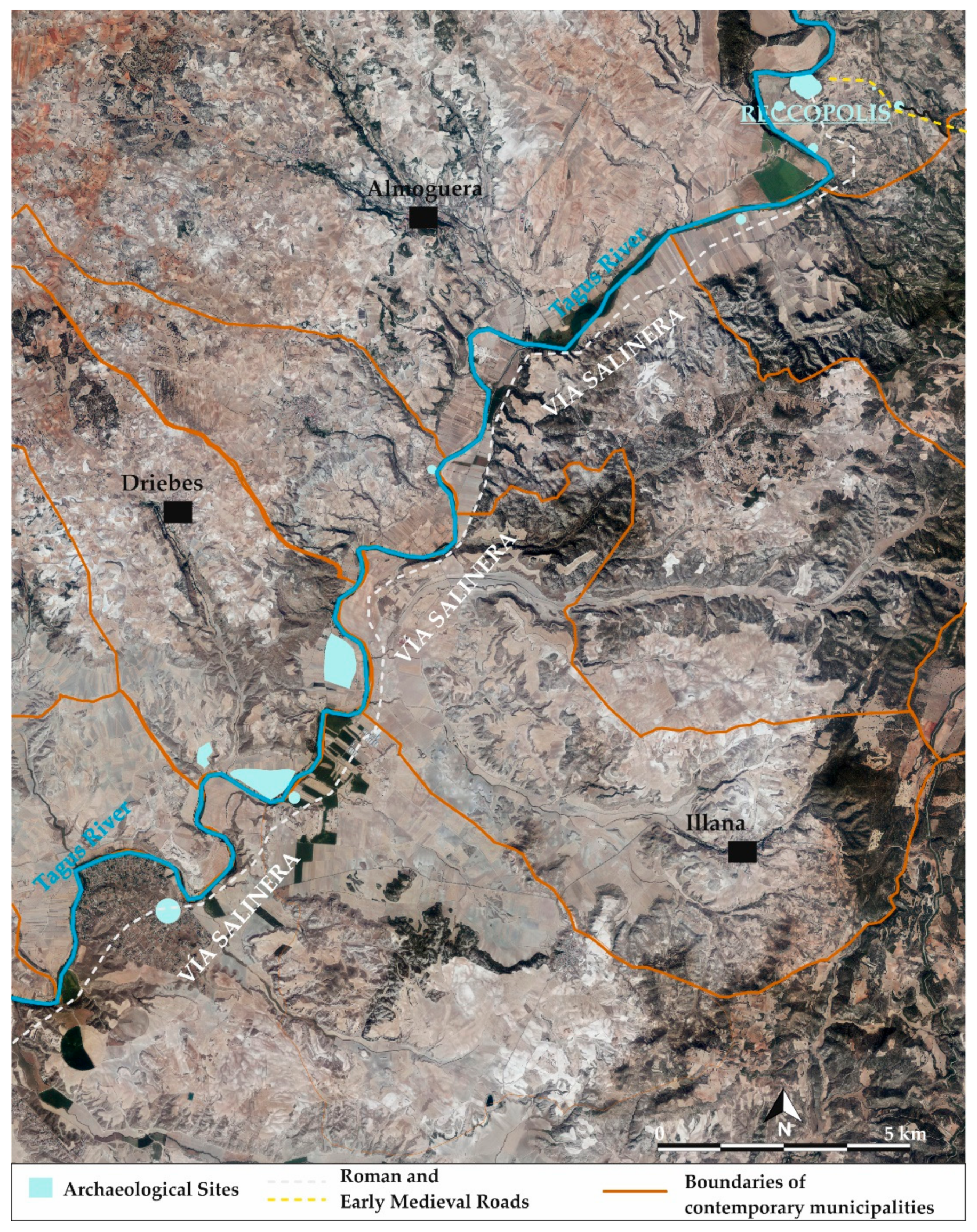
4. Results and Discussion
- Temporal context: Historical maps show how the region was perceived in earlier times. By comparing modern maps or current satellite images with ancient ones, we have detected changes in the landscape, suggesting the presence of archaeological sites and socio-cultural changes.
- Detection of missing features: Some structures and settlements may have disappeared over time due to erosion, abandonment or new urbanisation processes. Historical maps can reveal the locations of features that are no longer visible in today’s landscape, which helps to direct archaeological investigations.
- Identification of patterns and trends: By examining historical maps from different periods, we have been able to identify settlement patterns, areas of cultivation and other relevant data. These patterns have provided valuable information on how societies interacted with the landscape and with each other.
- Planning archaeological research: Historical mapping can help archaeologists to identify areas potentially rich in archaeological remains, allowing them to plan excavations and field surveys more efficiently.
- Cultural contextualisation: Historical maps can also provide information on toponymy, historical boundaries and other cultural aspects that may be essential in understanding the historical evolution of a territory.
5. Conclusions
Author Contributions
Funding
Institutional Review Board Statement
Informed Consent Statement
Data Availability Statement
Acknowledgments
Conflicts of Interest
| 1 | |
| 2 | |
| 3 | The Order of Calatrava was a military and religious order founded in the 12th century in the Kingdom of Castile, with the initial objective of protecting the town of Calatrava, Ciudad Real. In a relatively short time, its immense human and economic resources gave the Order sweeping political and military power, which lasted until the end of the Reconquista. The order owned lands and castles all along the border between Castile and Aragon and exercised feudal lordship over thousands of vassals [33,34]. |
References
- Gillespie, S.D. Archaeological Drawing as Re-Presentations: The Maps of Complex A, La Venta, Mexico. Lat. Am. Antiq. 2011, 22, 3–36. [Google Scholar] [CrossRef]
- Sobala, M. Do historical maps show the maximal anthropopressure in the Carpathians? J. Mt. Sci. 2021, 18, 2184–2200. [Google Scholar] [CrossRef]
- Sánchez-Pinto, I. Historical Mapping vs. Archaeology: Rethinking Fort Sancti Spiritus (1527–1529). Hist. Archaeol. 2023, 57, 220–251. [Google Scholar] [CrossRef]
- Quirós Castillo, J.A. Early medieval landscapes in north-wet Spain: Local power and communities, fifth-centuries. Early Mediev. Eur. 2011, 19, 285–311. [Google Scholar] [CrossRef]
- Sánchez Pardo, J.C. Power and rural landscapes in early medieval Galicia (400–900 AD): Towards a re-incorporation of the archaeology into the historical narrative. Early Mediev. Eur. 2013, 21, 140–168. [Google Scholar] [CrossRef]
- Fernández Mier, M. Peasant Communities and Landscape Change in North-West Iberia. In Polity and Neighbourhood in Early Medieval Europe; Escalona, J., Vésteinsson, O., Stuart Brookes, S., Eds.; Brepols: Turnhout, Belgium, 2019; pp. 57–82. [Google Scholar]
- Diarte-Blasco, P. Late Antique and Early Medieval Hispania: Landscapes without Strategy? Oxbow Books: Oxford, UK, 2018. [Google Scholar]
- Olmo-Enciso, L.; Castro Priego, M.; Diarte Blasco, P. Transformación social y agrosistema en el interior peninsular durante la Alta Edad Media (s. VI-VIII d. C.): Nuevas evidencias desde Recópolis (Zorita de los Canes, Guadalajara). Lucentum 2019, 38, 355–377. [Google Scholar] [CrossRef]
- Olmo-Enciso, L.; Castro-Priego, M.; Ruiz-Zapata, B.; Gil-García, M.J.; Galindo-Pellicena, M.; Checa-Herráiz, J.; Gómez de la Torre-Verdejo, A. The Construction and Dynamics of Early Medieval Landscapes in Central Iberia. In Mediterranean Landscapes in Post Antiquity: New Frontiers and New Perspectives; Gelichi, S., Olmo-Enciso, L., Eds.; Archeopress: Oxford, UK, 2019; pp. 104–128. ISBN 978-1789691900. [Google Scholar]
- Helama, S.; Jones, P.D.; Briffa, K.R. Dark Ages Cold Period: A literature review and directions for future research. Holocene 2017, 27, 1600–1606. [Google Scholar] [CrossRef]
- Gil García, M.J.; Ruiz Zapata, M.B.; Santisteban, J.I.; Mediavilla, R.; Lopez-Parno, E.; Dabrio, C.J. Late holocene environments in Las Tablas de Daimiel (south central Iberian peninsula, Spain). Veg. Hist. Archaeobot. 2007, 16, 241–250. [Google Scholar] [CrossRef]
- Ruiz Zapata, M.B.; Gil García, M.J.; Arenas Esteban, J.; Martín Arroyo, T. El impacto del asentamiento celtibérico de Peña Moñuz (cuenca superior del Tajo) sobre el paisaje vegetal: Análisis polínico. Geogaceta 2014, 55, 83–86. [Google Scholar]
- Moreno, A.; Valero-Garcés, B.; González-Sampériz, P.; Rico, M. Flood response to rainfall variability during the last 2000 years inferred from the Taravilla Lake record (Central Iberian Range, Spain). J. Paleolimnol. 2008, 40, 943–961. [Google Scholar] [CrossRef]
- Moreno, A.; Pérez, A.; Frigola, J.; Nieto-Moreno, V.; Rodrigo-Gámiz, M.; Martrat, B.; González-Sampériz, P.; Morellón, M.; Martín-Puertas, C.; Corella, J.P.; et al. Medieval Climate Anomaly in the Iberian Peninsula reconstructed from marine and lake records. Quat. Sci. Rev. 2012, 43, 16–32. [Google Scholar] [CrossRef]
- Currás, A.; Zamora, L.; Reed, J.M.; García-Soto, E.; Ferrero, S.; Armengol, X.; Mezquita-Joanes, F.; Marqués, M.A.; Riera, S.; Julià, R. Climate change and human impact in central Spain during Roman times: High-Resolution multi-proxy analysis of a tufa lake record (Somolinos, 1280 m asl). Catena 2012, 89, 31–53. [Google Scholar] [CrossRef]
- Chouquer, G. Transmissions et transformations dans les formes parcellaires en France. Esquisse d’un schéma général d’interprétation. In Actes du Colloque “Forêt, Archéologie et Environnement” 14–16 Décembre 2004; Dupouey, J.L., Dambrine, E., Dardignac, C., Georges-Leroy, M., Eds.; l’Office National des Forêts, l’Institut National de la Recherche Agronomique et la Direction Regionale des Affaires Culturelles de Lorraine: Nancy, France, 2007; pp. 21–33. [Google Scholar]
- Watteaux, M. La Dynamique de la Planimétrie Parcellaire et des Réseaux Routiers en Vendée Méridionale. Études Historiographiques et Recherches Archéogéographiques; Université Panthéon-Sorbonne: Paris, France, 2009; p. 571. [Google Scholar]
- Braudel, F. Histoire et sciences sociales: La longue durée. Ann. Hist. Sci. Soc. 1958, 13, 725–753. [Google Scholar] [CrossRef]
- Braudel, F. El Mediterráneo y el Mundo Mediterráneo en la Época de Felipe II, 2nd ed.; Monteforte Toledo, M.; Roces, W.; Simón, V., Translators; Fondo de Cultura Económica: Madrid, Spain, 1976. [Google Scholar]
- Porro, J.M. La defensa y consolidación de las fronteras en el Septentrión novohispano: Geografía y desarrollos cartográficos (1759–1788). Anu. Estud. Am. 2011, 68, 19–50. [Google Scholar] [CrossRef]
- Ballesteros-San José, P. Hermandades en Zorita, Almoguera y sus tierras. España Mediev. 1985, 7, 973–990. [Google Scholar]
- Madoz, P.; Sánchez Zurro, D.; Sánchez Sánchez, I. Diccionario Geográfico-Estadístico-Histórico de España y sus Posesiones de Ultramar; Ámbito: Valladolid, Spain, 1985; ISBN 84-8604-790-0. [Google Scholar]
- Camarero Bullón, C. Madrid y su Provincia en el Catastro de Ensenada. Los Pueblos de Madrid 1750–1759; Ediciones del Umbral: Madrid, Spain, 2001; ISBN 978-8495-457-56-1. [Google Scholar]
- Catalina-García, J. Relaciones Topográficas de los Pueblos de España, Hechas de Orden de Felipe II, Guadalajara; Aache Ediciones: Guadalajara, Spain, 2002; ISBN 8495179792. [Google Scholar]
- Pareja Serrada, A. Diplomática Arriacense. Colección de Algunos Documentos, Publicados unos, Inéditos otros, que Pueden Servir para Planear o Ilustrar una “Historia de Guadalajara y su Provincia”; Taller Tipográfico de la Casa de Expósitos: Guadalajara, Spain, 1921. [Google Scholar]
- Potti Manjavacas, H.; Sevilla Sánchez, C.; Villalón Esquinas, M.; Sánchez Fanjul, J. SignA, el geoportal del IGN de España: Explotando lo mejor de las IDE y los SIG. Rev. Cart. 2017, 95, 111–128. Available online: https://www.revistasipgh.org/index.php/rcar/article/view/278/275 (accessed on 13 June 2023). [CrossRef]
- Palet Martínez, J.M.; Arnau, G.M.; Hèctor, A.O.R.; Alamino, T.P. Els espais altimontans pirenaics orientals a l’Antiguitat: 10 anys d’estudis en arqueologia del paisatge del GIAP-ICAC/The high mountain areas in the Eastern Pyrenees in Antiquity: 10 years of studies in landscape archaeology from GIAP-ICAC. Treb. D’arqueologia 2017, 21, 77–97. [Google Scholar] [CrossRef]
- Vion, É. L’analyse archéologique des réseaux routiers: Une rupture méthodologique, des réponses nouvelles. Paysages Découverts 1989, 1, 67–99. Available online: https://www.formesdufoncier.org/pdfs/vion.pdf (accessed on 26 April 2016).
- Watteaux, M. The Road Network in the Longue Durée: A Reading Key of the History of Territories. Open Archaeol. 2017, 3, 149–174. [Google Scholar] [CrossRef]
- Watteaux, M. Medieval Agrarian Landscapes seen by French School of Archaeogeography. In People and Agrarian Landscapes. Approaches and Methods for an Archaeology of Peasantry in the Western Mediterranean; Quirós Castillo, J.A., Narbarte Hernández, J., Eds.; Archeopress: Oxford, UK, 2022; pp. 15–51. ISBN 978-1803-274-386. [Google Scholar]
- Instituto Nacional de Estadística (INE). Censo de 1787. “Floridablanca”. Tomo II Comunidades Autónomas de la Submeseta sur; I.N.E. Artes Gráficas: Madrid, Spain, 1987; NIPO WEB: 729-16-002-2. [Google Scholar]
- Hernando, A. El mapa en España. Siglos XV–XVIII; Centro Nacional de Información Geográfica: Madrid, Spain, 1995; ISBN 84-7819-067-8. [Google Scholar]
- Ayala Martínez, C. La Orden de Calatrava, problemas de organización territorial y militar (Siglos XII-XIII). Arqueol. Territ. Mediev. 2003, 10, 157–179. [Google Scholar] [CrossRef][Green Version]
- Madrid Medina, A.; Villegas Díaz, L.R. El Nacimiento de la Orden de Calatrava. Primeros Tiempos de Expansión (Siglos XII y XIII); Instituto de Estudios Manchegos: Granada, Spain, 2009; ISBN 978-84-9915-121-2. [Google Scholar]
- González-Martín, J.A.; Vázquez González, A. Guía de los Espacios Naturales de Castilla-La Mancha; Junta de Comunidades de Castilla-La Mancha: Toledo, Spain, 1991; ISBN 84-7788-181-2. [Google Scholar]
- Abascal-Palazón, J.M. Vías de Comunicación Romanas de la Provincia de Guadalajara; Diputación de Guadalajara: Guadalajara, Spain, 1982; ISBN 843-006-3781. [Google Scholar]
- Palomero Plaza, S. Las Vías Romanas En La Provincia De Cuenca; Diputación Provincial de Cuenca: Cuenca, Spain, 1987; ISBN 84-505-6258-9. [Google Scholar]
- Álvarez González, Y.; Palomero Plaza, S. Las vías de comunicación en Madrid desde época romana hasta la caída del reino de Toledo. In Madrid del siglo IX al XI; Real Academia de Bellas Artes de San Fernando: Madrid, Spain, 1990; pp. 41–64. ISBN 84-451-0243-5. [Google Scholar]


| Document Source | Date | Name | Scale of Analysis | Data Spatiality (GIS) | Type of Information |
|---|---|---|---|---|---|
| 1 | 1910–1970 | Mapa Topográfico Nacional (Instituto Geográfico Nacional) | 1:25,000/1:50,000 | Yes | Topography, toponymy, roads, land use, water resources |
| 1 | 1956–1957 | Army Map Service (USA) | 1:32,000 | Yes | Aerial imagery |
| 2 | 1890–1953 | Planimetrías/Altimetrías (Instituto Geográfico Nacional) | 1:25,000/1:50,000 | Yes | Topography, toponymy, roads, water resources |
| 2 | 1893–1953 | Planos de Población (Instituto Geográfico Nacional) | 1:2000/1:5000 | Yes | Toponymy, roads, urban |
| 2 | 1890–1953 | Cuadernos de Campo (Instituto Geográfico Nacional) | 1:2000/1:5000 | Yes | Topography, toponymy, roads, water resources |
| 2 | 1887 | Mapa Militar (Instituto Geográfico Nacional) | 1:200,000 | Yes | Topography, toponymy, roads |
| 2 | 1845–1850 | Diccionario geográfico-estadístico-histórico de España y sus posesiones de Ultramar (Pascual Madoz) | - | No | Toponymy, roads, land use, water resources |
| 3 | 1781 | Castilla La Nueva. Cuenca y Guadalajara. Mapas generales. (Tomás López) | 1:500,000 | Yes | Toponymy, roads |
| 3 | 1749–1759 | Catastro de la Ensenada | - | No | Toponymy, roads, land use, agrarian information |
| 4 | 1691 | Averiguaciones de las antigüedades de Cantabria, enderezadas principalmente a descubrir las de Guipuzcoa, Vizcaya y Alava (Gabriel Henao) | No | Toponymy | |
| 4 | 1577 | Crónica General de España (Ambrosio de Morales) | No | Toponymy | |
| 4 | 1575–1578 | Relaciones topográficas de los pueblos de España, hechas de orden de Felipe II | - | No | Topography, toponymy, land use, agrarian information, production spaces |
| 5 | 1156 | Privilegio de Alfonso VII concedido a los mozárabes que fueron a poblar a Zorita (1156) Información toponímica, viaria, de paisaje y de usos productivos | No | Toponymy, land use, production spaces, roads | |
| 5 | 1132 | Donación de Vállaga y Hueva, hecha por Don Alfonso el Emperador, a favor de Don Galindo, maestre de Santiago (1132). Información toponímica, agraria y de los usos productivos | - | No | Toponymy, land use, agrarian information |
| 6 | c. 1000 | Ajbār mulūk Al-Andalus (Aḥmad al-Rāzi) | - | No | Toponymy |
| 6 | c. 590 | Chronicon (Juan de Biclaro) | No | Toponymy |
Disclaimer/Publisher’s Note: The statements, opinions and data contained in all publications are solely those of the individual author(s) and contributor(s) and not of MDPI and/or the editor(s). MDPI and/or the editor(s) disclaim responsibility for any injury to people or property resulting from any ideas, methods, instructions or products referred to in the content. |
© 2023 by the authors. Licensee MDPI, Basel, Switzerland. This article is an open access article distributed under the terms and conditions of the Creative Commons Attribution (CC BY) license (https://creativecommons.org/licenses/by/4.0/).
Share and Cite
Diarte-Blasco, P.; Castro-Priego, M. Is Historical Cartography a Useful Tool for Landscape Analysis? A Perspective from Inland Spain (Zorita de los Canes, Guadalajara) from the Middle Ages to the Present. Land 2023, 12, 1627. https://doi.org/10.3390/land12081627
Diarte-Blasco P, Castro-Priego M. Is Historical Cartography a Useful Tool for Landscape Analysis? A Perspective from Inland Spain (Zorita de los Canes, Guadalajara) from the Middle Ages to the Present. Land. 2023; 12(8):1627. https://doi.org/10.3390/land12081627
Chicago/Turabian StyleDiarte-Blasco, Pilar, and Manuel Castro-Priego. 2023. "Is Historical Cartography a Useful Tool for Landscape Analysis? A Perspective from Inland Spain (Zorita de los Canes, Guadalajara) from the Middle Ages to the Present" Land 12, no. 8: 1627. https://doi.org/10.3390/land12081627
APA StyleDiarte-Blasco, P., & Castro-Priego, M. (2023). Is Historical Cartography a Useful Tool for Landscape Analysis? A Perspective from Inland Spain (Zorita de los Canes, Guadalajara) from the Middle Ages to the Present. Land, 12(8), 1627. https://doi.org/10.3390/land12081627