


Evaluating the Effectiveness of Land-Use Policies in Preventing the Risk of Coastal Flooding: Coastal Regions of Helsinki and Espoo

Abstract
:1. Introduction
2. Theoretical Background
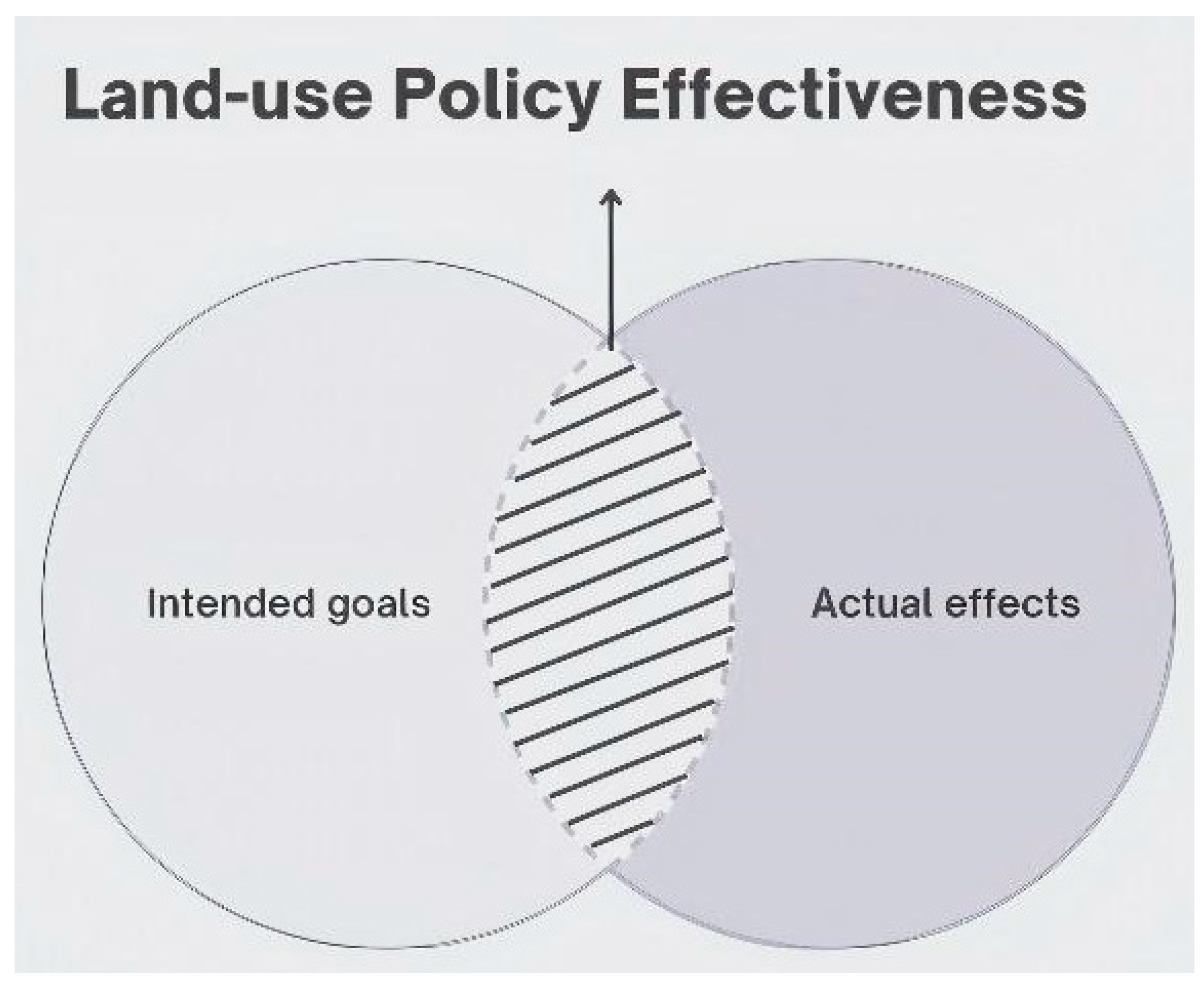
2.1. Restraining Wickedness through Effective Land-Use Policies
2.2. Coastal Flooding
2.3. Coastal Regions of Helsinki and Espoo Municipalities
2.4. National and Municipal Land-Use Policies
3. Materials and Methods
3.1. Materials
3.2. Methods
4. Results
- -
- Environmental protection and prevention of environmental hazards.
- -
- Functionality of communities and good building.
5. Discussion
6. Conclusions
Author Contributions
Funding
Data Availability Statement
Conflicts of Interest
References
- Mäntysalo, R.; Kangasoja, J.K.; Kanninen, V. The paradox of strategic spatial planning: A theoretical outline with a view on Finland. Plan. Theory Pract. 2015, 16, 169–183. [Google Scholar] [CrossRef]
- Rittel, H.W.J.; Webber, M.M. Dilemmas in a general theory of planning. Policy Sci. 1973, 4, 155–169. [Google Scholar] [CrossRef]
- Head, B.W. Wicked Problems in Public Policy. Public Policy 2022, 3, 101–118. [Google Scholar] [CrossRef]
- Duckett, D.; Feliciano, D.; Martin-Ortega, J.; Munoz-Rojas, J. Tackling wicked environmental problems: The discourse and its influence on praxis in Scotland. Landsc. Urban Plan. 2016, 154, 44–56. [Google Scholar] [CrossRef]
- Perry, J. Climate change adaptation in the world’s best places: A wicked problem in need of immediate attention. Landsc. Urban Plan. 2015, 133, 1–11. [Google Scholar] [CrossRef]
- The European Parliament and the Council. Assessment and Management of Flood Risks; Directive 2007/60/EC. Jun. 2007; European Parlament: Brussels, Belgium, 2007. [Google Scholar]
- Yuen, K.W.; Hanh, T.T.; Quynh, V.D.; Switzer, A.D.; Teng, P.; Lee, J.S.H. Interacting effects of land-use change and natural hazards on rice agriculture in the Mekong and Red River deltas in Vietnam. Nat. Hazards Earth Syst. Sci. 2021, 21, 1473–1493. [Google Scholar] [CrossRef]
- Virkki, H.; Kallio, H.; Orenius, O. Sea Level Rise and Flood Risk Assessment in Itä-Uusimaa; GTK: Helsinki, Finland, 2006. [Google Scholar]
- Juuti, P. Näin Aallot Lyövät Helsingin Rantaan Tulevaisuuden Myrskyissä—Vuonna 2005 Tulva Nosti Veden Kauppatorille, Mutta Paljon Pahempaan on Varauduttava. Available online: https://yle.fi/a/3-12121601 (accessed on 13 August 2023).
- Mickwitz, P. A Framework for Evaluating Environmental Policy Instruments. Evaluation 2003, 9, 415–436. [Google Scholar] [CrossRef]
- Scott, E.M. Setting, and evaluating the effectiveness of, environmental policy. Environmetrics 2007, 18, 333–343. [Google Scholar] [CrossRef]
- Taylor, J.J.; Brown, D.G.; Larsen, L. Preserving natural features: A GIS-based evaluation of a local open-space ordinance. Landsc. Urban Plan. 2007, 82, 1–16. [Google Scholar] [CrossRef]
- Xiang, W.-N. Working with wicked problems in socio-ecological systems: Awareness, acceptance, and adaptation. Landsc. Urban Plan. 2013, 110, 1–4. [Google Scholar] [CrossRef]
- Batie, S.S. Wicked Problems and Applied Economics. Am. J. Agric. Econ. 2008, 90, 1176–1191. [Google Scholar] [CrossRef]
- Lazarus, R.J. Super Wicked Problems and Climate Change: Restraining the Present to Liberate the Future. 2009. Available online: https://scholarship.law.georgetown.edu/facpub/159 (accessed on 27 June 2023).
- Enemark, S. A Cadastral Tale; Análisis Geográficos; Instituto Geográfico Agustin Codazzi: Bogota, Columbia, 2006; pp. 147–159. [Google Scholar]
- Howlett, M.; Perl, A.; Ramesh, M. Studying Public Policy; Oxford University Press: Oxford, UK, 2009. [Google Scholar]
- Norton, B.G. The Ways of Wickedness: Analyzing Messiness with Messy Tools. J. Agric. Environ. Ethic. 2011, 25, 447–465. [Google Scholar] [CrossRef]
- Adams-Schoen, S. Taming the Super-Wicked Problem of Waterfront Hazard Mitigation Planning: The Role of Municipal Communication Strategies. In Contemporary Issues in Climate Change Law and Policy: Essays Inspired by the IPCC; SSRN: Rochester, NY, USA, 2016. [Google Scholar]
- Conklin, J. Dialogue Mapping: Building Shared Understanding of Wicked Problems; John Wiley & Sons, Inc.: Hoboken, NJ, USA, 2006. [Google Scholar]
- Head, B.W. Forty years of wicked problems literature: Forging closer links to policy studies. Policy Soc. 2018, 38, 180–197. [Google Scholar] [CrossRef]
- Ruhl, J.B.; Salzman, J. Climate Change, Dead Zones, and Massive Problems in the Administrative State: A Guide for Whittling Away. Calif. Law Rev. 2010, 98, 59–120. [Google Scholar] [CrossRef]
- Cajot, S.; Peter, M.; Bahu, J.-M.; Koch, A.; Maréchal, F. Energy Planning in the Urban Context: Challenges and Perspectives. Energy Procedia 2015, 78, 3366–3371. [Google Scholar] [CrossRef]
- Alford, J.; Head, B.W. Wicked and less wicked problems: A typology and a contingency framework. Policy Soc. 2017, 36, 397–413. [Google Scholar] [CrossRef]
- Kirschke, S.; Kosow, H. Designing policy mixes for emerging wicked problems: The case of pharmaceutical residues in freshwaters. J. Environ. Policy Plan. 2021, 24, 486–497. [Google Scholar] [CrossRef]
- Rogge, K.S.; Reichardt, K. Policy mixes for sustainability transitions: An extended concept and framework for analysis. Res. Policy 2016, 45, 1620–1635. [Google Scholar] [CrossRef]
- Poutanen, M.; Steffen, H. Land Uplift at Kvarken Archipelago/High Coast UNESCO World Heritage area. Geophysica 2015, 50, 49–64. [Google Scholar]
- Pellikka, H.; Johansson, M.M.; Nordman, M.; Ruosteenoja, K. Probabilistic projections and past trends of sea level rise in Finland. Nat. Hazards Earth Syst. Sci. 2023, 23, 1613–1630. [Google Scholar] [CrossRef]
- Intergovernmental Panel on Climate Change. Ocean, Cryosphere and Sea Level Change. In Climate Change 2021—The Physical Science Basis; Cambridge University Press: Cambridge, UK, 2023; pp. 1211–1362. [Google Scholar] [CrossRef]
- Pellikka, H.; Laurila, T.K.; Boman, H.; Karjalainen, A.; Björkqvist, J.-V.; Kahma, K.K. Meteotsunami occurrence in the Gulf of Finland over the past century. Nat. Hazards Earth Syst. Sci. 2020, 20, 2535–2546. [Google Scholar] [CrossRef]
- Pellikka, H. Dark-Blue Horizon: Sea Level Rise and Meteotsunamis on the Finnish Coast; Finnish Meteorological Institute: Helsinki, Finland, 2020. [CrossRef]
- Diez-Sierra, J.; Iturbide, M.; Gutiérrez, J.M.; Fernández, J.; Milovac, J.; Cofiño, A.S.; Cimadevilla, E.; Nikulin, G.; Levavasseur, G.; Kjellström, E.; et al. The Worldwide C3S CORDEX Grand Ensemble: A Major Contribution to Assess Regional Climate Change in the IPCC AR6 Atlas. Bull. Am. Meteorol. Soc. 2022, 103, E2804–E2826. [Google Scholar] [CrossRef]
- Hausfather, Z.; Peters, G.P. Emissions—The business as usual story is misleading. Nature 2020, 577, 618–620. [Google Scholar] [CrossRef] [PubMed]
- Pérez-Molina, E.; Sliuzas, R.; Flacke, J.; Jetten, V. Developing a cellular automata model of urban growth to inform spatial policy for flood mitigation: A case study in Kampala, Uganda. Comput. Environ. Urban Syst. 2017, 65, 53–65. [Google Scholar] [CrossRef]
- Crane, R.; Landis, J. Introduction to the Special Issue. J. Am. Plan. Assoc. 2010, 76, 389–401. [Google Scholar] [CrossRef]
- Alexandra, R. Climate Change Adaptation in Metro Vancouver: Examining the Role of Managed Retreat. Master’s Thesis, University of Waterloo, Waterloo, ON, Canada, 2018. [Google Scholar]
- Biber, E. The Sting of the Long Tail: Climate Change, Backlash and the Problem of Delayed Harm. SSRN Electron. J. 2008, 1292529. [Google Scholar] [CrossRef]
- Nicholls, R.J.; Cazenave, A. Sea-Level Rise and Its Impact on Coastal Zones. Science 2010, 328, 1517–1520. [Google Scholar] [CrossRef]
- Rizzardi, K.W. Washington and Lee Journal of Energy, Climate, and the Environment. Article 4 3-2015 Part of the Energy and Utilities Law Commons, Environmental Law Commons, and the Natural Resources Law Commons. Seas, Receding Ethics? Why Real Estate Professionals Should Seek the Moral High Ground. 2015. Available online: https://scholarlycommons.law.wlu.edu/cgi/viewcontent.cgi?article=1093&context=jece (accessed on 27 June 2023).
- Berkes, F. Implementing ecosystem-based management: Evolution or revolution? Fish Fish. 2011, 13, 465–476. [Google Scholar] [CrossRef]
- Jaana, J.; Kristiina, N.; Paula, T. Climate-Proof Living Environment-Methodologies, Tools and Practical Recommendations for Climate Change Adaptation in the Kymenlaakso and Uusimaa Regions and the Helsinki Metropolitan Area; Gaia: London, UK, 2018. [Google Scholar]
- Zhai, Y.; Yao, Y.; Guan, Q.; Liang, X.; Li, X.; Pan, Y.; Yue, H.; Yuan, Z.; Zhou, J. Simulating urban land use change by integrating a convolutional neural network with vector-based cellular automata. Int. J. Geogr. Inf. Sci. 2020, 34, 1475–1499. [Google Scholar] [CrossRef]
- Uudenmaanliitto. General Flood Map of Coastal Areas of Uusimaa; Finish Government: Helsinki, Finland, 2008.
- Land Use and Building Act (132/1999). Construction in the Waterfront Area. 1999. Available online: https://www.kuntaliitto.fi/opas-rakennusjarjestyksen-laatimiseen/6-opas-ja-mallimaarayksia/67-rakentaminen-ranta-alueella (accessed on 28 July 2023).
- City of Helsinki. Helsinki-Climate-Change-Adaptation-Policies-2019–2025; Publications of the Central Administration, no. 43, 2019; City of Helsinki Administration: Helsinki, Finland, 2019.
- Ministry of Agriculture and Forestry. Finland’s National Climate; Ministry of Agriculture and Forestry: Helsinki, Finland, 2014.
- Granqvist, K.; Humer, A.; Mäntysalo, R. Tensions in city-regional spatial planning: The challenge of interpreting layered institutional rules. Reg. Stud. 2020, 55, 844–856. [Google Scholar] [CrossRef]
- Puustinen, S.; Mäntysalo, R.; Jarenko, K. The Varying Interpretations of Public Interest: Making Sense of Finnish Urban Planners’ Conceptions. Curr. Urban Stud. 2017, 05, 82–96. [Google Scholar] [CrossRef]
- Finish Government. Government Decision on Finland’s National Land Use Guidelines; Finish Government: Helsinki, Finland, 2017.
- Mäntysalo, R.; Kangasoja, J.K.; Kanninen, V. Framing ‘Evidence’ and Scenario Stories in Strategic Spatial Planning; Routledge: Abingdon, UK, 2016; Volume 16, pp. 364–377. [Google Scholar]
- Carter, T.R. Assessing the Adaptive Capacity of the Finnish Environment and Society Under a Changing Climate—Summary for Policy Makers; European Commission: Brussels, Belgium, 2007. [Google Scholar]
- Feranec, J.; Jaffrain, G.; Soukup, T.; Hazeu, G. Determining changes and flows in European landscapes 1990–2000 using CORINE land cover data. Appl. Geogr. 2010, 30, 19–35. [Google Scholar] [CrossRef]
- Robinson, J.B. Futures under glass. Futures 1990, 22, 820–842. [Google Scholar] [CrossRef]
- Wang, Y.; Shen, J.; Yan, W.; Chen, C. Backcasting approach with multi-scenario simulation for assessing effects of land use policy using GeoSOS-FLUS software. MethodsX 2019, 6, 1384–1397. [Google Scholar] [CrossRef] [PubMed]
- Brunner, S.H.; Huber, R.; Grêt-Regamey, A. A backcasting approach for matching regional ecosystem services supply and demand. Environ. Model. Softw. 2016, 75, 439–458. [Google Scholar] [CrossRef]
- Lin, J.; Li, X.; Wen, Y.; He, P. Modeling urban land-use changes using a landscape-driven patch-based cellular automaton (LP-CA). Cities 2023, 132, 103906. [Google Scholar] [CrossRef]
- Zhang, Y.; Kwan, M.-P.; Yang, J. A user-friendly assessment of six commonly used urban growth models. Comput. Environ. Urban Syst. 2023, 104, 102004. [Google Scholar] [CrossRef]
- Mancebo, F. Sustainability Science in the Light of Urban Planning. Chall. Sustain. 2017, 5, 26–34. [Google Scholar] [CrossRef]


| Source Attributes | Causal Attributes | Effect Attributes |
|---|---|---|
| Low number of sources | Limited scale (local and regional) | High level of detectability |
| Low diversity | High temporal limitation | High level of measurability |
| Clustered distribution | Direct and proportional relationship | Proportional distribution over time |
| Large size on average (relative to effects) | Proportional distribution over space | |
| Alignment of incentives | High level of reversibility |
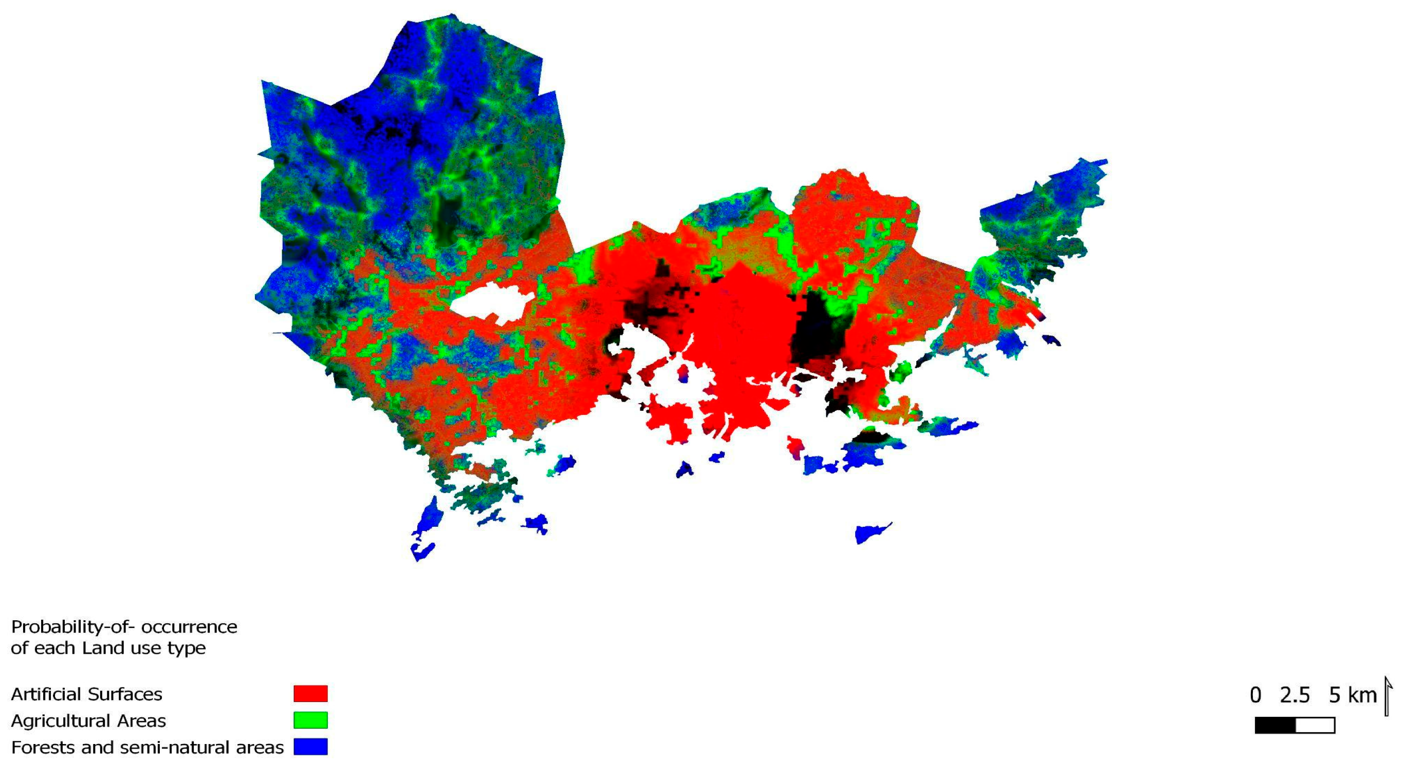
| Land-Use Type at Risk of Flooding | Area in 2000 (km2) | Area in 2018 (km2) | Performance (km2) |
|---|---|---|---|
| Artificial surfaces | 7232 | 6960.4 | Decreased 271.4 |
| Agricultural areas | 3234.2 | 2861.2 | Decreased 373 |
| Forests and semi-natural areas | 11,890.9 | 12,208.8 | Increased 317.9 |
| Wetlands | 5008.9 | 5335.6 | Increased 326.7 |
| Policy Name | Policy Action Mechanism Number | Policy Assignment | |
|---|---|---|---|
| Policy Number | Policy Intensity and Direction | ||
| New residential areas are planned in Östersundom for which land elevation projects are needed to increase the height of land to prevent the risk of flooding (2012). | 01- | D-S-+ | 9 |
| Vegetation measures are planned in the coastal areas of Östersundom to reduce the speed of water runoff and the risk of flooding (2012). | 02- | D-S-+ | 9 |
| New developments include residential areas, business areas, green connections, and recreational areas, including recreational islands in Meri-Rastila-Vuosaari (2016). | 03- | D-S-+ | 9 |
| Residential areas and mixed land-uses are planned in Kruunuvuorenranta coastal areas (2016). | 04- | D-S-+ | 9 |
| Housing development in Pihlajisto with respect to natural and cultural values of Viikki old town bay and its surroundings (2015). | 05- | I-S-+ | 5 |
| Finnoonsatama will be a residential area; however, the recreational and conservation values of the area will be safeguarded (2015). | 06- | I-S-+ | 5 |
| Espoo’s ecological network (EVN) is developed throughout almost all coastal areas to support biodiversity and sustainable use of cultural environments, ecological connectivity, and recreational networks (2008–2018). | 07- | D-W-+ | 5 |
| Developing a green network along the coastlines and naturally valuable areas, an environmental conservation plan, and supporting recreational uses for the city of Helsinki (2016). | 08- | D-W-+ | 5 |
| According to National land-use guidelines, municipalities must be prepaid for extreme weather events and new constructions must be located outside flood risk zone areas or otherwise ensure flood risk management (2008–2017). | 09- | I-S-− | −5 |
| Mapping flood-prone areas started in 2007 and giving instructions for flood preparation started by The European Parliament and The Councils on 23 October 2007. | 10- | D-S-+ | 9 |
| Construction in the shore zones is allowed only according to detailed local plans or a legally binding local master plan. This provision does not apply to (Land-use and Building Act, 2003):building required by agriculture and forestry or fishery | 11- | D-S-+ | 9 |
| building to serve the needs of national defense or frontier control; | 12- | D-S-+ | 9 |
| building required by navigation; | 13- | D-S-+ | 9 |
| building of an outbuilding within the curtilage of an existing residential building; | 14- | D-S-+ | 9 |
| repair of or limited extension of an existing residential building. | 15- | D-S-+ | 9 |
| Flood risks must be considered during planning and construction to ensure that new building developments are not located where they may be damaged by floods (Land-use and Building Act, 2003). | 16- | D-S-+ | 9 |
| Developments along the shores of the Baltic Sea should be located higher than the levels flood waters can be expected to reach once every 200 years on average, plus at least 30 cm to account for wave heights. This means the lowest recommended heights for the bases of buildings would be N60 + 2.60 m in Helsinki (2008). | 17- | D-S-+ | 9 |
| Land-Use (from) | Land-Use (to) | |||
|---|---|---|---|---|
| Artificial Surfaces | Agricultural Areas | Forests and Semi-Natural Areas | Wetlands | |
| Artificial Surfaces | 1 | 0.1 | 0.22 | 0.26 |
| Agricultural areas | 0.9 | 1 | 0.32 | 0.4 |
| Forests and semi-natural areas | 0.99 | 0.16 | 1 | 0 |
| Wetlands | 0.2 | 0.21 | 0.22 | 1 |
| Desirable Land-Use Conversion | Policy Numbers | Policy Names |
|---|---|---|
| Artificial Surfaces Agricultural Areas | 11 | (02)-Vegetation measures are planned in the coastal areas of Östersundom to reduce the speed of water runoff and the risk of flooding (2012) (03)-New developments include residential areas, business areas, green connections, and recreational areas, including recreational islands in Meri-Rastila and Rastila-Vuosaari. (2016) (05)-Housing development in Pihlajisto with respect to natural and cultural values of Viikki old town bay and its surrounding (2015) (07)-Espoo’s ecological network (EVN) is developed throughout almost all coastal areas to support biodiversity and sustainable use of cultural environments, ecological connectivity, and recreational networks. (2008–2018) (08)- Developing a green network along the coastlines and naturally valuable areas, an environmental conservation plan, and supporting recreational uses for the city of Helsinki (2016) (09)-According to National land-use guidelines, municipalities must be prepaid for extreme weather events and new constructions must be located outside flood risk zone areas or otherwise ensure flood risk management (2008–2017) (10)-Mapping flood-prone areas started in 2007 and giving instructions for flood preparation started by The European Parliament and The Councils on 23 October 2007. (11)-Construction in the shore zones is allowed only according to local detailed plans or a legally binding local master plan. This provision does not apply to the building required by agriculture and forestry or fishery. |
| Artificial Surfaces Forests and semi-natural Areas | 07, 08, 11 | |
| Artificial Surfaces Wetlands | 02, 07, 08, 09, 10 | |
| Agricultural Areas Forests and semi-natural Areas | 02, 07, 08, 11 | |
| Agricultural Areas Wetlands | 02, 03, 05,07, 08, 09, 10 |
Disclaimer/Publisher’s Note: The statements, opinions and data contained in all publications are solely those of the individual author(s) and contributor(s) and not of MDPI and/or the editor(s). MDPI and/or the editor(s) disclaim responsibility for any injury to people or property resulting from any ideas, methods, instructions or products referred to in the content. |
© 2023 by the authors. Licensee MDPI, Basel, Switzerland. This article is an open access article distributed under the terms and conditions of the Creative Commons Attribution (CC BY) license (https://creativecommons.org/licenses/by/4.0/).
Share and Cite
Amani Fard, F.; Riekkinen, K.; Pellikka, H. Evaluating the Effectiveness of Land-Use Policies in Preventing the Risk of Coastal Flooding: Coastal Regions of Helsinki and Espoo. Land 2023, 12, 1631. https://doi.org/10.3390/land12081631
Amani Fard F, Riekkinen K, Pellikka H. Evaluating the Effectiveness of Land-Use Policies in Preventing the Risk of Coastal Flooding: Coastal Regions of Helsinki and Espoo. Land. 2023; 12(8):1631. https://doi.org/10.3390/land12081631
Chicago/Turabian StyleAmani Fard, Faegheh, Kirsikka Riekkinen, and Havu Pellikka. 2023. "Evaluating the Effectiveness of Land-Use Policies in Preventing the Risk of Coastal Flooding: Coastal Regions of Helsinki and Espoo" Land 12, no. 8: 1631. https://doi.org/10.3390/land12081631
APA StyleAmani Fard, F., Riekkinen, K., & Pellikka, H. (2023). Evaluating the Effectiveness of Land-Use Policies in Preventing the Risk of Coastal Flooding: Coastal Regions of Helsinki and Espoo. Land, 12(8), 1631. https://doi.org/10.3390/land12081631