Article

A Decision-Support Tool to Augment Global Mountain Protection and Conservation, including a Case Study from Western Himalaya

1
IUCN–WCPA Mountains Specialist Group, Bright, VIC 3741, Australia
2
School of Life Sciences, University of KwaZulu-Natal, Scottsville 3209, South Africa
3
Scientific Services, Ezemvelo KZN Wildlife, Cascades 3202, South Africa
4
Northern Rocky Mountain Science Centre, U.S. Geological Survey, Bozeman, MT 59715, USA
5
Department of Ecology, Montana State University, Bozeman, MT 59715, USA
6
School of Geography and the Environment, University of Oxford, Oxford OX1 3QY, UK
7
Institute of Asian Research, University of British Columbia, Vancouver, BC V6T 1Z2, Canada
8
Climate Research and Development Program, U.S. Geological Survey, Reston, VA 20192, USA
9
School of Earth and Environment, University of Canterbury, Christchurch 8041, New Zealand
10
School of Biological Sciences, University of Canterbury, Christchurch 8041, New Zealand
11
Land Change Science Program, U.S. Geological Survey, Reston, VA 20192, USA
*
Author to whom correspondence should be addressed.
Land 2023, 12(7), 1323; https://doi.org/10.3390/land12071323
Submission received: 31 May 2023 / Revised: 21 June 2023 / Accepted: 27 June 2023 / Published: 30 June 2023
(This article belongs to the Special Issue Perspectives on Mountain Conservation)

Abstract

:
Mountains are remarkable storehouses of global biodiversity that provide a broad range of ecosystem services underpinning billions of livelihoods. The world’s network of protected areas includes many iconic mountain landscapes. However, only ca. 19% of mountain areas globally are protected (excluding Antarctica); many mountain areas are inadequately (<30% of their total terrestrial area) or completely unprotected. To support the UN Convention on Biological Diversity’s Global Biodiversity Framework goal of protecting at least 30% of the world’s lands by 2030, we have developed a strategic decision-support tool for identifying and prioritizing which candidate mountain areas most urgently require protection. To test its efficacy, we applied the tool to the Western Himalaya Case Study Area (WHCSA). The six-step algorithm harnesses multiple datasets including mountain Key Biodiversity Areas (KBAs), World Terrestrial Ecosystems, Biodiversity Hotspots, and Red List species and ecosystems. It also makes use of other key attributes including opportunities for disaster risk reduction, climate change adaptation, developing mountain tourism, maintaining elevational gradients and natural ecological corridors, and conserving flagship species. This method resulted in nine categories of potential action—four categories for follow-up action (ranked by order of importance and priority), and five categories requiring no further immediate action (either because countries are inadequately equipped to respond to protection deficits or because their KBAs are deemed adequately protected). An area-based analysis of the WHCSA identified 33 mountain KBAs regarded as inadequately protected, which included 29 inadequately protected World Mountain Ecosystems. All 33 inadequately protected KBAs in the WHCSA are Category A1: first-priority mountain KBAs (located in the Himalaya Biodiversity Hotspot in developing countries), requiring the most urgent attention for protection and conservation. Priorities for action can be fine-filtered by regional teams with sufficient local knowledge and country-specific values to finalize lists of priority mountain areas for protection. This rapid assessment tool ensures a repeatable, unbiased, and scientifically credible method for allocating resources and priorities to safeguard the world’s most biodiverse mountain areas facing myriad threats in the Anthropocene.

1. Introduction

Mountains support a quarter of the world’s terrestrial biodiversity and account for nearly half of the world’s biodiversity hotspots [1]. Despite covering ca. 22–25% of the world’s continental land surface, mountains are home to more than 85% of the world’s species of amphibians, birds, and mammals [2]. Mountains are recognized as regionally and globally important centres of biodiversity [3] that act as cradles, barriers, and bridges for species [4], contributing disproportionately to the terrestrial biodiversity of Earth. This is especially true in the tropics, where they host extraordinary species richness [2]. Given the sharp gradients of climate and topography over relatively short geographic distances, mountains exhibit high levels of endemism and beta diversity at genetic, species, and ecosystem scales of biological organization [4,5].
Mountains not only harbour critically important biodiversity: they also constitute the headwaters of all major rivers and thus are aptly named “water towers,” supplying at least half of the human population’s freshwater needs for domestic use, irrigation, and hydropower (green energy) [6]. Mountains are rich in natural resources—providing raw materials that support people’s livelihoods and underpin the economies of communities and nations [6]. Mountains are also centres of cultural and ethnic diversity, crucial for the survival and sustainability of many human societies, while simultaneously holding significant recreational, aesthetic, and spiritual values [7,8]. Healthy, resilient mountain ecosystems equally buffer natural hazards, mitigate greenhouse-gas emissions via carbon sequestration, and they can serve as early-warning systems of global change [9,10]. More directly, mountains play a major role in determining and regulating global and regional climates [4,11]. It is not surprising, therefore, that mountains provide the most diverse and highest number of ecosystem services, compared to other physiographic land features and systems [5,12,13].
However, like many other biomes and regions, mountains are experiencing acute impacts associated with climate and global change. Climate change is influencing mountains at a faster rate than other terrestrial habitats globally, especially in areas near the 0 °C isotherm [14,15]. The potential medium- to long-term impacts of climate change in mountains are predicted to include considerable and unprecedented changes to ecosystems, which are likely to be further altered by various anthropogenic interventions [5]. With ongoing global changes in climate and land use, the role of mountains as refugia for biodiversity may become compromised [2]. Despite providing life-essential goods and services, mountain ecosystems, particularly alpine grasslands, remain poorly studied and are amongst the most imperilled of the world’s ecosystems [16]. Outside Antarctica, 17–19% of mountain areas are protected globally [17,18]. Although the most strongly protected terrestrial areas occur disproportionately in mountains at regional to global scales [19,20], significant mountain areas are regarded as inadequately protected [21,22]. Nearly 40% of the world’s mountain ranges do not contain any protected areas [23]. This merits further investigation, as mountains are considered vulnerable places due to the expansion of human activities and resulting economic development, land-use change, and the effects of climate change [24]. Biodiversity in mountains is particularly at risk, as many montane species are adapted to narrow microhabitats, sometimes making them less able to adjust to climate change [25]. Climate change responses particular to mountains include shifts in species’ distributions through upslope retractions, “elevators to extirpation,” altered use of aspects, phenological shifts, and differential use of microrefugia [26,27,28]; such changes may have broad-ranging consequences [29]. Many of the world’s mountains lack elevational corridors to conserve biodiversity. Securing mountain protected areas to better represent and connect elevational gradients may safeguard mountain biodiversity, enhance ecological representation, and facilitate species migration and range shifts [23,30]; efficacy can be further complemented by considering conservation at broader spatial scales [31]. These measures will also safeguard mountain biomes such as forest, shrubland, grassland, sparse and bare cover, and areas with snow and ice; of which the grassland biome is most poorly protected [17] (Figure 1).
These dynamic aspects of mountains and their limited and variable levels of protection warrant further measures to identify, expand, and secure new mountain protected areas in ways that are equitable and fair to local communities. Global change threats (including climate change) necessitate adequate conservation measures that build ecological resilience in mountains [1]. Mountains, however, are not only biophysical entities; they are integrated and often complex socioecological systems [32]. Therefore, establishing more protected and conserved areas in mountains may be vital for ensuring the sustainable use of mountain natural resources in partnership with local communities and could better safeguard the most biodiverse mountains on the planet. This may be achieved through both top-down and bottom-up interventions. We focused on the development of a rapid, top-down strategic approach as one means of addressing the under-representation of protected area coverage in mountain areas. Therefore, our overall aim was to develop a scientifically credible decision-support tool for the identification of inadequately protected mountain areas (<30% of total terrestrial area) and prioritize their importance for protection and conservation. More specifically, our strategic, evidence-based prioritization tool for identifying and proposing sites as potential new protected areas in mountain regions of the world involves the following three core objectives: (1) identifying which mountain areas are currently under-protected and poorly conserved; (2) developing a structured decision-support tool to prioritize which mountain areas require the most urgent protection and conservation and apply it to the Western Himalaya as a case study to test its efficacy; and (3) creating an enabling environment whereby governments, the International Union for Conservation of Nature (IUCN) World Commission on Protected Areas (WCPA), NGOs, and mountain communities can pursue further actions that will assist in the conservation of the highest-priority mountain areas.
This approach should simultaneously (1) reinforce an understanding and appreciation of the critical natural and cultural values of mountain ecosystems; (2) help mitigate the threats to their integrity and ecological functions; and (3) advocate the importance of protecting and conserving representative mountain ecosystems through the most efficient, fair, and equitable ways possible.

2. Materials and Methods

We developed an iterative decision-support tool or “decision tree” (an algorithm with spatially explicit applications) that follows six steps to identify which mountain areas should be secured as protected or conserved areas in global priority regions. Because spatial conservation planning is complex and involves many interrelated factors, our decision-support tool is intended for rapid and strategic application at regional to global scales, with the aim to identify area-based priorities for new mountain protected and conserved areas. We applied this method to the Western Himalaya Case Study Area to identify priority areas for mountain conservation in the region. Our approach hinged upon the following key definitions, datasets, frameworks, and principles:

2.1. Nature-Based Solutions: A Framework for Protected and Conserved Areas

The “nature-based solutions” framework emerged from the Ecosystem Approach, which underpins the UN Convention on Biological Diversity (CBD) and considers biodiversity conservation and human well-being to be dependent on functioning and resilient natural ecosystems [33]. The Ecosystem Approach is a strategy for the integrated management of land, water, and living resources that promotes their conservation and sustainable use, with benefits shared equitably amongst all stakeholders and rights holders [33,34].
“Nature-based solutions” is an umbrella concept for ecosystem-related approaches employed to address societal challenges through the protection, sustainable management, and restoration of ecosystems [35]. These approaches have their roots in the relationship between biodiversity and human well-being [36]. The IUCN has recently published a Global Standard for nature-based solutions [37].
“Protection” may include area-based conservation approaches such as securing and managing protected areas [35] to complement species-specific conservation efforts. These are a cornerstone of global conservation efforts to stem biodiversity loss and focus on protecting important ecosystems and habitats [38]. They include a wide diversity of approaches, geographical scales, and interactions between nature and people.
We follow the IUCN definitions of protected areas, protected area management categories, and governance types [39]. We also subscribe to the expansion of area-based protection to include “protected and conserved areas” (Figure 2). Conserved areas are areas that effectively achieve conservation in situ [40]. They include well-managed protected areas, areas under “other effective area-based conservation measures” (OECMs), “Territories of Life” (also known as “Indigenous Peoples’ and Local Communities Conserved Areas and Territories” (ICCAs) [40,41,42,43,44], as well as unmanaged and ungoverned areas [44]. “Other” conserved areas are those areas and territories that, regardless of formal recognition or dedication and at times regardless of explicit or conscious management practices, are de facto conserved and/or are showing improved conservation measures likely to be maintained long term [45]. Despite the crucial role of “other” conserved areas, their extent is relatively poorly known but monitoring is improving [41,42,43]. Due to historical data collection methods and reporting obligations, the UN Environment Programme World Conservation Monitoring Centre (UNEP–WCMC) has maintained the World Database of Protected Areas (WDPA). This database is primarily based on protected area data reported by governments, and, as a requirement, all sites included in the database meet the IUCN or CBD definition of a protected area [46], together with OECMs and Territories of Life [44] (Figure 2).

2.2. The Convention on Biological Diversity and the Kunming–Montreal Global Biodiversity Framework

The Kunming–Montreal Global Biodiversity Framework (GBF) was agreed to at the 15th meeting of the Conference of Parties (COP 15) to the CBD [47]. The GBF includes concrete measures to halt and reverse nature loss through 23 target objectives. Target 3 states that by 2030, at least 30% of terrestrial, inland water, and coastal and marine areas, especially areas of particular importance for biodiversity and ecosystem functions and services, are effectively conserved and managed through ecologically representative, well connected, and equitably governed systems of protected areas, OECMs, and Territories of Life [47].
This target replaces the previous GBF Aichi Target 11, adopted in 2010, which aimed to have at least 17% of terrestrial and inland water, and 10% of marine areas, protected by 2020. Although these thresholds were not met by 2020, the March 2023 Protected Planet Report indicates that 17.08% of terrestrial areas and 8.26% of marine areas now are protected [48].

2.3. Key Biodiversity Areas (KBAs) and Mountain KBAs

We used multiple input datasets, but principally selected Key Biodiversity Areas (KBAs) as a starting point for numerous reasons. KBAs are sites contributing significantly to the global persistence of biodiversity, in terrestrial, freshwater, and marine ecosystems [49]. KBAs are the most comprehensive dataset on areas of global importance for biodiversity. Protected area coverage of KBAs is used by the CBD as one of the measures to track progress toward Aichi Target 11 (now CBD Target 3) and is also a recognized indicator for the UN Sustainable Development Goals [49]. Of >15,000 terrestrial KBAs identified to date, ca. 40% occur in mountains [50]. As indicators of geographic priorities for species-level conservation efforts, they demonstrate high conservation importance. Of the 6109 KBAs located in mountains, only 996 (16.3%) are entirely covered by protected areas, while 2467 (40.4%) have no protection, leaving 2646 (43.3%) only partially protected [51,52].
For KBAs to have the highest likelihood of long-term provision of ecosystem services and long-term conservation of species, it is important to ensure that KBAs achieve better protection within protected areas and OECMs [46]. KBAs can support the strategic expansion of protected area networks and assist governments and civil society in working toward achieving new biodiversity targets for protected and conserved areas. KBA criteria incorporate threatened biodiversity, geographically restricted biodiversity, ecological integrity, biological processes, and irreplaceability assessed through quantitative analyses [49].
Availability of mountain KBA data is a key strategic opportunity to support and facilitate advancement in the protection of mountains and their contribution to conserving global biodiversity and supporting societal well-being. Thus, the spatial extent of protection of mountain KBAs is the main factor used in this assessment framework to initially identify inadequately protected mountain areas for further assessment. Given the large number of partially or completely unprotected KBA sites, this framework will help to provide a pragmatic focus by applying clear logic with explicit, transparent criteria to prioritize areas for potential action on a repeatable basis.

2.4. Biodiversity Hotspots

The concept of biodiversity hotspots was initially proposed by Conservation International [53]. To qualify as a global biodiversity hotspot, a region must meet two strict criteria: it must host at least 1500 vascular endemic plant species, and its original extent must have been reduced by 70% or more (leaving less than 30% of its original area remaining). A hotspot is thus both threatened and irreplaceable [53]. Around the world, 36 areas qualify as biodiversity hotspots [54]. Although only representing ca. 2.4% of Earth’s land surface, these contain >50% of the world’s endemic plant species and ca. 43% of the world’s endemic bird, mammal, reptile, and amphibian species. About half of the world’s biodiversity hotspots occur in mountain regions. Examples of key mountain areas that are recognized as biodiversity hotspots include the mountains of Central Asia, the Himalaya, Tropical Andes, Caucasus, Eastern Afromontane, and the mountains of southwest China. Biodiversity hotspot locations and their associated values appear on the Critical Ecosystem Partnership Fund website [54].

2.5. IUCN Red Lists for Species and Ecosystems

The IUCN Red List of Threatened Species is the world’s most comprehensive source of information on the global conservation status of animal, fungi, and plant species. By evaluating the extinction risk of thousands of species, it is a powerful tool to inform and catalyze actions for biodiversity conservation. It also influences policy by highlighting the changes that are critical to protecting the natural resources and associated processes that humans rely on [55]. The Red List is overseen and guided by the Red List Committee, which in turn is coordinated by the IUCN Global Species Programme and the Species Survival Commission. Associated criteria and data are available from the website [55] to determine the threat status of a species (or ecosystem) [56].
For its part, the IUCN Red List of Ecosystems is a global standard for assessing the status of ecosystems at local, national, regional, and global levels. This second Red List is coordinated by the IUCN Commission on Ecosystem Management. Completed assessments are accessible from the website, as are guidelines and criteria for carrying out new assessments [57]. Red Lists were valuable for ranking the importance of protecting or conserving a mountain KBA based on the number of Red Listed species and ecosystems present in the focal area.

2.6. Mountain Ecosystems: Classification and Level of Protection

The principle of ecosystem representation in protected areas and other conservation management strategies is a foundational element of conservation priority setting and systematic conservation planning [58]. It is recognized that conservation of as much as 30% or more of an ecosystem’s distribution might be necessary for the ecosystem to provide sufficient habitat for species persistence [59]. Nevertheless, ecosystem protection of over 17% may be considered relatively well represented.
A new classification of the world’s terrestrial ecosystems incorporated global temperature domains, global moisture domains, global landforms, and global vegetation and land use, at a fine-scale resolution of 250 metres [17]. Some 431 World Terrestrial Ecosystems (WTE) have been identified. If each of the 431 globally aggregated ecosystems were to occur in each of the seven realms there would be 3017 ecosystem units for consideration (431 × 7 = 3017). However, each ecosystem does not occur in every realm (e.g., moist tropical forests in mountains do not occur in the Nearctic realm), and accordingly, the total number of observed ecosystem units according to this classification is 1778. Of the 431 WTEs, 278 are considered natural or semi-natural vegetation/environment combinations. Of these WTEs, 77 (28%) are identified as mountain ecosystems covering 32% of the world’s natural or semi-natural ecosystems (Table 1) [17]. Freshwater ecosystems within mountain regions are currently being mapped and are expected to soon be added to the World Ecosystem dataset.

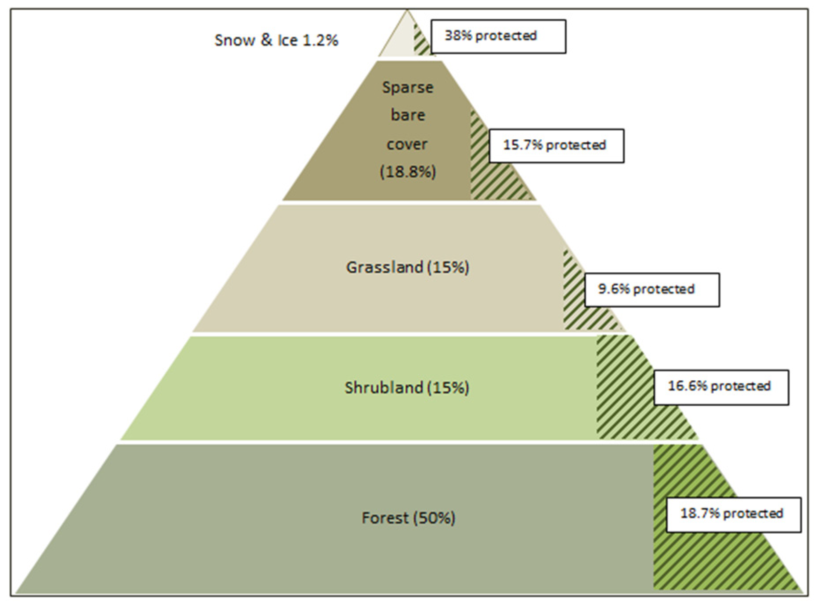
2.7. Mountain Moisture/Vegetation Classes: Coverage and Protection

To obtain a sub-biome, landscape-level perspective of coverage and protection, mountain areas were classified by moisture domains because moisture (along with temperature) is a key factor driving biotic distributions [17]. Mountain Ecosystems were identified using 15 moisture/vegetation classes based on World Vegetation and 2015 Land-Cover Data and World Moisture Domains [17]. This approach resulted in the identification of 77 Mountain Ecosystems (of the 278 natural or semi-natural World Ecosystems). Area coverage and level of protection of the moisture/vegetation classes in mountains are outlined in Table 2.

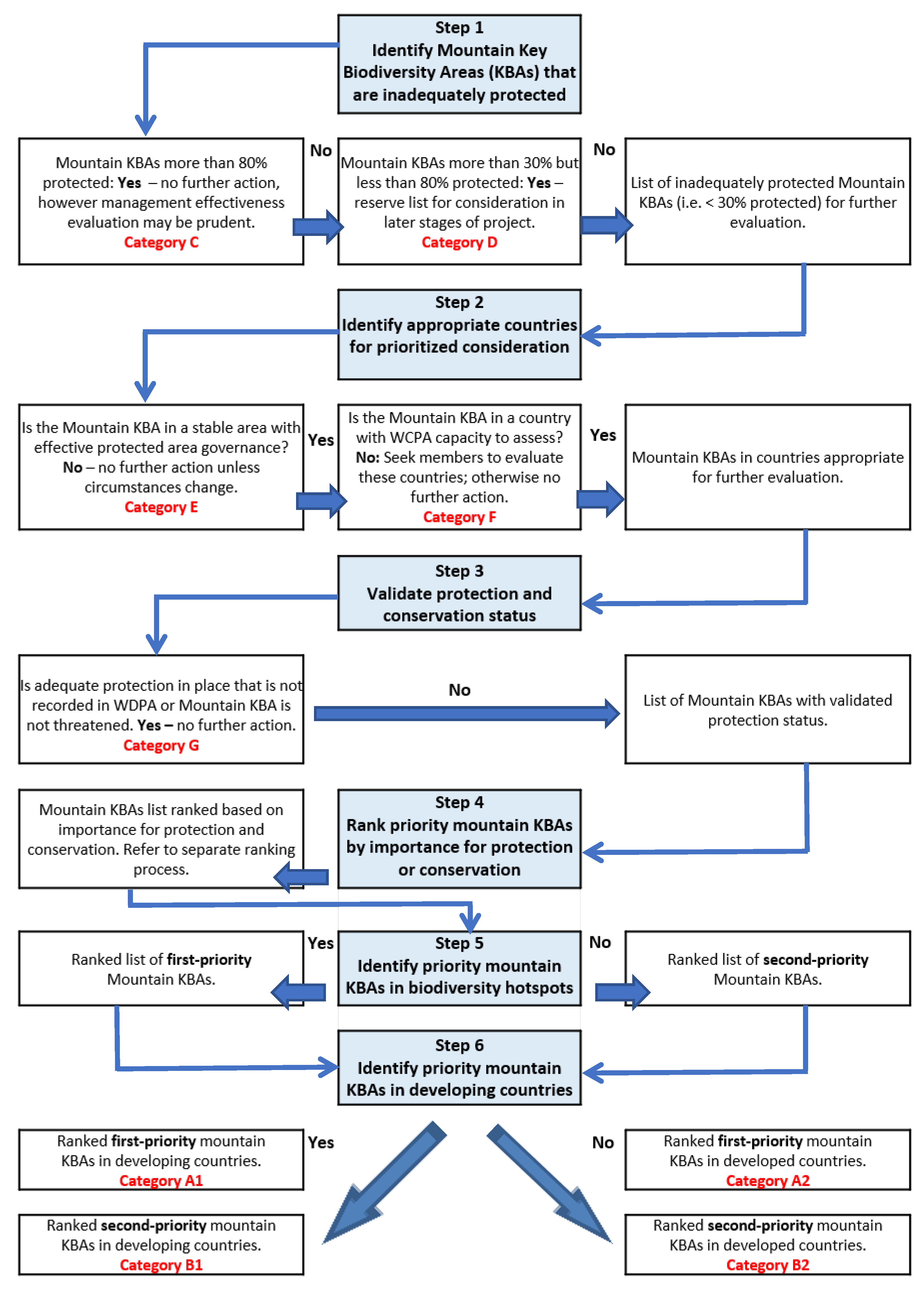
2.8. Decision-Support Tool for Prioritizing Mountain Areas for Protection and Conservation

A decision-support tool for identifying inadequately protected mountain KBAs and prioritizing their importance for protection is summarized in Figure 3. The algorithm-type framework or decision-tree contains six iterative steps for allocating ca. 6000 mountain KBAs to various categories, each prompting different actions. Data and maps of global protected areas and KBAs by biogeographical realm were derived from the UNEP–WCMC and Birdlife International spatial coverages that supported the preparation of the Protected Planet Report and Sustainable Development Goals in 2016 (Indicator 15.4.1: “coverage by protected areas of important sites for mountain biodiversity”). Protection status was derived from the WDPA and KBA status from the World Database of KBAs [48,50,51,52].
The mountain KBA maps were discussed at a workshop of the IUCN World Conservation Congress (WCC) in Hawaii (USA) in 2016. Subsequently, the tool was developed with broad stakeholder engagement for design, reliance on principles of conservation ecology, and a robust consultation process including peer review. The United States Geological Survey has provided new data on World Terrestrial Ecosystems and their level of protection [17]. This product was presented at the IUCN WCC in Marseilles (France) in 2021 with feedback incorporated into final design and trial application. We tested this method in the Western Himalaya Case Study Area (see Section 2.9).

2.8.1. Step 1: Identification of Inadequately Protected Mountain KBAs

The first step in this process of prioritizing mountain areas for protection identifies mountain KBAs considered inadequately protected and which require further examination. “Inadequately protected” is defined as those mountain KBAs for which less than 30% of their area is protected or conserved. “Protected or conserved areas” are those KBAs that are listed on the WDPA as a protected area or OECM following IUCN definitions [39]. Data sources are detailed below.
AttributeData Source
Protected areasWorld Database of Protected Areas [48]
KBA data and mapsWorld Database of KBAs [50]
KBA and protected area statusIntegrated Biodiversity Assessment Tool [51,52]
Quantification of global coverage of KBAs by protected areasData held by IUCN WCPA Mountains Specialist Group [51]

2.8.2. Step 2: Identification of Appropriate Countries for Heightened Consideration

The second step considers countries where there are inadequately protected mountain KBAs from step 1 to determine if they are appropriate for further evaluation. Prioritization and heightened consideration will focus on countries that are relatively politically stable, have capacity and resources to build on an established network of protected or conserved areas, and where the assessment team (e.g., WCPA or in-country agencies) has access to regional representatives with appropriate expertise and local knowledge.
AttributeData Source
Suitability of country to proceed with assessmentAssessing the suitability of a country is rather subjective. Guidance of the relevant IUCN regional representatives and protected area experts should therefore be sought.
Availability of in-country expertise for assessment of KBAsRegional in-country expertise and knowledge is crucial for accurate validation of the protection status of KBAs in step 3 and to assess and rank other protected area values in step 4. The IUCN WCPA Mountains Specialist Group regional representatives will determine if such support is available. If this expertise is not available or accessible at this stage, the assessment of KBAs in that country will be set aside, until adequate capacity becomes available.

2.8.3. Step 3: Validation of Protection and Conservation Status of Mountain KBAs

The third step validates the information available on the WDPA and the UNEP–WCMC analysis of spatial overlap between KBA polygons and WDPA polygons [51] using the list of inadequately protected KBAs from steps 1 and 2. This should be performed by regional experts with access to on-the-ground local knowledge. Mountain KBAs initially identified as being inadequately protected may, upon further investigation, be noted as adequately protected or conserved through unregistered de facto instruments. These may be OECMs, Territories of Life (ICCAs), or protected areas that have not yet been registered on the WDPA and/or choose not to be formally recognized. Information in the WDPA may also be incorrect. Additionally, even if not formally protected or conserved, some mountain KBAs may not be at risk or under any threat and thus would remain a lower priority for action. Only those mountain KBAs where a status of inadequate protection is validated move to step 4 for further consideration.
AttributeData Source
Protection and conservation statusProtected area specialists and regional representatives of the IUCN WCPA Mountains Specialist Group to assist the validation of protection and conservation status [40].

2.8.4. Step 4: Ranking of Priority Mountain KBAs by Importance, Urgency, and Viability

The fourth step evaluates each mountain KBA on the list of inadequately protected KBAs in countries that can accommodate further evaluation and that have had their protection status validated. These KBAs will be scored and ranked as candidates for prioritized consideration against a range of additional values and attributes that individually and collectively contribute to increasing their likelihood of protection. Rankings are based on cumulative scores as calculated in the decision-support tool (Figure 3). This evaluation is undertaken at the regional level; cumulative scores rank the importance of each mountain KBA within the region. A broad range of mountain values and attributes are assessed to confirm and augment the significance of protecting and/or conserving mountain KBAs. Attributes and supporting data are listed below.
AttributeData Source
Presence of inadequately protected world ecosystems[17]
Opportunity to enhance connectivity IUCN–WCPA Guidelines for Conserving Connectivity through Ecological Networks and Corridors [60];
Conservation Corridors [61]
Presence of flagship or iconic species or ecological communitiesA flagship species is a charismatic species selected to act as an ambassador, icon, or symbol for a defined habitat. Iconic species or ecological communities may be internationally recognized or determined by regional expertise. The snow leopard is an example for High Asia [62].
Presence of Red List species[55]
Presence of Red List ecosystems[57]
Wide range of elevation gradientsQualitative assessment based on local knowledge and expertise; see also [23]
Conservation of KBAs would provide benefits to local mountain communities, mainly through the protection of critical resources and provision of ecosystem servicesIUCN–WCPA Tools for Measuring, Modelling, and Valuing Ecosystem Services [63]
Protection of cultural sites, cultural heritage, and cultural landscapesQualitative assessment based on regional and in-country cultural heritage information and World Heritage Cultural Sites [64]
Ecotourism opportunities that benefit mountain communitiesQualitative assessment based on local knowledge and inputs from the tourism industry and ecotourism strategies;
IUCN–WCPA Tourism and Visitor Management in Protected Areas: Guidelines for Sustainability [65]
Peace building across bordersQualitative assessment based on local knowledge in transboundary scenarios;
IUCN Commission of Environment, Economic, and Social Policy (CEESP) and IUCN–WCPA Global Transboundary Conservation Network Transboundary Diagnostic Tool [66]
Vulnerability to climate change and/or opportunity to mitigate the impacts of climate changeQualitative assessment based on regional knowledge and on climate change mitigation and adaptation plans.
Disaster Risk Reduction (DRR)Qualitative assessment based on regional knowledge and risk assessments;
Reducing Vulnerability: The Role of Protected Areas in Mitigating Natural Disasters [67]; IUCN–WCPA Natural Solutions: Protected Areas as Tools for Disaster Risk Reduction [68];
IUCN–WCPA Helping Nature Help Us: Transforming Disaster Risk Reduction Through Ecosystem Management [69];
IUCN–WCPA Safe Havens: Protected Areas for Disaster Risk Reduction and Climate Change Adaptation [70]

2.8.5. Step 5: Identification of Priority Mountain KBAs Located in Biodiversity Hotspots

The fifth step determines whether mountain KBAs on the ranked list from step 4 occur in biodiversity hotspots. By definition, biodiversity hotspots have very high threat values (see Section 2.4). KBAs located in globally recognized biodiversity hotspots are listed as the first priorities, the second priority list being those not in biodiversity hotspots.
AttributeData Source
Biodiversity HotspotsCritical Ecosystem Partnership Fund [54]

2.8.6. Step 6: Identification of Priority KBAs in Developing Countries

In step six, first and second priority ranked lists of mountain KBAs from step 5 are separated into those from developing (~largely global south) and developed countries (~ largely global north). Many inadequately protected or conserved mountain KBAs occur in developing countries. One potential source of funding to support the establishment of new protected or conserved areas in developing countries through grants or concessional funding is the Global Environment Facility (GEF).
AttributeData Source
Developing versus developed countriesThe UNDP Human Development Index [71];
International Monetary Fund’s World Economic Outlook Database [72]

2.9. Case Study: Western Himalaya Case Study Area

As a case study, we applied the decision-support tool (Figure 3) to identify priority areas for mountain conservation in the Western Himalaya Case Study Area (WHCSA). The WHCSA spans most of the northern Indian states of Ladakh, Jammu and Kashmir, Himachal Pradesh, and Uttarakhand, and extends across Nepal and southwestern Tibet in China (Figure 4). The WHCSA was selected because of its high biodiversity and cultural value; the availability of mountain KBA and other data; its relatively poor levels of protection; and on-the-ground expertise was available from members of the project team. The KBA maps identifying unprotected and inadequately protected mountain KBAs in the WHCSA were also intended to inform a regional workshop attracting local expertise to initiate a fine-filter prioritization process.

2.10. Application, Scale, and Limitations

The decision-support tool was originally designed to inform the work of the IUCN WCPA and, by extension, government and NGO conservation agencies, particularly those in the mountain community, to facilitate protection and conservation of the highest-priority sites. Application of the decision-support tool may suit a variety of governance models and levels of institutional capacity. It is a rapid and strategic assessment approach with a global reach that makes use of existing global datasets aimed at galvanizing relatively prompt action where it is needed most. It aims to be a catalyst for further extensive discussions involving on-the-ground knowledge and truthing, including multistakeholder consultations at multiple spatial and organizational scales. However, although this decision-support tool and assessment process has the potential for wider application by a more diverse range of user groups focusing on other world ecosystems beyond the mountain sphere, it does not preclude the use of other approaches. These alternatives may be equally or even more important, based on the evaluation of other factors and/or with more detailed country-specific systematic conservation planning.
This technique relies heavily on mountain KBAs. They are but one way to initiate a global strategic assessment of natural values of mountain landscapes important for the persistence of biodiversity and human well-being. For some regions, current limitations on capacity and technology may mean that it will take some time to compile the necessary data and level of detail to demonstrate whether sites meet the quantitative thresholds associated with the KBA criteria. In addition, some protected or conserved areas may be important for other reasons (e.g., maintaining productivity, ecosystem services, aesthetics, and cultural heritage). Mountain KBAs should not necessarily override other important values that are identified in other regional assessments; however, it may advantageously complement these, and their results may be assessed in tandem, each confirming and strengthening the other or in some instances highlighting the need for more refined investigation. Furthermore, we want to caution against assuming all KBAs worth conserving will become protected areas; this may not be possible or even desirable. Mountain areas identified through this tool as priorities for new protected areas may upon further analysis and reflection be more suitable for the strengthening of existing sociocultural mechanisms and conservation outcomes through mechanisms such as OECMs or Territories of Life. Furthermore, KBAs do not always include all taxonomic groups, meaning that this approach may overlook other important mountain biota and areas requiring attention. Finally, the identification of protected and conserved areas does not assume that conservation objectives will be effectively met. Ascertaining whether the area is effectively managed is not the purpose of this approach, but the process remains a fundamental aspect of achieving positive outcomes for biodiversity in the long term. The IUCN has guidelines for assessing governance approaches [45] and management effectiveness [73].

3. Results

3.1. The Decision-Support Tool in General

Application of the decision-support tool (Figure 3) resulted in nine categories of priority and action (Table 3). The four categories for follow-up action are ranked in order of their importance and hence priority for further action:
  • Category A1: First-priority mountain KBAs situated within biodiversity hotspots in developing countries;
  • Category A2: First-priority mountain KBAs situated within biodiversity hotspots in developed countries;
  • Category B1: Second-priority mountain KBAs situated outside biodiversity hotspots in developing countries;
  • Category B2: Second-priority mountain KBAs situated outside biodiversity hotspots in developed countries.

3.2. Western Himalaya Case Study Area

This working example showcases the application of the decision-support tool and its value in strategically and rapidly identifying candidate areas requiring urgent protection (see Table 4 and Table 5 and Figure 5).
Step 1: Identification of Inadequately Protected Mountain KBAs—An area-based analysis in the WHCSA identified 33 mountain KBAs regarded as inadequately protected (<30% protected); these are listed for further assessment. Fifty-one mountain KBAs in the WHCSA are 30–100% protected; these will not be assessed further at this stage.
Step 2: Identification of Appropriate Countries for Heightened Consideration—India, Nepal, and China are considered realistic for heightened focus on conservation of KBAs, owing to each having a relatively stable government and protected area system, together with locally based IUCN WCPA staff or affiliates available to lead further assessments.
Step 3: Validation of Protection and Conservation Status of Mountain KBAs—This step requires regional in-country experts to validate WDPA data. Subject to completing this step, all 33 KBAs proceed to step 4.
Step 4: Ranking of Priority Mountain KBAs by Importance, Urgency, and Viability—An analysis by regional in-country specialists of various values and world mountain ecosystems indicates that of the 33 inadequately protected KBAs, 29 also contain inadequately protected world mountain ecosystems.
Step 5: Identification of Priority Mountain KBAs Located in Biodiversity Hotspots—The 33 inadequately protected mountain KBAs occur in an area largely congruent with the Himalaya Biodiversity Hotspot [74].
Step 6: Identification of Priority KBAs in Developing Countries—India, China, and Nepal are classified as developing countries according to the UNDP Human Development Index [71] and International Monetary Fund’s World Economic Outlook Database [72].
The assessment thus indicates that all 33 inadequately protected KBAs in the WHCSA will be Category A1: first-priority mountain KBAs (in biodiversity hotspots and developing countries), unless it is found that their protection status is under-reported when assessed by regional specialists. The ranking of importance may also be subject to further regional assessments.
Figure 5. Case study showing the protection status of mountain KBAs and mountain ecosystems in the core region of the WHCSA [75], represented by the Western Himalaya Indian States covering most of (top to bottom): Ladakh (i), Jammu and Kashmir (ii), Himachal Pradesh (iii), and Uttarakhand (iv), together with Nepal (v). KBA boundaries and status in China are not shown. The WHCSA is not strictly congruent with country borders.
Land 12 01323 g005

4. Discussion and Conclusions

Mountains are extremely diverse and account for half of the world’s biodiversity hotspots [1,2,3,4]. Globally, mountains provide a diverse range of ecosystem services, with freshwater storage and supply arguably the most important [5,6]. It is therefore critical to safeguard mountains and mountain resources.
Mountains, however, are poorly protected [21,22]. There are numerous reasons, including conflicts over resource use, cultural and community concerns about formal protection mechanisms, political tensions, lack of political will, and/or lack of an appropriate statute or other protection mechanisms. Inadequate protection may also involve a lack of appreciation of current values or lack of recognition of the merits of formal protected area status and/or the range of protected area governance options available.
Protecting and conserving mountain social–ecological systems through formal recognition as protected areas with good governance and effective management and/or through other mechanisms such as OECMs and Territories of Life (ICCAs) is a critical component of area- and nature-based solutions. This will promote more sustainable, resilient, and healthy mountain regions and the well-being of local and downstream communities who depend on these essential regions. Identifying global conservation priorities for new mountain protected and conserved areas necessitates a strategic and scientific approach to ensure that areas of highest value and most in need of protection are rapidly and objectively identified as priority areas.
Given that mountain ecosystems are highly imperilled, and the life-essential support they provide to biodiversity, communities and humanity at large is at risk, we have developed a scientifically credible decision-support tool to identify and prioritize inadequately protected mountain areas for protection and conservation. Our iterative and spatially explicit approach uses a simple and transparent process to help conserve areas of biodiversity (and cultural) importance within the world’s mountain regions. It is intended to be applied in the most efficient, fair, and equitable ways possible. It can be augmented by several ancillary datasets offering meaningful data on priority species and ecosystems (e.g., World Ecosystem typologies, biodiversity hotspots, IUCN Red Lists, etc.). As a test case, the inadequately protected mountain KBAs identified in the WHCSA, part of the Himalaya global biodiversity hotspot, galvanizes first-priority action in mountain areas of developing countries requiring the most urgent protection or conservation. This further provides a foundation for fine-filtering through in-country experts, government, NGOs, and communities of interest in assessing a range of quantitative and qualitative factors that will further guide conservation actions. Culturally sensitive considerations are also vital when assessing mechanisms for protection and conservation, including the rights of indigenous peoples and other collective rights, as in many situations, mountain communities relate to nature in meaningful ways beyond the purely economic and they often consider the land not just as a natural resource but as their home [76,77].
Our approach aligns with and supports numerous IUCN and other global policy frameworks, such as the CBD Kunming–Montreal Global Biodiversity Framework, Sustainable Development Goal 15, and GEF priorities. The decision-support tool considers a range of governance options within IUCN protected area categories and governance approaches, including OECMs and Territories of Life. Through application of the decision-support tool over time, the entire mountain KBA network can potentially be allocated into one of nine categories, thereby ensuring the most streamlined and strategic form of action to safeguard the world’s most biodiverse mountain areas facing myriad threats in the Anthropocene.

Author Contributions

Conceptualization, P.J., C.C., E.A.B., J.M.F., M.M., S.O. and R.S.; tool development, P.J., C.C., E.A.B., J.M.F., M.M., S.O. and R.S.; writing—lead of first draft, P.J.; writing—cowriting, review, and editing, C.C., E.A.B., J.M.F., M.M., S.O. and R.S.; major revision and rewrite, C.C.; detailed review of revision, P.J., E.A.B., J.M.F., S.O. and R.S. All authors have read and agreed to the published version of the manuscript.

Funding

This research received no external funding.

Data Availability Statement

Not applicable.

Acknowledgments

The IUCN WCPA Mountains Specialist Group is thanked for support during this process. Diego Juffe-Bignoli is thanked for insights relating to Key Biodiversity Areas. Any use of trade, firm, or product names is for descriptive purposes only and does not imply endorsement by the U.S. Government.

Conflicts of Interest

The authors declare no conflict of interest.

References

  1. Körner, C.; Ohsawa, M. Mountain systems. In Ecosystems and Human Well-Being: Current State and Trends; Fitzharris, B., Shrestha, K., Eds.; Island Press: Washington DC, USA, 2005; pp. 681–716. [Google Scholar]
  2. Rahbek, C.; Borregaard, M.K.; Colwell, R.K.; Dalsgaard, B.; Holt, B.G.; Morueta-Holme, N.; Nogues-Bravo, D.; Whittaker, R.J.; Fjeldså, J. Humboldt’s enigma: What causes global patterns of mountain biodiversity? Science 2019, 365, 1108–1113. [Google Scholar] [CrossRef]
  3. Mittermeier, R.A.; Turner, W.R.; Larsen, F.W.; Brooks, T.M.; Gascon, C. Global biodiversity conservation: The critical role of hotspots. In Biodiversity Hotspots: Distribution and Protection of Conservation Priority Areas; Zachos, F.E., Habel, J.C., Eds.; Springer: Berlin/Heidelberg, Germany, 2011; pp. 3–22. [Google Scholar]
  4. Perrigo, A.; Hoorn, C.; Antonelli, A. Why mountains matter for biodiversity. J. Biogeogr. 2019, 47, 315–325. [Google Scholar] [CrossRef] [Green Version]
  5. Egan, P.A.; Price, M.F. Mountain Ecosystem Services and Climate Change: A Global Overview of Potential Threats and Strategies for Adaptation; Prepared for the UNESCO Programme Climate Change Impacts in Major Mountainous Regions of the World: Multidisciplinary Network for Adaptation Strategies (Africa, Asia, Latin America and Europe); UNESCO: Paris, France, 2017; pp. 1–33. [Google Scholar]
  6. Wehrli, A. Why mountains matter for sustainable development. Mt. Res. Dev. 2014, 34, 405–409. [Google Scholar] [CrossRef]
  7. Flint, C.G. Framing the human dimensions of mountain systems: Integrating social science paradigms for a global network of mountain observatories. Mt. Res. Dev. 2016, 36, 528–536. [Google Scholar] [CrossRef] [Green Version]
  8. Makino, Y.; Manuelli, S.; Hook, L. Accelerating the movement for mountain peoples and policies. Science 2019, 365, 1084–1086. [Google Scholar] [CrossRef]
  9. Björnsen Gurung, A. Alpine knowledge gardening: Research network for the advancement of science and development. In Challenges for Mountain Regions—Tackling Complexity; Borsdorf, A., Grabherr, G., Heinrich, K., Scott, B., Stötter, J., Eds.; Böhlau: Vienna, Austria, 2010; pp. 197–203. [Google Scholar]
  10. Beever, E.A.; Perrine, J.D.; Rickman, T.; Flores, M.; Clark, J.P.; Waters, C.; Weber, S.S.; Yardley, B.; Thoma, D.; Chesley-Preston, T.; et al. Pika (Ochotona princeps) losses from two isolated regions reflect temperature and water balance, but reflect habitat area in a mainland region. J. Mammal. 2016, 97, 1495–1511. [Google Scholar] [CrossRef] [Green Version]
  11. Payne, D.; Spehn, E.M.; Snethlage, M.; Fischer, M. Opportunities for research on mountain biodiversity under global change. Curr. Opin. Environ. Sustain. 2017, 29, 40–47. [Google Scholar] [CrossRef]
  12. Martín-López, B.; Leister, I.; Cruz, P.L.; Palomo, I.; Grêt-Regamey, A.; Harrison, P.A.; Lavorel, S.; Locatelli, B.; Luque, S.; Walz, A. Nature’s contributions to people in mountains: A review. PLoS ONE 2019, 14, e0217847. [Google Scholar] [CrossRef] [Green Version]
  13. Schirpke, U.; Wang, G.; Padoa-Schioppa, E. Editorial: Mountain landscapes: Protected areas, ecosystem services, and future challenges. Ecosyst. Serv. 2021, 49, 101302. [Google Scholar] [CrossRef]
  14. Nogués-Bravo, D.; Araújo, M.B.; Errea, M.P.; Martínez-Rica, J.P. Exposure of global mountain systems to climate warming during the 21st Century. Glob. Environ. Chang. 2007, 17, 420–428. [Google Scholar] [CrossRef]
  15. Pepin, N.C.; Arnone, E.; Gobiet, A.; Haslinger, K.; Kotlarski, S.; Notarnicola, C.; Palazzi, E.; Seibert, P.; Serafin, S.; Schöner, W.; et al. Climate changes and their elevational patterns in the mountains of the world. Rev. Geophys. 2022, 60, e2020RG000730. [Google Scholar] [CrossRef]
  16. Carbutt, C. The imperiled alpine grasslands of the Afrotropic realm. In Imperiled: The Encyclopedia of Conservation; DellaSala, D.A., Goldstein, M.I., Eds.; Elsevier: Amsterdam, The Netherlands, 2022; Volume 2, pp. 243–255. [Google Scholar]
  17. Sayre, R.; Karragullen, D.; Frye, C.; Boucher, T.; Wolff, N.H.; Breyer, S.; Wright, D.; Martin, M.; Butler, K.; Van Graafeiland, K.; et al. An assessment of the representation of ecosystems in global protected areas using new maps of World Climate Regions and World Ecosystems. Glob. Ecol. Conserv. 2020, 21, e00860. [Google Scholar] [CrossRef]
  18. UNEP-WCMC; IUCN. Protected Planet Report 2016; UNEP-WCMC: Cambridge, UK; IUCN: Gland, Switzerland, 2016; pp. 1–73. [Google Scholar]
  19. Joppa, L.N.; Pfaff, A. High and far: Biases in the location of protected areas. PLoS ONE 2009, 4, e8273. [Google Scholar] [CrossRef]
  20. Sanderson, E.W.; Segan, D.B.; Watson, J.E.M. Global status of and prospects for protection of terrestrial geophysical diversity. Conserv. Biol. 2015, 29, 649–656. [Google Scholar] [CrossRef]
  21. Rodríguez-Rodríguez, D.; Bomhard, B.; Butchart, S.H.M.; Foster, M.N. Progress towards international targets for protected area coverage in mountains: A multi-scale assessment. Biol. Cons. 2011, 144, 2978–2983. [Google Scholar] [CrossRef]
  22. Michalak, J.L.; Lawler, J.J.; Roberts, D.R.; Carroll, C. Distribution and protection of climatic refugia in North America. Conserv. Biol. 2018, 32, 1414–1425. [Google Scholar] [CrossRef]
  23. Elsen, P.R.; Monahan, W.B.; Merenlender, A.M. Global patterns of protection of elevational gradients in mountain ranges. Proc. Natl. Acad. Sci. USA 2018, 115, 6004–6009. [Google Scholar] [CrossRef] [PubMed] [Green Version]
  24. Chakraborty, A. Mountains as vulnerable places: A global synthesis of changing mountain systems in the Anthropocene. GeoJournal 2019, 2, 585–604. [Google Scholar] [CrossRef]
  25. Bentley, L.K.; Robertson, M.P.; Barker, N.P. Range contraction to a higher elevation: The likely future of the montane vegetation in South Africa and Lesotho. Biodivers. Conserv. 2019, 28, 131–153. [Google Scholar] [CrossRef] [Green Version]
  26. Rapacciuolo, G.; Maher, S.P.; Schneider, A.C.; Hammond, T.T.; Jabis, M.D.; Walsh, R.E.; Iknayan, K.J.; Walden, G.K.; Oldfather, M.F.; Ackerly, D.D.; et al. Beyond a warming fingerprint: Individualistic biogeographic responses to heterogeneous climate change in California. Glob. Chang. Biol. 2014, 20, 2841–2855. [Google Scholar] [CrossRef] [Green Version]
  27. Freeman, B.G.; Lee-Yaw, J.A.; Sunday, J.M.; Hargreaves, A.L. Expanding, shifting and shrinking: The impact of global warming on species’ elevational distributions. Glob. Ecol. Biogeogr. 2018, 27, 1268–1276. [Google Scholar] [CrossRef]
  28. Rumpf, S.B.; Hülber, K.; Zimmermann, N.E.; Dullinger, S. Elevational rear edges shifted at least as much as leading edges over the last century. Glob. Ecol. Biogeogr. 2019, 28, 533–543. [Google Scholar] [CrossRef]
  29. Bellard, C.; Bertelsmeier, C.; Leadley, P.; Thuiller, W.; Courchamp, F. Impacts of climate change on the future of biodiversity. Ecol. Lett. 2012, 15, 365–377. [Google Scholar] [CrossRef] [PubMed] [Green Version]
  30. Beier, P.; Brost, B. Use of land facets to plan for climate change: Conserving the arenas, not the actors. Conserv. Biol. 2010, 24, 701–710. [Google Scholar] [CrossRef]
  31. Beever, E.A.; Mattsson, B.J.; Germino, M.J.; Post Van Der Burg, M.; Bradford, J.B.; Brunson, M.W. Successes and challenges from formation to implementation of eleven broad-extent conservation programs. Conserv. Biol. 2014, 28, 302–314. [Google Scholar] [CrossRef] [PubMed] [Green Version]
  32. Carbutt, C.; Thompson, D.I. Mountain watch: How LT(S)ER is safeguarding Southern Africa’s people and biodiversity for a sustainable mountain future. Land 2021, 10, 1024. [Google Scholar] [CrossRef]
  33. CBD. The Ecosystem Approach, Convention on Biological Diversity (Guidelines); Secretariat of the Convention on Biological Diversity: Montreal, QC, Canada, 2004; pp. 1–50. [Google Scholar]
  34. Shepherd, G. The Ecosystem Approach: Five Steps to Implementation (Ecosystem Management Series No. 3); IUCN Commission on Ecosystem Management: Gland, Switzerland, 2004; pp. 1–30. [Google Scholar]
  35. IUCN. Nature-Based Solutions to Address Global Societal Challenges; Cohen-Shacham, E., Walters, G., Janzen, C., Maginnis, S., Eds.; IUCN: Gland, Switzerland, 2016; pp. 1–97. [Google Scholar]
  36. Cohen-Shacham, E.; Andrade, A.; Dalton, J.; Dudley, N.; Jones, M.; Kumar, C.; Maginnis, S.; Maynard, S.; Nelson, C.R.; Renaud, F.G.; et al. Core principles for successfully implementing and upscaling Nature-based Solutions. Environ. Sci. Policy 2019, 98, 20–29. [Google Scholar] [CrossRef]
  37. IUCN. Global Standard for Nature-based Solutions. A User-friendly Framework for the Verification, Design and Scaling Up of NbS, 1st ed.; IUCN: Gland, Switzerland, 2020; pp. 1–21. [Google Scholar]
  38. UN. The Millennium Development Goals Report; United Nations: New York, NY, USA, 2011; pp. 1–68. [Google Scholar]
  39. IUCN. Guidelines for Applying Protected Area Management Categories; Dudley, N., Ed.; IUCN: Gland, Switzerland, 2008; pp. 1–86. [Google Scholar]
  40. IUCN-WCPA Task Force on OECMs. Recognising and Reporting Other Effective Area-Based Conservation Measures; IUCN: Gland, Switzerland, 2019; pp. 1–22. [Google Scholar]
  41. ICCA Registry—An Online Information Platform for Indigenous and Community Conserved Areas. Available online: https://www.iccaregistry.org/ (accessed on 19 June 2023).
  42. ICCA Consortium. Territories of Life: 2021 Report; ICCA Consortium: Worldwide, 2021; pp. 1–244. Available online: https://livereport.protectedplanet.net/pdf/Protected_Planet_Report_2018.pdf (accessed on 19 June 2023).
  43. Zanjani, L.V.; Govan, H.; Jonas, H.C.; Karfakis, T.; Mwamidi, D.M.; Stewart, J.; Walters, G.; Dominguez, P. Territories of life as key to global environmental sustainability. Curr. Opin. Environ. Sustain. 2023, 63, 101298. [Google Scholar] [CrossRef]
  44. Sajeva, G.; Borrini-Feyerabend, G.; Niederberger, T. Meanings and More... Policy Brief of the ICCA Consortium; ICCA Consortium in Collaboration with Cenesta: Washington, DC, USA, 2019; pp. 1–59. [Google Scholar]
  45. Borrini-Feyerabend, G.; Hill, R. Governance for the conservation of nature. In Protected Area Governance and Management; Worboys, G.L., Lockwood, M., Kothari, A., Feary, S., Pulsford, I., Eds.; ANU Press: Canberra, Australia, 2015; pp. 169–206. [Google Scholar]
  46. UNEP-WCMC; IUCN; NGS. Protected Planet Report 2018; UNEP-WCMC: Cambridge, UK; IUCN: Gland, Switzerland; NGS: Washington, DC, USA, 2018; pp. 1–56. [Google Scholar]
  47. CBD. Kunming-Montreal Global Biodiversity Framework; CBD: Montreal, QC, Canada, 2022; pp. 1–7. [Google Scholar]
  48. Protected Planet—World Database of Protected Areas. Available online: https://www.protectedplanet.net/en (accessed on 12 January 2021).
  49. IUCN. A Global Standard for the Identification of Key Biodiversity Areas; IUCN: Gland, Switzerland, 2016; pp. 1–37. [Google Scholar]
  50. World Database of Key Biodiversity Areas. Available online: http://www.keybiodiversityareas.org/home (accessed on 11 November 2020).
  51. Protected Area Coverage of Key Biodiversity Areas. Available online: https://bipdashboard.natureserve.org/bip_metadata/protected-area-coverage-key-biodiversity (accessed on 13 September 2020).
  52. Integrated Biodiversity Assessment Tool. Available online: http://www.ibat-alliance.org (accessed on 21 September 2021).
  53. Biodiversity Hotspots: Targeted Investment in Nature’s Most Important Places. Available online: www.conservation.org/priorities/biodiversity-hotspots (accessed on 21 October 2020).
  54. Critical Ecosystem Partnership Fund. Available online: https://www.cepf.net/our-work/biodiversity-hotspots (accessed on 13 April 2021).
  55. The IUCN Red List of Threatened Species. Available online: https://www.iucnredlist.org/ (accessed on 12 July 2020).
  56. The IUCN Commission for Ecosystem Management. Available online: https://www.iucn.org/theme/ecosystem-management/our-work (accessed on 3 April 2021).
  57. The IUCN Red List of Threatened Ecosystems. Available online: https://www.iucn.org/theme/ecosystem-management/our-work/red-list-ecosystems (accessed on 19 March 2020).
  58. Possingham, H.P.; Wilson, K.A.; Andelman, S.J.; Vynne, C.H. Protected areas: Goals, limitations, and design. In Principles of Conservation Biology, 3rd ed.; Groom, M.J., Meffe, G.K., Carroll, C.R., Eds.; Sinauer Associates: Sunderland, MA, USA, 2006; pp. 507–549. [Google Scholar]
  59. Andren, H. Effects of habitat fragmentation on birds and mammals in landscapes with different proportions of suitable habitat: A review. Oikos 1994, 71, 355–366. [Google Scholar] [CrossRef] [Green Version]
  60. Hilty, J.; Worboys, G.L.; Keeley, A.; Woodley, S.; Lausche, B.; Locke, H.; Carr, M.; Pulsford, I.; Pittock, J.; White, J.W.; et al. Guidelines for Conserving Connectivity Through Ecological Networks and Corridors; Best Practice Protected Area Guidelines Series No. 30; IUCN: Gland, Switzerland, 2020; pp. 1–122. [Google Scholar]
  61. Conservation Corridor—Connecting Science to Conservation. Available online: https://conservationcorridor.org/ (accessed on 20 June 2023).
  62. Global Snow Leopard and Ecosystem Protection Program. Available online: https://globalsnowleopard.org/ (accessed on 19 June 2023).
  63. Neugarten, R.A.; Langhammer, P.F.; Osipova, E.; Bagstad, K.J.; Bhagabati, N.; Butchart, S.H.M.; Dudley, N.; Elliott, V.; Gerber, L.R.; Gutierrez Arrellano, C.; et al. Tools for Measuring, Modelling, and Valuing Ecosystem Services: Guidance for Key Biodiversity Areas, Natural World Heritage Sites, and Protected Areas; IUCN: Gland, Switzerland, 2018; pp. 1–70. [Google Scholar]
  64. UNESCO World Heritage Convention—World Heritage List. Available online: https://whc.unesco.org/en/list/ (accessed on 20 June 2023).
  65. Leung, Y.-F.; Spenceley, A.; Hvenegaard, G.; Buckley, R. Tourism and Visitor Management in Protected Areas: Guidelines for Sustainability; Best Practice Protected Area Guidelines Series No. 27; IUCN: Gland, Switzerland, 2018; pp. 1–120. [Google Scholar]
  66. IUCN-WCPA Global Transboundary Conservation Network—Diagnostic Tool for Transboundary Conservation Planners. Available online: http://www.tbpa.net/page.php?ndx=22 (accessed on 20 June 2023).
  67. Dudley, N.; MacKinnon, K.; Stolton, S. Reducing vulnerability: The role of protected areas in mitigating natural disasters. In The Role of Ecosystems in Disaster Risk Reduction; Renaud, F.G., Sudmeier-Rieux, K., Estrella, M., Eds.; United Nations University Press: Tokyo, Japan, 2013; pp. 371–388. [Google Scholar]
  68. Dudley, N.; Buyck, C.; Furuta, N.; Pedrot, C.; Renaud, F.; Sudmeier-Rieux, K. Protected Areas as Tools for Disaster Risk Reduction. A Handbook for Practitioners; MOEJ: Tokyo, Japan; IUCN: Gland, Switzerland, 2015; pp. 1–44. [Google Scholar]
  69. Monty, F.; Murti, R.; Furuta, N. Helping Nature Help Us: Transforming Disaster Risk Reduction Through Ecosystem Management; IUCN: Gland, Switzerland, 2016; pp. 1–82. [Google Scholar]
  70. Murti, R.; Buyck, C. Safe Havens: Protected Areas for Disaster Risk Reduction and Climate Change Adaptation; IUCN: Gland, Switzerland, 2014; pp. 1–168. [Google Scholar]
  71. The United Nations Development Programme’s Human Development Reports. Human Development Indices and Indicators—Statistical Update 2018. Available online: https://hdr.undp.org/content/statistical-update-2018/ (accessed on 19 June 2023).
  72. International Monetary Fund. World Economic Outlook Database—Groups and Aggregates Information. Available online: https://www.imf.org/en/Publications/WEO/weo-database/2023/April/groups-and-aggregates (accessed on 31 May 2023).
  73. Hockings, M.; Stolton, S.; Leverington, F.; Dudley, N.; Courrau, J. Evaluating Effectiveness: A Framework for Assessing Management Effectiveness of Protected Areas, 2nd ed.; IUCN: Gland, Switzerland; Cambridge, UK, 2006; pp. 1–105. [Google Scholar]
  74. Himalaya Biodiversity Hotspot. Critical Ecosystem Partnership Fund—Protecting Biodiversity by Empowering People. Available online: https://www.cepf.net/our-work/biodiversity-hotspots/Himalaya (accessed on 19 June 2023).
  75. United States Geological Survey. Maps of Key Biodiversity Areas, World Ecosystems and Levels of Protection; United States Geological Survey: Reston, VA, USA, unpublished data.
  76. Foggin, J.M.; Brombal, D.; Razmkhah, A. Thinking like a mountain: Exploring the potential of relational approaches for transformative nature conservation. Sustainability 2021, 13, 12884. [Google Scholar] [CrossRef]
  77. Wirzba, N. The trouble with sustainability. Sustainability 2023, 15, 1388. [Google Scholar] [CrossRef]
Figure 1. Schematic of mountain biomes—proportion of each biome in the global mountain landscape (central column) and each biome’s level of protection (right-most hatching) (biome proportions do not include croplands or settlements). Based on [17]. The heights of each biome and % protection are not drawn to scale.
Land 12 01323 g001
Figure 2. Schematic representation of the relationship between conserved areas, protected areas, OECMs and Territories of Life (the size of shapes is not reflective of estimates of coverage, nor of the relative extent of their overlap) [44].
Land 12 01323 g002
Figure 3. Decision-support tool for the identification and prioritization of new mountain protected and conserved areas as global conservation priorities.
Land 12 01323 g003
Figure 4. Map of the mountains in Central Asia showing the approximate location of the Western Himalaya Case Study Area (broken white circle).
Land 12 01323 g004
Table 1. Protection levels of World Terrestrial Ecosystems occurring in mountains [17].
Mountain Terrestrial EcosystemsArea
(km2)
% Protected
IUCN Cat. I–IV
% Protected
IUCN Cat. I–VI
Area Protected
(km2)
Boreal Desert Sparsely or Nonvegetated on Mountains1530000
Boreal Desert Grassland on Mountains1803000
Cool Temperate Desert Grassland on Mountains33,6830.0060.0062
Polar Desert Grassland on Mountains9510.030.091
Warm Temperate Desert Forest on Mountains1080.050.661
Warm Temperate Desert Shrubland on Mountains23,3762.152.68626
Cool Temperate Dry Grassland on Mountains826,4321.43.3127,355
Tropical Desert Forest on Mountains58103.3419
Tropical Desert Shrubland on Mountains10,0540.63.34336
Polar Desert Snow and Ice on Mountains1103.920.4
Warm Temperate Dry Grassland on Mountains480,6531.635.7927,830
Tropical Dry Sparsely or Nonvegetated on Mountains401,9782.876.1724,802
Polar Dry Grassland on Mountains940,5073.266.6662,638
Subtropical Desert Forest on Mountains6024.097.1543
Cool Temperate Desert Sparsely or Nonvegetated on Mountains98,9245.247.367281
Warm Temperate Desert Grassland on Mountains25005.537.62191
Subtropical Moist Grassland on Mountains129,1111.977.9310,239
Boreal Dry Grassland on Mountains476,0826.428.0838,467
Cool Temperate Dry Sparsely or Nonvegetated on Mountains749,3174.978.6464,741
Warm Temperate Desert Sparsely or Nonvegetated on Mountains201,6813.648.8817,909
Cool Temperate Dry Shrubland on Mountains591,9416.199.0253,393
Warm Temperate Dry Sparsely or Nonvegetated on Mountains834,9912.749.1776,569
Warm Temperate Moist Grassland on Mountains176,1722.29.3516,472
Tropical Moist Sparsely or Nonvegetated on Mountains68934.2710.09696
Tropical Moist Grassland on Mountains43,9993.2710.354554
Cool Temperate Dry Forest on Mountains630,6617.1110.4665,967
Subtropical Moist Shrubland on Mountains525,3184.4310.5355,316
Boreal Moist Forest on Mountains3,544,0547.510.74380,631
Cool Temperate Desert Shrubland on Mountains11,8102.0610.831279
Subtropical Dry Sparsely or Nonvegetated on Mountains547,6473.3311.5563,253
Cool Temperate Desert Forest on Mountains196.0911.732
Boreal Dry Forest on Mountains894,4466.8811.82105,724
Boreal Dry Sparsely or Nonvegetated on Mountains323,3587.8612.0438,932
Boreal Dry Snow and Ice on Mountains12015.7512.22147
Warm Temperate Dry Shrubland on Mountains1,045,2595.1212.46130,239
Polar Dry Snow and Ice on Mountains60,4076.8812.617617
Polar Moist Grassland on Mountains722,8998.5912.9593,615
Tropical Desert Grassland on Mountains25571.3113.13336
Tropical Dry Grassland on Mountains111,4535.0113.1514,656
Cool Temperate Dry Snow and Ice on Mountains5499.213.2573
Boreal Moist Grassland on Mountains356,9298.5613.9949,934
Subtropical Dry Grassland on Mountains254,2973.515.138,399
Warm Temperate Moist Forest on Mountains2,265,8517.0615.43349,621
Tropical Desert Sparsely or Nonvegetated on Mountains364,3025.6615.6156,868
Polar Desert Shrubland on Mountains76452.9615.811209
Warm Temperate Moist Shrubland on Mountains158,9654.9316.0625,530
Polar Dry Sparsely or Nonvegetated on Mountains464,1527.6916.1374,868
Boreal Moist Shrubland on Mountains699,6509.916.17113,133
Tropical Dry Forest on Mountains306,8067.0116.650,930
Polar Dry Shrubland on Mountains81,7099.917.3314,160
Boreal Moist Sparsely or Nonvegetated on Mountains584,98512.5918.57108,632
Tropical Moist Shrubland on Mountains201,4107.1618.6337,523
Boreal Dry Shrubland on Mountains95,4618.3418.8718,013
Polar Dry Forest on Mountains34,62615.7818.916548
Tropical Dry Shrubland on Mountains311,5817.3519.1559,668
Subtropical Dry Forest on Mountains753,7745.6119.68148,342
Subtropical Dry Shrubland on Mountains999,3526.1421.03210,164
Subtropical Moist Forest on Mountains3,012,36810.621.35643,141
Cool Temperate Moist Grassland on Mountains439,0068.4321.4494,123
Polar Desert Sparsely or Nonvegetated on Mountains10,9777.7921.792392
Warm Temperate Dry Forest on Mountains561,6365.621.84122,661
Polar Moist Shrubland on Mountains168,80612.0922.2437,542
Cool Temperate Moist Forest on Mountains2,854,98312.2422.52642,942
Subtropical Desert Sparsely or Nonvegetated on Mountains505,82513.323.74120,083
Warm Temperate Moist Sparsely or Nonvegetated on Mountains11,61110.424.212811
Polar Desert Forest on Mountains306.6624.297
Polar Moist Sparsely or Nonvegetated on Mountains950,75418.9725.81245,390
Subtropical Moist Sparsely or Nonvegetated on Mountains79628.9326.052074
Subtropical Desert Grassland on Mountains875915.2129.252562
Tropical Moist Forest on Mountains2,076,01012.130.11625,087
Polar Moist Forest on Mountains179,17019.8130.5654,754
Subtropical Desert Shrubland on Mountains20,82222.3832.666800
Cool Temperate Moist Shrubland on Mountains275,86522.1337.88104,498
Cool Temperate Moist Sparsely or Nonvegetated on Mountains139,26725.7938.8554,105
Boreal Moist Snow and Ice on Mountains32,72936.2139.6712,984
Polar Moist Snow and Ice on Mountains298,44033.4442.67127,344
Cool Temperate Moist Snow and Ice on Mountains10,71154.7860.096436
Total33,962,744 5,663,230
Table 2. Moisture/vegetation classes ranked by proportion in mountains (area and level of protection). Data are derived from [17].
Moisture/Vegetation ClassesSize (km2)% of Global Total Area of MountainsArea Protected
(km2)
% Protection
Desert Snow and Ice on Mountains110.000030.433.9
Desert Forest on Mountains13400.00395735.4
Desert Grassland on Mountains50,2530.1479730916.2
Dry Snow and Ice on Mountains62,1570.18302783612.6
Desert Shrubland on Mountains73,7070.2170210,25013.9
Moist Snow and Ice on Mountains341,8801.00663146,76442.9
Desert Sparsely or Nonvegetated on Mountains1,183,2393.48393204,53217.3
Dry Grassland on Mountains3,089,4249.09651209,3456.8
Moist Grassland on Mountains1,868,1165.50049268,93714.4
Dry Sparsely or Nonvegetated on Mountains3,321,4439.77967343,16510.3
Moist Shrubland on Mountains2,030,0145.97718373,54218.4
Moist Sparsely or Nonvegetated on Mountains1,701,4725.00982413,70724.3
Dry Shrubland on Mountains3,125,3039.20215485,63815.5
Dry Forest on Mountains3,181,9499.36894500,17215.7
Moist Forest on Mountains13,932,43641.022702,696,17619.4
Total Area33,962,744 5,663,22916.7
Table 3. Categories of priority and action for mountain KBAs identified through the decision-support tool.
Categories for Priority Consideration for Enhanced Protection StatusCategories for No Further Action Unless Circumstances Substantially ChangeCategories Indicating That Adequate Protection Status Is Already Achieved
Category A1: List of ranked first-priority mountain KBAs occurring in developing countries (and within biodiversity hotspots).Category E: mountain KBAs <30% protected but in unstable areas or with no effective system or capacity for protected area governance in place.
No further consideration unless circumstances change.
Category C: mountain KBAs >80% protected; no further action for now; however, management effectiveness evaluation may be prudent.
Category A2: List of ranked first-priority mountain KBAs occurring in developed countries (and within biodiversity hotspots).Category F: mountain KBAs <30% protected but no IUCN WCPA Mountains Specialist Group contacts to assess steps 3 and 4. Mountains Specialist Group to seek members that can evaluate KBAs in these countries;
Otherwise, no further action.
Category D: mountain KBAs >30% but <80% protected; reserve list for consideration in later stages of project.
Category B1: List of ranked second priority mountain KBAs occurring in developing countries (and not within biodiversity hotspots). Category G: OECMs, Territories of Life or other arrangements in place (i.e., not registered on the WDPA) or adequately protected mountain KBAs or mountain KBAs not threatened. No further action.
Category B2: List of ranked second priority mountain KBAs occurring in developed countries (and not within biodiversity hotspots).
Table 4. The number of mountain KBAs and their protection status in India, Nepal, and China.
CountryMountain
KBAs
Mountain KBAs 80–100%
Protected
Mountain KBAs 30–80%
Protected
Mountain KBAs <30% Protected
India3175165201
Nepal231238
China4192230367
Total7598598576
Table 5. The number of mountain KBAs and their protection status in the Western Himalaya Case Study Area (WHCSA) of India, Nepal, and China.
CountryMountain
KBAs in WHCSA
Mountain KBAs 80–100%
Protected
Mountain KBAs 30–80%
Protected
Mountain KBAs <30% Protected
India58142222
Nepal231238
China3003
Total84262533
Disclaimer/Publisher’s Note: The statements, opinions and data contained in all publications are solely those of the individual author(s) and contributor(s) and not of MDPI and/or the editor(s). MDPI and/or the editor(s) disclaim responsibility for any injury to people or property resulting from any ideas, methods, instructions or products referred to in the content.

