
Pattern and Trend of Ecosystem Service Value in the Loess Plateau of Northern Shaanxi

 , , and
Abstract
1. Introduction
2. Materials and Methods
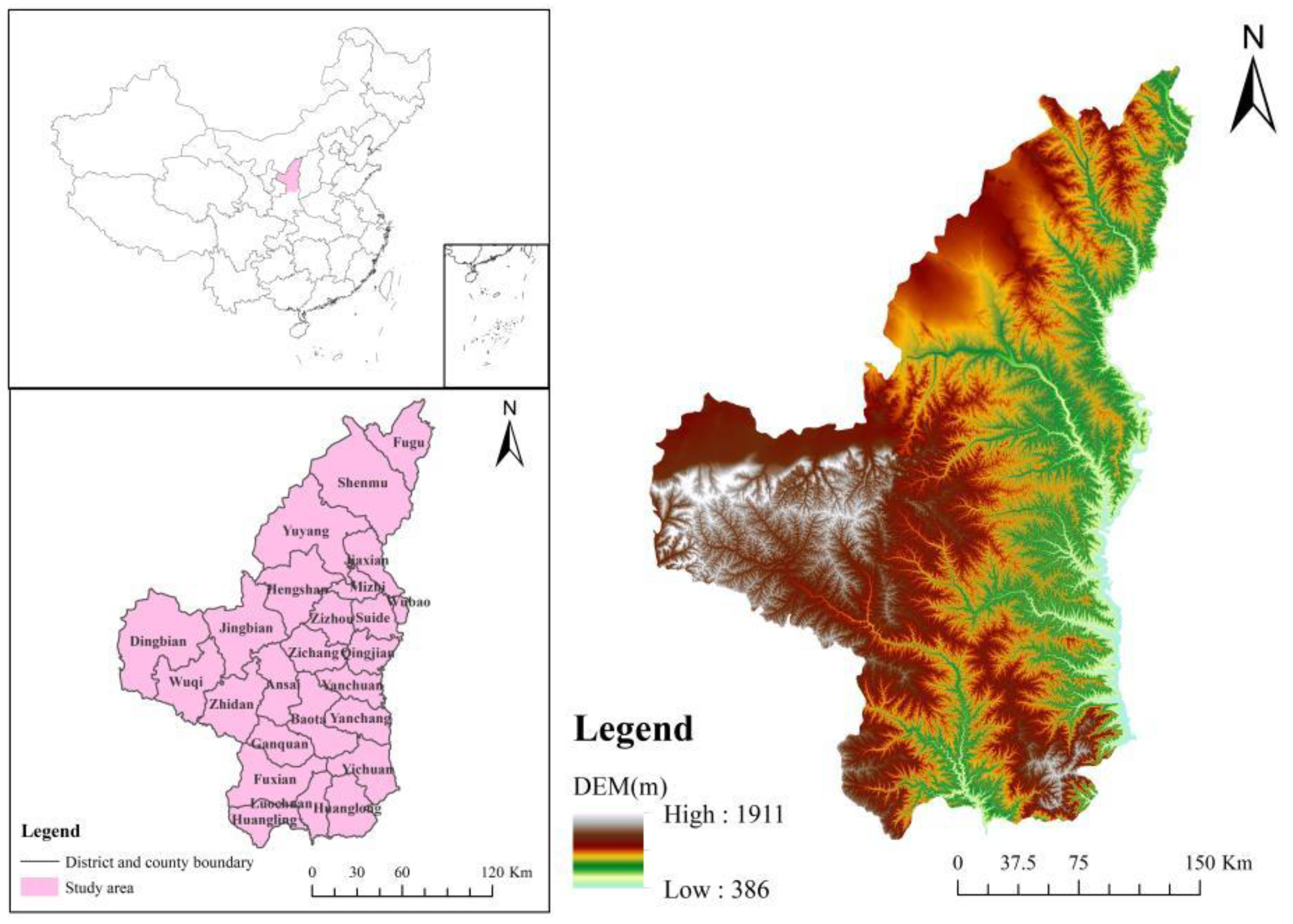
2.1. Study Area
2.2. Data
2.3. Methods
2.3.1. Miami Model
2.3.2. Spatial-Autocorrelation-Analysis Method
2.3.3. Entropy Weight Method
2.3.4. CA–Markov Model
3. Results
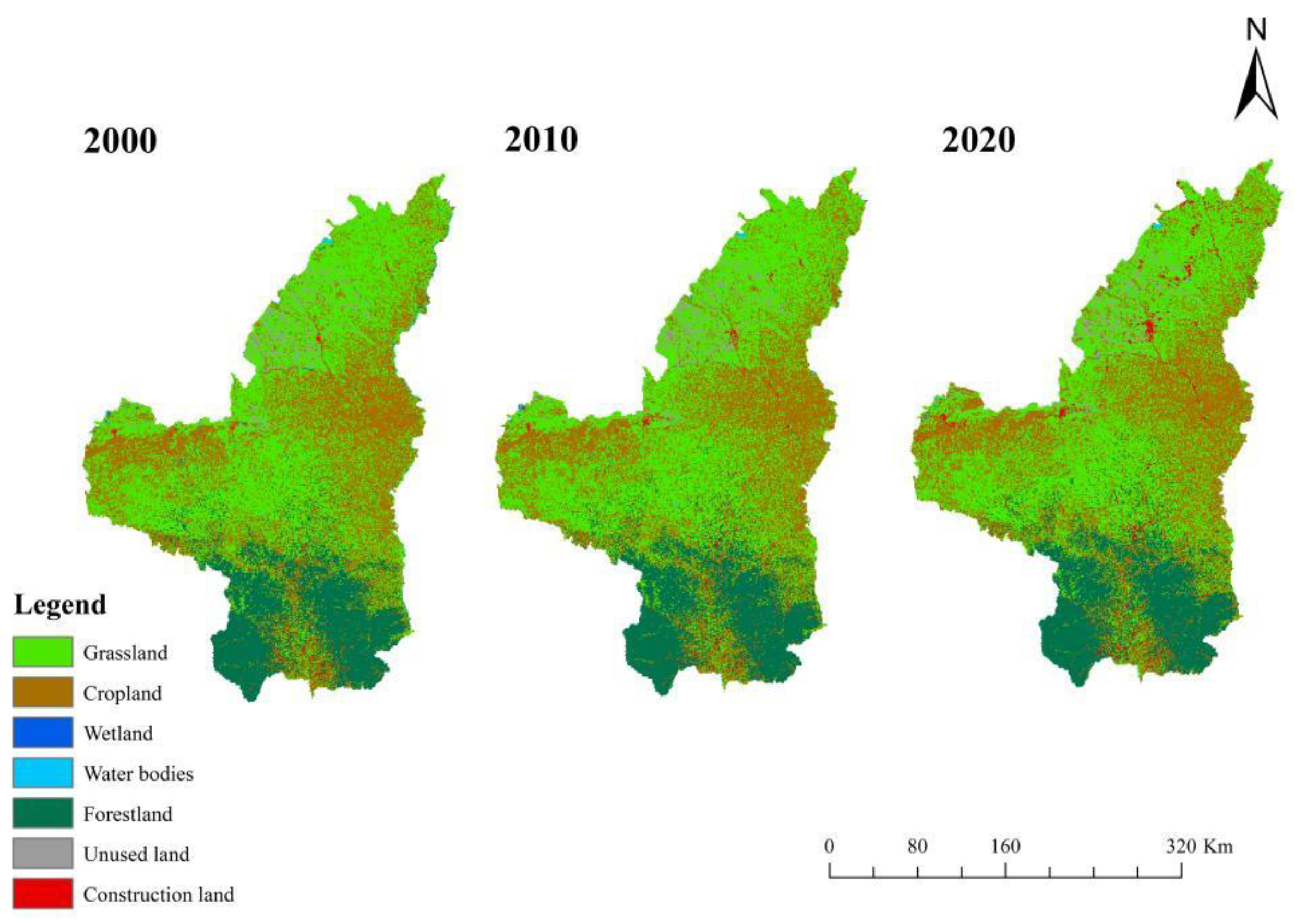
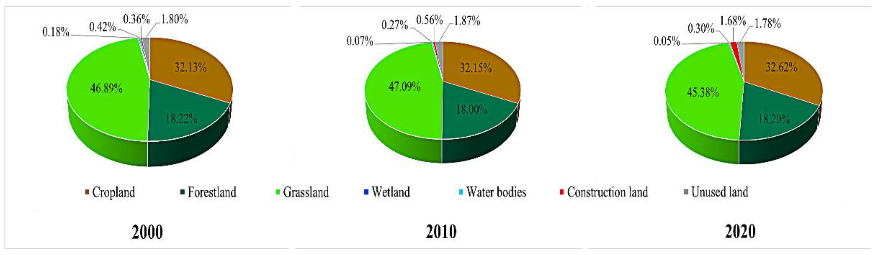
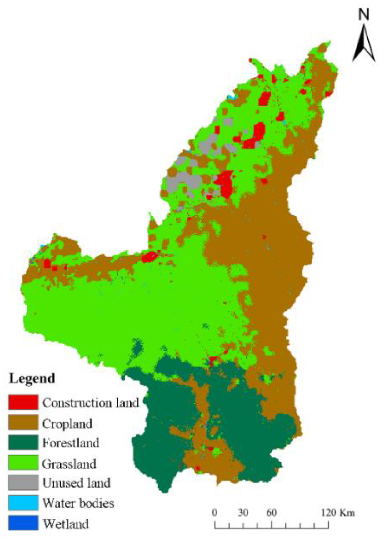
3.1. Land-Use Status Analysis
3.2. ESV Analysis
3.2.1. Revision of the ESV
3.2.2. Changes in the ESV
3.2.3. Changes in the Individual ESV
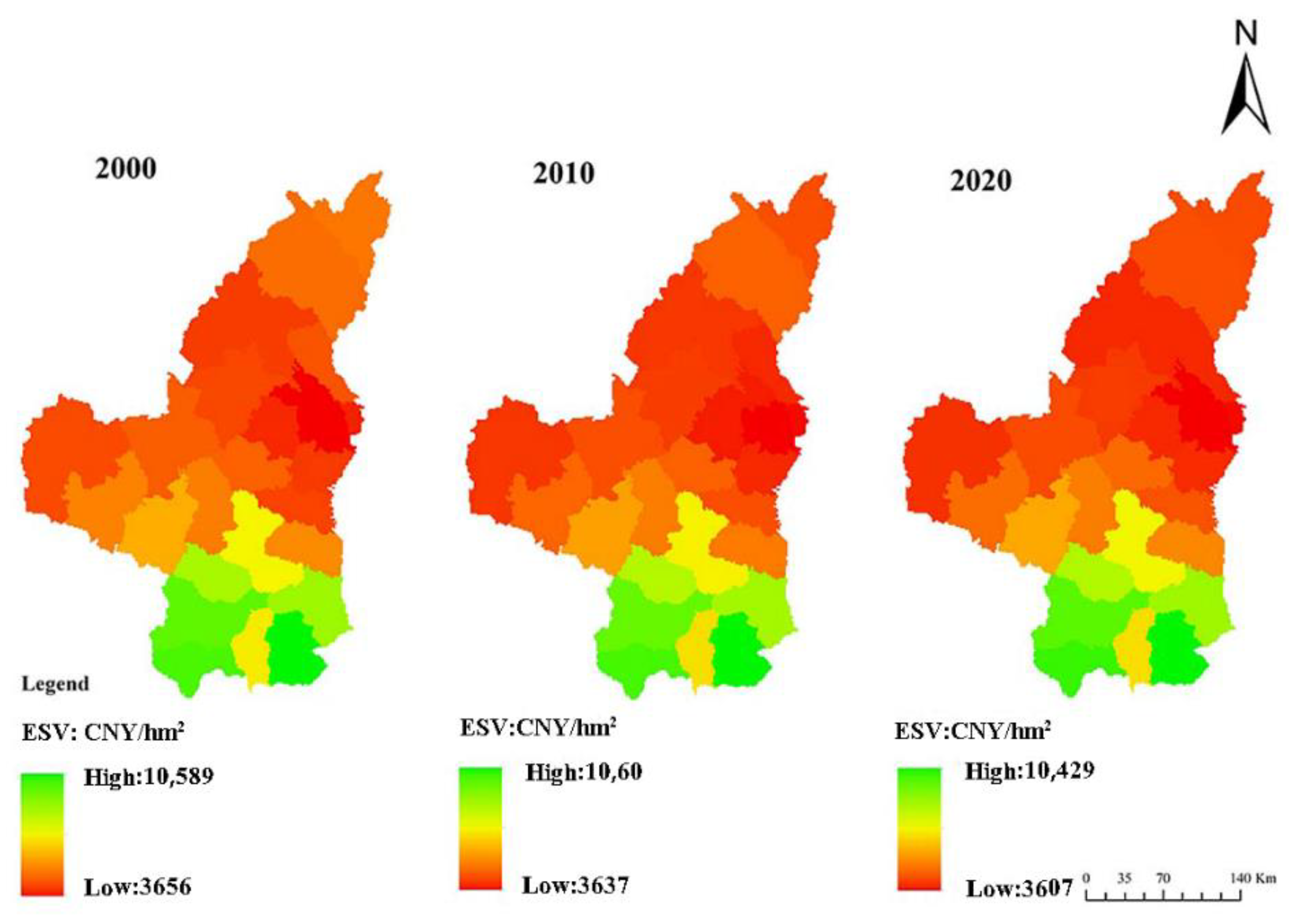
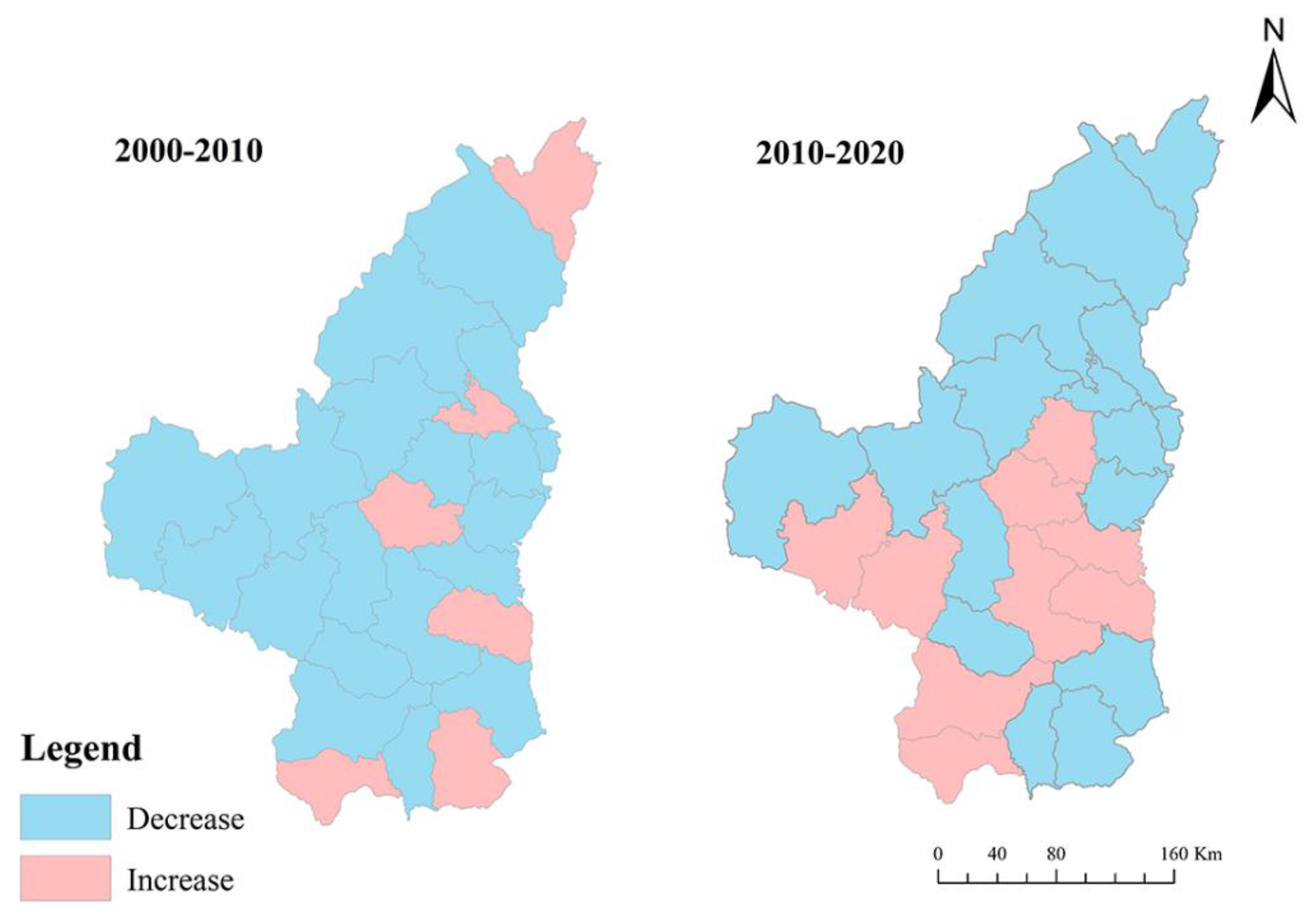
3.2.4. Changes in the ESV at the District and County Scales
3.3. The Spatial Distribution Pattern of the ESV
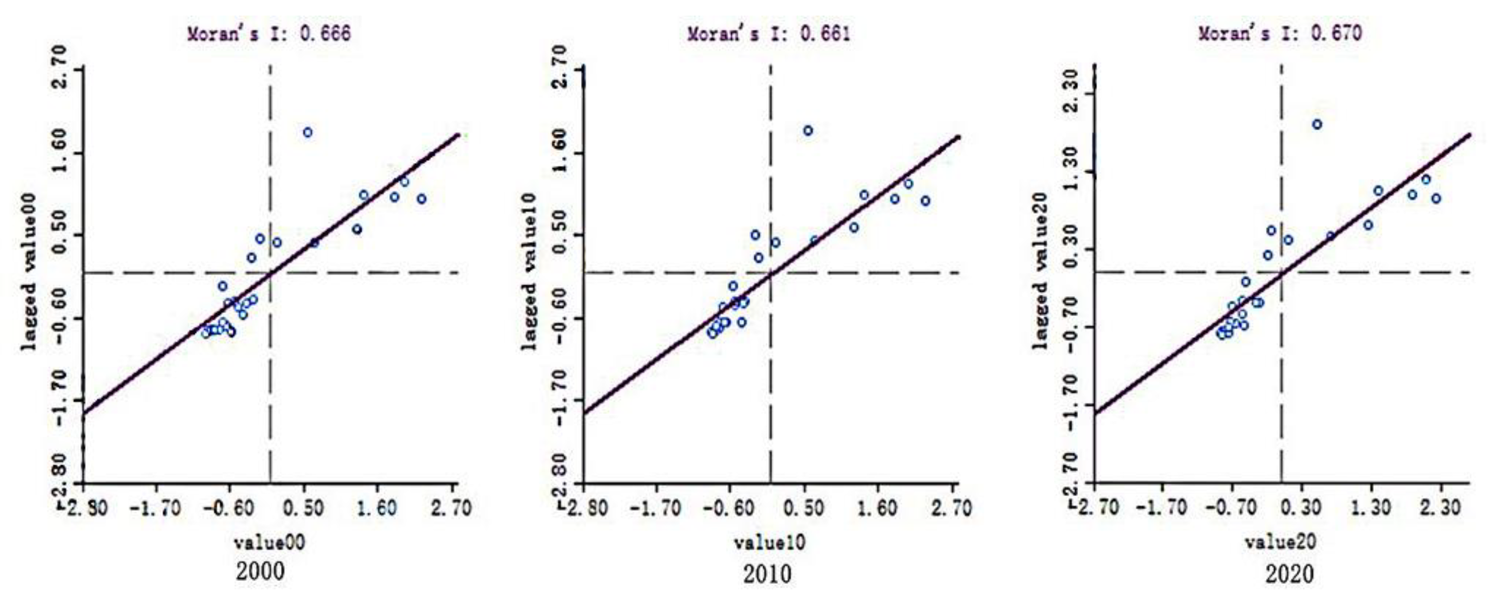
3.3.1. Global Spatial Autocorrelation Analysis
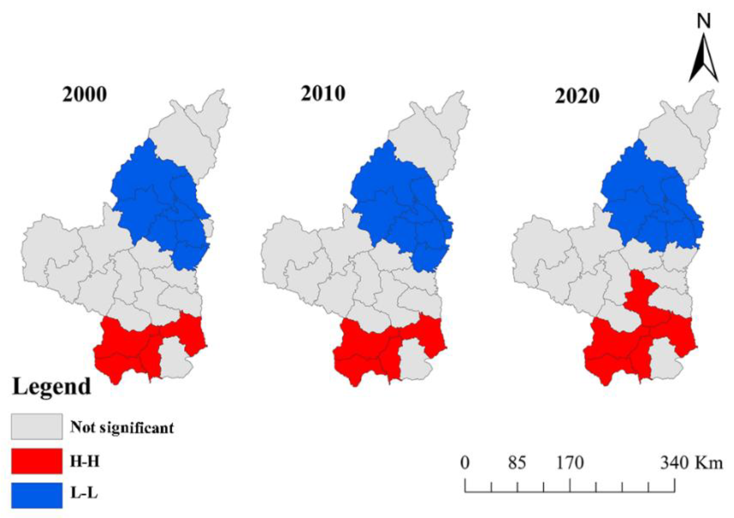
3.3.2. Local Spatial Autocorrelation Analysis
3.4. Influencing Factors of the ESV
3.4.1. Impact of Annual Rainfall on the ESV
3.4.2. Impact of Temperature on the ESV
3.4.3. Impact of Slope on the ESV
3.4.4. Impact of Soil Types on the ESV
3.4.5. Impact of Elevation on the ESV
3.4.6. Impact of Population Density on the ESV
3.4.7. Impact of Roads on the ESV
3.5. Weight Analysis of Influencing Factors and Comprehensive Evaluation
3.5.1. Weighting Analysis of Influencing Factors
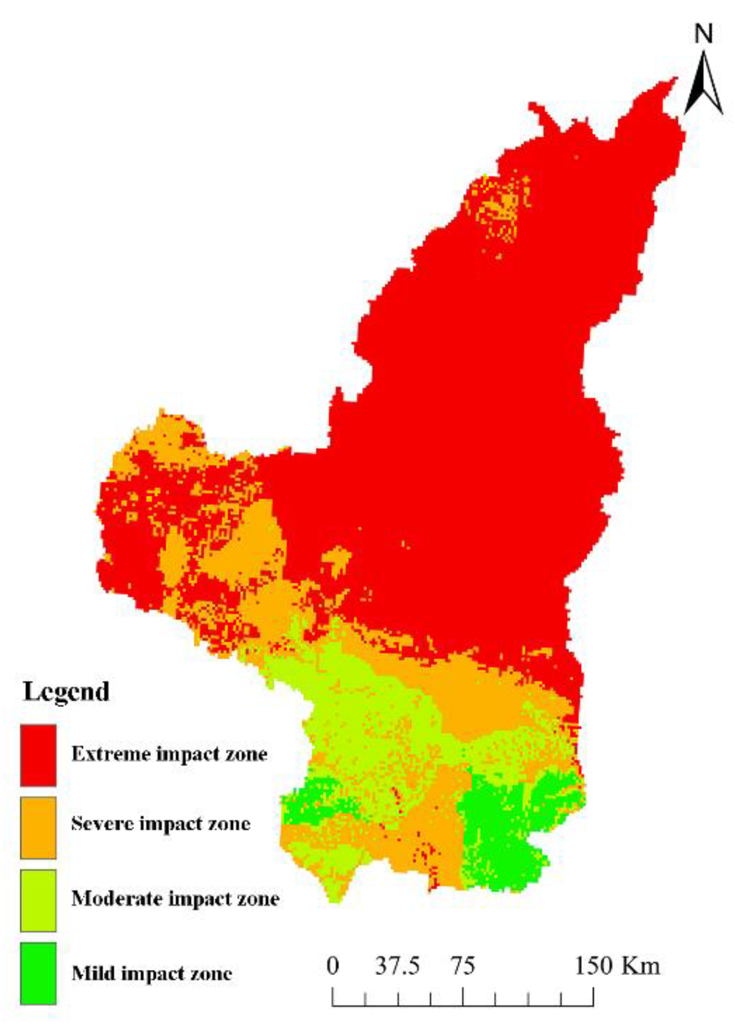
3.5.2. Comprehensive Evaluation of Influencing Factors
3.6. Forecast of the ESV Trend
4. Discussion
4.1. Temporal and Spatial Change Mechanism of the ESV
4.2. Influencing of Various Factors on the ESV
4.3. Trend Forecast Analysis of the ESV
4.4. Policy Implications
4.5. Limitations and Future Work
5. Conclusions
Author Contributions
Funding
Institutional Review Board Statement
Informed Consent Statement
Data Availability Statement
Acknowledgments
Conflicts of Interest
References
- Costanza, R.; d’Arge, R.; de Groot, R.; Farber, S.; Grasso, M.; Hannon, B.; Limburg, K.; Naeem, S.; O’Neill, R.V.; Paruelo, J.; et al. The value of the world’s ecosystem services and natural capital. Nature 1997, 387, 253–260. [Google Scholar] [CrossRef]
- Finlayson, M.; Cruz, R.; Davidson, N.; Alder, J.; Cork, S.; de Groot, R.; Lévêque, C.; Milton, G.; Peterson, G.; Pritchard, D. Millennium Ecosystem Assessment: Ecosystems and Human Well-Being: Wetlands and Water Synthesis; Island Press: Washington, DC, USA, 2005. [Google Scholar]
- Costanza, R.; de Groot, R.; Sutton, P.; van der Ploeg, S.; Anderson, S.J.; Kubiszewski, I.; Farber, S.; Turner, R.K. Changes in the global value of ecosystem services. Glob. Environ. Chang. 2014, 26, 152–158. [Google Scholar] [CrossRef]
- De Groot, R.; Brander, L.; Van Der Ploeg, S.; Costanza, R.; Bernard, F.; Braat, L.; Christie, M.; Crossman, N.; Ghermandi, A.; Hein, L.; et al. Global estimates of the value of ecosystems and their services in monetary units. Ecosyst. Serv. 2012, 1, 50–61. [Google Scholar] [CrossRef]
- Jing, Y.; Chen, L.; Sun, R. A Theoretical Research Framework for Ecological Security Pattern Construction Based on Ecosystem Services Supply and Demand. Acta Geogr. Sin. 2018, 38, 4121–4131. [Google Scholar]
- Xu, L.; Yu, B.; Yue, W. A method of green GDP accounting based on eco-service and a case study of Wuyishan, China. Procedia Environ. Sci. 2010, 2, 1865–1872. [Google Scholar] [CrossRef]
- Li, G.; Fang, C. Global mapping and estimation of ecosystem services values and gross domestic product: A spatially explicit integration of national ‘green GDP’ accounting. Ecol. Indic. 2014, 46, 293–314. [Google Scholar] [CrossRef]
- Varela, E.; Verheyen, K.; Valdés, A.; Soliño, M.; Jacobsen, J.B.; De Smedt, P.; Ehrmann, S.; Gärtner, S.; Górriz, E.; Decocq, G. Promoting biodiversity values of small forest patches in agricultural landscapes: Ecological drivers and social demand. Sci. Total Environ. 2017, 619–620, 1319–1329. [Google Scholar] [CrossRef]
- Pedersen, E.; Weisner, S.E.; Johansson, M. Wetland areas’ direct contributions to residents’ well-being entitle them to high cultural ecosystem values. Sci. Total Environ. 2019, 646, 1315–1326. [Google Scholar] [CrossRef]
- Wong, C.; Jiang, B. Quantifying multiple ecosystem services for adaptive management of green infrastructure. Ecosphere 2018, 9, 1–27. [Google Scholar] [CrossRef]
- Kremer, P.; Hamstead, Z.A.; McPhearson, T. The value of urban ecosystem services in New York City: A spatially explicit multicriteria analysis of landscape scale valuation scenarios. Environ. Sci. Policy 2016, 62, 57–68. [Google Scholar] [CrossRef]
- Yang, J.; Guan, Y.; Xia, J.; Jin, C.; Li, X. Spatiotemporal variation characteristics of green space ecosystem service value at urban fringes: A case study on Ganjingzi District in Dalian, China. Sci. Total Environ. 2018, 639, 1453–1461. [Google Scholar] [CrossRef]
- Lu, M.; Zhang, Y.; Liang, F.; Wu, Y. Spatial Relationship between Land Use Patterns and Ecosystem Services Value—Case Study of Nanjing. Land 2022, 11, 1168. [Google Scholar] [CrossRef]
- Xin, Z.; Li, C.; Liu, H.; Shang, H.; Ye, L.; Li, Y.; Zhang, C. Evaluation of Temporal and Spatial Ecosystem Services in Dalian, China: Implications for Urban Planning. Sustainability 2018, 10, 1247. [Google Scholar] [CrossRef]
- Xie, G.; Zhen, L.; Lu, C.; Xia, Y.; Chen, C. Expert Knowledge Ledge Based Valuation Method of Ecosytem Services in China. J. Nat. Resour. 2008, 23, 911–919. [Google Scholar]
- Xie, G.; Zhang, C.; Zhang, L.; Chen, W.; Li, S. Improvement of the Evaluation Method for Ecosystem Service Value Based on Per Unit Area. J. Nat. Resour. 2015, 30, 1243–1254. [Google Scholar]
- Crossman, N.D.; Bryan, B.A. Identifying cost-effective hotspots for restoring natural capital and enhancing landscape multi-functionality. Ecol. Econ. 2009, 68, 654–668. [Google Scholar] [CrossRef]
- Marre, J.B.; Th´ebaud, O.; Pascoe, S.; Jennings, S.; Boncoeur, J.; Coglan, L. Is economic valuation of ecosystem services useful to decisionmakers? Lessons learned from Australian coastal and marine management. Environ. Manag. 2016, 178, 52–62. [Google Scholar]
- Wang, S.; Liu, Z.; Chen, Y.; Fang, C. Factors influencing ecosystem services in the Pearl River Delta, China: Spatiotemporal differentiation and varying importance. Resour. Conserv. Recycl. 2021, 168, 105477. [Google Scholar] [CrossRef]
- Ma, W.; Yang, F.; Wang, N.; Zhao, L.; Tan, K.; Zhang, X.; Zhang, L.; Li, H. Study on Spatial-temporal Evolution and Driving Factors of Ecosystem Service Value in the Yangtze River Delta Urban Agglomerations. J. Ecol. Rural. 2022, 38, 1365–1376. [Google Scholar]
- Braun, D.; De Jong, R.; Schaepman, M.; Furrer, R.; Hein, L.; Kienast, F.; Damm, A. Ecosystem service change caused by climatological and non-climatological drivers: A Swiss case study. Ecol. Appl. 2019, 29, e01901. [Google Scholar] [CrossRef]
- Qiu, L.; Pan, Y.; Zhu, J.; Amable, G.S.; Xu, B. Integrated analysis of urbanization-triggered land use change trajectory and implications for ecological land management: A case study in Fuyang, China. Sci. Total Environ. 2019, 660, 209–217. [Google Scholar] [CrossRef]
- Yu, Y.; Li, J.; Zhou, Z.; Ma, X. Response of Multiple Mountain E-cosystem Services on Environmental Gradients: How to Respond, and Where Should Be Priority Conservation? J. Clean Prod. 2021, 278, 123264. [Google Scholar] [CrossRef]
- Li, W.; Wang, L.; Yang, X.; Liang, T.; Zhang, Q.; Liao, X.; White, J.R.; Rinklebe, J. Interactive influences of meteorological and socioeconomic factors on ecosystem service values in a river basin with different geomorphic features. Sci. Total Environ. 2022, 829, 154595. [Google Scholar] [CrossRef] [PubMed]
- Liu, S.; Liu, L.; Wu, X.; Hou, X.; Zhao, S.; Liu, G. Quantitative evaluation of human activity intensity on the regional ecological impact studies. Acta Geogr. Sin. 2018, 38, 6797–6809. [Google Scholar]
- Pan, N.; Guan, Q.; Wang, Q.; Sun, Y.; Li, H.; Ma, Y. Spatial Differentiation and Driving Mechanisms in Ecosystem Service Value of Arid Region: A case study in the middle and lower reaches of Shule River Basin, NW China. J. Clean. Prod. 2021, 319, 128718. [Google Scholar] [CrossRef]
- Peng, J.; Tian, L.; Liu, Y.; Zhao, M.; Hu, Y.; Wu, J. Ecosystem services response to urbanization in metropolitan areas: Thresholds identification. Sci. Total Environ. 2017, 607–608, 706–714. [Google Scholar] [CrossRef]
- Jiang, D.; Ma, W.; Zou, F.; Li, H.; Zhang, L.; Liu, G. Spatio-temporal Changes of Ecosystem Service Value in Dalou Mountain Area at Township Scale. Resour. Environ. Sci. 2020, 33, 2713–2723. [Google Scholar]
- Zhang, Y.; Zhao, X.; Zuo, L.; Zhang, Z. The impact of land use change on ecosystem services value in Loess Plateau. Remote Sens. Nat. Resour. 2019, 31, 132–139. [Google Scholar]
- Jiang, W.; Fu, B.; Lü, Y. Assessing Impacts of Land Use/Land Cover Conversion on Changes in Ecosystem Services Value on the Loess Plateau, China. Sustainability 2020, 12, 7128. [Google Scholar] [CrossRef]
- Fang, X.; Tang, G.; Li, B.; Han, R. Spatial and Temporal Variations of Ecosystem Service Values in Relation to Land Use Pattern in the Loess Plateau of China at Town Scale. PLoS ONE 2018, 9, e110745. [Google Scholar] [CrossRef]
- Xie, G.; Lu, C.; Leng, Y.; Zheng, D.; Li, S. Ecological assets valuation of the Tibetan Plateau. J. Nat. Resour. 2013, 18, 189–196. [Google Scholar]
- Gao, Y.; Li, J.; Liu, R.; Wang, Z.; Wang, H. Temporal and spatial evolution of greenspace system and evaluation of ecosystem services in the core area of the Yangtze River Delta. Chin. J. Ecol. 2020, 39, 956–968. [Google Scholar]
- Lan, Z.; Jia, L.; Cheng, Y. The ecosystem services evaluation and trade-off synergy in Min River Basin. Acta Geogr. Sin. 2020, 40, 3909–3920. [Google Scholar]
- Wang, N.; Yang, G.; Han, X.; Jia, G.; Liu, F. Land Use Change and Ecosystem Service Value in Inner Mongolia From 1990 to 2018. J. Soil Water Conserv. 2020, 34, 244–255. [Google Scholar]
- Gong, H.; Cao, L.; Duan, Y.; Jiao, F.; Xu, X.; Zhang, M.; Wang, K.; Liu, H. Multiple effects of climate changes and human activities on NPP increase in the Three-north Shelter Forest Program area. For. Ecol. Manag. 2023, 529, 120732. [Google Scholar] [CrossRef]
- Li, Y.; Han, L.; Zhu, H.; Zhao, Y.; Liu, Z.; Chen, R. Changes of Ecological Service Value in Yanan City Pre and Post Returning Farmland to Forestland Based on Land Use. J. Northwest A&F Univ. 2020, 35, 203–211. [Google Scholar]
- Zhang, J.; Zhou, W. Spatial Autocorrelation Between Topographic Relief and Population/Economy in Sichuan Province. Bull. Soil Water Conserv. 2019, 39, 250–257. [Google Scholar]
- Moran, P.A.P. The Interpretation of Statistical Maps. J. R. Stat. Soc. Ser. B Methodol. 1948, 10, 243–251. [Google Scholar] [CrossRef]
- Wu, Z.; Zhang, F.; Di, D.; Wang, H. Study of spatial distribution characteristics of river eco-environmental values based on emergy-GeoDa method. Sci. Total Environ. 2021, 802, 149679. [Google Scholar] [CrossRef]
- Xu, B.; Zhou, Y.; Xu, L.; Yu, L.; Wu, W. Spatial characteristics analysis of ecological system service value in QianJiang City of Hubei Province. Acta Geogr. Sin. 2011, 31, 7379–7387. [Google Scholar]
- TU, X.; Long, H. Spatial Patterns and Dynamic Evolution of Ecosystem Service Values in Poyang Lake Region From 2000 to 2010. Res. Sci. 2015, 37, 2451–2460. [Google Scholar]
- Cheng, W.; Xi, H.; Sindikubwabo, C.; Si, J.; Zhao, C.; Yu, T.; Li, A.; Wu, T. Ecosystem health assessment of desert nature reserve with entropy weight and fuzzy mathematics methods: A case study of Badain Jaran Desert. Ecol. Indic. 2020, 119, 106843. [Google Scholar] [CrossRef]
- Ni, J.; Li, P.; Wei, C.; Xie, D. Potentialities evaluation of regional land consolidation based on AHP and entropy weight method. Trans. CSAE. 2009, 25, 202–209. [Google Scholar]
- Yang, J.; Wang, J.; Shao, L.; Li, Y.; Zhao, B.; Jia, X.; Luo, Q. Comprehensive Evaluation of New Fresh Edible Sweet-glutinous Maize Varieties Based on Entropy Weight Method. Asian J. Agric. Res. 2018, 10, 92–94. [Google Scholar]
- Yang, Q.; Lin, A.; Zhao, Z.; Zou, L.; Sun, C. Assessment of Urban Ecosystem Health Based on Entropy Weight Extension Decision Model in Urban Agglomeration. Sustainability 2016, 8, 869. [Google Scholar] [CrossRef]
- Pontius, R.G.; Shusas, E.; McEachern, M. Detecting important categorical land changes while accounting for persistence. Agric. Ecosyst. Environ. 2004, 101, 251–268. [Google Scholar] [CrossRef]
- Ling, C.; Ju, H.; Zhang, H.; Sun, H. Study on the Forecast of Wetland Resources Changes in Beijing Based on CA-MARKOV Model. Chinese Agr. Sci. Bull. 2012, 28, 262–269. [Google Scholar]
- Wang, Q.; Liu, D.; Gao, F.; Zheng, X.; Shang, Y. A Partitioned and Heterogeneous Land-Use Simulation Model by Integrating CA and Markov Model. Land 2023, 12, 409. [Google Scholar] [CrossRef]
- Luo, Z.; Hu, X.; Wei, B.; Cao, P.; Cao, S.; Du, X. Urban Landscape Pattern Evolution and Prediction Based on Multi-Criteria CA-Markov Model: Take Shanghang County as an Example. Econ. Geogr. 2020, 40, 58–66. [Google Scholar]
- Zheng, Q.; Luo, G.; Zhu, L.; Zhou, D. Prediction of landscape patterns in Ili River Delta based on CA-Markov model. Chin. J. Appl. Ecol. 2010, 21, 873–882. [Google Scholar]
- Huang, C.; Liu, G. A Review of the Application of Cellular Models. Prog. Geogr. 2005, 24, 105–115. [Google Scholar]
- Sang, L.; Zhang, C.; Yang, J.; Zhu, D.; Yun, W. Simulation of land use spatial pattern of towns and villages based on CA–Markov model. Math. Comput. Model. 2011, 54, 938–943. [Google Scholar] [CrossRef]
- Zhang, X.; Cui, W. Integrating GIS with Cellular Automaton Model to Establish a New Approach for Spatio-temporal Process Simulation and Prediction. Acta Geod. Et Cartogr. Sin. 2001, 30, 148–155. [Google Scholar]
- Guo, J.; Pan, J. Evolution and Prediction of Thermal Environment Pattern in Nanjing Based on CA-Markov Model. J. Atmos. Environ. Opt. 2020, 15, 143–153. [Google Scholar]
- Zhang, Y.; Zhang, F.; Wang, J.; Ren, Y.; Ghulam, A.; Kung, H. Ecological risk assessment and prediction of Ebinur Lake region based on Land use/Land cover change. China Environ. Sci. 2016, 36, 3465–3474. [Google Scholar]
- Wu, J.; Tian, Y.; Xu, W.; Xiao, Y.; Xie, Y.; Cheng, Y. Scenario Analysis of Land Use Change in the Lower Reaches of Wujiang River Based on CA-Markov Model. Resour. Soil Water Conserv. 2017, 24, 133–139. [Google Scholar]
- Qiu, H.; Hu, B.; Zhang, Z. Impacts of land use change on ecosystem service value based on SDGs report--Taking Guangxi as an example. Ecol. Indic. 2021, 133, 108366. [Google Scholar] [CrossRef]
- Hu, Z.; Yang, X.; Yang, J.; Yuan, J.; Zhang, Z. Linking landscape pattern, ecosystem service value, and human well-being in Xishuangbanna, southwest China: Insights from a coupling coordination model. Glob. Ecol. Conserv. 2021, 27, e01583. [Google Scholar] [CrossRef]
- Liu, B.; Pan, L.; Qi, Y.; Guan, X.; Li, J. Land Use and Land Cover Change in the Yellow River Basin from 1980 to 2015 and Its Impact on the Ecosystem Services. Land 2021, 10, 1080. [Google Scholar] [CrossRef]
- Loomis, J.; Kent, P.; Strange, L. Measuring the economic value of restoring ecosystem services in an impaired river basin: Results from acontingent valuation survey. Ecol. Econ. 2000, 33, 103–117. [Google Scholar] [CrossRef]
- Xie, H.; Liu, L.; Li, B.; Zhang, X. Spatial autocorrelation analysis of multi—Scale land—Use changes: A case study in Ongniud Banner, Inner Mongolia. Acta Geogr. Sin. 2006, 61, 389–400. [Google Scholar]
- Qian, D.; Yan, C.; Xiu, L.; Feng, K. The impact of mining changes on surrounding lands and ecosystem service value in the Southern Slope of Qilian Mountains. Ecol. Complex. 2018, 36, 138–148. [Google Scholar] [CrossRef]
- Gao, F.; Cui, J.; Zhang, S.; Xin, X.; Zhang, S.; Zhou, J.; Zhang, Y. Spatio-Temporal Distribution and Driving Factors of Ecosystem Service Value in a Fragile Hilly Area of North China. Land 2022, 11, 2242. [Google Scholar] [CrossRef]
- Xu, L.; Wu, Z.-L.; Hou, J.-H.; Li, M.-X.; He, N.-P. Assessment of ecosystem quality in nature reserves based on ideal references and key indicators: A case study of Erguna, Hui River, and Xilin Gol National Nature Reserves. J. Nat. Resour. 2022, 37, 1735–1747. [Google Scholar] [CrossRef]
- Hu, H.; Liu, H.; Hao, J.; An, J. Spatio-temporal variation in the value of ecosystem services and its response to land use intensity in an urbanized watershed. Acta Geogr. Sin. 2013, 33, 2565–2576. [Google Scholar]
- Liu, Z.; Wu, R.; Chen, Y.; Fang, C.; Wang, S. Factors of ecosystem service values in a fast-developing region in China: Insights from the joint impacts of human activities and natural conditions. J. Clean. Prod. 2021, 297, 126588. [Google Scholar] [CrossRef]
- He, C.; Shao, H.; Xian, W. Spatiotemporal Variation and Driving Forces Analysis of Eco-System Service Values: A Case Study of Sichuan Province, China. Int. J. Environ. Res. Public Health 2022, 19, 8595. [Google Scholar] [CrossRef]
- Yue, D.; Du, J.; Gong, J.; Jiang, T.; Zhang, J.; Guo, J.; Xiong, Y. Dynamic analysis of farmland ecosystem service value and multiple regression analysis of the influence factors in Minqin Oasis. Acta Geogr. Sin. 2011, 31, 2567–2575. [Google Scholar]
- Ding, X.; Shu, Y.; Tang, X.; Ma, J. Identifying Driving Factors of Basin Ecosystem Service Value Based on Local Bivariate Spatial Correlation Patterns. Land 2022, 11, 1852. [Google Scholar] [CrossRef]
- Cui, N.; Feng, C.-C.; Han, R.; Guo, L. Impact of Urbanization on Ecosystem Health: A Case Study in Zhuhai, China. Int. J. Environ. Res. Public Health 2019, 16, 4717. [Google Scholar] [CrossRef]
- Guo, C.; Gao, J.; Zhou, B.; Yang, J. Factors of the Ecosystem Service Value in Water Conservation Areas Considering the Natural Environment and Human Activities: A Case Study of Funiu Mountain, China. Int. J. Environ. Res. Public Health 2021, 18, 11074. [Google Scholar] [CrossRef] [PubMed]
- Xie, G.; Zhang, C.; Xiao, Y.; Lu, C. The value of ecosystem services in China. Resour. Sci. 2015, 37, 1740–1746. [Google Scholar]
- Zhao, J.; Li, C.; Yang, W. Investigating Ecosystem Service Trade-offs/synergies and their Influencing Factors: A Case Study in the Yangtze River Delta region of China. Land 2022, 11, 106. [Google Scholar] [CrossRef]
- Han, R.; Feng, C.-C.; Xu, N.; Guo, L. Spatial heterogeneous relationship between ecosystem services and human disturbances: A case study in Chuandong, China. Sci. Total Environ. 2020, 721, 137818. [Google Scholar] [CrossRef] [PubMed]
- Zhang, H.; Yan, Q.; Xie, F.; Ma, S. Evaluation and Prediction of Landscape Ecological Security Based on a CA-Markov Model in Overlapped Area of Crop and Coal Production. Land 2023, 12, 207. [Google Scholar] [CrossRef]
- Tong, X.; Feng, Y. A review of assessment methods for cellular automata models of land-use change and urban growth. Int. J. Geogr. Inf. Sci. 2020, 34, 866–898. [Google Scholar] [CrossRef]
- Guzman, L.A.; Escobar, F.; Peña, J.; Cardona, R. A cellular automata-based land-use model as an integrated spatial decision support system for urban planning in developing cities: The case of the Bogotá region. Land Use Policy 2020, 92, 104445. [Google Scholar] [CrossRef]
- Mustafa, A.; Rienow, A.; Saadi, I.; Cools, M.; Teller, J. Comparing support vector machines with logistic regression for calibrating cellular automata land use change models. Eur. J. Remote Sens. 2018, 51, 391–401. [Google Scholar] [CrossRef]
- Islam, K.; Rahman, F.; Jashimuddin, M. Modeling land use change using Cellular Automata and Artificial Neural Network: The case of Chunati Wildlife Sanctuary, Bangladesh. Ecol. Indic. 2018, 88, 439–453. [Google Scholar] [CrossRef]
- Lin, J.; He, P.; Yang, L.; He, X.; Lu, S.; Liu, D. Predicting future urban waterlogging-prone areas by coupling the maximum entropy and FLUS model. Sustain. Cities Soc. 2022, 80, 103812. [Google Scholar] [CrossRef]
- Xu, Q.; Wang, Q.; Liu, J.; Liang, H. Simulation of Land-Use Changes Using the Partitioned ANN-CA Model and Considering the Influence of Land-Use Change Frequency. ISPRS Int. J. Geo Inf. 2021, 10, 346. [Google Scholar] [CrossRef]
- Xu, T.; Gao, J.; Coco, G. Simulation of urban expansion via integrating artificial neural network with Markov chain–cellular automata. Int. J. Geogr. Inf. Sci. 2019, 33, 1960–1983. [Google Scholar] [CrossRef]
- Liu, D.; Zheng, X.; Wang, H.; Zhang, C.; Li, J.; Lv, Y. Interoperable scenario simulation of land-use policy for Beijing–Tianjin–Hebei region, China. Land Use Policy 2018, 75, 155–165. [Google Scholar] [CrossRef]
- Wu, H.; Li, Z.; Clarke, K.C.; Shi, W.; Fang, L.; Lin, A.; Zhou, J. Examining the sensitivity of spatial scale in cellular automata Markov chain simulation of land use change. Int. J. Geogr. Inf. Sci. 2019, 33, 1040–1061. [Google Scholar] [CrossRef]
- He, P.; Gao, J.; Zhang, W.; Rao, S.; Zou, C.; Du, J.; Liu, W. China integrating conservation areas into red lines for stricter and unified management. Land Use Policy 2018, 71, 245–248. [Google Scholar] [CrossRef]
- Lei, K.; Pan, H.; Lin, C. A landscape approach towards ecological restoration and sustainable development of mining areas. Ecol. Eng. 2016, 90, 320–325. [Google Scholar] [CrossRef]
- Hu, Z.; Xiao, W.; Zhao, Y. Re–discussion on coal mine eco–environment concurrent mining and reclamation. J. China Coal. Soc. 2020, 45, 351–359. [Google Scholar]
- Bi, Y.; Guo, Y.; Liu, F.; Li, P.; Peng, S. Ecological restoration effect and carbon neutrality contribution of biological soil crusts in western mining area. J. China Coal. Soc. 2022, 47, 2883–2895. [Google Scholar]


| Yan’an City | Yulin City | Nationwide | |||
|---|---|---|---|---|---|
| Annual Average Temperature | Annual Rainfall | Annual Average Temperature | Annual Rainfall | Annual Average Temperature | Annual Rainfall |
| /°C | /mm | /°C | /mm | /°C | /mm |
| 11.0 | 367.3 | 9.5 | 264.9 | 9.1 | 633.2 |
| 11.1 | 465.8 | 9.3 | 363.9 | 9.5 | 681.0 |
| 10.3 | 695.2 | 10.0 | 526.4 | 10.3 | 645.5 |
| Primary Type | Secondary Type | Forestland | Grassland | Cropland | Wetland | Water Bodies | Barren |
|---|---|---|---|---|---|---|---|
| Supply services | Food production | 136.28 | 177.57 | 412.96 | 148.67 | 218.87 | 8.26 |
| Raw-material production | 1230.62 | 148.67 | 161.05 | 99.11 | 144.54 | 16.52 | |
| Regulating services | Gas regulation | 1783.98 | 619.44 | 297.33 | 995.23 | 210.61 | 24.78 |
| Climate regulation | 1680.74 | 644.22 | 400.57 | 5595.59 | 850.69 | 53.68 | |
| Hydrological regulation | 1689.00 | 627.70 | 317.98 | 5550.16 | 7751.23 | 28.91 | |
| Waste disposal | 710.29 | 545.11 | 574.01 | 5946.60 | 6132.43 | 107.37 | |
| Support services | Soil conservation | 1660.09 | 925.03 | 607.05 | 821.79 | 169.31 | 70.20 |
| Maintain biodiversity | 1862.44 | 772.23 | 421.22 | 1523.82 | 1416.45 | 165.18 | |
| Cultural services | Landscape provision | 858.95 | 359.27 | 70.20 | 1936.78 | 1833.54 | 99.11 |
| Total | 11,612.39 | 4819.23 | 3262.37 | 22,617.74 | 18,727.67 | 574.01 |
| Cropland | Forestland | Grassland | Wetland | Water Bodies | Unused Land | The Total Value | |
|---|---|---|---|---|---|---|---|
| 2000 | 83.76 | 169.13 | 180.60 | 3.30 | 6.29 | 0.83 | 443.90 |
| 2010 | 83.82 | 167.04 | 181.38 | 1.18 | 3.97 | 0.86 | 438.24 |
| 2020 | 85.05 | 168.88 | 174.77 | 0.81 | 4.42 | 0.82 | 434.75 |
| Food Production | Raw Material Production | Gas Regulation | Climate Regulation | Hydrological Regulation | Waste Disposal | Soil Conservation | Maintain Biodiversity | Landscape Provision | |
|---|---|---|---|---|---|---|---|---|---|
| 2000 | 19.35 | 27.72 | 57.08 | 60.08 | 59.74 | 48.59 | 74.71 | 67.81 | 28.82 |
| 2010 | 19.32 | 27.50 | 56.75 | 59.27 | 58.06 | 47.25 | 74.47 | 67.30 | 28.32 |
| 2020 | 19.26 | 27.55 | 56.28 | 58.73 | 57.69 | 46.88 | 73.68 | 66.70 | 27.99 |
| Rainfall (mm) | Cropland | Forestland | Grassland | Wetland | Water Bodies | Unused Land | The Total Value |
|---|---|---|---|---|---|---|---|
| <400 | 1113.06 | 14.86 | 2758.07 | 46.31 | 73.10 | 40.15 | 4045.55 |
| 400–500 | 1198.39 | 342.52 | 2829.68 | 9.98 | 53.50 | 5.35 | 4439.42 |
| 500–600 | 843.56 | 6009.19 | 1035.75 | 0.00 | 33.80 | 0.00 | 7922.31 |
| >600 | 352.67 | 9896.70 | 153.45 | 0.00 | 0.00 | 0.00 | 10,402.83 |
| Annual Average Temperature (℃) | Cropland | Forestland | Grassland | Wetland | Water Bodies | Unused Land | The Total Value |
|---|---|---|---|---|---|---|---|
| <8 | 1557.62 | 126.84 | 2448.67 | 7.97 | 39.59 | 0.61 | 4181.30 |
| 8–9 | 793.24 | 892.25 | 3074.54 | 11.27 | 56.00 | 19.97 | 4847.27 |
| 9–10 | 866.94 | 2394.44 | 2394.17 | 19.11 | 31.65 | 14.11 | 5720.43 |
| >10 | 1400.66 | 2967.57 | 1449.95 | 12.75 | 64.04 | 0.54 | 5895.51 |
| Slope(°) | Cropland | Forestland | Grassland | Wetland | Water Bodies | Unused Land | The Total Value |
|---|---|---|---|---|---|---|---|
| 0–2 | 986.39 | 294.08 | 2698.47 | 29.41 | 77.69 | 38.74 | 4124.79 |
| 2–6 | 1249.29 | 1182.98 | 2302.67 | 3.14 | 70.13 | 8.24 | 4816.45 |
| 6–15 | 1143.62 | 2614.30 | 1973.11 | 4.54 | 39.49 | 1.79 | 5776.86 |
| 15–25 | 882.70 | 3599.75 | 1973.09 | 2.46 | 18.36 | 0.75 | 6477.10 |
| >25 | 660.94 | 2897.30 | 2577.95 | 22.57 | 18.69 | 2.86 | 6180.32 |
| Soil Type | Cropland | Forestland | Grassland | Wetland | Water Bodies | Unused Land | The Total Value |
|---|---|---|---|---|---|---|---|
| Semileached soil | 174.53 | 10,731.31 | 99.42 | 7.91 | 6.55 | 0.00 | 11,019.71 |
| Calcium-layer soil | 1643.42 | 969.95 | 1903.01 | 11.70 | 29.06 | 1.04 | 4558.18 |
| Arid soil | 1360.28 | 0.00 | 2656.53 | 79.92 | 0.00 | 10.14 | 4106.88 |
| Primordial soil | 1043.84 | 1907.76 | 2354.29 | 37.53 | 68.26 | 10.92 | 5422.60 |
| Semihydrated soil | 1054.50 | 68.42 | 2851.78 | 152.31 | 267.99 | 27.54 | 4422.55 |
| Aquatic soil | 808.96 | 118.01 | 3291.18 | 275.83 | 76.13 | 24.50 | 4594.61 |
| Saline soils | 1480.95 | 38.20 | 2251.09 | 744.00 | 308.02 | 7.55 | 4829.81 |
| Artificial soil | 2425.38 | 0.00 | 1039.72 | 65.94 | 163.80 | 3.35 | 3698.18 |
| Lakes and reservoirs | 120.83 | 143.36 | 2082.38 | 0.00 | 9710.64 | 0.00 | 12,057.22 |
| Elevation (m) | Cropland | Forestland | Grassland | Wetland | Water Bodies | Unused Land | The Total Value |
|---|---|---|---|---|---|---|---|
| <1000 | 1705.79 | 1041.27 | 1704.86 | 13.61 | 118.34 | 0.81 | 4584.68 |
| 1000–1200 | 1220.74 | 1648.12 | 2117.71 | 0.00 | 42.71 | 10.86 | 5040.14 |
| 1200–1400 | 676.91 | 2792.27 | 2412.73 | 18.06 | 60.53 | 18.40 | 5978.90 |
| >1400 | 1041.44 | 2423.38 | 2228.81 | 12.06 | 26.64 | 2.14 | 5734.47 |
| Population Density (People/km2) | Cropland | Forestland | Grassland | Wetland | Water Bodies | Unused Land | The Total Value |
|---|---|---|---|---|---|---|---|
| <40 | 664.01 | 5381.45 | 1548.09 | 28.57 | 56.57 | 3.22 | 7681.91 |
| 40–80 | 1059.75 | 1079.70 | 2653.85 | 9.36 | 41.65 | 14.88 | 4859.19 |
| 80–120 | 1192.12 | 1112.54 | 2454.96 | 5.71 | 40.21 | 11.85 | 4817.41 |
| >120 | 1648.14 | 1345.15 | 1621.99 | 18.80 | 96.01 | 5.01 | 4735.11 |
| Distance from the Road (km) | Cropland | Forestland | Grassland | Wetland | Water Bodies | Unused Land | The Total Value |
|---|---|---|---|---|---|---|---|
| <2 | 1081.81 | 1436.47 | 2224.81 | 5.60 | 78.77 | 10.13 | 4837.57 |
| 2–4 | 1035.45 | 1727.92 | 2389.52 | 4.54 | 60.21 | 10.73 | 5228.37 |
| 4–6 | 1047.78 | 1802.36 | 2373.51 | 5.17 | 59.98 | 9.45 | 5298.25 |
| >6 | 1068.62 | 2413.54 | 2103.04 | 13.35 | 47.65 | 10.31 | 5656.51 |
| Cropland | Forestland | Grassland | Wetland | Water Bodies | Unused Land | The Total Value |
|---|---|---|---|---|---|---|
| 85.67 | 171.10 | 171.62 | 0.65 | 4.54 | 0.78 | 434.36 |
Disclaimer/Publisher’s Note: The statements, opinions and data contained in all publications are solely those of the individual author(s) and contributor(s) and not of MDPI and/or the editor(s). MDPI and/or the editor(s) disclaim responsibility for any injury to people or property resulting from any ideas, methods, instructions or products referred to in the content. |
© 2023 by the authors. Licensee MDPI, Basel, Switzerland. This article is an open access article distributed under the terms and conditions of the Creative Commons Attribution (CC BY) license (https://creativecommons.org/licenses/by/4.0/).
Share and Cite
Zhao, Y.; Zhang, L.; Jia, X.; Mu, Q.; Han, L.; Liu, Z.; Zhang, P.; Zhao, M. Pattern and Trend of Ecosystem Service Value in the Loess Plateau of Northern Shaanxi. Land 2023, 12, 607. https://doi.org/10.3390/land12030607
Zhao Y, Zhang L, Jia X, Mu Q, Han L, Liu Z, Zhang P, Zhao M. Pattern and Trend of Ecosystem Service Value in the Loess Plateau of Northern Shaanxi. Land. 2023; 12(3):607. https://doi.org/10.3390/land12030607
Chicago/Turabian StyleZhao, Yonghua, Lei Zhang, Xia Jia, Qi Mu, Lei Han, Zhao Liu, Peng Zhang, and Ming Zhao. 2023. "Pattern and Trend of Ecosystem Service Value in the Loess Plateau of Northern Shaanxi" Land 12, no. 3: 607. https://doi.org/10.3390/land12030607
APA StyleZhao, Y., Zhang, L., Jia, X., Mu, Q., Han, L., Liu, Z., Zhang, P., & Zhao, M. (2023). Pattern and Trend of Ecosystem Service Value in the Loess Plateau of Northern Shaanxi. Land, 12(3), 607. https://doi.org/10.3390/land12030607