
Participatory Landscape Conservation: A Case Study of a Seasonally Dry Tropical Forest in Michoacan, Mexico


Abstract
:1. Introduction
1.1. Land-Based Conservation
1.2. Participatory Science and Landscape
1.3. Geopolitical Context
1.4. Objectives
2. Methods
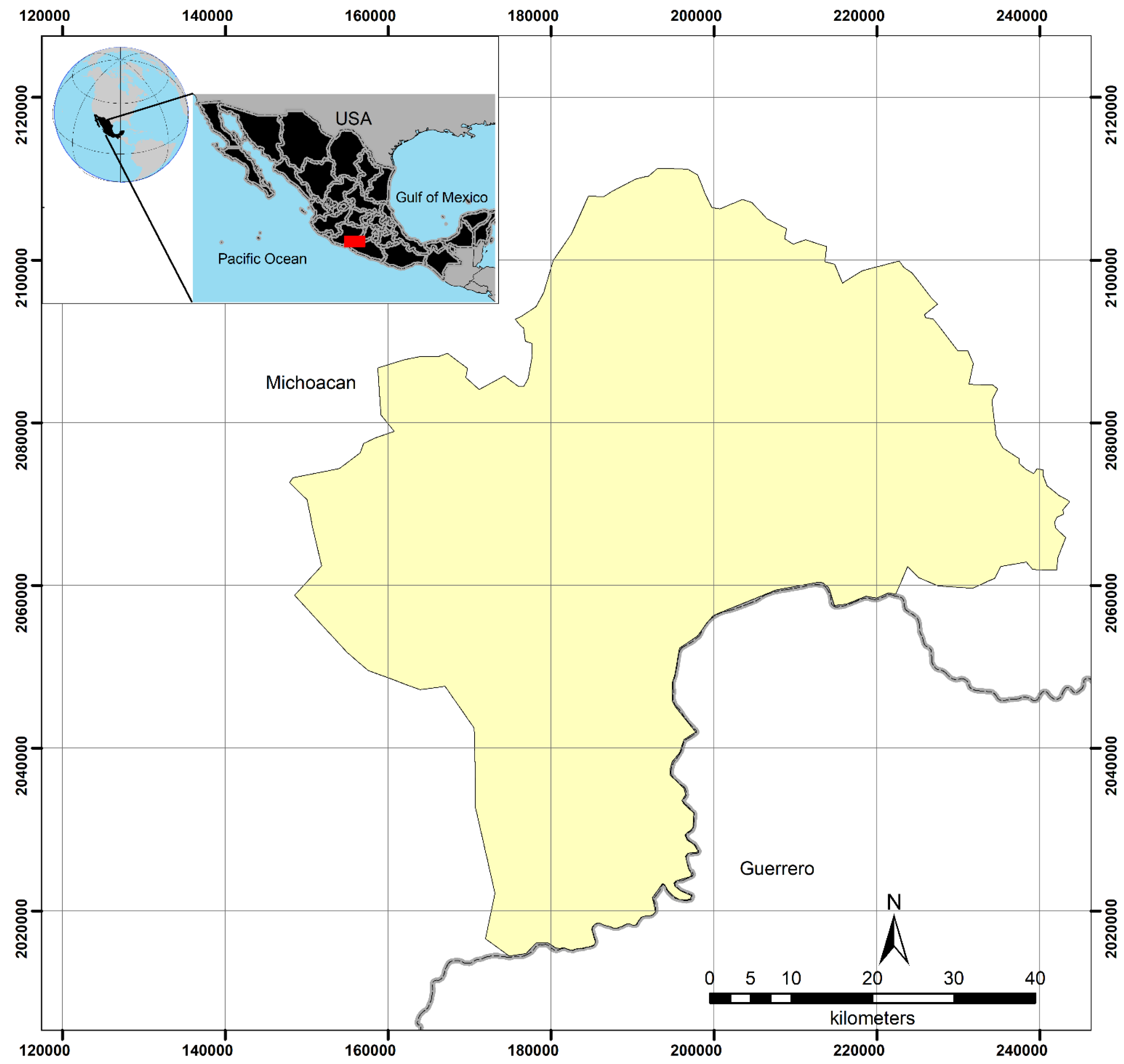
2.1. Study Area
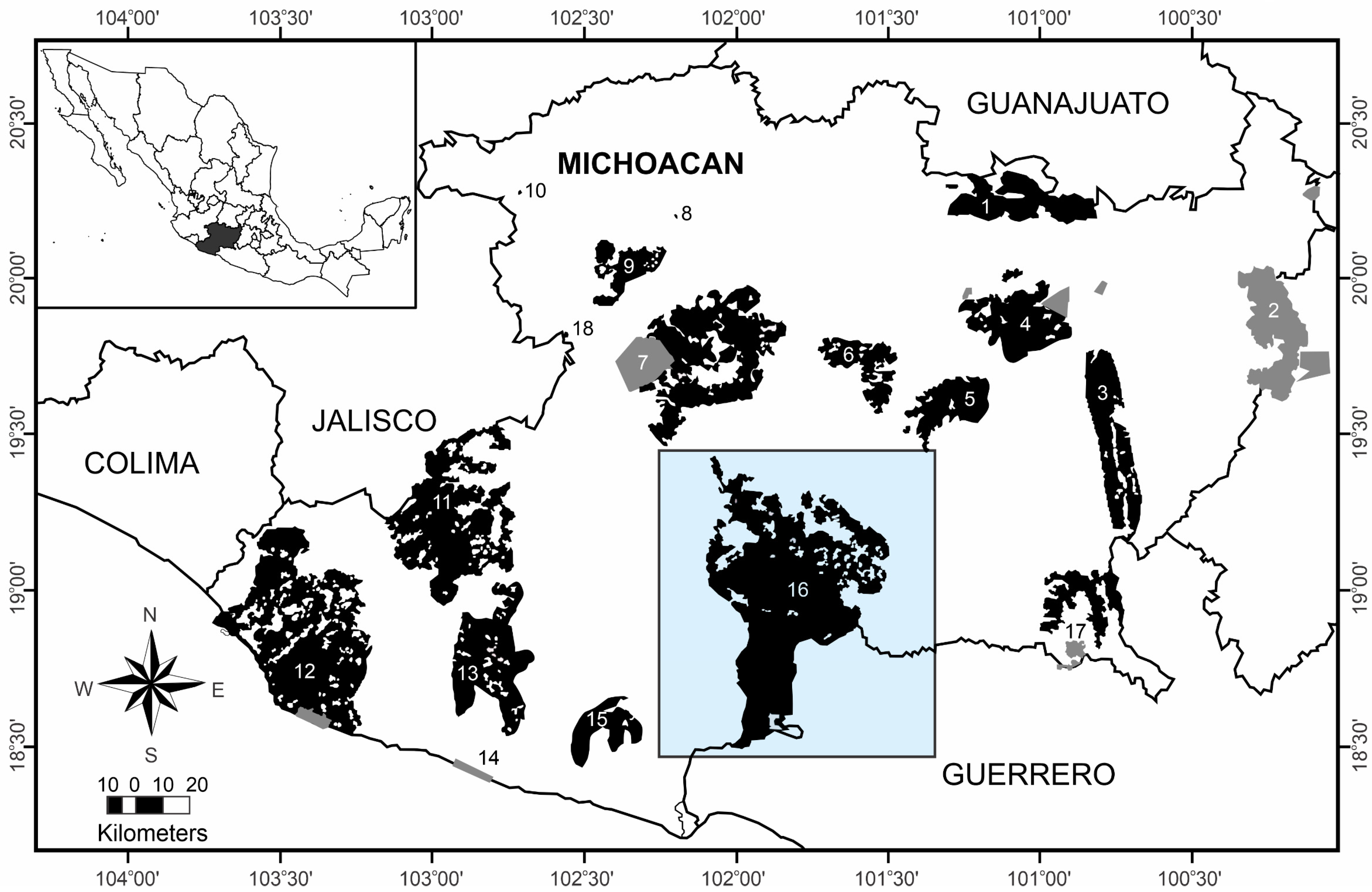
2.2. Macroregional State Level
2.3. Microregional Level
- (1)
- Enrollment of active NGOs that have played an important role in making local inhabitants aware of their land’s natural values (e.g., The Community Biodiversity Conservation Program, the Project for the Conservation and Sustainable Management of Forest Resources, Bajo Balsas Non-Governmental Organization).
- (2)
- Preparation of detailed cartography at a medium scale (1:100,000 and 1:50,000) to illustrate the interconnectedness of the agrarian community’s lands with various basins and sub-basins (water is a critical resource in the region), landcover, land use, human settlements, primary and secondary roads, and boundaries of agrarian communities.
- (3)
- Planning open public consultations to include small landowners, experienced technical service providers, ejido counselors, and livestock associations.
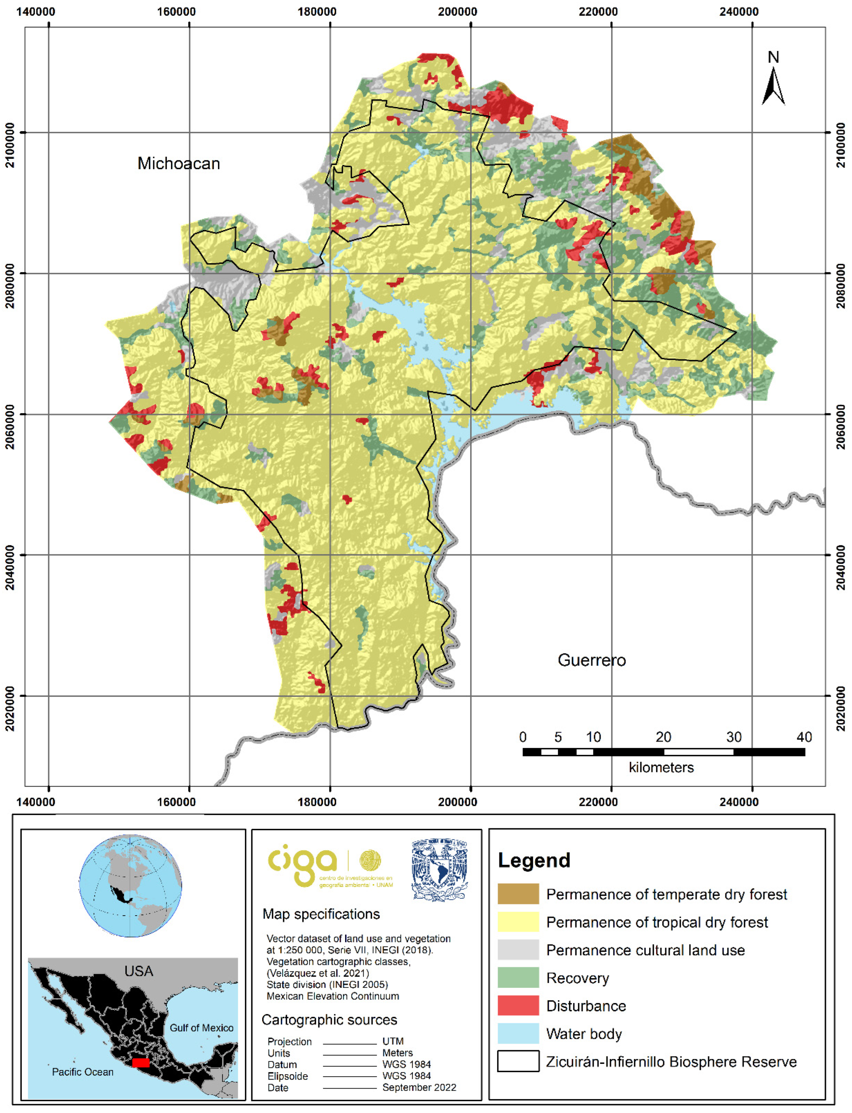
2.4. Efficiency Assessment of the Zicuirán-Infiernillo Biosphere Reserve
3. Results
3.1. The State System of Conservation (SSC)
3.2. Zicuirán-Infiernillo Biosphere Reserve Consultation
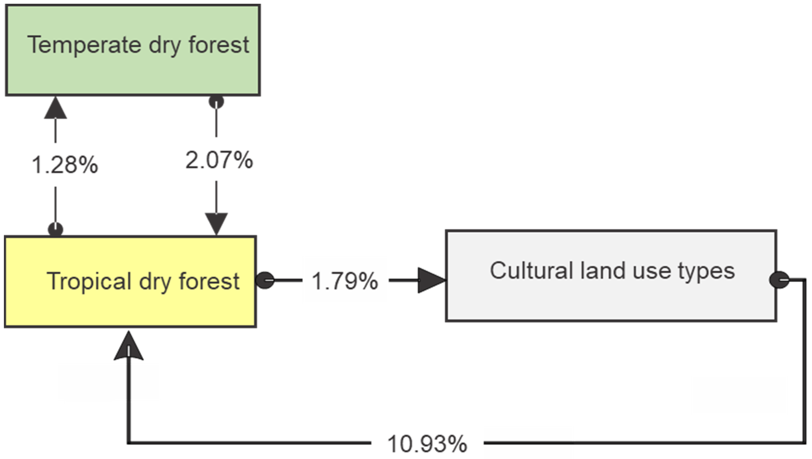
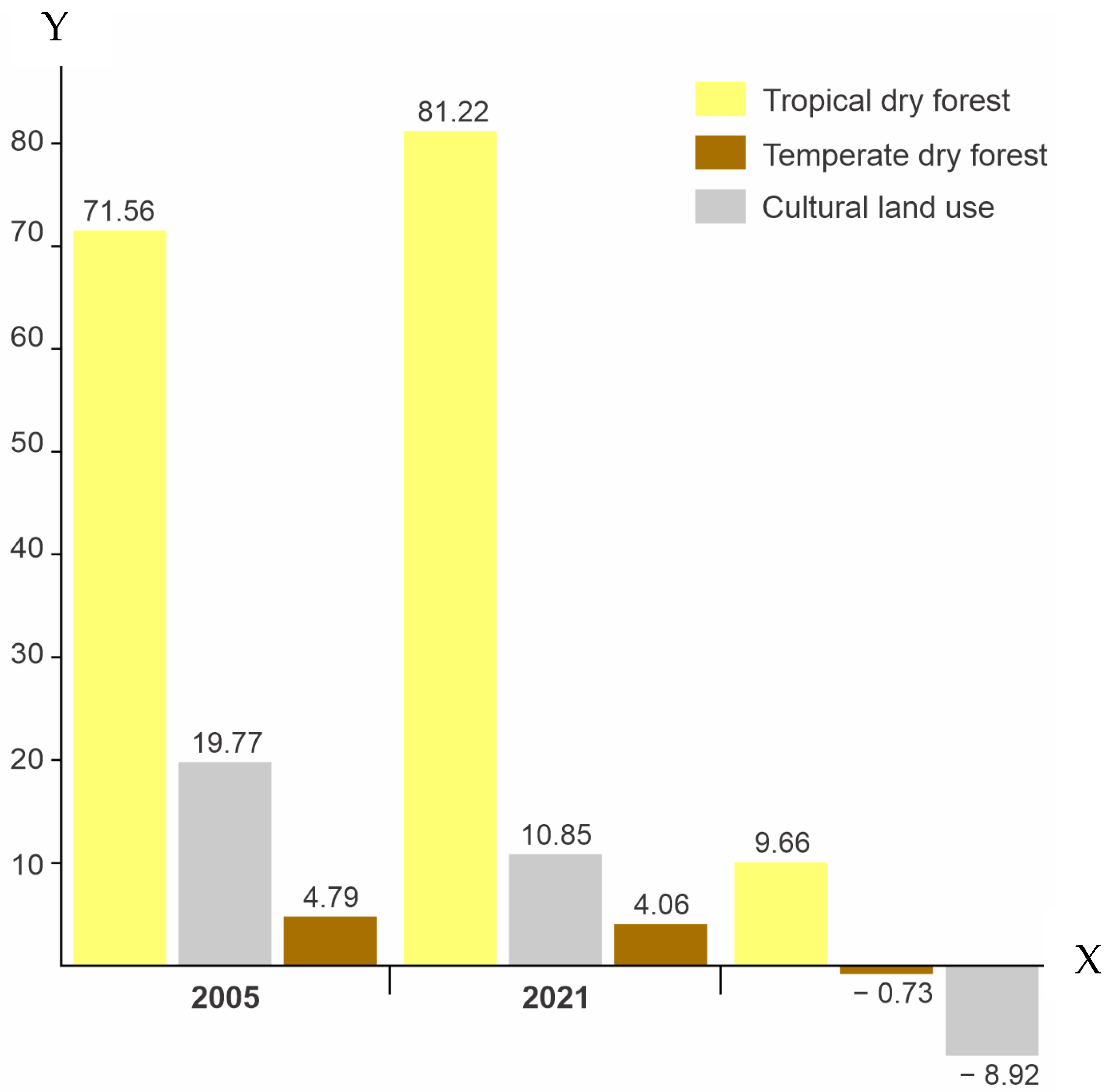
3.3. Biosphere Reserve Model Efficiency
4. Discussion
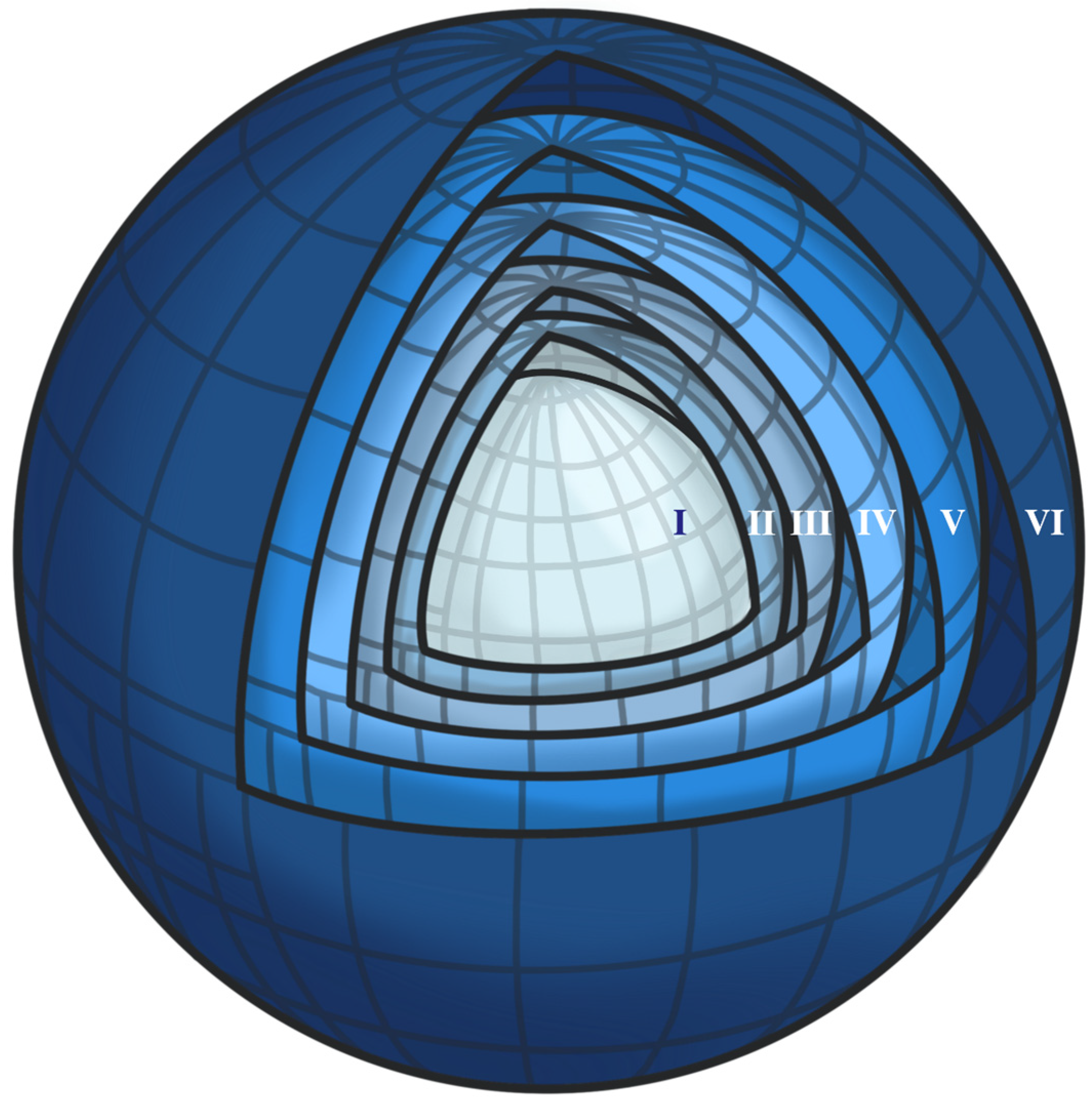
4.1. Multi(scale)stakeholder Integration
4.2. From State to National Scale
4.3. (Inter)tropical Outreach
Supplementary Materials
Author Contributions
Funding
Data Availability Statement
Acknowledgments
Conflicts of Interest
References
- Díaz, S.; Pascual, U.; Stenseke, M.; Martín-López, B.; Watson, R.T.; Molnár, Z.; Hill, R.; Chan, K.M.A.; Baste, I.A.; Brauman, K.A.; et al. Assessing nature’s contributions to people. Science 2018, 359, 270–272. [Google Scholar] [CrossRef]
- Curtis, P.G.; Slay, C.M.; Harris, N.L.; Tyukavina, A.; Hansen, M.C. Classifying drivers of global forest loss. Science 2018, 361, 1108–1111. [Google Scholar] [CrossRef] [PubMed]
- Terborgh, J.; van Schaik, C.; Davenport, L.; Rao, M. Making Parks Work: Strategies for Preserving Tropical Nature; Island Press: Washington, DC, USA, 2002. [Google Scholar]
- Brunner, R. Identification of the Most Essential Transboundary Protected Areas in Central and Eastern Europe; Council of Europe: Strasbourg, France, 2002. [Google Scholar]
- Yannelli, F.A.; Bazzichetto, M.; Conradi, T.; Pattison, Z.; Andrade, B.O.; Anibaba, Q.A.; Bonari, G.; Chelli, S.; Ćuk, M.; Damasceno, G.; et al. Fifteen emerging challenges and opportunities for vegetation science: A horizon scan by early career researchers. J. Veg. Sci. 2022, 33, e13119. [Google Scholar] [CrossRef]
- Watson, J.E.M.; Dudley, N.; Segan, D.B.; Hockings, M. The performance and potential of protected areas. Nature 2014, 515, 67–73. [Google Scholar] [CrossRef]
- Liu, J.; Linderman, M.; Ouyan, Z.; An, L.; Yang, J.; Zhang, H. Ecological degradation in protected areas: The case of wolong nature reserve for giant pandas. Science 2001, 292, 98–101. [Google Scholar] [CrossRef]
- Vanclay, J.K. The effectiveness of parks. Science 2001, 293, 1007. [Google Scholar] [CrossRef]
- Cumming, G.S.; Allen, C.R. Protected areas as social-ecological systems: Perspectives from resilience and social-ecological systems theory. Ecol. Appl. 2017, 27, 1709–1717. [Google Scholar] [CrossRef]
- Berkes, F.; Folke, C. Linking social and ecological systems for resilience and sustainability. BEIJER Discuss. Pap. 1998, 52, 1–23. [Google Scholar]
- Holling, C.; Gunderson, L. Resilience and adaptive cycles. In Understanding Transformations in Human and Natural Systems; Gunderson, L.H., Holling, C.S., Eds.; Island Press: Washington, DC, USA, 2022; pp. 25–62. [Google Scholar]
- Walker, B.H.; Anderies, J.M.; Kinzig, A.P.; Ryan, P. Exploring resilience in social-ecological systems through comparative studies and theory development: Introduction to the special issue. Ecol. Soc. 2006, 11, 12. [Google Scholar] [CrossRef]
- Cash, D.W.; Clark, W.C.; Alcock, F.; Dickson, N.M.; Eckley, N.; Guston, D.H.; Jäger, J.; Mitchell, R.B. Knowledge systems for sustainable development. Proc. Natl. Acad. Sci. USA 2023, 100, 8086–8091. [Google Scholar] [CrossRef] [PubMed]
- Ens, E.J.; Finlayson, M.; Preuss, K.; Jackson, S.; Holcombe, S. Australian approaches for managing ‘country’ using Indigenous and non-Indigenous knowledge. Ecol. Manage. Rest. 2012, 13, 100–107. [Google Scholar] [CrossRef]
- Ens, E.J.; Pert, P.; Clarke, P.A.; Budden, M.; Clubb, L.; Doran, B.; Douras, C.; Gaikwad, J.; Gott, B.; Leonard, S.; et al. Indigenous biocultural knowledge in ecosystem science and management: Review and insight from Australia. Biol. Conserv. 2015, 181, 133–149. [Google Scholar] [CrossRef]
- Bray, D.B.; Velázquez, A. From displacement-based conservation to place-based conservation. Conserv. Soci. 2009, 7, 11–14. [Google Scholar] [CrossRef]
- Pérez-Valladares, C.X.; Moreno-Calles, A.I.; Mas, J.F.; Velazquez, A. Species distribution modeling as an approach to studying the processes of landscape domestication in central southern Mexico. Landsc. Ecol. 2022, 37, 461–476. [Google Scholar] [CrossRef]
- Funtowicz, S.O.; Ravetz, J.R. Science for the post-normal age. Futures 1993, 25, 739–755. [Google Scholar] [CrossRef]
- UNCEN. Agenda 21, United Nations Conference on Environment and Development Rio de Janeiro, Brazil, 3 to 14 June 1992. 1992. Available online: https://sustainabledevelopment.un.org/content/documents/Agenda21.pdf?_gl=1*z77eo1*_ga*MzY5MDU3NDc3LjE2ODM4MjE0NjQ.*_ga_TK9BQL5X7Z*MTY4MzgyMTQ2My4xLjEuMTY4MzgyMTUyMy4wLjAuMA (accessed on 1 May 2023).
- Ostrom, E. Coping with tragedies of the commons. Annu. Rev. Polit. Sci. 1999, 2, 493–535. [Google Scholar] [CrossRef]
- Kania, J.; Kramer, M. Collective Impact; Stanford Social Innovation Review: Beijing, China, 2011. [Google Scholar]
- Wollenberg, E.; Anderson, J.; Edmunds, D. Pluralism and the less powerful: Accommodating multiple interests in local forest management. IJARGE 2001, 1, 199–222. [Google Scholar] [CrossRef]
- Ingersoll, D.W. Myth, Memory, and the Making of the American Landscape. In American Antiquity; Shackel, P.A., Ed.; University Press of Florida: Gainesville, FL, USA, 2003; pp. 189–190. [Google Scholar]
- Groombridge, B.; Jenkins, M.D. Global Biodiversity: Earth’s Living Resources in the 21st Century; World Conservation Press: Cambridge, UK, 2000. [Google Scholar]
- Sarukhán, J.; Urquiza-Haas, T.; Koleff, P.; Carabias, J.; Dirzo, R.; Ezcurra, E.; Cerdeira-Estrada, S.; Soberón, J. Strategic actions to value, conserve, and restore the natural capital of megadiversity countries: The case of Mexico. Bioscience 2015, 65, 164–173. [Google Scholar] [CrossRef]
- Velázquez, A.; Mas, J.F.; Díaz-Gallegos, J.R.; Mayorga-Saucedo, R.; Alcántara, P.C.; Castro, R.; Fernández, T.; Bocco, G.; Ezcurra, E.; Palacio, J.L. Patrones y tasas de uso del suelo en México. Gac. Ecol. 2002, 62, 21–37. [Google Scholar]
- Figueroa, D.; Galeana-Pizaña, J.M.; Núñez, J.M.; Gómez, C.A.; Hernández-Castro, J.R.; del Mar Sánchez-Ramírez, M.; Garduño, A. Assessing drivers and deterrents of deforestation in Mexico through a public policy tool. The adequacy of the index of economic pressure for deforestation. For. Policy Econ. 2021, 133, 102608. [Google Scholar] [CrossRef]
- CONANP. Áreas Naturales Protegidas. Comisión Nacional de Áreas Protegidas. 2022. Available online: https://www.gob.mx/conanp/documentos/areas-naturales-protegidas-278226 (accessed on 1 May 2023).
- Figueroa, F.; Sánchez-Cordero, V.; Illoldi-Rangel, P.; Linaje, M. Evaluación de la efectividad de las áreas protegidas para contener procesos de cambio en el uso del suelo y la vegetación. ¿Un índice es suficiente? Rev. Mex. Biodivers. 2011, 82, 951–963. [Google Scholar] [CrossRef]
- Morett-Sánchez, J.C.; Cosío-Ruiz, C. Outlook of ejidos and agrarian communities in Mexico. Agric. Soc. Desarro. 2017, 14, 125–152. [Google Scholar]
- Thoms, C.; Betters, D. The potential for ecosystem management in Mexico’s forest ejidos. For. Ecol. Manag. 1998, 103, 149–157. [Google Scholar] [CrossRef]
- FAO. Latin American and Caribbean Forestry Comission. The State of the Forest Sector in the Latin America and Caribben Region; Food and Agriculture Organization of the United Nations: Rome, Italy, 2021; Available online: https://www.fao.org/3/cb6002en/cb6002en.pdf (accessed on 1 May 2023).
- Bray, D.B. Las Empresas Forestales Comunitarias de México. Èxito en los Comunes y las Semillas de un Buen Antropoceno; La Cigarra Editorial: Coyoacán, Mexico, 2022; p. 442. [Google Scholar]
- Durán, E.; Bray, D.B.; Velázquez, A.; Larrazábal, A. Multi-Scale Forest Governance, Deforestation, and Violence in Two Regions of Guerrero, Mexico. World Dev. 2011, 39, 611–619. [Google Scholar] [CrossRef]
- Gopar-Merino, L.F.; Velázquez, A.; de Azcárate, J.G. Bioclimatic mapping as a new method to assess effects of climatic change. Ecosphere 2015, 6, 1–12. [Google Scholar] [CrossRef]
- Cruz Angón, A.; Nájera, C.; Melgarejo, D. La Biodiversidad de Michoacán: Estudio de Estado 2; CONABIO: Mexico City, Mexico, 2019; Volume 3. [Google Scholar]
- Velazquez, A.; Medina-García, C.; Gopar-Merino, F.; Duran, E.; Pérez-Vega, A.; Mas, J.F.; Giménez de Azcarate, J.; Blanco-García, A.; López-Barrera, F.; Castro-López, V.; et al. Merged phytosociological and geographical approach for multiple scale vegetation mapping as a baseline for public environmental policy in Mexico. Appl. Veg. Sci. 2021, 24, e12595. [Google Scholar] [CrossRef]
- Ramos-Gutiérrez, L.D.J.; Montenegro-Fragoso, M. La generación de energía eléctrica en México. Tecnol. Cienc. Agua 2012, 3, 197–211. [Google Scholar]
- Cuevas, G.; Mas, J.F. Land use scenarios: A communication tool with local communities. In Modelling Environmental Dynamics; Paegelow, M., Camacho Olmedo, M.T., Eds.; Springer: Berlin/Heidelberg, Germany, 2008; pp. 223–246. [Google Scholar] [CrossRef]
- Rangel-Landa, S.; Blanco-García, A.; Guzmán-Gómez, E.L.; Saucedo-Gudiño, M.A.; Steinmann, V. Recursos Forestales y su Manejo como Legado Biocultural de México: El Caso de la Tierra Caliente de Michoacán. La Jorn. Campo. 2022. Available online: https://www.researchgate.net/publication/362080029_Recursos_forestales_y_su_manejo_como_legado_biocultural_de_Mexico_el_caso_de_la_Tierra_Caliente_de_Michoacan (accessed on 1 May 2023).
- Velázquez, A.; Duran, E.; Ramírez, I.; Mas, J.F.; Bocco, G.; Ramírez, G.; Palacio, J.L. Land use-cover change processes in highly biodiverse areas: The case of Oaxaca, Mexico. Glob. Environ. Chang. 2003, 13, 175–184. [Google Scholar] [CrossRef]
- SEMARNAT-CONANP. Programa de Manejo Reserva de la Biosfera Zicuirán-Infiernillo; Secretaría de Medio Ambiente y Recursos Naturales: Tlalpan, Mexico, 2014. [Google Scholar]
- Rosado-González, E.M.; Martinho Lourenço, J.M.; Palacio-Prieto, J.L.; Abreu Sá, A. Collaborative mapping on sustainable development goals in Latin America UNESCO global geoparks: A methodological discussion. Int. J. Geoheritage Parks 2023, 11, 203–220. [Google Scholar] [CrossRef]
- Holzer, J.M.; Carmon, N.; Orenstein, D.E. A methodology for evaluating transdisciplinary research on coupled socio-ecological systems. Ecol. Indic. 2018, 85, 808–819. [Google Scholar] [CrossRef]
- Maldonado, E.; Herrera, H.A.; Guerrero, H.R. Diseño de política ambiental e innovación social. Aportaciones teórico-metodológicas para la gestión sustentable de áreas naturales protegidas. Econ. Soc. 2018, 22, 111–128. [Google Scholar]
- Brenner, L.; De la Vega Leinert, A.C. La gobernanza participativa de áreas naturales protegidas: El caso de la Reserva de la Biosfera El Vizcaíno. Reg. Soc. 2014, 26, 183–213. [Google Scholar] [CrossRef]
- Rosete, F.A.; Velazquez, A.; Bocco, G.; Espejel, I. Multi-scale land cover dynamics of semiarid scrubland in Baja California, Mexico. Reg. Environ. Chang. 2014, 14, 1315–1328. [Google Scholar] [CrossRef]
- Durand, L.; Jímenez, J. Sobre áreas naturales protegidas y la construcción de no-lugares. Notas para México. Rev. Líder 2010, 12, 59–72. [Google Scholar]
- Kolb, M.; Mas, J.F.; Galicia, L. Evaluating drivers of land-use change and transition potential models in a complex landscape in Southern Mexico. Int. J. Geogr. Inf. Sci. 2013, 27, 1804–1827. [Google Scholar] [CrossRef]
- Velázquez, A.; Bocco, G.; Romero, F.J.; Vega, A.P. A landscape perspective on biodiversity conservation. Mt. Res. Dev. 2003, 23, 240–246. [Google Scholar] [CrossRef]
- López-Martínez, O.; Cuanalo de la Cerda, H.E. Participatory action research in the design, construction, and evaluation of improved cook stoves in a rural Yucatec Maya community. Action Res. 2020, 18, 490–509. [Google Scholar] [CrossRef]
- Salas, S.; Fraga, J.; Euan, J.; Chuenpagdee, R. Common Ground, Uncommon Vision: The importance of cooperation for small-scale fisheries governance. In Interactive Governance for Small-Scale Fisheries; Jentoft, S., Chuenpagdee, R., Eds.; MARE Publication Series; Springer: Cham, Switzerland, 2015; pp. 477–493. [Google Scholar] [CrossRef]
- Martínez i Coma, F.M.; Nai, A. Ethnic diversity decreases turnout. Comparative evidence from over 650 elections around the world. Elect. Stud. 2017, 49, 75–95. [Google Scholar] [CrossRef]
- Xu, H.; Cao, Y.; Yu, D.; Cao, M.; He, Y.; Gill, M.; Pereira, H.M. Ensuring effective implementation of the post-2020 global biodiversity targets. Nat. Ecol. Evol. 2021, 5, 411–418. [Google Scholar] [CrossRef]
- Brechin, S.R.; Fortwangler, C.L.; Wilshusen, P.R.; West, P.C. Contested Nature: Promoting International Biodiversity with Social Justice in the Twenty-First Century; State University of New York Press: Albany, NY, USA, 2003. [Google Scholar]


| The State System of Conservation | Established Protected Areas by 2014 | ||||
|---|---|---|---|---|---|
| Number on Map | Areas | Surface (Km2) | % | Surface (Km2) | % |
| 1 | Cuitzeo-Copandaro | 421.52 | 0.71 | 2.54 | 0.02 |
| 2 | Monarch Butterfly Biosphere Reserve | 562.79 | 0.95 | 562.79 | 5.37 |
| 3 | Tiquicheo-Tzitzio-Madero | 546.14 | 0.93 | 0.00 | 0.00 |
| 4 | Morelia-Tzitzio | 540.64 | 0.92 | 66.59 | 0.64 |
| 5 | Madero-Tacambaro | 317.19 | 0.54 | 0.77 | 0.01 |
| 6 | Opopeo | 244.18 | 0.41 | 0.00 | 0.00 |
| 7 | Pico de Tancítaro | 1193.98 | 2.02 | 222.22 | 2.12 |
| 8 | Parque Nacional Lago de Camecuaro | 0.11 | 0.00 | 0.11 | 0.00 |
| 9 | Los Reyes | 206.49 | 0.35 | 0.00 | 0.00 |
| 10 | Parque Juárez de Jiquilpa | 0.08 | 0.00 | 0.08 | 0.00 |
| 11 | Coalcoman | 1110.34 | 1.88 | 0.00 | 0.00 |
| 12 | Chinicuila-Coahuayana | 1615.54 | 2.74 | 33.94 | 0.32 |
| 13 | Aguililla-Coalcoman-Tumbiscatio | 649.26 | 1.10 | 0.00 | 0.00 |
| 14 | Playa Mexiquillo | 31.35 | 0.05 | 31.35 | 0.00 |
| 15 | Arteaga | 241.73 | 0.41 | 0.00 | 0.00 |
| 16 | La Huacana-Churumuco-Artega | 2418.77 | 4.10 | 0.00 | 0.00 |
| 17 | Huetamo-Turitzio | 298.40 | 0.51 | 0.00 | 0.00 |
| 18 | Chorros del Varal (Los Reyes) | 0.73 | 0.00 | 0.73 | 0.01 |
| Total | 10,399.24 | 17.63 | 921.13 | 8.79 | |
| Level | Stakeholder | Scale | Governance Body | Decision Drivers |
|---|---|---|---|---|
| I | Peasant | Meters | Family hold | Livelihood productivity |
| II | Agrarian community | Hectares | General Assembly | Territorial services |
| III | Municipality | km2 | Mayor | Territorial control |
| IV | State | Hundreds of km2 | Governor/State Minister | Socioeconomic policies |
| V | Nation | Thousands of km2 | President/Minister | Political interests |
| VI | Macroregion | Millions of km2 | Commissioner | Macroeconomic interests |
Disclaimer/Publisher’s Note: The statements, opinions and data contained in all publications are solely those of the individual author(s) and contributor(s) and not of MDPI and/or the editor(s). MDPI and/or the editor(s) disclaim responsibility for any injury to people or property resulting from any ideas, methods, instructions or products referred to in the content. |
© 2023 by the authors. Licensee MDPI, Basel, Switzerland. This article is an open access article distributed under the terms and conditions of the Creative Commons Attribution (CC BY) license (https://creativecommons.org/licenses/by/4.0/).
Share and Cite
Sosa, N.; Torres, A.; Castro-Lopez, V.; Velazquez, A. Participatory Landscape Conservation: A Case Study of a Seasonally Dry Tropical Forest in Michoacan, Mexico. Land 2023, 12, 2016. https://doi.org/10.3390/land12112016
Sosa N, Torres A, Castro-Lopez V, Velazquez A. Participatory Landscape Conservation: A Case Study of a Seasonally Dry Tropical Forest in Michoacan, Mexico. Land. 2023; 12(11):2016. https://doi.org/10.3390/land12112016
Chicago/Turabian StyleSosa, Neyra, Alejandro Torres, Valerio Castro-Lopez, and Alejandro Velazquez. 2023. "Participatory Landscape Conservation: A Case Study of a Seasonally Dry Tropical Forest in Michoacan, Mexico" Land 12, no. 11: 2016. https://doi.org/10.3390/land12112016
APA StyleSosa, N., Torres, A., Castro-Lopez, V., & Velazquez, A. (2023). Participatory Landscape Conservation: A Case Study of a Seasonally Dry Tropical Forest in Michoacan, Mexico. Land, 12(11), 2016. https://doi.org/10.3390/land12112016